BJHS, 1991, 24, 159–92
Charles Darwin as a prospective geological author
SANDRA HERBERT*
THE PROSPECTIVE AUTHOR
On occasion Charles Darwin can seem our scientific contemporary, for the subjects he engaged remain engaging today, but in his role as author he belongs to the past. It is not customary today for scientists to write book after book, as Darwin did, or for these books to serve as the primary vehicle of scientific communication. For Darwin, however, the book was central. He wrote at least eighteen, depending on what one counts; in his Autobiography he entitled the section describing his most important work 'An account how several books arose'1; and in his personal Journal, begun in August 1838 after he had come to a mature sense of himself, he organized entries around his books. A characteristic entry is that for 1846: 'Oct. 1st. Finished last proof of my Geolog. Observ. on S. America; This volume, including Paper in Geolog. Journal on the Falkland Islands took me 18 & ½ months:…'.2 Further, almost always he had a book under way: when one was complete, the next was begun.3 He called them the milestones to his life.4
* Department of History, University of Maryland, Baltimore County Campus, Catonsville, Maryland 21228, USA.
1 For the Table of Contents see N. Barlow (ed.), The Autobiography of Charles Darwin 1809–1882, London, 1958, p. 19 (hereafter Autobiography). In the text itself Darwin used the more general term 'My Several Publications' (p. 116).
2 F. Burkhardt and S. Smith; C. Bowman, J. Browne, A. S. Burkhardt, D. Kohn, W. Montgomery, S. V. Pocock, M. L. Richmond, A. Secord, N. C. Stevenson (eds.), The Correspondence of Charles Darwin, 6 † vols, Cambridge, 1985–, iii, p. 397 (hereafter Correspondence); G. R. de Beer, 'Darwin's Journal', Bull. Br. Mus. (Nat. Hist.) Hist. Ser. (1959), 2, p. 11.
3 There were interesting breaks in this pattern. In 1844, after completing Volcanic Islands but before beginning Geological Observations on South America, Darwin allowed himself five months, from 13 February to 5 July, to write up a 230 page sketch of his species theory. He also lingered between sorting his species notes in 1854 and actually beginning to write in 1856. Otherwise the interval between the completion of one book and the beginning of another was short. Until 1861 Darwin also cleared his desk of one book before starting another. In that year he began work on his orchid book before finishing Variation Under Domestication. In his later botanical works the ending of the writing of one and the beginning of another was also not so sharp as formerly, as in 1873 when he began on fertilization and then turned to insectivorous plants. de Beer, op. cit. (2), pp. 10–11, 13–15, 19; C. Darwin, Geological Observations on Volcanic Islands, Visited During the Voyage of H.M.S. 'Beagle', together with Some Brief Notices on the Geology of Australia and the Cape of Good Hope. Being the Second Part of the Voyage of the 'Beagle', Under the Command of Capt. FitzRoy, R.N., During the Years 1832 to 1836, London, 1844 (hereafter VI); Geological Observations on South America. Being the Third Part of the Geology of the Voyage of the 'Beagle', Under the Command of Capt. FitzRoy, R.N. During the Years 1832 to 1836, London, 1846 (hereafter GSA); The Variation of Animals and Plants under Domestication, 2 vols, London, 1868. For Darwin's other works see R. B. Freeman, The Works of Charles Darwin. An Annotated Bibliographical Handlist, 2nd edn, Folkestone, Hamden, 1977.
4 Autobiography, op. cit. (1), p. 136.
Geology figures prominently in Darwin's career as an author because it was the first subject on which he planned to write a book. At the first stop of the Beagle, São Tiago in the Cape Verde Islands, Darwin worked out some of the geology, and
It then first dawned on me that I might perhaps write a book on the geology of the various countries visited, and this made me thrill with delight. That was a memorable hour to me, and how distinctly I can call to mind the low cliff of lava beneath which I rested, with the sun glaring hot, a few strange desert plants growing near, and with living corals in the tidal pools at my feet.5
The answer to the question 'Why geology?' is multiple. Having come directly from Adam Sedgwick's tutelage, Darwin believed himself competent to do the job, and, as he later wrote, modestly, in the Admiralty's Manual of Scientific Enquiry, 'perhaps no science requires so little preparatory study as geology, and none so readily yields, especially in foreign countries, new and striking points of interest.'6 Certainly earlier collectors had emphasized zoology and botany over geology. There was also some expectation from above. Robert FitzRoy, commander and later captain of the Beagle, had explicitly identified geology as an area of study lacking on the first Beagle voyage of 1826–30, with a consequent loss of practical knowledge, as, for example, with respect to the possible presence of metal in the mountains of Tierra del Fuego.7 Francis Beaufort, hydrographer to the navy, had also required the Beagle's crew to inspect coral formations with an eye to testing current views.8
The question 'Why a book rather than articles?' may be answered only by surmise. Articles must be placed in a journal, and it was not initially obvious where such articles might find a certain home, though, among others, both the Geological and Geographical Societies' publications offered possibilities, as did the newly established Transactions of the Cambridge Philosophical Society. Perhaps a deeper answer would be that Darwin was already thinking expansively and that a book-length format seemed more commensurate with his ambition. There were instances of such works before him – the first volume of Lyell's Principles of Geology published the previous year, Leopold von Buch on Norway and Lapland, and the massive Personal Narrative of Alexander von Humboldt, which was heavily geological and had been recommended to Darwin as showing 'the right spirit with wh. a man should set to work'.9 Still, Darwin's decision in favour of a book was bold.
5 Autobiography, op. cit. (1), p. 81. For Darwin's recollection in September 1836 of his first visit to São Tiago see R. D. Keynes (ed.), Charles Darwin's 'Beagle' Diary, Cambridge, 1988, p. 437 (hereafter Diary).
6 C. Darwin, 'Geology' in J. F. W. Herschel (ed.), A Manual of Scientific Enquiry, Prepared for the Use of Her Majesty's Navy and Adapted for Travellers in General, London, 1849, p. 158. On Darwin's interest in guaranteeing the novelty of his observations and collections one may note his temporary, though real, irritation at having Alcide Charles Victor Dessalines d'Orbigny as a rival in South America; Correspondence, op. cit. (2), i, pp. 280, 462. Also see J. Secord, pp. 153–6, this volume.
7 R. FitzRoy (ed.), Narrative of the Surveying Voyages of His Majesty's Ships 'Adventure' and 'Beagle' Between the Years 1826 and 1836, Describing their Examination of the Southern Shores of South America, and the 'Beagle's' Circumnavigation of the Globe, 3 vols † appendix, London, 1839, i [Proceedings of the First Expedition, 1826–1830, Under the Command of Captain P. Parker King, R.N., F.R.S.], p. 385.
8 FitzRoy, op. cit. (7), ii [Proceedings of the Second Expedition, 1831–1836, under the Command of Captain Robert Fitz-Roy, R.N.], p. 38.
9 C. Lyell, Principles of Geology, Being an Attempt to Explain the Former Changes of the Earth's Surface, by Reference to Causes Now in Operation, 3 vols [vol. 1, 1830, vol. 2, 1832, vol. 3, 1833], London, 1830–33. Darwin's copy of volume one, which accompanied him on the voyage, is inscribed 'From Capt FitzRoy'. On the circumstances of Lyell's composition of the first volume see L. Wilson, Charles Lyell: The Years to 1841, New Haven, 1972, chapter 9 and the introduction by M. J. S. Rudwick to the 1970 J. Cramer reprint edition of the Principles. Another work Darwin frequently used while on board the Beagle was L. von Buch, Travels through Norway and Lapland…Translated by John Black with Notes by Robert Jameson, London, 1813. Of roughly equal importance as Lyell to Darwin was his copy of Alexander von Humboldt, Personal Narrative of Travels to the Equinoctial Regions of the New Continent, During the Years 1799–1804…Translated into English by Helen Maria Williams, 7 vols, London, 1819–29. Vols 1 and 2, in one, 3rd edn, were inscribed, 'J. S. Henslow to his friend C. Darwin on his departure from England upon a voyage round the World. 21 Sept 1831.' The remark praising Humboldt was in a letter from A. Sedgwick to Darwin dated 18 September 1831, Correspondence, op. cit. (2), i, p. 157. (Proximity of date between Sedgwick's letter and Henslow's gift suggests the possibility of some communication between the two.) For a list of books known to be aboard the Beagle see Correspondence, op. cit. (2), i, appendix iv. Darwin's copies of the works cited above are at Cambridge University Library.
Perhaps, and here again one can only surmise, the legacy of his grandfather Erasmus built his confidence. As a prospective geological author Charles Darwin would have inherited a dual legacy from his grandfather. Erasmus Darwin provided the model of a prolific author and one who had chosen to speculate on the largest geological questions, the history of the planet and the structure of the interior of the earth. On this point one cannot pass without calling to mind Erasmus Darwin's figuring of the interior of the earth as it appeared in the Botanic Garden (Figure 1). A copy of this work was part of his grandson's library and bears the inscription 'C. Darwin 1826'.10
The consequence of Darwin's early decision to write a book was that his copious notes on the geology of the voyage were crafted with the goal of publication in mind. 'Research' and 'writing up' ran together. Indeed, in later life Darwin would recommend extensive note-taking along with section-drawing, as a method for observing in geology, arguing, quoting Bacon, that 'Reading maketh a full man, conference a ready man, and writing an exact man;…'.11 Darwin's regularity in note taking is a convenient fact for the historian since it allows access to his thought as it developed. His intent as an author is also necessary for the historian to consider as it explains the pattern of his geological writing during the voyage – its abundance, recursivity, and movement towards synthesis.
Darwin's geological manuscripts from the voyage fall into five categories:
1 The field notebooks.12
2 The specimen notebooks.13
10 E. Darwin, The Botanic Garden, a Poem, in Two Parts. Part 1. The Economy of Vegetation. Part 2 The Loves of the Plants. [Part 1 is 1791 1st edn, Part 2 is 1790 2nd edn], London, 1791, 1790. Copy at Cambridge University Library. Part 1, pp. 64–6 contains the core of Erasmus Darwin's geological speculations: a 'note' on the formation of granite considered primarily as a species of lava, the section of the earth (Figure 1, facing p. 65), and a 'geological recapitualtion' arguing for the original projection of the earth from the sun and its gradual cooling to form a crust, and presenting explanations for the origin of major features of the earth's present topography. In the section on granite the views of James Hutton regarding the ongoing creation of continents and the eternality of the globe are described, though Erasmus Darwin's comments in the 'recapitulation' do not suggest that he shared Hutton's views on the history of the earth; thus Darwin argued that earthquake and volcanic activity of 'modern days' is 'of small extent and insignificant' as compared to an earlier time (p. 66). Also see D. King-Hele, Doctor of Revolution: the Life and Genius of Erasmus Darwin, London, 1977, pp. 220–4.
11 Darwin, op. cit. (6), p. 163.
12 Extant notebooks are listed in Correspondence, op. cit. (2), i, pp. 545–46. Extracts from the notebooks were published in N. Barlow, Charles Darwin and the Voyage of the 'Beagle', London, 1945.
13 The four geological specimen notebooks are on deposit at Cambridge University Library. The bulk of Darwin's geological specimens are held by the Department of Earth Sciences, University of Cambridge.
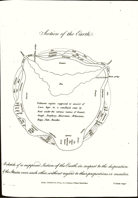
Figure 1. 'Section of the Earth' from Erasmus Darwin's The Botanic Garden. The Inscription reads 'A sketch of a supposed Section of the Earth in respect to the disposition of the Strata over each other without regard to their proportions or number'.
3 The geological notes proper, generally organized according to locality, and running to 1383 pages, as opposed to 368 pages for the zoological notes.14 The physical appearance of these notes suggests Darwin's method of composition. Notes are on one side of the page only, specimen numbers keyed into the notes and usually appearing in the left-hand margin. Versos are left empty for footnotes, which are plentiful and give the manuscript a dense and almost prematurely scholarly appearance. Throughout the geological notes proper is evidence of later annotation, some dating from the voyage as Darwin revised and enlarged his own earlier work, and some dating from after the voyage as Darwin reworked his material for publication.15
4 Several synthetic essays written towards the end of the voyage including among them 'Coral Islands', 'Recapitulation and concluding remarks' on the geology of South America, and a set of 36 folio pages on cleavage.16
5 Two notebooks, 'Santiago Book' and 'RN' or the 'Red Notebook', which Darwin used partly to prepare for publication.17
With the aid of these manuscripts one can reconstruct Darwin's overall vision of geology during the voyage. While I cannot be comprehensive, I will pick up Darwin's writing at three stages: first, the beginning of the voyage, which will illustrate his methods and choice of themes and allow for comparison of his work with that of geologists at home; second, midway through the voyage, when he had arrived at his own point of view on the key subject of the action of elevation; and, third, towards the close of the voyage when the prospect of publication stood before him as an immediate objective. As is well known, Darwin's geological work eventually issued in not one but three separate books: Coral Reefs in 1842, Volcanic Islands in 1844, and Geological Observations on South America in
14 H. Gruber and V. Gruber, 'The eye of reason: Darwin's development during the Beagle voyage', Isis, (1962), 53, p,. 189.
15 The main run of Darwin's geology notes is contained in DAR 32–38. A portion of these notes, as with the zoology notes in DAR 30–31, were kept on rule-lined paper bearing a C. Wilmot 1828 watermark. The paper shows signs of having been bound. In the course of the voyage Darwin's note-taking style evolved. Originally notes on the versos of pages referred to the facing page; at DAR 32.1:61 he altered his practice to have notes on versos refer to the text on their rectos. Also, specimen numbers began by being integrated into the text; later they moved out to the left margin. Volumes of Darwin mauscripts, noted as 'DAR', are at Cambridge University Library.
16 All in DAR 41, the first two in the hand of Syms Covington, Darwin's servant and copyist, with Darwin's corrections added in his own hand. A holograph version of 'Coral Islands', differing at points from the fair copy, is also in DAR 41 and has been published in D. R. Stoddart (ed.), 'Coral islands, by Charles Darwin', Atoll Research Bulletin, 88, Washington, DC, Pacific Science Board, National Academy of Sciences, 1962 [hereafter CI].
17 The notebook labelled 'Santiago Book', catalogued 1.18 at Down House, is unpublished. It was begun about August 1834 and used as a field notebook through February 1835. Thereafter until approximately midway in 1836 the notebook was used for more general speculations. On dating the notebook, see F. J. Sulloway, 'Further remarks on Darwin's spelling habits', J. Hist. Biol. (1983), 16, pp. 367–76. The Red Notebook, which dates from late May 1836 to late May/mid-June 1837, has been published in P. H. Barrett, P. J. Gautrey, S. Herbert, D. Kohn, and S. Smith (eds.), Charles Darwin's Notebooks, 1836–1844: Geology, Transmutation of Species, Metaphysical Enquiries ['Red Notebook' ed. S. Herbert], London and Ithaca, 1987 [hereafter Notebooks, 'RN' for 'Red Notebook']. For a discussion of dating the notebook see pp. 17–18. Also available as S. Herbert (ed.). The Red Notebook of Charles Darwin, London and Ithaca, 1980.
7
BHS 24
1846.18 His synthetic essays from the close of the voyage are therefore the more interesting as illustrating the unity of his vision.
METHODS AND THEMES
Darwin began his geologizing in January 1832 at Quail Island (presently Ilheu de Santa Maria), a speck of land about a mile in circumference lying in the harbour of Porto Praya, St Jago (São Tiago) in the Cape Verde Islands (Figure 2). He called Quail Island his keystone to be used in unravelling the structure of the main island of São Tiago. His interpretation of both Quail Island and São Tiago is that they are volcanic islands that were for some period submerged beneath the sea where they collected marine beds, and then another layer of melted volcanic material. While on Quail Island he wrote, 'the whole mass was then raised since which or at the time there has been a partial sinking. – I judge of this from the appearance of distortion, & indeed, the distant line of coast seen to the East [of Quail Island looking towards the mainland] which is considerably higher bears me out.'19 In conjunction with his interpretation Darwin provided a section drawing and a listing of beds from the lowest to the highest (Figure 3).20 The letter designations for the section refer to the following beds:
A The lowest rocks all contain included crystals[.] the most common is (1) Augite & Olivine (?) there are masses of(2) amygaloid. [sic] containing in cavities minute white crystals: Many of these rocks have undergone great (3) decompos[ition], in parts becoming either a
18 C. Darwin, The Structure and Distribution of Coral Reefs. Being the First Part of the Geology of the Voyage of the 'Beagle', Under the Command of Capt. FitzRoy, R.N. During the Years 1832–1836, London, 1842 [hereafter CR]. VI, op. cit. (3); GSA, op. cit. (3).
19 DAR 32.1:18. The underlining of 'partial sinking' is a later pencil addition, as is marginal scoring that appears in the manuscript next to the second sentence quoted. In transcriptions from Darwin's notes single angled brackets [< >] represent deletions, doubled angled brackets (« ») represent insertions. At a prominent place in the literature there is a statement regarding Darwin's experiences at Quail Island requiring amendment. In his recent edition of the Diary [op. cit. (5), pp. 24–5] Keynes quoted the following passage from Darwin's Autobiography: 'The geology of St. Jago is very striking yet simple: a stream of lava formerly flowed over the bed of the sea, formed of triturated recent shells and corals, which it has baked into a hard white rock. Since then the whole island has been upheaved. But the line of white rock revealed to me a new and important fact, namely that there had been afterwards subsidence round the craters, which had since been in action, and had poured forth lava.' Keynes then suggested that, 'The absence of a reference in the Diary to the line of white rock may be because at this stage CD had far from satisfied himself as to its geological origin.' However, what the Diary does lack is contained in the full geological notes, at least in regard to a basic narrative regarding the origin of the island. On Quail Island Darwin observed a 'white line of raised coast' (DAR 32.1:15). (See bed 'D' in Figure 3). Then he applied the interpretation of his 'keystone', Quail Island, to São Tiago (DAR 32.1.21): 'The whole country has a desolate wild appearance. & it is impossible for an instant to view it without attributing the formation to Volcanic origin…The black & precipitous cliffs that surround the Eastern side of the harbor of Porto Praya are <illeg.> traversed by a white band. which stretches away for <some> «many» miles in an horizontal direction. This line which is very striking. proves to be the upraised beach of a former coast:…'. On this reading see Secord, op. cit. (6). Also see S. Herbert, 'Darwin as a geologist', Sci. Am. (1986), 254, no. 5, pp. 117–18.
20 The section drawing has been traced from DAR 32.1: 16A. In the drawing the alphabetical letters and the phrase 'Level of Sea' are in ink; the remainder of the drawing is in pencil. The letter 'K' refers to a dislocation. The rule-drawn diagonal line represents the dip. The encircled 'Lava 1836' is a pencilled notation Darwin made on a return visit to the island in 1836. Passages quoted in discussion of the section drawing are from DAR 32.1: 15–18 and versos with occasional reference to the first geological specimen notebook.
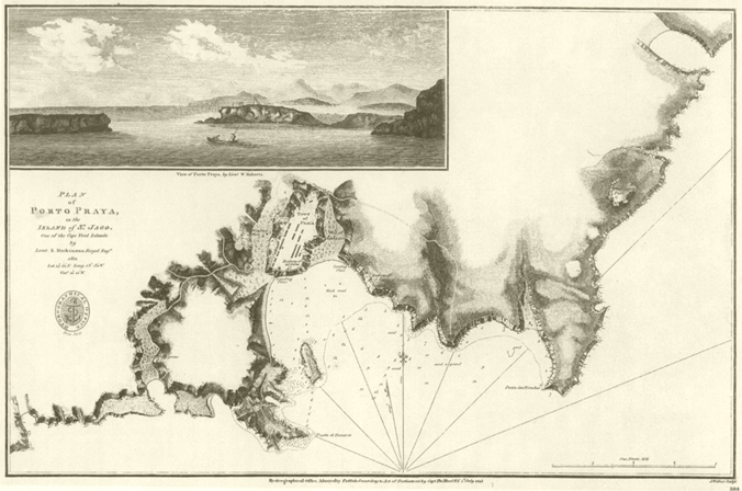
Figure 2. Plan of Porto Praya, including the 'I. of Quails', by Lieut. S. Dickinson. View of Porto Praya by Lieut. W. Roberts. British Admiralty Chart published in 1813. According to E. J. Dunn, Hydrographic Department, Ministry of Defence, this chart was current in the period 1832–36.

Figure 3. Section drawing at Quail Island.
yellow.red. or green clay. including the unaltered crystals of augite: these are all mingled & interlaced with great confusion: in other parts there are (4) dykes of a harder rock. which stand out from «better» resisting. the weather. the «rock» assumes a «transverse» columnar form: & from the cracks of such higher parts being filled with sand. I should think they must be of cotemporaneous origin. –
(Darwin's superscript numerals are keyed to notes regarding specimen numbers: (1) to specimens 52–58 and 64–69, (2) to specimens 48–52, (3) to specimens 58–59 and 68–69, and (4) to specimen 62, 'cotemporaneous dyke'.)
B The lowest(5) bed is of more «soily» indurated character than the other & contains a remarkable number of Turritellae. & some few other shells. Patellae. &c &c
(Darwin's superscript (5) refers to specimens 77–81 and 37–44. In the published version the bed is described as a 'soft, brown earthy tuff'.21)
C Several alternations. of coarse gravel. large rounded stones. & fine sand. – this contains a great variety of shells. – Cardium. Volutae a (1) rugged Ostreae in great profusion & adhering to the rocks on which they lived: patellae in vast numbers. – This is best seen on Eastern side of Island. & here 12 or 18 feet thick. on the West it is only a foot: on this side the gravel is cemented into a very hard conglomerate but as this process is now going on in the «coast of» island. perhaps it may «be» the work of the present day. –
(Darwin's superscript (1) refers to specimens 37–46, which include all the shells mentioned in the text.)
D This is a bed of very various characters[.] generally it is white «or grey» sand.(2) almost entirely formed of minute shells. & corallines. – The lower part of this is very remarkable. by being. almost composed of(3) concretionary masses of a white mineral: frequently being pisiform & having nucleus of some other rock <illeg.> this & inferior beds. often have the appearance of a wall built with mortar: the upper(4) parts of this & in near contact with superior Feldspathic «rock» become very hard: it is then white spotted with yellow. – At the South of island. the sand is cemented into a fine(5) sandstone. – In these beds, besides numerous small shells. I found. crabs & perfect bones of a Echini. –
(The superscripts refer to specimens: (1) 37–46, (2) 17–21, 27–34, (3) 25–26, (4) 21–24,
21 GSA, op. cit. (3), p. 3.
and (5) 74. For specimens listed under (1) Darwin noted 'The organic remains in these beds are certainly of a Tropical type. & as far as my knowledge goes. are the same as those of present day. – <I should think this old coast one of no great duration? –'. For specimens listed under (3) Darwin noted 'Curious white concretions often becoming pisiform. lower bed of white sand.' He also recorded the tests he performed on the specimens: 'Effervesces readily with Mur: Acid, gives precipitate with Oxalate of Ammonia. – Under Blowpipe becomes slowly caustic. & with [heat.?] Cobalt remains of a Violet colour. – Carbonate of Magnesia. (?) Carb of Lime'.)
E Above these beds as far as they extend & upon the Crystalline rocks (A) there is a horizontal cap of a hard (a)Feldspathic [underl. added pencil] rock. which has the appearance of Basalt: in some parts it has the appearance of plains of stratification. & «in» others of 5 sided columns, occasionally curved. – About a foot of the lower part is (b) carious & harsh. – The (c) upper is slightly so. & in parts is divided into large concen<tionary> tric balls. – 3 feet in diameter: giving a tesselated appearance to the rock. –(1) This formation varies from 6 to 20 feet in thickness. –
(Darwin's alphabetical footnotes refer to the following specimens: (a) 12–15 and 71, (b) 18–20, (c) 72–73. In his specimen notebook Darwin described numbers 12–15 as 'Poor Specimens'. Footnote (1) reads 'In places. this rock has entangled & fixed portions of lower augitic rock. –') Darwin then concluded his description of the sequence of rocks with a remark on structure:
The general height of Island is about 40 feet. but the beds in it often vary their relative height. in parts the grey sand is 30 feet above waters edge. in others close to it:(2) this is chiefly owing to dislocation of which there is a very marked one at (K)(3). –
('Dislocation' was underscored twice in pencil. Footnote (2) reads, 'The Eastern side of island is much more regular[.]'; footnote (3) reads, 'By this fault a small portion of grey sand on extremity of shore has been carried down[.]')
In reviewing Darwin's notes on Quail Island one can identify elements of his practice that remained constant throughout the voyage, and reflected well both on his early training and on the seriousness with which he approached his investigation. At the level of observation, he sought to establish the sequence of rocks in a given locale, as he did at Quail Island where the sequence was established for the entire island with rock samples collected for each distinct layer and where observations were summarized diagrammatically, as well as in prose. Darwin's focus on stratigraphy or, more loosely, bedding was consistent with the practice of colleagues at home, and of Adam Sedgwick and John Stevens Henslow who had overseen his most recent field studies.22 Additionally, structural features were of interest to British geologists, especially to Sedgwick, and Darwin's section
22 Secord, op. cit. (6); and for lucid characterizations of the practice of geology in Britain during the 1830s see M. J. S. Rudwick, The Great Devonian Controversy: the Shaping of Scientific Knowledge among Gentlemanly Specialists, Chicago, 1985, pp. 46–60 and J. Secord, Controversy in Victorian Geology: The Cambrian–Silurian Dispute, Princeton, 1986, pp. 24–38. For a broader formulation of many of the same topics see R. Laudan, From Mineralogy to Geology: The Foundations of a Science, 1650–1830, Chicago, 1987, chapter 7. On the primacy of stratigraphy in British geology see W. F. [S. F.] Cannon, 'The uniformitarian-catastrophist debate', Isis, (1960), 51, p. 39, and S. Herbert, 'Darwin the young geologist' in D. Kohn (ed.), The Darwinian Heritage, Princeton, 1985, pp. 485–9, 495–6.
drawing and notes on Quail Island show him observing within this tradition, recording line of dip (the rule-drawn diagonal line on the section) and a line of dislocation ('K').23 (In notes on other locales he also recorded the strike of strata.)
Darwin was also working within established practice in other respects. Characterizing rock type presumed the application of traditional mineralogical categories, and Darwin's notes on Quail Island show him applying these categories and also using the blowpipe and muriatic acid for chemical analysis. The presence of fossil shells is attended to, and joined with speculation regarding the relative age of the deposits: see Darwin's entry cited above for bed 'D'. Finally, in his geological work, Darwin remained within the boundaries of what would have been regarded as the common practice of the major British geologists of the 1830s. Thus he did not follow the lead of Alexander von Humboldt, from whom he took much in other respects, in pursuing the sorts of magnetic measurements that Humboldt favoured and that were in fact gathered assiduously and successfully by FitzRoy and other officers during the voyage.24 (Indeed the Beagle delayed its departure from São Tiago as the 'Captain is so much engaged with experiments on Magnetism…'.25) Despite his lack of direct involvement with the taking of magnetic measurements or their interpretation, Darwin did on occasion speculate as part of what John Cawood has termed the 'cosmical tradition' in magnetic researches.26
On the level of interpretation Darwin's geological notes, including those on Quail Island, are remarkably rich, fuller in theoretical material than, say, the field notes of Sedgwick or Murchison.27 Darwin was aware of his propensity to theorize and in writing to intimates lightly mocked his 'geological castles in the air' and his 'hypotheses' that 'if
23 On Sedgwick's structural approach to formations see Secord, op. cit. (22), pp. 57–68, and, on the orientation of Cambridge geologists towards mathematics see C. Smith, 'Geologists and mathematicians: the rise of physical geology' in P. M. Harman (ed.), Wranglers and Physicists: Studies in Cambridge Physics in the Nineteenth Century, Manchester, 1985, pp. 49–83.
24 Edward Sabine, a leader of the 'magnetic crusade' in Britain, characterized work done on the 1831–36 Beagle voyage as 'amongst the most important contributions to magnetical science' and the 'precursor of what British naval officers will accomplish for magnetism in the southern hemisphere'. E. Sabine, 'Report on the variations of the magnetic intensity observed at different points of the earth's surface', Rep. Seventh Meeting Brit. Assoc. Adv. Sci. [Liverpool 1837], (1838), 6, pp. 32, 33. FitzRoy had provided unpublished data on magnetic intensity gathered during the voyage to Sabine who incorporated it into his survey, which was relied on by C. F. Gauss. N. Reingold, 'Edward Sabine', DSB. FitzRoy published his data on magnetic variation in R. FitzRoy, op. cit. (7, 12), appendix, pp. 65–88. Regarding Humboldt's role in stimulating magnetical work see R. P. Multhauf and G. A. Good, A Brief History of Geomagnetism and a Catalog of the Collections of the National Museum of American History in Smithsonian Studies in History and Technology, (1987), 48, p. 11.
25 Diary, op. cit. (5), p. 33. David Stanbury informs me that FitzRoy pursued magnetical work primarily on his own initiative, government supported work having been assigned to the ill-fated HMS Chanticleer.
26 On the 'magnetic crusade' → J. Cawood, 'The magnetic crusade: science and politics in early Victorian Britain', Isis, (1979), 70, pp. 493–518, including p. 497, 'The cosmical tradition favored by Humboldt, Arago, and Sabine derived from an astronomical approach to geomagnetism and regarded terrestrial magnetism as just one of a number of interconnected telluric or earth forces which were responsible for the phenomena manifest in or on the earth.' For an instance of Darwin's speculation along these lines see his comment made soon after the voyage, 'In Cleavage discussion, state broadly indication of new law acting in certain directions predominantly, connection with magnetism &c counteracting gravity. – ' S. Herbert, ed., 'Notebook A' [hereafter 'A'] in Notebooks, op. cit. (17), A:62.
27 J. Secord, personal communication.
they were put into action but for one day, the world would come to an end. – '28 Much of his theorizing takes the form of responses to the current geological literature. But, much also stands alone as Darwin speculated on the origin and process of formation of the strata and land forms he viewed. Darwin's notes on Quail Island, and on São Tiago, contain examples of theorizing of both sorts. Whether in the form of debate with the writings of other geologists, or in direct comment on the immediate situation, Darwin's theoretically-oriented notes are strongly recursive: first thoughts are corrected and adjusted as the voyage progresses, thus creating within the entire group of notes from the voyage a pattern of saved and discarded elements. On the revisions side, for example, Darwin ended his notes on Quail Island with the comment 'I have drawn my pen through those parts which appear absurd. – '29 Similarly, in January 1833, upon 'Rereading this paper' (his earlier notes on Quail Island and São Tiago), Darwin wrote out a whole list of new comments and queries, which included the remark that he did not know 'whether Quail Island was formerly an island…', which had not seemed problematical earlier.30 Or, in addition to revising his notes, Darwin might place his observations in an expanded context, as with his observations at Cape Verde that funnelled into his reading of 'craters of elevation'.31
On matters of theory two issues stand out in Darwin's notes on Quail Island and São Tiago, the first elevation, the second diluvium. In both cases Darwin was entering upon questions that were still unsettled among English geologists. As such Darwin might refer to the questions obliquely, for their significance did not require elaboration.
Once Darwin had satisfied himself that elevation had occurred at Quail Island and São Tiago, he took up the question of its rate of occurrence by alluding to then current interpretations of the appearance of the Temple of Serapis at Pozzuoli near Naples. Of interest to geologists at this site were three marble pillars, presently standing on ground just below sea level, which were marked at their middle reaches by the boring of marine organisms. Regarding the interpretation of this monument, and, by inference, the nature of elevation at São Tiago, Darwin was challenging Charles Daubeny, and siding with Charles Lyell. Of the Temple of Serapis Daubeny had written in 1826:
Had such been the case [that the ground on which the Temple stands has undergone a depression of approximately 30 feet and subsequently an elevation of nearly that much], it is probable that not a single pillar of the temple would now retain its erect posture to attest the reality of these convulsions,…32
Since the pillars of the Temple had remained standing, Daubeny dismissed the change in level of the land as improbable, and the rise and fall of the sea equally so (as requiring a worldwide alteration), and concluded that some purely local cause, such as the damming up of water around the Temple, must be adduced to explain the present condition of the Temple. Four years later in the first volume of the Principles of Geology, Lyell took up the
28 Darwin to his sister Catherine, 8 November 1834, and to J. S. Henslow, 11 July 1831, in Correspondence, op. cit. (2), i, pp. 418–19, 125.
29 DAR 32.1:20.
30 DAR 32.1:36v.
31 Second, op. cit. (6); Correspondence, op. cit. (2), iii, pp. 54–5, 242.
32 C. Daubeny, A Description of Active and Extinct Volcanoes, London, 1826, p. 162. Darwin frequently cited this work while aboard the Beagle. Correspondence, op. cit. (2), i, pp. 557, 559.
question of the Temple of Serapis where Daubeny had left it. Both Daubeny and Lyell argued from the circumstance that those pillars of the Temple now standing above the sea bore the markings of the perforations of marine organisms, thus indicating that the Temple had at one time been submerged beneath the sea. Lyell implicitly accepted Daubeny's rejection of changed oceanic levels to account for the phenomenon. But Lyell rejected Daubeny's argument that elevation and subsidence of the land could not be involved. Lyell asserted that the pillars of the Temple could have sunk and risen again without having fallen, for
That buildings should have been submerged, and afterwards upheaved, without being entirely reduced to a heap of ruins, will appear no anomaly, when we recollect that in the year 1819, when the delta of the Indus sank down, the houses within the fort of Sindree subsided beneath the waves without being overthrown.33
Lyell's argument was thus not only in favour of elevation and subsidence as geological forces but also in favour of the belief that such forces could act so slowly and evenly that superficial features of the landscape were not disturbed.
At São Tiago Darwin rejected Daubeny's interpretation of the Temple of Serapis by arguing that
Dr. Daubeny when mentioning the present state of the temple of Serapis. doubts the possibility of a surface of country being raised without cracking buildings on it. – I feel sure at St Jago in some places a town might have been raised without injuring a house. – 34
By implication Darwin was also aligning himself in this remark with Lyell's gradualist image of the Temple of Serapis to account for the appearance of the Cape Verde Islands. Although the image did not account for all that Darwin would eventually assign to the role of elevation, it was a significant point at which to begin. Hence Darwin's comment concerning the Temple of Serapis, spontaneous and offhanded though it seems, corroborates his contemporary observation to Henslow regarding São Tiago that 'there are some facts on a large scale of upraised coast…that would interest Mr. Lyell', as well as his later comment in his Autobiography that 'I am proud to remember that the first place, namely St. Jago, in the Cape Verde Archipelago, which I geologised, convinced me of the infinite superiority of Lyell's views over those advocated in any other work known to me.'35
The second theoretical issue Darwin faced at the Cape Verde Islands concerned diluvium. He referred to a small covering of loose rock on the western side of Quail Island
33 Lyell, op. cit. (13), i, p. 455.
34 DAR 32.1:23v. The passage appears as a footnote to the passage on the facing page (24) where Darwin described his impression of the cliffs of São Tiago as seen from offshore and his judgement regarding the action of the force required to raise the cliffs:
When viewing from a distance an extent of cliffs. one is struck by the great force it must have required to have raised fields 2 or 3 miles broard [sic] of these rocks at least 50 feet. –…A considerable thickness of the lower crystalline rocks. must likewise have been elevated at the same time. – Taking this into consideration it is perfectly astonishing. that the force should have acted so uniformly that a spirit level with sights. proved the former beach to be as truly level as the present. –
This passage is continuous in sense with those from DAR 32.1:21–2 quoted in n. 19.
35 Darwin to J. S. Henslow, 18 May 1832, Correspondence, op. cit. (2), i, p. 236; Autobiography, op. cit. (1), p. 101.
as being 'part of the long disputed Diluvium'.36 The 'dispute' in question was over the origin of superficial deposits, particularly loose rocks and gravel. In the early 1820s the majority of members of what Sedgwick at points termed the 'The English school of geologists' supported the notion that superficial deposits could be divided into two kinds, 'diluvial' deposits characterized by 'great irregular masses of sand, loam, and coarse gravel, containing through its mass rounded blocks sometimes of enormous magnitude' and 'alluvial' deposits of 'comminuted gravel, silt, loam, and other materials'. The former deposits were presumed to have accumulated as a result of 'some great irregular inundation', the latter by the 'propelling force of…rivers' or 'successive partial inundations'.37 What gave emotional charge to the issue was that the 'great irregular inundation' was identified with, in Sedgwick's words, the 'waters of a general deluge' of the Noachian flood.38 The most publicly recognized spokesman for this interpretation of superficial deposits was William Buckland in his Reliquiae Diluvianae of 1823.39 However, the two men who determined Darwin's course of geological study at Cambridge, Sedgwick and Henslow, were also closely associated with the diluvial interpretation, Sedgwick in the papers of 1825 cited above and Henslow in an 1823 paper.40 It is therefore pertinent to consider how Darwin might have approached the subject of diluvium at the outset of the voyage.
Two circumstances that would seem to have affected Darwin's reception of diluvial theory were first, and more speculatively, his own immediate grounding in the tradition of scientific learning represented by his grandfather Erasmus and second, and more certainly, the very rapid change that diluvial theory was itself undergoing in the late 1820s and early 1830s, On the first count, Erasmus Darwin's work, though richly cosmological, did not integrate the Noachian flood into its images of the earth's history. Further, in the next generation, the geologist James Hall (1761–1832), whose work sprang from an interest in
36 DAR 32.1:20. The full passage, dated 17–18 January 1832, reads, 'I have not mentioned a small covering of diluvium on the Western side of the Island. – At first. I thought it merely debris from the upper feldspathic rocks. – but on examining I found numerous fragments of the lower augitic rocks. – it does not appear to be of marine origin although it is the most probable explanation. – It looks to me like a part of the long disputed Diluvium. –' Sometime later Darwin struck the passage 'it does not appear…Diluvium. –', along with several others in his notes on the island, adding, without elaboration (fol. 20), 'I have drawn my pen through those parts which appear absurd. –'
37 A. Sedgwick, 'On the origin of alluvial and diluvial deposits', Annals Phil. (1825) n.s., 9, p. 243.
38 A. Sedgwick, 'On diluvial formations'. Annals Phil. (1825), n.s., 10, p. 34.
39 W. Buckland, Reliquiae Diluvianae; or Observations on the Organic Remains Contained in Caves, Fissures, and Diluvial Gravel, and on Other Geological Phenomena, Attesting the Action of an Universal Deluge, London, 1823. William Buckland's work has been treated in two monographs: L. E. Page, 'The rise of diluvial theory in British geological thought', 1963 Ph.D. dissertation, University of Oklahoma, University Microfilm 64–215; and N. A. Rupke, The Great Chain of History: William Buckland and the English School of Geology (1814–1849), Oxford, 1983. Page recounted the basic sequence of events and provided ample quotation from the published sources. Drawing on unpublished material – Buckland's Oxford lectures being of greatest importance – Rupke supplied in addition a more interior sense of Buckland's motives, as well as an explanation for the origin and success of his revival of a narrowly focused diluvialism, namely that it represented an 'adjustment of modern, Cuvierian geology to the traditional system of classical education at Oxford' (p. 64). In contrast, Edinburgh University was 'not primarily an Anglican seminary like Oxbridge' (p. 22) and thus lent itself to a different sort of geology.
40 J. S. Henslow, 'On the deluge', Annals Phil. (1823), 6, pp. 344–9.
Huttonian geology compatible with Erasmus Darwin's own, published a diluvial theory accounting for the origin of superficial gravel and scored boulders that had no connection to the biblical deluge. This article, a masterpiece of scientific exposition, was known to a wide audience, being cited in one of the standard works of English geology, George Greenough's A Critical Examination of the First Principles of Geology (1819).41 Thus the tradition of interpretation represented in his own family, largely Huttonian, was consistent with contemporary continental views regarding the history of the earth.42 As James Secord has shown, the Huttonian tradition was available to Darwin at Edinburgh through the instruction of Thomas Charles Hope. On the second count, as Secord has also shown, Robert Jameson was revising his own diluvialism by 1826.43 Similarly it is of interest that Darwin's years at the University of Cambridge, from 1828 to 1831, coincided with a shift in opinion regarding diluvial theory among its geologists.
At Cambridge, shifting opinion in geology would have become known to Darwin first through John Stevens Henslow. Henslow had responded to Buckland's revived diluvialism with a corroborative contribution in 1823, wherein he argued for an astronomical and non-miraculous cause for the deluge. Thereafter he did not comment on the deluge explicitly, though various of his writings from the period suggest that questions regarding the interpretation of scripture were uppermost in his mind.44 By the mid-1820s Henslow's own scientific interests had centred on botany, however, and on geological matters he would have deferred to Adam Sedgwick.45 As holder of the Woodwardian chair in geology at Cambridge, and thus counterpart to Buckland who was reader in geology and mineralogy at Oxford, Sedgwick's opinion could be expected to carry weight. Fortunately Sedgwick's opinions can be dated. The apogee of his commitment to Buckland's diluvialism is represented by the two previously cited papers of 1825, which represented an original contribution to the theory as well as a defence of Buckland. Thereafter, Sedgwick's conviction waned, largely in response to his receipt of derisive comments from peers on the continent and to his exploration of new landscapes in the company of others less inclined towards Buckland's views. At the turn of the year 1826–27 Sedgwick spent six or seven weeks in Paris and during the following summer he geologized in Scotland with Roderick Murchison. As he recalled in a letter to Murchison written after the crisis had passed,
41 J. Hall, 'On the revolutions of the earth's surface', Trans. Roy. Soc. Edinb. (1815), 44, pp. 139–212. G. Greenough, A Critical Examination of the First Principles of Geology, London, 1819, pp. 151–5. Darwin had this book aboard ship (Correspondence, op. cit. (2), i, p. 560). For his later use of Hall's article see Notebooks, op. cit. (17, 26), A: 36, n. 4 and FitzRoy (ed.), op. cit. (7), iii [Journal and Remarks. 1832–1836, by C. Darwin], [volume also published as Journal of Researches into the Geology and Natural History of the Various Countries Visited by H.M.S. 'Beagle', Under the Command of Captain FitzRoy, R.N. from 1832 to 1836, London, 1839; hereafter JR], pp. 621–5.
42 R. Laudan, op. cit. (22), pp. 36–41, 110.
43 Secord, op. cit. (6), n. 10; 'Edinburgh Lamarckians: Robert Jameson and Robert E. Grant', J Hist. Biol. (1991), 24.
44 S. Herbert 'Between Genesis and geology: Darwin and some contemporaries in the 1820s and 1830s', in R. W. Davis and R. J. Helmstadter (eds.), Religion and Irreligion in Victorian England, London, forthcoming.
45 Darwin's late recollection that he had not attended Sedgwick's lectures in geology at the university is at variance with other evidence; see J. Secord, op. cit. (6), n. 28. Certainly Darwin knew something of the content of Sedgwick's lectures. After Darwin's death, J. M. Rodwell recalled Darwin saying of Sedgwick while at Cambridge, 'What a capital hand is Sedgewick [sic] for drawing large cheques upon the Bank of Time!' Correspondence, op. cit. (2), i, p. 125, n. 2.
If I have been converted in part from the diluvian theory…it was…by my own gradual improved experience, and by communicating with those about me. Perhaps I may date my change of mind (at least in part) from our journey in the Highlands [in 1827], where there are so many indications of local diluvial operations…. [Alexander von] Humboldt ridiculed [the doctrine] beyond measure when I met him in Paris. [Louis-Constant] Prévost lectured against it.46
More publicly, in 1830, in response to the arch antidiluvialism of the just published first volume of Lyell's Principles of Geology, Sedgwick expressed the belief that diluvial deposits were of varying dates.47 The next year he 'read my recantation' to his geological peers regarding his former adherence to Buckland's interpretation of diluvial deposits.48 In his university lectures Sedgwick also drew back from Buckland's reading of the diluvium. His printed lecture notes from 1821 refer to 'Diluvian Detritus'; in the 1832 and 1837 notes the same deposits are described as 'Ancient alluvion ("Diluvial detritus")'.49
It may seem ironic that the years of Darwin's presence at the university corresponded with the years of Sedgwick's declining adherence to the diluvial theory he had defended so strongly in 1825, but, if so, the seeming irony is perhaps best read as an indication of the rapidity of change within the field of geology. For Sedgwick in 1831 there remained a distinction between diluvial and alluvial deposits, but the connection between 'diluvium' and the Noachian flood had been dissolved. Thus when Darwin was actively pursuing the study of geology during his last terms at Cambridge, he would have encountered a diluvial theory separated from connection to the biblical flood.
This view is supported by Darwin's own contemporary records, for at no point in his geological notes or correspondence from the voyage does he connect diluvium with the Noachian flood. When Darwin used the term 'diluvium', he was using it in a restricted manner as referring to a distinct formation whose physical characteristics had been described by his own guides in the field at Cambridge. However, the question of origin of the formation, part of the 'long dispute', was still open, and Darwin's geological notes do suggest great interest on his part in superficial deposits, accompanied by a dramatic change in their interpretation. By the end of the voyage he regarded most superficial deposits as products of marine deposition rather than of any sort of inundation. As he became increasingly Lyellian in his views in the course of the voyage he became correspondingly less inclined to invoke overland rushes of water – debacles – to account for 'diluvial' formations. As he remarked late in the voyage, 'N.B. in general discussion introduce diluvium generally submarine.'50 In keeping with this shift in interpretation he moved away from uncritical use of the term diluvium over the course of the voyage, drawing a distinction between the formation itself and what it was 'called'. His change of mind and
46 J. W. Clark and T. K. Hughes, The Life and Letters of the Reverend Adam Sedgwick, 2 vols, Cambridge, 1890, i. p. 371; also i, pp. 270–4 on Sedgwick's stay in Paris, and i, chapter 8 on his travels with Murchison in the Highlands.
47 A. Sedgwick, Presidential Address (19 February 1830), Proc. Geol. Soc. Lond. (1826–33), 1, p. 191.
48 A. Sedgwick, Presidential Address (18 February 1831), Proc. Geol. Soc. Lond. (1826–33), 1, p. 313.
49 A. Sedgwick, A Syllabus of a Course of Lectures on Geology, Cambridge, 1821, p. 36; 2nd edn, 1832, p. 9; 3rd edn, 1837, p. 10. In 1833 Lyell conducted a frontal attack on the term diluvium (op. cit. (9), iii, glossary p. 67). Darwin used the term during the voyage but not later in print. Rupke, op. cit. (39), p. 88 lists some survivals of diluvial terminology in the 1830s.
50 Santiago Book, op. cit. (17), p. 28 (facing p. 27) in rear of notebook.
his self conscious distancing himself from what he perceived to be the standard view are explicit in his notes.51
The dispute over diluvium was of course not over. The issues it had raised, and temporarily joined, continued to be of the highest interest to geologists. History graded into archaeology and interest in human remains; debate continued as intensely as before on the origin of what had formerly been termed diluvial deposits. Eventually most of these deposits would be reinterpreted as glacial remains, a theory towards which Darwin was initially strongly antagonistic. But that part of the story, well told before, extends beyond the Beagle voyage.52
A SYNTHETIC ESSAY: 'ELEVATION OF PATAGONIA'
The next text I would like to treat is a synthetic essay of the sort Darwin inserted at several points into his ongoing run of geological notes. The essay is entitled 'Elevation of Patagonia' and dates from mid-1834, some time after the expedition up the Santa Cruz River, which ran from 18 April to 8 May, but before the Beagle had sailed far up the west coast of the continent.53 The essay was also written after Darwin had in hand the third
51 For an indication of Darwin's changing usage of the term diluvium see the following representative quotations from his geological notes: DAR 32.1:34 in 1832 at the Cape Verde Islands, 'great beds of diluvium'; DAR 32.1:68 in 1832 at Bahia Blanca, 'The whole country was elevated. – at this period «or later» the diluvium was deposited, which I have said probably owes its origin to a flood coming from the W in direction of the Andes. –'; DAR 32.1:71 in 1832 at Bahia Blanca, 'superficial gravels & caverns. – or as it is sometimes called diluvial formations. –'; DAR 34.1:64v in 1834 in a note entitled 'Elevations on coast of Patagonia', '…Valleys, …at S. Cruz How formed? sea or diluvial wave? –'; DAR 34.2:150 in 1834 at the Santa Cruz river, 'I suppose some would call it Diluvium'; DAR 35.1:216 in 1834 at Chiloe, 'On any other supposition (putting aside Diluvium)…'; DAR 36.1:435 in 1834 or (possibly) 1835 in Chile, 'The ultimate conclusion which I <draw> «have» come to – Is that primarily the line of elevation determines the figure of a Continent; secondarily that a gradually retreating ocean models the elevated points; smooths with so called Diluvium some of its asperities, determines the directions of the great slopes –'; DAR 36.1:459 in 1835 in Chile, 'Will not the arguments of De Luc &c about the quantity of detritus in <the> a mountain talus &c &c apply in most districts to <measure> «ascertain» the remoteness of that Epoch in <each case> «place of an» universal deluge?–'; DAR 37.1.675 in 1835 at Copiapó, 'From the description of the valleys in this line of coast, an extent of about 400 miles, the following conclusions appear to me inevitable. – That the sea, during a long & quiet residence deposited those masses of Shingle stratified with seams of sand & clay. which in Europe would be called Diluvium. '[underl. added pencil]; DAR 38.1:815 in 1836 near Sydney in the valley of the Nepean River, 'The present river could never have placed this gravel in its present position; it belongs to the substances called Diluvium; & which in this case probably was left by the retiring sea.' [underl. added pencil]; DAR 38.1:832 in 1836 of the forming of great valleys near Sydney, 'If the agency of Debacles be attempted to be brought into play; it must be remembered that the accumulations, called Diluvium, is in this country very infrequent…'.
52 For the debate regarding agencies of deposition, including identification of the agency of glaciers that resolved key points in the dispute see G. L. Davies, The Earth in Decay: A History of British Geomorphology, 1578–1878, New York, 1969, chapters 8, 9; Rupke, op. cit. (39), chapter 9; and R. J. Chorley, A. J. Dunn and R. P. Beckinsale, The History of the Study of Landforms, or the Development of Geomorphology, London, 1964, chapter 13. On Darwin's primary public engagement with the topic of superficial deposits see M. J. S. Rudwick, 'Darwin and Glen Roy: a "great failure" in scientific method?' Stud. Hist. Phi. Sci. (1974), 5, pp. 97–185; also S. Herbert, 'The logic of Darwin's discovery', 1968 Ph.D. dissertation, Brandeis University, University Microfilm 69–05446, pp. 23–32.
53 DAR 34.1:40–60. The title is written in pencil and, as the text is in ink, is presumably a later addition. Dating of the manuscript is approximate. From internal references (fol. 42) it is clear that Darwin had already completed the expedition up the Santa Cruz River but not yet travelled extensively in the Andes. See fol. 47 for the speculation, 'If on some future day I shall be able to prove that the West coast has been elevated within the same period…'. On 10 June 1834 the Beagle 'Sailed for last time from Tierra del Fuego', arriving on the west coast of South America via the Magdalen channel. Correspondence, op. cit. (2), i, p. 541.
volume of Lyell's Principles, which figures prominently in Darwin's discussion.54 'Elevation of Patagonia' is important for several reasons. It was written roughly half-way into the voyage, at the conclusion of Beagle's work on the eastern coast of South America. It thus represents the state of Darwin's opinion on the action of elevatory forces at an obvious and natural juncture. In content the essay suggests Darwin's developing interest in continental elevation. In tone it reflects its midway position, being both assertive to the point of challenging Lyell's authority and tentative and open-ended in its treatment of the question of the relation of elevation of the plains to that of the Andes and of retaining the lowering of sea level as at least a logically possible, though unlikely, explanation for the phenomena of the plains.55 Another interesting feature of the essay is that it shows Darwin working closely with officers of the Beagle in the activities of measuring the height and breadth of the plains of Patagonia, and of estimating the slope of the adjacent ocean floor. In no other task during the voyage was the integration of their labours as complete. For his part Darwin had carried with him on the voyage a set of aneroid barometers for, as he had written to FitzRoy while preparing for the voyage: 'Several great guns in the Scientific World have told me some points in geology to ascertain which entirely depend on their relative height.'56 On FitzRoy's part the charting of the coastline of Patagonia was at the heart of his mission as commander and surveyor, for as the hydrographer Beaufort had noted in his official memorandum of instructions 'To the southward of the Rio de la Plata, the real work of the survey will begin…'.57 While Darwin's concern was primarily with the interior and FitzRoy's with the coastline, their interests overlapped for FitzRoy was required as part of his survey to supply the 'perpendicular height of all remarkable hills and headlands', and Darwin took as his point of departure the height of the escarpments running along the coast.58 In addition, Darwin depended entirely on measurements taken
54 Another work to which Darwin made reference in the essay was William Whewell's 'paper on tides and currents', which he reminded himself to consult (DAR 34.1:40). Presumably this would have been W. Whewell, 'Essay towards a first approximation to a map of cotidal lines', Phil. Trans. Roy. Soc. Lond. (1833), pp. 147–236, including pp. 189–92 'On the tides of the South Atlantic'.
55 DAR 34.1:40v, 'From evidence drawn alone from these plains I do not know any proof that the land has risen in preference to the sea having subsided. – As «a» fall in the Atlantic would necessarily affect the «seas of the» whole world. – I think we may feel certain that no catastrophe has been so violent as to cause <a> «any great &» sudden subsidence <of> such as 100 feet. – Reason will be given for supposing that one set of plains was elevated at one period more than that number of feet. – Of course the weightiest argument against the «hypothesis of» the fall of sea. is simply that it is more improbable; it requires a greater amount of change. –'.
56 Darwin to R. FitzRoy, 10 October 1831, Correspondence, op. cit. (2), i, p. 175.
57 FitzRoy, op. cit. (8), ii, p. 26.
58 FitzRoy, op. cit. (8), ii, p. 34. The charts compiled from data gathered during the voyage are listed in Catalogue of Charts, Plans, Views, and Sailing Directions, &c., published by order of the Lords Commissioners of the Admiralty, London, 1852 (or other editions). Charts 1324, 1288, and 1284 are helpful as providing an overview of the Patagonian coastline. A comparison with an earlier chart will suggest the scale of FitzRoy's improvements. See the British version of a Spanish chart of 1798 (British Admiralty chart 1059 south; published by W. Faden, London, 1821). While some of the place names Darwin mentioned in 'Elevation of Patagonia' are obscure, they all appear in the above charts.

Figure 4. Heights of Patagonian plains.
by the ship's officers and men for estimating the slope of the sea bottom. The culminating event of the collaboration of Fitzroy and Darwin was the expedition up the Santa Cruz River, which provided Darwin with what he termed his 'best opportunity' of observing facts regarding the elevation of Patagonia.59 Finally, from the point of view of literary continuity, the essay 'Elevation of Patagonia' is of interest because it served as the foundation for Darwin's later treatments of the same subject in the Journal of Researches and the Geological Observations on South America. These published treatments will be touched on briefly following discussion of the unpublished manuscript.
In 'Elevation of Patagonia' Darwin's primary contention was that the southern plains had risen by successive elevations propelled by forces acting over a large area. His evidence was the succession of plains whose height had been measured by himself and by officers of the ship. As part of his essay Darwin drew a composite figure representing the height of these plains, those drawn connected having 'been seen close together, generally forming Escarpements'60 (Figure 4). Darwin did not label his sketch, but from his text their probable identity can be known. For the purposes of the sketch he provided round figures for several measurements. Reading from left to right the figures signify: 40′ –60′ plains near the River Chubut (40′ plains were also measured at Buenos Aires, 50′ plains at Santa Fé on the Paraná River); 100′ cliffs at St Joseph [Golfo San José], New Bay [Nuevo Gulf], (later Darwin referred to the coastline of La Plata as elevated to 100′61); plains at Port Desire/St George's Bay [Puerto Deseado/Golfo San Jorge] (60′ [100′ in text], 250′, 350′, 580′); plains at the Santa Cruz River and inland (350′, 710′, 840′); plains at Bird Island/St Julian [Isla del Pajaro (48° 44′ S.), San Julián] (580′, 950′, 350′, 100′); and an estimated plain of 1200′ at St George's Bay. The breadth as well as the height of these plains interested Darwin, and he reckoned the 580′ plain to extend over a distance of more than 200 miles, the 350′ plain over a distance of more than 550 miles, the 250′ plain even further,
59 DAR 34.1;48. For a reproduction of the chart of the river and its mouth see FitzRoy, op. cit. (8), ii, facing p. 339. Keynes suggested that FitzRoy's party probably came within a few miles of discovering Lago Argentino, out of which the river flows. Diary, op. cit. (5), p. 239. For reproductions of Conrad Martens's sketches of scenes from the expedition see R. Keynes (ed.), The 'Beagle' Record, Cambridge, 1979, pp. 200–13.
60 DAR 34.1:57. The figure has been traced from the original, which is in ink drawn over a partial sketch in pencil.
61 GSA, op. cit. (3), p. 18. Published figures for some of the plains differ from those contained in 'Elevation of Patagonia'; however, all but the 60′ plain at Port Desire/St George's Bay arc mentioned in the text.
and the 50′ plain over a 300 mile distance as measured in a north—south line in the Pampas.62
In addition to the height and breadth of the plains, Darwin was interested in the slope of the bottom of the sea adjacent to the Patagonian coastline, for if the slope of the sea bed were approximately that of the adjacent plains one might infer that the force elevating the land was acting concentrically with the globe. On the other hand, were the slope on the land far steeper than that beneath the sea, one might posit an elevatory force acting along the line of the Andes. Unfortunately, Darwin found only 'scanty' data on the slope of the sea bottom.63 His most complete measurements came from the ocean floor extending out from the Santa Cruz River. Here the slope of the sea bottom was considerably less than that on the land. However, Darwin distrusted these data since he believed the presence of the Falkland Islands might have made the bottom shoaler than it would have been otherwise. Thus, for the actual estimated slope (54 fathoms over a distance of 137 miles), he substituted a figure for the slope he believed more likely to have existed in the ancient sea (80 to 100 fathoms over the same distance). Working with a comparable estimate for the original slope of the land from the Andes to the head of the Santa Cruz River (100 fathoms over a distance of 160 miles), he concluded that if there was a tilt from the Andes it was very small, 'only 100 or 200 ft in a hundred miles'.64 However problematic his data and conjectural his premises, Darwin concluded in favour of elevations 'concentric with form of globe (or certainly nearly so)'.65
What then was the nature of these elevations? The key word in Darwin's interpretation is 'successive'; that is, he believed the elevations to have been identifiable and distinct rather than smoothly continuous. He formed his view by close scrutiny of the relation of two plains at Santa Cruz. The 355′ cliffs to the south of the anchorage, though appearing level to the eye, actually rose over a distance of six miles inland to a height of 463′, where the plain formed the base of a 710′ escarpment, most of the rise coming in the last half mile. Since Darwin could find no line of a former beach within this six mile expanse, he thought it probable that the 108′ rise represented a discrete event: 'I do not mean it is necessary that it rose in five minutes or a day. but in so short a time that no beach – no coast-line could be formed.'66 Reviewing all his data Darwin then concluded, '…I think we clearly prove 7 or 8 successive elevations;…'.67 (He did not, however, equate the existence of distinct plains with discrete elevations. Thus the 350′ plain was formed by steps, with evidence for
62 DAR 34.1:57–8.
63 DAR 34.1:44.
64 DAR 34.1:44. In an estimate based on actual measurements Darwin posited a slope of 1233′ (205.5 fathoms) in 160 miles over land at Santa Cruz, more than double the estimated slope in the ancient sea bottom (100 fathoms over 160 miles), and far greater than the estimated actual slope of the sea bottom (54 fathoms over 137 miles). However, the inland measurement Darwin thought 'doubtful by Lava occurring in the above interval'. He therefore added the conjecture, '…the highest plain <which> (not a very regular one) which I measured is 97 miles from Coast & 1416 ft high. Now this is only 516 ft higher than the 900 plains on coast (assumed 900 between 840 & 950): accordingly as 160 «miles» gives 100 Fathoms: 97 «miles» gives 363 «ft». – So that these plains are only 153 ft <abv> higher than would be expected with a concentric elevation. –'
65 DAR 34.1:59.
66 DAR 34.1:50v and continuing, 'Perhaps from analogy a <small> sudden rise is more probable. & (if granted) its retiring waters may (perhaps?) explain some of the valleys. –'
67 DAR 34.1:57.
some successive elevations lost, a point on which he cited Lyell.68) Darwin then drew the larger conclusion:
Considering how little of the coast was examined with geological views, I think it is quite astonishing the agreement in height <of> in the different series of plains widely apart. I feel quite convinced that the whole <part> <plains> «of the modern formations» of S. America from above C. Horn to near B. Blanca, «a distance of nearly 1200 miles» <rose> was <raised> formed into dry [land] and <elevated> «uplifted» to its present height by a succession of elevations which acted over the whole of this space with nearly an equal force.69
From the vast extent of this elevation Darwin drew an important conclusion regarding the source of the elevatory force. He asserted that the elevation of the plains required the '«gradual» expansion of [the?] central mass [of the earth]. – acting by intervals on the outer crust…', and he explicitly contrasted his own view with that of Lyell who had posited elevatory forces operating at relatively small distances beneath the surface of the crust.70
In 'Elevation of Patagonia' Darwin also discussed the date of elevation of the plains, not in numerical terms, but in the relative sense indicated by Sedgwick: 'As the historians of the natural world, we can describe the order of the events which are past;…but we define not the length of time during which they were elaborated…'.71 In dating the elevation of the plains Darwin relied on animal remains. His single most important fact was the prevalence of marine shells retaining their original colour and found up to a height of 400′ over a distance of nearly 800 miles from St Joseph (Golfo San José) in the north to St Sebastian (Cabo San Sebastián) in the south. He believed the retention of colour in the shells spoke to a recent date for the elevation of the plains. (He also identified a number of shells but did not attempt at this time to use the information in dating.) The similarity in height of a number of the plains also convinced him that their rise had been 'contemporaneous'.72 He believed this rise extended beyond the Patagonian plains to include the Pampas to the north and, very probably, the Andes to the west. He tied the date in the rise of the Pampas to that of the Patagonian plains using not shells, in which the Pampas were deficient, but what he believed was the identity between certain unspecified fossil bones found there with others found along a low, coastal, and hence recent plain in Patagonia. The Andes too, he suspected, were part of the 'contemporaneous' rise, though he made this point tentatively: 'If on some future day I shall be able to prove that the West coast has been elevated <to a…> within the same period. – it will almost render it
68 DAR 34.1:51, 40. Darwin supplied the volume number but not a page citation to the book, but the probable reference was to Lyell, op. cit. (9), iii, pp. 111–13.
69 DAR 34.1:58.
70 DAR 34.1:59. Regarding Lyell he wrote (fols. 58–9): 'lf my conclusion is granted (& in no other way I think can the coincidence in heights be accounted [for]), it appears to me, that the phenomenon of the elevation of strata is so grand, so uniform in its nature, that, the explanation offered by Mr Lyell of injection of Hypogene rocks is quite insufficient. – Can one imagine a mass of melted matter 600 miles in length <forcing> «lifting» up <wards> a great thickness of Strata to almost exactly the same height? –' Also see Lyell, op. cit. (9), iii, pp. 374–81. Lyell spoke of hypogene rocks originating from great depths (p. 380), but his hypothetical example for the source of Etnean lavas mentions only ten miles.
71 Sedgwick, op. cit. (47), p. 211.
72 DAR 34.1:47.
certain that the whole «S. part of» continent has <…> been elevated. –'73 Darwin concluded his treatment of the elevation of Patagonia by placing himself on the Lyellian end of the spectrum of contemporary geological opinion regarding the history of the earth:
As some authors have supposed the elevations of continents took place when the agents of change were in a state of greater activity, it appears to me a fact of high interest that <such> so large a part of <…> extremity of S. America has been uplifted in a period during which recent shells exposed to atmospherical change have retained their color [sic] and animal Nature.74
Darwin then added a thought jarring to the present-day reader. Expanding on a conjecture by FitzRoy, with whom he was then in frequent conversation, Darwin speculated that the recent date of the elevation of South America might account for the distribution of centres of ancient population on the continent.75
En route to publication Darwin's essay underwent revision. In neither the Journal of Researches nor the Geological Observations on South America was mention made of the interior of the earth, or of Lyell's and Darwin's divergent views on the subject. Nor was the dating of the elevation of the continent correlated with human history. In both publications very much more was made of the gravel deposits of Patagonia and their interpretation. Yet overall the treatment of the plains of Patagonia between manuscript and publications was continuous. In the Journal of Researches Darwin presented an 'imaginary section of the plains near the coast' rather than discussing actual plains; however, the elevations referred to in the diagram (580′, 350′, 250′, 100′) were clearly drawn from the more familiar plains (Figure 5).76 There was, however, one striking departure between the manuscript and the Journal. It pertained to the manner in which elevation had occurred. In the Journal he wrote:
At first I could only understand the grand covering of gravel, by the supposition of some epoch of extreme violence, and the successive lines of cliff, by as many great elevations…. Guided by the "Principles of Geology," I came to another, and I hope more satisfactory conclusion.77
He then proceeded to argue for elevations 'at a perfectly equable rate' with the cliffs being formed during periods of 'repose in the elevations': 'Accordingly as the repose was long, so would be the quantity of land consumed, and the consequent height of such cliffs.'78
73 DAR 34.1:47.
74 DAR 34.1:60.
75 DAR 34.1:60v: 'Conversing with Capt: FitzRoy, <…> concerning the recent elevation of the continent he suggested the following bold hypothesis: The number of distinct languages in T. del Fuego & <the difference of their habits from surrounding> «the similarity in physical structure» suggests an high antiquity to the race of the «se» Indians: – It seems a most strange fact, that any power could have induced a set of men to leave the <fertile> «immense &» <bountiful> «fertile» regions of temperate America & inhabit the miserable country of the South. – May we conjecture. that this migration took place. anterior to the last 2 or 3000 ft elevation; when the greater part of America <would be> «being» covered with the sea. <necessity> «want of food» might «well» compel small tribes to follow to the extremity the ridge of mountains:? May we venture to <enlarge> extend this idea – the lofty plains of Mexico & Peru. <would form fertile regions> «probably existed as dry land» at an immensely remote epoch. – Hence <have> «did» they not become the two centres of <civi> aboriginal civilization? –'
76 JR, op. cit. (41), pp. 201–2.
77 JR, op. cit. (41), p. 204.
78 JR, op. cit. (41), p. 205.
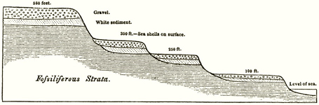
Figure 5. An imaginary section of the Patagonian plains near the coast.
Since Darwin's earlier view of elevations as discrete and successive was also formed in consultation with the Principles of Geology, one may speculate that his citation of the book in this revised context might have been only rhetorical, or have reflected a rereading of the work or, possibly, contact with its author.
In the Geological Observations on South America discussion of the elevation of the Patagonian plains occurs in the first chapter of the book. Placement of the subject reflects Darwin's decision to organize the work according to the age of deposits, with the most recent treated first. It also reflects his continuing confidence in the strength of his argument. As he wrote to Lyell in September 1844 after having written the first sixty pages of the book, 'The two first chapters, I think will be pretty good, on the elevation & great gravel terraces & plains of Patagonia & Chile & Peru. –'79 As one might expect, Darwin's treatment of the plains of Patagonia is smoother and more complete in this later version. The shells have now been described and dated by Darwin's French peer in South American exploration, A. C. V. D. d'Orbigny, with additional work by G. B. Sowerby.80 Presentation of the plains is polished. Five plains are figured, including the section of plains at the mouth of the Santa Cruz River shown below (Figure 6).81. Evidence for the similarity in height of plains across wide distances is presented.82 The subject of the Patagonian gravel, whose origin was briefly considered in 'Elevation of Patagonia', has now become of major interest.83 On a key question Darwin has retained the view, expressed in the Journal of Researches, that the rate of elevation is gradual and that cliffs are formed during periods of repose. In Geological Observations, however, Darwin is more tentative: 'in Patagonia
79 Darwin to C. Lyell, 1 September 1844, Correspondence, op. cit. (2), iii, p. 56. The first two chapters of GSA (note 3) were entitled 'On the Elevation of the Eastern Coast of South America', and 'On the Elevation of the Western Coast of South America'. The letter cited also reflects Darwin's ongoing difference with Orbigny over the history of the Patagonian deposits.
80 GSA, op. cit. (3), chapter 1; Correspondence, op. cit. (2), iii, pp. 143–5.
81 GSA, op, cit. (3). Sections of plains figured were those south of Nuevo Gulf (p. 6), in the Bay of St George (p. 6), at Port Desire (p. 7), at Port St Julian (p. 7), at the mouth of the Santa Cruz River (as shown, p. 8), and across terraces high up along the same river (p. 10).
82 GSA, op. cit. (3), pp. 14–16.
83 GSA, op. cit. (3), pp. 19–25. See also C. Darwin, 'On the distribution of the erratic boulders and on the contemporaneous unstratified deposits of South America', Trans. Geol. Soc. Lond. (1842) II, 6, pp. 415–31.
No. 5.—SECTION OF PLAINS AT THE MOUTH OF THE RIO SANTA CRUZ.
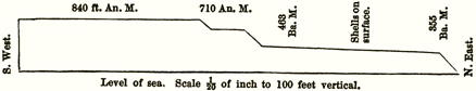
Figure 6. Section of plains at the mouth of the Santa Cruz River. 'An. M.' stands for angular or trigonometrical measurement, 'Ba. M.' for barometrical measurement.
the movement may have been by considerable starts, but much more probably slow and quiet'.84 Interestingly, in his book Darwin did not forget the 108′ rise at Santa Cruz to which he had devoted attention in 'Elevation of Patagonia' ('I particularly looked out for ridges in crossing this plain,…but I could not see any traces of such.…'.85) even while he left behind his initial interpretation of that rise as representing a single elevatory movement.
LATER MANUSCRIPTS
The last group of manuscripts I should like to consider date from the last fifteen months of the voyage. They all point towards publication and are critical to an understanding of Darwin's posture as a prospective author. These manuscripts are complex, and their dates cannot be firmly established in every case since Darwin was then in the business of rewriting. Explication of the full contents of the manuscripts will not be undertaken here. Even so their importance in the scheme of Darwin's geological work can be indicated.
The first of these texts derives from Darwin's last months in South America and is entitled 'Recapitulation and concluding remarks'. The title refers to the opening sentence of the text: 'Before finally leaving the shores of South America I will recapitulate those conclusions and facts which appear to me to be most worthy of attention.'86 The
84 GSA, op. cit. (3), p. 18.
85 GSA, op. cit. (3), p. 9 and, for further comment on the rise, p. 18. In a pencilled note on the first page of 'Elevation of Patagonia' Darwin remarked 'All used' except the theory of gravel plains on p. 8 of the manuscript, which contains his initial interpretation of the 108' rise at Santa Cruz.
86 DAR 41, no library foliation. Syms Covington, Darwin's servant, copied out the text. Darwin corrected Covington's copy in his own hand and, later, added numerous cross-references and notes to the whole. The manuscript is not dated nor has Darwin's original draft survived. Covington's fair copy was done on 'J. Whatman 1834' paper that came into Darwin's possession in early April or early May 1836. (P. R. Sloan, 'Darwin's invertebrate program, 1826–1836: Preconditions for transformism', in Kohn, op. cit. (22), pp. 118–19, n. 58). However, there is internal evidence suggesting the likelihood of an earlier date than 1836 for a first draft. The opening phrase of the text can probably be taken at face value. 'Before finally leaving the shores of South America…' would correspond to the period from 19 July to 6 September 1835 when Darwin was at Callao and Lima. Correspondence, op. cit. (2), i, p. 541, and see pp. 461 and 463 for similar locutions. Further, one emendation does argue against an 1836 dating for a first draft. It appears on fol. 4v and refers to the 'coral paper' of late 1835. (See notes 18, 109). If the 'coral paper' were already in existence at the time the draft for the 'Recapitulation' was written, it probably would have been referred to in the original text rather than appearing as an emendation.
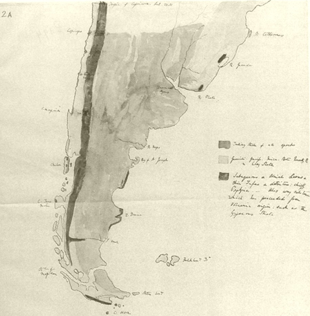
Figure 7. Darwin's hand-drawn and coloured map of southern South America. The key reads (from top to bottom); 'Tertiary Strata of all Epochs'; 'Granite. Gneiss. Mica. Slate. Quartz R & Clay Slate'; 'Subaqueous & Aerial Lavas & thin Tufas & detritus: chiefly Porphyries. – Also any substance which has proceeded from Volcanic origin: such as the Gypseous Strata'.
'Recapitulation' contains literary indications that suggest Darwin wrote it with future readers in mind, as well as for his own benefit. It is polished in appearance, Darwin having had his servant copy it out in a fair hand; at one point in the text space was left for citations from 'various Authorities' supporting Darwin's view of elevation of the Americas; and the text closes with a rhetorical peroration worthy of Humboldt: '…in laying the foundation of South America, Nature chose a simple plan – but upon that basis she has raised a magnificent structure!'87 In short, this 'geological memorandum' – Darwin's term – was moving towards publication.88
In the 'Recapitulation' Darwin summarized his geological work in South America, citing with approval previous work done by Humboldt and acknowledging his own Huttonian heritage. In the first half of the essay he reviewed the principal divisions of the formations of the sections of the Cordillera he had visisted.89 A hand-drawn and coloured map of the southern portion of the continent is also included with the essay (Figure 7).90 Its generality suggests a similarly summary and schematic approach.
In the second half of the essay Darwin took up the history of the development of the Cordillera and, with that, the subject of continental elevation. In 1834 in 'Elevation of Patagonia' he had argued for the elevation of the eastern plains of the continent and had expressed interest in studying the Andes in relation to that elevation. In the later 'Recapitulation' he broadened his view of elevation to include the Andes: 'in the Cordillera the whole of the present elevation above the sea is owing to a gradual and horizontal upheaval'.91 (In context 'gradual' is to be read as 'slow, prolonged, and perhaps scarcely sensible' rather than as occurring at a constant rate over time; 'horizontal' is used in contradistinction to 'angular'.92) In favour of this view he pointed to the equability of the basins situated in the summits of the Andes, as Titicaca, to the great Mexican platform, and especially to the equability of the Patagonian plains.93 Thus he came at the Andes from
87 DAR 41: 'Recapitulation', fols. 21, 29.
88 Charles to Catherine Darwin, 31 May 1835, Correspondence, op. cit. (2), i, p. 449: 'I am lucky in having plenty of occupation for the Sea part, in writing up my journal & Geological memoranda. – I have already got two books of rough notes. –'.
89 DAR 41, 'Recapitulation' fols. 1–14 discuss the Cordillera. Darwin organized the formations he observed in central and northern Chile into five principal divisions: granitic, crystalline slaty rocks, porphyritic breccia, and the gypseous and supergypseous formations.
90 The map is a separate sheet of tracing paper attached to the verso of fol. 1 of 'Recapitulation'. The date of the map is not certain, but its generality and placement suggest that it was roughly contemporary with the essay.
91 DAR 41: 'Recapitulation', fol. 15.
92 DAR 41: 'Recapitulation', fols. 16, 15. In fols. 14–19 the cross-currents and contradictory elements in Darwin's thinking about elevation are apparent. Thus while maintaining a gradualist outlook, he hypothesized a dramatic history for the Cordillera beginning with 'an epoch of excessive volcanic eruptions which has never since been nearly equalled' (fol. 14). Similarly, he sought to allow for instances of angular movement within a general picture of horizontal elevation (fol. 15).
93 DAR 41: 'Recapitulation', fol. 15, 'I conceive these views are in perfect conformity with the existence of those level remarkable basins, situated on the summit of the Andes. We may instance – Titicaca – Cuenca elevated 1350 toises – the valley of Quito from 1340 to 1490 toises – and the grand Mexican platform which between 19° and 24 ½° of latitude, remains constantly at the height of 950 to 1200 toises' (Humboldt, Personal Narrative, Vol. VI, Part II [1826:162]). 'Are not the strata in these plains horizontal? Can they all be thought lacustrine. –?' Also fol. 19: 'That the continental elevation is a phenomenon intimately connected with the rise in mass of the Andes, I think no one will dispute. – In Patagonia, within the recent period I have shown that its influence has been felt on the whole coast at the distance of 2 to 300 miles…. In Patagonia we have proofs that the coast has been elevated in a horizontal manner to a height of from 300 to 400 feet; and it may be assumed that there is no part which has not risen.'
the point of view of the plains. However, his work in the Andes did strengthen his general argument for elevation as the explanatory agent. Formerly he had allowed that the subsidence of the sea might have produced the effects he had seen in Patagonia.94 By 1835–36, with his view of mountain-building set firmly in the context of continental elevation, he could write in the 'Recapitulation':
The Andes and their accumulated detritus, together with this one great bed of crystalline rocks compose South America. – The whole has been raised from beneath the ocean into dry land by the action of one connected force.95
The key phrase here is 'one connected force'. In points he was later to expand, he argued that earthquakes and elevatory movements 'are so intimately connected, that if one is part of a regular series the other probably will obey similar laws'.96 He adopted a similar view of volcanic activity.97 The force is that he termed a 'gradual movement of the internal fluid mass' of the earth's interior, a view consistent with that taken in the essay on Patagonia, though not yet quite the thin crust model of the earth he was later to adopt.98 Interestingly, in the 'Recapitulation' Darwin did not make much of the elevatory effect of the Concepción earthquake of 20 February 1835, which he was later to do, presumably since the elevation observed did not fit the model for elevatory action he then held. The earthquake had produced higher elevation on the offshore island of Santa Maria than on the mainland. At the time of writing the 'Recapitulation' Darwin was positing the notion of elevation occurring as a curved enlargement of the earth's crust. If the elevatory movement were centred on the continent, this ought to have produced greater elevation inland than offshore.99
94 DAR 34.1:40, 42.
95 DAR 41: 'Recapitulation', fol. 29. The ideas presented here were seminal to the paper published most fully as C. Darwin, 'On the connexion of certain volcanic phenomena in South America; and on the formation of mountain chains and volcanos, as the effect of the same power by which continents are elevated', Trans. Geol. Soc. Lond. (1840) II, pt. 3, 5, pp. 601–31. For analysis of this paper and its reception see F. H. T. Rhodes, pp. 200–26, this volume.
96 DAR 41: 'Recapitulation', fol. 20.
97 DAR 41, 'Recapitulation', fol. 11 on the simultaneity of volcanic eruptions over large areas, also fol. 24 on volcanic eruptions as 'mere accidents, consequent on a more complete rupture of the strata,…accidents which happened during the periods, when that far more important phenomenon of injection determined the lines of elevation'.
98 DAR 41, 'Recapitulation', fol. 22, On Darwin's later development of the thin crust model see RN: 131, 154, op. cit. (17); A: 77–9, 114, 133, 136, 147, op. cit. (17, 26).
99 DAR 41, 'Recapitulation', fol. 18, 'I have called the gradual rise an horizontal upheaval. – Speaking with accuracy, the more probable movement is that of a curved enlargement of a narrow space of the superficies of the globe.' Also fol. 19, 'It is stated that in the Valparaiso earthquake of 1822, the land at the distance of 5 or 6 miles inshore, rose in the proportion of three to one, to that on the coast. On the other hand, it must be confessed, that in 1835 at Concepción, the rise of the Island of St Mary was greater than on the neighbouring mainland'. On the significance of the Concepción earthquake to Darwin and to Lyell see S. Herbert, 'Les divergences entre Darwin et Lyell sur quelques questions géologiques' in Y. Conry (ed.), De Darwin au Darwinisme: Science et idéologie, Paris, 1983, pp. 70–1.
A second and related essay from the latter part of the voyage was entitled 'Cleavage'.100 In it Darwin summarized his work on rock cleavage in South America. As he wrote by way of introduction, 'In my geological account of each district I have described all the facts respecting the <m…> Cleavage & Stratification of the rocks & likewise the more obvious conclusions which might be drawn in each particular case. – I will now take a general review of the whole phenomenon as seen in S. America. –101 As the essay entitled 'Recapitulation' with its emphasis on elevation reflected Darwin's tie to the tradition of Hutton and Lyell, so that entitled 'Cleavage' reflected his indebtedness to his study of structural geology under Henslow and Sedgwick. Secord has shown that Sedgwick was particularly interested in cementing a distinction between bedding, or stratification, and slaty cleavage, a distinction drawn informally in the 1820s by British geologists.102 It was therefore consistent with his earlier training that Darwin would open his essay on 'Cleavage' by defining the terms stratification, cleavage, and fissures:
By the term Stratification I mean those planes of division (resulting from <some> changes of circumstances,) which occur in matter, that has been deposited beneath <the sea> «water» & which <particles> «matter» was <successively> arranged «in an undisturbed manner» by the attraction of Gravity. –
By cleavage, a fissile structure. – The laminae not being necessarily parallel to the plane of Stratification. –
By Fissures, planes which are seen in laminated Stratified & non-Stratified rocks: – These when they occur in the two first cases are recognized as of a different nature….103
Darwin followed out these distinctions in the essay by considering the instances of rock cleavage, as opposed to stratification, that he had recorded as present in South America, supplementing his own observations with those of others.
The second source on which Darwin drew for his essay on 'Cleavage' was the discussion of 'loxodromism' in Humboldt's Personal Narrative. Humboldt had written,
…there exists in no hemisphere a general and absolute uniformity of direction, but that in regions of very considerable extent, sometimes on several thousand square leagues, we observe that the direction, and still more rarely the inclination, has been determined by a system of particular forces. We discover at great distances, a parallelism (loxodromism), a direction, of which the type is manifest amidst partial perturbations, and which often remains the same in primitive and transition soils.104
Darwin used Humboldt's notion of loxodromism to organize his discussion of cleavage.
100 DAR 41, 'Cleavage'. Sulloway (op. cit. (17), pp. 375–6, n. 15) has suggested a May 1836 date for the opening pages.
101 DAR 41, 'Cleavage', fol. 2.
102 Secord, op. cit. (22), pp. 58–9; op. cit. (6), Figure 6. See A. Sedgwick, 'Remarks on the structure of large mineral masses, and especially on the chemical changes produced in the aggregation of stratified rocks during different periods after their deposition', Trans. Geol. Soc. Lond. (1835), II, 3, pp. 461–86. Presumably this was the paper Darwin cited in an annotation on fol. 1 of 'Cleavage': 'Study Sedgwicks paper on Cleavage Geolog Transacts'. Also see the relevant entries in J. Challinor, A Dictionary of Geology, 5th edn, Cardiff, 1978.
103 DAR 41, 'Cleavage', fol. 1. See also DAR 32.2: 111–117. Darwin probably opened his essay with definitions to counter what he called (fol. 36) the 'doubt & confusion' exhibited in 'On Stratification' in Greenough, op. cit. (41), pp. 1–90.
104 Humboldt, op. cit. (13), vi, pp. 590–1. The passage is heavily scored in Darwin's copy of the work held at CUL.
The appeal of the concept of loxodromism lay in its recognition of the operation of large-scale forces affecting rocks over regions of great geographical extent. Humboldt had recorded the presence of loxodromism in the equatorial areas of South America he had visited. Darwin extended Humboldt's work southward. Integrating some of his own work with that of Humboldt he wrote, 'Justly to appreciate the importance of this subject, it is necessary to bear in mind, that the Area of which we are speaking, extends from 12° North. nearly to 35° South Latitude; a space of 2800 miles. – Conclusions drawn from so vast a territory become at once applicable to the Geology of the Whole Globe. –'105 Darwin speculated with regard to forces that might have produced identical cleavages in rocks extending over large areas. He believed them similar to forces producing metamorphism and elevation, though his comments were suggestive in tone rather than absolute. He included among the possible forces those of chemical attraction, and of electricity ('Do currents of Electricity flow…for long periods in certain directions, deep within the earth?')106 In the end, however, he left the question open, while asserting an 'intimate connection' among lines of metamorphic action and cleavage.107 Much of the material developed in the essay on 'Cleavage' eventually found its way into a chapter of the Geological Observations on South America.108
The next text of interest is 'Coral Islands'. Unlike the other geological manuscripts from the voyage discussed thus far, it exists in published form. In 1962, soon after the bulk of Darwin's manuscripts became readily accessible to scholars, D. R. Stoddart, an authority on reefs, published an edition of the text.109 The attention directed to this manuscript, especially when compared with the inattention accompanying other of Darwin's geological manuscripts, reflects the ongoing importance of Darwin's theory of the origin and distribution of coral reefs. As Stoddart and others have shown, Darwin's theory gained a favourable hearing in certain quarters immediately upon his return to England and served thereafter as a point of departure for further research.110 While the literature on these topics is extensive, for the purpose of considering Darwin as a prospective author I should like merely to underline certain aspects of his experience during the voyage and to add one piece of documentary evidence to its interpretation.
105 DAR 41, 'Cleavage', fols. 12–13.
106 DAR 41, 'Cleavage', fol. 35.
107 DAR 41, 'Cleavage', fols. 32, 33; also DAR 32.2: 115v, the added comment, 'From other observations I now consider it as established that there is some physical connection between lines of Elevation. metamorphic action & cleavage.'
108 GSA, op. cit. (3), chapter 6. Also C. Darwin, 'The geology of the Falkland Islands', Quart. J. Geol. Soc. Lond. (1846), 2, pp. 267–74.
109 CI, op. cit. (18). Darwin's original draft is dated 1835 and presumably would have been written in the interval between 26 November 1835, when the ship departed Tahiti, and 21 December, when the ship arrived at New Zealand.
110 On Lyell's immediately favourable response to Darwin's theory see D. R. Stoddart, 'Darwin, Lyell, and the geological significance of coral reefs', BJHS. (1976), 9, pp. 211–12; on Lyell's discomfort with regard to the large-scale subsidence required by Darwin's theory see Herbert, op. cit. (99), pp. 72–6. On an important early attempt to confirm Darwin's theory by deep boring a reef see R. MacLeod, 'Imperial reflections in the Southern seas: the Funafuti expeditions, 1896–1904', in R. MacLeod and P. F. Rehbock (eds.), Nature in its Greatest Extent: Western Science in the Pacific, Honolulu, 1988, pp. 181–91. For current views organized from an historical perspective see J. A. Steers and D. R. Stoddart, 'The origin of fringing reefs, barrier reefs and atolls', in O. A. Jones and R. Endean (eds.), Biology and Geology of Coral Reefs, 4 vols., New York, 1977, iv, pp. 21–57.
In a sense the subject of coral reefs was Darwin's only direct assignment as a geological author. Beaufort's memorandum of instructions for the voyage was unusually detailed regarding the inspection of coral reefs.111 Extending this point, advance notice of the voyage in the Athenaeum characterized proposed work on reefs as 'the most interesting part of the Beagle' s survey' affording 'many points for investigation of a scientific nature beyond the mere occupation of the surveyor'.112 As the only man with geological training aboard ship, the scientific aspects of the subject would be expected to devolve on Darwin. Still, Darwin does not seem to have taken it in hand until 1835, when the Pacific itinerary was close upon him. None the less, he arrived at the question at a propitious moment. During the preceding decade the question of the origin of coral reefs had been transformed into something like a set piece following the determination of a key parameter regarding the growth of reefs. The French naturalists J. R. Quoy and J. P. Gaimard had observed that organisms forming coral reefs operate at relatively shallow depths beneath the surface of the water.113 This new finding formed the basis of assessments of reef formation made by H. T. De la Beche, F. W. Beechey, and Lyell.114 As Beechey put it, 'The general opinion now is, that they have their foundations upon submarine mountains, or upon extinguished volcanoes, which are not more than four or five hundred feet immersed in the ocean; and that their shape depends upon the figure of the base whence they spring.'115 This was the legacy of interpretation Darwin inherited from previous authors. However, when he took up the problem, he also brought with him an imagination shaped by his own recent experiences in South America. He held before his mind's eye a vision of a rising continent shaped by the sea during its elevation.
Frederick Burkhardt has recently published evidence from the 'Santiago Book' confirming Darwin's statement in his Autobiography that he thought out his theory of the
111 Beaufort as cited in FitzRoy, op. cit. (8), ii, p. 38,
An exact geological map of the whole [coral] island should be constructed, showing its form, the greatest height to which the solid coral has risen, as well as that to which the fragments appear to have been forced. The slope of its sides should be carefully measured in different places, and particularly on the external face, by a series of soundings,…. A modern and very plausible theory has been put forward, that these wonderful formations, instead of ascending from the bottom of the sea, have been raised from the summits of extinct volcanoes; and therefore the nature of the bottom at each of these soundings should be noted, and every means exerted that ingenuity can devise of discovering at what depth the coral formation begins, and of what materials the substratum on which it rests is composed. The shape, slope, and elevation of the coral knolls in the lagoon would also help the investigation; and no circumstances should be neglected which can render an account of the general structure clear and perspicuous.
FitzRoy did comment on coral formations (chapter 22, 26) but referred to Darwin the question of the depth at which coral formation begins (p. 634) and, by implication, left the larger questions regarding reefs to him as well.
112 Athenaeum, (24 December 1831), 24, no. 217, p. 834.
113 J. R. Quoy and J. P. Gaimard's publications of 1824 and 1825 as cited in Stoddart, op. cit. (110), n. 19, p. 214.
114 H. T. De la Beche, A Geological Manual, London, 1831, pp. 140–3. F. W. Beechey, Narrative of a Voyage to the Pacific and Beering's Strait,…in His Majesty's Ship Blossom…in the Years 1825, 26, 27, 28, Philadelphia, 1832, pp. 159–70. Lyell, op. cit. (9), ii, pp. 283–301. These were the editions Darwin had on board. Correspondence, op. cit. (2), i, pp. 558–66. The London edition of Beechey had been published in 1831. De la Beche and Beechey, writing independently, both accepted Quoy and Gaimard's findings. Lyell built on their views, relying particularly on the navigator Beechey for descriptions of reefs.
115 Beechey, op. cit. (114), p. 169. Beechey was also aware of the difficulties of the 'general opinion'.
origin of coral reefs while still in South America.116 Although not Darwin's 'whole' theory as he said, its essential element linking coral reefs to a subsiding ocean floor is clearly present in the 'Santiago Book': 'As in Pacific a Corall bed. forming as land sunk…'.117 Again confirming the autobiographical account these notes show Darwin replacing in his imagination the 'continued deposition of sediment' by the 'upward growth of coral', for in the 'Santiago Book' he contrasted conglomerates, formed with 'bottom <land> coming near the surface', and calcareous deposits formed with 'the land sinking'.118
Darwin's next comments on reef formation, hitherto unremarked, occur in his notes for the Galápagos Islands. The Beagle stopped in the islands from 15 September to 20 October 1835, and the bulk of the notes in question appear to have been written between the date of departure from the Gal´pagos and 15 November, the date of arrival at Tahiti. In these notes Darwin tested the received notion of reef formation against his observations at the Galápagos Islands. Interestingly, his first points were made against himself. He noted that sixteen craters of 'sandstone' he observed at the Galápagos were like lagoon islands (atolls) in being raised more on one side than the other. He did not regard the parallel between these craters and atolls as exact but remarked 'I am so much the more bound to point out their coincidence, as I am no believer in the theory of Lagoon Islds. being [illeg.] on the circular ridges of submarine craters. – '119 He then drew attention to another circumstance at the Galápagos favouring the received explanation for the origin of coral atolls:
There is another circumstance connected with this subject, which is of some interest. Five of the great Volcanic mounds of Albemarle & Narborough Is1ds. which are surmounted by Craters having a diameter of between two & three miles, appear to the eye to be of an equal elevation. Three have been measured by angular observations: two in Albemarle Isd. are respectively 3720 & 3730 ft. & that of Narborough Isd. 3720 ft: high. – Inspecting the chart, one is tempted to exclaim; on such foundations ready placed at an equal height, the Lithophytes. might soon raise to the surface, their circular ridges of Coral rock. –120
Clearly the communality in height of the three craters encouraged speculation along the lines of the received opinion, against which Darwin had already positioned himself. The next topic regarding reef formation that Darwin took up in his Galápagos notes was neutral as between the received theory and his own. It pertained to the absence of coral reefs at
116 F. Burkhardt, 'Darwin's early notes on coral reef formation', Earth Sciences History, (1984), 3, pp. 160–3; reprinted in Correspondence, op. cit. (2), i, pp. 567–71. Nora Barlow referred to the entries on reefs in the notebook but did not quote them. See Barlow, op. cit. (12), pp. 243–4, and CI, op. cit. (24), p. 4, n. 8. On the relation between entries in the notebook and in 'Coral Islands' see F. Sulloway, op. cit. (17), pp. 367–81.
117 Correspondence, op. cit. (2, 140), i, p. 568. Autobiography, op. cit. (1), p. 98, '…for the whole theory was thought out on the west coast of S. America…'.
118 Autobiography, op. cit. (1), p. 99. Correspondence, op. cit. (2, 140), i, p. 568. See also W. Montgomery, 'Charles Darwin's theory of coral reefs and the problem of the chalk', Earth Sciences History, (1988), 7, pp. 11–120.
119 DAR 37.2:791. In JR, op. cit. (41), p. 453, the craters are described as being of volcanic sandstone; in VI, op. cit. (3), pp. 113–14 the craters are treated in detail and described as being formed of tuff. Darwin was the first to describe these craters, now termed tuff cones, and to connect their lowered southern lips with the action of waves formed by the prevailing winds. Also see A. R. McBirney and H. Williams, 'Geology and petrology of the Galápagos Islands', Geol. Soc. Am. Memoir, (1969), 118, p. 3.
120 DAR 37.2:791v.
the Galápagos Islands. He considered the possibility that the quantity of calcareous matter was deficient in the region, but his primary suggestion, for which he credited FitzRoy, was that the sea surrounding the islands was too cold for reef-building corals, 'a tribe of Animals, which seem…only to flourish where the heat is intense. – '.121 To this remark he attached a long entry, part of which was added after the Beagle had visited Tahiti, in which he recorded sea temperatures from the 'Weather Journal' kept aboard ship.122
There are no comments on coral reefs in the regular series of notes on Tahiti. Darwin's rich yield from Tahiti, in regard to his theory of reefs, was rather deposited in the essay 'Coral Islands'. In the essay Darwin recorded his new solution to the problem that had still vexed him at the Galápagos Islands: the origin of coral atolls. This solution linked the presence of volcanic islands encircled by reefs with the formation of atolls. In a well-phrased description of a moment of discovery Darwin wrote of his reasoning when viewing the coral framed island of Ei Meo (Moorea) from the heights of Tahiti: '…I was forcibly struck with this opinion. – The mountains abruptly rise out of a glassy lake, which is separated on all sides, by a narrow defined line of breakers, from the open sea. – Remove the central group of mountains, & there remains a Lagoon Isd. – '123 Darwin imagined the mountains being removed by subsidence of the ocean floor, the reef maintaining itself by upward growth.
The essay 'Coral Islands' also provides evidence of Darwin's assault on the literature respecting coral reefs, which was to a considerable extent available on board ship.124 In the essay Darwin attempted to integrate previous work with his own insights. Finally, Darwin came full circle in his essay by returning to the vision that had brought him to his new interpretation of coral reef formation: elevation in South America balanced by subsidence in the Pacific Ocean basin. In turn the two essays – 'Recapitulation and concluding remarks' and 'Coral Islands' – represent the yin and yang of a greater unity. The closing paragraph of 'Coral Islands' draws attention to this relation:
Before finally concluding this subject, I may remark that the general horizontal uplifting which I have proved has & is now raising upwards the greater part of S. America & as it would appear likewise of N. America, would of necessity be compensated by an equal subsidence in some other part of the world. – Does not the great extent of the Northern & Southern Pacifick include this corresponding Area? –125
Robert Edward Alison, a resident of Valparaiso with whom Darwin had conversed on geological topics, had written to him on 25 June 1835, 'I wish much to hear of your report respecting the islands in the Pacific, and it will be curious if you find a sinking of the land there, & a rising here.'126 To that question Darwin now answered in the affirmative. With
121 DAR 37.2:792. In 'Coral Islands' Darwin put aside this question, CI, op. cit. (16), p. 14.
122 DAR 37.2:793–3v.
123 CI, op. cit. (16), p. 7. Darwin pointed out (p. 8) that his new understanding of the origin of atolls solved the difficulty posed by Beechey that the size of some atolls exceeds that of any known craters. Beechey, op. cit. (114), p. 169. For a photograph of the approximate view of Moorea sighted by Darwin see Herbert, op. cit. (19), p. 117.
124 CI, op. cit. (16), pp. 18–20.
125 CI, op. cit. (16), p. 17.
126 Correspondence, op. cit. (2), i, p. 452.
a slowly forming but presently equally affirmative voice, historians of science have also come to recognize the genetic relationship between Darwin's theory of the origin of coral reefs and his understanding of continental elevation.127 In Burkhardt's words, '…[Darwin's] theory of coral reef formation originated as a consequence and corollary of his chief preoccupation at the time: the elevation of the South American continent.'128
The last two manuscripts to be treated in this section – the Red Notebook and the Santiago Book – also point towards publication but in a different sense from the others. Darwin used these notebooks partly to record instructions to himself on how to proceed as an author. He might discuss placement. Thus he remarked in the Red Notebook that he ought to 'Introduce part of the above [on the earth's interior and crust] in Patagonian paper; & part in grand discussion'.129 Or he might consider presentation:
In discussion on Porph. Breccia, I should state to gain confidence, that it was sometime before I fully comprehended origin[.]130
These instructions suggest the care Darwin intended to take with his writing, which was a means to establishing his scientific authority. Of equal interest are his succinct statements regarding themes he wished to emphasize. Two figure prominently, first the contrast between South American and European geology, and second the overriding importance of the vertical motion of the earth's crust. Darwin believed the primary contrast between South American and European geology to be the relative simplicity of the former as compared to the latter. He spoke of 'troubled England' and its complicated geology versus that of Patagonia.131 The complicated nature of English geology, and indeed of European geology generally, resulted from the more complicated pattern of movement – the 'many oscillations' – to which the strata had been subjected.132 This theme blended into his second: the search for evidence of a 'simple' geology based on vertical movement. In an expansive passage he set out the plan for his book in the most general terms:
Read geology of N. America. India. – remembering S. Africa. Australia…Oceanic Isles. Geology of whole world will turn out simple. –…Some general reflections might be introduced on great size of ocean; especially Pacifick: insignificant islets – general movements of the earth; – …Humboldts quotation of instability of ground at present. day. – applied by me geologically to vertical movements.133
Understanding geology on this scale was Darwin's ultimate goal, if not one immediately within his grasp.
127 Correspondence, op. cit. (2), i, p. 568. Barlow, op. cit. (12), pp. 243–4. Herbert, op. cit. (52), pp. 32–6; 'On remembering Darwin as a geologist', in R. G. Chapman and C. T. Duval (eds.), Charles Darwin: A Centennial Commemorative, Wellington, 1982, pp. 256–8; op. cit. (19), pp. 120–21. J. Browne, The Secular Ark: Studies in the History of Biogeography. New Haven, 1983, pp. 185–6. Steers and Stoddart, op. cit. (110), p. 23. The difficulty in recognizing the primacy of general ideas concerning crustal motion in the origin of Darwin's views on coral reefs has undoubtedly stemmed from the fact that as a theory it was published separately from his work on South America.
128 Burkhardt, op. cit. (116), p. 161; Correspondence, op. cit. (2), i, p. 568.
129 RN: 49, op. cit. (17).
130 Santiago Book, op. cit. (17), pp. 28–9.
131 RN: 46, op. cit. (17).
132 RN: 22, op. cit. (17).
133 RN: 72–3, op. cit. (17).
CONCLUSION
Darwin's manuscripts from the voyage of HMS Beagle attest to his seriousness of intent as a geological author. With allowance for the difference in circumstances afforded to the travelling geologist, the sample of his early notes from the Cape Verde Islands demonstrates the consistency of his practice with that of his peers in England. Stratigraphy was studied, fossils attended to, questions of dynamics raised, and specimens collected – about 4000 by the end of the voyage.134 This level of activity and pattern of note-taking was sustained throughout the voyage. As the voyage progressed, Darwin's geological vision expanded, as indicated by his discussion of the plains of Patagonia. By the end of the voyage Darwin was prepared to address a number of discrete subjects – including the elevation of the South American continent, cleavage, and coral reefs – within the context of an overall interest in elevation and subsidence.
As a postscript it may be noted that Darwin did not keep to his original plan for publication. Upon his arrival home he hoped 'to set to work tooth and nail at the Geology, which I shall publish by itself. –'135 Instead his first book-length publication was his account of the voyage. While the basis for this work was his diary kept during the voyage, in preparing for publication he inserted short accounts of his scientific researches into the manuscript, including that already cited on the elevation of the Patagonian plains and a substantial discussion of his theory of coral reef formation.136 However, during the first year of his return to England the primary forum for presentation of his geological views was the Geological Society of London. Various of his presentations to the Society have been analysed by Frank Rhodes in this volume and by others elsewhere.137 Yet Darwin's involvement with the Geological Society did not deter him from fulfilling his commitment to a book on the geology of the voyage. In the autumn of 1837 with the journal off his desk Darwin did apply himself to geology, even though his intellectual life had become immensely and richly complicated by his private adoption of transmutationism.138 From October/November 1837 until June 1838 he wrote up the material ultimately to be treated
134 M. J. S. Hodge, 'Darwin and the laws of the animate part of the terrestrial system (1835–1837): On the Lyellian origins of his zoonomical explanatory program', Studies Hist. Biol. (1983), 6, pp. 1–106; Geological specimen notebooks, op. cit. (13); D. M. Porter, 'The Beagle collector and his collections in Kohn, op. cit. (22), pp. 973–1019.
135 Correspondence, op. cit. (2), i, p. 516.
136 Geological passages added to the narrative include those on: fossil quadrupeds at Punta Alta and the Pampas (pp. 95–8, 149–55), the Toxodon (pp. 181–2), the tertiary formation of Patagonia (pp. 201–8), the extinction of species and the law of succession of types (pp. 208–12), the Santa Cruz River (pp. 216–18), the Falkland Islands (pp. 253–6), glaciers and erratic blocks at Tierra del Fuego (pp. 279–90), the South American climate (pp. 291–8), the Concepción earthquake (pp. 377–81), the structure of the Cordillera (pp. 390–3), shingle terraces at Coquimbo (pp. 423–4), earthquakes (pp. 431–5), the Galápagos Islands (p. 453), coral reef theory (pp. 553–69), St Helena Island (p. 581), and Ascension Island (p. 587) [JR, op. cit. (41)]. An addenda, with an important section on erratic blocks (pp. 615–25), was included in October 1838. Correspondence, op. cit. (2), ii, p. 432.
137 Rhodes, op. cit. (95); S. Herbert, 'The place of man in the development of Darwin's theory of transmutation. Part II', J. Hist. Biol. (1977), 10, pp. 157–70; Herbert, op. cit. (22); M. J. S. Rudwick, 'Darwin and the world of geology (commentary)' in Kohn, op. cit. (22), pp. 511–18;and Rudwick, 'Charles Darwin in London: the integration of public and private science, Isis, (1982), 73, pp. 186–98.
138 Correspondence, op. cit. (2), ii, p. 431.
in the second volume of the Beagle's geology. Places treated included volcanic islands in the Atlantic, the Galápagos Islands, New Zealand, Australia, and the Cape of Good Hope. In January 1838 he was already canvassing Henslow with the thought of splitting the geology into parts.139 Early in 1838 Darwin's publishers advertised a volume for later that year to be entitled Geological Observations on Volcanic Islands and Coral Formations.140 While Darwin did not leave behind a justification of this division of subject matter, one may speculate that it was appealing to him since it would allow him to link elevation (volcanic islands) and subsidence (coral reefs) while leaving aside the less tractable mass of material on South America. In any case, he continued to refer to a forthcoming single volume on volcanic islands and coral reefs as late as September 1838.141 On 5 October 1838 he began work on the coral reef text.142 The first unambiguous indication that he had revised his plan for publication still further appears in a letter dated 24 October 1839 where he referred to his 'hope in a couple of months to have a very thin volume 8vo on Coral Formations published'.143 Even this schedule proved too ambitious, however, for a few months later in February 1840 he had to write to Lyell that his coral manuscript was in a state of 'such confusion' that he could not send it for Lyell's use.144 While his timetable eluded him, Darwin did remain with the order of publication he had established in 1839, the volume on coral reefs being the first volume of the geology published. That he had altered his original scheme for publication of his geology troubled him at times, but he was determined to press on despite unforeseen changes and delays. As he wrote to Henslow in 1837, '…it cannot be helped, and I am determined not to plague myself about it. Things shall take their course, and I will do as well as I can. –'145
ACKNOWLEDGMENTS
This paper was read at the Geological Society of London on 31 October 1988 together with papers by Frank H. T. Rhodes and James Secord, both of whom I would like to thank warmly for fruitful discussion and commentary. Research for the paper was completed under a Smithsonian postdoctoral fellowship. I would like to thank the Institution and the following Smithsonian colleagues for assistance: Nicholas Hotton III, Brian T. Huber, Arthur P. Molella, Marc Rothenberg, Tom Simkin, Paul Theerman, Joshua I. Tracey, Jr, Deborah J. Warner, and Ellis L. Yochelson. In addition I would like to thank the following scholars for comments and information: Anne Becker, Frederick Burkhardt, Gary L. Fitzpatrick, Peter J. Gautrey, Gregory A. Good, M. J. S. Hodge, Rachel Laudan, Eileen McLellan, Valerie Pinsky, George Plafker, David Stanbury, and an anonymous referee. Darwin manuscripts are quoted or reproduced with the permission of the Syndics of Cambridge University Library.
139 Correspondence, op. cit. (2), ii, p. 69.
140 Correspondence, op. cit. (2), ii, p. 70, n. 3.
141 Correspondence, op. cit. (2), ii, p. 107.
142 Correspondence, op. cit. (2), ii, p. 432.
143 Correspondence, op. cit. (2), ii, p. 234; see p. 207 for an ambiguous reference.
144 Correspondence, op. cit. (2), ii, p. 253.
145 Correspondence, op. cit. (2), ii, pp. 21–2.