IV. Observations on the Parallel Roads of Glen Roy, and of other parts of Lochaber in Scotland, with an attempt to prove that they are of marine origin. By CHARLES DARWIN, Esq., M.A. F.R.S. Sec. G.S.1
Received January 17th,—Read February 7th, 1839.
AFTER the two elaborate memoirs which were read nearly at the same time, before the Edinburgh Royal Society and the Geological Society of London, by Sir THOMAS LAUDER DICK2 and Dr. MACCULLOCH,3 on the parallel roads of Glen Roy4 and the neighbouring valleys, any detailed account of the physical structure of that remarkable district would be superfluous. But from the excellence of these papers and the high authority of their authors, it is necessary carefully to consider the theories they have advanced,—a necessity I feel the more strongly, from having been convinced during the few first days of my examination of the district, that their conclusions were impregnable. Moreover the results to which I have arrived, if proved, are of so much greater geological importance than the mere explaining the origin of the roads, that I must beg to be permitted to enter into the subject in detail.
Section I.—Description of the Shelves.
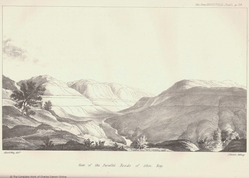
The parallel roads, shelves, or lines, as they have been indifferently called, are most plainly developed in Glen Roy. They extend in lines, absolutely horizontal, along the steep grassy sides of the mountains, which are covered with a mantle, unusually thick, of slightly argillaceous alluvium. They consist of narrow terraces, which, however, are never quite flat like artificial ones, but gently slope towards the valley, with an average breadth of about sixty feet. There are only four shelves which are plainly marked for any considerable length; the lowest one according to MACCULLOCH is 972 feet above the sea; the next above it is 212 feet higher, and the third, eighty-two above the second, or 1266* above the sea; the fourth occurs only in Glen Gluoy; it is twelve feet higher than the third. I shall refer to them either by their absolute altitude, or as being the upper or lower one in the part under description, and not as first, second, or third; for it will be hereafter seen that others occur in every respect similar, only less plainly developed.
It is admitted by every one, that no other cause, except water acting for some period on the steep side of the mountains, could have traced these lines over an exten-
* Some rude measurements which I made with a mountain barometer lead me to suspect that these altitudes are at least a hundred feet too great. It is not a point of any importance with respect to the theory of the origin of the shelves, but I regret that I did not verify their height with more care.
1 This was Darwin's first full-length scientific paper. In it he argued that the parallel horizontal ledges were marine beaches raised above present day sea level by crustal uplift. He later regarded it as a great blunder on his part when it was shown that they were the shorelines of glacial lakes. See Rudwick 1974 and Herbert 2005.
2 Thomas Dick Lauder (1784-1848), Scottish novelist and amateur geologist. Dick 1823.
3 John MacCulloch (1773-1835), physician, chemist and geologist. He was elected to the Geological Society in 1808, and was President in 1816-1817. MacCulloch 1817.
4 The valley of the Roy River, a tributary of the Spean, near Fort William, Scotland. See Rudwick 1974.
sive district. The dark line in the accompanying wood-cut (No. 1.) represents the real profile of a shelf, and is copied from MACCULLOCH. To this I have added two imaginary lines, of which the broken one gives the supposed original form of the
1. 2.
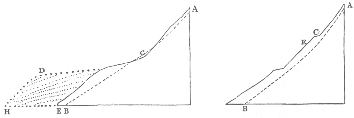
A B supposed original surface of rock; C E line of shelf; C D H line of shelf when expanded into a buttress or terrace.
underlying rock. The formation of the shelf, as may be here seen, is chiefly due to the accumulation of matter in the form of a mound, only very slightly projecting beyond the general slope of the mountain, and partly to the removal or corrosion of the solid rock. The latter effect, although well marked in some particular spots, cannot generally be distinguished, and the shelves no doubt are chiefly due to the accumulation, and not to the removal of matter. In this same diagram (1.) the covering of alluvium is represented as thicker some way below the shelf, than at the same distance above it. I believe this is generally the case, and hence the projection of the shelf is often very obscure; and when two or three occur, one below the other, their outline closely approaches to that represented in wood-cut (2.). MACCULLOCH will scarcely even allow that a shelf in any case forms a projecting mound; but this certainly is incorrect, and is indeed contradicted by his own statements, and by that implied in the comparison of the shelves with the beaches of lakes, which have been suddenly drained. The shelves entirely disappear, where crossing any part of the mountains in which the bare rock is exposed; for loose matter cannot accumulate there, and the rocks themselves from their laminated structure do not readily become worn into any regular form. They likewise disappear where crossing any part which is gently inclined; for their own slope then coincides with that of the alluvial covering, and cannot be distinguished from it.
The dotted line in the wood-cut (No. 1.) is supposed to represent the broader terraces, or even plains, of stratified shingle, sand, and mud, with which the shelves often become united. These terraces do not differ from the shelves in any one essential point of structure, but are much broader; and as the matter of which they are composed is in much larger quantity, a rude kind of stratification may be generally observed. They occur only where the bottom of the valley in its gradual ascent rises nearly to the level of a shelf, or at points on the hill-sides, where it is probable that the streamlets formerly brought down much detritus to the ancient beaches.
Sir LAUDER DICK has observed* that the shelf infallibly intersects the head of such terraces or buttresses: this certainly is the case (as in diagram 1.) with all the smaller ones; and, therefore, we may infer that their formation dates from the period when the shelf was a beach. But at the head of the greater valleys, where the supply of matter must have been more abundant, and where the slope of the land was highly favourable to its accumulation, the line of shelf sweeps across and blends into a plain, which has an uniform slope upwards and downwards above and below that level. Therefore, when the water stood at any one of the shelves, there were many little deltas which did not rise above its level, but some greater ones that were continuous with an upward slope of shingle, filling the bottoms of the main valleys†.
The shelves are chiefly composed of the same kind of alluvium with that covering the whole surface of the mountain; and they seem to have been formed, as suggested by MACCULLOCH, by the check given to the downward descent of ordinary detritus, and that transported by torrents, at the level of the ancient waters; I could perceive no difference in the nature of the alluvium above and below the upper shelf, as stated to be the case by Sir LAUDER‡. It contains fewer well-rounded pebbles at the greater heights than would have been expected on any theory of the origin of the shelves; but they are abundant in the lower and broader parts of the valleys. Nevertheless where there is any level spot at the height of the upper shelves, well-rounded pebbles may generally be found, as on the summit of a rounded hill, or a flat little strait separating some hillock from a line of shelf (for instance near Craigdhu, on the summit of Meal Roy, and between Upper and Lower Glen Roy). In these cases the pebbles must have been almost exclusively formed by the action of the currents and waves of the former expanse of water. They are frequently derived from rocks not found in the immediate vicinity: erratic boulders also are scattered over these mountains. I state these facts distinctly, because MACCULLOCH says§ that the composition of the alluvium of the upper shelves is wholly different from that covering the sides of the broad valleys; whereas the difference is only one of degree, for which many causes might be assigned.
I have already observed, that the quantity of solid rock worn away on the line of any shelf is not usually great. At the narrow entrance, however, of Loch Treig (of which a drawing is given by Sir LAUDER DICK), on the west side, which is very steep, the gneiss is worn into smooth concave hollows, the peculiar curves of which, though
* Transactions of the Edinburgh Royal Society, vol. ix. p. 11.
† These statements are founded on what I saw in Glen Collarig, where the lower shelf (the 972 feet one) blends into a slope, now rendered irregular by the action of the torrents, which rises (at the gap) to a height of more than a hundred feet above the level of the shelf. Again, near the head of Lower Glen Roy, the seam shelf blends into a similar kind of plain, which rises (at the base of a terrace, projecting from the next shelf to it,) ninety feet (barometrically measured) above the level of that shelf to which it may be said to belong. In the east arm of Glen Turet, the upper shelves in a like manner terminate in slopes, which rise above their proper levels.
‡ Geological Transactions, vol. iv. (First Series), p. 320-338, and 387.
§ Edinburgh Royal Transactions, vol. ix. p. 12.
they cannot be described, may be readily imagined by calling to mind the form of rocks washed by a water-fall. This was the only one spot where I could observe this appearance in an unequivocal manner; but this one point of rock would to my mind carry demonstration with it, even if there were not innumerable other proofs, that the water had remained at the level of the 972 feet shelf for a very long period*. On the opposite side of the entrance, or gorge, which here slightly bends before entering Loch Treig, the shelf expands into a line of terrace. Standing on the precipitous and waterworn rocks, it required little imagination to go back to former ages, and to behold the water eddying and splashing against the steep rocks on one side of the channel, whilst on the other it was flowing quietly over a shelving spit of sand and gravel. The only other and rather different case of waterworn rock, which I noticed, was at the head of Lower Glen Roy (pointed out by Sir LAUDER DICK), where the summits of some irregular hummocks of gneiss on a level with the upper shelf were obliquely truncated by a smooth surface. I have frequently observed a similar structure on the rocky shores of protected harbours. Large fragments of rock are scattered on most of the shelves, of which many are of granite, and have come from a distance, as will presently be described; the greater number, however, have merely rolled down from the heights above. Of the latter, some have fallen recently, whilst others are waterworn, as if they had lain for centuries on a sea coast; and it was in many cases easy to point out, whilst walking along the level shelf, which fragments had been washed by the ancient waves, and which had fallen since.
Sir LAUDER DICK has observed, and the fact is very important, that the head of Glen Gluoy is separated from the head of a branch of Glen Roy by a flat land-strait, with which the shelf in the former glen is exactly on a level; so that if Glen Gluoy were filled with water to the full level of its shelf, or a few inches above it, besides a great barrier at the lower end, a little mound, perhaps a foot or two in height, would be required to prevent the water flowing into Glen Roy. In the same manner if Glen Roy were closed at its lower end, and if water stood at the level of the upper shelf, it would trickle into the valley of the Spey. The same thing would happen with the lower shelf at the head of the valley of the Spean; and lastly, a short shelf, which I discovered in a gully, which enters the Caledonian Canal near Kilfinnin†, between
* After the elaborate arguments given by MACCULLOCH, to show that no sudden rush of water, or debacle, could have formed the shelves, I should not have offered any remarks on this point, had not so distinguished a person as Sir GEORGE MACKENZIE (London and Edinburgh Philosophical Magazine, December 1835,)1 suggested such an hypothesis, without, however, it is fair to add, having visited the district. Each of the ten thousand pebbles, which together form any one buttress or little delta, and which, it is evident, were accumulated by the action of one streamlet, at the spot where it entered the expanse of ancient water,—each of these pebbles required time for its attrition,—each now plainly speaks against such an hypothesis.
† I was informed, but whether correctly I do not know, that the hamlet (in the middle of which there is a mound with a round tower on it,) on the opposite side of the valley, and a mile or two south of Invergarry, was named Kilfinnin. I therefore shall denominate the small stream which flows towards the Caledonian Canal at that point by this name. In the same manner I shall call the larger stream which debouches by Habercalder, and its valley, by that name, not having been able to learn any more proper one.
1 George Steuart Mackenzie (1780-1848), mineralogist and phrenologist. Mackenzie 1836.
Loch Oich and Loch Lochy, is in a similar manner on a line with a peat moss, forming the watershed between it and another small valley. These four cases are so remarkable, that the coincidence of level must be intimately connected with the origin of the shelves; although such relation is not absolutely necessary, in as much as the middle shelf of Glen Roy is not on a level with any watershed. Sir LAUDER endeavours to explain this fact by supposing that when the imaginary barriers of his separate lakes were perfect, the water flowed from that end of the glen, which is now highest, in other words, that the drainage of the supposed lakes was in each case in a reverse direction to that of the streams now occupying their beds. This view implies, moreover, the strange accident, that, during the breaking down of the barriers, the part that was originally lowest always remained standing, whilst a higher part gave way; and thus the removal of the barrier must be supposed to have happened from the effects of some causes no ways analogous to the wearing down of the mouths of lakes as they ordinarily exist.
The structure of these land-straits must be now described. This has already been minutely done by Sir LAUDER with respect to that one which connects the sources of Glen Gluoy with those of Glen Turet, one of the arms of Glen Roy. The only additional observation which I have to make, is that the strait is broad and very level, and that on one side I noticed a beach, like that on a sea shore, of well-rounded pebbles. The accounts given by MACCULLOCH and Sir LAUDER of the division of the waters of Glen Roy and the Spey differ in some essential points. The latter author states that the upper shelf of Glen Roy is on a level (excluding the peat-moss) with the flat where the waters divide. This appears to be accurately the case, as far as the mountain barometer (which stood at the same thousandth of an inch on the two stations) and my eye could be trusted. But on the north side of the watershed there are patches of little terraces about fifteen feet above this level, resembling those which in other parts are connected with shelves, and hence probably having a similar origin with them. On the hill-side higher up, other obscure patches of alluvium occur with somewhat analogous forms. The water of the Spey first flows down a gentle mossy slope eastward, and is then collected in Loch Spey. On the south side of this loch, there is an obscure line of terrace, which appears to be about sixty feet above the loch, and which doubtless led MACCULLOCH to suppose the upper shelf of Glen Roy was that number of feet above the division of water. The terrace above Loch Spey, as far as I could judge by the eye without a levelling instrument, is horizontal, and may perhaps be traced along the south side of the watershed, even a short distance within Upper Glen Roy, where certainly there occurs a mound parallel to and above the upper shelf. I much regret I was unavoidably prevented from examining this locality with all the attention it deserved. But from the structure of the small terraces, it appeared to me certain that water must for a period have occupied a level above that of the highest shelf of Glen Roy; and likewise that fragments of a shelf, or line of terrace, which as far as the eye could judge was horizontal, extended within
the basin of the Spey, and therefore beyond the limits of the supposed lake of Roy. This latter fact is, at least, certain, for I have since learned, through the kindness of Sir DAVID BREWSTER,1 that he has seen, as will be hereafter mentioned, shelves resembling those of Glen Roy at two points, at a distance of several miles down the valley of the Spey. The watershed at the head of the valley of Kilfinnin, has precisely the same character with the foregoing cases: here also a flat-topped buttress projects on one side above the level of the shelf, and this seems to indicate, as in the former case, the presence of water at a level rather above that of the shelf itself*.
The division of the waters between most of the glens and ravines in this district, in situations where no shelves occur, does not take place on a sharp ridge, but on level, and often broad land-straits, similar to those just described. I may instance a long one (at an elevation of between 1400 and 1500 feet above the sea,) separating two branches of the water which flows by Habercalder into the Great Glen, and one branch of the Tarf Water. Again another one nearer Fort Augustus, separating the two lowest and nearest branches of the same two rivers; here also there were obscure buttresses on each side above the level of the watershed. An intelligent shepherd who accompanied me, remarked that this form of the land was common wherever the waters in this mountainous country divided; and I observed several instances of it. Finally, I may remark, without wishing to lay any great stress on the argument, that these land-straits, whether connected with the shelves, or not, are precisely what might be expected from straits, properly so called, between arms of the sea being laid dry.
The discovery of any shelf, beyond the limits where they had been hitherto observed, being evidently an important point with regard to the theory of their origin, I shall fully describe the following case. At the head of a small stream which joins the Caledonian Canal, near Kilfinnin, and which is divided from the waters of the Habercalder by a flat mossy watershed already alluded to, some fragments of a shelf occur on the northern side. This shelf resembles in every respect those in Glen Roy; it seemed, as I walked along it, perfectly level, as it likewise did, when I viewed it from either end, and when I crossed the valley. I then took several measurements at the most distant points with the mountain barometer, and the mercury stood within the same hundredth of an inch. On the northern side of the valley, the shelf, which commences on a level with the mossy plain dividing the waters, extends for about a quarter of a mile almost continuously; it is then lost from the number of fragments of rock which have fallen down the hill, but reappears at the distance of more than half a mile from its commencement under the form of two or three little buttresses. These I ascertained by the barometer to be on a perfect level with the commencement of the shelf, or the watershed, a circumstance which was also apparent by the eye alone. The line further on disappears from the rockiness of the sides of the valley.
* The pass of Muckul, described by Sir LAUDER, which separates the waters of the Spean from a branch of the Spey, I did not visit.
1 Sir David Brewster (1781-1868), Scottish physicist who specialized in optics. He invented the kaleidoscope in 1816.
On the south and opposite side of the valley, a broad sloping terrace extends at a corresponding level for about three quarters of a mile, but is indistinct owing to the gentle slope of the mountain. Further on it seems modelled into more than one terrace: and these, though obscure, appear to a person standing on them perfectly horizontal. Although the terraces are not plainly developed on this side, yet it is certain, that horizontal mounds, at nearly the level of the watershed, extend about two miles on the face of the mountain. With respect to the absolute elevation of this shelf, I made it about forty feet above the upper one of Glen Roy, and 1120 above Loch Lochy, or 1202 above the sea: but my barometrical observations have no pretensions to accuracy. After having observed this shelf from so many points of view, I am prepared positively to assert that it is in every respect as characteristic a shelf as any in Glen Roy; and although the fragments of it do not extend over more than, perhaps, half a mile in length, its origin must be as carefully attended to in any general theory of the formation of the shelves, as if its length had been twenty times as great. Its want of continuity and shortness possess, indeed, in themselves much interest, because we thus know that those causes which have marked with horizontal lines the sides of the mountains of Glen Roy in so wonderful a manner, have been in action here, though they have produced but little effect. Moreover, we see that if the surface had been originally rather more rocky, or had been less steeply inclined than at present, or had been subjected to a very little more alluvial action, all evidence would have been obliterated of the extension thus far of the action of these causes.
I have already alluded to the important fact communicated to me by Sir DAVID BREWSTER, namely, that he has seen shelves in the valley of the Spey. At Phones, which is situated about a mile from the Truim, and about five above its confluence with the Spey, one broad and well-marked shelf occurs, along which a carriage can be driven. On the banks of the Spey, about twenty-five miles below its source, two shelves occur in an elevated angle between the Burns of Belleville and the river. They are small; the upper one, however, is very broad; and their elevation is about 800 feet above the sea. Sir DAVID BREWSTER says, that the shelves in both places appear horizontal, and that they resemble those of Glen Roy, though possessing far less grandeur and symmetry. The fact of their occurrence at these distant points is, as we shall hereafter see, highly important.
Section II.—The Theories of Sir LAUDER DICK and Dr. MACCULLOCH considered.
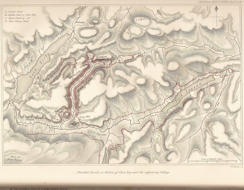
Sir LAUDER believes that a separate lake existed in each valley, where we now see a shelf, and was separately drained. In Glen Roy, where three shelves occur, all plainly developed, (with the exception of Belleville, this is the only place where more than one has been observed,) the arguments in favour of a separate lake possess the greatest force. Without entering into any description of the physical features of Glen Roy, inspection of the accompanying map, taken with some few alterations
from that of Sir LAUDER DICK, will show the course of the shelves; although they cannot of course be followed nearly so continuously in nature as here represented. The lower one (972 feet above the sea) is common to nearly the whole line of the Spean and Glen Roy. The two upper shelves are confined to Glen Roy, with the exception of those short portions extending into Glen Collarig. It will be seen that both these lines, if continued round the hill of Bohuntine (at the eastern entrance of Glen Roy), would insulate it, whilst the lower shelf only forms it into a peninsula. From this structure it will be evident, that in order to form Glen Roy into a lake at either of the two upper levels, it would be necessary to erect two barriers, one across Glen Collarig, and the other principal one across the mouth of the Roy.
The lines are here represented as if abruptly cut off, but this is not so; and the following remark holds good in other cases, namely, that where a shelf terminates without any visible change in the nature of the slope, such as being rocky, &c., its disappearance is so extremely gradual, that it can be traced, sometimes to a further and sometimes to a lesser distance, according to the point from which it is viewed. Of this fact the shelves on the south-east side of Glen Collarig offer an excellent example. In the map, the extremities of the lower of the two upper shelves are represented at the four places where they terminate, as extending beyond those of the upper one. I state this on the authority of Sir LAUDER DICK with respect to those in Glen Roy, and it is conspicuously the case with that pair in Glen Collarig which I have described as disappearing in so insensible a manner. The lower line can there be traced, though faintly, to a point below the houses of the glen opposite a small tributary torrent, and therefore considerably beyond (or nearer the mouth) than the point where the 972 feet shelf crosses the bottom of the valley. Observing in Glen Collarig the gradual disappearance of either set of lines, and that there is not the smallest apparent cause for it in the nature of the ground, the first and obvious supposition is that a sheet of water extended from the Spean into Glen Roy and Collarig, and that the mere widening of the mouths of the latter, as they approached the less protected expanse of the Spean, gradually became unfavourable to the accumulation of detritus, and therefore to the formation of the shelves. This view is greatly strengthened by the extension of the lower line in each case beyond the upper; for of course the supposed unfavourable condition for their formation, that is, the too great breadth and exposure of the sheet of water of which they formed the beach, would affect the line when the water stood at the higher level to a greater distance from the main expanse, or further up the valley, than when it occupied a lower level. It may, however, be argued (and on the hypothesis of Glen Roy having existed as a lake it must be so argued), that as the higher line is the oldest, so its terminal portion may soonest have yielded to those causes which modify the surface of the land. This view, however, receives little support from an examination of the rest of the glen, inasmuch as the two shelves through its whole course are in a state of equal preservation. We must therefore conclude, either that we now behold the shelves
precisely as they were left by the sheet of water, or that if the two upper shelves did originally extend for an equal length on each side of the two glens, that the causes which tend in a small degree (for the existence of the shelves proves that no great changes have taken place) to smooth the surface, have acted over this district with the most perfect uniformity. Moreover, it may be remarked, that wherever a streamlet crosses a shelf, and it is probable from its size that it formerly delivered detritus to the ancient expanse of water, either a greater breadth of shelf or a small buttress there, attests that it was so; and in doing this, likewise attests how perfectly the surface of the land has been preserved. Now I paid particular attention to the following observation, namely, that on both sides of the hill of Bohuntine, and on the opposed mountains, where the shelves terminate, there was not the smallest change in the composition or in the outline of the smooth rounded surfaces. Yet it is in this very spot, where the lines insensibly disappear,—on these very hills, where the little deltas of the ancient streamlets are still preserved,—within this very district, where in the extension of the lower shelf beyond the upper one in the four cases, we have the most satisfactory proof of the action of absolutely uniform causes, either in their formation or in their obliteration; it is here, where the slope of the turf-covered hills is unbroken, where there is not a remnant of any projecting mass, that we are compelled by the theory to believe that the two enormous barriers stood, which formed Glen Roy into the imaginary Loch Roy.
But as it is highly important to show that such a Loch could not have existed, we must for a time, in the face of these great difficulties, suppose the two barriers to have been erected. It may be first remarked, that from the extension of the middle shelf, the barrier in Glen Collarig could not have occupied the only one place, which the structure of the ground indicates, even in the smallest degree, as probable, namely, at the Gap, where the waters divide; but it is necessary to suppose that it crossed the glen at a point some way distant from the Gap, and where the valley has a depth, below the upper shelf, of more than 300 feet. Glen Roy being now converted into a lake, with its drainage reversed, that is, with the water flowing from it by the Spey to the east coast of Scotland, let one of the two barriers, we will say the smaller one in Glen Collarig, give way from the effects of an earthquake or other cause. The lake will now stand at the level of the middle shelf, the barrier having given way eighty-two feet vertically. Again let it burst, and this time rather more than 212 feet vertical must be swept away, so that the larger lake, supposed by Sir LAUDER'S hypothesis to occupy the valley of the Spean at the level of the 972 feet shelf, might send an arm a little way up the glen (as shown by the shelf now existing there) above the point where the barrier stood. Let all this have taken place, but still a barrier nearly a mile long, and 800 feet in height, is left standing across the mouth of the Roy. Must we suppose that each time the barrier in Glen Collarig failed, the one in Glen Roy gave way the same number of feet through some strange coincidence? or are we to conclude that some awful catastrophe at sub-
sequent times, unconnected with the drainage of the lake, which must have passed through the breach already opened, removed the second barrier (either part or all of it) when above water, without having left the smallest remnant of it, or having disturbed the smooth alluvial covering of the steep slopes? The 972-feet shelf is common to the valley of the Spean and Glen Roy, and is supposed to have been formed by a lake, the barrier of which, some miles in length, extended near Highbridge across the mouth of the Spean. This shelf passes uninterruptedly, and with its usual breadth, on both sides of Glen Roy and of Glen Collarig, in the very part where the barriers of Loch Roy, if they existed, must have crossed the valley; therefore the whole, or part of the great base of those enormous barriers, must have been swept away when submerged within the bosom of the imaginary Loch Spean; and this must have been so perfectly effected, that no trace of them is left on the smooth slope of the hill, not even by a greater breadth of the shelf, any more than in the part of the second barrier, which must have been removed when above water*. And all this is supposed to have taken place on the hills, where I have shown how wonderfully the features of the land have been preserved, and where the boulders which were washed by the waves of the ancient water can be distinguished from those which have fallen since. In conclusion, therefore, I do not hesitate to affirm, that more convincing proofs of the non-existence of the imaginary Loch Roy could scarcely have been invented, with full play given to the imagination, than those which are marked in legible characters on the face of these hills†.
The same reasons which render the existence of a separate lake in Glen Roy so excessively improbable, apply with only little less force to each of the imaginary lakes in the other glens. We are, therefore, in giving up Loch Roy, involuntarily driven to the theory advanced by MACCULLOCH, namely, that all the valleys in which shelves occur were included in one large lake; but we shall thus run headlong even into greater difficulties. First, from the structure of the mountains, four immense barriers are required to form the lake‡, namely, one low down across the valley of the
* I have not thought it worth while to enter into all the possible cases of this hypothesis, but have merely taken the most obvious one, which was assumed by Sir LAUDER. If any one has the boldness to come forward from the obscurity of past times, and state his belief that the broad barrier of the Spean was erected as well as removed altogether subsequently to the removal of the two barriers of Glen Roy, then the objection from the uniform breadth of the 972-feet shelf, where crossing the spot which must have been occupied by the barrier of Loch Roy, has less weight, but the other part of the argument remains valid. Again, on the hypothesis in the text, I have not entered into all the possible alternatives of the manner in which the bases of the Loch Roy barriers might have been removed, either when Loch Roy itself, or when Loch Spean was drained, or at some subsequent period by unknown causes connected with the drainage of the imaginary lakes.
† It should be remembered that it is far easier to assert than to disprove. If to explain some phenomenon it was stated that the Thames near London was formerly crossed by a barrier some hundred feet in height, of which it was not pretended a vestige now remained, it is difficult to imagine what kind of evidence would be sufficient to prove the hypothesis false, as long as any one was found willing to admit such an assumption.
‡ I may add, the same number of barriers are requisite, whether we suppose the existence of one, two, three,
Spey, two at distant points across the Great Glen of Scotland, and a fourth across the mouth of Loch Eil, the last being necessary, as MACCULLOCH shows*, from the structure of the Great Glen in that part. It may be safely asserted that more improbable situations could hardly be imagined in the whole of Scotland. It is perhaps useless to ask, were the barriers composed of rock or alluvium? if of the former, they were transverse to every line of hill in this part of the country; if of alluvium, we must assume an unexampled case; for where in the whole world shall we find even one barrier a mile and upward in length, and 1200 feet high, composed of loose waterworn materials? Secondly, the theory of one large lake does not explain in a satisfactory manner the remarkable coincidence between the shelves and the watersheds. Thirdly, when by the bursting of any one of the barriers, the level of the lake had fallen from one shelf to another, the hypothesis requires (as with Loch Roy) that the three other barriers, now high and dry, and distant many leagues from each other, should have been swept away by some unknown power, acting by some unknown and scarcely conceivable means, from the smooth sides of the mountains, without a remnant of them having been left; so that MACCULLOCH even frankly confesses one part is almost as probable (I would say improbable) as another for the position of the barriers. And it should be borne in mind, that these extraordinary forces are supposed to have acted on the outskirts of that large area, throughout which we have proofs, most wonderful and unequivocal, of the entire preservation of the surface of the land, as it was left at a period long anterior to the removal (if such removal ever did take place) of the barriers of the lower lakes. I do not hesitate to assert that this one difficulty, even by itself, would be sufficient to refute the theory of one great lake: Sir LAUDER'S theory has been shown to be equally untenable. It is perhaps here almost superfluous to add, that the discovery of the shelf at Kilfinnin (and probably likewise of those in the valley of the Spey) increases every difficulty manifold; for the valley of Kilfinnin is almost as wide as it is long, which affects one theory, as the lowness of the opposite side of the Great Glen does equally the other. Finally, then, in giving up both, the conclusion is inevitable, that no hypothesis founded on the supposed existence of a sheet of water confined by barriers, that is, a lake, can be admitted as solving the problematical origin of the "parallel roads of Lochaber."
Section III.—Proofs of the retreat of a body of water from the central parts of Scotland, and that this water was that of the sea.
Having now discussed these views which cannot be admitted,—a method of reasoning always most unsatisfactory, but necessary in this instance from the high authority of those who have advanced them,—I will consider some other appearances,
_______________________________________________________________________
or as many lakes as glens; and the argument against MACCULLOCH's hypothesis of one lake, and against that of the separate lakes by Sir LAUDER, are applicable to any hypothesis requiring an intermediate number.
* Geological Transactions, vol. iv. p. 378.
which will perhaps throw light on the origin of the shelves. The valley of the Spean, from the point where it joins the Great Glen of Scotland to where it receives the Roy, is broad, and its bottom moderately level. The solid rock is concealed in almost every part, excepting where the river has cut itself a gorge, by irregularly horizontal strata of gravel, sand, and mud. Large portions of these beds have been removed along the centre of the valley, yet it is quite evident from the fringe or line of terraces which skirt each side, that the bottom must originally have formed a smooth concave surface inclined towards the mouth of the valley. Portions more or less perfect of this same deposit can be followed up the course of the Roy, and up the higher parts of the Spean, where the valley is not too rocky or narrow, to near Loch Laggan. This loch is but little below the 972-feet shelf; and at present I wish, for the sake of the independence of the argument derived from the facts to be stated, to consider only that part of the country which is below the level of that shelf. These irregularly stratified beds, near the mouth of the Spean, attain a thickness of several hundred feet, and they consist of sand and pebbles, many of the latter being perfectly waterworn. Higher up the valley, near the bridge of Roy, the thickness before the central portions were removed appears to have been about sixty feet, but of course the thickness varies according to the original irregularities of the rocky bottom of the valley. Now it may be asked by what agency has this sloping sheet of waterworn materials been deposited along the course of the valley? From the presence of the horizontal shelves we know that there has been no change in the relative level or inclination of the country since this district was last covered with water, and therefore we may argue with safety, that the action of the rivers, as far as it is determined by their inclination, must have been the same since that period as it now is, with the exception of that amount of change which they may have effected in their own beds. Our knowledge that there has been here no axis of elevation, with one part always rising a foot, and another a few inches less; but that the entire system of drainage has remained undisturbed and subject only to its own laws of change, is a circumstance which gives a singular degree of interest to the examination of this district. Now if we look at any portion of these rivers, for instance the Roy above its junction with the Spean, we find it has cut a narrow steep-sided gorge through the solid rock, which is in many parts between twenty and thirty feet deep, whilst on each side there are remnants, as above stated, of a continuous bed of gravel, at least sixty feet in thickness. These beds have certainly been deposited by rapid currents of water, but not by any overwhelming debacle, as may be inferred from the presence of cross layers, and the alternate ones of fine and coarse matter. Seeing also the evident relation of dimension and materials which exists between these deposits and the valleys in which they occur, it can scarcely be doubted that the detritus of which they are composed was transported by the existing rivers. But are we to suppose that the river, as in the case of the Roy, first deposited along its whole course these layers one over another, thus raising its bed sixty feet above the solid rock, and then
suddenly commenced, without the smallest change in the inclination of the country, not only to remove the matter before deposited, but when having gained its former level, to act in a directly opposite manner, and to cut a deep channel in the living rock? Assuredly such a supposition will not be received; and whatever part the river had in the accumulation of these waterworn materials, from the very moment (neglecting the annual oscillations of action from the changing seasons) it ceased to add and began to remove, its power must have undergone some most important modification.
It will perhaps be thought that the mere deepening of the bed of the stream, near the mouth of the valley (the effect being slowly propagated upwards), could have caused the difference between the present and the former action of the river. But it is not difficult to replace in imagination the solid rock in the course of the Spean; and although a few small lakes will be thus formed, the average slope will not differ greatly from the present inclination, and this inclination we see is sufficient to cause the river to wear a deep gorge in the solid rock, and therefore it is evident (although I am aware that without actual measurement of the inclination this argument must rest upon eyesight, which cannot generally be trusted) that a change of this nature would be wholly insufficient to reverse the action of the river, as has here been the case. We must not, of course, at the same time replace in imagination those unconsolidated deposits, the origin of which we are considering; otherwise no doubt the inclination of the bed of the river would be greatly altered; although even in that case I by no means believe that the river would be so much retarded as to deposit matter at the heights where it is now left. Some check, therefore, to the transporting power of the stream seems to have acted at many, or at every successive level. If we reflect on what would result, as an hypothesis, from a river delivering during a long period detritus into a lake, the level of which was gradually sinking from the wearing down of its mouth, a gently sloping surface would be formed at its head. But as the barrier was cut deeper and deeper, and the lake sank, the stream in the part where it was once checked by meeting with the still water would gain velocity, and hence would cut through the beds which it had originally deposited. The fringe, of rudely stratified alluvium, the origin of which we are considering, resembles both in structure and composition such beds of detritus as would have accumulated on the shores of a lake, had one existed in these valleys. If, then, we suppose that a subsiding sheet of water did actually fill this valley, either of one or more lakes, with their barrier gradually wearing down, or of an arm of the sea, the general level of the ocean being stationary during a slow elevation of the land (as now is the case with the fiords of Scandinavia), every appearance on the sides of the valley of the Spean and Roy will be explained; and as there is no other way, that I can see, of accounting for them, the hypothesis is so far worthy of admission.
I ought, perhaps, to have previously observed, that these deposits could not have been formed when the valley was filled with water to the level of the shelves, for the
detritus has the character of matter accumulated in shoal water, and the beds abut abruptly against the bases of the mountains, instead of blending with the alluvium on their surface, as would necessarily have happened had the whole been deposited at the same time at the bottom of one basin.
The conclusion, that these valleys have been occupied by a sheet of subsiding water, follows more plainly from a somewhat different class of facts. I have before remarked, that where a streamlet crosses a shelf, especially if it be the lower one, an obliquely truncated buttress, the form of which was represented by dotted lines in the wood-cut No. 1, projects from the side of the hill. It is quite evident that these were accumulated when the shelf existed as a beach, and the streamlet at present only acts in removing those portions with which it comes in contact. Now in some points where the buttresses have been somewhat largely developed, smaller ones at a lower level, composed of the same irregularly stratified waterworn materials, having nearly the same outline, although unconnected with any shelf, may be observed adhering to the slope of the hill. Instances of this structure occur on the east side of Glen Roy; on the south side of the Spean, and between Loch Treig and the bridge of Roy, the accumulation of perfectly rounded shingle, like that on a sea-beach, was enormous.
3.
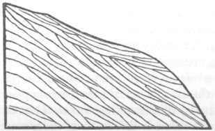
The internal structure in this instance corresponded to the external form, as is shown in the accompanying diagram, where highly inclined beds of sand and coarse gravel are capped by other irregular ones of the same composition, only slightly inclined. In all these cases, where the flat-topped buttresses occur on steep slopes, it is certain (as might have been expected) that the streamlet is steadily at work in removing matter, and does not add one pebble to the mound. No one will dispute, that those buttresses, which are mere extensions of a line of shelf, were formed at the edge of an expanse of water (of which the shelf was the beach), and it is therefore by itself probable that the other buttresses, of similar external form and composition, though occurring at a different level, had a similar origin. But the argument may be put in a stronger point of view: taking the course of one of these streamlets, and observing the size and position relative to it of the buttresses one above the other, it becomes evident that the materials of which they are formed were accumulated through the agency of this stream, although it is at the same time inconceivable that they were left (especially in such a case as that represented in diagram 3.) on the steep slope by a power which, as it now acts, is steadily at work, tearing away matter in its whole downward course. Therefore, it is absolutely necessary to bring into play some intervening or modifying cause in the action of the streamlet; in the case of the buttresses which are connected with the shelves, no one can doubt what this intervening cause has been; shall we, then, rejecting a vera causa, seek some other one, if indeed such other can be found? Cer-
tainly not; and the conclusion is inevitable, namely, that a sheet of water must have stood at as many levels as there are buttresses, and this will include by short steps the whole space between the bottom of the valley and the lower shelf. Judging also from the amount of matter accumulated, we must infer that the water remained at these levels for no inconsiderable periods, although for a lesser time at each than at the level of the 972-feet shelf.
I would even further add, that in any valley (the relative level of the country, one part with another, having remained constant) a single buttress, if composed of such materials as could not have slided down the face of the hill in mass, or could not, judging by the presence of cross layers and alternations of fine and coarse beds, have been deposited by a debacle, indicates that the valley was once partly or entirely filled up to that height by such matter; and if the mass be too thick, or at too great an elevation on the sides of the valley, to allow of the supposition that it was deposited by the streams now flowing in the valley, subject to such changes in its velocity as by the corrosion of its own bed it could effect, then the formation of such buttresses can be accounted for only by the supposed permanence of a sheet of water, whether of a temporary lake or of the arm of the sea, at their levels. Now such projecting masses are extremely common in the sides of most of the tributary streams of the valleys. I conclude, therefore, from the consideration both of the beds of stratified alluvium at the bottom of the main valleys, which there is the greatest difficulty in believing could have been deposited by the rivers under the existing conditions; and of the buttresses on the sides of the hills, which similarly could not have been formed by the present streamlets, that it is satisfactorily proved that the valleys of the Spean and Roy have been occupied by a sheet of water which has slowly and very gradually retired, leaving in almost every part unequivocal evidence of the check which matter drifted by a current meets with, when it arrives at or near to the surface of still water.
I have as yet confined my argument to the valley of the Spean and its tributaries, and to that portion of it which is below the lower shelf; but I may here add, that it may be inferred from the same kind of evidence already used, (I allude more particularly to some buttresses above the 972-feet shelf to the north-east of the houses of Glen Turet, and to a shelf intermediate between the two upper ones, Tombhran,) that water long remained in Glen Roy at an altitude above that which we have as yet been considering, and at other levels besides those indicated by the three shelves themselves. If, also, we look to other valleys in this part of the country, we find similar appearances. For instance, on the flanks of the valley of the Tarf Water, which flows into Loch Ness (at the elevation of about 1000 feet, near the bridge, where the road to Garviemore crosses the river), there are large conical piles, with their summits truncated by a rude terrace, composed of well-rounded pebbles, sand, and an argillaceous earth in irregular beds. Some of the layers of sand and fine gravel were in curves, but slightly inclined; and this structure, together with their
composition, made it at once evident that they must have been drifted into their present position by currents of water. Again, near Fort Augustus, the Great Glen, with the exception of the central part, where the river has worn for itself a broad course, is filled with irregular strata about thirty feet in thickness of sand, gravel, and coarse shingle. In the sand some of the layers are most regularly waved, as if by a tide ripple. These beds are about seventy feet above the sea; fringes of similar deposits skirt at intervals both sides of the Great Glen, but where they are present they do not occur, as far as I was enabled to observe, at a greater height than about 100 feet, that is, than the water-shed of this great valley,—a fact somewhat analogous to the coincidence in level between the true shelves or roads and the heads of the valleys in which they occur. At the south-west end of the Great Glen, nearly opposite to Loch Leven, there are some extensive flats, which from a distance appear to be similarly composed, and which in one part have been modeled into two nearly regular terraces, one rising above the other. A somewhat similar structure may be observed in a part between Loch Eil and Loch Lochy; and this structure can only be explained by water having successively occupied for long periods different levels.
Referring now to more distant points, we find in the broad valley below Loch Tulla (a tributary of Loch Awe, and the stream flowing thence enters Loch Etive,) there are some appearances, although obscure, of the bottom of the valley having been once filled up with stratified alluvium. On the river Tay, however, near Loch Dochart, the phenomenon is clearly developed. On the south side there is a long mound or terrace, about 150 feet high, entirely composed of well-rounded pebbles mingled in layers with a yellow sandy clay. From this point to Tyndrum (at an elevation of between 400 and 500 feet above the sea) there are similar banks of waterworn materials, and in more than one part I observed a fine white sand, like that on the seashore. On each side of the valley where it divides, near Tyndrum, a broad expanse is scattered over with low ridges and flat-topped hills of equal height, from which it would appear that the whole space had once been covered up with these deposits. Towards the mouth of the Tay the terraces and platforms of Strathmore have been remarked by many observers, on the sides of the small neighbouring valley of the Dighty. Mr. BLACKADDER,1 in a letter to Mr. LYELL, says, "A narrow track of gravel, sometimes in the shape of platforms, at others in small hillocks, very similar in appearance to those of Strathmore, extends to the height of about 600 feet; and some isolated patches on the southern face of the Sidlaw Hills occur at a greater elevation." From expressions used by MACCULLOCH and other writers, I am led to believe that beds of similar matter irregularly superimposed over each other, occur on the sides of almost all the valleys of Scotland. In such cases as in that of Loch Dochart, we have no proofs, as horizontal shelves or ancient beaches have not been preserved, that the relative level of the country has remained the same, since the period when it was first traversed by running streams; and therefore it is not absolutely certain that the present rivers, with a very different inclination, might not have deposited the
1 Alexander Blackadder, a civil engineer from Stirling, Scotland.
rudely stratified beds in the lower part of their courses, and afterwards with an altered velocity have cut through them. But as we do know that no such change has affected a large neighbouring region, and as such movements could hardly thus have influenced the drainage of valleys directed towards different quarters, such doubts may be overruled. This being the case, the same argument as before used may be repeated, namely, that the waterworn materials appear to have been transported by the present rivers, and yet that they are so deposited as could not have happened without some intervening cause. The phenomenon demands an explanation; and the only obvious solution is that which from several and nearly independent considerations was proved to have been the case with the Spean, namely, that it had been occupied by an expanse of gradually subsiding water, either of a lake or of an arm of the sea. This conclusion, therefore, may be urged with only little less force regarding many, if not all, of the valleys in this part of Scotland.
It may be asked, of what nature was this sheet of water? If we suppose a barrier erected across the mouth of each valley, and a lake to be thus formed, which sunk from the gradual deepening of its mouth, all the appearances above described would be explained. It is a startling assumption to close up the mouth of even one valley by an enormous imaginary barrier; to do this with all would be monstrous. Of such barriers in the district we are considering I need not say there does not exist any trace, nor need I repeat what I have already said against so vain a supposition as that they could have been swept away by any great debacle from the sides of those hills, of which the whole alluvial covering has been preserved since the period when the upper shelves formed beaches, without even a remnant of them being left; and I may add, that it will hereafter be shown by the clearest proofs, that the ordinary alluvial action, and likewise that of running water, even under the most favourable circumstances of a waterfall, has been far less efficient than could have been anticipated.
But it may be asked, would not the hypothesis of a succession of lakes explain the appearance, the matter accumulated above each delta sloping upwards from one level to another. I can only answer this with respect to those valleys which I have myself seen: in the Spean, Roy, Tarf Water, and some others, it is easy, as before stated, to replace in imagination the solid rock; and although some small lakes* would be
* Sir LAUDER has represented three in his map (Edinburgh Royal Transactions) by the figures 5, 6, and 7. I cannot, however, by any means agree with him in the limits thus assigned to them. Is it meant to be asserted, that there is any barrier perfect, with the exception of such a gorge as the river is now cutting, at the lower end of number (7), on a level with the line at its upper extremity; or so nearly so as to allow of the upper part being considered as a supralittoral delta? Such did not by any means appear to me to be the case. Was not the barrier only supposed to have existed, as in the theory of the shelves? I must also observe that the fringe or deposit does not terminate a little way within the mouth of the Roy, as represented by the line marked (7). It appears to me unfortunate that Sir LAUDER marked the limits of these deposits, which are accumulated in a gentle slope, in a similar manner as he has done the shelves, which are horizontal. Any one would suppose the lines 5, 6, and 7 were horizontal, like those marked 1, 2, 3, and 4, This difference alone indicates a corresponding one in their origin, as will hereafter be attempted to be shown.
thus formed by the replaced barriers (as probably would be the case in every valley), the fringe of stratified alluvium we are now speaking of skirts the valley at an elevation above them. To assume that these rocky barriers were formerly much higher, and were demolished by some means independent of the action of the river (for this action tends only to form a narrow wall-sided gorge, as may be seen in those barriers which certainly did exist), would be as gratuitous as the imaginary erection of one great barrier across the mouth of the valley, and would explain, from the continuity of the slope, the appearances far less perfectly. Moreover, if the origin of the sloping fringes could be explained by the assumed former existence of a chain of lakes, the buttresses high up on the sides of the valleys clearly could not be so. Nor will any one pretend that any lake-theory can be applicable to the deposits on the sides of the great valleys, such as Strathmore, and the Great Glen of Scotland, which terminate in deep and open friths. Therefore it has not been the water of several lakes any more than of one lake, which slowly retiring from these valleys, determined the accumulation of the beds, where we now see them. There is, then, as we have conclusive evidence that an expanse of slowly subsiding water did occupy these spaces, but one alternative, which we are compelled to admit, and this without any consideration of the shelves themselves, excepting so far as they serve as artificial levels to show that the country has not been unequally elevated, namely, that the waters of the sea, in the form of narrow arms or lochs, such as those now deeply penetrating the western coast, once entered and gradually retired from these several valleys.
Section IV.—Proofs from organic remains of a change of level between the land and the sea in Scotland. The effects of elevation traced in hypothesis.
Another question immediately arises; did the waters of the sea slowly subside, or the land slowly rise, the effect in each case being similar? But first it will be proper to show, from the more ordinary kind of evidence, that there has been some change of level between land and water affecting Scotland within recent times, although not to the amount inferred from the arguments above advanced. Mr. Smith1 of Jordanhill, in an excellent paper*, has lately shown from the presence of elevated organic remains, that within a period geologically extremely recent, both the east and west coast of Scotland has been raised some hundred feet; namely, at Banff and near Glasgow† about 350 feet. Considering the facts given in this paper, it can scarcely be doubted, without making the most improbable assumptions, that the Great Glen of Scotland, of which the highest point is only ninety-three feet above the sea, was within this recent period an open strait; and, I may add, it must then have strikingly resembled the Beagle Channel in Tierra del Fuego, an arm of the sea narrower, longer, and straighter, which intersects the extreme southern part of South America. In ac-
* Edinburgh New Philosophical Journal, vol. xxv, p. 376.
† Edinburgh New Philosophical Journal, vol. xxv. p. 386 and 387. The elevated shells at Banff were observed by Mr. PRESTWICH, Proceedings of Geological Society, May, 1837.2
1 James Smith (1782-1867), geologist and biblical historian. Smith 1838.
2 Joseph Prestwich (1812-1896), geologist and businessman. Prestwich 1837.
cordance with this fact, I was informed by the person who now has the charge of the locks on the canal, that when they were cutting through the gravel at the head of Loch Ness many broken sea shells were found in the lower part, which appeared to him like those on the sea-coast. When exposed to the atmosphere they soon decayed. This point must be between forty and fifty feet above the level of the sea. There are remnants, as before stated, in this part of the Great Glen, as well as at the south-west extremity, of coarse sublittoral formations, which, I suppose scarcely any one would dispute, were accumulated before that small change of level took place, which is indicated by the elevated marine remains. That the movement must have been exceedingly slow, may be inferred from the existence of so many beaches, each requiring time for its formation, which rise one above another on both coasts of Scotland. Mr. MALCOLMSON*1 mentions no less than eleven in Elgin, from the lower one of which he procured twelve species of existing marine Testacea. On the opposite coast also, Mr. Smith has described† several ancient beaches between the present one, and the great terrace, between thirty and forty feet high, which "forms a marked feature in the scenery of the west of Scotland." It is also important to observe here, that the supposed greater movement deduced from the nature of the superficial deposits, is of precisely the same slow kind, and interrupted (as will presently be shown) by periods of rest, as this lesser movement, attested by the presence of sea shells and step-formed beaches. If, then, the Great Glen was for a long period occupied by an arm of the sea, which very slowly retired from it, deposits must have accumulated on its shores, and likewise for some little distance within the mouths of the valleys which entered it. If we suppose that the sea stood at the same level in the Great Glen as it lately did both on the east and west coast, then the salt water would have almost entered Glen Roy, and would have wholly covered that sloping fringe of gravel, which has been so often mentioned as skirting the course of the Spean. Whether this be granted or not, after what has been stated it can hardly be disputed, that within recent geological periods an arm of the sea entered at least the mouth of the Spean, and very slowly retreated from it. Remembering that the conclusion was forced on us by distinct lines of arguments, that a body of water must have slowly retired from these valleys, and that lakes sufficiently large to have produced the observed effects could not have existed in them, may we not, with the additional consideration that some parts of the deposits here must be of marine origin, deliberately affirm it proved, that it was the waters of the sea that, even at great heights, checked and banked up at successive levels, the detritus brought down by the ancient rivers and streamlets? I am aware that the argument would have had a greater appearance of strength had I commenced with the inference deduced from the presence of recent shells at con-
* Proceedings of the Geological Society, 1838, p. 669. I was informed by an intelligent quarryman that he had observed many broken sea shells in a gravel-pit, about two miles north of Grant Town, on the roadside to Forres, and therefore eighteen miles from the nearest sea-coast.
† Edinburgh Philosophical Journal, p. 388.
1 John Grant Malcolmson (1803-1844), surgeon and geologist. Malcolmson 1838.
siderable elevations on both coasts of this kingdom, but I preferred the method I have followed, because I believe it is equally legitimate, and of more general application, although at first not so obvious.
From these facts it is certain that there has been a change of level affecting within recent times the whole central part of Scotland, and of a kind very similar to that which has been the subject of so much attention in Sweden, where, according to Mr. Lyell, remains of existing marine animals have been raised to the height of between 500 and 600 feet above the sea. The change of level in the case of Sweden is as certainly known to be due to a slow movement of the land, and not of the water, as it is on the coast of Chile, where a small tract is violently upraised during an earthquake, the distant parts of the same coast being unmoved. It would, however, be quite superfluous here to enter into this question at length, as it has almost ceased to be debateable ground*. It may then be concluded that the supposed great change of level in Scotland, deduced from the foregoing arguments, as well as that smaller fraction of it attested by marine remains and ancient sea-beaches, is due to the rising of the land, and not to the sinking of the waters.
We will now endeavour to trace in hypothesis the effects which would be produced by an arm of the sea slowly retiring from inlets during an equably progressive elevation of the land. In a deserted sound or flat-bottomed valley, surrounded by mountains, curved lines crossing the river would mark the ancient beaches. Each of these lines would be higher than its neighbour on the sea-side, owing to the rising of the land in the interval of their formation, and would be more distant from the head of the valley, chiefly on account of the matter brought down by the river, and in some parts from the natural slope of the fundamental rock. When the upper line formed a beach, it is evident that the whole of the lower part of the valley must have been under water, and that the prolongation of the beach would stretch along the flanks of the adjoining mountains some way inland from the present shore. In like manner each successive and lower beach-line would wind along the steep sides of the hills, and cross the valley further and further from its head. It should be observed, that although I have spoken of successive beach-lines, yet as the land is supposed by the hypothesis to rise at a perfectly equal rate, every part of the valley will have successively formed, during an equal period, a beach; so that each part having been similarly exposed, the slope will be uniform; nor will it be possible to distinguish any one line of beach. Again, if we suppose matter to be removed from the valley by the action of the tides, instead of being added to it by the river, yet as an equal quantity (or a quantity insensibly varying from the varying degree of exposure, as the form of the land slowly changes during its rise) would be removed at each level, the slope in this case also would be uniform. In that part of each successive beach, which winds along the steep flanks of the mountains, it is not probable that much matter would be added, but the downward descent of some portion of the detritus, which is
* An excellent summary of the argument is given by Mr. Lyell in his Elements of Geology, chap. v.1
1 Lyell 1838.
formed on all land by meteoric agency, would be checked; but as it would be equally checked at each successive level, the outline of the mountain would remain unbroken. These same lines, however, although protected in the more inland parts, might suffer degradation where exposed to the greater force of the waves near the mouth of the sound; but the parts differently affected would blend into each other, and so would it be with each successive beach-line; and the slope therefore, whether added to or corroded, or left untouched, would never show the traces of action on any one defined horizontal line. A little reflection will indeed show that when the water stood at the highest level, any part or point which happened to be most exposed would, from the natural slope of all mountains, be some way inland compared with the same relative point on the present coast; at all intermediate levels the waves would attack an intermediate part, either high up and more inland, or lower down and nearer the coast, so that the line (or rather zone) of greatest littoral action, joining the parts which were successively most affected, would, under the conditions of the hypothesis, be inclined with the horizon either more or less, according to the original inclination of the land. Lastly, the river in the valley, as it gained power from the sinking of the sea, would generally remove the central portions, and leave only a fringe of the littoral and sublittoral deposits. This fringe, although formed by successive horizontal beach-lines, would slope upwards, as the whole bottom of the valley would have done if no part had been removed. I allude to this structure more particularly, because it is not at first obvious that matter accumulated on a sea-shore would in any case form a fringe of this kind.
In the hypothesis I have supposed the upward movement of the earth to have been absolutely uniform during equal periods. But this probably has seldom been the course of nature. There is clear evidence that the action of volcanos is intermittent; and the force which keeps volcanos in action being absolutely the same with that which elevates continents (as I endeavoured to prove in a paper read not long since, March 7th, 1838, before the Geological Society),1 so we must suppose that the elevation of continents is likewise intermittent,—a conclusion which receives ample confirmation from the occurrence in nature of successive lines of escarpment, rising one above another, which mark those periods of rest when the sea wore deeply into the former coast. Let us then suppose that the water stood for a longer time at some one level than at any other. The first effect would be, that the beach or delta at the head of the sound, where the river is constantly bringing down detritus, would be broader there, owing to the greater accumulation of matter during this longer period, than in any other part; and therefore when the bottom of the whole valley was converted into land, the slope, which is everywhere gentle, would in that part approach nearer to horizontality; but in other respects there would be scarcely any difference. In like manner, in those portions of the mountains, on each side of the valley, where from the protected nature of the site matter did during the whole rise accumulate, though very slowly, the line would, from the greater quantity of matter added during
1 Darwin 1838.
the longer period of rest, slightly project beyond the general slope of the surface; and where any rivulet came down a very little delta would be formed. Also on any projecting or exposed point, the solid rock would be more deeply cut into than in the other lines. But as the land rose, the little deltas gently sloping from the line of ancient beach, with their front part cut off by the action of the subsiding waters, would project from the hill sides in the form of obliquely truncated buttresses; to the heads of which the horizontal lines of beach will exactly coincide, as indeed they likewise will with the broader ones, where crossing the bottom of the main valleys; but the slope in the latter case will blend both above and below with the inclined surface formed by the matter rapidly accumulated at every successive level. Now it has been shown that Scotland within modern times has undergone a great elevation; it has been shown to be extremely improbable that such movements should be equally progressive: the effects of aqueous action on the surface of the land during the intermittent periods of rest in the elevatory forces have been traced; and it will have been perceived by those who have read the early part of this paper, or the memoirs of Sir LAUDER DICK and Dr. MACCULLOCH, that the results anticipated in the hypothesis are the characteristic features, even in detail, of the "parallel roads of Lochaber": I believe, then, that the hypothetical case gives the true theory of their origin.
Section V.—Objections to the theory from the non-extension of the shelves, and the absence of organic remains at great heights, answered.
Several objections to this view, which implies that the whole country has been slowly elevated, the movements having been interrupted by as many periods of rest as there are shelves, will occur to every one. Perhaps the most important of these is, that, as the upward movement probably affected a considerable area, or at least as it cannot be supposed to have been confined within a defined line, so ought the shelves to be continuous over an equal space. I believe, however, from what I have seen in South America, that it would be more proper to consider the preservation of these ancient beaches as the anomaly, and their obliteration from meteoric agency the ordinary course of nature. Some contingencies seem absolutely necessary for the formation of the shelves, such as a sufficient height in the land, a steep slope, and that the country should be formed of rocks which afforded an abundance of somewhat adhesive detritus; we may conclude, moreover, that the surface must have been covered with turf, immediately after the waters subsided; for otherwise the loose matter would infallibly have been washed from the hills, and this contingency implies a protected, and hence, perhaps, an inland situation, which, at the period, when the water stood at the upper shelves, would leave but a small area. The abundance of detritus no doubt is quite necessary; for although the solid rock is in some parts notched, I do not believe the shelf would anywhere be distinguishable if the soil and detritus were entirely removed from it. It would also appear to be necessary that the valley should either have been originally closed at its upper end,
or that during the period of rest some shallow part in it should have become so from the accumulation of sediment, or from any other cause, so that no stream set through it. Thus the two upper shelves of Glen Roy die away as soon as they enter the valley of the Spean, which must at the period when the waters stood at their levels, have formed an open channel connecting opposite seas. That the ancient beaches in this case extended to that point, beyond which the accumulation of matter was prevented by too much exposure, seems clearly indicated, in a manner before explained, by the extremities of the lower shelf stretching beyond those of the upper. When, however, the 972-feet shelf existed as a beach, the channel of the Spean was converted by the closing of the pass of Muckul into a sound; and the shelf, apparently in consequence, winds along the sides of the valley both of the Spean and Roy. Besides the requisites here mentioned, the shelves appear to be more plainly marked where the valley is narrow, and, perhaps, likewise where it is tortuous. Now from the little I have seen of Scotland, I very much doubt whether these several contingencies occur frequently together; they certainly did not in several valleys which I visited. It must also be borne in mind, that as Sir LAUDER DICK traced the lower shelf very much further than MACCULLOCH had done, and as I found a remnant of one in a distinct valley, and especially as Sir DAVID BREWSTER has seen shelves in two places on the Spey, the probability is that others, though perhaps obscurely developed, will yet be discovered. The irregularly shaped area, in which shelves have already been found, measures in one line twenty British miles, and in another twenty-five.
Notwithstanding what I have now said, the presence of the shelves in some of the glens and their absence in others, in the district of Lochaber itself, is a very extraordinary circumstance. Thus in Glen Roy three lines are perfectly developed, whilst in the neighbouring one of Glen Gluoy it appears that only one exists. It is useless without data to speculate on the nature and force of the tides, currents, and winds of former periods, or on the kind of vegetation with which the land was then covered; all circumstances, perhaps, sufficient to determine the formation or preservation of a mere narrow mound of soft matter on the steep side of a mountain. But the following case proves, and it deserves particular attention, that the limits of the ancient waters cannot even approximately be inferred from the present extension of the ancient beach-lines. MACCULLOCH has drawn in his map a shelf intermediate between the two upper ones, on the face of the mountain (Tombhran) opposite to where Glen Turet joins Glen Roy: Sir LAUDER DICK has not noticed this shelf*. Perceiving its
* Until I saw this shelf I doubted its existence, because I had not been able to discover others mentioned by MACCULLOCH: thus one is figured by him in a ravine branching from Glen Roy (improperly called by him Glen Fintec), which, though having ascended it, I was unable to see. Again MACCULLOCH states, that two shelves occur in Glen Gluoy, whilst Sir LAUDER DICK, who seems to have examined most carefully this glen, could find only one. I may here remark, that should two shelves be hereafter discovered there at the same relative height from each other with those of Glen Roy, and this is stated to be the case by MACCULLOCH, the fact would be highly satisfactory on the theory of the shelves having been sea-beaches. From an excellent point of view, however, on the side of Ben Erin I could see no trace of a second shelf. MACCULLOCH also
importance I examined it with scrupulous care. It occurs rather nearer the lower than upper shelf, and as these two are only eighty-two feet apart, and are here strongly marked, it was scarcely possible (especially as I purposely looked at it from every point of view,) to make any mistake in the absolute parallelism of this intermediate shelf. It can be traced for nearly three quarters of a mile; at the west end disappearing quite insensibly, like the lines in Glen Collarig, but at the other end rather more abruptly in a water course. I walked along its whole length, and its structure is perfectly characteristic; I refer to the materials of which it is composed, its breadth and inclination. The two regular shelves are, perhaps, more plainly marked here than in any other part of the whole glen; and it would appear probable that this is owing to that portion having been exposed to a longer space of open water, by which means the ancient waves acquired a greater than ordinary power in heaping up detritus. In the mouth, however, of Glen Collarig and of Glen Roy, an exposure to a wider channel, but at the same time to one open at both ends, and therefore probably a tide-way, has entirely prevented the accumulation of matter; and hence the beaches gradually disappear there. This view, if correct, as I fully believe it to be, shows by what a slight difference of circumstances, either a remarkable development or an entire obliteration of the ancient beaches has been determined. The intermediate shelf clearly owes its existence to the same causes which have in this part so strongly marked the upper and lower one; and though it is less strongly marked than these two in this immediate neighbourhood, yet it differs but little from them as they ordinarily occur, and is, I think, fully as plain as the lower shelf throughout Glen Spean, I assert, then, that it is an incontestable fact, that water must have remained at the level of this intermediate shelf for a long period, and only a little less long than at the other lines; yet in no other part of Glen Roy, the valley where circumstances have been so pre-eminently favourable for the formation and preservation of these beaches, a trace of this intermediate shelf has been observed. It has likewise been most clearly shown, that barriers could not have existed at the double mouth of Glen Roy, and we have seen that the surface of the land has been preserved in that neighbourhood in a manner quite extraordinary; yet it is known on the authority of Sir LAUDER DICK, who appears to have examined the whole course of the Spean and its tributaries with great care, that not a vestige of either of these upper shelves can be discovered beyond the mouths of Glen Roy. Any argument, therefore, whatever, from the non-existence of the shelves or beaches bearing on the former limits of the ocean over this part of Scotland, during the period of rest in the subterranean movements, is valueless.
_______________________________________________________________________
figures a supernumerary shelf at a point north-west of the houses of Glen Turet, at a level above that of the upper shelf of Glen Roy; a mound of alluvium, above, and nearly parallel to the shelf, certainly occurs there; but from the want of sharpness of outline, I should be unwilling to pronounce that it had formed a line of beach, although I should be far from feeling any surprise if this could be shown to have been the case.
In the valleys of the Spean and the Roy, I attentively examined, with the expectation of finding fragments of sea shells, the matter accumulated on the shelves, and more especially the thicker beds of gravel and sand which occur at lower levels; but I could not discover a particle, and the quarrymen assured me they had never observed any. This may at first be thought a strong objection against the theory of the marine origin of these deposits. But having been led in consequence of Mr. MURCHISON'S1 remarkable discovery of recent sea shells in the inland counties of Shropshire and Staffordshire, to examine many gravel pits there, and having observed how frequently it happens, that not the smallest particle can be discovered in vast accumulations of the rudely stratified matter, and that when found, the fragments are generally exceedingly few in number and partially decayed, I feel convinced that their preservation may be considered as a remarkable and not as an ordinary circumstance. After a longer interval of time, or under some slightly less favourable conditions, all the gravel beds of Shropshire, which no one can doubt were accumulated beneath the sea, would be as destitute of organic remains as those of Lochaber. In some parts of South America I have found beds of gravel which did not contain a fragment of shell, and yet on the bare surface, nearly perfect ones were strewed in numbers. Mr. SMITH describes* beds on the west coast of Scotland, and Mr. LYELL† others in Sweden, undoubtedly of marine origin, but wholly destitute of organic remains. On the coast of Forfarshire also Mr. LYELL, as I am informed by him, found shells in gravel beds extending to the height of between fifty and sixty feet; but at greater altitudes similar beds occur which do not contain any: he has observed the same kind of fact strikingly illustrated in Norway‡. It is easy to imagine several
* Edinburgh New Philosophical Journal, vol. xxv. p. 380.
† Transactions of the Royal Society, 1836, p. 11. and 15.
‡ Mr. LYELL has had the kindness to give me the following observations on this point.
"In the country surrounding the fiord of Christiania, especially between Christiania and Dramman, and between Dramman and Holmstrand in Norway, deposits of clay and sand rest in horizontal beds on the gneiss, granite, porphyry, and other rocks. Large masses of this sand and clay reach in some places to elevations of more than 600 feet above the level of the sea, and nearly fill many upland valleys; but it is only in those patches which occur at the height of about 200 feet, and usually less than fifty feet above the sea, that shells (all of recent species) have been found. This sand and clay appear to have accumulated on the older rocks during their gradual upheaval from beneath the sea, so that greater elevation becomes a test of higher antiquity, and those patches which are found at small heights near the borders of the present fiord are very modern. Even in these last the shells are often in so advanced a state of decomposition as greatly to favour the theory that a more considerable lapse of time might be sufficient to obliterate all traces of their existence. Thus for example, on the banks of a small river about two miles above Töusberg at the place where the bridge crosses it, a section of loamy clay is laid open, the lowest part of which cannot be raised more than a few feet above the salt water of the fiord of Christiania. In the upper part of the mass for a thickness of fifteen feet no fossils can be detected, but somewhat lower faint casts of the Mytilus edulis, chiefly indicated by purple stains, are observable. Still lower down more perfect specimens of the same shell, together with Cardium edule, occur, but both in so soft a state as to crumble into dust when dried. With these the more solid Cyprina islandica and Saxicava rugosa are occasionally found, and although soft when first taken from the matrix are capable when dried of being preserved entire. If in the short period which has probably passed away since these shells
1 Roderick Impey Murchison (1792-1871), army officer and one of the foremost geologists of the era, president of the Geological Society of London, 1831-1833 and 1841-1843, president of the BAAS, 1846, president of the Royal Geographical Society of London, 1843-1858 and Director-general of the Geological Survey of Great Britain, 1855.
circumstances which might determine the preservation or decay of the shells; even on the assumption, which is not necessary, that they have in all such cases been imbedded. Thus in Shropshire, the gravel is covered in most parts by an earthy deposit, which contains a small proportion of lime; hence the rain water having absorbed carbonic acid gas in its descent, would find matter to dissolve before it reached the layers containing shells; whereas in Lochaber the gravel and sand, being derived entirely from granite rocks, does not, as I ascertained, usually contain any free carbonate of lime, and consequently the fragments of shells would more readily be dissolved. I do not wish to assign this circumstance* as the real cause of their disappearance, but merely to indicate it, and other similar ones, as quite sufficient to show that the marine origin of the shelves cannot be controverted from the absence of organic remains.
Section VI.—Application of the theory to some less important points of structure in the district of Lochaber, and recapitulation.
By considering the hypothetical case above given, I think it was shown that the proposed theory explains every essential point in the phenomenon of the parallel roads. And I will now endeavour to show how far it applies to some minor points of detail. For instance, I have described a horizontal band of rock on one side of the narrow mouth of Loch Treig, with its face worn into smooth concave forms, like those over which a water-fall rushes; and on the other side, a great spit or bank of sand and gravel. Now on the belief, that a sheet of water seven or eight miles long, and two or three broad, was drained during each ebb-tide to the depth of several feet through a narrow curved channel, and then again raised by the following tide to its former level, the effects there produced are quite intelligible. It is also easy to perceive, that through the means of the tidal action, points of solid rock might have been obliquely cut off in the same manner as on existing beaches; and that flat channels, resembling in every respect those which at present frequently separate small
_______________________________________________________________________
near Töusberg were imbedded, the progress of decay can have proceeded so far, we may well suppose the percolation of water during antecedent ages of indefinite extent to have destroyed all signs of fossils in the more ancient and elevated patches of loam found more than 500 feet high in the adjacent hilly country."
* I may observe that it very frequently happens, that shells are found only at some depths in these superficial deposits: this is the case in several of the gravel pits in Shropshire; in cutting the canal at the head of Loch Ness, the shells were met with at the bottom, whereas, the layers nearer the surface, as I can vouch, contain none. Mr. SMITH speaking (p. 380 and 391. vol. xxv. Philosophical Journal,) of the clay beds on the west coast of Scotland, says, that the marine remains with which it abounds "are almost invariably found in the lower part of the bed." I infer that in all these cases shells originally existed in the upper part, but have since decayed: Mr. SMITH, however, offers a different explanation. In the extensive and superficial beds of elevated shells on the coast of Peru, where rain does not fall, and where consequently loose matter is not washed from the surface, I have traced as I have ascended from the beach a most perfect gradation in the decay of the shells, until a mere layer of calcareous powder, without a vestige of structure, alone remained.
islands from larger ones, might have been worn between hummocks (such as those on one side of Meal-derry) and the lines of shelf.
If, again, we consider what must take place during the gradual rise of a group of islands, we shall have the currents endeavouring to cut down and deepen some shallow parts in the channels, as they are successively brought near the surface, but tending from the opposition of tides to choke up others with littoral deposits. During a long interval of rest in the upward movements, from the length of time allowed to the above processes, which essentially require time (though they are favoured by the rise of the land rather than by its remaining stationary), the tendency would often prove effective both in forming by accumulation of matter, isthmuses, and in keeping open channels. Hence such isthmuses and channels just kept open, would oftener be formed at the level, which the waters held during the interval of rest, than at any one other. These isthmuses and channels when left by the receding waves, might be called land-straits, for they would present smooth, flat, narrow surfaces, connecting more open spaces. During the rise of the land they would at first separate the heads of two adjoining creeks, and afterwards, the upward movements proceeding, they would form the watersheds between adjoining and opposite glens. By this means, I explain both the ordinary structure of the land in these mountains, where the waters divide, as already described; and more especially the remarkable fact of the exact coincidence of several such points with the lines of shelves,—the shelves only indicating the long interval of rest in the upward subterranean movements. It may be remembered that I described at the head of the Roy and of the glen near Kilfinnin, patches of alluvium or remnants of terraces on the sides of the land-straits, a little above the flat where the waters divide. This structure is in perfect accordance with the theory that drift matter began to accumulate in such parts at that period, when the tides in them were first checked, or otherwise affected by the rising of the land; and that the channels were finally closed at their present levels, solely from the long interval during which the sea acted at such levels. Hence, also, we might have expected, that patches of alluvium would occur (as is the case) on the sides both of the land-straits which are, and those which are not connected with shelves at corresponding levels.
From the levels taken by Mr. MACLEAN1 with Sir LAUDER DICK, it appears that the upper limit of the Glen Gluoy shelf, which coincides with the division of the waters, is twelve feet higher than that of Glen Roy. The intervening space is nearly a mile in length, moderately broad, and very flat, having only a fall of the twelve feet; and Sir LAUDER states* that he saw in this part the surface of the solid rock in the bed of the little stream. These facts seem at first to indicate that two periods of rest had supervened, one when the water stood at the level of the Glen Gluoy shelf, a second when at the upper level of Glen Roy after a rise of twelve feet, and that, nevertheless, the effects of these two periods of rest were confined respectively to separate, though closely adjoining glens. This circumstance if so interpreted, although improbable in
* Edinburgh Transactions, vol. ix. p. 35.
1 Mr. Maclean was a civil engineer who accompanied Lauder Dick.
the highest degree, could not be considered as subversive of the theory, after it has been ascertained that the upper shelves of Glen Roy are not prolonged into the valley of the Spean, and that the short intermediate one in Glen Roy does not extend for more than three quarters of a mile in that valley. There is, however, I suspect a more satisfactory explanation. In the First Narrow of the Strait of Magellan, the tide rises about forty feet, as Captain FITZROY informs me, whilst eighteen miles to the west at Gregory Bay, the rise is only about twenty feet. Here then, and other instances might be adduced, in a distance of eighteen miles, the surface of the water must slope no less than twenty feet. Let us suppose a rocky barrier (and that of Glen Gluoy is rocky) to be elevated, by such movements as those now in progress in South America, across the strait, separating it into two portions. Might we not expect that the high water mark would rise several feet higher, in that portion of the former channel which was still open to the sea subject to the great tidal movement, than it would in the other connected only by tortuous passages with a different sea, where the rise of the tide was small? In such a labyrinth of channels as this part of Scotland must have presented when the sea stood at the level of the upper shelves, it is even probable that there would be inequalities in the rise of the tide in different parts; I conclude therefore that when the rocky barrier was upraised between Glen Gluoy and Glen Roy, a greater tide-wave, proceeding direct from the line of the Caledonian Canal, then a great strait, swept up this deep creek; whereas a smaller one reached by a circuitous course the Bay of Glen Roy, which, moreover, was connected by some other straits with the eastern sea.
Whoever walks over these mountains, and believes that each part has been successively occupied by the subsiding waters of the sea, will understand many trifling appearances, which otherwise, I believe, are unintelligible. Thus in Upper Glen Roy he will see in the level expanse, an old bay, filled up and leveled with tidal mud. Again at the Gap of Glen Collarig, with its flat bottom and cut off sides like a gateway, he will recognise a channel, at last choked up with matter drifted by the tides, and now left in the state in which it was when the waters retired from it. The traces of supernumerary shelves will offer no perplexity to him, and will equally receive with the others a simple explanation. By the theory of the sea having acted at successive levels over the whole surface of the land, the great beds of shingle* and sand,
* I have before alluded to the fewness of the well-rounded pebbles near the upper shelves, excepting at the heads of the valleys, or on flat places. This is a difficulty; though it is one common to many regions, where we know that much denudation has taken place at some period or at another. Pebbles of most rocks may in the course of time decay, but those of quartz I should think (although SCORESBY1 says this rock yields to the frosts of Spitzbergen) would be imperishable: if so, how comes it that quartz pebbles are not scattered over the surface of every mountain in which that rock is present, and in which the form of the land, its denuded state, or the presence of truncated dikes show that it must once, although perhaps countless ages since, have been beaten by the waves of the sea? Such pebbles, however, are not found on every mountain thus circumstanced: the explanation, I presume, rests in this; that every cause of disturbance, wind, rain, earthquakes and the fall of fragments all tend to move the pebbles in one direction alone, namely downwards. I am inclined to believe this view is
1 William Scoresby (1789-1857), clergyman and scientific voyager. Scoresby 1820.
such as those near the mouth of the Spean, have a cause assigned to them adequate to the effect. Lastly, the manner in which the deposits near the mouths of the larger valleys have been modeled into successive terraces, which in some parts at least appear not to have been formed by the river, receives elucidation. I may add, that in South America I have observed numerous instances of terraces in every respect similar to these, with sea shells abundantly scattered on their surface; and therefore where there could exist no obscurity regarding their origin.
In concluding this part of my paper I will recapitulate the course of the argument pursued. 1st. It is admitted by every one that the horizontal shelves are ancient beaches. 2nd. I showed that no lake theory could be admitted on account of the overwhelming difficulties in imagining the construction and removal at successive periods of several barriers of immense size, whether placed at the mouths of the separate glens, or at more distant points. 3rd. The alternative that the beaches, if not formed by lakes, must of necessity have been so by channels of the sea, was not advanced, only because it was thought more satisfactory to prove from independent phenomena, that a sheet of water gradually subsiding from the height of the upper shelves to the present level of the sea, occupied for long periods not only the glens of Lochaber, but the greater number, if not all the valleys of this part of Scotland; and that this water must have been the water of the sea. 4th. It was stated (the strongest argument being the ascertained fact of the land rising at the same time in one part and sinking in another,) that in all cases the land is the chief fluctuating element; and, therefore, that the above change of level in Scotland, independently attested by marine remains at considerable heights on both the eastern and western coasts, implies the elevation of the land, and not the subsidence of the surrounding waters. 5th. It was shown that in all such prolonged upward movements it might be predicted, that there would be intervals of rest in the action of the subterranean impulses. 6th. By an hypothetical case, the land was subjected to the above conditions, and its surface was found to be modeled in a manner wholly similar, even in detail, to the structure of the valleys of Lochaber as they now exist. 7th. The true theory being considered thus established, objections to it from the non-extension of the shelves, and from the absence of organic remains at great altitudes, were answered and shown not to be valid. 8th. Many points of detail in the structure of the glens of Lochaber, were shown to be easily explicable on the supposition, that the valleys had been occupied by arms of a sea subject to tides, and which had gradually subsided during the rising of the land. Having attentively considered these several and
_______________________________________________________________________
correct, and that in the course of time, such pebbles are all rolled down, from having found on an isolated mountain of quartz in South America (the Sierra Ventana) a superficial patch of conglomerate, like part of an old beach, which seemed solely to owe its preservation to the pebbles having been cemented to the parent rock by oxide of iron, in the same manner as not unfrequently may be observed on some existing sea beaches. In the case of the shelves of Lochaber, it is probable, that only a few pebbles were originally formed, owing to the small power of the waves on the steep and protected shores of these ancient sounds.
independent steps of the argument, the theory of the marine origin of the "parallel roads of Lochaber" appears to me demonstrated.
I may here remark, that MACCULLOCH seems to have been aware of the great difficulties attending his theory: but having proved that the roads could not be works of art, or the effects of any great debacle, he argued, to use his expression from the dilemma of the case, that they must have been formed on the shores of a lake. The idea of a continent slowly emerging from beneath the sea, appears, and it is a very curious point in the history of geology, never to have occurred to him as a possibility, although he was so bold and ingenious a speculator. His paper was read in the beginning of 1817, and when we reflect that during the few latter years, proofs of such movements have accumulated from all quarters of the world, we must recognise how much of this all important change (the foundation-stone, I may add, of this paper) is due to the Principles of Geology by Mr. LYELL.1
Section VII.—On the erratic boulders of Lochaber.
I will now pass on to some other considerations which partly derive their interest as dependent on the truth of the foregoing theory. I have said, that the parent rock of many of the fragments lying on the shelves is not found in the immediate neighbourhood. These erratic boulders are generally of granite, and are from one to five and six feet in diameter; they are not confined to the shelves, but are scattered on the sides of the mountains. On the summit of the insulated hill of Meal-derry, above the level of the 972-feet shelf, there was one of large size, together with some well-rounded pebbles of rocks, which, I believe, do not occur there. In the gap of Glen Collarig the boulders on and near the upper shelves are frequent, as they likewise are in the pass between Upper and Lower Glen Roy; they occur also abundantly at the bottom of the latter valley, and on the side of Tombhran. From having found them in almost every part which I examined, I have little doubt that they are distributed in numbers over all the valleys and mountains, at least, to an elevation as great as that of the upper shelves: I make this latter restriction, because having ascended the mountains only in a few places above that level, I cannot speak positively with respect to the greater heights. On the mountains, however, between Glen Roy and Glen Gluoy on a hillock north-north-west (magnetic) of the summit of Ben Erin, I found several masses of granite, one of which was four feet by three in width and two in thickness (together with a couple of pebbles from rocks not in situ) resting on the surface of the gneiss. This hillock seemed to be entirely composed of the latter rock, and it was separated from all other hills by a valley. On the flanks of Ben Erin at about the same level, there were several boulders of granite, one of which was six feet across. Of those on the hillock (probably there were many others which I did not see in merely crossing the mountain,) the highest one was found by comparison with the Glen Gluoy shelf (by means of the barometer), to be 2200 feet above the level of the sea. I will describe in detail the spot where I found one other boulder,
1 Lyell 1830-3.
in as much as the whole of the district being composed of gneiss, it might be suspected that patches of granite occurred high up on the slopes of the mountains, and that the fragments had simply rolled down into their present positions. This, however, could not have happened in the case last described, nor in the following one: about twenty feet below the summit of a very sharp peak (1600 to 1700 above the sea) the whole of which consisted of tortuous layers of gneiss, there was a block of syenite with pink felspar, two feet eight inches across. The peak is wholly separated (as shown in the wood-cut, fig. 4.) from a lofty mountain also of gneiss, by a broad and quite flat valley, the highest part of which is 215 below the spot where the boulder lay. I may observe that I did not anywhere see another boulder of the syenite, nor a single one of granite on this side of the mountains, which is separated by a lofty ridge from the valleys of Glen Roy and Glen Gluoy, where the blocks of granite are so numerous. Between two branches, however, of the Tarf Water (which enters Loch Ness near Fort Augustus) on the summit of a hillock of gneiss, about 1200 feet above the sea, I noticed one of granite.
Fig. 4.
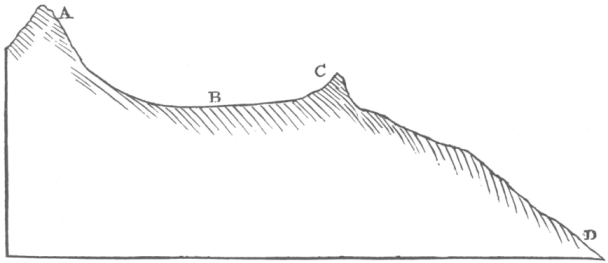
A. Lofty mountain of gneiss.
B. A peat moss 215 feet below the boulder, dividing the waters flowing on each side round the hill C.
C. Boulder of syenite resting on gneiss 1600 or 1700 above the sea.
D. Habercalder in the great glen of Scotland.
The granite of all the boulders which I observed in Glen Roy, and likewise of those on Ben Erin, has a uniform character; it is subject to much disintegration, and therefore I do not doubt that the boulders were originally much larger. In MACCULLOCH'S Geological Map of Scotland, the nearest granite in situ to the boulders on Ben Erin is seen to be at the source of the Roy, near Loch Spey, a distance in a north-east line, passing over mountain and valley, of between five and six miles. The granite there has the same lithological character with that of the boulders, and I do not doubt that it is the parent rock, at least, of those strewed along the course of the Roy. With respect to the boulders on Ben Erin, they are completely cut off from every granitic district by valleys, the highest point of which is 920 feet below that boulder, the altitude of which I measured; that is, it would be impossible to walk from granite in situ to these boulders without ascending at least that number of feet.
I will only further add, that if a sheet of water were raised to the level of the Ben Erin boulders, there would be a line of open communication* between them and the granite of Loch Spey; although I must confess I much doubt whether in that case any of the rock in situ at Loch Spey would remain uncovered; and if so the origin of the boulders must be more remote. The other tracts, where granite is represented in MACCULLOCH'S map, are more distant, and are separated by deeper and broader valleys from the points in question. From my limited examination of the district of Lochaber I am unwilling to generalize respecting the position of the boulders, but I think that they certainly occur most frequently on the summits of little peaks, such as on Meal-derry, or on that one of which a wood-cut has been given; and perhaps likewise in the narrowest parts of the valleys; for instance at the junction between Upper and Lower Glen Roy. I observed also a greater number on the shelves than I should have anticipated, from some of those, which had originally stood higher, having rolled down. But, I repeat, I will not positively say that such is the case; although with respect to the boulders on the peaks, as I observed five well-marked cases, even during my short examination of the country, I have little or no doubt that the observation is correct.
On any conceivable theory of the transportation of erratic blocks, whether by some overwhelming debacle, or by floating ice, or any other means, it will at once be evident that they must have been scattered over the country, either before the shelves were formed, or at the time of their formation, but not on account of the delicacy of the lines at any after period. According to the generally received opinion of geologists, the so-called "erratic block period" is recent, and therefore we obtain a rude method of estimating the age of the shelves, and consequently of the elevation of the whole central part of Scotland, at least to a height of 1278 feet (or that of the upper shelf) above the sea.
It may perhaps be worth while briefly to compare together, under the conditions here afforded, the two theories of the transportation of erratic boulders, which are alone worthy of consideration, namely, that of great debacles and of floating ice. I will not lay any stress on the difficulty of imagining, in accordance with the first theory, a rush of water so impetuous as to transport vast masses of rock across profound valleys and up the steep sides of high mountains, for this difficulty has no special reference to the case of Lochaber; but those who believe in the past occurrence of so terrific an agitation of the waters of a deep sea, must in some manner account for the frequency of boulders in the most exposed places on the summits of hillocks, and likewise for so many having been left in narrow straits, where one would have anticipated the most impetuous rush of water. On the face of Tombhran I observed many boulders scattered on the shelves, which have been formed there not
* This is a similar fact to what has been observed on the Jura. Sir JAMES HALL1 (Edinburgh Royal Transactions, vol. vii. p. 143.) says "it is principally where the snowy summits are visible from the face of the Jura by means of some depression in the intervening hills, that we find these travelled masses."
1 Sir James Hall (1761–1832), geologist and chemist and advocate of the geological theories of James Hutton.
only by the accumulation of loose matter, but also by the deep excision of the solid underlying rock. Again, there were other boulders on the shelves on the rocky peninsula near the junction of Upper and Lower Glen Roy, where much of the gneiss has been worn away. Here it was not possible, from the non-existence of higher land, that the boulders could have rolled into their present places from above, after the formation of the shelves; nor was this at all probable in several parts of Tombhran. On the supposition of the boulders having been originally scattered over the country, and the shelves formed at a subsequent period, we have the difficulty, though perhaps not an insuperable one, as we do not know their original size, of believing that blocks of granite have been preserved for a long period on those very places, where a zone of gneiss had been cut into and worn away. Some of the boulders on Tombhran were lying on the surface of the lower edge of the shelves, in parts where, as above said, I fully believe the inclination of the ground was so trifling that it was impossible they could have rolled down from above; but I regret much that I omitted, from not having perceived its importance, to ascertain this point with certainty. If the fact be so, and I scarcely doubt it, it would prove that some action, so quiet as not to have disturbed the small quantity of earth and little stones, of which the shelves are formed, transported these boulders across deep arms of the sea, and left them on the surface of the ancient beaches. The theory, that all erratic blocks, circumstanced like these of Lochaber, have been transported by floating ice, wholly removes these difficulties; for the icebergs, in the first place, would generally land the fragments, with which they were charged, on the lower part of the beaches or shelves; and secondly, those which had arrived not long before a fresh elevation would have been exposed only to a small amount of tidal degradation. Thirdly, the icebergs would frequently be stranded on shoals and islets, over and round which the tides swept; and likewise they would be frequently driven on shore in the narrow parts of the channels, where the waters were pent up. So that in after times, when the land was drained, it is easy to perceive that the boulders would lie scattered in such places, as they now actually occupy in the district of Lochaber. Lastly, this theory requires that every district where boulders are found should have been covered by the sea; here we have independent proofs that such was the case, at least to an elevation of 1278 feet.
In my Journal during the voyage of the Beagle, I have endeavoured to show that the erratic blocks of central Europe were probably transported at that period*, when
* I refer, of course, only to the more temperate and central parts of Europe, but it appears that boulders are sometimes transported in these regions, even at the present time. Sir JAMES HALL, in his Memoir on the "Revolutions which have affected the surface of the earth" (Edinburgh Transactions of the Royal Society, vol. vii. p. 157.),1 states that in the Solway Firth (and therefore in salt water) "a large block of stone, four or five feet in diameter, lying within high-water mark, and well known as having served as the boundary of two estates, was during a stormy night in winter transported ninety yards, and the persons on the spot were convinced that this migration was performed by means of a large cake of ice; formed round the stone, and attached to it, and that the whole had been lifted and carried forward by the rising tide. The course of this stone was
1 Hall 1815.
its climate was more equable (chiefly consequent on the larger area of water), which favours a low limit of the snow line, and therefore the probability of glaciers, the parents of icebergs, descending in favourable places into the sea. It is therefore to this period, if this view be correct, that we must refer the "parallel roads of Lochaber," and consequently the elevation of the land, not only of the 1278-feet portion (which it is certain has been elevated at an epoch not distant), but likewise of the whole altitude, whatever it may be, at which boulders occur. If there be others, as is most probable, at a greater height than that one on Ben Erin, which I observed in merely crossing the mountains at a point 2200 feet above the sea, then by so much the greater has the elevation of the land been within this same period. Mr. BLACKADDER (in a letter to Mr. LYELL) states he has seen on the west coast of Scotland, in the island of Mull, large fragments of quartz rock at the height of 2000 feet, of the same description as that found on some of the adjoining islands and mainland. In Sweden M. SEFSTRÖM1 says that boulders occur at an elevation of 1500 feet; in Massachussets, in North America, they are found, according to Professor HITCHCOCK,2 at 3000; and on the Jura it is well known they occur, from low down, to an altitude of 4000 feet. It is interesting to discover, that in our own country the upward movements, within the same period, have been more than half as great as those which have affected the latter colossal chain. But regarding the exact period, allowance must be made, since on the one hand the glaciers of the Alps, situated ten degrees nearer the equator than those on the mountains of Lochaber, must have much earlier retreated upwards, and failed in descending to the level of the sea, during the change from the former to the present climate; whilst, on the other hand, to counteract the equatorial influence, they were appendages on a greater mass of snow accumulated on far loftier chains.
Section VIII.—On the small amount of alluvial action since the formation of the shelves.
I now pass on to another consideration. MACCULLOCH was much struck with the fact, that in many cases where a shelf crossed a rivulet, I mean one of those silver-like threads of water which descend the flanks of steep mountains in nearly straight
_______________________________________________________________________
marked upon the sand below by a deep and broad furrow, which remained visible for a long time afterwards, as I have been informed by several members of the Society, who saw it after an interval of more than a year." I presume from the position of the stone as a land-mark, and from the distance it was transported by the rising tide, that the furrow left by its passage must have been either oblique or parallel to the shore. What would have been the effect if this large and heavy block had been pushed over a surface of solid rock instead of sand? This question will recall to the mind of those who have read the late papers of Messrs. CHARPENTIER, VENETZ, and AGASSIZ,3 the case of the longitudinally and obliquely scratched rocks of the Alps. In the Addenda to my Journal during the voyage of the Beagle, I have endeavoured to show that the passage of ice, with imbedded fragments of rock, acting at successive levels on the surface of shoals during the gradual rising of the land, offers the most probable explanation of the scratches and grooves, which have justly excited so much attention in Scotland and other places.
1 Nils Gabriel Sefström (1787-1845), Swedish chemist and mining geologist.
2 Edward Hitchcock (1793-1864), American geologist and clergyman.
3 Jean de Charpentier (1786-1855), German-Swiss geologist who studied Swiss glaciers.
Ignaz Venetz (1788-1859), Swiss engineer, naturalist, and glaciologist. He was one of the first to propose glaciers as a major force in shaping the earth.
Jean Louis Rodolphe Agassiz (1807-1873), Swiss-born American zoologist, glaciologist, and geologist. He would later become a bitter opponent of Darwin's evolutionary views.
lines, it frequently entered a little way on each side of the gully. From this fact it is evident that the gully must have been partly formed before or at the time when the shelves were sea-beaches. I particularly observed several instances of this structure. One which struck me most was in Glen Roy, opposite a gap in the mountain which leads to Glen Fintec; here two small threads of water were united at the point where the line of shelf crossed them, and at their junction the rock was much exposed, so that any one would have supposed that the furrow in which they flowed had been entirely hollowed out by their action. But the shelf curved in a little way on each side; and, what was more curious, the apex of turf above the point of junction of the two streamlets had evidently originally formed part of the shelf. By this it was shown that the entire hollow, with the exception of the actual beds of the streams, must have existed as an indentation or little cove on the line of ancient sea-beach. It appeared to me that the extent to which the shelves entered these furrows did not bear any close relation to the power of the streamlets now flowing in them: thus on Tombhran (in front of the houses of Roy) a great gorge which is impassable, and where the rock is bare and shattered, has been deeply cut into by the winter torrents, and yet the shelves enter only a very little way on each side; whereas in other cases we find a hollow or creek of some size, but with an insignificant stream flowing in it, for instance, that opposite the gap of Glen Fintec, which has not even removed the remnants of the shelf from the head of the gully, in which it has flowed ever since the retreat of the sea.
Without entering here into a full consideration how these gullies were originally formed, and whether the indentations made in the beach at one level might not be produced downwards to another, I will only remark, that the sea in most situations certainly does alter the form of its coast, and yet that an accurate map of any shore gives a line indented in such manner, that a series of them, if placed one above and a little behind another, would produce the same kind of furrowed surface which characterizes the mountains of Lochaber, as well as most others. I will further observe, that when travelling along the shores of northern Chile and Peru, where the alluvial action is reduced to an exceedingly small measure, and where it is not probable that within a recent period there has been any great change of climate, I was repeatedly much surprised at observing how absolutely similar all the minor inequalities of the surface (yet covered with beds of sea shells of existing species) were to those of countries, where almost every detail in outline is usually attributed to meteoric agency; I could perceive only one difference, namely, that the larger valleys had unusually flat bottoms. Although fully convinced of the truth of this fact, I confess I was astonished at discovering in the mountains of Scotland, which have been exposed during a vast period to the destroying action of a wet and boisterous climate, clear proofs that almost every furrow and inequality has been left nearly in the state in which we now see it*, by the retiring waves of the sea. From the preservation of
* It is scarcely possible to convey by language any accurate idea of the kind of inequalities which, from the
some of these beaches, one can point to the very spot, and declare so much was removed when the sea stood there, and so much since by the running streams of fresh water.
It may be asked, has the present alluvial action done nothing here? Something it assuredly has done, but I repeat, comparatively nothing to that which was effected before the sea retreated. In Chile I concluded that the action of the more rapid rivers and torrents was chiefly confined to removing the littoral and sublittoral deposits left by the arms of the sea; and secondarily in cutting, as soon as the upper beds were removed, a wall-sided gorge through the solid rock. It appeared, that as long as the river had its passage through the water-worn materials, from the great facility with which it changed its course, its bed was broad, but as soon as it reached the solid strata it became exceedingly narrow. These conclusions are in strict conformity with what I observed in the glens of Lochaber. Of the small amount of corrosion effected since the sea stood at a level of the upper shelves, there are some curious instances. Sir LAUDER DICK, in describing in detail the head of Glen Gluoy*, concludes that the river has worn there, during the immense period which must have elapsed since the water (of the sea) retired from the 1278-feet shelf, a remarkable chasm, between fifty and sixty feet in depth, but only a few feet wide. The stream in the northern arm of Glen Turet has cut for itself a passage in the solid rock in only a part of the valley, between the middle and the 972-feet shelf. In Upper Glen Roy the southern stream falls into the plain by a cascade, to the upper edge of which on each side the 1226 shelf approaches close. I did not ascend the spot, but as far as I could judge, the water has not cut back more than at most a few yards, into the rock over which it falls. Other similar instances might be adduced. Although none of these streams form great bodies of water, yet when flooded by the winter rains they cannot be inconsiderable; and their action has been prolonged for so vast a period, that the geographical features, together probably with the climate of the country,
_______________________________________________________________________
shelves passing over them and into the intervening hollows, we know were so left by the sea. I hope any one who feels interested on this subject, will carefully examine the plates accompanying Sir LAUDER DICK'S paper (Edinburgh Transactions, vol. ix.), and especially Plate IV. The shelves on the left side (looking up the glen) bend into all the principal gullies; and on the right side, directly in front of the foreground, by looking close at the plate they will be seen to curve a little way into each of the perpendicular furrows (some thinning out and others commencing), the bottoms of which have evidently been much deepened by the descending streamlets. The idea given by these plates of the state of surface in these mountains, and of the manner in which the shelves bend round the headlands and enter the gullies, appears to me exceedingly faithful; although the glen itself, as represented, is too narrow and profound, and the sides much too steep. To view this Plate is a lesson full of instruction to the geologist, for he will scarcely fail to be astonished when he sees that the drawing is characteristic of any ordinary valley in a mountainous country, and at the same time to find himself compelled to admit, that even the little furrows, which it might be thought had been formed but yesterday, must have owed their origin, at least in great part, to the successive coves or indentations, continued one below another on ancient sea-beaches.
* Edinburgh Transactions, vol. ix. p. 26.
have been greatly changed. The rocky crests of the mountains no doubt have suffered from the weather; but the perfection of the shelves over spaces many hundred yards in length, and in the case of Glen Roy (where the three shelves occur) of some hundred feet in vertical height, clearly proves that as the sea left the greater part of the surface, so does it now remain. Amongst mountains the bursting of temporary lakes may sweep away or accumulate vast quantities of rubbish in the valleys; earthquakes may hurl down piles of fragments; and torrents during the lapse of ages, or under favourable conditions (such as the descent of many pebbles), may excavate a gorge of almost any depth, but which, as far as it is possible to judge, will always be narrow and steep-sided. All this must often have happened, and will so again; but the glens of Lochaber plainly show that the effects of ordinary alluvial action is exceedingly small, far smaller than any one would have anticipated. And as their outline does not differ in any marked degree from that of all other valleys, this conclusion may be extended to other cases.
In Glen Roy, where the three shelves can be seen near each other, little or no difference can be perceived in their state of preservation; indeed the upper one, I think, is more perfect than the one below it. From this fact an argument has been advanced by Dr. MACCULLOCH, that no long interval of time could have elapsed between their formation. But this view is quite inadmissible; either the worn and deeply notched rock of the shelves on Tombhran, or the buttresses on the middle shelf (as at the head of Lower Glen Roy), which are composed of large masses of well-rounded shingle, is sufficient, without considering the intermediate shelf and other appearances, to prove that the water must have remained at levels intermediate between the highest and the 972-feet shelf for very long periods. Hence the alternative is obvious, and is in direct accordance with what has already been advanced, namely, that the ordinary alluvial action is so exceedingly small, that whether the surface has been exposed during one, two or more whole epochs, no sensible difference can be perceived in the state of its conservation.
Of the many remarkable features in the geology of this district, few, perhaps, are more remarkable than this perfect preservation of its surface. We have a mound composed of soft materials so small, that it oftentimes cannot be distinguished, by a person standing on it, from the adjoining slope, but which it is not probable, from the structure of the mountains, was ever much larger; and yet this very mound, when viewed from a distance, will be seen to extend for many hundred yards, even miles, continuous and perfect, with the exception, perhaps, of a few small breaks, where some streamlet descends. On these same mounds we can sometimes distinguish those fragments which have been washed by the little waves of the ancient waters, from others which have since fallen; and at Loch Treig, at the height of 972 feet above the sea, the tide-scooped rocks appear as if scarcely a century had elapsed since they were washed by the ripple of the eddying currents. The preservation of the druidical mounds in Britain has often been adduced as a circumstance worthy of attention;
but here during a period which cannot be reckoned by thousands of years, but only by those great revolutions of nature which are the effects of slow and scarcely sensible changes, works smaller than those ancient ones dedicated to superstition, retain each outline nearly as perfect as when first formed by the hand of nature.
These facts are interesting under another point of view, for they prove to us that we may trust the plain inference of our experiences. Although we see* the stone of many ancient buildings decaying and crumbling away, yet we know that others, as the obelisks of Egypt, have lasted more than three thousand years, with the hieroglyphics nearly perfect on them: now we cannot see any reason why their general outline, even in points of detail, should not last a hundred times three thousand years. Again, although we might expect the crest of a mountain range to be shattered, and the bed of a torrent to be worn down more or less deeply, yet if we look at a convex slope of soil clothed with turf, and drained on each side by rivulets, we can see no reason, as long as the vegetation is persistent, why such a slope (with the exception of any spot where a waterspout might burst, or a stroke of lightning fall) should not last for as many thousand centuries as the obelisks of Egypt shall remain entire. Of the justice of these inferences, conclusive evidence is afforded by the state in which we now see the mountains of Lochaber,—a state of which we approximately know the high antiquity.
Section IX.—On the horizontality of the shelves, and on the equable action of the elevatory forces.
Sir LAUDER DICK, with Mr. MACLEAN'S assistance, seems to have determined within very small limits the absolute horizontality of the several shelves. A delicate eighteen-inch levelling instrument, made by JONES,1 was employed. Sir LAUDER says†, "Directing the object-glass of the instrument to the nearer, and immediately opposite corresponding line of shelf, it applied all along most accurately to the horizontal hair; but when pointed to those further off (some of which were perhaps five or six miles distant), they appeared to sink sensibly below the hair, and this in proportion to their distance from the point where we stood; but they were nowhere observed to do so in a greater ratio than the allowance for the curvature of the earth at such rectilineal distances demanded. And, what was in our opinion most conclusive, when the telescope was pointed to, and made to traverse along any particular portion, which, from being directly opposite to the eye, might have been presumed to be nearly equidistant in all its parts, it was found to preserve an uniform relation to the horizontal hair." The same results were obtained in other instances; but yet the angle of depression of the distant shelves does not appear to have been actually measured, and its correspondence with the curve of the earth calculated. But it is quite certain that if any
* Consult Professor PHILLIPS'S interesting paper on this subject. Geological Proceedings, vol. i. p. 323. April, 1831.2
† Edinburgh Transactions, vol. ix. p. 8.
1 W. and S. Jones, scientific instrument makers, London.
difference from that curve exists, it must be very small*. Here then is a case which supports apparently with more weight than perhaps any one hitherto advanced, the doctrine that the land is the stationary element in these changes of level, and the ocean the fluctuating one; for it may well be asked, can we suppose that a whole country shall have been lifted up without the smallest ascertained flexure of the ancient coast lines? Without reverting to the argument of the movements now in progress, some upwards and some downwards, or to the difficulty of imagining a receptacle for a stratum of water, nearly 1300 feet thick, concentric with the globe, I will consider the phenomenon in another point of view. It appears from the facts given by Mr. LYELL in his Principles of Geology†, and in the Philosophical Transactions‡, that a large territory in Sweden is now rising at the rate of three feet in a century; and that the area affected reaches from Gottenburgh to Torneo, and thence to North Cape (a distance of 1000 geographical miles), although the rate of elevation increases as we proceed northward. We may therefore safely conclude, that large spaces in Scandinavia have been elevated so equably, that at points several miles, if not leagues apart, the difference of elevation at the close of the past century, did not amount to one foot. In South America the whole coast of Chile has been elevated within the recent period; and during the great convulsions which affect that country, large spaces have been uplifted nearly to the same amount, although some parts a few feet more than others. On the eastern side of the same continent, the land has also risen within the same period, and as earthquakes are unknown there, the change probably has been, as in Sweden, so slow as to be insensible at any one time. On that side the traveller may ride for many hundred miles over plains, scarcely broken by a single undulation, and where the strata and surface are almost absolutely level: no one would there for one moment imagine that the elevatory forces had acted unequally, but rather he is astonished that the bottom of any sea or estuary should have been so uniform, as must have been that of which the plains of La Plata not long since formed the bed.
If then great plains and mountainous countries can be raised within such small limits of absolute horizontality, as undoubtedly has happened in the above cases, shall we, who are wholly ignorant of the mechanism of these movements, be justified in rejecting the plainest analogies, in supposing difficulties little short of physical impossibilities, and in believing that the reverse of what is ascertained in other cases has taken place in Lochaber, and all simply because the change of level has been
* I may here remark, that the equal elevation of the west coast of Scotland, and indeed of the whole British Islands and other parts of Europe, may be inferred from the facts collected by Mr. SMITH in his paper in the Edinburgh New Philosophical Journal. This author says (vol. xxv. p. 388.), "The great terrace (known to be of marine origin from the presence of organic remains), the base of which seems very generally to be between thirty and forty feet above the sea, forms a marked feature in the scenery of the west of Scotland."
† Book II. chap. xvii. On the gradual rise of the land in Sweden.
‡ Transactions of the Royal Society, Part I. 1835, p. 33.1
1 Lyell 1835b.
more equable, than we in our ignorance could have anticipated? Every one, I think, who will attentively consider the above facts, will answer with me in the negative, marvellous though the fact be, that the beaches of Lochaber, raised on high so many hundred feet, should still follow the curvature of their ancient waters. On the contrary, a most important geological fact is established; namely that an area (twenty miles in length and eighteen broad, and perhaps more, if the shelves on the banks of the Spey be included in it) has been raised 1278 feet above the level of the sea, so equably, that no deviation from the true curvature of the earth can be discovered by the ordinary means of leveling*.
Section X.—Speculations on the action of the elevatory forces, and conclusion.
If we choose to enter on speculative grounds and to reflect on the secondary means which have caused these equable movements, two solutions occur. But first I must remark that the crust of the earth seems to yield easily to the forces which have acted on it from below; when we observe a brick-wall dashed to pieces by a cannon ball, or a pane of glass by a small stone, we say that both are fragile and yield easily; so when we examine the earth and find it fissured and refissured, one fragment let down and another raised high up (as we know to be the case where extensive sections have been obtained, as in our coal-pits or metalliferous districts), we must certainly admit, that the force which has broken up the crust in vertical planes relatively nearer to each other, compared with its thickness, than in the fissured pane of glass, easily overcame the resistance offered to it, however absolutely great that may have been. This same conclusion is forced on us, when we reflect that the very cause of the trembling of the ground in earthquakes seems due to the rending of the strata; and that earthquakes in many countries are of such frequent occurrence, that probably this hour will scarcely elapse without the crust somewhere yielding. If indeed the crust did not yield readily, partial elevations could not be so gradual as they are known to be, but they would assume the character of explosions. That there has been some real connexion in certain cases† between that state of the weather which is accompanied by a low barometer and the occurrence of earthquakes, can, I think, hardly be doubted; if we admit Mr. P. SCROPE'S1 explanation of this, that the diminution of atmospheric pressure (equal in some cases to an inch and half of mercury, spread over a very large area) determines the particular time at which the earthquake occurs, the force and tension being before almost balanced, we may be said to possess a rude measure of the force requisite in that area to overcome the coherence of the parts, as existing in the intervals of the recurrent earthquakes. If then the mo-
* Considering the great importance of this conclusion, and the many points of interest connected with the subject of the 'parallel roads' it is greatly to be desired that the admirable opportunity for a close examination, afforded by the intended Ordnance Survey, will be taken advantage of by the gentlemen, so well qualified for the task, who conduct it.
† In my Journal during the voyage of the Beagle, I have mentioned (p. 431 and 432.) some instances of this.
1 George Julius Poulett-Scrope (1797-1876), geologist and political economist.
tive force acts so gradually that the earth's crust can acquire that degree of tension, which causes large portions of it to yield readily to a very slight additional impulse; and if, as we know undoubtedly to be the case, the crust has yielded in innumerable vertical planes, intersecting each other like a net-work, and running parallel to each other at very short distances, we are compelled to admit that the equable elevation of so large an extent of country as Lochaber, must have resulted from the equable action of the elevatory forces, and not from the cohesion of its parts.
Bearing this in mind, the most obvious solution, but I very much doubt whether the correct one, is, that no force excepting the uniform expansion of solid matter from heat, could raise so equably the surface of a great fragile mass, as the district of Lochaber must be considered. I doubt this solution, first, because a very great expansion is necessary, especially if we include in these movements the elevation of the erratic blocks, now lying more than 2200 feet above the sea. Secondly, because the movements appear to have been of the same kind as those in the not distant country of Sweden; and there it has been shown by Mr. LYELL, that near Stockholm an alternate movement of more than sixty feet has taken place within the human period; and one is strongly tempted to believe that there is some relative connexion between the areas in Northern Europe which are rising and those which are quietly subsiding. These facts to be explicable on the theory of expansion, require, as it appears to me, far too capricious an action, in so slowly and far-pervading an influence as heat, to be admitted; whilst on the supposition of mechanical displacement such difficulties are not presented. Thirdly, because (and it is my chief reason for rejecting the agency of expansion by itself) the movements appear to have been of the same order with those now in progress in South America; and in that country the elevation of certain wide areas, as I endeavoured to show in a paper lately (March 7, 1838) read before the Geological Society,1 cannot be attributed to any other cause than an actual movement in the subterranean expanse of molten rock: to speak only for example sake, such as would result from a change in position of those inequalities in the ellipticity of the earth's surface, which seem indicated by the measurements of arcs of meridians. It may also be inferred, from the facts given in that paper, that the fluidity of the nucleus must be tolerably perfect. In the volcano, even the lava which is propelled to the summit of a mountain, far beyond the subterranean isothermal line of melted rock, and poured out on the surface, is oftentimes so fluid, that it runs into thin sheets like molten metal. Also at the junction of the plutonic with the metamorphic formations, we see tortuous thread-like veins branching from the former into the latter, which could only have been injected when quite liquid. Here the rock has been melted at a great depth under an enormous pressure, and yet the fluidity must have been very perfect: such plutonic rocks moreover form the beds on which all others rest. Considering these latter facts, together with the inferences deduced from the phenomena observed in South America, it may be granted as not improbable in any high degree, that this part of Scotland when it was upraised rested
1 Darwin 1838.
on matter possessed of considerable fluidity, which underwent a slow change of form. If this be granted, there is no great difficulty in conceiving that the surface of the interior molten matter might retain that degree of curvature proper to it, as the resultant of the unknown force with that of gravity and the centrifugal impulse. Moreover, as we must conclude from what we now see going on in South America and in Scandinavia, that the area affected was large, the difference between the amount of curvature of the fluid nucleus after the rise in that part of one or two thousand feet, would be exceedingly small, and its outline scarcely distinguishable from that of the ocean, and certainly not from that of a sea affected by various tides in confined channels, which in the case of Glen Roy affords the only standard of comparison. We may almost venture to say, that as the packed ice on the Polar Sea, with its hummocks and wide floes, rises over the tidal wave, so did the earth's crust with its mountains and plains rise on the convex surfaces of molten rock, under the influence of the great secular changes then in progress.
After these considerations I am far from thinking it an overwhelming difficulty, that the curvature of the shelves of Glen Roy over a space of four, or five, or perhaps even twenty miles should appear to be the same with that of the surface of the ocean, within that limit of accuracy which the nature of the case renders possible. On the contrary, I deduce from their curvature, first, that the district of Lochaber formed only a small part of the area affected; secondly, a confirmation of the view, which I deduced from the phenomena observed in South America, that the motive power in such cases is a slight additional convexity slowly added to the fluid nucleus; and thirdly, this additional fact, that we thus obtain some measure of the degree of homogeneous fluidity of the subterranean matter beneath a large area, namely, that its particles, when acted on by a disturbing force, arrange themselves in obedience to the law of gravity. And although we arrive at this conclusion with some surprise, when relating to the abysses of the nether regions, we see it habitually verified in volcanic countries, where a torrent of lava, checked by some obstacle, has expanded into a level sheet.
Mr. LYELL, in his Principles of Geology*, quotes a passage from Sir JOHN HERSCHEL'S1 Astronomy†, to show that whatever may have been the original figure of the earth, the wearing down of the solid matter and its redeposition at the bottom of the sea, must tend continually to change the actual figure of the earth, as PLAYFAIR‡ expresses it, into the statical one: he then adds, "that the same remark applies to every stream of lava flowing on the surface, and if the volcanic action should extend to great depths, so as to melt one after another different parts of the earth, the whole interior might at length be remodeled under the influence of similar changes, due to causes which may all be operating at this moment." Now if it be granted that the curvature
* Principles of Geology, Book II. chap, xviii. p. 311. 5th edit,
† Cabinet Cyclopedia. Astronomy, p. 120.
‡ Illustrations of Huttonian Theory.2
1 John Frederick William Herschel (1792-1871), astronomer, mathematician, chemist and philosopher of science. Herschel 1833.
2 John Playfair (1748-1819), mathematician and geologist who popularized the geological theories of James Hutton in Playfair 1802.
of the shelves of Lochaber is due to the elevation of the district by means of a subterraneous expanse of fluid matter; the atoms of which obeyed the law of gravity, it cannot be doubted they would likewise obey that of the centrifugal force. Therefore, if the figure of the earth did not already very nearly approach to that of a spheroid of equilibrium, regions near the equator and others near the poles, during the changes of level now actually in progress, would be acted on by forces greatly different; and consequently as the crust does now yield (and has yielded in an infinite number of planes,) the statical form would be immediately acquired. This view is here given, because a directly opposite, and as I cannot but think incorrect one, has been advanced by PLAYFAIR*.
In concluding this paper, I will briefly indicate the chief points which receive illustration from the examination of the district of Lochaber by Sir THOMAS LAUDER DICK, Dr. MACCULLOCH, and myself. 1st. Nearly the whole of the waterworn materials in the valleys of this part of Scotland were left, as they now occur, by the slowly retiring waters of the sea; and the chief action of the rivers since that period has been to remove such deposits; and when this was effected, to excavate a wall-sided gorge in the solid rock. 2nd. During the vast period which must have elapsed since the sea stood at the level of the upper shelves, the alluvial action has been exceedingly small: steep slopes of turf over large spaces and the bare surface of rocks have been preserved even perfectly; and we see every main, as well as most of the lesser inequalities of the land, in the state in which they were then left. 3rd. The elevation of this part of Scotland from the level of the present beach to the height of at least 1278 feet has been extremely gradual, and was interrupted by long intervals of rest: it has taken place since the so-called "erratic block period." 4th. It is probable that the erratic blocks were transported during the quiet formation of the shelves. One was observed to occur at an altitude of 2200 feet above the level of the sea. 5th. The extraordinary fact that a large country has been elevated to a great height so equably, that the ancient beach-lines retain the same, or nearly the same curvature, which they had when bounding the convex surface of the ancient waters. Lastly. The inferences from this head, supported by other cases, namely, that a large area must have been upraised, and that this was effected by a slight change in the convex form of the fluid matter on which the crust rests; and, therefore, that the fluidity is sufficiently perfect to allow of the atoms moving in obedience to the law of gravity, and consequently of the effects of that law modified by the centrifugal impulse. Hence, that even the disturbing forces do not tend to give to the earth a figure widely different from that of a spheroid in equilibrium.
POSTSCRIPT.
I am much indebted to my friend Mr. ALBERT WAY1 for his kindness in lending me the drawing, from which the accompanying lithographic sketch has been taken. It very faithfully represents the general appearance of Glen Roy.
* Illustrations of the Huttonian Theory, p. 488.
1 Albert Way (1805-1874), antiquary and traveller, a friend of Darwin's from their student days in Cambridge. Way sketched the well-known student portaits of Darwin astride beetles.