DARWIN
ON
CORAL
REEFS
THE
STRUCTURE AND DISTRIBUTION
OF
CORAL REEFS.
THE
STRUCTURE AND DISTRIBUTION
OF
CORAL REEFS.
BEING THE FIRST PART OF
THE GEOLOGY OF THE VOYAGE OF THE
BEAGLE,
UNDER THE COMMAND OF CAPT. FITZROY,
R.N.
DURING THE YEARS 1832 TO 1836.
BY
CHARLES DARWIN, M.A., F.R.S., F.G.S.,
NATURALIST TO THE EXPEDITION.
~~~~~~~~~~~~
Published with the Approval of the Lords
Commissioners of
Her Majesty's Treasury.
~~~~~~~~~~~~
LONDON:
SMITH, ELDER AND CO., 65, CORNHILL.
——
1842.
LONDON:
PRINTED BY STEWART AND MURRAY,
OLD BAILEY.
PREFACE.
~~~~~~~~~~
I SHALL have occasion, in many parts of the following volume, to acknowledge the valuable information I have received from several persons; but I must more particularly express my obligations to Captain R. Moresby, I.N., who conducted the survey of the Red Sea, and of the archipelagoes of low coral-islands in the Indian Ocean. I beg, also, to be permitted to return my best thanks to Captain Beaufort, R.N., for having given me free access to the charts in the Admiralty, as well as to Captain Beecher, R.N. for most kindly aiding me in consulting them. My thanks are likewise especially due to Captain Washington, R.N. for his invariable desire to assist me in every possible manner. Having in former publications had the pleasure of acknowledging how much I owe to Captain FitzRoy, for having permitted me to volunteer my services on board H.M.S. Beagle, and for his uniform kindness in giving me assistance in my researches, I can here only repeat my obligations to
him. The materials for this volume were nearly ready two years ago; but owing to ill health, its publication has been delayed. The two succeeding Parts,—one on the volcanic islands visited during the voyage of the Beagle, and the other on South America,—will appear, as soon as they can be prepared.
2nd May, 1842.
DESCRIPTION OF THE PLATES.
~~~~~~~~~~~~~
In the several original surveys, from which the small plans on this plate have been reduced, the coral-reefs are engraved in very different styles. For the sake of uniformity, I have adopted the style used in the charts of the Chagos Archipelago, published by the East Indian Company, from the survey by Capt. Moresby and Lieut. Powell. The surface of the reef, which dries at low water, is represented by a stippled surface with small crosses: the coral-islets on the reef are marked by small linear unstippled spaces, on which a few cocoa-nut trees, out of all proportion too large, have been introduced for the sake of clearness. The entire annular reef, which when surrounding an open expanse of water, forms an 'atoll,' and when surrounding one or more high islands, forms an encircling 'barrier-reef,' has a nearly uniform structure, and has been tinted, in order to catch the eye, of a pale brownish-red colour. The reefs in some of the original surveys are represented merely by a single line with crosses, so that their breadth is not given; I have had such reefs engraved of the width usually attained by coral-reefs. I have not thought it worth while to introduce all those small and very numerous reefs, which occur within the lagoons of most atolls and within the lagoon-channels of most barrier-reefs, and which stand either isolated, or are attached to the shores of the reef or land. At Peros Banhos none of the lagoon-reefs rise to the surface of the water; a few of them have been introduced, and are marked by plain dotted circles. A few of the deepest soundings are laid down within each reef; they are in fathoms, of six English feet.
Fig. 1.—VANIKORO, situated in the western part of the S. Pacific; taken from the survey by Capt. D'Urville in the Astrolabe; the scale is ¼ of an inch to a geographical mile; the soundings on the southern side of the island, namely, from 30 to 40 fathoms, are given from the voyage of the Chev. Dillon; the other soundings are laid down from the survey by D'Urville; height of the summit of the island is 3032 feet. The principal small detached reefs within the lagoon-
channel have in this instance been represented. The southern shore of the island is narrowly fringed by a reef: if the engraver had carried this reef entirely round both islands, this figure would have served (by leaving out in imagination the barrier-reef) as a good specimen of an abruptly-sided island, surrounded by a reef of the fringing class.
Fig. 2.—HOGOLEU, or ROUG, in the Caroline Archipelago; taken from the atlas of the voyage of the Astrolabe, compiled from the surveys of Captains Duperrey and D'Urville; scale 1/20 of an inch to a mile; the depth of the immense lagoon-like space within the reef is not known.
Fig. 3.—RAIATEA, in the Society Archipelago; from the map given in the quarto edition of Cook's first voyage; it is probably not accurate; scale 1/20 of an inch to a mile.
Fig. 4.—BOW, or HEYOU ATOLL (or lagoon-island), in the Low Archipelago, from the survey by Capt. Beechey, R.N.; scale 1/20 of an inch to a mile; the lagoon is choked up with reefs, but the average greatest depth of about 20 fathoms, is given from the published account of the voyage.
Fig. 5.—BOLABOLA, in the Society Archipelago, from the survey of Capt. Duperrey, in the Coquille: scale ¼ of an inch to a mile; the soundings in this and the following figure have been altered from French feet to English fathoms; height of highest point of the island 4026 feet.
Fig. 6.—MAURUA, in the Society Archipelago; from the survey by Capt. Duperrey in the Coquille: scale ¼ of an inch to a mile: height of land about 800 feet.
Fig. 7.—POUYNIPÈTE, or SENIAVINE, in the Caroline Archipelago; from the survey by Admiral Lutké: scale ¼ of an inch to a mile.
Fig. 8.—GAMBIER ISLANDS, in the southern part of the Low Archipelago; from the survey by Capt. Beechey; scale ¼ of an inch to a mile; height of highest island, 1246 feet; the islands are surrounded by extensive and irregular reefs; the reef on the southern side is submerged.
Fig. 9.—PEROS BANHOS ATOLL, (or lagoon-island), in the Chagos group in the Indian Ocean; from the survey by Capt. Moresby and Lieut. Powell; scale ¼ of an inch to a mile; not nearly all the small sub-
1
merged reefs in the lagoon are represented; the annular reef on the southern side is submerged.
Fig. 10.—KEELING, or COCOS ATOLL, (or lagoon-island), in the Indian Ocean; from the survey by Capt. FitzRoy; scale ¼ of an inch to a mile; the lagoon south of the dotted line is very shallow, and is left almost bare at low water; the part north of the line is choked up with irregular reefs. The annular reef on the N.W. side is broken, and blends into a shoal sand-bank, on which the sea breaks.
Fig. 1.—GREAT CHAGOS BANK, in the Indian Ocean; taken from the survey by Capt. Moresby and Lieut. Powell; scale 1/20 of an inch to a mile (same scale as Hogoleu, in Plate I.); the parts which are shaded, with the exception of two or three islets on the western and northern sides, do not rise to the surface, but are submerged from 4 to 10 fathoms; the banks bounded by the dotted lines lie from 15 to 20 fathoms beneath the surface, and are formed of sand; the central space is of mud, and from 30 to 50 fathoms deep.
Fig. 2.—A vertical section, on the same scale, in an E. and W. line across the Great Chagos Bank, given for the sake of exhibiting more clearly its structure.
Fig. 3.—MENCHICOFF ATOLL (or lagoon-island), in the Marshall Archipelago, northern Pacific Ocean; from Krusenstern's atlas of the Pacific; originally surveyed by Capt. Hagemeister; scale 1/20 of an inch to a mile; the depth within the lagoons is unknown.
Fig. 4.—MAHLOS MAHDOO ATOLL, together with Horsburgh atoll, in the
Maldiva archipelago; from the survey by Capt. Moresby and Lieut.
Powell; scale 1/20 of an inch to a mile; the white spaces in the middle
of the separate small reefs, both on the margin and in the middle part,
are meant to represent little lagoons; but it was found not possible to
distinguish them clearly from the small islets, which have been formed
on these same small reefs; many of the smaller reefs could not be
introduced; the nautical mark (![]() ) over the figures 250 and 200 between Mahlos
Mahdoo and Horsburgh atoll and Powell's island, signifies that
soundings were not obtained at these depths.
) over the figures 250 and 200 between Mahlos
Mahdoo and Horsburgh atoll and Powell's island, signifies that
soundings were not obtained at these depths.
Fig. 5.—NEW CALEDONIA, in the western part of the Pacific; from Krusenstern's atlas, compiled from several surveys; I have slightly altered the northern point of the reef, in accordance with the atlas of the voyage of the Astrolabe. In Krusenstern's atlas, the reef is represented by a single line with crosses; I have for the sake of uniformity added an interior line; scale 1/60 of an inch to a mile.
Fig. 6.—MALDIVA ARCHIPELAGO, in the Indian Ocean; from the survey by Capt. Moresby and Lieut. Powell; scale 1/60 of an inch to a mile.
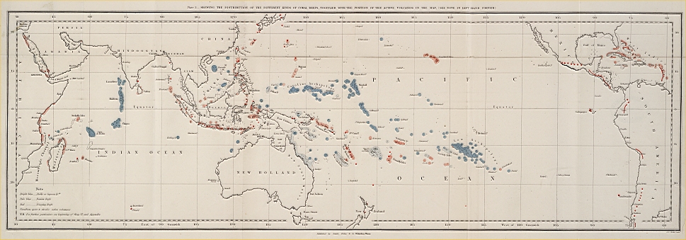
The principles, on which this map is coloured, are explained in the beginning of Chapter VI.; and the authorities for colouring each particular spot are detailed in the Appendix. The names printed in italics in the Index refer to the Appendix.
CONTENTS.
~~~~~~~~
CHAPTER I.
ATOLLS OR LAGOON ISLANDS.
SECTION I.—DESCRIPTION OF KEELING ATOLL.
Corals on the outer margin—Zone of Nulliporæ—Exterior reef—Islets—Coral-conglomerate—Lagoon—Calcareous sediment—Scari and Holuthuriæ subsisting on corals—Changes in the condition of the reefs and islets—Probable subsidence of the atoll—Future state of the Lagoon . . page 5 to 19
SECTION II.—GENERAL DESCRIPTION OF ATOLLS.
General form and size of atolls, their reefs and islets—External slope—Zone of Nulliporæ—Conglomerate—Depth of lagoons —Sediment—Reefs submerged wholly or in part—Breaches in the reef—Ledge-formed shores round certain lagoons—Conversion of lagoons into land…page 19 to 31
SECTION III.—ATOLLS OF THE MALDIVA ARCHIPELAGO—GREAT CHAGOS BANK.
Maldiva Archipelago—Ring-formed reefs marginal and central—Great depth in the lagoons of the southern atolls—Reefs in the lagoons all rising to the surface—Position of islets and breaches in the reefs, with respect to the prevalent winds and action of the waves—Destruction of islets—Connection in the position and submarine foundation of distinct atolls—The apparent disseverment of large atolls—The Great Chagos Bank—Its submerged condition and extraordinary structure……page 32 to 40
CHAPTER II.
BARRIER-REEFS.
Closely resemble in general form and structure atoll-reefs—Width and depth of the lagoon-channels—Breaches through the reef in front of valleys, and generally on the leeward side—Checks to the filling up of the lagoon-channels—Size and constitution of the encircled islands—Number of islands within the same reef—Barrier-reefs of New Caledonia and Australia—Position of the reef relative to the slope of the adjoining land—Probable great thickness of barrier-reefs…… page 41 to 50
CHAPTER III.
FRINGING OR SHORE REEFS.
Reefs of Mauritius—Shallow channel within the reef—Its slow filling up—Currents of water formed within it—Upraised reefs—Narrow fringing-reefs in
deep seas—Reefs on the coast of E. Africa and of Brazil—Fringing reefs in very shallow seas, round banks of sediment and on worn-down islands—Fringing reefs affected by currents of the sea—Coral coating the bottom of the sea, but not forming reefs…. page 51 to 59
CHAPTER IV.
ON THE DISTRIBUTION AND GROWTH OF CORAL REEFS.
SECTION I.—ON THE DISTRIBUTION OF CORAL REEFS, AND ON
THE CONDITIONS FAVOURABLE TO THEIR INCREASE . page 60 to 71
SECTION II.—ON THE RATE OF GROWTH OF CORAL-REEFS . page 71 to 79
SECTION III.—ON THE DEPTHS AT WHICH REEF-BUILDING POLYPIFERS CAN LIVE
….
page 80 to 87
CHAPTER V.
THEORY OF THE FORMATION OF THE DIFFERENT CLASSES OF CORAL REEFS.
The atolls of the large archipelagoes are not formed on submerged craters, or on banks of sediment—Immense areas interspersed with atolls—Their subsidence—The effects of storms and earthquakes on atolls—Recent changes in their state—The origin of barrier-reefs and of atolls—Their relative forms—The step-formed ledges and walls round the shores of some lagoons—The ring-formed reefs of the Maldiva atolls—The submerged condition of parts or of the whole of some annular reefs—The disseverment of large atolls—The union of atolls by linear reefs—The great Chagos Bank—Objections, from the area and amount of subsidence required by the theory, considered—The probable composition of the lower parts of atolls . . page 88 to 118
CHAPTER VI.
ON THE DISTRIBUTION OF CORAL REEFS WITH REFERENCE TO THE THEORY OF THEIR FORMATION.
Description of the coloured map—Proximity of atolls and barrier-reefs—Relation in form and position of atolls with ordinary islands—Direct evidence of subsidence difficult to be detected—Proofs of recent elevation where fringing reefs occur—Oscillations of level—Absence of active volcanos in the areas of subsidence—Immensity of the areas which have been elevated and have subsided—Their relation to the present distribution of the land—Areas of subsidence elongated, their intersection and alternation with those of elevation—Amount, and slow rate of the subsidence—Recapitulation . page 119 to 148
APPENDIX.
Containing a detailed description of the reefs and islands in the coloured map, Plate III……. page 151 to 205
GENERAL INDEX……207
INTRODUCTION.
THE object of this volume is to describe from my own observation and the works of others, the principal kinds of coral reefs, more especially those occurring in the open ocean, and to explain the origin of their peculiar forms. I do not here treat of the polypifers, which construct these vast works, except so far as relates to their distribution, and to the conditions favourable to their vigorous growth. Without any distinct intention to classify coral-reefs, most voyagers have spoken of them under the following heads: 'lagoon-islands,' or 'atolls,' 'barrier,' or 'encircling reefs' and 'fringing,' or 'shore reefs.' The lagoon-islands have received much the most attention; and it is not surprising, for every one must be struck with astonishment, when he first beholds one of these vast rings of coral-rock, often many leagues in diameter, here and there surmounted by a low verdant island with dazzling white shores, bathed on the outside by the foaming breakers of the ocean, and on the inside surrounding a calm expanse of water, which, from reflection, is of a bright but pale green colour. The naturalist will feel this astonishment more deeply after having examined the soft and almost gelatinous bodies of these apparently insignificant creatures, and when he knows that the solid reef increases only on the outer edge, which day and night is lashed by the breakers of an ocean never at rest. Well did François
B
Pyrard de Laval, in the year 1605, exclaim, "C'est une merueille de voir chacun de ces atollons, enuironné d'un grand banc de pierre tout autour, n'y ayant point d'artifice humain." The accompanying sketch of Whitsunday Island, in the S. Pacific, taken from Capt. Beechey's admirable Voyage, although excellent of its kind, gives but a faint idea of the singular aspect of one of these lagoon-islands.

Whitsunday Island is of small size, and the whole circle has been converted into land, which is a comparatively rare circumstance. As the reef of a lagoon-island generally supports many separate small islands, the word 'island,' applied to the whole, is often the cause of confusion; hence I have invariably used in this volume the term 'atoll,' which is the name given to these circular groups of coral islets by their inhabitants in the Indian Ocean, and is synonymous with 'lagoon-island.'
Barrier reefs, when encircling small islands, have been comparatively little noticed by voyagers; but they well deserve attention. In their structure they are little less marvellous than atolls, and they give a singular and most picturesque character to the scenery of the islands they surround. In the accompanying sketch, taken from the voyage of the Coquille, the reef is seen from within, from one of the high peaks of the island of Bolabola.* Here, as in Whitsunday island, the whole of that part of the reef which is
* I have taken the liberty of simplifying the foreground, and leaving out a mountainous island in the far distance.

visible is converted into land. This is a circumstance of rare occurrence; more usually a snow-white line of great breakers, with here and there an islet crowned by cocoa-nut trees, separates the smooth waters of the lagoon-like channel from the waves of the open sea. The barrier reefs of Australia and of New Caledonia, owing to their enormous dimensions, have excited much attention: in structure and form they resemble those encircling many of the smaller islands in the Pacific Ocean.
With respect to fringing, or shore reefs, there is little in their structure which needs explanation; and their name expresses their comparatively small extension. They differ from barrier-reefs in not lying so far from the shore, and in not having within a broad channel of deep water. Reefs also occur around submerged banks of sediment and of worn-down rock; and others are scattered quite irregularly where the sea is very shallow: these in most respects are allied to those of the fringing class, but they are of comparatively little interest.
I have given a separate chapter to each of the above classes, and have described some one reef or island, on which I possessed most information, as typical; and have afterwards compared it with others of a like kind. Although this classification is useful from being obvious, and from including most of the coral reefs existing in the open sea, it admits of a more fundamental division into barrier and atoll-formed reefs on the one hand, where there is a great apparent diffi-
B 2
culty with respect to the foundation on which they must first have grown; and into fringing reefs on the other, where, owing to the nature of the slope of the adjoining land, there is no such difficulty. The two blue tints and the red colour on the map (Plate III.) represent this main division, as explained in the beginning of the last chapter. In the Appendix, every existing coral reef, except some on the coast of Brazil not included in the map, is briefly described in geographical order, as far as I possessed information; and any particular spot may be found by consulting the Index.
Several theories have been advanced to explain the origin of atolls or lagoon-islands, but scarcely one to account for barrier-reefs. From the limited depths at which reef-building polypifers can flourish, taken into consideration with certain other circumstances, we are compelled to conclude, as it will be seen, that both in atolls and barrier-reefs, the foundation on which the coral was primarily attached, has subsided; and that during this downward movement, the reefs have grown upwards. This conclusion, it will be further seen, explains most satisfactorily the outline and general form of atolls and barrier-reefs, and likewise certain peculiarities in their structure. The distribution, also, of the different kinds of coral-reefs, and their position with relation to the areas of recent elevation, and to the points subject to volcanic eruptions, fully accord with this theory of their origin.*
* A brief account of my views on coral formations, now published in my Journal of Researches, was read May 31, 1837, before the Geological Society, and an abstract has appeared in the Proceedings.
CHAPTER I.
ATOLLS OR LAGOON-ISLANDS.
———
SECTION FIRST, KEELING ATOLL.
Corals on the outer margin—Zone of Nulliporæ—Exterior reef—Islets—Coral-conglomerate—Lagoon—Calcareous sediment—Scari and Holuthuriæ subsisting on corals—Changes in the condition of the reefs and islets—Probable subsidence of the atoll—Future state of the Lagoon.
KEELING or Cocos atoll is situated in the Indian Ocean, in 12° 5' S. and long. 90° 55' E.: a reduced chart of it from the survey of Capt. FitzRoy and the Officers of H.M.S. Beagle, is given in Plate I. fig. 10. The greatest width of this atoll is nine miles and a half. Its structure is in most respects characteristic of the class to which it belongs, with the exception of the shallowness of the lagoon. The accompanying woodcut represents a vertical section, supposed to be drawn at low water from the outer coast across one of the low islets (one being taken of average dimensions) to within the lagoon.
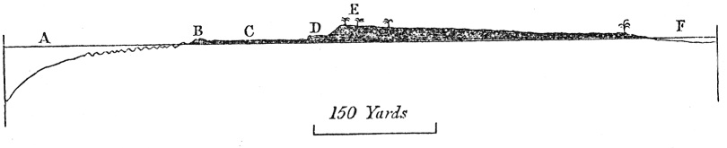
A—Level of the sea at low water: where the
letter A is placed, the depth is 25 fathoms, and the distance rather
more than 150 yards from the edge of the reef.
B—Outer edge of that flat part of the reef, which dries at low
water: the edge either consists of a convex mound, as represented, or
of rugged points, like those a little farther seaward, beneath the
water.
C—A flat of coral-rock, covered at high water.
D—A low projecting ledge of brecciated coral-rock, washed by
the waves at high water.
E—A slope of loose fragments, reached by the sea only during
gales: the upper part, which is from six to twelve feet high, is
clothed with vegetation. The surface of the islet gently slopes to the
lagoon.
F—Level of the lagoon at low-water.
The section is true to the scale in a horizontal line, but it could not be made so in a vertical one, as the average greatest height of the land is only between six and twelve feet above high-water mark. I will describe the section, commencing with the outer margin. I must first observe that the reef-building polypifers, not being tidal animals, require to be constantly submerged or washed by the breakers. I was assured by Mr. Liesk, a very intelligent resident on these islands, as well as by some chiefs at Tahiti (Otaheite), that an exposure to the rays of the sun for a very short time invariably causes their destruction. Hence it is possible only under the most favourable circumstances, afforded by an unusually low tide and smooth water, to reach the outer margin, where the coral is alive. I succeeded only twice in gaining this part, and found it almost entirely composed of a living Porites, which forms great irregularly rounded masses (like those of an Astræa, but larger) from four to eight feet broad, and little less in thickness. These mounds are separated from each other by narrow crooked channels, about six feet deep, most of which intersect the line of reef at right angles. On the furthest mound, which I was able to reach by the aid of a leaping-pole, and over which the sea broke with some violence, although the day was quite calm and the tide low, the polypifers in the uppermost cells were all dead, but between three and four inches lower down on its side they were living, and formed a projecting border round the upper and dead surface. The coral being thus checked in its upward growth, extends laterally, and hence most of the masses, especially those a little further inwards, had broad flat dead summits. On the other hand I could see, during the recoil of the breakers, that a few yards further seaward, the whole convex surface of the Porites was alive: so that the point where we were standing was almost on the exact upward and shoreward limit of existence of those corals which form the outer margin of the reef. We shall presently see that there are other organic productions, fitted to bear a somewhat longer exposure to the air and sun.
Next, but much inferior in importance to the Porites, is the Millepora complanata.* It grows in thick vertical plates, intersecting each other at various angles, and forms an exceedingly strong honeycombed mass, which generally affects a circular form, the marginal plates alone being alive. Between these plates and in the protected crevices on the reef, a multitude of branching zoophytes and other productions flourish, but the Porites and Millepora alone seem able to resist the fury of the breakers on its upper and outer edge: at the depth of a few fathoms other kinds of stony corals live. Mr. Liesk, who was intimately acquainted with every part of this reef, and likewise with that of North Keeling atoll, assured me that these corals invariably compose the outer margin. The lagoon is inhabited by quite a distinct set of corals, generally brittle and thinly branched; but a Porites, apparently of the same species with that on the outside, is found there, although it does not seem to thrive, and certainly does not attain the thousandth part in bulk of the masses opposed to the breakers.
The woodcut shews the form of the bottom off the reef: the water deepens for a space between one and two hundred yards wide, very gradually to 25 fathoms (A in section), beyond which the sides plunge into the unfathomable ocean at an angle of 45°.† To the depth of ten or twelve fathoms, the bottom is exceedingly rugged, and seems formed of great masses of living coral, similar to those on the margin. The arming of the lead here invariably came up quite clean, but deeply indented, and chains and anchors which were lowered,
* This Millepora, (Palmipora of Blainville,) as well as the M. alcicornis, possesses the singular property of stinging the skin where it is delicate, as on the face and arm.
† The soundings from which this section is laid down were taken with great care by Capt. FitzRoy himself: he used a bell-shaped lead, having a diameter of four inches, and the armings each time were cut off and brought on board for me to examine. The arming is a preparation of tallow, placed in the concavity at the bottom of the lead. Sand, and even small fragments of rock will adhere to it; and if the bottom be of rock, it brings up an exact impression of its surface.
in the hopes of tearing up the coral, were broken. Many small fragments, however, of Millepora alcicornis were brought up; and on the arming from an eight-fathom cast, there was a perfect impression of an Astræa, apparently alive. I examined the rolled fragments cast on the beach during gales, in order further to ascertain what corals grew outside the reef. The fragments consisted of many kinds, of which the Porites already mentioned and a Madrepora, apparently the M. corymbosa, were the most abundant. As I searched in vain in the hollows on the reef and in the lagoon, for a living specimen of this Madrepore, I conclude that it is confined to a zone outside, and beneath the surface, where it must be very abundant. Fragments of the Millepora alcicornis and of an Astræa were also numerous; the former is found, but not in proportionate numbers, in the hollows on the reef; but the Astræa I did not see living. Hence we may infer, that these are the kinds of coral which form the rugged sloping surface, (represented in the wood cut by an uneven line) round and beneath the external margin. Between 12 and 20 fathoms the arming came up an equal number of times smoothed with sand, and indented with coral: an anchor and lead were lost at the respective depths of 13 and 16 fathoms. Out of twenty-five soundings, taken at a greater depth than 20 fathoms, every one shewed that the bottom was covered with sand; whereas at a less depth than 12 fathoms, every sounding shewed that it was exceedingly rugged, and free from all extraneous particles. Two soundings were obtained at the depth of 360 fathoms, and several between 200 and 300 fathoms. The sand brought up from these depths consisted of finely triturated fragments of stony zoophytes, but not, as far as I could distinguish, of a particle of any lamelliform genus: fragments of shells were rare.
At a distance of 2200 yards from the breakers, Captain FitzRoy found no bottom with a line 7200 feet in length; hence the submarine slope of this coral formation is steeper than that of any volcanic cone. Off the mouth of the lagoon, and likewise off the northern point of the atoll, where the
currents act violently, the inclination, owing to the accumulation of sediment, is less. As the arming of the lead from all the greater depths showed a smooth sandy bottom, I at first concluded that the whole consisted of a vast conical pile of calcareous sand, but the sudden increase of depth at some points, and the circumstance of the line having been cut, as if rubbed, when between 500 and 600 fathoms were out, indicate the probable existence of submarine cliffs.
On the margin of the reef, close within the line where the upper surface of the Porites and of the Millepora is dead, three species of Nullipora flourish. One grows in thin sheets, like a lichen on old trees; the second in stony knobs, as thick as a man's finger, radiating from a common centre; and the third, which is less common, in a moss-like reticulation of thin, but perfectly rigid branches.* The three species occur either separately or mingled together; and they form by their successive growth a layer two or three feet in thickness, which in some cases is hard, but where formed of the lichen-like kind, readily yields an impression to the hammer: the surface is of a reddish colour. These Nulliporæ, although able to exist above the limit of true corals, seem to require to be bathed during the greater part of each tide by breaking water, for they are not found in any abundance in the protected hollows on the back part of the reef, where they might be immersed either during the whole or an equal proportional time of each tide. It is remarkable that organic productions of such extreme simplicity, for the Nulliporæ undoubtedly belong to one of the lowest classes of the vegetable kingdom, should be limited to a zone so peculiarly circumstanced. Hence the layer composed by their growth, merely fringes the reef for a
* This last species is of a beautiful bright peach blossom colour. Its branches are about as thick as crow-quills; they are slightly flattened and knobbed at the extremities. The extremities only are alive and brightly coloured. The two other species are of a dirty purplish white. The second species is extremely hard; its short knob-like branches are cylindrical, and do not grow thicker at their extremities.
space of about 20 yards in width, either under the form of separate mammillated projections, where the outer masses of coral are separate, or more commonly, where the corals are united into a solid margin, as a continuous smooth convex mound, (B in wood-cut,) like an artificial breakwater. Both the mound and mammillated projections stand about three feet higher than any other part of the reef, by which term I do not include the islets, formed by the accumulation of rolled fragments. We shall hereafter see that other coral reefs are protected by a similar thick growth of Nulliporæ on the outer margin, the part most exposed to the breakers, and this must effectually aid in preserving it from being worn down.
The wood-cut represents a section across one of the islets on the reef, but if all that part which is above the level of C were removed, the section would be that of the simple reef, as it occurs where no islet has been formed. It is this reef which essentially forms the atoll. It is a ring, enclosing the lagoon on all sides except at the northern end, where there are two open spaces, through one of which ships can enter. The reef varies in width from 250 to 500 yards; its surface is level, or very slightly inclined towards the lagoon, and at high-tide the sea breaks entirely over it: the water at low tide thrown by the breakers on the reef, is carried by the many narrow and shoal gullies or channels on its surface, into the lagoon: a return stream sets out of the lagoon through the main entrance. The most frequent coral in the hollows on the reef is Pocillopora verrucosa, which grows in short sinuous plates, or branches, and when alive is of a beautiful pale lake-red: a Madrepora, closely allied or identical with M. pocillifera is also common. As soon as an islet is formed, and the waves are prevented breaking entirely over the reef, the channels and hollows in it become filled up with cemented fragments, and its surface is converted into a hard smooth floor, (C of wood-cut), like an artificial one of freestone. This flat surface varies in width from 100 to 200, or even 300 yards, and is strewed with a
few large fragments of coral torn up during gales: it is uncovered only at low water. I could with difficulty, and only by the aid of a chisel, procure chips of rock from its surface, and therefore could not ascertain how much of it is formed by the aggregation of detritus, and how much by the outward growth of mounds of corals, similar to those now living on the margin. Nothing can be more singular than the appearance at low-tide of this 'flat' of naked stone, especially where it is externally bounded by the smooth convex mound of Nulliporæ, appearing like a breakwater built to resist the waves, which are constantly throwing over it sheets of foaming water. The characteristic appearance of this 'flat' is shown in the foregoing wood-cut of Whitsunday Atoll.
The islets on the reef are first formed between 200 and 300 yards from its outer edge, through the accumulation of a pile of fragments, thrown together by some unusually strong gale. Their ordinary width is under a quarter of a mile, and their length varies from a few yards to several miles. Those on the S.E. and windward side of the atoll, increase solely by the addition of fragments on their outer side; hence the loose blocks of coral, of which their surface is composed, as well as the shells mingled with them, almost exclusively consist of those kinds which live on the outer coast. The highest part of the islets (excepting hillocks of blown sand, some of which are 30 feet high), is close to the outer beach (E of the wood-cut) and averages from six to ten feet above ordinary high-water mark. From the outer beach the surface slopes gently to the shores of the lagoon, which no doubt has been caused by the breakers, the further they have rolled over the reef, having had less power to throw up fragments. The little waves of the lagoon heap up sand and fragments of thinly-branched corals on the inner side of the islets on the leeward side of the atoll; and these islets are broader than those to windward, some being even 800 yards in width; but the land thus added is very low. The fragments be-
neath the surface are cemented into a solid mass, which is exposed as a ledge (D of the wood-cut), projecting some yards in front of the outer shore, and from two to four feet high. This ledge is just reached by the waves at ordinary high-water: it extends in front of all the islets, and everywhere has a water-worn and scooped appearance. The fragments of coral which are occasionally cast on the 'flat' are during gales of unusual violence swept together on the beach, where the waves each day at high-water tend to remove and gradually wear them down; but the lower fragments having become firmly cemented together by the percolation of calcareous matter, resist the daily tides longer, and hence project as a ledge. The cemented mass is generally of a white colour, but in some few parts reddish from ferruginous matter: it is very hard, and is sonorous under the hammer: it is obscurely divided by seams, dipping at a small angle seaward: it consists of fragments of the corals which grow on the outer margin, some quite and others partially rounded, some small and others between two and three feet across; and of masses of previously-formed conglomerate, torn up, rounded, and re-cemented: or it consists of a calcareous sandstone, entirely composed of rounded particles, generally almost blended together, of shells, corals, the spines of echini, and other such organic bodies;—rocks, of this latter kind, occur on many shores, where there are no coral-reefs. The structure of the coral in the conglomerate has generally been much obscured by the infiltration of spathose calcareous matter; and I collected a very interesting series, beginning with fragments of unaltered coral, and ending with others, where it was impossible to discover with the naked eye any trace of organic structure. In some specimens I was unable, even with the aid of a lens, and by wetting them, to distinguish the boundaries of the altered coral and spathose limestone. Many even of the blocks of coral lying loose on the beach, had their central parts altered and infiltrated.
The lagoon alone remains to be described; it is much
shallower than that of most atolls of considerable size. The southern part is almost filled up with banks of mud and fields of coral, both dead and alive; but there are considerable spaces, between three and four fathoms, and smaller basins from eight to ten fathoms deep. Probably about half its area consists of sediment, and half of coral-reefs. The corals composing these reefs have a very different aspect from those on the outside: they are very numerous in kind, and most of them are thinly branched. Meandrina, however, lives in the lagoon, and great rounded masses of this coral are numerous, lying quite or almost loose on the bottom. The other commonest kinds consist of three closely allied species of true Madrepora in thin branches; of Seriatapora subulata; two species of Porites* with cylindrical branches, one of which forms circular clumps, with the exterior branches only alive; and lastly, a coral something like an Explanaria, but with stars on both surfaces, growing in thin, brittle, stony, foliaceous expansions, especially in the deeper basins of the lagoon. The reefs on which these corals grow are very irregular in form, are full of cavities, and have not a solid flat surface of dead rock, like that surrounding the lagoon; nor can they be nearly so hard, for the inhabitants made with crowbars a channel of considerable length through these reefs, in which a schooner, built on the S.E. islet was floated out. It is a very interesting circumstance, pointed out to us by Mr. Liesk, that this channel, although made less than ten years before our visit, was then, as we saw, almost choked up with living coral, so that fresh excavations would be absolutely necessary to allow another vessel to pass through it.
The sediment from the deepest parts in the lagoon, when wet, appeared chalky, but when dry, like very fine
* This Porites has somewhat the habit of P. clavaria, but the branches are not knobbed at their ends. When alive it is of a yellow colour, but after having been washed in fresh water and placed to dry, a jet-black slimy substance exuded from the entire surface, so that the specimen now appears as if it had been dipped in ink.
sand. Large soft banks of similar, but even finer grained mud, occur on the S.E. shore of the lagoon, affording a thick growth of a Fucus, on which turtle feed: this mud, although discoloured by vegetable matter, appears from its entire solution in acids to be purely calcareous. I have seen in the Museum of the Geological Society, a similar but more remarkable substance, brought by Lieut. Nelson from the reefs of Bermuda, which, when shewn to several experienced geologists, was mistaken by them for true chalk. On the outside of the reef much sediment must be formed by the action of the surf on the rolled fragments of coral; but, in the calm waters of the lagoon, this can take place only in a small degree. There are, however, other and unexpected agents at work here: large shoals of two species of Scarus, one inhabiting the surf outside the reef and the other the lagoon, subsist entirely, as I was assured by Mr. Liesk the intelligent resident before referred to, by browsing on the living polypifers. I opened several of these fish, which are very numerous and of considerable size, and I found their intestines distended by small pieces of coral, and finely ground calcareous matter. This must daily pass from them as the finest sediment; much also must be produced by the infinitely numerous vermiform and molluscous animals, which make cavities in almost every block of coral. Dr. J. Allan of Forres, who has enjoyed the best means of observation, informs me in a letter, that the Holuthuriæ (a family of Radiata), subsist on living coral; and the singular structure of bone within the anterior extremity of their bodies, certainly appears well adapted for this purpose. The number of the species of Holuthuria, and of the individuals which swarm on every part of these coral-reefs, is extraordinarily great; and many ship-loads are annually freighted, as is well known, for China with the trepang, which is a species of this genus. The amount of coral yearly consumed, and ground down into the finest mud, by these several creatures, and probably by many other kinds, must be immense. These facts are, however, of more im-
portance in another point of view, as showing us that there are living checks to the growth of coral-reefs, and that the almost universal law of 'consume and be consumed,' holds good even with the polypifers forming those massive bulwarks, which are able to withstand the force of the open ocean.
Considering that Keeling atoll, like other coral formations, has been entirely formed by the growth of organic beings, and the accumulation of their detritus, one is naturally led to enquire, how long it has continued, and how long it is likely to continue, in its present state. Mr. Liesk informed me that he had seen an old chart in which the present long island on the S.E. side was divided by several channels into as many islets; and he assures me that the channels can still be distinguished by the smaller size of the trees on them. On several islets, also, I observed that only young cocoa-nut trees were growing on the extremities; and that older and taller trees rose in regular succession behind them; which shows that these islets have very lately increased in length. In the upper and south-eastern part of the lagoon, I was much surprised by finding an irregular field of at least a mile square of branching corals, still upright, but entirely dead. They consisted of the species already mentioned; they were of a brown colour, and so rotten, that in trying to stand on them, I sank half way up the leg, as it through decayed brushwood. The tops of the branches were barely covered by water at the time of lowest tide. Several facts having led me to disbelieve in any elevation of the whole atoll, I was at first unable to imagine what cause could have killed so large a field of coral. Upon reflection, however, it appeared to me that the closing up of the above mentioned channels would be a sufficient cause; for before this, a strong breeze by forcing water through them into the head of the lagoon, would tend to raise its level. But now this cannot happen, and the inhabitants observe that the tide rises to a less height, during a high S.E. wind, at the head than at the mouth of the lagoon. The corals, which, under the former
condition of things, had attained the utmost possible limit of upward growth, would thus occasionally be exposed for a short time to the sun, and be killed.
Besides the increase of dry land, indicated by the foregoing facts, the exterior solid reef appears to have grown outwards. On the western side of the atoll, the 'flat' lying between the margin of the reef and the beach, is very wide: and in front of the regular beach with its conglomerate basis, there is, in most parts, a bed of sand and loose fragments with trees growing out of it, which apparently is not reached even by the spray at high water. It is evident some change has taken place since the waves formed the inner beach: that they formerly beat against it with violence was evident, from a remarkably thick and water-worn point of conglomerate at one spot, now protected by vegetation and a bank of sand; that they beat against it in the same peculiar manner in which the swell from windward now obliquely curls round the margin of the reef, was evident from the conglomerate having been worn into a point projecting from the beach in a similarly oblique manner. This retreat in the line of action of the breakers might result, either from the surface of the reef in front of the islets having been submerged at one time, and afterward having grown upwards, or from the mounds of coral on the margin having continued to grow outwards. That an outward growth of this part is in process, can hardly be doubted from the fact already mentioned of the mounds of Porites with their summits apparently lately killed, and their sides only three or four inches lower down thickened by a fresh layer of living coral. But there is a difficulty on this supposition which I must not pass over. If the whole, or a large part of the 'flat,' had been formed by the outward growth of the margin, each successive margin would naturally have been coated by the Nulliporæ, and so much of the surface would have been of equal height with the existing zone of living Nulliporæ: this is not the case, as may be seen in the wood-cut. It is, however, evident from the abraded state of the 'flat,' with its original
inequalities filled up, that its surface has been much modified; and it is possible that the hinder portions of the zone of Nulliporæ, perishing as the reef grows outwards, might be worn down by the surf. If this has not taken place, the reef can in no part have increased outwards in breadth since its formation, or at least since the Nulliporæ formed the convex mound on its margin: for the zone thus formed, and which stands between two and three feet above the other parts of the reef, is nowhere much above twenty yards in width.
Thus far we have considered facts, which indicate, with more or less probability, the increase of the atoll in its different parts: there are others having an opposite tendency. On the S.E. side, Lieut. Sulivan, to whose kindness I am indebted for many interesting observations, found the conglomerate projecting on the reef nearly fifty yards in front of the beach: we may infer from what we see in all others parts of the atoll, that the conglomerate was not originally so much exposed but formed the base of an islet, the front and upper part of which has since been swept away. The degree to which the conglomerate, round nearly the whole atoll, has been scooped, broken up and the fragments cast on the beach, is certainly very surprising, even on the view that it is the office of occasional gales to pile up fragments, and of the daily tides to wear them away. On the western side, also, of the atoll, where I have described a bed of sand and fragments with trees growing out of it, in front of an old beach, it struck both Lieut. Sulivan and myself, from the manner in which the trees were being washed down, that the surf had lately recommenced an attack on this line of coast. Appearances indicating a slight encroachment of the water on the land, are plainer within the lagoon: I noticed in several places, both on its windward and leeward shores, old cocoa-nut trees falling with their roots undermined, and the rotten stumps of others on the beach, where the inhabitants assured us the cocoa-nut could not now grow. Capt. FitzRoy pointed out to me, near the settlement, the foundation posts of a shed, now washed by every tide, but which the inhabitants
C
stated, had seven years before stood above high water-mark. In the calm waters of the lagoon, directly connected with a great, and therefore stable ocean, it seems very improbable that a change in the currents, sufficiently great to cause the water to eat into the land on all sides, should have taken place within a limited period. From these considerations I inferred, that probably the atoll had lately subsided to a small amount; and this inference was strengthened by the circumstance, that in 1834, two years before our visit, the island had been shaken by a severe earthquake, and by two slighter ones during the ten previous years. If, during these subterranean disturbances, the atoll did subside, the downward movement must have been very small, as we must conclude from the fields of dead coral still lipping the surface of the lagoon, and from the breakers on the western shore not having yet regained the line of their former action. The subsidence must, also, have been preceded by a long period of rest, during which the islets extended to their present size, and the living margin of the reef grew either upwards, or as I believe outwards, to its present distance from the beach.
Whether this view be correct or not, the above facts are worthy of attention, as showing how severe a struggle is in progress on these low coral-formations between the two nicely balanced powers of land and water. With respect to the future state of Keeling atoll, if left undisturbed, we can see that the islets may still extend in length; but as they cannot resist the surf until broken by rolling over a wide space, their increase in breadth must depend on the increasing breadth of the reef; and this must be limited by the steepness of the submarine flanks, which can be added to only by sediment derived from the wear and tear of the coral. From the rapid growth of the coral in the channel cut for the schooner, and from the several agents at work in producing fine sediment, it might be thought that the lagoon would necessarily become quickly filled up. Some of this sediment, however, is transported into the open sea, as appears from the soundings off the mouth of the lagoon, instead of being deposited within it.
The deposition, moreover, of sediment, checks the growth of coral reefs, so that these two agencies cannot act together with full effect in filling it up. We know so little of the habits of the many different species of corals, which form the lagoon-reefs, that we have no more reason for supposing that their whole surface would grow up as quickly as the coral did in the schooner-channel, than for supposing that the whole surface of a peat-moss would increase as quickly as parts are known to do in holes, where the peat has been cut away. These agencies, nevertheless, tend to fill up the lagoon; but in proportion as it becomes shallower, so must the polypifers be subject to many injurious agencies, such as impure water and loss of food. For instance, Mr. Liesk informed me, that some years before our visit unusually heavy rain killed nearly all the fish in the lagoon, and probably the same cause would likewise injure the corals. The reefs also, it must be remembered, cannot possibly rise above the level of the lowest spring-tide, so that the final conversion of the lagoon into land must be due to the accumulation of sediment; and in the midst of the clear water of the ocean, and with no surrounding high land, this process must be exceedingly slow.
SECTION SECOND.
General form and size of atolls, their reefs and islets—External slope—Zone of Nulliporæ—Conglomerate—Depth of Lagoons—Sediment—Reefs submerged wholly or in part—Breaches in the reef—Ledge-formed shores round certain lagoons—Conversion of lagoons into land.
I WILL here give a sketch of the general form and structure of many atolls and atoll-formed reefs which occur in the Pacific and Indian oceans, comparing them with Keeling atoll. The Maldiva atolls and the Great Chagos Bank differ in so many respects, that I shall devote to them, besides occasional references, a third section of this chapter. Keeling
C 2
atoll may be considered as of moderate dimensions and of regular form. Of the thirty-two islands surveyed by Capt. Beechey in the Low Archipelago, the longest was found to be thirty miles, and the shortest less than a mile; but Vliegen atoll, situated in another part of the same group, appears to be sixty miles long and twenty broad. Most of the atolls in this group are of an elongated form; thus Bow Island is thirty miles in length, and on an average only six in width (See Fig. 4, Plate I.), and Clermont Tonnere has nearly the same proportions. In the Marshall Archipelago (the Ralick and Radack group of Kotzebue) several of the atolls are more than thirty miles in length, and Rimsky Korsacoff is fifty-four long, and twenty wide at the broadest part of its irregular outline. Most of the atolls in the Maldiva Archipelago are of great size, one of them (which, however, bears a double name) measured in a medial and slightly curved line, is no less than eighty-eight geographical miles long, its greatest width being under twenty, and its least only nine-and-a-half miles. Some atolls have spurs projecting from them; and in the Marshall group there are atolls united together by linear reefs, for instance Menchioff Island, (See Fig. 3, Plate II.) which is sixty miles in length, and consists of three loops tied together. In far the greater number of cases an atoll consists of a simple elongated ring, with its outline moderately regular.
The average width of the annular reef may be taken at about a quarter of a mile. Capt. Beechey* says that in the atolls of the Low Archipelago it exceeded in no instance half a mile. The description given of the structure and proportional dimensions of the reef and islets of Keeling atoll, appears to apply perfectly to nearly all the atolls in the Pacific and Indian oceans. The islets are first formed some way back either on the projecting points of the reef, especially if its form be angular, or on the sides of the main entrances into the lagoon—that is in both cases, on points where the breakers can act during gales of wind in somewhat different
* Beechey's Voyage to the Pacific and Beering's Straits, chap. viii.
directions, so that the matter thrown up from one side may accumulate against that before thrown up from another. In Lutkè's chart of the Caroline atolls, we see many instances of the former case; and the occurrence of islets, as if placed for beacons, on the points where there is a gateway or breach through the reef, has been noticed by several authors. There are some atoll-formed reefs, rising to the surface of the sea and partly dry at low water, on which from such cause islets have never been formed; and there are others, on which they have been formed, but have subsequently been worn away. In atolls of small dimensions the islets frequently become united into a single horse-shoe or ring-formed strip; but Diego Garcia, although an atoll of considerable size, being thirteen miles and a half in length, has its lagoon entirely surrounded, except at the northern end, by a belt of land, on an average a third of a mile in width. To show how small the total area of the annular reef and the land is in islands of this class, I may quote a remark from the voyage of Lutkè, namely, that if the forty-three rings, or atolls, in the Caroline Archipelago, were put one within another, and over a steeple in the centre of St. Petersburg, the whole would not cover that city and its suburbs.
The form of the bottom off Keeling atoll, which gradually slopes to about twenty fathoms at the distance of between one and two hundred yards from the edge of the reef, and then plunges at an angle of 45° into unfathomable depths, is exactly the same* with that of the sections of the atolls in the Low Archipelago given by Capt. Beechey. The nature, however, of the bottom seems to differ, for this officer† informs
* The form of the bottom round the Marshall atolls in the Northern Pacific is probably similar: Kotzebue (First Voyage, vol. ii. p. 16.) says, "We had at a small distance from the reef, forty fathoms depth, which increased a little further so much that we could find no bottom."
† I must be permitted to express my obligation to Captain Beechey, for the very kind manner in which he has given me information on several points, and to own the great assistance I have derived from his excellent published work.
me that all the soundings, even the deepest, were on coral, but he does not know whether dead or alive. The slope round Christmas atoll, (Lat. 1° 4' N., 157° 45' W.) described by Cook,* is considerably less; at about half a mile from the edge of the reef, the average depth was about fourteen fathoms on a fine sandy bottom, and at a mile, only between twenty and forty fathoms. It has no doubt been owing to this gentle slope, that the strip of land surrounding its lagoon, has increased in one part to the extraordinary width of three miles: it is formed of successive ridges of broken shells and corals, like those on the beach. I know of no other instance of such width in the reef of an atoll; but Mr. F. D. Bennett informs me that the inclination of the bottom round Caroline atoll in the Pacific, is like that off Christmas island, very gentle. Off the Maldiva and Chagos atolls, the inclination is much more abrupt; thus at Heawandoo Pholo, Lieut. Powell† found 50 and 60 fathoms close to the edge of the reef, and at 300 yards distance there was no bottom with a 300 yard line. Capt. Moresby informs me, that at 100 fathoms from the mouth of the lagoon of Diego Garcia, he found no bottom with 150 fathoms: this is the more remarkable, as the slope is generally less abrupt in front of channels through a reef, owing to the accumulation of sediment. At Egmont Island, also, at 150 fathoms from the reef, soundings were struck with 150 fathoms. Lastly, at Cardoo atoll, only sixty yards from the reef, no bottom was obtained, as I am informed by Capt. Moresby, with a line of two hundred fathoms! The currents run with great force round these atolls, and where they are strongest, the inclination appears to be most abrupt. I am informed by the same authority, that wherever soundings were obtained off these islands, the bottom was invariably sandy: nor was there any reason to suspect the existence
* Cook's Third Voyage, vol. ii. chap. 10.
† This fact is taken from a MS. account of these groups lent me by Capt. Moresby. See also Capt. Moresby's paper on the Maldiva atolls in the Geographical Journal, vol. v. p. 401.
of submarine cliffs, as there was at Keeling Island.* Here then occurs a difficulty;—can sand accumulate on a slope, which, in some cases, appears to exceed fifty-five degrees? It must be observed, that I speak of slopes where soundings were obtained, and not of such cases, as that of Cardoo, where the nature of the bottom is unknown, and where its inclination must be nearly vertical. M. Élie de Beaumont† has argued, and there is no higher authority on this subject, from the inclination at which snow slides down in avalanches, that a bed of sand or mud cannot be formed at a greater angle than thirty degrees. Considering the number of soundings on sand, obtained round the Maldiva and Chagos atolls, which appear to indicate a greater angle, and the extreme abruptness of the sand-banks in the West Indies as will be mentioned in the Appendix, I must conclude that the adhesive property of wet sand counteracts its gravity, in a much greater ratio than has been allowed for by M. Élie de Beaumont. From the facility with which calcareous sand becomes agglutinated, it is not necessary to suppose that the bed of loose sand is thick.
Capt. Beechey has observed, that the submarine slope is much less at the extremities of the more elongated atolls in the Low Archipelago, than at their sides; in speaking of Ducie's Island he says‡ the buttress, as it may be called, which "has the most powerful enemy (the S.W. swell) to oppose, is carried out much further, and with less abruptness, than the other." In some cases, the less inclination of a certain part of the external slope, for instance of the
* Off some of the islands in the Low Archipelago the bottom appears to descend by ledges. Off Elizabeth Island, which, however, consists of raised coral, Capt. Beechey (p. 45, quarto ed.) describes three ledges: the first had an easy slope from the beach to a distance of about fifty yards; the second extended two hundred yards with twenty-five fathoms on it, and then ended abruptly, like the first; and immediately beyond this there was no bottom with two hundred fathoms.
† Mémoires pour servir à une description Géolog. de France, tome iv. p. 216.
‡ Beechey's Voyage, 4to ed. p. 44.
northern extremities of the two Keeling atolls, is caused by a prevailing current which there accumulates a bed of sand. Where the water is perfectly tranquil, as within a lagoon, the reefs generally grow up perpendicularly, and sometimes even overhang their bases: on the other hand, on the leeward side of Mauritius, where the water is generally tranquil although not invariably so, the reef is very gently inclined. Hence it appears that the exterior angle varies much; nevertheless, in the close similarity in form between the sections of Keeling atoll and of the atolls in the Low Archipelago, in the general steepness of the reefs of the Maldiva and Chagos atolls, and in the perpendicularity of those rising out of water always tranquil, we may discern the effects of uniform laws; but from the complex action of the surf and currents, on the growing powers of the coral and on the deposition of sediment, we can by no means follow out all the results.
Where islets have been formed on the reef, that part which I have sometimes called the 'flat,' and which is partly dry at low water, appears similar in every atoll. In the Marshall group in the N. Pacific, it may be inferred from Chamisso's description, that the reef, where islets have not been formed on it, slopes gently from the external margin to the shores of the lagoon: Flinders states that the Australian barrier has a similar inclination inwards, and I have no doubt it is of general occurrence, although, according to Ehrenberg, the reefs of the Red Sea offer an exception. Chamisso observes that "the red colour of the reef (at the Marshall atolls) under the breakers is caused by a Nullipora, which covers the stone wherever the waves beat; and, under favourable circumstances, assumes a stalactitical form,"—a description perfectly applicable to the margin of Keeling atoll.* Although Chamisso
* Kotzebue's First Voyage, vol. iii. p. 142. Near Porto Praya, in the Cape de Verd Islands, some basaltic rocks, lashed by no inconsiderable surf, were completely enveloped with a layer of Nullipora. The entire surface over many square inches, was coloured of a peach-blossom red; the layer, however, was of no greater thickness than paper. Another
does not state that the masses of Nulliporæ form points or a mound, higher than the flat, yet I believe that this is the case; for Kotzebue,* in another part, speaks of the rocks on the edge of the reef "as visible for about two feet at low water," and these rocks we may feel quite certain are not formed of true coral.† Whether a smooth convex mound of Nulliporæ, like that which appears as if artificially constructed to protect the margin of Keeling Island, is of frequent occurrence round atolls, I know not; but we shall presently meet with it, under precisely the same form, on the outer edge of the 'barrier reefs' which encircle the Society Islands.
There appears to be scarcely a feature in the structure of Keeling reef, which is not of common, if not of universal occurrence, in other atolls. Thus Chamisso describes‡ a layer of coarse conglomerate, outside the islets round the Marshall atolls, which "appears on its upper surface uneven and eaten away." From drawings, with appended remarks, of Diego Garcia in the Chagos group and of several of the Maldiva atolls, shown me by Captain Moresby§, it is evident that their outer coasts are subject to the same round of decay and renovation as those of Keeling atoll. From the description of the atolls in the Low Archipelago, given in Capt.
kind, in the form of projecting knobs, grew in the same situation. These Nulliporæ are closely related to those described on the coral-reefs, but I believe are of different species.
* Kotzebue's First Voyage, vol. ii. p. 16. Lieut. Nelson in his excellent memoir in the Geological Transactions, (vol. ii p. 105.) alludes to the rocky points mentioned by Kotzebue, and infers that they consist of Serpulæ, which compose incrusting masses on the reefs of Bermudas, as they likewise do on a sandstone bar off the coast of Brazil, (which I have described in London Phil. Journ. Oct. 1841). These masses of Serpulæ hold the same position, relatively to the action of the sea, with the Nulliporæ on the coral-reefs in the Indian and Pacific Oceans.
† Capt. Moresby, in his valuable paper "on the Northern Atolls of Maldivas," (Geographical Journal, vol. v.), says that the edges of the reefs there stand above water at low spring tides.
‡ Kotzebue's First Voyage, vol. iii p. 144.
§ See also Moresby on the Northern atolls of the Maldivas, Geographical Journal, vol. v. p. 400.
Beechey's Voyage, it is not apparent that any conglomerate coral-rock was there observed.
The lagoon in Keeling atoll is shallow: in the atolls of the Low Archipelago the depth varies from 20 to 38 fathoms, and in the Marshal Group, according to Chamisso, from 30 to 35: in the Caroline atolls it is only a little less. Within the Maldiva atolls there are large spaces with 45 fathoms, and some soundings are laid down of 49 fathoms. The greater part of the bottom in most lagoons, is formed of sediment; large spaces have exactly the same depth, or the depth varies so insensibly, that it is evident that no other means, excepting aqueous deposition, could have levelled the surface so equally. In the Maldiva atolls this is very conspicuous, and likewise in some of the Caroline and Marshall Islands. In the former large spaces consist of sand and soft clay; and Kotzebue speaks of clay having been found within one of the Marshall atolls. No doubt this clay is calcareous mud, similar to that at Keeling Island, and to that at Bermuda already referred to, as undistinguishable from disintegrated chalk, and which Lieut. Nelson says is called there pipe-clay.*
Where the waves act with unequal force on the two sides of an atoll, the islets appear to be first formed, and are generally of greater continuity on the more exposed shore. The islets, also, which are placed to leeward, are in most parts of the Pacific liable to be occasionally swept entirely away by gales, equalling hurricanes in violence, which blow in an opposite direction to the ordinary trade-wind. The absence of the
* I may here observe that on the coast of Brazil, where there is much coral, the soundings near the land are described by Admiral Roussin, in the Pilote du Brésil, as siliceous sand, mingled with much finely comminuted particles of shells and coral. Further in the offing, for a space of 1300 miles along the coast, from the Abrolhos islands to Maranham, the bottom in many places is composed of "tuf blanc, mêlé ou formé de madrépores broyés." This white substance, probably is analogous to that which occurs within the above-mentioned lagoons; it is sometimes, according to Roussin, firm, and he compares it to mortar.
islets on the leeward side of atolls, or when present their lesser dimensions compared with those to windward, is a comparatively unimportant fact; but in several instances the reef itself on the leeward side, retaining its usual defined outline, does not rise to the surface by several fathoms. This is the case with the southern side of Peros Banhos (Plate I. fig. 9) in the Chagos group, with Mourileu atoll*, in the Caroline Archipelago, and with the barrier reef (Plate I., fig. 8) of the Gambier Islands. I allude to the latter reef, although belonging to another class, because Captain Beechey was first led by it to observe the peculiarity in the question. At Peros Banhos the submerged part is nine miles in length, and lies at an average depth of about 5 fathoms; its surface is nearly level, and consists of hard stone, with a thin covering of loose sand. There is scarcely any living coral on it, even on the outer margin, as I have been particularly assured by Capt. Moresby: it is in fact a wall of dead coral-rock, having the same width and transverse section with the reef in its ordinary state, of which it is a continuous portion. The living and perfect parts terminate abruptly, and abut on the submerged portions, in the same manner as on the sides of an ordinary passage through the reef. The reef to leeward in other cases is nearly or quite obliterated, and one side of the lagoon is left open; for instance at Oulleay (Caroline Archipelago), where a crescent-formed reef is fronted by an irregular bank, on which the other half of the annular reef probably once stood. At Namonouïto, in the same Archipelago, both these modifications of the reef concur; it consists of a great flat bank, with from 20 to 25 fathoms water on it; for a length of more than 40 miles on its southern side it is open and without any reef, whilst on the other sides it is bounded by a reef, in parts rising to the surface and perfectly characterized, in parts lying some fathoms submerged. In the Chagos group there are annular reefs, entirely submerged,
* Frederic Lutkè's Voyage autour du Monde, vol. ii. p. 291. See also his account of Namonouïto, at pp. 97 and 105, and the chart of Oulleay in the Atlas.
which have the same structure as the submerged and defined portions just described. The Speaker's Bank offers an excellent example of this structure; its central expanse, which is about 22 fathoms deep, is 24 miles across; the external rim is of the usual width of annular reefs, and is well-defined; it lies between 6 and 8 fathoms beneath the surface, and at the same depth there are scattered knolls in the lagoon. Capt. Moresby believes the rim consists of dead rock, thinly covered with sand, and he is certain this is the case with the external rim of the Great Chagos Bank, which is also essentially a submerged atoll. In both these cases, as in the submerged portion of the reef at Peros Banhos, Capt. Moresby feels sure that the quantity of living coral, even on the outer edge overhanging the deep-sea water, is quite insignificant. Lastly, in several parts of the Pacific and Indian Oceans there are banks, lying at greater depths than in the cases just mentioned, of the same form and size with the neighbouring atolls, but with their atoll-like structure wholly obliterated. It appears from the survey of Freycinet, that there are banks of this kind in the Caroline Archipelago, and, as is reported, in the Low Archipelago. When we discuss the origin of the different classes of coral formations, we shall see that the submerged state of the whole of some atoll-formed reefs, and of portions of others, generally but not invariably on the leeward side, and the existence of more deeply submerged banks now possessing little or no signs of their original atoll-like structure, are probably the effects of a uniform cause,—namely, the death of the coral, during the subsidence of the area, in which the atolls or banks are situated.
There is seldom, with the exception of the Maldiva atolls, more than two or three channels, and generally only one leading into the lagoon, of sufficient depth for a ship to enter. In small atolls, there is usually not even one. Where there is deep water, for instance above twenty fathoms, in the middle of the lagoon, the channels through the reef are seldom as deep as the centre,—it may be said that the rim only of the saucer-shaped hollow forming the lagoon is
notched. Mr. Lyell* has observed that the growth of the coral would tend to obstruct all the channels through a reef, except those kept open by discharging the water, which during high tide and the greater part of each ebb is thrown over its circumference. Several facts indicate that a considerable quantity of sediment is likewise discharged through these channels; and Captain Moresby informs me that he has observed, during the change of the monsoon, the sea discoloured to a distance off the entrances into the Maldiva and Chagos atolls. This, probably, would check the growth of the coral in them, far more effectually than a mere current of water. In the many small atolls without any channel, these causes have not prevented the entire ring attaining the surface. The channels, like the submerged and effaced parts of the reef, very generally though not invariably occur on the leeward side of the atoll, or on that side, according to Beechey,† which, from running in the same direction with the prevalent wind, is not fully exposed to it. Passages between the islets on the reef, through which boats can pass at high-water, must not be confounded with ship-channels, by which the annular reef itself is breached. The passages between the islets occur, of course, on the windward as well as on the leeward side; but they are more frequent and broader to leeward, owing to the lesser dimensions of the islets on that side.
At Keeling atoll the shores of the lagoon shelve gradually, where the bottom is of sediment, and irregularly or abruptly where there are coral reefs; but this is by no means the universal structure in other atolls. Chamisso,‡ speaking in general terms of the lagoons in the Marshall atolls, says the lead generally sinks "from a depth of two or three fathoms to twenty or twenty-four, and you may pursue a line in which on one side of the boat you may see the bottom, and on the other the azure blue deep water." The shores of the
* Principles of Geology, vol. iii. p. 289.
† Beechey's Voyage, 4to. ed. vol. i. p. 189.
‡ Kotzebue's First Voyage, vol. iii. p. 142.
lagoon-like channel within the barrier-reef at Vanikoro have a similar structure. Captain Beechey has described a modification of this structure (and he believes it is not uncommon) in two atolls in the Low Archipelago, in which the shores of the lagoon descend by a few, broad, slightly inclined, ledges or steps: thus at Matilda atoll,* the great exterior reef, the surface of which is gently inclined towards and beneath the surface of the lagoon, ends abruptly in a little cliff three fathoms deep; at its foot, a ledge forty yards wide extends, shelving gently inwards like the surface-reef, and terminated by a second little cliff five fathoms deep; beyond this, the bottom of the lagoon slopes to twenty fathoms, which is the average depth of its centre. These ledges seem to be formed of coral rock; and Captain Beechey says that the lead often descended several fathoms through holes in them. In some atolls, all the coral reefs or knolls in the lagoon come to the surface at low-water; in other cases of rarer occurrence, all lie at nearly the same depth beneath it, but most frequently they are quite irregular,—some with perpendicular, some with sloping sides,—some rising to the surface, and others lying at all intermediate depths from the bottom upwards. I cannot, therefore, suppose that the union of such reefs could produce even one uniformly sloping ledge, and much less two or three, one beneath the other, and each terminated by an abrupt wall. At Matilda Island, which offers the best example of the step-like structure, Captain Beechey observes that the coral knolls within the lagoon are quite irregular in their height. We shall hereafter see that the theory which accounts for the ordinary form of atolls, apparently includes this occasional peculiarity in their structure.
In the midst of a group of atolls, there sometimes occur small, flat, very low islands of coral formation, which probably once included a lagoon, since filled up with sediment and coral-
* Beechey's Voyage, 4to. ed. vol. i. p. 160. At Whitsunday Island the bottom of the lagoon slopes gradually towards the centre, and then deepens suddenly, the edge of the bank being nearly perpendicular. This bank is formed of coral and dead shells.
reefs. Captain Beechey entertains no doubt that this has been the case with the two small islands, which alone of thirty-one surveyed by him in the Low Archipelago, did not contain lagoons. Romanzoff Island (in lat. 15° S.) is described by Chamisso* as formed by a dam of madreporitic rock inclosing a flat space, thinly covered with trees, into which the sea on the leeward side occasionally breaks. North Keeling atoll appears to be in a rather less forward stage of conversion into land: it consists of a horse-shoe shaped strip of land surrounding a muddy flat, one mile in its longest axis, which is covered by the sea only at high water. When describing South Keeling atoll, I endeavoured to show how slow the final process of filling up a lagoon must be; nevertheless, as all causes do tend to produce this effect, it is very remarkable that not one instance, as I believe, is known of a moderately-sized lagoon being filled up even to the low water-line at spring-tides, much less of such a one being converted into land. It is, likewise, in some degree remarkable, how few atolls, except small ones, are surrounded by a single linear strip of land, formed by the union of separate islets. We cannot suppose that the many atolls in the Pacific and Indian oceans all have had a late origin, and yet should they remain at their present level, subjected only to the action of the sea and to the growing powers of the coral, during as many centuries as must have elapsed since any of the earlier tertiary epochs, it cannot, I think, be doubted that their lagoons and the islets on their reef, would present a totally different appearance from what they now do. This consideration leads to the suspicion that some renovating agency (namely subsidence) comes into play at intervals, and perpetuates their original structure.
* Kotzebue's First Voyage, vol. iii. p. 221.
SECTION THIRD.
Maldiva Archipelago—Ring-formed reefs marginal and central—Great depth in the lagoons of the S. atolls—Reefs in the lagoons all rising to the surface—Position of islets, and breaches in the reefs with respect to the prevalent winds and action of the waves—Destruction of islets—Connection in the position and submarine foundation of distinct atolls—The apparent disseverment of large atolls—The Great Chagos Bank—Its submerged condition and extraordinary structure.
ALTHOUGH occasional references have been made to the Maldiva atolls, and to the banks in the Chagos group, some points of their structure deserve further consideration. My description is derived from an examination of the admirable charts lately published from the survey of Captain Moresby and Lieut. Powell, and more especially from information which Captain Moresby has communicated to me in the kindest manner.
The Maldiva Archipelago is 470 miles in length, with an average breadth of about 50 miles. The form and dimensions of the atolls, and their singular position in a double line, may be seen, but not well, in the greatly reduced chart (Fig. 6.) in Plate II. The dimensions of the longest atoll in the group, (called by the double name of Milla-dou-Madou and Tilla-dou-Matte) has already been given; it is 88 miles in a medial and slightly curved line, and is less than 20 miles in its broadest part. Suadiva, also, is a noble atoll, being 44 miles across in one direction, and 34 in another, and the great included expanse of water has a depth of between 250 and 300 feet. The smaller atolls in this group differ in no respect from ordinary ones; but the larger ones are remarkable from being breached by numerous deep-water channels leading into the lagoon; for instance, there are 42 channels, through which a ship could enter the lagoon of Suadiva. In the three southern large atolls, the separate portions of reef between these channels have the
ordinary structure, and are linear; but in the other atolls, especially the more northern ones, these portions are ring-formed, like miniature atolls. Other ring-formed reefs rise out of the lagoons, in the place of those irregular ones which ordinarily occur there. In the reduction of the chart of Mahlos Mahdoo (Plate II. fig. 4), it was not found easy to define the islets and the little lagoons within each reef, so that the ring-formed structure is very imperfectly shown: in the large published charts of Tilla-dou-Matte, the appearance of these rings, from standing further apart from each other, is very remarkable. The rings on the margin are generally elongated; many of them are three, and some even five miles, in diameter; those within the lagoon are usually smaller, few being more than two miles across, and the greater number rather less than one. The depth of the little lagoon within these small annular reefs is generally from five to seven fathoms, but occasionally more; and in Ari atoll many of the central ones are twelve, and some even more than twelve fathoms deep. These rings rise abruptly from the platform or bank, on which they are placed; their outer margin is invariably bordered by living coral,* within which there is a flat surface of coral-rock; on this flat, sand and fragments have in many cases accumulated and been converted into islets, clothed with vegetation. I can, in fact, point out no essential difference between these little ring-formed reefs (which, however, are larger, and contain deeper lagoons than many true atolls that stand in the open sea), and the most perfectly characterized atolls, excepting that the ring-formed reefs are based on a shallow foundation, instead of on the floor of the open sea, and that instead of being scattered irregularly, they are grouped closely together on one large platform, with the marginal rings arranged in a rudely-formed circle.
The perfect series which can be traced from portions of simple linear reef, to others including long linear lagoons,
* Capt. Moresby informs me that Millepora complanata, is one of the commonest kinds on the outer margin, as it is at Keeling atoll.
D
and from these again to oval or almost circular rings, renders it probable that the latter are merely modifications of the linear or normal state. It is conformable with this view, that the ring-formed reefs on the margin, even where most perfect and standing furthest apart, generally have their longest axes directed in the line which the reef would have held, if the atoll had been bounded by an ordinary wall. We may also infer that the central ring-formed reefs are modifications of those irregular ones, which are found in the lagoons of all common atolls. It appears from the charts on a large scale, that the ring-like structure is contingent on the marginal channels or breaches being wide; and, consequently, on the whole interior of the atoll being freely exposed to the waters of the open sea. When the channels are narrow or few in number, although the lagoon be of great size and depth (as in Suadiva), there are no ring-formed reefs; where the channels are somewhat broader, the marginal portions of reef, and especially those close to the larger channels, are ring-formed, but the central ones are not so; where they are broadest, almost every reef throughout the atoll is more or less perfectly ring-formed. Although their presence is thus contingent on the openness of the marginal channels, the theory of their formation, as we shall hereafter see, is included in that of the parent atolls, of which they form the separate portions.
The lagoons of all the atolls in the southern part of the Archipelago are from ten to twenty fathoms deeper than those in the northern part. This is well exemplified in the case of Addoo, the southernmost atoll in the group, for although only 9 miles in its longest diameter; it has a depth of 39 fathoms, whereas all the other small atolls have comparatively shallow lagoons; I can assign no adequate cause for this difference in depth. In the central and deepest part of the lagoons, the bottom consists, as I am informed by Capt. Moresby, of stiff clay (probably a calcareous mud); nearer the border it consists of sand, and in the channels through the reef, of hard sand-banks, sandstone, conglo-
merate rubble, and a little live coral. Close outside the reef and the line joining its detached portions (where intersected by many channels), the bottom is sandy, and it slopes abruptly into unfathomable depths. In most lagoons the depth is considerably greater in the centre than in the channels; but in Tilla-dou-Matte, where the marginal ring-formed reefs stand far apart, the same depth is carried across the entire atoll, from the deep-water line on one side to that on the other. I cannot refrain from once again remarking on the singularity of these atolls,—a great sandy and generally concave disk rises abruptly from the unfathomable ocean, with its central expanse studded and its border symmetrically fringed with oval basons of coral-rock, just lipping the surface of the sea, sometimes clothed with vegetation, and each containing a little lake of clear water!
In the southern Maldiva atolls, of which there are nine large ones, all the small reefs within the lagoons come to the surface, and are dry at low water spring-tides; hence in navigating them, there is no danger from submarine banks. This circumstance is very remarkable, as within some atolls, for instance those of the neighbouring Chagos group, not a single reef comes to the surface, and in most other cases a few only do, and the rest lie at all intermediate depths from the bottom upwards. When treating of the growth of coral I shall again refer to this subject.
Although in the neighbourhood of the Maldiva Archipelago the winds, during the monsoons, blow during nearly an equal time from opposite quarters, and although, as I am informed by Capt. Moresby, the westerly winds are the strongest, yet the islets are almost all placed on the eastern side of the northern atolls, and on the south-eastern side of the southern atolls. That the formation of the islets is due to detritus thrown up from the outside, as in the ordinary manner, and not from the interior of the lagoons, may, I think, be safely inferred from several considerations, which it is hardly worth while to detail. As the easterly winds are
D 2
not the strongest, their action probably is aided by some prevailing swell or current.
In groups of atolls, exposed to a trade wind, the ship-channels into the lagoons are almost invariably situated on the leeward or less exposed side of the reef, and the reef itself is sometimes either wanting there, or is submerged. A strictly analogous, but different, fact, may be observed at the Maldiva atolls—namely, that where two atolls stand in front of each other, the breaches in the reef are the most numerous on their near, and therefore less exposed, sides. Thus on the near sides of Ari and the two Nillandoo atolls, which face S. Male, Phaleedoo, and Moloque atolls, there are seventy-three deep-water channels, and only twenty-five on their outer sides; on the near side of the three latter-named atolls there are fifty-six openings, and only thirty-seven on their outsides. It is scarcely possible to attribute this difference to any other cause than the somewhat different action of the sea on the two sides, which would ensue from the protection afforded by the two rows of atolls to each other. I may here remark that in most cases, the conditions favourable to the greater accumulation of fragments on the reef and to its more perfect continuity, on one side of the atoll than on the other, have concurred, but this has not been the case with the Maldivas; for we have seen that the islets are placed on the eastern or south eastern sides, whilst the breaches in the reef occur indifferently on any side, where protected by an opposite atoll. The reef being more continuous on the outer and more exposed sides of those atolls which stand near each other, accords with the fact, that the reef of the southern atolls is more continuous than that of the northern ones; for the former, as I am informed by Capt. Moresby, are more constantly exposed than the northern atolls, to a heavy surf.
The date of the first formation of some of the islets in this Archipelago is known to the inhabitants; on the other hand, several islets, and even some of those which are believed to be very old, are now fast wearing away. The
work of destruction has, in some instances, been completed in ten years. Capt. Moresby found on one water-washed reef the marks of wells and graves, which were excavated when it supported an islet. In South Nillandoo atoll, the natives say that three of the islets were formerly larger: in North Nillandoo there is one now being washed away; and in this latter atoll Lieut. Prentice found a reef, about six hundred yards in diameter, which the natives positively affirmed was lately an island covered with cocoa-nut trees. It is now only partially dry at low water spring tides, and is, (in Lieut. Prentice's words) "entirely covered with live coral and madrepore." In the northern part, also, of the Maldiva Archipelago and in the Chagos group, it is known that some of the islets are disappearing. The natives attribute these effects to variations in the currents of the sea. For my own part I cannot avoid suspecting, that there must be some further cause, which gives rise to such a cycle of change in the action of the currents of the great and open ocean.
Several of the atolls in this Archipelago are so related to each other in form and position, that at the first glance one is led to suspect that they have originated in the disseverment of a single one. Male consists of three perfectly characterized atolls, of which the shape and relative position are such, that a line drawn closely round all three, gives a symmetrical figure: to see this clearly, a larger chart is required than that of the Archipelago in Plate II.: the channel separating the two northern Male atolls is only little more than a mile wide, and no bottom was found in it with 100 fathoms. Powell's Island is situated at the distance of two miles and a half off the northern end of Mahlos Mahdoo, (see fig. 4. Plate II.), at the exact point where the two sides of the latter, if prolonged, would meet: no bottom, however, was found in the channel with 200 fathoms: in the wider channel between Horsburgh atoll and the southern end of Mahlos Mahdoo, no bottom was found with 250 fathoms. In these and similar cases, the relation consists only in the form and position of the atolls. But in
the channel between the two Nillandoo atolls, although three miles and a quarter wide, soundings were struck at the depth of 200 fathoms: the channel between Ross and Ari atolls is four miles wide, and only 150 fathoms deep. Here then we have, besides the relation of form, a submarine connection. The fact of soundings having been obtained between two separate and perfectly characterized atolls is in itself interesting, as it has never, I believe, been effected in any of the many other groups of atolls in the Pacific and Indian seas. In continuing to trace the connection of adjoining atolls, if a hasty glance be taken at the chart (fig. 4. Plate II.) of Mahlos Mahdoo and the line of unfathomable water be followed, no one will hesitate to consider it as one atoll. But a second look will shew that it is divided by a bifurcating channel, of which the northern arm is about one mile and three quarters in width, with an average depth of 125 fathoms, and the southern one three quarters of a mile wide, and rather less deep. These channels resemble in the slope of their sides and general form, those which separate atolls in every respect distinct; and the northern arm is wider than that dividing two of the Male atolls. The ring-formed reefs on the sides of this bifurcating channel are elongated, so that the northern and southern portions of Mahlos Mahdoo may claim, as far as their external outline is concerned, to be considered as distinct and perfect atolls. But the intermediate portion, lying in the fork of the channel, is bordered by reefs less perfect than those, which surround any other atoll in the group of equally small dimensions. Mahlos Mahdoo, therefore, is in every respect in so intermediate a condition, that it may be considered either as a single atoll nearly dissevered into three portions, or as three atolls almost perfect and intimately connected. This is an instance of a very early stage of the apparent disseverment of an atoll, but a still earlier one in many respects is exhibited at Tilla-dou-matte. In one part of this atoll, the ring-formed reefs stand so far apart from each other, that the inhabitants have given different names to the northern and southern halves: nearly all
the rings, moreover, are so perfect and stand so separate, and the space from which they rise is so level and unlike a true lagoon, that we can easily imagine the conversion of this one great atoll, not into two or three portions, but into a whole group of miniature atolls. A perfect series, such as we have here traced, impresses the mind with an idea of actual change; and it will hereafter be seen, that the theory of subsidence, with the upward growth of the coral, modified by accidents of probable occurrence, will account for the occasional disseverment of large atolls.
The great Chagos Bank alone remains to be described. In the Chagos group there are some ordinary atolls, some annular reefs rising to the surface but without any islets on them, and some atoll-formed banks, either quite submerged, or nearly so. Of the latter, the Great Chagos Bank is much the largest, and differs in its structure from the others: a plan of it is given in Plate II., fig. 1, in which, for the sake of clearness, I have had the parts under ten fathoms deep finely shaded: an east and west vertical section is given in fig. 2, in which the vertical scale has been necessarily exaggerated. Its longest axis is ninety nautical miles, and another line drawn at right angles to the first, across the broadest part, is seventy. The central part consists of a level muddy flat, between forty and fifty fathoms deep, which is surrounded on all sides, with the exception of some breaches, by the steep edges of a set of banks, rudely arranged in a circle. These banks consist of sand, with a very little live coral; they vary in breadth from five to twelve miles, and on an average lie about sixteen fathoms beneath the surface; they are bordered by the steep edges of a third narrow and upper bank, which forms the rim to the whole. This rim is about a mile in width, and with the exception of two or three spots where islets have been formed, is submerged between five and ten fathoms. It consists of smooth hard rock, covered with a thin layer of sand, but with scarcely any live coral; it is steep on both sides, and outwards slopes abruptly into unfathomable depths. At the distance of less than half a mile
from one part, no bottom was found with 190 fathoms; and off another point, at a somewhat greater distance, there was none with 210 fathoms. Small steep-sided banks or knolls, covered with luxuriantly-growing coral, rise from the interior expanse to the same level with the external rim, which, as we have seen, is formed only of dead rock. It is impossible to look at the plan (Fig. 1. Plate II.), although reduced to so small a scale, without at once perceiving that the Great Chagos Bank is, in the words of Capt. Moresby,* "nothing more than a half-drowned atoll." But of what great dimensions, and of how extraordinary an internal structure! We shall hereafter have to consider both the cause of its submerged condition, a state common to other banks in the group, and the origin of the singular submarine terraces, which bound the central expanse: these, I think, it can be shown, have resulted from a cause analogous to that, which has produced the bifurcating channel across Mahlos Mahdoo.
* This officer has had the kindness to lend me an excellent MS. account of the Chagos Islands; from this paper, from the published charts, and from verbal information communicated to me by Capt. Moresby, the above account of the Great Chagos Bank is taken.
CHAPTER II.
BARRIER-REEFS.
Closely resemble in general form and structure atoll-reefs—Width and depth of the lagoon-channels—Breaches through the reef in front of valleys, and generally on the leeward side—Checks to the filling up of the lagoon-channels—Size and constitution of the encircled islands—Number of islands within the same reef—Barrier-reefs of New Caledonia and Australia—Position of the reef relative to the slope of the adjoining land—Probable great thickness of barrier-reefs.
THE term 'barrier' has been generally applied to that vast reef which fronts the N.E. shore of Australia, and by most voyagers likewise to that on the western coast of New Caledonia. At one time I thought it convenient thus to restrict the term, but as these reefs are similar in structure, and in position relatively to the land, to those, which, like a wall with a deep moat within, encircle many smaller islands, I have classed them together. The reef, also, on the west coast of New Caledonia, circling round the extremities of the island, is an intermediate form between a small encircling reef and the Australian barrier, which stretches for a thousand miles in nearly a straight line.
The geographer Balbi has in effect described those barrier-reefs, which encircle moderately sized islands, by calling them atolls with high land rising from within their central expanse. The general resemblance between the reefs of the barrier and atoll classes may be seen in the small, but accurately reduced charts on Plate I.,* and this resemblance can be
* The authorities from which these charts have been reduced, together with some remarks on them, are given in a separately appended page, descriptive of the Plates.
further shown to extend to every part of their structure. Beginning with the outside of the reef; many scattered soundings off Gambier, Oualan, and some other encircled islands, show that close to the breakers there exists a narrow shelving margin, beyond which the ocean becomes suddenly unfathomable: but off the west coast of New Caledonia, Capt. Kent* found no bottom with 150 fathoms, at two ships' length from the reef; so that the slope here must be nearly as precipitous as off the Maldiva atolls.
I can give little information regarding the kinds of corals which live on the outer margin. When I visited the reef at Tahiti, although it was low water, the surf was too violent for me to see the living masses; but, according to what I heard from some intelligent native chiefs, they resemble in their rounded and branchless forms, those on the margin of Keeling atoll. The extreme verge of the reef, which was visible between the breaking waves at low water, consisted of a rounded, convex, artificial-like breakwater, entirely coated with Nulliporæ, and absolutely similar to that which I have described at Keeling atoll. From what I heard when at Tahiti, and from the writings of the Revs. W. Ellis and J. Williams, I conclude that this peculiar structure is common to most of the encircled islands of the Society Archipelago. The reef within this mound or breakwater, has an extremely irregular surface, even more so than between the islets on the reef of Keeling atoll, with which alone (as there are no islets on the reef of Tahiti) it can properly be compared. At Tahiti, the reef is very irregular in width; but round many other encircled islands, for instance Vanikoro or Gambier islands, (Figs. 1. and 8. Plate I.) it is quite as regular, and of the same average width, as in true atolls. Most barrier-reefs on the inner side slope irregularly into the lagoon-channel, (as the space of deep water separating the reef from the included land may be called,) but at Vanikoro the reef slopes only for a short distance, and then terminates abruptly in a submarine wall, forty feet high,—a structure
* Dalrymple, Hydrog. Mem. vol. iii.
absolutely similar to that described by Chamisso in the Marshall atolls.
In the Society Archipelago, Ellis* states, that the reefs generally lie at the distance of from one to one and a half miles, and, occasionally, even at more than three miles, from the shore. The central mountains are generally bordered by a fringe of flat, and often marshy, alluvial land, from one to four miles in width. This fringe consists of coral-sand and detritus thrown up from the lagoon-channel, and of soil washed down from the hills; it is an encroachment on the channel, analogous to that low and inner part of the islets in many atolls, which is formed by the accumulation of matter from the lagoon. At Hogoleu (fig. 2. Plate I.) in the Caroline Archipelago,† the reef on the south side is no less than 20 miles; on the east side, five; and on the north side, 14 miles from the encircled high islands.
The lagoon-channels may be compared in every respect with true lagoons. In some cases they are open, with a level bottom of fine sand; in others they are choked up with reefs of delicately branched corals, which have the same general character as those within Keeling atoll. These internal reefs either stand separately, or more commonly skirt the shores of the included high islands. The depth of the lagoon-channel round the Society Islands varies from two or three, to thirty fathoms; in Cook's‡ chart of Ulietea, however, there is one sounding laid down of 48 fathoms: at Vanikoro there are several of 54 and one of 56½ fathoms (English), a depth which even exceeds by a little that of the interior of the great Maldiva atolls. Some barrier-reefs have very few islets on them; whilst others are surmounted by numerous ones; and those round part of Bolabola (Plate I. fig. 5.) form a single linear strip. The
* Consult, on this and other points, the Polynesian Researches by the Rev. W. Ellis, an admirable work, full of curious information.
† See Hydrographical Mem. and the Atlas of the Voyage of the Astrolabe, by Capt. Dumont D'Urville, p. 428.
‡ See the chart in vol. I. of Hawkesworth's 4to ed. of Cook's First Voyage.
islets first appear either on the angles of the reef, or on the sides of the breaches through it, and are generally most numerous on the windward side. The reef to leeward retaining its usual width, sometimes lies submerged several fathoms beneath the surface; I have already mentioned Gambier Island as an instance of this structure. Submerged reefs, having a less defined outline, dead, and covered with sand, have been observed (see Appendix) off some parts of Huaheine and Tahiti. The reef is more frequently breached to leeward than to windward; thus I find in Krusenstern's Memoir on the Pacific, that there are passages through the encircling reef on the leeward side of each of the seven Society Islands, which possess ship-harbours; but that there are openings to windward through the reef of only three of them. The breaches in the reef are seldom as deep as the interior lagoon-like channel; they generally occur in front of the main valleys, a circumstance which can be accounted for, as will be seen in the fourth chapter, without much difficulty. The breaches being situated in front of the valleys, which descend indifferently on all sides, explains their more frequent occurrence through the windward side of barrier-reefs than through the windward side of atolls,—for in atolls there is no included land to influence the position of the breaches.
It is remarkable, that the lagoon-channels round mountainous islands have not in every instance been long ago filled up with coral and sediment; but it is more easily accounted for than appears at first sight. In cases like that of Hogoleu and the Gambier Islands, where a few small peaks rise out of a great lagoon, the conditions scarcely differ from those of an atoll; and I have already shown, at some length, that the filling up of a true lagoon must be an extremely slow process. Where the channel is narrow, the agency, which on unprotected coasts is most productive of sediment, namely the force of the breakers, is here entirely excluded, and the reef being breached in the front of the main valleys, much of the finer mud from the rivers must be transported into the open
sea. As a current is formed by the water thrown over the edge of atoll-formed reefs, which carries sediment with it through the deepwater breaches, the same thing probably takes place in barrier-reefs, and this would greatly aid in preventing the lagoon-channel from being filled up. The low alluvial border, however, at the foot of the encircled mountains, shows that the work of filling up is in progress; and at Maurua (Plate I. fig. 6.) in the Society group, it has been almost effected, so that there remains only one harbour for small craft.
If we look at a set of charts of barrier-reefs, and leave out in imagination the encircled land, we shall find that besides the many points already noticed of resemblance, or rather of identity in structure with atolls, there is a close general agreement in form, average dimensions, and grouping. Encircling barrier-reefs, like atolls, are generally elongated, with an irregularly rounded, though sometimes angular outline. There are atolls of all sizes, from less than two miles in diameter to sixty miles, (excluding Tilla-dou-Matte, as it consists of a number of almost independent atoll-formed reefs); and there are encircling barrier-reefs from three miles and a half to forty-six miles in diameter,—Turtle Island being an instance of the former, and Hogoleu of the latter. At Tahiti the encircled island is 36 miles in its longest axis, whilst at Maurua it is only a little more than two miles. It will be shown, in the last chapter in this volume, that there is the strictest resemblance in the grouping of atolls and of common islands, and consequently there must be the same resemblance in the grouping of atolls and of encircling barrier-reefs.
The islands lying within reefs of this class, are of very various heights. Tahiti* is 7,000 feet; Maurua about 800; Aituaki 360, and Manouai only 50. The geological nature
* The height of Tahiti is given from Capt. Beechey; Maurua from Mr. F. D. Bennett (Geograph. Journ. vol. viii. p. 220); Aitutaki from measurements made on board the Beagle; and Manouai, or Harvey Island, from an estimate by the Rev. J. Williams. The two latter islands, however, are not in some respects well characterized examples of the encircled class.
of the included land varies; in most cases it is of ancient volcanic origin, owing apparently to the fact that islands of this nature are most frequent within all great seas: some, however, are of madreporitic limestone, and others of primary formation, of which latter kind New Caledonia offers the best example. The central land consists either of one island, or of several; thus in the Society group, Eimeo stands by itself; while Taha and Raiatea, (fig. 3. Plate I.) both moderately large islands, of nearly equal size, are included in one reef. Within the reef of the Gambier group there are four large and some smaller islands (fig. 8. Plate I.); within that of Hogoleu (fig. 2. Plate I.) nearly a dozen small islands are scattered over the expanse of one vast lagoon.
After the details now given, it may be asserted, that there is not one point of essential difference between encircling barrier-reefs and atolls;—the latter enclose a simple sheet of water, the former encircle an expanse with one or more islands rising from it. I was much struck with this fact, when viewing, from the heights of Tahiti, the distant island of Eimeo standing within smooth water, and encircled by a ring of snow-white breakers. Remove the central land, and an annular reef like that of an atoll in an early stage of its formation is left; remove it from Bolabola, and there remains a circle of linear coral-islets, crowned with tall cocoa-nut trees, like one of the many atolls scattered over the Pacific and Indian oceans.
The barrier-reefs of Australia and of New Caledonia, deserve a separate notice from their great dimensions. The reef on the west coast of New Caledonia (fig. 5. Plate II.) is 400 miles in length; and for a length of many leagues it seldom approaches within eight miles of the shore; and near the southern end of the island, the space between the reef and the land is sixteen miles in width. The Australian barrier extends, with a few interruptions, for nearly a thousand miles: its average distance from the land is between twenty and thirty miles, and in some parts from fifty to seventy.
The great arm of the sea thus included, is from ten to twenty-five fathoms deep, with a sandy bottom; but towards the southern end, where the reef is further from the shore, the depth gradually increases to forty, and in some parts to more than sixty fathoms. Flinders* has described the surface of this reef as consisting of a hard white agglomerate of different kinds of coral, with rough projecting points. The outer edge is the highest part; it is traversed by narrow gullies, and at rare intervals is breached by ship-channels. The sea close outside is profoundly deep; but, in front of the main breaches, soundings can sometimes be obtained. Some low islets have been formed on the reef.
There is one important point in the structure of barrier-reefs which must here be considered. The accompanying diagrams represent north and south vertical sections, taken through the highest points of Vanikoro, Gambier, and Maurua islands, and through their encircling reefs. The scale both in the horizontal and vertical direction is the same, namely, a quarter of an inch to a nautical mile. The height and width of these islands is known; and I have attempted to represent the form of the land from the shading of the hills in the large published charts. It has long been remarked, even from the time of Dampier, that a considerable degree of relation subsists between the inclination of that part of the land which is beneath water and that above it: hence the dotted line in the three sections, probably, does not widely differ in inclination from the actual submarine prolongation of the land. If we now look at the outer edge of the reef (A A), and bear in mind that the plummet on the right hand represents a depth of 1200 feet, we must conclude that the vertical thickness of these barrier coral reefs is very great.
* Flinders' Voyage to Terra Australis, vol. ii. p. 88.

1—Vanikoro, from the Atlas of the voyage of the Astrolabe,
by D. D'Urville.
2—Gambier Island, from Beechey.
3—Maurua, from the atlas of the voyage of the Coquille, by
Duperrey.
The horizontal line is the level of the sea, from which on the right
hand a plummet descends, representing a depth of 200 fathoms, or 1200
feet. The vertical shading shows the section of the land, and the
horizontal shading that of the encircling barrier-reef; from the
smallness of the scale, the lagoon-channel could not be represented.
A A—Outer edge of the coral-reefs, where the sea breaks.
B B—The shore of the encircled islands.
I must observe, that if the sections had been taken in any other direction across these islands, or across other encircled islands,* the result would have been the same. In the succeeding chapter it will be shown that reef-building polypifers cannot flourish at great depths,—for instance, it is highly improbable that they could exist at a quarter of the depth represented by the plummet on the right hand of the woodcut. Here then is a great apparent difficulty—how were the basal parts of these barrier-reefs formed. It will, perhaps, occur to some, that the actual reefs formed of coral
* In the fifth chapter an East and West section across the Island of Bolabola and its barrier-reefs is given, for the sake of illustrating another point. The unbroken line in it (woodcut No. 5) is the section referred to. The scale is .57 of an inch to a mile; it is taken from the Atlas of the Voyage of the Coquille by Duperrey. The depth of the lagoon-channel is exaggerated.
are not of great thickness, but that before their first growth, the coasts of these encircled islands were deeply eaten into, and a broad but shallow submarine ledge thus left, on the edge of which the coral grew; but if this had been the case, the shore would have been invariably bounded by lofty cliffs, and not have sloped down to the lagoon-channel, as it does in many instances. On this view,* moreover, the cause of the reef springing up at such a great distance from the land, leaving a deep and broad moat within, remains altogether unexplained. A supposition of the same nature, and appearing at first more probable, is, that the reefs sprung up from banks of sediment, which had accumulated round the shore previously to the growth of the coral; but the extension of a bank to the same distance round an unbroken coast, and in front of those deep arms of the sea, (as in Raiatea, see Plate II. fig. 3.) which penetrate nearly to the heart of some encircled islands, is exceedingly improbable. And why, again, should the reef spring up, in some cases steep on both sides like a wall, at a distance of two, three, or more miles from the shore, leaving a channel often between 200 and 300 feet deep, and rising, from a depth which we have reason to believe is destructive to the growth of coral? An admission of this nature cannot possibly be made. The existence, also, of the deep channel, utterly precludes the idea of the reef having grown outwards, on a foundation slowly formed on its outside, by the accumulation of sediment and coral detritus. Nor, again, can it be asserted, that the reef-building corals will not grow, excepting at a great distance from the land; for, as we shall soon see, there is a whole class of reefs, which take their name from growing closely attached (especially where the sea is deep) to the beach. At New Caledonia, (see Plate II. fig. 5.) the reefs which run in front of the west coast, are prolonged in the same line 150 miles beyond the northern extremity of
* The Rev. D. Tyerman and Mr. Bennett (Journ. of Voyage and Travels, vol. i. p. 215) have briefly suggested this explanation of the origin of the encircling reefs of the Society Islands.
E
the island, and this shows that some explanation, quite different from any of those just suggested, is required. The continuation of the reefs on each side of the submarine prolongation of New Caledonia, is an exceedingly interesting fact; if this part formerly existed as the northern extremity of the island, and before the attachment of the coral had been worn down by the action of the sea, or if it originally existed at its present height, with or without beds of sediment on each flank, how can we possibly account for the reefs, not growing on the crest of this submarine portion, but fronting its sides, in the same line with the reefs which front the shores of the lofty island? We shall hereafter see, that there is one, and I believe only one, solution of this difficulty.
One other supposition to account for the position of encircling barrier-reefs remains, but it is almost too preposterous to be mentioned;—namely, that they rest on enormous submarine craters, surrounding the included islands. When the size, height, and form of the islands in the Society group are considered, together with the fact that all are thus encircled, such a notion will be rejected by almost every one. New Caledonia, moreover, besides its size, is composed of primitive formations, as are some of the Comoro Islands;* and Aitutaki consists of calcareous rock. We must, therefore, reject these several explanations, and conclude that the vertical thickness of barrier-reefs, from their outer edges to the foundation on which they rest (from AA in the section to the dotted lines) is really great: but in this, there is no difficulty, for it is not necessary to suppose that the coral has sprung up from an immense depth, as will be evident when the theory of the upward growth of coral reefs, during the slow subsidence of their foundations, is discussed.
* I have been informed that this is the case by Dr. Allan of Forres, who has visited this group.
CHAPTER III.
FRINGING OR SHORE REEFS.
Reefs of Mauritius—Shallow channel within the reef—Its slow filling up—Currents of water formed within it—Upraised reefs—Narrow fringing-reefs in deep seas—Reefs on the coast of E. Africa and of Brazil—Fringing reefs in very shallow seas, round banks of sediment and on worn-down islands—Fringing reefs affected by currents of the sea—Coral coating bottom of the sea, but not forming reefs.
FRINGING reefs, or, as they have been called by some voyagers, shore reefs, whether skirting an island or part of a continent, might at first be thought to differ little, except in generally being of less breadth, from barrier-reefs. As far as the superficies of the actual reef is concerned this is the case; but the absence of an interior deep-water channel, and the close relation in their horizontal extension with the probable slope beneath the sea of the adjoining land, present essential points of difference.
The reefs which fringe the island of Mauritius offer a good example of this class. They extend round its whole circumference, with the exception of two or three parts,* where the coast is almost precipitous, and where, if as is probable the bottom of the sea has a similar inclination, the coral would have no foundation on which to become attached. A similar fact may sometimes be observed even in reefs of the barrier class, which follow much less closely the
* This fact is stated on the authority of the Officier du Roi, in his extremely interesting "Voyage à l'isle de France," undertaken in 1768. According to Capt. Carmichael (Hooker's Bot. Misc. vol. ii. p. 316.) on one part of the coast there is a space for 16 miles without a reef.
E 2
outline of the adjoining land; as, for instance, on the S.E. and precipitous side of Tahiti, where the encircling reef is interrupted. On the western side of the Mauritius, which was the only part I visited, the reef generally lies at the distance of about half a mile from the shore; but in some parts it is distant from one to two, and even three miles. But even in this last case, as the coast-land is gently inclined from the foot of the mountains to the sea-beach, and as the soundings outside the reef indicate an equally gentle slope beneath the water, there is no reason for supposing that the basis of the reef, formed by the prolongation of the strata of the island, lies at a greater depth than that, at which the polypifers could begin constructing the reef. Some allowance, however, must be made for the outward extension of the corals on a foundation of sand and detritus, formed from their own wear, which would give to the reef a somewhat greater vertical thickness, than would otherwise be possible.
The outer edge of the reef on the western or leeward side of the island, is tolerably well defined, and is a little higher than any other part. It chiefly consists of large strongly branched corals, of the genus Madrepora, which also form a sloping bed some way out to sea: the kinds of coral growing in this part will be described in the ensuing chapter. Between the outer margin and the beach, there is a flat space with a sandy bottom and a few tufts of living coral; in some parts it is so shallow, that people, by avoiding the deeper holes and gullies, can wade across it at low water; in other parts it is deeper, seldom however exceeding ten or twelve feet, so that it offers a safe coasting channel for boats. On the eastern and windward side of the island, which is exposed to a heavy surf, the reef described to me as having a hard smooth surface, very slightly inclined inwards, just covered at low-water, and traversed by gullies; it appears to be quite similar in structure to the reefs of the barrier and atoll classes.
The reef of Mauritius, in front of every river and streamlet, is breached by a straight passage: at Grand Port, however,
there is a channel like that within a barrier-reef: it extends parallel to the shore for four miles, and has an average depth of 10 or 12 fathoms; its presence may probably be accounted for by two rivers which enter at each end of the channel, and bend towards each other. The fact of reefs of the fringing class being always breached in front of streams, even of those which are dry during the greater part of the year, will be explained, when the conditions unfavourable to the growth of coral are considered. Low coral-islets, like those on barrier-reefs and atolls, are seldom formed on reefs of this class, owing apparently in some cases to their narrowness, and in others to the gentle slope of the reef outside not yielding many fragments to the breakers. On the windward side, however, of the Mauritius, two or three small islets have been formed.
It appears, as will be shewn in the ensuing chapter, that the action of the surf is favourable to the vigorous growth of the stronger corals, and that sand or sediment, if agitated by the waves, is injurious to them. Hence it is probable that a reef on a shelving shore, like that of Mauritius, would at first grow up, not attached to the actual beach, but at some little distance from it; and the corals on the outer margin would be the most vigorous. A shallow channel would thus be formed within the reef, and as the breakers are prevented acting on the shores of the island, and as they do not ordinarily tear up many fragments from the outside, and as every streamlet has its bed prolonged in a straight line through the reef, this channel could be filled up only very slowly with sediment. But a beach of sand and of fragments of the smaller kinds of coral seems, in the case of Mauritius, to be slowly encroaching on the shallow channel. On many shelving and sandy coasts, the breakers tend to form a bar of sand a little way from the beach, with a slight increase of depth within it: for instance, Capt. Grey* states that the west coast of Australia, in lat. 24°, is fronted by a sand bar, about 200 yards in width, on which there is only two feet of water; but within
* Capt. Grey's Journal of Two Expeditions, vol. i. p. 369.
it the depth increases to two fathoms. Similar bars, more or less perfect, occur on other coasts. In these cases I suspect that the shallow channel (which no doubt during storms is occasionally obliterated) is scooped out by the flowing away of the water thrown beyond the line, on which the waves break with the greatest force. At Pernambuco a bar of hard sandstone,* which has the same external form and height as a coral-reef, extends nearly parallel to the coast; within this bar currents, apparently caused by the water thrown over it during the greater part of each tide, run strongly, and are wearing away its inner wall. From these facts it can hardly be doubted, that within most fringing reefs, especially within those lying some distance from the land, a return stream must carry away the water thrown over the outer edge; and the current thus produced, would tend to prevent the channel being filled up with sediment, and might even deepen it under certain circumstances. To this latter belief I am led, by finding that channels are almost universally present within the fringing reefs of those islands, which have undergone recent elevatory movements; and this could hardly have been the case, if the conversion of the very shallow channel into land had not been counteracted to a certain extent.
A fringing reef, if elevated in a perfect condition above the level of the sea, ought to present the singular appearance of a broad dry moat within a low mound. The author† of an interesting pedestrian tour round the Mauritius, seems to have met with a structure of this kind: he says "j'observai que là, où la mer étale, indépendamment des rescifs du large, il y a à terre une espèce d'effoncement, ou chemin couvert naturel. On y pourrait mettre du canon," &c. In another place he adds, "Avant de passer le Cap, on remarque un gros banc de corail elévé de plus de quinze pieds: c'est une espèce de rescif, que la mer a abandonné: il regne au pied
* I have described this singular structure in the Lond. and Edin. Phil. Mag. Oct. 1841.
† Voyage à l'Isle de France, par un Officier du Roi, Part. i. pp. 192, 200.
une longue flaque d'eau, dont on pourrait faire un bassin pour de petits vaisseaux." But the margin of the reef, although the highest and most perfect part, from being most exposed to the surf, would generally during a slow rise of the land be either partially or entirely worn down to that level, at which corals could renew their growth on its upper edge. On some parts of the coast-land of Mauritius there are little hillocks of coral-rock, which are either the last remnants of a continuous reef, or of low islets formed on it. I observed two such hillocks between Tamarin Bay and the Great Black River, they were nearly 20 feet high, about 200 yards from the present beach, and about 30 feet above its level. They rose abruptly from a smooth surface, strewed with worn fragments of coral. They consisted in their lower part of hard calcareous sandstone, and in their upper of great blocks of several species of Astræa and Madrepora, loosely aggregated: they were divided into irregular beds, dipping seaward, in one hillock at an angle of 8°, and in the other at 18°. I suspect that the superficial parts of the reefs, which have been upraised together with the islands they fringe, have generally been much more modified by the wearing action of the sea, than those of Mauritius.
Many islands* are fringed by reefs quite similar to those of Mauritius: but on coasts where the sea deepens very suddenly the reefs are much narrower, and their limited extension seems evidently to depend on the high inclination of the submarine slope;—a relation which, as we have seen, does not exist in reefs of the barrier class. The fringing-reefs on steep coasts are frequently not more than from 50 to 100 yards in width: they have a nearly smooth, hard, surface,
* I may give Cuba, as another instance; Mr. Taylor (Loudon's Mag. of Nat. Hist. vol. ix. p. 449.) has described a reef several miles in length between Gibara and Vjaro, which extends parallel to the shore at the distance of between half and the third part of a mile, and encloses a space of shallow water, with a sandy bottom and tufts of coral. Outside the edge of the reef, which is formed of great branching corals, the depth is six and seven fathoms. This coast has been upheaved at no very distant geological period.
scarcely uncovered at low-water, and without any interior shoal channel, like that within those fringing reefs, which lie at a greater distance from the land. The fragments torn up during gales from the outer margin, are thrown over the reef on the shores of the island. I may give as instances, Wateeo, where the reef is described by Cook as being a hundred yards wide; and Mauti and Elizabeth* Islands, where it is only 50 yards in width: the sea round these islands is very deep.
Fringing-reefs, like barrier-reefs, both surround islands, and front the shores of continents. In the charts of the eastern coast of Africa, by Capt. Owen, many extensive fringing reefs are laid down;—thus, for a space of nearly forty miles, from lat. 1° 15' to 1° 45' S., a reef fringes the shore at an average distance of rather more than one mile, and therefore at a greater distance than is usual in reefs of this class; but as the coast-land is not lofty, and as the bottom shoals very gradually (the depth being only from 8 to 14 fathoms at a mile and a half outside the reef) its extension thus far from the land offers no difficulty. The external margin of this reef is described, as formed of projecting points, within which there is a space, from six to twelve feet deep, with patches of living coral on it. At Mukdeesha (lat. 2° 1' N.) "the port is formed," it is said,† "by a long reef extending eastward four or five miles, within which there is a narrow channel, with ten to twelve feet water at low spring tides:" it lies at the distance of a quarter of a mile from the shore. Again, in the plan of Mombas (lat. 4° S.) a reef extends for thirty-six miles, at the distance of from half a mile to one mile and a quarter from the shore; within it, there is a channel navigable "for canoes and small craft," between six and fifteen feet deep: outside the reef the depth is about 30 fathoms at the distance of nearly half
* Mauti is described by Lord Byron in the voyage of H.M.S. Blonde, and Elizabeth Island by Capt. Beechey.
† Owen's Africa, vol. i. p. 357, from which work the foregoing facts are likewise taken.
a mile. Part of this reef is very symmetrical, and has a uniform breadth of 200 yards.
The coast of Brazil is in many parts fringed by reefs. Of these, some are not of coral formation; for instance those near Bahia, and in front of Pernambuco; but a few miles south of this latter city, the reef follows* so closely every turn of the shore, that I can hardly doubt it is of coral: it runs at the distance of three quarters of a mile from the land, and within it the depth is from ten to fifteen feet. I was assured by an intelligent pilot, that at Ports Frances and Maceio, the outer part of the reef consists of living coral, and the inner of a white stone, full of large irregular cavities, communicating with the sea. The bottom of the sea off the coast of Brazil shoals gradually to between 30 and 40 fathoms, at the distance of between nine and ten leagues from the land.
From the description now given, we must conclude, that the dimensions and structure of fringing reefs depend entirely on the greater or less inclination of the submarine slope, conjoined with the fact, that reef-building polypifers can exist only at limited depths. It follows from this, that where the sea is very shallow, as in the Persian Gulf and in parts of the East Indian Archipelago, the reefs lose their fringing character, and appear as separate and irregularly scattered patches, often of considerable area. From the more vigorous growth of the coral on the outside, and from the conditions being less favourable in several respects within, such reefs are generally higher and more perfect in their marginal than in their central parts: hence these reefs sometimes assume, (and this circumstance ought not to be overlooked,) the appearance of atolls; but they differ from atolls in their central expanse being much less deep, in their form being less defined, and in being based on a shallow foundation. But when in a deep sea reefs fringe banks of sediment, which have accumulated beneath the surface, round either
* See Baron Roussin's Pilote de Brésil, and accompanying hydrographical memoir.
islands or submerged rocks, they are distinguished with difficulty on the one hand from encircling barrier-reefs, and on the other from atolls. In the West Indies there are reefs, which I should probably have arranged under both these classes, had not the existence of large and level banks, lying a little beneath the surface, ready to serve as the basis for the attachment of coral, been occasionally brought into view by the entire or partial absence of reefs on them,—and had not the formation of such banks, through the accumulation of sediment now in progress, been sufficiently evident. Fringing reefs sometimes coat, and thus protect the foundations of islands, which have been worn down by the surf to the level of the sea. According to Ehrenberg, this has been extensively the case with the islands in the Red Sea, which formerly ranged parallel to the shores of the mainland, with deep water within them: hence the reefs now coating their bases, are situated relatively to the land like barrier-reefs, although not belonging to that class;—but there are, as I believe, in the Red Sea some true barrier-reefs. The reefs of this sea and of the West Indies will be described in the Appendix. In some cases, fringing reefs appear to be considerably modified in outline by the course of the prevailing currents; Dr. J. Allan informs me that on the east coast of Madagascar almost every headland and low point of sand, has a coral-reef extending from it in a S.W. and N.E. line, parallel to the currents on that shore. I should think the influence of the currents chiefly consisted in causing an extension, in a certain direction, of a proper foundation for the attachment of the coral. Round many intertropical islands, for instance the Abrolhos on the coast of Brazil surveyed by Capt. FitzRoy, and, as I am informed by Mr. Cuming, round the Philippines, the bottom of the sea is entirely coated by irregular masses of coral, which although often of large size, do not reach the surface and form proper reefs. This must be owing either to insufficient growth, or to the absence of those kinds of corals which can withstand the breaking of the waves.
l
The three classes, atoll-formed, barrier, and fringing reefs, together with the modifications just described of the latter, include all the most remarkable coral-formations anywhere existing. At the commencement of the last chapter in the volume, where I detail the principles on which the map (Plate III.) is coloured, the exceptional cases will be enumerated.
CHAPTER IV.
ON THE GROWTH OF CORAL REEFS.
IN this chapter I will give all the facts, which I have collected, relating to the distribution of coral-reefs,—to the conditions favourable to their increase,—to the rate of their growth,—and to the depth at which they are formed.
These subjects have an important bearing on the theory of the origin of the different classes of coral-reefs.
———
SECTION I.
On the distribution of Coral-Reefs, and on the Conditions favourable to their Increase.
WITH regard to the limits of latitude, over which coral-reefs extend, I have nothing new to add. The Bermuda Islands, in 32° 15' N. is the point furthest removed from the equator, in which they appear to exist; and it has been suggested, that their extension so far northward in this instance is owing to the warmth of the Gulf stream. In the Pacific, the Loo Choo islands, in lat. 27° N. have reefs on their shores, and there is an atoll in 28° 30', situated N.W. of the Sandwich Archipelago. In the Red Sea there are coral-reefs in lat. 30°. In the southern hemisphere coral-reefs do not extend so far from the equatorial sea. In the Southern Pacific there are only a few reefs beyond the line of the tropic, but Houtmans Abrolhos on the western shores of Australia in lat. 29° S., are of coral-formation.
The proximity of volcanic land, owing to the lime generally evolved from it, has been thought to be favourable to the
increase of coral-reefs. There is, however, not much foundation for this view; for no where are coral-reefs more extensive than on the shores of New Caledonia, and of north-eastern Australia, which consist of primary formations; and in the largest groups of atolls, namely the Maldiva, Chagos, Marshall, Gilbert, and Low Archipelagoes, there is no volcanic or other kind of rock, excepting that formed of coral.
The entire absence of coral reefs in certain large areas within the tropical seas, is a remarkable fact. Thus no coral-reefs were observed, during the surveying voyages of the Beagle and her Tender on the west coast of South America south of the equator, or round the Galapagos Islands. It appears, also, that there are none* north of the Equator; Mr. Lloyd, who surveyed the isthmus of Panama, remarked to me, that although he had seen corals living in the Bay of Panama, yet he had never observed any reefs formed by them. I at first attributed this absence of reefs on the coasts of Peru and of the Galapagos Islands†, to the coldness of the currents from the south, but the Gulf of Panama is one of the hottest pelagic districts in the world.‡ In the central parts of the Pacific there are islands, entirely free from reefs; in some few of these cases I have thought, that this was owing to recent volcanic action; but the existence of reefs round the
* I have been informed that this is the case, by Lieut. Ryder, R.N. and others who have had ample opportunities for observation.
† The mean temperature of the surface sea from observations made by the direction of Capt. FitzRoy on the shores of the Galapagos Islands, between the 16th of September and the 20th of October, 1835, was 68° Fahr. The lowest temperature observed was 58°.5 at the S.W. end of Albemarle Island; and on the west coast of this island, it was several times 62° and 63°. The mean temperature of the sea in the Low Archipelago of atolls, and near Tahiti, from similar observations made on board the Beagle, was (although further from the equator) 77°.5, the lowest any day being 76°.5. Therefore we have here a difference of 9°.5 in mean temperature, and 18° in extremes; a difference doubtless quite sufficient to affect the distribution of organic beings in the two areas.
‡ Humboldt's Personal Narrative, vol. vii. p. 434.
greater part of Hawaii, one of the Sandwich Islands, shows that recent volcanic action does not necessarily prevent their growth.
In the last chapter I stated that the bottom of the sea round some islands is thickly coated with living corals, which nevertheless do not form reefs, either from insufficient growth, or from the species not being adapted to contend with the breaking waves.
I have been assured by several people, that there are no coral-reefs on the west coast of Africa,* or round the islands in the Gulf of Guinea. This perhaps may be attributed, in part, to the sediment brought down by the many rivers debouching on that coast, and to the extensive mud-banks, which line great part of it. But the islands of St. Helena, Ascension, the Cape Verdes, St. Paul's, and Fernando Noronha, are, also, entirely without reefs, although they lie far out at sea, are composed of the same ancient volcanic rocks, and have the same general form, with those islands in the Pacific, the shores of which are surrounded by gigantic walls of coral-rock. With the exception of Bermuda, there is not a single coral reef in the central expanse of the Atlantic ocean. It will, perhaps, be suggested, that the quantity of carbonate of lime in different parts of the sea, may regulate the presence of reefs. But this cannot be the case, for at Ascension, the waves charged to excess precipitate a thick layer of calcareous matter on the tidal rocks; and at St. Jago, in the Cape Verdes, carbonate of lime, not only is abundant on the shores, but it forms the chief part of some upraised post-tertiary strata. The apparently capricious distribution, therefore, of coral-reefs, cannot be explained by any of these obvious causes: but, as the study of the terres-
* It might be concluded, from a paper by Capt. Owen (Geograph. Jour. vol. ii. p. 89.) that the reefs off Cape St. Anne and the Sherboro' Islands were of coral, although the author states that they are not purely corralline. But I have been assured by Lieut. Holland, R.N. that these reefs are not of coral, or at least they do not at all resemble those in the West Indies.
trial and better known half of the world, must convince every one that no station capable of supporting life is lost,—nay more, that there is a struggle for each station, between the different orders of nature,—we may conclude that in those parts of the intertropical sea, in which there are no coral-reefs, there are other organic bodies, supplying the place of the reef-building polypifers. It has been shown in the chapter on Keeling atoll that there are some species of large fish, and the whole tribe of Holothuriæ which prey on the tenderer parts of the corals. On the other hand, the polypifers in their turn must prey on some other organic beings; the decrease of which from any cause, would cause a proportionate destruction of the living coral. The relations, therefore, which determine the formation of reefs on any shore, by the vigorous growth of the efficient kinds of coral, must be very complex, and with our imperfect knowledge quite inexplicable. From these considerations, we may infer that changes in the condition of the sea, not obvious to our senses, might destroy all the coral-reefs in one area, and cause them to appear in another: thus, the Pacific or Indian ocean might become as barren of coral-reefs as the Atlantic now is, without our being able to assign any adequate cause for such a change.
It has been a question with some naturalists, which part of a reef is most favourable to the growth of coral. The great mounds of living Porites and of Millepora round Keeling atoll occur exclusively on the extreme verge of the reef, which is washed by a constant succession of breakers; and living coral no where else forms solid masses. At the Marshall islands the larger kinds of coral (chiefly species of Astræa, a genus closely allied to Porites) "which form rocks measuring several fathoms in thickness," prefer, according to Chamisso*, the most violent surf. I have stated that the outer margin of the Maldiva atolls consists of living corals (some of which, if not all, are of the same species with those at Keeling atoll), and here the surf is so tremendous, that even large ships have
* Kotzebue's First Voyage, (Eng. Transl.), vol. iii. pp. 142, 143, 331.
been thrown, by a single heave of the sea, high and dry on the reef, all on board thus escaping with their lives.
Ehrenberg* remarks, that in the Red Sea the strongest corals live on the outer reefs, and appear to love the surf; he adds, that the more branched kinds abound a little way within, but that even these in still more protected places, become smaller. Many other facts having a similar tendency might be adduced.† It has, however, been doubted by MM. Quoy and Gaimard, whether any kind of coral can even withstand, much less flourish in, the breakers of an open sea:‡ they affirm that the saxigenous lithophytes flourish only where the water is tranquil, and the heat intense. This statement has passed from one geological work to another; nevertheless, the protection of the whole reef undoubtedly is due to those kinds of coral, which cannot exist in the situations thought by these naturalists to be most favourable to them. For should the outer and living margin perish, of any one of the many low coral-islands, round which a line of great breakers is incessantly foaming, the whole, it is scarcely possible to doubt, would be washed away and destroyed, in less than half a century. But the vital energies of the corals conquer the mechanical power of the waves; and the large fragments of reef torn up by every storm, are replaced by the slow but steady growth of the innumerable polypifers, which form the living zone on its outer edge.
From these facts, it is certain, that the strongest and most massive corals flourish, where most exposed. The less perfect state of the reef of most atolls on the leeward and less exposed side, compared with its state to windward; and the analogous
* Ehrenberg, über die Nätur und Bildung der Corallen Bänke im rothen Meere, p. 49.
† In the West Indies, as I am informed by Capt. Bird Allen, R.N., it is the common belief of those, who are best acquainted with the reefs, that the coral flourishes most, where freely exposed to the swell of the open sea.
‡ Annales des Sciences Naturelles, tom. vi. pp. 276, 278.—"Là où les ondes sont agitées, les Lytophytés ne peuvent travailler, parce qu'elles détruraient leurs fragiles édifices," &c.
case of the greater number of breaches on the near sides of those atolls in the Maldiva Archipelago, which afford some protection to each other, are obviously explained by this circumstance. If the question had been, under what conditions the greater number of species of coral, not regarding their bulk and strength, were developed, I should answer,—probably in the situations described by MM. Quoy and Gaimard, where the water is tranquil and the heat intense. The total number of species of coral in the circumtropical seas must be very great: in the Red Sea alone, 120 kinds, according to Ehrenberg,* have been observed.
The same author has observed that the recoil of the sea from a steep shore is injurious to the growth of coral, although waves breaking over a bank are not so. Ehrenberg also states, that where there is much sediment, placed so as to be liable to be moved by the waves, there is little or no coral; and a collection of living specimens placed by him on a sandy shore died in the course of a few days.† An experiment, however, will presently be related, in which some large masses of living coral increased rapidly in size, after having been secured by stakes on a sand-bank. That loose sediment should be injurious to the living polypifers, appears, at first sight, probable; and accordingly, in sounding off Keeling atoll, and (as will hereafter be shown) off Mauritius, the arming of the lead invariably came up clean, where the coral was growing vigorously. This same circumstance has probably given rise to a strange belief, which, according to Capt. Owen,‡ is general amongst the inhabitants of the Maldiva atolls, namely, that corals have roots, and therefore that if merely broken down to the surface, they grow up again; but if rooted out, they are permanently destroyed. By this means, the inhabitants keep their harbours clear; and thus the French Governor of St. Mary's, in Madagascar,
* Ehrenberg, über die Nätur, &c. &c. p. 46.
† Ibid. p. 49.
‡ Capt. Owen on the Geography of the Maldiva Islands, Geograph. Journal, vol. ii. p. 88.
F
"cleared out and made a beautiful little port at that place." For it is probable that sand would accumulate in the hollows formed by tearing out the corals, but not on the broken and projecting stumps, and therefore, in the former case, the fresh growth of the coral might be thus prevented.
In the last chapter I remarked, that fringing reefs are almost universally breached, where streams enter the sea.* Most authors have attributed this fact to the injurious effects of the fresh water, even where it enters the sea only in small quantity, and during a part of the year. No doubt brackish water would prevent or retard the growth of coral; but I believe that the mud and sand, which is deposited, even by rivulets when flooded, is a much more efficient check. The reef, on each side of the channel leading into Port Louis at Mauritius, ends abruptly in a wall, at the foot of which I sounded, and found a bed of thick mud. This steepness of the sides appears to be a general character in such breaches: Cook,† speaking of one at Raiatea, says: "like all the rest, it is very steep on both sides." Now, if it were the fresh water mingling with the salt, which prevented the growth of coral, the reef certainly would not terminate abruptly; but as the polypifers nearest the impure stream would grow less vigorously than those farther off, so would the reef gradually thin away. On the other hand, the sediment brought down from the land would only prevent the growth of the coral in the line of its deposition, but would not check it on the side, so that the reefs might increase till they overhung the bed of the channel. The breaches are much fewer in number, and front only the larger valleys in reefs of the encircling barrier class. They probably are kept open in the
* Lieut. Wellstead and others have remarked that this is the case in the Red Sea: Dr. Rüppell (Reise. in Abyss. Band. i. p. 142) says that there are pear-shaped harbours in the upraised coral-coast, into which periodical streams enter. From this circumstance, I presume, we must infer that before the upheaval of the strata now forming the coast-land, fresh water and sediment entered the sea at these points; and the coral being thus prevented growing, the pear-shaped harbours were produced.
† Cook's First Voyage, vol. ii. p. 271.—(Hawkesworth's Edit.)
same manner, as those into the lagoon of an atoll, namely, by the force of the currents and the drifting outwards of fine sediment. Their position in front of valleys, although often separated from the land by deep-water lagoon-channels, which it might be thought would entirely remove the injurious effects both of the fresh water and the sediment, will receive a simple explanation when we discuss the origin of barrier-reefs.
In the vegetable kingdom every different station has its peculiar group of plants, and similar relations appear to prevail with corals. We have already described the great difference between the corals within the lagoon of an atoll and those on its outer margin. The corals, also, on the margin of Keeling Island occurred in zones: thus the Porites and Millepora complanata grow to a large size, only where they are washed by a heavy sea, and are killed by a short exposure to the air; whereas, three species of Nullipora also live amidst the breakers, but are able to survive uncovered for a part of each tide: at greater depths, a strong Madrepora and Millepora alcicornis are the commonest kinds; the former appearing to be confined to this part: beneath the zone of massive corals, minute encrusting corallines and other organic bodies live. If we compare the external margin of the reef at Keeling atoll with that on the leeward side of Mauritius, which are very differently circumstanced, we shall find a corresponding difference in the appearance of the corals. At the latter place, the genus Madrepora is preponderant over every other kind; and beneath the zone of massive corals, there are large beds of Seriatopora. There is also a marked difference, according to Captain Moresby,* between the great branching corals of the Red Sea, and those on the reefs of the Maldiva atolls.
These facts, which in themselves are deserving of notice, bear, perhaps, not very remotely on a remarkable circumstance which has been pointed out to me by Capt. Moresby,
* Capt. Moresby on the Northern Maldiva Atolls, Geograph. Journ. vol. v. p. 401.
F 2
namely, that, with very few exceptions, none of the coral-knolls within the lagoons of Peros Banhos, Diego Garcia and the Great Chagos Bank, (all situated in the Chagos group,) rise to the surface of the water; whereas all those, with equally few exceptions, within Solomon and Egmont atolls in the same group, and likewise within the large southern Maldiva atolls, reach the surface. I make these statements, after having examined the charts of each atoll. In the lagoon of Peros Banhos, which is nearly twenty miles across, there is only one single reef which rises to the surface: in Diego Garcia there are seven, but several of these lie close to the margin of the lagoon, and need scarcely have been reckoned: in the great Chagos Bank there is not one. On the other hand, in the lagoons of some of the great southern Maldiva atolls, although thickly studded with reefs, every one without exception, rises to the surface; and on an average there are less than two submerged reefs in each atoll: in the northern atolls, however, the submerged lagoon-reefs are not quite so rare. The submerged reefs in the Chagos atolls generally have from one to seven fathoms water on them, but some have from seven to ten. Most of them are small, with very steep sides:* at Peros Banhos they rise from a depth of about thirty fathoms, and some of them in the Great Chagos Bank from above forty fathoms: they are covered, Capt. Moresby informs me, with living and healthy coral, two and three feet high, consisting of several species. Why then have not these lagoon-reefs reached the surface, like the innumerable ones in the atolls above named? If we attempt to assign any difference in their external conditions, as the cause of this diversity, we are at once baffled: the lagoon of Diego Garcia is not deep, and is most wholly surrounded by its reef; Peros Banhos is very deep, much larger, with many wide passages communicating with the open sea. On the other hand, of those atolls, in which all, or nearly all
* Some of these statements were not communicated to me verbally by Capt. Moresby, but are taken from the MS. account, before alluded to, of the Chagos Group.
the lagoon-reefs have reached the surface, some are small, others large, some shallow, others deep, some well enclosed, and others open.
Capt. Moresby informs me that he has seen a French chart of Diego Garcia made eighty years before his survey, and apparently very accurate; and from it he infers, that during this interval there has not been the smallest change in the depth on any of the knolls within the lagoon. It is, also, known that during the last fifty-one years, the eastern channel into the lagoon, has neither become narrower, nor decreased in depth; and as there are numerous small knolls of living coral within it, some change might have been anticipated. Moreover, as the whole reef round the lagoon of this atoll has been converted into land—an unparalleled case, I believe, in an atoll of such large size,—and as the strip of land is for considerable spaces more than half a mile wide—also a very unusual circumstance,—we have the best possible evidence, that Diego Garcia has remained at its present level for a very long period. With this fact, and with the knowledge, that no sensible change has taken place during eighty years in the coral knolls, and considering that every single reef has reached the surface in other atolls, which do not present the smallest appearance of being older that Diego Garcia and Peros Banhos, and which are placed under the same external conditions with them, one is led to conclude that these submerged reefs, although covered with luxuriant coral, have no tendency to grow upwards, and that they would remain at their present levels for an almost indefinite period.
From the number of these knolls, from their position, size, and form,—many of them being only one or two hundred yards across, with a rounded outline, and precipitous sides,—it is indisputable that they have been formed by the growth of coral; and this makes the case much more remarkable. In Peros Banhos and in the Great Chagos bank, some of these almost columnar masses are 200 feet high, and their summits lie only from two to eight fathoms beneath the surface; there-
fore, a small proportional amount more of growth would cause them to attain the surface, like those numerous knolls, which rise from an equally great depth within the Maldiva atolls. We can hardly suppose that time has been wanting for the upward growth of the coral, whilst in Diego Garcia, the broad annular strip of land, formed by the continued accumulation of detritus, shows how long this atoll has remained at its present level. We must look to some other cause than the rate of growth; and I suspect it will be found in the reefs being formed of different species of corals, adapted to live at different depths.
The Great Chagos bank is situated in the centre of the Chagos group, and the Pitt and Speaker banks at its two extreme points. These banks resemble atolls, except in their external rim being about eight fathoms submerged, and in being formed of dead rock, with very little living coral on it: a portion nine miles long of the annular reef of Peros Banhos atoll is in the same condition. These facts, as will hereafter be shown, render it very probable that the whole group at some former period subsided seven or eight fathoms; and that the coral perished on the outer margin of those atolls which are now submerged, but that it continued alive, and grew up to the surface on those which are now perfect. If these atolls did subside, and if from the suddenness of the movement or from any other cause, those corals which are better adapted to live at a certain depth than at the surface, once got possession of the knolls, supplanting the former occupants, they would exert little or no tendency to grow upwards. To illustrate this, I may observe, that if the corals of the upper zone on the outer edge of Keeling atoll were to perish, it is improbable that those of the lower zone would grow to the surface, and thus become exposed to conditions for which they do not appear to be adapted. The conjecture, that the corals on the submerged knolls within the Chagos atolls have analogous habits with those of the lower zone outside Keeling atoll, received some support from a remark by Captain Moresby, namely, that they
have a different appearance from those on the reefs in the Maldiva atolls, which, as we have seen, all rise to the surface: he compares the kind of difference to that of the vegetation under different climates. I have entered at considerable length into this case, although unable to throw much light on it, in order to show that an equal tendency to upward growth ought not to be attributed to all coral-reefs,—to those situated at different depths,—to those forming the ring of an atoll or those on the knolls within a lagoon,—to those in one area and those in another. The inference, therefore, that one reef could not grow up to the surface within a given time, because another, not known to be covered with the same species of corals, and not known to be placed under conditions exactly the same, has not within the same time reached the surface, is unsound.
SECTION SECOND.
On the Rate of Growth of Coral-reefs.
THE remark made at the close of the last section, naturally leads to this division of our subject, which has not, I think, hitherto been considered under a right point of view. Ehrenberg* has stated, that in the Red Sea, the corals only coat other rocks in a layer from one to two feet in thickness, or at most to a fathom and a half; and he disbelieves that, in any case, they form, by their own proper growth, great masses, stratum over stratum. A nearly similar observation has been made by MM. Quoy and Gaimard,† with respect to the thickness of some upraised beds of coral, which they examined at Timor and some other places. Ehrenberg‡ saw certain large massive corals in the Red Sea, which he imagines to be of such vast antiquity, that they might have been beheld by Pharaoh; and according to Mr. Lyell§ there are certain corals
* Ehrenberg, as before cited, pp. 39, 46, and 50.
† Annales des Sciences, Nat. tom. vi. p. 28.
‡ Ehrenberg, ut sup. p. 42.
§ Lyell's Principles of Geology, Book iii. ch. xviii.
at Bermuda, which are known by tradition, to have been living for centuries. To show how slowly coral-reefs grow upwards, Captain Beechey* has adduced the case of the Dolphin Reef off Tahiti, which has remained at the same depth beneath the surface, namely, about two fathoms and a half, for a period of sixty-seven years. There are reefs in the Red Sea, which certainly do not appear† to have increased in dimensions during the last half century, and from the comparison of old charts with recent surveys, probably not during the last two hundred years. These, and other similar facts, have so strongly impressed many with the belief of the extreme slowness of the growth of corals, that they have even doubted the possibility of islands in the great oceans having been formed by their agency. Others again, who have not been overwhelmed by this difficulty, have admitted that it would require thousands, and tens of thousands of years, to form a mass even of inconsiderable thickness: but the subject has not, I believe, been viewed in the proper light.
That masses of considerable thickness have been formed by the growth of coral, may be inferred with certainty from the following facts. In the deep lagoons of Peros Banhos and of the Great Chagos bank, there are, as already described, small steep-sided knolls covered with living coral. There are similar knolls in the southern Maldiva atolls, some of which, as Captain Moresby assures me, are less than a hundred yards in diameter, and rise to the surface from a depth of between 250 and 300 feet. Considering their number, form and position, it would be preposterous to suppose that they are based on pinnacles of any rock, not of coral formation; or that sediment could have been heaped up into such small and steep isolated cones. As no kind of living coral grows above the height of a few feet, we are compelled to suppose that these knolls have been formed by the successive growth and death of many individuals,—first one being broken off or killed by some accident, and then another, and
* Beechey's Voyage to the Pacific, ch. viii.
† Ehrenberg, ut sup. p. 43.
one set of species being replaced by another set with different habits, as the reef rose nearer the surface, or as other changes supervened. The spaces between the corals would become filled up with fragments and sand, and such matter would probably soon be consolidated, for we learn from Lieut. Nelson,* that at Bermuda a process of this kind takes place beneath water, without the aid of evaporation. In reefs, also, of the barrier class, we may feel sure, as I have shown, that masses of great thickness have been formed by the growth of coral: in the case of Vanikoro, judging only from the depth of the moat between the land and the reef, the wall of coral-rock must be at least 300 feet in vertical thickness.
It is unfortunate that the upraised coral islands in the Pacific have not been examined by a geologist. The cliffs of Elizabeth Island, in the Low Archipelago, are eighty feet high, and appear from Captain Beechey's description, to consist of a homogeneous coral rock. From the isolated position of this island we may safely infer that it is an upraised atoll, and therefore that it has been formed by masses of coral, grown together: Savage Island seems, from the description of the younger Forster,† to have a similar structure, and its shores are about forty feet high: some of the Cook Islands also appear‡ to be similarly composed. Capt. Belcher, R.N. in a letter, which Capt. Beaufort showed me at the Admiralty, speaking of Bow atoll, says, "I have succeeded in boring forty-five feet through coral-sand, when the auger became jammed by the falling in of the surrounding creamy matter." On one of the Maldiva atolls, Capt. Moresby bored to a depth of twenty-six feet, when his auger also broke: he has had the kindness to give me the matter brought up; it is perfectly white, and like finely triturated coral-rock.
In my description of Keeling atoll, I have given some facts, which show that the reef probably has grown out-
* Geological Transactions, vol. v. p. 113.
† Forster's Voyage round the World with Cook, vol. ii. pp. 163, 167.
‡ Williams' Narrative of Missionary Enterprize, p. 30.
wards; and I found, just within the outer margin, the great mounds of Porites and of Millepora, with their summits lately killed, and their sides subsequently thickened by the growth of the coral: a layer, also, of Nullipora had already coated the dead surface. As the external slope of the reef, is the same round the whole of this atoll, and round many other atolls, the angle of inclination must result from an adaption between the growing powers of the coral, and the force of the breakers, and their action on the loose sediment. The reef, therefore, could not increase outwards, without a nearly equal addition to every part of the slope, so that the original inclination might be preserved, and this would require a large amount of sediment, all derived from the wear of corals and shells, to be added to the lower part. Moreover, at Keeling atoll, and probably in many other cases, the different kinds of corals would have to encroach on each other; thus the Nulliporæ cannot increase outwards without encroaching on the Porites and Millepora complanata, as is now taking place; nor these latter without encroaching on the strongly branched Madrepora, the Millepora alcicornis, and some Astræas; nor these again without a foundation being formed for them within the requisite depth, by the accumulation of sediment. How slow, then, must be the ordinary lateral or outward growth of such reefs. But off Christmas atoll, where the sea is much more shallow than is usual, we have good reason to believe that, within a period not very remote, the reef has increased considerably in width. The land has the extraordinary breadth of three miles; it consists of parallel ridges of shells and broken corals, which furnish "an incontestable proof," as observed by Cook,* "that the island has been produced by accessions from the sea, and is in a state of increase." The land is fronted by a coral-reef, and from the manner in which islets are known to be formed, we may feel confident that the reef was not three miles wide, when the first, or most backward ridge, was
* Cook's Third Voyage, Book iii. ch. x.
thrown up; and, therefore, we must conclude that the reef has grown outwards during the accumulation of the successive ridges. Here then, a wall of coral-rock of very considerable breadth has been formed by the outward growth of the living margin, within a period, during which ridges of shells and corals, lying on the bare surface, have not decayed. There can be little doubt, from the account given by Capt. Beechey, that Matilda atoll, in the Low Archipelago, has been converted in the space of thirty-four years, from being, as described by the crew of a wrecked whaling vessel, a "reef of rocks," into a lagoon island, fourteen miles in length, with "one of its sides covered nearly the whole way with high trees."* The islets, also, on Keeling atoll, it has been shown, have increased in length, and since the construction of an old chart, several of them have become united into one long islet: but in this case, and in that of Matilda atoll, we have no proof, and can only infer as probable, that the reef, that is the foundation of the islets, has increased as well as the islets themselves.
After these considerations, I attach little importance, as indicating the ordinary and still less the possible rate of outward growth of coral-reefs, to the fact that certain reefs in the Red Sea have not increased during a long interval of time; or to other such cases, as that of Ouluthy atoll in the Caroline group, where every islet, described a hundred years before by Cantova, was found in the same state by Lutkè,†—without it could be shown that, in these cases, the conditions were favourable to the vigorous and unopposed growth of the corals living in the different zones of depth, and that a proper basis for the extension of the reef was present. The former conditions must depend on many contingencies, and in the deep oceans where coral formations most abound,
* Beechey's Voyage to the Pacific, ch. vii. and viii.
† F. Lutkè's Voyage autour du monde. In the group Elato, however, it appears that what is now the islet Falipi, is called in Cantova's Chart, the Banc de Falipi. It is not stated whether this has been caused by the growth of coral, or by the accumulation of sand.
a basis within the requisite depth can rarely be present.
Nor do I attach any importance to the fact of certain submerged reefs, as those off Tahiti or those within Diego Garcia, not now being nearer the surface than they were many years ago, as an indication of the rate under favourable circumstances of the upward growth of reefs; after it has been shown, that all the reefs have grown to the surface in some of the Chagos atolls, but that in neighbouring atolls, which appear to be of equal antiquity and to be exposed to the same external conditions, every reef remains submerged; for we are almost driven to attribute this to a difference, not in the rate of growth, but in the habits of the corals in the two cases.
In an old-standing reef, the corals, which are so different in kind on different parts of it, are probably all adapted to the stations they occupy, and hold their places, like other organic beings, by a struggle one with another, and with external nature; hence we may infer that their growth would generally be slow, except under peculiarly favourable circumstances. Almost the only natural condition, allowing a quick upward growth of the whole surface of a reef, would be a slow subsidence of the area in which it stood;—if, for instance, Keeling atoll were to subside two or three feet, can we doubt that the protecting margin of live coral, about half an inch in thickness, which surrounds the dead upper surfaces of the mounds of Porites, would in this case form a concentric layer over them, and the reef thus increase upwards, instead of, as at present, outwards? The Nulliporæ are now encroaching on the Porites and Millepora, but in this case might we not confidently expect that the latter would, in their turn, encroach on the Nulliporæ? After a subsidence of this kind, the sea would gain on the islets, and the great fields of dead but upright corals in the lagoon, would be covered by a sheet of clear water; and might we not then expect that these reefs would rise to the surface, as they anciently did when the lagoon was less confined by islets, and as they did within a period of ten years in the schooner-
channel, cut by the inhabitants. In one of the Maldiva atolls, a reef, which within a very few years existed as an islet bearing cocoa-nut trees, was found by Lieut. Prentice "entirely covered with live coral and Madrepore." The natives believe that the islet was washed away by a change in the currents, but if, instead of this, it had quietly subsided, surely every part of the island which offered a solid foundation, would in a like manner have become coated with living coral.
Through steps such as these, any thickness of rock, composed of a singular intermixture of various kinds of corals, shells, and calcareous sediment, might be formed; but without subsidence, the thickness would necessarily be determined by the depth at which the reef-building polypifers can exist. If it be asked, at what rate in years I suppose a reef of coral favourably circumstanced could grow up from a given depth; I should answer, that we have no precise evidence on this point, and comparatively little concern with it. We see, in innumerable points over wide areas, that the rate has been sufficient, either to bring up the reefs from various depths to the surface, or, as is more probable, to keep them at the surface, during progressive subsidences; and this is a much more important standard of comparison than any cycle of years.
It may, however, be inferred from the following facts, that the rate in years under favourable circumstances would be very far from slow. Dr. Allan of Forres has, in his MS. Thesis deposited in the library of the Edinburgh University, (extracts from which I owe to the kindness of Dr. Malcolmson,) the following account of some experiments, which he tried during his travels in the years 1830 to 1832 on the East Coast of Madagascar. "To ascertain the rise and progress of the coral family, and fix the number of species met with at Foul Point (Lat. 17° 40') twenty species of coral were taken off the reef and planted apart on a sand-bank three feet deep at low water. Each portion weighed ten pounds, and was kept in its place by stakes. Similar quantities were placed in a clump and secured as the rest. This was done in
December 1830. In July following, each detached mass was nearly level with the sea at low water, quite immoveable, and several feet long, stretching, as the parent reef, with the coast current from north to south. The masses accumulated in a clump were found equally increased, but some of the species in such unequal ratios, as to be growing over each other." The loss of Dr. Allan's magnificent collection by shipwreck, unfortunately prevents its being known to what genera these corals belonged; but from the numbers experimented on, it is certain that all the more conspicuous kinds must have been included. Dr. Allan informs me, in a letter, that he believes it was a Madrepora, which grew most vigorously. One may be permitted to suspect that the level of the sea might possibly have been somewhat different at the two stated periods; nevertheless, it is quite evident that the growth of the ten-pound masses, during the six or seven months, at the end of which they were found immoveably fixed* and several feet in length, must have been very great. The fact of the different kinds of coral, when placed in one clump, having increased in extremely unequal ratios, is very interesting, as it shows the manner in which a reef, supporting many species of coral, would probably be affected by a change in the external conditions favouring one kind more than another. The growth of the masses of coral in N. and S. lines parallel to the prevailing currents, whether due to the drifting of sediment or to the simple movement of the water, is, also, a very interesting circumstance.
A fact, communicated to me by Lieut. Wellstead, I.N., in some degree corroborates the result of Dr. Allan's experiments: it is, that in the Persian Gulf a ship had her copper bottom encrusted in the course of twenty months with a layer of coral, two feet in thickness, which it required great force to remove, when the vessel was docked: it was not ascertained
* It is stated by Mr. De la Beche (Geological Manual, p. 143.) on the authority of Mr. Lloyd, who surveyed the Isthmus of Panama, that some specimens of Polypifers, placed by him in a sheltered pool of water, were found in the course of a few days firmly fixed by the secretion of a stony matter, to the bottom.
to what order this coral belonged. The case of the schooner-channel, choked up with coral in an interval of less than ten years, in the lagoon of Keeling atoll, should be here borne in mind. We may also infer, from the trouble which the inhabitants of the Maldiva atolls take to root out, as they express it, the coral-knolls from their harbours, that their growth can hardly be very slow.*
From the facts given in this section, it may be concluded, first, that considerable thicknesses of rock have certainly been formed within the present geological æra by the growth of coral and the accumulation of its detritus; and, secondly, that the increase of individual corals and of reefs, both outwards or horizontally and upwards or vertically, under the peculiar conditions favourable to such increase, is not slow, when referred either to the standard of the average oscillations of level in the earth's crust, or to the more precise but less important one of a cycle of years.
* Mr. Stuchbury (West of England Journal, No. I. p. 50.) has described a specimen of Agaricia, "weighing 2 lbs. 9 oz. which surrounds a species of oyster, whose age could not be more than two years, and yet is completely enveloped by this dense coral." I presume that the oyster was living when the specimen was procured; otherwise the fact tells nothing. Mr. Stuchbury also mentions an anchor, which had become entirely encrusted with coral in fifty years; other cases, however, are recorded of anchors which have long remained amidst coral reefs without having become coated. The anchor of the Beagle, in 1832, after having been down exactly one month at Rio de Janeiro, was so thickly coated by two species of Tubularia, that large spaces of the iron were entirely concealed; the tufts of this horny zoophyte were between two and three inches in length. It has been attempted to compute, but I believe erroneously, the rate of growth of a reef, from the fact mentioned by Capt. Beechey of the Chama gigas being embedded in coral rock. But it should be remembered, that some species of this genus invariably live, both whilst young and old, in cavities, which the animal has the power of enlarging with its growth. I saw many of these shells thus embedded in the outer 'flat' of Keeling atoll, which is composed of dead rock; and therefore the cavities in this case had no relation whatever with the growth of coral. M. Lesson, also, speaking of this shell (Partie Zoolog. Voyage de la Coquille) has remarked, "que constamment ses valves étaient engagés complètement dans la masse des Madrepores."
SECTION THIRD.
On the Depths at which Reef-building Polypifers live.
I HAVE already described in detail, which might have appeared trivial, the nature of the bottom of the sea immediately surrounding Keeling atoll; and I will now describe with almost equal care the soundings off the fringing reefs of Mauritius. I have preferred this arrangement, for the sake of grouping together facts of a similar nature. I sounded with the wide bell-shaped lead which Capt. FitzRoy used at Keeling Island, but my examination of the bottom was confined to a few miles of coast (between Port Louis and Tomb Bay) on the leeward side of the island. The edge of the reef is formed of great shapeless masses of branching Madrepores, which chiefly consist of two species,—apparently M. corymbosa and pocillifera,—mingled with a few other kinds of coral. These masses are separated from each other by the most irregular gullies and cavities, into which the lead sinks many feet. Outside this irregular border of Madrepores, the water deepens gradually to twenty fathoms, which depth generally is found at the distance of from half to three quarters of a mile from the reef. A little further out the depth is thirty fathoms, and thence the bank slopes rapidly into the depths of the ocean. This inclination is very gentle compared with that outside Keeling and other atolls, but compared with most coasts it is steep. The water was so clear outside the reef, that I could distinguish every object forming the rugged bottom. In this part, and to a depth of eight fathoms, I sounded repeatedly, and at each cast pounded the bottom with the broad lead, nevertheless the arming invariably came up perfectly clean, but deeply indented. From eight to fifteen fathoms a little calcareous sand was occasionally brought up, but more frequently the arming was simply indented. In all this space the two Madrepores above
l
mentioned, and two species of Astræa, with rather large* stars, seemed the commonest kinds; and it must be noticed that twice at the depth of 15 fathoms, the arming was marked with a clean impression of an Astræa. Besides these lithophytes, some fragments of the Millepora alcicornis, which occurs in the same relative position at Keeling Island, were brought up; and in the deeper parts there were large beds of a Seriatopora, different from S. subulata, but closely allied to it. On the beach within the reef, the rolled fragments consisted chiefly of the corals just mentioned, and of a massive Porites, like that at Keeling atoll, of a Meandrina, Pocillopora verrucosa and of numerous fragments of Nullipora. From fifteen to twenty fathoms the bottom was, with few exceptions, either formed of sand, or thickly covered with Seriatopora: this delicate coral seems to form at these depths extensive beds, unmingled with any other kind. At 20 fathoms, one sounding brought up a fragment of Madrepora apparently M. pocillifera, and I believe it is the same species (for I neglected to bring specimens from both stations) which mainly forms the upper margin of the reef; if so, it grows in depths varying from 0 to 20 fathoms. Between twenty and thirty-three fathoms I obtained several soundings and they all showed a sandy bottom, with one exception
* Since the preceding pages were printed off, I have received from Mr. Lyell a very interesting pamphlet, entitled Remarks upon Coral-Formations, &c., by J. Couthouy, Boston, United States, 1842. There is a statement (p. 6), on the authority of the Rev. J. Williams, corroborating the remarks made by Ehrenberg and Lyell, (p. 71 of this volume,) on the antiquity of certain individual corals in the Red Sea and at Bermuda; namely, that at Upolu, one of the Navigator islands, "particular clumps of coral are known to the fishermen by name, derived from either some particular configuration or tradition attached to them, and handed down from time immemorial." With respect to the thickness of masses of coral-rock, it clearly appears, from the descriptions given by Mr. Couthouy (pp. 34, 58), that Mangaia and Aurora islands are upraised atolls, composed of coral-rock: the level summit of the former is about 300 feet, and that of Aurora island is 200 feet above the sea-level.
G
at 30 fathoms, when the arming came up scooped out, as if by the margin of a large Caryophyllia. Beyond 33 fathoms I sounded only once; and from 86 fathoms, at the distance of one mile and a third from the edge of the reef, the arming brought up calcareous sand with a pebble of volcanic rock. The circumstance of the arming having invariably come up quite clean, when sounding within a certain number of fathoms off the reefs of Mauritius and Keeling atoll (eight fathoms in the former case, and twelve in the latter), and of its having always come up (with one exception) smoothed and covered with sand, when the depth exceeded 20 fathoms, probably indicates a criterion, by which the limits of the vigorous growth of coral might in all cases be readily ascertained. I do not, however, suppose that if a vast number of soundings were obtained round these islands, the limit above assigned would be found never to vary, but I conceive the facts are sufficient to show, that the exceptions would be few. The circumstance of a gradual change, in the two cases, from a field of clean coral to a smooth sandy bottom, is far more important in indicating the depth at which the larger kinds of coral flourish, than almost any number of separate observations on the depth, at which certain species have been dredged up. For we can understand the gradation, only as a prolonged struggle against unfavourable conditions. If a person were to find the soil clothed with turf on the banks of a stream of water, but on going to some distance on one side of it, he observed the blades of grass growing thinner and thinner, with intervening patches of sand, until he entered a desert of sand, he would safely conclude, especially if changes of the same kind were noticed in other places, that the presence of the water was absolutely necessary to the formation of a thick bed of turf: so may we conclude, with the same feeling of certainty, that thick beds of coral are formed only at small depths beneath the surface of the sea.
I have endeavoured to collect every fact, which might either invalidate or corroborate this conclusion. Capt. Mores-
by, whose opportunities for observation during his survey of the Maldiva and Chagos Archipelagoes have been unrivalled, informs me, that the upper part or zone of the steep-sided reefs, on the inner and outer coasts of the atolls in both groups, invariably consists of coral, and the lower parts of sand. At seven or eight fathoms depth, the bottom is formed, as could be seen through the clear water, of great living masses of coral, which at about ten fathoms generally stand some way apart from each other, with patches of white sand between them, and at a little greater depth these patches become united into a smooth steep slope, without any coral. Capt. Moresby, also, informs me in support of his statement, that he found only decayed coral on the Padua Bank (northern part of the Laccadive group) which has an average depth between 25 and 35 fathoms, but that on some other banks in the same group with only ten or twelve fathoms water on them, (for instance, the Tillacapeni bank), the coral was living.
With regard to the coral-reefs in the Red Sea, Ehrenberg has the following passage. "The living corals do not descend there into great depths. On the edges of islets and near reefs, where the depth was small, very many lived; but we found no more even at six fathoms. The pearl-fishers at Yemen and Massaua asserted that there was no coral near the pearl-banks at nine fathoms depth, but only sand. We were not able to institute any more special researches."* I am, however, assured both by Captain Moresby and Lieut. Wellstead, that in the more northern parts of the Red Sea, there are extensive beds of living coral at a depth of 25 fathoms, in which the anchors of their vessels were frequently entangled. Captain Moresby attributes the less depth, at which the corals are able to live in the places mentioned by Ehrenberg, to the greater quantity of sediment there; and the situations, where they were flourishing at the depth of 25 fathoms, were protected, and the water was extraordinarily limpid. On the leeward side
* Ehrenberg über die Natur, &c. p. 50.
G 2
of Mauritius where I found the coral growing at a somewhat greater depth than at Keeling atoll, the sea, owing apparently to its tranquil state, was likewise very clear. Within the lagoons of some of the Marshall atolls, where the water can be but little agitated, there are, according to Kotzebue, living beds of coral in 25 fathoms. From these facts, and considering the manner in which the beds of clean coral off Mauritius, Keeling Island, the Maldiva and Chagos atolls, graduated into a sandy slope, it appears very probable that the depth, at which reef-building polypifers can exist, is partly determined by the extent of inclined surface, which the currents of the sea and the recoiling waves have the power to keep free from sediment.
MM. Quoy and Gaimard* believe that the growth of coral is confined within very limited depths; and they state that they never found any fragment of an Astræa, (the genus they consider most efficient in forming reefs) at a depth above 25 or 30 feet. But we have seen that in several places the bottom of the sea is paved with massive corals at more than twice this depth; and at 15 fathoms (or thrice this depth) off the reefs of Mauritius, the arming was marked with the distinct impression of a living Astræa. Millepora alcicornis lives in from 0 to 12 fathoms, and the genera Madrepora and Seriatopora from 0 to 20 fathoms. Capt. Moresby has given me a specimen of Sideropora scabra (Porites of Lamarck) brought up alive from 17 fathoms. Mr. Couthouy† states that he has dredged up on the Bahama banks considerable masses of Meandrina from 16 fathoms, and he has seen this coral growing in 20 fathoms. A Caryophyllia, half an inch in diameter, was dredged up alive from 80 fathoms off Juan Fernandez (Lat. 33° S.) by Capt. P. P. King:‡ this is the most remarkable fact with which I am acquainted, shewing the depth at which a genus of corals often found on reefs,
* Annales des Sci. Nat. tom. vi.
† Remarks on Coral Formations, p. 12.
‡ I am indebted to Mr. Stokes for having kindly communicated this fact to me, together with much other valuable information.
can exist.* We ought, however, to feel less surprise at this fact, as Caryophyllia alone of the lamelliform genera, ranges
* I will record in the form of a note all the facts that I have been able to collect on the depths, both within and without the tropics, at which those corals and corallines can live, which there is no reason to suppose ever materially aid in the construction of a reef.
| NAME OF ZOOPHYTE. | Depth in fathoms | COUNTRY AND S. LATITUDE | AUTHORITY. |
| Sertularia | 40 | Cape Horn 66° | [Where none is given, the observation is my own.] |
| Cellaria | ditto | Ditto | |
| ,, A minute scarlet encrusting species, found living | 190 | Keeling At. 12° | |
| ,, An allied, small stony subgeneric form | 48 | S. Cruz Riv. 50° | |
| A coral allied to Vincularia, with eight rows of cells | 40 | Cape Horn | |
| Tubulipora, near to T. patina | ditto | Ditto | |
| Do. do. | 94 | East Chiloe 43° | |
| Cellepora, several species, and allied sub-generic forms | 40 | Cape Horn | |
| Ditto | 40 and 57 | Chonos Arch. 45° | |
| Ditto | 48 | S. Cruz 50° | |
| Eschara | 30 | Tierra del Fuego 53° | |
| Ditto | 48 | S. Cruz R. 50° | |
| Retepora | 40 | Cape Horn | |
| Ditto | 100 | C. Good Hope 34° | Quoy and Gaimard, Ann. Scien. Nat., t. vi. p. 284. |
| Millepora, a strong coral with cylindrical branches, of a pink colour, about two inches high, resembling in the form of its orifices M. aspera of Lamarck | 94 and 30 | East Chiloe 43° Tierra del Fuego 53° | |
| Coralium | 120 | Barbary 33° N. | Peyssonel in paper read to Royal Society May, 1752. |
| Antipathes | 16 | Chonos 45° | |
| Gorgonia (or an allied form) | 160 | Abrolhos on the coast of Brazil 18° | Capt. Beechey informed me of this fact in a letter. |
Ellis (Nat. Hist. of Coralline, p. 96) states that Ombellularia was procured in lat. 79° N. sticking to a line from the depth of 236 fathoms;
far beyond the tropic; it is found in Zetland* in Lat. 60° N. in deep water, and I procured a small species from Tierra del Fuego in Lat. 53° S. Capt. Beechey informs me, that branches of pink and yellow coral were frequently brought up from between 20 and 25 fathoms off the Low atolls; and Lieut. Stokes writing to me from the N.W. coast of Australia, says that a strongly branched coral was procured there from 30 fathoms: unfortunately it is not known to what genera these corals belong.
Although the limit of depth, at which each particular kind of coral ceases to exist, is far from being accurately known; yet when we bear in mind the manner in which the clumps of coral gradually became infrequent at about the same depth, and wholly disappeared at a greater depth than 20 fathoms, on the slope round Keeling atoll, on the leeward side of the Mauritius, and at rather less depth, both without and within the atolls of the Maldiva and Chagos Archipelagoes; and when we know that the reefs round these islands do not differ from other coral formations in their form and structure, we may, I think, conclude that in ordinary cases, reef-building polypifers do not flourish at greater depths than between 20 and 30 fathoms.
hence this coral either must have been floating loose, or was entangled in stray line at the bottom. Off Keeling atoll a compound Ascidia (Sigillina) was brought up from 39 fathoms, and a piece of sponge, apparently living, from 70, and a fragment of Nullipora also apparently living from 92 fathoms. At a greater depth than 90 fathoms off this coral-island, the bottom was thickly strewed with joints of Halimeda and small fragments of other Nulliporæ, but all dead. Capt. B. Allen, R.N., informs me that in the survey of the West Indies it was noticed, that between the depth of 10 and 200 fathoms, the sounding-lead very generally came up, coated with the dead joints of a Halimeda, of which he shewed me specimens. Off Pernambuco, in Brazil, in about 12 fathoms, the bottom was covered with fragments dead and alive of a dull red Nullipora, and I infer from Roussin's chart, that a bottom of this kind extends over a wide area. On the beach, within the coral-reefs of Mauritius, vast quantities of fragments of Nulliporæ were piled up. From these facts it appears, that these simply organized bodies are amongst the most abundant productions of the sea.
* Fleming's British Animals, genus Caryophyllia.
It has been argued* that reefs may possibly rise from very great depths through the means of small corals, first making a platform for the growth of the stronger kinds. This, however, is an arbitrary supposition: it is not always remembered, that in such cases there is an antagonist power in action, namely, the decay of organic bodies, when not protected by a covering of sediment, or by their own rapid growth. We have, moreover, no right to calculate on unlimited time for the accumulation of small organic bodies into great masses. Every fact in geology proclaims that neither the land, nor the bed of the sea retain for indefinite periods the same level. As well might it be imagined that the British Seas would in time become choked up with beds of oysters, or that the numerous small corallines off the inhospitable shores of Tierra del Fuego would in time form a solid and extensive coral-reef.
* Journal of the Royal Geograph. Soc. 1831, p. 218.
CHAPTER V.
THEORY OF THE FORMATION OF THE DIFFERENT CLASSES OF CORAL REEFS.
The atolls of the larger archipelagoes are not formed on submerged craters, or on banks of sediment—Immense areas interspersed with atolls—Their subsidence—The effects of storms and earthquakes on atolls—Recent changes in their state—The origin of barrier-reefs and of atolls—Their relative forms—The step-formed ledges and walls round the shores of some lagoons—The ring-formed reefs of the Maldiva atolls—The submerged condition of parts or of the whole of some annular reefs—The disseverment of large atolls—The union of atolls by linear reefs—The great Chagos Bank—Objections from the area and amount of subsidence required by the theory, considered—The probable composition of the lower parts of atolls.
THE naturalists who have visited the Pacific, seem to have had their attention rivetted by the lagoon-islands, or atolls,—those singular rings of coral-land which rise abruptly out of the unfathomable ocean,—and have passed over, almost unnoticed, the scarcely less wonderful encircling barrier-reefs. The theory most generally received on the formation of atolls, is that they are based on submarine craters: but where we can find a crater of the shape of Bow atoll, which is five times as long as it is broad, (Plate I. fig. 4); or like that of Menchicoff Island, (Plate II. fig. 3.) with its three loops, together sixty miles in length; or like Rimsky Korsacoff, narrow, crooked, and fifty-four miles long; or like the northern Maldiva atolls, made up of numerous ring-formed reefs, placed on the margin of a disk,—one of which disks is eighty-eight miles in length, and only from ten to twenty in breadth. It is, also, not a little improbable, that there
3
should have existed as many craters of immense size crowded together beneath the sea, as there are now in some parts atolls. But this theory lies under a great difficulty, as will be evident, when we consider on what foundations the atolls of the larger archipelagoes rest: nevertheless, if the rim of a crater afforded a basis at the proper depth, I am far from denying that a reef like a perfectly characterized atoll might not be formed; some such, perhaps, now exist; but I cannot believe in the possibility of the greater number having thus originated.
An earlier and better theory was proposed by Chamisso;* he supposes that as the more massive kinds of corals prefer the surf, the outer portions, in a reef rising from a submarine basis, would first reach the surface and consequently form a ring. But on this view it must be assumed, that in every case the basis consists of a flat bank; for if it were conically formed, like a mountainous mass, we can see no reason why the coral should spring up from the flanks, instead of from the central and highest parts: considering the number of the atolls in the Pacific and Indian Oceans, this assumption is very improbable. As the lagoons of atolls are sometimes even more than forty fathoms deep, it must, also, be assumed on this view, that at a depth at which the waves do not break, the coral grows more vigorously on the edges of a bank than on its central part: and this is an assumption without any evidence in support of it. I remarked in the third chapter, that a reef, growing on a detached bank, would tend to assume on an atoll-like structure; if, therefore, corals were to grow up from a bank with a level surface some fathoms submerged, having steep sides and being situated in a deep sea, a reef not to be distinguished from an atoll, might be formed: I believe some such exist in the West Indies. But a difficulty of the same kind with that affecting the crater theory, renders, as we shall presently see, this view inapplicable to the greater number of atolls.
No theory worthy of notice has been advanced to account for those barrier-reefs, which encircle islands of moderate
* Kotzebue's First Voyage, vol. iii. p. 331.
dimensions. The great reef which fronts the coast of Australia has been supposed, but without any special facts, to rest on the edge of a submarine precipice, extending parallel to the shore. The origin of the third class or of fringing reefs presents, I believe, scarcely any difficulty, and is simply consequent on the polypifers not growing up from great depths, and their not flourishing close to gently shelving beaches where the water is often turbid.
What cause, then, has given to atolls and barrier-reefs their characteristic forms? Let us see whether an important deduction will not follow from the consideration of these two circumstances,—first, the reef-building corals flourishing only at limited depths,—and secondly, the vastness of the areas interspersed with coral-reefs and coral-islets, none of which rise to a greater height above the level of the sea, than that attained by matter thrown up by the waves and winds. I do not make this latter statement vaguely; I have carefully sought for descriptions of every island in the intertropical seas; and my task has been in some degree abridged by a map of the Pacific, corrected in 1834 by M.M. D'Urville and Lottin, in which the low islands are distinguished from the high ones (even from those much less than a hundred feet in height) by being written without a capital letter: I have detected a few errors in this map, respecting the heights of some of the islands, which will be noticed in the Appendix, where I treat of coral-formations in geographical order. To the Appendix, also, I must refer for a more particular account of the data on which the statements on the next page are grounded. I have ascertained, and chiefly from the writings of Cook, Kotzebue, Bellinghausen, Duperrey, Beechey, and Lutké, regarding the Pacific; and from Moresby* with respect to the Indian Ocean, that in the fol-
* See also Capt. Owen's and Lieut. Wood's papers in the Geographical Journal, on the Maldiva and Laccadive Archipelagoes. These officers particularly refer to the lowness of the islets; but I chiefly ground my assertion respecting these two groups, and the Chagos group, from information communicated to me by Capt. Moresby.
lowing cases the term "low island" strictly means land of the height, commonly attained by matter thrown up by the winds and the waves of an open sea. If we draw a line (the plan I have always adopted) joining the external atolls of that part of the Low Archipelago in which the islands are numerous, the figure will be a pointed ellipse (reaching from Hood to Lazaref island), of which the longer axis is 840 geographical miles, and the shorter 420 miles: in this space,* none of the innumerable islets, united into great rings, rise above the stated level. The Gilbert group is very narrow, and 300 miles in length. In a prolonged line from this group, at the distance of 240 miles, is the Marshall archipelago, the figure of which is an irregular square, one end being broader than the other; its length is 520 miles, with an average width of 240: these two groups together are 1040 miles in length, and all their islets are low. Between the southern end of the Gilbert and the northern end of Low Archipelago, the ocean is thinly strewed with islands, all of which, as far as I have been able to ascertain, are low: so that from nearly the southern end of the Low Archipelago to the northern end of the Marshall Archipelago, there is a narrow band of ocean, more than 4000 miles in length, containing a great number of islands, all of which are low. In the Western part of the Caroline Archipelago, there is a space of 480 miles in length, and about 100 broad, thinly interspersed with low islands. Lastly, in the Indian ocean, the archipelago of the Maldivas is 470 miles in length, and 60 in breadth; that of the Laccadives is 150 by 100 miles: as there is a low island between these two groups, they may be consi-
* I find from Mr. Couthouy's pamphlet, p. 58, that Aurora island is about 200 feet in height; it consists of coral rock, and seems to have been formed by the elevation of an atoll. It lies N.E. of Tahiti, close without the line bounding the space coloured dark blue in the map appended to this volume. Honden island, which is situated in the extreme N.W. part of the Low Arch., according to measurements made on board the Beagle, whilst sailing by, is 114 feet from the summit of the trees to the water's edge. This island appeared to resemble the other atolls of the group.
dered as one group of a thousand miles in length. To this may be added the Chagos group of low islands, situated 280 miles distant, in a line prolonged from the southern extremity of the Maldivas. This group, including the submerged banks, is 170 miles in length and 80 in breadth. So striking is the uniformity in direction of these three archipelagoes, all the islands of which are low, that Captain Moresby, in one of his papers, speaks of them as parts of one great chain, nearly 1500 miles long. I am, then, fully justified, in repeating, that enormous spaces, both in the Pacific and Indian oceans, are interspersed with islands, of which not one rises above that height, to which the waves and winds in an open sea can heap up matter.
On what foundations, then, have these reefs and islets of coral been constructed? A foundation must originally have been present beneath each atoll at that limited depth, which is indispensable for the first growth of the reef-building polypifers. A conjecture will perhaps be hazarded, that the requisite bases might have been afforded by the accumulation of great banks of sediment, which owing to the action of superficial currents, (aided possibly by the undulatory movement of the sea) did not quite reach the surface,—as actually appears to have been the case in some parts of the West Indian Sea. But in the form and disposition of the groups of atolls, there is nothing to countenance this notion; and the assumption without any proof, that a number of immense piles of sediment have been heaped on the floor of the great Pacific and Indian Oceans, in their central parts far remote from land, and where the dark blue colour of the limpid water bespeaks its purity, cannot for one moment be admitted.
The many widely-scattered atolls must, therefore, rest on rocky bases. But we cannot believe that the broad summit of a mountain lies buried at the depth of a few fathoms beneath every atoll, and nevertheless throughout the immense areas above-named, with not one point of rock projecting above the level of the sea; for we may judge with some
accuracy of mountains beneath the sea, by those on the land; and where can we find a single chain several hundred miles in length and of considerable breadth, much less several such chains, with their many broad summits attaining the same height, within from 120 to 180 feet? If the data be thought insufficient, on which I have grounded my belief, respecting the depth at which the reef-building polypifers can exist, and it be assumed that they can flourish at a depth of even 100 fathoms, yet the weight of the above argument is but little diminished, for it is almost equally improbable, that as many submarine mountains, as there are low islands in the several great and widely-separated areas above-specified, should all rise within 600 feet of the surface of the sea and not one above it, as that they should be of the same height within the smaller limit of one or two hundred feet. So highly improbable is this supposition, that we are compelled to believe, that the bases of the many atolls did never at any one period all lie submerged within the depth of a few fathoms beneath the surface, but that they were brought into the requisite position or level, some at one period and some at another, through movements in the earth's crust. But this could not have been effected by elevation, for the belief that points so numerous and so widely-separated were successively uplifted to a certain level, but that not one point was raised above that level, is quite as improbable as the former supposition, and indeed differs little from it. It will probably occur to those who have read Ehrenberg's account of the reefs of the Red Sea, that many points in these great areas have been elevated, but that as soon as raised, the protuberant parts were cut off by the destroying action of the waves: a moment's reflection, however, on the bason-like form of the atolls, will show that this is impossible; for the upheaval and subsequent abrasion of an island would leave a flat disk, which might become coated with coral, but not a deeply concave surface; moreover, we should expect to see, in some parts at least, the rock of the foundation brought to the surface. If, then, the foundations of the many atolls were not uplifted into the
requisite position, they must of necessity have subsided into it; and this at once solves every difficulty,* for we may safely infer, from the facts given in the last chapter, that during a gradual subsidence the corals would be favourably circumstanced for building up their solid frameworks and reaching the surface, as island after island slowly disappeared. Thus areas of immense extent in the central and most profound parts of the great oceans, might become interspersed with coral-islets, none of which would rise to a greater height than that attained by detritus heaped up by the sea, and nevertheless they might all have been formed by corals, which absolutely required for their growth a solid foundation within a few fathoms of the surface.
It would be out of place here to do more than allude to the many facts, showing that the supposition of a gradual subsidence over large areas is by no means improbable. We have the clearest proof that a movement of this kind is possible, in the upright trees buried under strata many thousand
* The additional difficulty on the crater hypothesis before alluded to, will now be evident; for on this view the volcanic action must be supposed to have formed within the areas specified a vast number of craters, all rising within a few fathoms of the surface, and not one above it. The supposition that the craters were at different times upraised above the surface, and were there abraded by the surf and subsequently coated by corals, is subject to nearly the same objections with those given at the bottom of the last page; but I consider it superfluous to detail all the arguments opposed to such a notion. Chamisso's theory, from assuming the existence of so many banks, all lying at the proper depth beneath the water, is also vitally defective. The same observation applies to an hypothesis of Lieut. Nelson's (Geolog. Trans. vol. v. p. 122), who supposes that the ring-formed structure is caused by a greater number of germs of corals becoming attached to the declivity, than to the central plateau of a submarine bank: it likewise applies to the notion formerly entertained, (Forster's Observ. p. 151) that lagoon-islands owe their peculiar form to the instinctive tendencies of the polypifers. According to this latter view, the corals on the outer margin of the reef instinctively expose themselves to the surf in order to afford protection to corals living in the lagoon, which belong to other genera, and to other families!
feet in thickness; we have also every reason for believing that there are now large areas gradually sinking, in the same manner as others are rising. And when we consider how many parts of the surface of the globe have been elevated within recent geological periods, we must admit that there have been subsidences on a corresponding scale, for otherwise the whole globe would have swollen. It is very remarkable that Mr. Lyell,* even in the first edition of his Principles of Geology, inferred that the amount of subsidence in the Pacific must have exceeded that of elevation, from the area of land being very small relatively to the agents there tending to form it, namely, the growth of coral and volcanic action. But it will be asked, are there any direct proofs of a subsiding movement in those areas, in which subsidence will explain a phenomenon otherwise inexplicable? This, however, can hardly be expected, for it must ever be most difficult, excepting in countries long civilized, to detect a movement, the tendency of which is to conceal the part affected. In barbarous and semi-civilized nations how long might not a slow movement, even of elevation such as that now affecting Scandinavia, have escaped attention!
Mr. Williams† insists strongly that the traditions of the natives, which he has taken much pains in collecting, do not indicate the appearance of any new islands: but on the theory of a gradual subsidence, all that would be apparent would be, the water sometimes encroaching slowly on the land, and the land again recovering by the accumulation of detritus its former extent, and perhaps sometimes the conversion of an atoll with coral islets on it, into a bare or into a sunken annular reef. Such changes would naturally take place at the periods when the sea rose above its usual limits, during a gale of more than ordinary strength; and the effects of the two causes would be hardly distinguishable. In Kotzebue's Voyage there are accounts of islands, both in the Caroline and Marshall Archipelagoes, which have been
* Principles of Geology, sixth edition, vol. iii. p. 386.
† Williams's Narrative of Missionary Enterprise, p. 31.
partly washed away during hurricanes; and Kadu, the native who was on board one of the Russian vessels, said "he saw the sea at Radack rise to the feet of the cocoa-nut trees; but it was conjured in time."* A storm lately entirely swept away two of the Caroline islands, and converted them into shoals; it partly, also, destroyed two other islands.† According to a tradition which was communicated to Capt. FitzRoy, it is believed in the Low Archipelago, that the arrival of the first ship caused a great inundation, which destroyed many lives. Mr. Stuchbury relates, that in 1825, the western side of Chain Atoll, in the same group, was completely devastated by a hurricane, and not less than 300 lives lost: "in this instance it was evident, even to the natives, that the hurricane alone was not sufficient to account for the violent agitation of the ocean."‡ That considerable changes have taken place recently in some of the atolls in the Low Archipelago, appears certain from the case already given of Matilda Island: with respect to Whitsunday and Gloucester Islands in this same group, we must either attribute great inaccuracy to their discoverer, the famous circumnavigator Wallis, or believe that they have undergone a considerable change in the period of fifty-nine years, between his voyage and that of Capt. Beechey's. Whitsunday Island is described by Wallis as "about four miles long, and three wide," now it is only one mile and a half long. The appearance of Gloucester Island, in Capt. Beechey's words,§ "has been accurately described by its discoverer, but its present form and extent differ materially." Blenheim reef, in the Chagos group, consists of a water-washed annular reef, thirteen miles in circumference, surrounding a lagoon ten fathoms deep; on its surface there were a few worn patches of conglomerate coral-rock, of about the size of hovels; and these
* Kotzebue's First Voyage, vol. iii. p. 168.
† M. Desmoulins in Comptes Rendus, 1840, p. 837.
‡ West of England Journal, No. 1, p. 35.
§ Beechey's Voyage to the Pacific, chap. vii., and Wallis's Voyage in the Dolphin, chap. iv.
Capt. Moresby considered, as being, without doubt, the last remnants of islets; so that here an atoll has been converted into an atoll-formed reef. The inhabitants of the Maldiva Archipelago, as long ago as 1605, declared, "that the high tides and violent currents were always diminishing the number of the islands:"* and I have already shown, on the authority of Capt. Moresby, that the work of destruction is still in progress; but that on the other hand the first formation of some islets is known to the present inhabitants. In such cases, it would be exceedingly difficult to detect a gradual subsidence of the foundation, on which these mutable structures rest.
Some of the archipelagoes of low coral-islands are subject to earthquakes: Capt. Moresby informs me that they are frequent, though not very strong, in the Chagos group, which occupies a very central position in the Indian ocean, and is far from any land not of coral formation. One of the islands in this group was formerly covered by a bed of mould, which, after an earthquake, disappeared, and was believed by the resident to have been washed by the rain through the broken masses of underlying rock: the island was thus rendered unproductive. Chamisso† states, that earthquakes are felt in the Marshall atolls, which are far from any high land, and likewise in the islands of the Caroline Archipelago. On one of the latter, namely Oulleay atoll, Admiral Lutké, as he had the kindness to inform me, observed several straight fissures about a foot in width, running for some hundred yards obliquely across the whole width of the reef. Fissures indicate a stretching of the earth's crust, and, therefore, probably changes in its level; but these coral-islands, which have been shaken and fissured, certainly have not been elevated, and, therefore, probably they have subsided. In the chapter on Keeling atoll, I attempted to show by direct evidence, that
* See an extract from Pyrard's Voyage in Capt. Owen's paper on the Maldiva Archipelago, in the Geographical Journal, vol. ii. p. 84.
† See Chamisso, in Kotzebue's First Voyage, vol. iii. p. 182 and 136.
H
the island underwent a movement of subsidence, during the earthquakes lately felt there.
The facts stand thus;—there are many large tracts of ocean, without any high land, interspersed with reefs and islets, formed by the growth of those kinds of corals, which cannot live at great depths; and the existence of these reefs and low islets, in such numbers and at such distant points, is quite inexplicable, excepting on the theory, that the bases on which the reefs first became attached, slowly and successively sank beneath the level of the sea, whilst the corals continued to grow upwards. No positive facts are opposed to this view, and some general considerations render it probable. There is evidence of change in form, whether or not from subsidence, on some of these coral-islands; and there is evidence of subterranean disturbances beneath them. Will then the theory, to which we have thus been led, solve the curious problem,—what has given to each class of reef its peculiar form?
Let us in imagination place within one of the subsiding areas, an island surrounded by a "fringing reef,"—that kind, which alone offers no difficulty in the explanation of its origin. Let the unbroken lines and the oblique shading in the woodcut
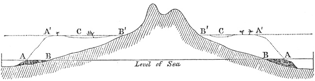
[No. 4]
A A—Outer edge of the reef at the level
of the sea.
B B—Shores of the island.
A'A'—Outer edge of the reef, after its
upward growth during a period of subsidence.
C C—The lagoon-channel between the reef
and the shores of the now encircled land.
B'B'—The shores of the encircled
island.
N.B. In this, and the following wood-cut, the subsidence of the land could only be represented by an apparent rise in the level of the sea.
(No. 4.) represent a vertical section through such an island; and the horizontal shading will represent the section of the reef. Now, as the island sinks down, either a few feet at a time or quite insensibly, we may safely infer from what we know of the conditions favourable to the growth of coral, that the living masses bathed by the surf on the margin of the reef, will soon regain the surface. The water, however, will encroach, little by little, on the shore, the island becoming lower and smaller, and the space between the edge of the reef and the beach proportionally broader. A section of the reef and island in this state, after a subsidence of several hundred feet, is given by the dotted lines: coral-islets are supposed to have been formed on the new reef, and a ship is anchored in the lagoon-channel. This section is in every respect that of an encircling barrier-reef; it is, in fact, a section taken* E. and W. through the highest point of the encircled island of Bolabola; of which a plan is given in Plate I. fig. 5. The same section is more clearly shown in the following woodcut (No. 5) by the unbroken lines. The width of the reef, and its slope both on the outer and inner side, will have been determined by the growing powers of the coral, under the conditions, (for instance the force of the breakers and of the currents) to which it has been exposed; and the lagoon-channel will be deeper or shallower, in proportion to the growth of the delicately branched corals within the reef, and to the accumulation of sediment, relatively, also, to the rate of subsidence and the length of the intervening stationary periods.
It is evident in this section, that a line drawn perpendicularly down from the outer edge of the new reef to the foundation of solid rock, exceeds by as many feet as there have been feet of subsidence, that small limit of depth at which the effective polypifers can live,—the corals having grown up, as
* The section has been made from the chart given in the Atlas of the Voyage of the Coquille. The scale is .57 of an inch to a mile. The height of the island, according to M. Lesson, is 4026 feet. The deepest part of the lagoon-channel is 162 feet; its depth is exaggerated in the woodcut for the sake of clearness.
H 2
the whole sank down, from a basis formed of other corals and their consolidated fragments. Thus the difficulty on this head, which before seemed so great, disappears.
As the space between the reef and the subsiding shore continued to increase in breadth and depth, and as the injurious effects of the sediment and fresh water borne down from the land were consequently lessened, the greater number of the channels, with which the reef in its fringing state must have been breached, especially those which fronted the smaller streams, will have become choked up by the growth of coral: on the windward side of the reef, where the coral grows most vigorously, the breaches will probably have first been closed. In barrier-reefs, therefore, the breaches kept open by draining the tidal waters of the lagoon-channel, will generally be placed on the leeward side, and they will still face the mouths of the larger streams, although removed beyond the influence of their sediment and fresh-water;—and this, it has been shown, is commonly the case.
Referring to the following diagram, in which the newly-formed barrier-reef is represented by unbroken lines, instead of by dots as in the former woodcut, let the work of subsidence go on, and the doubly-pointed hill will form two small

[No. 5.]
A'A'—Outer edges of the barrier-reef
at the level of the sea. The cocoa-nut trees represent coral-islets
formed on the reef.
CC—The lagoon-channel.
B'B'—The shores of the island, generally formed of
low alluvial land and of coral detritus from the lagoon-channel.
A"A"—The outer edges of the reef now forming an
atoll.
C'—The lagoon of the newly-formed atoll. According to the
scale, the depth of the lagoon and of the lagoon-channel is exaggerated.
islands (or more, according to the number of the hills) included within one annular reef. Let the island continue subsiding, and the coral-reef will continue growing up on its own foundation, whilst the water gains inch by inch on the land, until the last and highest pinnacle is covered, and there remains a perfect atoll. A vertical section of this atoll is shown in the woodcut by the dotted lines;—a ship is anchored in its lagoon, but islets are not supposed yet to have been formed on the reef. The depth of the lagoon and the width and slope of the reef, will depend on the circumstances just referred to under barrier-reefs. Any further subsidence will produce no change in the atoll, except perhaps a diminution in its size, from the reef not growing vertically upwards; but should the currents of the sea act violently on it, and should the corals perish on part or on the whole of its margin, changes would result during subsidence which will be presently noticed. I may here observe, that a bank either of rock or of hardened sediment, level with the surface of the sea, and fringed with living coral, would (if not so small as to allow the central space to be quickly filled up with detritus) by subsidence be converted immediately into an atoll, without passing, as in the case of a reef fringing the shore of an island, through the intermediate form of a barrier-reef. If such a bank lay a few fathoms submerged, the simple growth of the coral (as remarked in the third chapter) without the aid of subsidence, would produce a structure scarcely to be distinguished from a true atoll; for in all cases the corals on the outer margin of a reef, from having space and being freely exposed to the open sea, will grow vigorously and tend to form a continuous ring, whilst the growth of the less massive kinds on the central expanse, will be checked by the sediment formed there, and by that washed inwards by the breakers; and as the space becomes shallower, their growth will, also, be checked by the impurities of the water, and probably by the small amount of food brought by the enfeebled currents, in proportion to the surface of living reefs studded with innumerable craving mouths: the subsi-
dence of a reef based on a bank of this kind, would give depth to its central expanse or lagoon, steepness to its flanks, and through the free growth of the coral, symmetry to its outline:—I may here repeat that the larger groups of atolls in the Pacific and Indian oceans cannot be supposed to be founded on banks of this nature.
If, instead of the island in the diagram, the shore of a continent fringed by a reef had subsided, a great barrier-reef, like that on the N.E. coast of Australia, would have necessarily resulted; and it would have been separated from the main land by a deep-water channel, broad in proportion to the amount of subsidence, and to the less or greater inclination of the neighbouring coast-land. The effect of the continued subsidence of a great barrier-reef of this kind, and its probable conversion into a chain of separate atolls, will be noticed, when we discuss the apparent progressive disseverment of the larger Maldiva atolls.
We now are able to perceive that the close similarity in form, dimensions, structure, and relative position (which latter point will hereafter be more fully noticed) between fringing and encircling barrier-reefs, and between these latter and atolls, is the necessary result of the transformation, during subsidence, of the one class into the other. On this view, the three classes of reefs ought to graduate into each other. Reefs having an intermediate character between those of the fringing and barrier classes do exist; for instance, on the S.W. coast of Madagascar, a reef extends for several miles, within which there is a broad channel from seven to eight fathoms deep, but the sea does not deepen abruptly outside the reef. Such cases, however, are open to some doubts, for an old fringing reef, which had extended itself a little on a basis of its own formation, would hardly be distinguishable from a barrier-reef, produced by a small amount of subsidence, and with its lagoon-channel nearly filled up with sediment during a long stationary period. Between barrier-reefs, encircling either one lofty island or several small low ones, and atolls including a mere expanse of water, a striking series
can be shown: in proof of this, I need only refer to the first plate at the end of this volume, which speaks more plainly to the eye, than any description could to the ear. The authorities from which the charts have been engraved, together with some remarks on them, are given on a separate page descriptive of the plates. At New Caledonia (Plate II. fig. 5.) the barrier-reefs extend for 150 miles on each side of the submarine prolongation of the island; and at their northern extremity they appear broken up and converted into a vast atoll-formed reef, supporting a few low coral-islets: we may imagine that we here see the effects of subsidence actually in progress,—the water always encroaching on the northern end of the island, towards which the mountains slope down, and the reefs steadily building up their massive fabrics in the lines of their ancient growth.
We have as yet only considered the origin of barrier-reefs and atolls in their simplest form; but there remain some peculiarities in structure and some special cases, described in the two first chapters, to be accounted for by our theory. These consist,—in the inclined ledge terminated by a wall, and sometimes succeeded by a second ledge with a wall, round the shores of certain lagoons and lagoon-channels; a structure which cannot, as I endeavoured to show, be explained by the simple growing powers of the corals,—in the ring or bason-like form of the central reefs, as well as of the separate marginal portions of the northern Maldiva atolls,—in the submerged condition of the whole, or of parts of certain barrier and atoll-formed reefs; where only a part is submerged, this being generally to leeward,—in the apparent progressive disseverment of some of the Maldiva atolls,—in the existence of irregularly formed atolls, some being tied together by linear reefs, and others with spurs projecting from them,—and, lastly, in the structure and origin of the Great Chagos bank.
Step-formed ledges round certain lagoons.—If we suppose an atoll to subside at an extremely slow rate, it is difficult to follow out the complex results. The living corals would grow up on the outer margin; and likewise probably in the gullies
and deeper parts of the bare surface of the annular reef; the water would encroach on the islets, but the accumulation of fresh detritus might possibly prevent their entire submergence. After a subsidence of this very slow nature, the surface of the annular reef sloping gently into the lagoon, would probably become united with the irregular reefs and banks of sand, which line the shores of most lagoons. Should, however, the atoll be carried down by a more rapid movement, the whole surface of the annular reef, where there was a foundation of solid matter, would be favourably circumstanced for the fresh growth of coral; but as the corals grew upwards on its exterior margin, and the waves broke heavily on this part, the increase of the massive polypifers on the inner side would be checked from the want of water. Consequently, the exterior parts would first reach the surface, and the new annular reef thus formed on the old one, would have its summit inclined inwards, and be terminated by a subaqueous wall, formed by the upward growth of the coral (before being much checked), from the inner edge of the solid parts of the old reef. The inner portion of the new reef, from not having grown to the surface, would be covered by the waters of the lagoon. Should a subsidence of the same kind be repeated, the corals would again grow up in a wall, from all the solid parts of the resunken reef, and, therefore, not from within the sandy shores of the lagoon; and the inner part of the new annular reef would, from being as before checked in its upward growth, be of less height than the exterior parts, and therefore would not reach the surface of the lagoon. In this case the shores of the lagoon would be surrounded by two inclined ledges, one beneath the other, and both abruptly terminated by subaqueous cliffs.*
* According to Mr. Couthouy (p. 26) the external reef round many atolls descends by a succession of ledges or terraces. He attempts, I doubt whether successfully, to explain this structure somewhat in the same manner as I have attempted, with respect to the internal ledges round the lagoons of some atolls. More facts are wanted regarding the nature both of the interior and exterior step-like ledges: are all the ledges, or only the upper ones, covered with living coral? if they
The ring or bason-formed reefs of the northern Maldiva atolls.—I may first observe, that the reefs within the lagoons of atolls and within lagoon-channels, would, if favourably circumstanced, grow upwards during subsidence in the same manner as the annular rim; and, therefore, we might expect that such lagoon-reefs, when not surrounded and buried by an accumulation of sediment more rapid than the rate of subsidence, would rise abruptly from a greater depth than that at which the efficient polypifers can flourish: we see this well exemplified in the small abruptly-sided reefs, with which the deep lagoons of the Chagos and Southern Maldiva atolls are studded. With respect to the ring or bason-formed reefs of the Northern Maldiva atolls, it is evident, from the perfectly continuous series which exists, that the marginal rings, although wider than the exterior or bounding reef of ordinary atolls, are only modified portions of such a reef; it is also evident that the central rings, although wider than the knolls or reefs which commonly occur in lagoons, occupy their place. The ring-like structure has been shown to be contingent on the breaches into the lagoon being broad and numerous, so that all the reefs which are bathed by the waters of the lagoon, are placed under nearly the same conditions with the outer coast of an atoll standing in the open sea. Hence the exterior and living margins of these reefs must have been favourably circumstanced for growing outwards, and increasing beyond the usual breadth; and they must likewise have been favourably circumstanced for growing vigorously upwards, during the subsiding movements, to which by our theory the whole archipelago has been subjected; and subsidence with this upward growth of the margins would convert the central space of each little reef into a small lagoon. This, however, could only take place with those reefs, which had increased to a breadth sufficient to prevent their central spaces from being almost immediately filled up with the sand and detritus
are all covered, are the kinds different on the ledges according to the depth? Do the interior and exterior ledges occur together in the same atolls; if so, what is their total width, and is the intervening surface-reef narrow, &c.?
driven inwards from all sides: hence it is that few reefs, which are less than half a mile in diameter, even in the atolls where the bason-like structure is most strikingly exhibited, include lagoons. This remark, I may add, applies to all coral-reefs, wherever found. The bason-formed reefs of the Maldiva Archipelago may, in fact, be briefly described, as small atolls formed during subsidence over the separate portions of large and broken atolls, in the same manner as these latter were formed over the barrier-reefs, which encircled the islands of a large archipelago now wholly submerged.
Submerged and Dead Reefs.—In the second section of the first chapter, I have shown that there are in the neighbourhood of atolls, some deeply submerged banks, with level surfaces; that there are others, less deeply but yet wholly submerged, having all the characters of perfect atolls, but consisting merely of dead coral-rock; that there are barrier-reefs and atolls with merely a portion of their reef, generally on the leeward side, submerged; and that such portions either retain their perfect outline, or they appear to be quite effaced, their former place being marked only by a bank, conforming in outline with that part of the reef which remains perfect. These several cases are, I believe, intimately related together, and can be explained by the same means. There, perhaps, exist some submerged reefs, covered with living coral and growing upwards, but to these I do not here refer.
As we see that in those parts of the ocean, where coral reefs are most abundant, one island is fringed and another neighbouring one is not fringed; as we see in the same archipelago, that all the reefs are more perfect in one part of it than in another,—for instance, in the southern half compared with the northern half of the Maldiva Archipelago, and likewise on the outer coasts compared with the inner coasts of the atolls in this same group, which are placed in a double row; as we know that the existence of the innumerable polypifers forming a reef, depends on their sustenance, and that they are preyed on by other organic beings; and, lastly, as we know that some inorganic causes are highly injurious to the growth of coral, it cannot be expected that during the round
of change to which earth, air, and water are exposed, the reef-building polypifers should keep alive for perpetuity in any one place; and still less can this be expected, during the progressive subsidences, perhaps at some periods more rapid than at others, to which by our theory these reefs and islands have been subjected and are liable. It is, then, not improbable that the corals should sometimes perish either on the whole or on part of a reef; if on part, the dead portion, after a small amount of subsidence, would still retain its proper outline and position beneath the water. After a more prolonged subsidence, it would probably form, owing to the accumulation of sediment, only the margin of a flat bank, marking the limits of the former lagoon. Such dead portions of reef would generally lie on the leeward side,* for the impure water and fine sediment would more easily flow out from the lagoon over this side of the reef, where the force of the breakers is less than to windward; and therefore the corals would be less vigorous on this side, and be less able to resist any destroying agent. It is likewise owing to this same cause, that reefs are more frequently breached to leeward by narrow channels, serving as by ship-channels, than to windward. If the corals perished entirely, or on the greater part of the circumference of an atoll, an atoll-shaped bank of dead rock, more or less entirely submerged, would be produced; and further subsidence, together with the accumulation of sediment, would often obliterate
* Mr. Lyell, in the first edition of his Principles of Geology, offered a somewhat different explanation of this structure. He supposes that there has been subsidence; but he was not aware that the submerged portions of reef were in most cases, if not in all, dead; and he attributes the difference in height in the two sides of most atolls, chiefly to the greater accumulation of detritus to windward than to leeward. But as matter is accumulated only on the backward part of the reef, the front part would remain of the same height on both sides. I may here observe that in most cases (for instance at Peros Banhos, the Gambier group and the Great Chagos bank) and I suspect in all cases, the dead and submerged portions do not blend or slope into the living and perfect parts, but are separated from them by an abrupt line. In some instances small patches of living reef rise to the surface from the middle of the submerged and dead parts.
its atoll-like structure, and leave only a bank with a level surface.
In the Chagos group of atolls, within an area of 160 miles by 60, there are two atoll-formed banks of dead rock (besides another very imperfect one) entirely submerged; a third, with merely two or three very small pieces of living reef rising to the surface; and a fourth, namely Peros Banhos (Plate I. fig. 9), with a portion nine miles in length dead and submerged. As by our theory this area has subsided, and as there is nothing improbable in the death, either from changes in the state of the surrounding sea or from the subsidence being great or sudden, of the corals on the whole, or on portions of some of the atolls, the case of the Chagos group presents no difficulty. So far indeed are any of the above-mentioned cases of submerged reefs from being inexplicable, that their occurrence might have been anticipated on our theory; and as fresh atolls are supposed to be in progressive formation by the subsidence of encircling barrier-reefs, a weighty objection, namely that the number of atolls must be increasing infinitely, might even have been raised, if proofs of the occasional destruction and loss of atolls could not have been adduced.
The disseverment of the larger Maldiva atolls.—The apparent progressive disseverment in the Maldiva Archipelago of large atolls into smaller ones, is, in many respects, an important consideration, and requires an explanation. The graduated series, which marks as I believe this process, can be observed only in the northern half of the group, where the atolls have exceedingly imperfect margins, consisting of detached bason-formed reefs. The currents of the sea flow across these atolls, as I am informed by Capt. Moresby, with considerable force, and drift the sediment from side to side during the monsoons, transporting much of it seaward; yet the currents sweep with greater force round their flanks. It is historically known that these atolls have long existed in their present state; and we can believe, that even during a very slow subsidence they might
I
thus remain, the central expanse being kept at nearly its original depth by the accumulation of sediment. But in the action of such nicely balanced forces during a progressive subsidence, (like that, to which by our theory this archipelago has been subjected,) it would be strange if the currents of the sea should never make a direct passage across some one of the atolls, through the many wide breaches in their margins. If this were once effected, a deep-water channel would soon be formed by the removal of the finer sediment, and the check to its further accumulation; and the sides of the channel would be worn into a slope like that on the outer coasts, which are exposed to the same force of the currents. In fact, a channel precisely like that bifurcating one which divides Mahlos Mahdoo (Plate II. fig. 4.), would almost necessarily be formed. The scattered reefs situated near the borders of the new ocean-channel, from being favourably placed for the growth of coral, would, by their extension, tend to produce fresh margins to the dissevered portions: such a tendency is very evident, (as may be seen in the large published chart) in the elongated reefs on the borders of the two channels intersecting Mahlos Mahdoo. Such channels would become deeper with continued subsidence, and probably from the reefs not growing up perpendicularly, somewhat broader. In this case, and more especially if the channels had been formed originally of considerable breadth, the dissevered portions would become perfect and distinct atolls, like Ari and Ross atolls, (Plate II, fig. 6.) or like the two Nillandoo atolls, which must be considered as distinct, although related in form and position, and separated from each other by channels, which though deep have been sounded. Further subsidence would render such channels unfathomable, and the dissevered portions would then resemble Phaleedoo and Moluque atolls, or Mahlos Mahdoo and Horsburgh atolls, (Plate II. fig. 4.) which are related to each other in no respect except in proximity and position. Hence, on the theory of subsidence, the disseverment of large atolls, which have imperfect margins (for otherwise their disseverement would be
scarcely possible), and which are exposed to strong currents, is far from being an improbable event; and the several stages from close relation to entire isolation in the atolls of the Maldiva Archipelago, are readily explicable.
We might go even further, and assert as not improbable, that the first formation of the Maldiva Archipelago was due to a barrier-reef, of nearly the same dimensions with that of New Caledonia (Plate II. fig. 5.): for if, in imagination, we complete the subsidence of that great island, we might anticipate from the present broken condition of the northern portion of the reef, and from the almost entire absence of reefs on the eastern coast, that the barrier-reef after repeated subsidences, would become during its upward growth separated into distinct portions; and these portions would tend to assume an atoll-like structure, from the coral growing with vigour round their entire circumferences, when freely exposed to an open sea. As we have some large islands partly submerged with barrier-reefs marking their former limits, such as New Caledonia, so our theory makes it probable that there should be other large islands wholly submerged; and these, we may now infer, would be surmounted, not by one enormous atoll, but by several large elongated ones, like the atolls in the Maldiva group; and these again, during long periods of subsidence, would sometimes become dissevered into smaller atolls. I may add, that both in the Marshall and Caroline Archipelagoes, there are atolls standing close together, which have an evident relationship in form: we may suppose, in such cases, either that two or more encircled islands originally stood close together, and afforded bases for two or more atolls, or that one atoll has been dissevered. From the position, as well as form, of three atolls in the Caroline Archipelago (the Namourrek and Elato group), which are placed in an irregular circle, I am strongly tempted to believe that they have originated by the process of disseverment.*
* The same remark is, perhaps, applicable to the islands of Ollap, Fanadik, and Tamatam in the Caroline Archipelago, of which charts
Irregularly-formed Atolls.—In the Marshall group, Musquillo atoll consists of two loops united in one point; and Menchicoff atoll is formed of three loops, two of which (as may be seen in fig. 3. Plate II.) are connected by a mere ribbon-shaped reef, and the three together are 60 miles in length. In the Gilbert group some of the atolls have narrow strips of reef, like spurs, projecting from them. There occur also in parts of the open sea, a few linear and straight reefs, standing by themselves; and likewise some few reefs in the form of crescents, with their extremities more or less curled inwards. Now, the upward growth of a barrier-reef which fronted only one side of an island, or one side of an elongated island with its extremities, (of which cases exist,) would produce after the complete subsidence of the land, mere strips or crescent or hook-formed reefs: if the island thus partially fronted became divided during subsidence into two or more islands, these islands would be united together by linear reefs; and from the further growth of the coral along their shores together with subsidence, reefs of various forms might ultimately be produced, either atolls united together by linear reefs, or atolls with spurs projecting from them. Some, however, of the more simple forms above specified, might, as we have seen, be equally well produced by the coral perishing during subsidence on part of the circumference of an atoll, whilst on the other parts it continued to grow up till it reached the surface.
The Great Chagos Bank.—I have already shown that the submerged condition of the Great Chagos bank, (Plate II. fig. 1. with its section fig. 2.) and of some other banks in the Chagos group, may in all probability be attributed to the coral having perished before or during the movements of subsidence, to which this whole area by our theory has been sub-
are given in the atlas of Duperrey's voyage: a line drawn through the linear reefs and lagoons of these three islands forms a semicircle. Consult also, the atlas of Lutké's voyage; and for the Marshall group that of Kotzebue; for the Gilbert group (which is referred to in the ensuing page) consult the atlas of Duperrey's voyage. Most of the points here referred to may, however, be seen in Krusenstern's general Atlas of the Pacific.
jected. The external rim or upper ledge, (shaded in the chart,) consists of dead coral-rock thinly covered with sand; it lies at an average depth of between five and eight fathoms, and perfectly resembles in form the annular reef of an atoll. The banks of the second level, the boundaries of which are marked by dotted lines in the chart, lie from about fifteen to twenty fathoms beneath the surface; they are several miles broad, and terminate in a very steep slope round the central expanse. This central expanse I have already described, as consisting of a level muddy flat between thirty and forty fathoms deep. The banks of the second level, might at first sight be thought analogous to the internal step-like ledge of coral-rock which borders the lagoons of some atolls, but their much greater width, and their being formed of sand, are points of essential difference. On the eastern side of the atoll some of the banks are linear and parallel, resembling islets in a great river, and pointed directly towards a great breach on the opposite side of the atoll: these are best seen in the large published chart. I inferred from this circumstance, that strong currents sometimes set directly across this vast bank; and I have since heard from Capt. Moresby that this is the case. I observed, also, that the channels, or breaches through the rim, were all of the same depth as the central lagoon-like space into which they lead; whereas the channels into the other atolls of the Chagos group, and as I believe into most other large atolls, are not nearly as deep as their lagoons:—for instance at Peros Banhos, the channels are only of the same depth, namely between 10 and 20 fathoms, as the bottom of the lagoon for a space about a mile and a half in width round its shores, whilst the central expanse of the lagoon is from 35 to 40 fathoms deep. Now, if an atoll during a gradual subsidence once became entirely submerged, like the Great Chagos bank, and therefore no longer exposed to the surf, very little sediment could be formed from it; and consequently the channels leading into the lagoon from not being filled up with drifted sand and coral detritus, would continue increasing in depth, as the whole sank down. In this case, we might
expect that the currents of the open sea, instead of any longer sweeping round the submarine flanks, would flow directly through the breaches across the lagoon, removing in their course the finer sediment, and preventing its further accumulation. We should then have the submerged reef forming an external and upper rim of rock, and beneath this portions of the sandy bottom of the old lagoon, intersected by deep-water channels or breaches, and thus formed into separate marginal banks; and these would be cut off by steep slopes, overhanging the central space, worn down by the passage of the oceanic currents.
By these means, I have scarcely any doubt that the Great Chagos bank has originated,—a structure which at first appeared to me far more anomalous than any I had met with. The process of formation is nearly the same with that, by which Mahlos Mahdoo has been trisected; but in the Chagos bank the channels of the oceanic currents entering at several different quarters, have united in a central space.
This great atoll-formed bank appears to be in an early stage of disseverment; should the work of subsidence go on, from the submerged and dead condition of the whole reef, and the imperfection of the S.E. quarter, a mere wreck would probably be left. The Pitt's bank, situated not far southward, appears to be precisely in this state: it consists of a moderately level, oblong bank of sand, lying from 10 to 20 fathoms beneath the surface, with two sides protected by a narrow ledge of rock which is submerged between 5 and 8 fathoms. A little further south, at about the same distance as the southern rim of the Great Chagos bank is from the northern rim, there are two other small banks with from 10 to 20 fathoms on them; and not far eastward soundings were struck on a sandy bottom, with between 110 and 145 fathoms. The northern portion with its ledge-like margin, closely resembles any one segment of the Great Chagos bank, between two of the deep-water channels, and the scattered banks southward appear to be the last wrecks of less perfect portions.
I
I have examined with care the charts of the Indian and Pacific oceans, and have now brought before the reader all the examples, which I have met with, of reefs differing from the type of the class to which they belong; and I think it has been satisfactorily shown, that they are all included in our theory, modified by occasional accidents which might have been anticipated as probable. In this course we have seen, that in the lapse of ages encircling barrier-reefs are occasionally converted into atolls,—the name of atoll being properly applicable, at the moment when the last pinnacle of encircled land sinks beneath the surface of the sea. We have, also, seen that large atolls during the progressive subsidence of the areas, in which they stand, sometimes become dissevered into smaller ones; at other times, the reef-building polypifers having entirely perished, atolls are converted into atoll-formed banks of dead rock; and these again, through further subsidence and the accumulation of sediment, modified by the force of the oceanic currents, pass into level banks with scarcely any distinguishing character. Thus may the history of an atoll be followed from its first origin, through the occasional accidents of its existence, to its destruction and final obliteration.
Objections to the theory of the formation of Atolls and Barrier-reefs.—The vast amount of subsidence, both horizontally or in area, and vertically or in depth, necessary to have submerged every mountain, even the highest, throughout the immense spaces of ocean interspersed with atolls, will probably strike most people as a formidable objection to my theory. But as continents, as large as the spaces supposed to have subsided, have been raised above the level of the sea,—as whole regions are now rising, for instance, in Scandinavia and South America,—and as no reason can be assigned, why subsidences should not have occurred in some parts of the earth's crust on as great a scale both in extent and amount as those of elevation, objections of this nature strike me as of little force. The remarkable point is, that movements to such an extent should have taken place
within a period, during which the polypifers have continued adding matter on and above the same reefs. Another and less obvious objection to the theory will perhaps be advanced from the circumstance, of the lagoons within atolls and within barrier-reefs never having become in any one instance during prolonged subsidences of a greater depth than 60 fathoms, and seldom more than 40 fathoms: but we already admit, if the theory be worth considering, that the rate of subsidence has not exceeded that of the upward growth of the corals on the exterior margin; we are, therefore, only further required to admit, that the subsidence has not exceeded in rate the filling up of the interior spaces by the growth of the corals living there, and by the accumulation of sediment. As this filling up must take place very slowly within barrier-reefs lying far from the land, and within atolls which are of large dimensions and which have open lagoons with very few reefs, we are led to conclude that the subsidence thus counter-balanced, must have been slow in an extraordinary degree;—a conclusion which accords with our only means, namely, with what is known of the rate and manner of recent elevatory movements, of judging by analogy what is the probable rate of subsidence.
In this chapter it has, I think, been shown, that the theory of subsidence, which we were compelled to receive from the necessity of giving to the corals, in certain large areas, foundations at the requisite depth, explains both the normal structure and the less regular forms of those two great classes of reefs, which have justly excited the astonishment of all persons who have sailed through the Pacific and Indian oceans. But further to test the truth of the theory, a crowd of questions will occur to the reader: Do the different kinds of reefs, which have been produced by the same kind of movement, generally lie within the same areas? What is their relation of form and position,—for instance, do adjoining groups of atolls, and the separate atolls in these groups, bear the same relation to each other which islands do in common archipelagoes? Have we reason to believe, that where there are fringing
I 2
reefs, there has not lately been subsidence; or, for it is almost our only way of ascertaining this point, are there frequently proofs of recent elevation? Can we by this means account for the presence of certain classes of reefs in some large areas, and their entire absence in others? Do the areas which have subsided, as indicated by the presence of atolls and barrier-reefs, and the areas which have remained stationary or have been upraised, as shown by fringing-reefs, bear any determinate relation to each other; and are the dimensions of these areas such as harmonize with the greatness of the subterranean changes, which, it must be supposed, have lately taken place beneath them? Is there any connection between the movements thus indicated, and recent volcanic action?—All these questions ought to receive answers in accordance with the theory; and if this can be satisfactorily shown, not only is the theory confirmed, but as deductions, the answers are in themselves important. Under this latter point of view, these questions will be chiefly considered in the following chapter.*
* I may take this opportunity of briefly considering the appearances, which would probably be presented by a vertical and deep section across a coral formation (referring chiefly to an atoll) formed by the upward growth of coral during successive subsidences. This is a subject worthy of attention, as a means of comparison with ancient coral strata. The circumferential parts would consist of massive species, in a vertical position, with their interstices filled up with detritus; but this would be the part most subject to subsequent denudation and removal. It is useless to speculate how large a proportion of the exterior annular reef would consist of upright coral, and how much of fragmentary rock, for this would depend on many contingencies,—such as on the rate of subsidence, occasionally allowing a fresh growth of coral to cover the whole surface, and on the breakers having force sufficient to throw fragments over this same space. The conglomerate which composes the base of the islets, would (if not removed by denudation together with the exterior reef on which it rests) be conspicuous from the size of the fragments,—the different degrees in which they have been rounded,—the presence of fragments of conglomerate torn up rounded and recemented,—and from the oblique stratification. The corals which lived in the lagoon-reefs at each successive level, would be preserved upright, and they would consist of many kinds, generally much branched. In this part, however, a very large proportion of
2
the rock (and in some cases nearly all of it) would be formed of sedimentary matter, either in an excessively fine, or in a moderately coarse state, and with the particles almost blended together. The conglomerate which was formed of rounded pieces of the branched corals, on the shores of the lagoon, would differ from that formed on the islets and derived from the outer coast; yet both might have accumulated very near each other. I have seen a conglomerate limestone from Devonshire like a conglomerate now forming on the shores of the Maldiva atolls. The stratification taken as a whole, would be horizontal; but the conglomerate beds resting on the exterior reef, and the beds of sandstone on the shores of the lagoon (and no doubt on the external flanks) would probably be divided (as at Keeling atoll and at Mauritius) by numerous layers dipping at considerable angles in different directions. The calcareous sandstone and coral rock would almost necessarily contain innumerable shells, echini, and the bones of fish, turtle, and perhaps of birds; possibly, also, the bones of small saurians, as these animals find their way to the islands far remote from any continent. The large shells of some species of Tridacna would be found vertically imbedded in the solid rock, in the position in which they lived. We might expect, also, to find a mixture of the remains of pelagic and littoral animals in the strata formed in the lagoon, for pumice and the seeds of plants are floated from distant countries into the lagoons of many atolls: on the outer coast of Keeling atoll, near the mouth of the lagoon, the case of a pelagic Pteropodous animal was brought up on the arming of the sounding lead. All the loose blocks of coral on Keeling atoll were burrowed by vermiform animals; and as every cavity, no doubt, ultimately becomes filled with spathose limestone, slabs of the rock taken from a considerable depth, would, if polished, probably exhibit the excavations of such burrowing animals. The conglomerate and fine-grained beds of coral-rock would be hard, sonorous, white, and composed of nearly pure calcareous matter: in some few parts, judging from the specimens at Keeling atoll, they would probably contain a small quantity of iron. Floating pumice and scoriæ, and occasionally stones transported in the roots of trees (see my Journal of Researches, p. 549) appear the only sources, through which foreign matter is brought to coral-formations standing in the open ocean. The area over which sediment is transported from coral-reefs must be considerable: Capt. Moresby informs me that during the change of monsoons, the sea is discoloured to a considerable distance off the Maldiva and Chagos atolls. The sediment off fringing and barrier coral-reefs must be mingled with the mud, which is brought down from the land, and is transported seaward through the breaches, which occur in front of almost every valley. If the atolls of the larger archipelagoes were upraised, the bed of the ocean being converted into
land, they would form flat-topped mountains, varying in diameter from a few miles (the smallest atolls being worn away) to sixty miles; and from being horizontally stratified and of similar composition, they would, as Mr. Lyell has remarked, falsely appear as if they had originally been united into one vast continuous mass. Such great strata of coral-rock would rarely be associated with erupted volcanic matter, for this could only take place, as may be inferred from what follows in the next chapter, when the area, in which they were situated, commenced to rise, or at least ceased to subside. During the enormous period necessary to effect an elevation of the kind just alluded to, the surface would necessarily be denuded to a great thickness; hence it is highly improbable that any fringing-reef, or even any barrier-reef, at least of those encircling small islands, would be preserved. From this same cause, the strata which were formed within the lagoons of atolls and lagoon-channels of barrier-reefs, and which must consist in a large part of sedimentary matter, would more often be preserved to future ages, than the exterior solid reef, composed of massive corals in an upright position; although it is on this exterior part, that the present existence and further growth of atolls and barrier-reefs entirely depend.
CHAPTER VI.
ON THE DISTRIBUTION OF CORAL REEFS WITH REFERENCE TO THE THEORY OF THEIR FORMATION.
Description of the coloured map—Proximity of atolls and barrier-reefs—Relation in form and position of atolls with ordinary islands—Direct evidence of subsidence difficult to be detected—Proofs of recent elevation where fringing reefs occur—Oscillations of level—Absence of active volcanos in the areas of subsidence—Immensity of the areas which have been elevated and have subsided—Their relation to the present distribution of the land—Areas of subsidence elongated, their intersection and alternation with those of elevation—Amount, and slow rate of the subsidence—Recapitulation.
IT will be convenient to give here a short account of the appended map (Plate III.); a fuller one, with the data for colouring each spot, is reserved for the Appendix; and every place there referred to may be found in the Index. A larger chart would have been desirable; but, small as the adjoined one is, it is the result of many months' labour. I have consulted, as far as I was able, every original voyage and map; and the colours were first laid down on charts on a larger scale. The same blue colour, with merely a difference in the depth of tint, is used for atolls or lagoon-islands, and barrier-reefs; for we have seen, that as far as the actual coral-formation is concerned, they have no distinguishing character. Fringing-reefs have been coloured red, for between them on the one hand, and barrier-reefs and atolls on the other, there is an important distinction with respect to the depth beneath the surface, at which we are compelled to believe their foundations lie. The two distinct colours, therefore, mark two great types of structure.
The dark blue colour represents atolls and submerged
annular reefs, with deep water in their centres. I have coloured as
atolls, a few low and small coral-islands, without lagoons; but this
has been done only when it clearly appeared that they originally
contained lagoons, since filled up with sediment: when there were not
good grounds for this belief, they have been left uncoloured.
The pale blue colour represents barrier-reefs. The most obvious character of reefs of this class is the broad and deep-water moat within the reef; but this, like the lagoons of small atolls, is liable to become filled up with detritus and with reefs of delicately-branched corals: when, therefore, a reef round the entire circumference of an island extends very far into a profoundly deep sea, so that it can hardly be confounded with a fringing-reef which must rest on a foundation of rock within a small depth, it has been coloured pale blue, although it does not include a deep-water moat: but this has only been done rarely, and each case is distinctly mentioned in the Appendix.
The red colour represents reefs, fringing the land quite closely where the sea is deep, and where the bottom is gently inclined extending to a moderate distance from it, but not having a deep-water moat or lagoon like space parallel to the shore. It must be remembered that fringing reefs are frequently breached in front of rivers and valleys by deepish channels, where mud has been deposited. A space of 30 miles in width has been coloured round or in front of the reefs of each class, in order that the colours might be conspicuous on the appended map, which is reduced to so small a scale.
The vermilion spots, and streaks, represent volcanos now in action, or historically known to have been so. They are chiefly laid down from Von Buch's work on the Canary Islands; and my reasons for making a few alterations are given in the note below.*
* I have also made considerable use of the geological part of Berghaus' Physical Atlas. Beginning at the eastern side of the Pacific, I have added to the number of the volcanos in the southern part of the Cordillera, and have coloured Juan Fernandez according to observations collected during the voyage of the Beagle, (Geol. Trans. vol. v. p. 601.)
The uncoloured coasts consist, first and chiefly, of those, where there are no coral-reefs, or such small portions as to be quite insignificant. Secondly, of those coasts where there are
I have added a volcano to Albemarle Island, one of the Galapagos Archipelago, (the author's Journal of Researches, p. 457). In the Sandwich group there are no active volcanos, except at Hawaii; but the Rev. W. Ellis informs me, there are streams of lava apparently modern on Maui, having a very recent appearance, which can be traced to the craters whence they flowed. The same gentleman informs me, that there is no reason to believe that any active volcano exists in the Society Archipelago; nor are there any known in the Samoa or Navigator group, although some of the streams of lava and craters there appear recent. In the Friendly group, the Rev. J. Williams says (Narrative of Missionary Enterprise, p. 29) that Toofoa and Proby Islands are active volcanos. I infer from Hamilton's Voyage in the Pandora (p. 95), that Proby Island is synonymous with Onouafou, but I have not ventured to colour it. There can be no doubt respecting Toofoa; and Captain Edwards (Von Buch, p. 386) found the lava of a recent eruption at Amargura still smoking. Berghaus marks four active volcanos actually within the Friendly group; but I do not know on what authority: I may mention that Maurelle describes Latte as having a burnt-up appearance: I have marked only Toofoa and Amargura. South of the New Hebrides lies Matthews Rock, which is drawn and described as an active crater in the voyage of the Astrolabe. Between it and the volcano on the eastern side of New Zealand, lies Brimstone Island, which from the high temperature of the water in the crater, may be ranked as active. (Berghaus Vorbemerk. 11. Lief. S. 56). Malte Brun, vol. xii. p. 231, says that there is a volcano near port St. Vincent in New Caledonia. I believe this to be an error, arising from a smoke seen on the opposite coast by Cook (2nd voyage, vol. ii. p. 23) which smoke went out at night. The Mariana Islands, especially the northern ones, contain many craters (see Freycinet's Hydrog. Descript.) which are not active. Von Buch, however, states (p. 462) on the authority of La Peyrouse, that there are no less than seven volcanos between these islands and Japan. Gemellli Careri (Churchill's Collect. vol. iv. p. 458), says there are two active volcanos in lat. 23° 30' and in lat. 24°; but I have not coloured them. From the statements in Beechey's Voyage (p. 518, 4to edit.) I have coloured one in the northern part of the Bonin group. M. S. Julien has clearly made out from Chinese manuscripts not very ancient, (Comptes Rendus, 1840, p. 832), that there are two active volcanos on the eastern side of Formosa. In Torres Straits, on Cap Island (9° 48' S. 142° 39' E.) a volcano was seen burning with great violence in 1793 by Capt. Bampton (see Introduction to Flinders'
reefs, but where the sea is very shallow, for in this case the reefs generally lie far from the land, and become very irregular in their forms; where they have not become irregular, they have been coloured. Thirdly, if I had the means of ascertaining the fact, I should not colour a reef merely coating the edges of a submarine crater, or of a level submerged bank; for such superficial formations differ essentially, even when not in external appearance, from reefs whose foundations as well as superficies have been wholly formed by the growth of coral. Fourthly, in the Red Sea, and within some parts of the East Indian Archipelago, (if the imperfect charts of the latter can be trusted,) there are many scattered reefs, of small size, represented in the chart by mere dots, which rise out of deep water: these cannot be arranged under either of the three classes: in the Red Sea, however, some of these little reefs, from their position, seem once to have formed parts of a continuous barrier. There exist, also, scattered in the open ocean, some linear and irregularly-formed strips of coral-reef, which, as shown in the last chapter, are probably allied in their origin to atolls; but as they do not belong to that class, they have not been coloured; they are very few in number, and of insignificant dimensions. Lastly,
Voyage, p. 41). Mr. M'Clelland (Report of Committee for investigating Coal in India, p. 39) has shown that the volcanic band passing through Barren Island must be extended northwards. It appears by an old chart, that Cheduba was once an active volcano; (See also Silliman's North American Journal, vol. xxxviii. p. 385.) In Berghaus' Phys. Atlas, 1840, No. 7 of Geological Part, a volcano on the coast of Pondicherry is said to have burst forth in 1757. Ordinaire (Hist. Nat. des Volcans, p. 218) says that there is one at the mouth of the Persian Gulf, but I have not coloured it, as he gives no particulars. A volcano in Amsterdam, or St. Paul's, in the southern part of the Indian Ocean, has been seen (Naut. Mag. 1838, p. 842) in action. Dr. J. Allan, of Forres, informs me in a letter, that when he was at Joanna, he saw at night flames, apparently volcanic, issuing from the chief Comoro Island, and that the Arabs assured him that they were volcanic, adding that the volcano burned more during the wet season. I have marked this as a volcano, though with some hesitation, on account of the possibility of the flame arising from gaseous sources.
some reefs are left uncoloured from the want of information respecting them, and some because they are of an intermediate structure between the barrier and fringing classes. The value of the map is lessened, in proportion to the number of reefs which I have been obliged to leave uncoloured, although, in a theoretical point of view, few of them present any great difficulty: but their number is not very great, as will be found by comparing the map with the statements in the Appendix. I have experienced more difficulty in colouring fringing-reefs than in colouring barrier-reefs, as the former, from their much less dimensions, have less attracted the attention of navigators. As I have had to seek my information from all kind of sources, and often from indirect ones, I do not venture to hope that the map is free from many errors. Nevertheless, I trust it will give an approximately correct view of the general distribution of the coral-reefs over the whole world, (with the exception of some fringing-reefs on the coast of Brazil, not included within the limits of the map,) and of their arrangement into the three great classes, which, though necessarily very imperfect from the nature of the objects classified, have been adopted by most voyagers. I may further remark, that the dark blue colour represents land entirely composed of coral-rock; the pale blue, land with a wide and thick border of coral-rock; and the red, a mere narrow fringe of coral-rock.
Looking now at the map under the theoretical point of view indicated in the last chapter, the two blue tints signify that the foundations of the reefs thus coloured have subsided to a considerable amount, at a slower rate than that of the upward growth of the corals; and that probably in many cases they are still subsiding. The red signifies that the shores which support fringing-reefs have not subsided (at least to any considerable amount, for the effects of a subsidence on a small scale would in no case be distinguishable); but that they have remained nearly stationary since the period when they first became fringed by reefs; or that they are now rising or have been upraised, with new lines of reefs successively
formed on them: these latter alternatives are obviously implied, as newly-formed lines of shore, after elevations of the land, would be in the same state with respect to the growth of fringing-reefs, as stationary coasts. If during the prolonged subsidence of a shore, coral-reefs grew for the first time on it, or if an old barrier-reef were destroyed and submerged, and new reefs became attached to the land, these would necessarily at first belong to the fringing class, and, therefore, be coloured red, although the coast was sinking: but I have no reason to believe, that from this source of error, any coast has been coloured wrongly with respect to movement indicated. Well characterized atolls and encircling barrier-reefs, where several occur in a group, or a single barrier-reef if of large dimensions, leave scarcely any doubt on the mind respecting the movement by which they have been produced; and even a small amount of subsequent elevation is soon betrayed. The evidence from a single atoll, or a single encircling barrier-reef, must be received with some caution, for the former may possibly be based upon a submerged crater or bank, and the latter on a submerged margin of sediment, or of worn-down rock. From these remarks we may with greater certainty infer that the spaces, especially the larger ones, tinted blue in the map, have subsided, than that the red spaces have remained stationary, or have been upraised.
On the grouping of the different classes of reefs.—Having made these preliminary remarks, I will consider first how far the grouping of the different kinds of coral-islands and reefs is corroborative of the truth of the theory. A glance at the map shows that the reefs, coloured blue and red, produced under widely different conditions, are not indiscriminately mixed together. Atolls and barrier-reefs, on the other hand, as may be seen by the two blue tints, generally lie near each other; and this would be the natural result of both having been produced during the subsidence of the areas in which they stand. Thus, the largest group of encircled islands is that of the Society Archipelago; and these islands are surrounded by atolls, and only separated by a narrow space from the
large group of Low atolls. In the midst of the Caroline atolls, there are three fine encircled islands. The northern point of the barrier-reef of New Caledonia seems itself, as before remarked, to form a complete large atoll. The great Australian barrier is described as including both atolls and small encircled islands. Capt. King* mentions many atoll-formed and encircling coral-reefs, some of which lie within the barrier, and others may be said (for instance between lat. 16° and 13°) to form part of it. Flinders† has described an atoll-formed reef in lat. 10°, seven miles long and from one to three broad, resembling a boot in shape, with apparently very deep water within. Eight miles westward of this, and forming part of the barrier, lie the Murray Islands, which are high and are encircled. In the Corallian sea, between the two great barriers of Australia and New Caledonia, there are many low islets and coral-reefs, some of which are annular, or horse-shoe shaped. Observing the smallness of the scale of the map, the parallels of latitude being 900 miles apart, we see, that none of the large groups of reefs and islands supposed to have been produced by long-continued subsidence, lie near extensive lines of coast coloured red, which are supposed to have remained stationary since the growth of their reefs, or to have been upraised and new lines of reefs formed on them. Where the red and blue circles do occur near each other, I am able, in several instances, to show that there have been oscillations of level, subsidence having preceded the elevation of the red spots; and elevation having preceded the subsidence of the blue spots; and in this case the juxta-position of reefs belonging to the two great types of structure, is little surprising. We may, therefore, conclude that the proximity in the same areas of the two classes of reefs, which owe their origin to the subsidence of the earth's crust, and their separation from those formed during its stationary or uprising condition, holds good to the full extent, which might have been anticipated by our theory.
* Sailing Directions, appended to vol. ii. of his Surveying Voyage to Australia.
† Voyage to Terra Australia, vol. ii. p. 336.
As groups of atolls have originated in the upward growth, at each fresh sinking of the land, of those reefs which primarily fringed the shores of one great island, or of several smaller ones; so we might expect that these rings of coral-rock, like so many rude outline charts, would still retain some traces of the general form, or at least general range, of the land, round which they were first modelled. That this is the case with the atolls in the Southern Pacific as far as their range is concerned, seems highly probable, when we observe that the three principal groups are directed in N.W. and S.E. lines, and that nearly all the land in the S. Pacific ranges in this same direction; namely, N. Western Australia, New Caledonia, the northern half of New Zealand, the New Hebrides, Saloman, Navigator, Society, Marquesas, and Austral archipelagoes: in the Northern Pacific, the Caroline atolls abut against the N.W. line of the Marshall atolls, much in the same manner as the E. and W. line of islands from Ceram to New Britain do on New Ireland: in the Indian Ocean the Laccadive and Maldiva atolls extend nearly parallel to the western and mountainous coast of India. In most respects, there is a perfect resemblance with ordinary islands in the grouping of atolls and in their form: thus the outline of all the larger groups is elongated; and the greater number of the individual atolls are elongated in the same direction with the group, in which they stand. The Chagos group is less elongated than is usual with other groups, and the individual atolls in it are likewise but little elongated; this is strikingly seen by comparing them with the neighbouring Maldiva atolls. In the Marshall and Maldiva archipelagoes, the atolls are ranged in two parallel lines, like the mountains in a great double mountain-chain. Some of the atolls, in the larger archipelagoes, stand so near each other, and have such an evident relationship in form, that they compose little sub-groups: in the Caroline Archipelago, one such sub-group consists of Pouynipète, a lofty island encircled by a barrier-reef, and separated by a channel only four miles and a half wide from Andeema atoll, with a second atoll a little further
off. In all these respects an examination of a series of charts will show how perfectly groups of atolls resemble groups of common islands.
On the direct evidence of the blue spaces in the map having subsided during the upward growth of the reefs so coloured, and of the red spaces having remained stationary, or having been upraised.—With respect to subsidence, I have shown in the last chapter, that we cannot expect to obtain in countries inhabited only by semi-civilized races, demonstrative proofs of a movement, which invariably tends to conceal its own evidence. But on the coral-islands supposed to have been produced by subsidence, we have proofs of changes in their external appearance—of a round of decay and renovation—of the last vestiges of land on some—of its first commencement on others: we hear of storms desolating them to the astonishment of their inhabitants: we know by the great fissures with which some of them are traversed, and by the earthquakes felt under others, that subterranean disturbances of some kind are in progress. These facts, if not directly connected with subsidence, as I believe they are, at least show how difficult it would be to discover proofs of such movement by ordinary means. At Keeling atoll, however, I have described some appearances, which seem directly to show that subsidence did take place there during the late earthquakes. Vanikoro, according to the Chevalier Dillon,*
* See Capt. Dillon's Voyage in search of La Peyrouse. M. Cordier in his Report on the Voyage of the Astrolabe, (p. cxi. vol. i.) speaking of Vanikoro, says the shores are surrounded by reefs of madrepore, "qu'on assure être de formation tout-a-fait moderne." I have in vain endeavoured to learn some further particulars about this remarkable passage. I may here add, that according to our theory, the island of Pouynipète, (Pl. I. fig. 7.) in the Caroline Archipelago, being encircled by a barrier-reef, must have subsided. In the New S. Wales Lit. Advert. Feb. 1835, (which I have seen through the favour of Dr. Lloghstky,) there is an account of this island, (subsequently confirmed by Mr. Campbell,) in which it is said, "At the N.E. end, at a place called Tamen, there are ruins of a town, now only accessible by boats, the waves reaching to the steps of the houses." Judging from this passage, one would be tempted to conclude that the island must have subsided, since these houses were built. I may, also, here append a statement in Malte Brun, (vol. ix. p. 775, given
is often violently shaken by earthquakes, and there, the unusual depth of the channel between the shore and the reef,—the almost entire absence of islets on the reef,—its wall-like structure on the inner side, and the small quantity of low alluvial land at the foot of the mountains, all seem to show that this island has not remained long at its present level, with the lagoon-channel subjected to the accumulation of sediment, and the reef to the wear and tear of the breakers. At the Society Archipelago, on the other hand, where a slight tremor is only rarely felt, the shoalness of the lagoon channels round some of the islands, the number of islets formed on the reefs of others, and the broad belt of low land at the foot of the mountains, indicate that, although there must have been great subsidence to have produced the barrier-reefs, there has since elapsed a long stationary period.*
without any authority,) that the sea gains in an extraordinary manner on the coast of Cochin China, which lies in front and near the subsiding coral-reefs in the China Sea: as the coast is granitic, and not alluvial, it is scarcely possible that the encroachment of the sea can be owing to the washing away of the land; and if so, it must be due to subsidence.
* Mr. Couthouy states, (Remarks, p. 44,) that at Tahiti and Eimeo the space between the reef and the shore has been nearly filled up by the extension of those coral-reefs, which within most barrier-reefs merely fringe the land. From this circumstance, he arrives at the same conclusion as I have done, that the Society Islands since their subsidence have remained stationary during a long period; but he further believes that they have recently commenced rising, as well as the whole area of the Low Archipelago. He does not give any detailed proofs regarding the elevation of the Society Islands, but I shall refer to this subject in another part of this chapter. Before making some further comments, I may observe how satisfactory it is to me, to find Mr. Couthouy affirming, that "having personally examined a large number of coral-islands, and also residing eight months among the volcanic class, having shore and partially encircling reefs, I may be permitted to state that my own observations have impressed a conviction of the correctness of the theory of Mr. Darwin."
This gentleman believes, that subsequently to the
subsidence by which the atolls in the Low Archipelago were produced,
the whole area has been elevated to the amount of a few feet: this
would
indeed be a remarkable fact; but as far as I am able to judge, the
grounds of
Turning now to the red colour; as on our map, the areas which have sunk slowly downwards to great depths are many
his conclusion are not sufficiently strong. He states that he found in almost every atoll which he visited, the shores of the lagoon raised from 18 to 30 inches above the sea-level, and containing imbedded Tridacnæ and corals standing as they grew; some of the corals were dead in their upper parts, but below a certain line they continued to flourish. In the lagoons, also, he frequently met with clusters of madrepore, with their extremities standing from one inch to a foot above the surface of the water. Now, these appearances are exactly what I should have expected, without any subsequent elevation having taken place; and I think Mr. Couthouy has not borne in mind the indisputable fact, that corals, when constantly bathed by the surf, can exist at a higher level than in quite tranquil water, as in a lagoon. As long, therefore, as the waves continued at low water to break entirely over parts of the annular reef of an atoll, submerged to a small depth, the corals and shells attached on these parts might continue living at a level above the smooth surface of the lagoon, into which the waves rolled; but as soon as the outer edge of the reef grew up to its utmost possible height, or if the reef were very broad nearly to that height, the force of the breakers would be checked, and the corals and shells on the inner parts near the lagoon would occasionally be left dry, and thus be partially or wholly destroyed. Even in atolls, which have not lately subsided, if the outer margin of the reef continued to increase in breadth seaward, (each fresh zone of corals rising to the same vertical height as at Keeling atoll,) the line where the waves broke most heavily would advance outwards, and therefore the corals which, when living near the margin, were washed by the breaking waves during the whole of each tide, would cease being so, and would therefore be left on the backward part of the reef standing exposed and dead. The case of the madrepores in the lagoons with the tops of their branches exposed, seems to be an analogous fact, to the great fields of dead but upright corals in the lagoon of Keeling atoll;—a condition of things which I have endeavoured to show, has resulted from the lagoon having become more and more enclosed and choked up with reefs, so that during high winds, the rising of the tide (as observed by the inhabitants) is checked, and the corals, which had formerly grown to the greatest possible height, are occasionally exposed, and thus are killed: and this is a condition of things, towards which almost every atoll in the intervals of its subsidence must be tending. Or if we look to the state of an atoll directly after a subsidence of some fathoms, the waves would roll heavily over the entire circumference of the reef, and the surface of the lagoon would like the ocean never be quite at rest, and
K
and large, we might naturally have been led to conjecture, that with such great changes of level in progress, the coasts which have been fringed probably for ages, (for we have no reason to believe that coral-reefs are of short duration,) would not have remained all this time stationary, but would frequently have undergone movements of elevation. This supposition, we shall immediately see, holds good to a remarkable extent; and although a stationary condition of the land can hardly ever be open to proof, from the evidence being
therefore the corals in the lagoon, from being constantly laved by the rippling water, might extend their branches to a little greater height than they could, when the lagoon became enclosed and protected. Christmas atoll, (2° North lat.) which has a very shallow lagoon, and differs in several respects from most atolls, possibly may have been elevated recently; but its highest part appears (Couthouy, p. 46) to be only ten feet above the sea-level. The facts of a second class, adduced by Mr. Couthouy, in support of the alleged recent elevation of the Low Archipelago, are not all (especially those referring to a shelf of rock) quite intelligible to me: he believes that certain enormous fragments of rock on the reef, must have been moved into their present position, when the reef was at a lower level; but here again the force of the breakers on any inner point of the reef being diminished by its outward growth without any change in its level, has not, I think, been borne in mind. We should, also, not overlook the occasional agency of waves caused by earthquakes and hurricanes. Mr. Couthouy further argues, that since these great fragments were deposited and fixed on the reef, they have been elevated; he infers this from the greatest amount of erosion not being near their bases, where they are unceasingly washed by the reflux of the tides, but at some height on their sides, near the line of high-water mark, as shown in an accompanying diagram. My former remark again applies here, with this further observation, that as the waves have to roll over a wide space of reef before they reach the fragments, their force must be greatly increased with the increasing depth of water as the tide rises, and therefore I should have expected that the chief line of present erosion would have coincided with the line of high-water mark; and if the reef had grown outwards, that there would have been lines of erosion at greater heights. The conclusion, to which I am finally led by the interesting observations of Mr. Couthouy, is, that the atolls in the Low Archipelago have, like the Society Islands, remained at a stationary level for a long period: and this probably is the ordinary course of events, subsidence supervening after long intervals of rest.
only negative, we are, in some degree, enabled to ascertain the correctness of the parts coloured red on the map, by the direct testimony of upraised organic remains of a modern date. Before going into the details on this head, (printed in small type,) I may mention, that when reading a memoir on coral formations by MM. Quoy and Gaimard,* I was astonished to find, for I knew that they had crossed both the Pacific and Indian oceans, that their descriptions were applicable only to reefs of the fringing class; but my astonishment ended satisfactorily, when I discovered that, by a strange chance, all the islands which these eminent naturalists had visited, though several in number,—namely, the Mauritius, Timor, New Guinea, the Mariana and Sandwich Archipelagoes, could be shown by their own statements to have been elevated within a recent geological era.
In the eastern half of the Pacific, the Sandwich Islands are all fringed, and almost every naturalist who has visited them, has remarked on the abundance of elevated corals and shells, apparently identical with living species. The Rev. W. Ellis informs me, that he has noticed round several parts of Hawaii, beds of coral-detritus, about twenty feet above the level of the sea, and where the coast is low they extend far inland. Upraised coral-rock forms a considerable part of the borders of Oahu; and at Elizabeth Island† it composes three strata, each about ten feet thick. Nihau, which forms the northern, as Hawaii does the southern end of the group, (350 miles in length) likewise seems to consist of coral and volcanic rocks. Mr. Couthouy‡ has lately described with interesting details, several upraised beaches, ancient reefs with their surfaces perfectly preserved, and beds of recent shells and corals, at the islands of Maui, Morokai, Oahu and Tauai (or Kauai) in this group. Mr. Pierce, an intelligent resident at Oahu, is convinced, from changes which have taken place within his memory, during the last sixteen years, "that the elevation is at present going forward at a very perceptible rate."
* Annales des Sciences Nat. tom. vi. p. 279, &c.
† Zoology of Capt. Beechey's Voyage, p. 176. See also MM. Quoy and Gaimard in Annales des Scien. Nat. tom. vi.
‡ Remarks on Coral Formations, p. 51.
K 2
The Natives at Kauai state that the land is there gaining rapidly on the sea; and Mr. Couthouy has no doubt, from the nature of the strata, that this has been effected by an elevation of the land.
In the southern part of the Low Archipelago, Elizabeth Island is described by Capt. Beechey,* as being quite flat, and about eighty feet in height; it is entirely composed of dead corals, forming a honeycombed, but compact rock. In cases like this, of an island having exactly the appearance, which the elevation of any one of the smaller surrounding atolls with a shallow lagoon would present, one is led to conclude (with little better reason, however, than the improbability of such small and low fabrics lasting, for an immense period, exposed to the many destroying agents of nature), that the elevation has taken place at an epoch not geologically remote. When merely the surface of an island of ordinary formation is strewed with marine bodies, and that continuously, or nearly so, from the beach to a certain height, and not above that height, it is exceedingly improbable that such organic remains, although they may not have been specifically examined, should belong to any ancient period. It is necessary to bear these remarks in mind, in considering the evidence of the elevatory movements in the Pacific and Indian Oceans, as it does not often rest on specific determinations, and therefore should be received with caution. Six of the Cook and Austral Islands (S.W. of the Society group), are fringed; of these, five were described to me by the Rev. J. Williams, as formed of coral-rock, (associated with some basalt in Mangaia), and the sixth as lofty and basaltic. Mangaia is nearly 300 feet high, with a level summit; and according to Mr. S. Wilson† it is an upraised reef; "and there are in the central hollow, formerly the bed of the lagoon, many scattered patches of coral-rock, some of them raised to a height of forty feet." These knolls of coral-rock were evidently once separate reefs in the lagoon of an atoll. Mr. Martens, at Sydney, informed me that this island is surrounded by a terrace-like plain at about the height of a hundred feet, which probably marks a pause in its elevation. From these facts we may infer, perhaps, that the Cook and Austral Islands have been upheaved at a period probably not very remote.
Savage Island (S.E. of the Friendly group), is about forty feet in height. Forster‡ describes the plants as already growing out of
* Beechey's Voyage in the Pacific, p. 46, 4to. edition.
† Couthouy's Remarks, p. 34.
‡ Observations made during Voyage round the World, p. 147.
the dead, but still upright and spreading trees of coral; and the younger Forster* believes that an ancient lagoon is now represented by a central plain: here we cannot doubt that the elevatory forces have recently acted. The same conclusion may be extended, though with somewhat less certainty, to the islands of the Friendly Group, which have been well described in the second and third voyages of Cook. The surface of Tongatabou is low and level, but with some parts a hundred feet high; the whole consists of coral-rock, "which yet shews the cavities and irregularities worn into it by the action of the tides."† On Eoua the same appearances were noticed at an elevation of between 200 and 300 feet. Vavao, also, at the opposite or northern end of the group, consists, according to the Rev. J. Williams, of coral-rock. Tongatabou, with its northern extensive reefs, resembles either an upraised atoll with one half originally imperfect, or one unequally elevated; and Anamouka, an atoll equally elevated. This latter island contains‡ in its centre a salt-water lake, about a mile-and-a-half in diameter, without any communication with the sea, and around it the land rises gradually like a bank: the highest part is only between twenty and thirty feet; but on this part, as well as on the rest of the land, (which as Cook observes, rises above the height of true lagoon-islands,) coral-rock like that on the beach, was found. In the Navigator Archipelago, Mr. Couthouy§ found on Manua many and very large fragments of coral at the height of eighty feet, "on a steep hill-side, rising half a mile inland from a low sandy plain abounding in marine remains." The fragments were embedded in a mixture of decomposed lava and sand. It is not stated whether they were accompanied by shells, or whether the corals resembled recent species; as these remains were embedded, they possibly may belong to a remote epoch; but I presume this was not the opinion of Mr. Couthouy. Earthquakes are very frequent in this archipelago.
Still proceeding westward we come to the New Hebrides; on these islands, Mr. G. Bennett (author of Wanderings in New South Wales), informs me he found much coral at a great altitude, which he considered of recent origin. Respecting Santa Cruz, and the Salomon Archipelago, I have no information; but at New Ireland, which forms the northern point of the latter chain, both Labillardière and Lesson have described large beds of an apparently very modern
* Voyage, vol. ii. p. 163.
† Cook's Third Voyage (4to. edition), vol. i. p. 314.
‡ Ibid. vol. I. p. 235.
§ Remarks on Coral Formations, p. 50.
madreporitic rock, with the form of the corals little altered. The latter author* states that this formation composes a newer line of coast, modelled round an ancient one. There only remains to be described in the Pacific, that curved line of fringed islands, of which the Marianas form the main part. Of these Guam, Rota, Tinian, Saypan, and some islets farther north, are described by Quoy and Gaimard,† and Chamisso,‡ as chiefly composed of madreporitic limestone, which attains a considerable elevation, and is in several cases worn into successively rising cliffs: the two former naturalists seem to have compared the corals and shells with the existing ones, and state that they are of recent species. Fais, which lies in the prolonged line of the Marianas, is the only island in this part of the sea which is fringed; it is ninety feet high, and consists entirely of madreporitic rock.§
In the East Indian Archipelago, many authors have recorded proofs of recent elevation. M. Lesson|| states, that near Port Dory, on the north coast of New Guinea, the shores are flanked, to the height of 150 feet, by madreporitic strata of a modern date. He mentions similar formations at Waigiou, Amboina, Bourou, Ceram, Sonda and Timor: at this latter place, MM. Quoy and Gaimard¶ have likewise described the primitive rocks, as coated to a considerable height with coral. Some small islets eastward of Timor are said in Kolff's Voyage** to resemble small coral islets upraised some feet above the sea. Dr. Macolmson informs me that Dr. Hardie found in Java an extensive formation, containing an abundance of shells, of which the greater part appear to be of existing species. Dr. Jack††
* Voyage de la Coquille, Part. Zoolog.
† Freycinet's Voyage autour du Monde. See also the Hydrographical Memoir, p. 215.
‡ Kotzebue's First Voyage.
§ Lutké's Voyage, vol. ii. p. 304.
|| Partie Zoolog. Voyage de la Coquille.
¶ Ann. des Scien. Nat., tom. vi. p. 281.
** Translated by Windsor Earl, chapters vi. and vii.
†† Geolog. Transact. 2nd series, vol. i. p. 403. On the Peninsula of Malacca, in front of Pinang, 5° 30' N., Dr. Ward collected some shells, which Dr. Malcolmson informs me, although not compared with existing species, had a recent appearance. Dr. Ward describes in this neighbourhood (Trans. Asiat. Soc. vol. xviii., part 2, p. 166.) a single water-worn rock, with a conglomerate of sea shells at its base, situated six miles inland, which, according to the traditions of the natives, was
has described some upraised shells and corals, apparently recent, on Pulo Nias off Sumatra; and Marsden relates in his history of this great island, that the names of many promontories, show that they were originally islands. On part of the west coast of Borneo and at the Sooloo Islands, the form of the land, the nature of the soil, and the water-washed rocks, present appearances,* (although it is doubtful whether such vague evidence is worthy of mention,) of having recently been covered by the sea; and the inhabitants of the Sooloo Islands believe that this has been the case. Mr. Cuming, who has lately investigated, with so much success, the natural history of the Phillippines, found near Cabagan, in Luzon, about fifty feet above the level of the R. Cagayan, and seventy miles from its mouth, a large bed of fossil shells: these, he informs me, are of the same species with those now existing on the shores of the neighbouring islands. From the accounts given us by Captain Basil Hall and Captain Beechey† of the lines of inland reefs, and walls of coral-rock worn into caves, above the present reach of the waves, at the Loo Choo Islands, there can be little doubt that they have been upraised at no very remote period.
Dr. Davy‡ describes the northern province of Ceylon as being very low, and consisting of a limestone with shells and corals of very recent origin; he adds, that it does not admit of a doubt that the sea has retired from this district even within the memory of man. There is also some reason for believing that the western shores of India, north of Ceylon, have been upraised within the recent period.§
once surrounded by the sea. Capt. Low has also described (Ibid. Part i. p. 131.) mounds of shells lying two miles inland on this line of coast.
* Notices of the East Indian Arch., Singapore, 1828, p. 6, and Append. p. 43.
† Capt. B. Hall, Voyage to Loo Choo, Append. pp. xxi. and xxv. Capt. Beechey's Voyage, p. 496.
‡ Travels in Ceylon, p. 13. This madreporitic formation is mentioned by M. Cordier in his report to the Institute, (May 4, 1839,) on the voyage of the Chevrette, as one of immense extent, and belonging to the latest tertiary period.
§ Dr. Benza, in his Journey through the N. Circars, (the Madras Lit. and Scient. Journ. vol. v.) has described a formation with recent freshwater and marine shells, occurring at the distance of three or four miles from the present shore. Dr. Benza, in conversation with me, attributed their position to a rise of the land. Dr. Malcolmson, how-
Mauritius has certainly been upraised within the recent period, as I have stated in the chapter on fringing-reefs. The northern extremity of Madagascar is described by Capt. Owen* as formed of madreporitic rock, as likewise are the shores and outlying islands along an immense space of Eastern Africa, from a little north of the equator for 900 miles southward. Nothing can be more vague than the expression "madreporitic rock;" but at the same time it is, I think, scarcely possible to look at the chart of the linear islets, which rise to a greater height than can be accounted for by the growth of coral, in front of the coast from the equator to 2° S., without feeling convinced that a line of fringing reefs has been elevated at a period so recent, that no great changes have since taken place on the surface of this part of the globe. Some, also, of the higher islands of madreporitic rock on this coast, for instance Pemba, have very singular forms, which seem to show the combined effect of the growth of coral round submerged banks, and their subsequent upheaval. Dr. Allan informs me that he never observed any elevated organic remains on the Seychelles, which come under our fringed class.
The nature of the formations round the shores of the Red Sea, as described by several authors, shows that the whole of this large area has been elevated within a very recent tertiary epoch. A part of this space in the appended map, is coloured blue, indicating the presence of barrier-reefs; on which circumstance I shall presently make some remarks. Rüppell† states that the tertiary formation, of which he has examined the organic remains, forms a fringe along the shores with a uniform height of from 30 and 40 feet, from the mouth of the Gulf of Suez to about Lat. 26°; but that south of 26°, the beds attain only the height of from 12 to 15 feet. This, however, can hardly be quite accurate; although possibly there may be a decrease in the elevation of the shores in the middle parts of the Red Sea, for Dr. Malcolmson (as he informs me) collected from the cliffs of Camaran Island (Lat. 15° 30' S.) shells and corals, apparently recent, at a
ever, (and there cannot be a higher authority on the geology of India) informs me that he suspects that these beds may have been formed by the mere action of the waves and currents accumulating sediment. From analogy I should much incline to Dr. Benza's opinion.
* Owen's Africa, vol. ii. p. 37 for Madagascar; and for S. Africa, vol. i. pp. 412 and 426. Lieut. Boteler's narrative contains fuller particulars regarding the coral-rock, vol. i. p. 174., and vol. ii. pp. 41 and 54. See also Ruschenberger's Voyage round the World, vol. i. p. 60.
† Rüppell, Reise in Abyssinien, Band i. s. 141.
height between 30 and 40 feet; and Mr. Salt (Travels in Abyssinia) describes a similar formation a little southward on the opposite shore at Amphila. Moreover, near the mouth of the Gulf of Suez, although on the coast opposite to that on which Dr. Rüppell says that the modern beds attain a height of only 30 to 40 feet, Mr. Burton* found a deposit replete with existing species of shells, at the height of 200 feet. In an admirable series of drawings by Capt. Moresby, I could see how continuously the cliff-bounded low plains of this formation extended with a nearly equable height, both on the eastern and western shores. The southern coast of Arabia seem to have been subjected to the same elevatory movement, for Dr. Malcolmson found at Sahar low cliffs containing shells and corals, apparently of recent species.
The Persian Gulf abounds with coral reefs; but as it is difficult to distinguish them from sand-banks in this shallow sea, I have coloured only some near the mouth; towards the head of the gulf Mr. Ainsworth† says that the land is worn into terraces, and that the beds contain organic remains of existing forms. The West Indian Archipelago of "fringed" islands, alone remains to be mentioned: evidence of an elevation within a late tertiary epoch of nearly the whole of this great area, may be found in the works of almost all the naturalists who have visited it. I will give some of the principal references in a note.‡
It is very remarkable, on reviewing these details, to observe in how many instances fringing-reefs round the shores, have coincided with the existence on the land of upraised organic
* Lyell's Principles of Geology, 5th edition, vol. iv. p. 25.
† Ainsworth's Assyria and Babylon, p. 217.
‡ On Florida and the north shores of the Gulf of Mexico, Rogers' Report to Brit. Assoc. vol. iii. p. 14.—On the shores of Mexico, Humboldt, Polit. Essay on New Spain, vol. i. p. 62. (I have also some corroborative facts with respect to the shores of Mexico.)—Honduras and the Antilles, Lyell's Principles, 5th ed. vol. iv. p. 22.—Santa Cruz and Barbadoes, Prof. Hovey, Silliman's Journ vol. xxxv. p. 74.—St. Domingo, Courrojolles, Jour. de Phys. tom. liv. p. 106.—Bahamas, United Service Journ. No. lxxi. pp. 218 and 224.—Jamaica, De la Beche Geol. Man. p. 142.—Cuba, Taylor in Lond. and Edin. Phil. Mag. vol. xi. p. 17. Dr. Daubeny also at a meeting of the Geolog. Soc. orally described some very modern beds lying on the N.W. parts of Cuba. I might have added many other less important references.
remains, which seem, from evidence more or less satisfactory, to belong to a late tertiary period. It may, however, be objected, that similar proofs of elevation, perhaps, occur on the coasts coloured blue in our map: but this certainly is not the case with the few following and doubtful exceptions.
The entire area of the Red Sea appears to have been upraised within a modern period; nevertheless I have been compelled, (though on unsatisfactory evidence, as given in the Appendix) to class the reefs in the middle part, as barrier-reefs; should, however, the statements prove accurate of the less height of the tertiary beds in this middle part, compared with the northern and southern districts, we might well suspect that it had subsided subsequently to the general elevation by which the whole area has been upraised. Several authors* have stated that they have observed shells and corals high up on the mountains of the Society Islands,—a group encircled by barrier-reefs, and, therefore, supposed to have subsided: at Tahiti Mr. Stutchbury found on the apex of one of the highest mountains, between 5000 and 7000 feet above the level of the sea, "a distinct and regular stratum of semi-fossil coral." At Tahiti, however, other naturalists, as well as myself, have searched in vain at a low level near the coast, for upraised shells or masses of coral-reef, where if present they could hardly have been overlooked. From this fact, I concluded that probably the organic remains strewed high up on the surface of the land, had originally been embedded in the volcanic strata, and had subsequently been washed
* Ellis, in his Polynesian Researches, was the first to call attention to these remains, (vol. i. p. 38.) and the tradition of the natives concerning them. See also William's, Nar. of Miss. Enterprize, p. 21; also Tyerman and G. Bennett, Journ. of Voyage, vol. i. p. 213; also Mr. Couthouy's Remarks, p. 51; but his principal fact, namely, that there is a mass of upraised coral on the narrow peninsula of Tiarubu, is from hearsay evidence; also Mr. Stutchbury, West of England Journ. No. 1. p. 54. There is a passage in Von Zach, Corres. Astronom. vol. x. p. 266., inferring an uprising at Tahiti, from a footpath now used, which was formerly impassable; but I particularly inquired from several native chiefs, whether they knew of any change of this kind, and they were unanimous in giving me an answer in the negative.
out by the rain. I have since heard from the Rev. W. Ellis, that the remains which he met with, were (as he believes,) interstratified with an argillaceous tuff; this likewise was the case with the shells observed by the Rev. D. Tyerman at Huaheine. These remains have not been specifically examined; they may, therefore, and especially the stratum observed by Mr. Stutchbury at an immense height, be contemporaneous with the first formation of the Society Islands, and be of any degree of antiquity: or they may have been deposited at some subsequent, but probably not very recent period of elevation; for if the period had been recent, the entire surface of the coast-land of these islands, where the reefs are so extensive, would have been coated with upraised coral, which certainly is not the case. Two of the Harvey, or Cook Islands, namely, Aitutaki and Manouai, are encircled by reefs, which extend so far from the land, that I have coloured them blue, although with much hesitation, as the space within the reef is shallow, and the outline of the land is not abrupt. These two islands consist of coral-rock; but I have no evidence of their recent elevation, besides, the improbability of Mangaia, a fringed island in the same group, (but distant 170 miles,) having retained its nearly perfect atoll-like structure, during any immense lapse of time after its upheaval. The Red Sea, therefore, is the only area in which we have clear proofs of the recent elevation of a district, which, by our theory (although the barrier-reefs are there not well characterized), has lately subsided. But we have no reason to be surprised at oscillations of level of this kind having occasionally taken place. There can be scarcely any doubt that Savage, Aurora,* and Mangaia Islands, and several of the
* Aurora Island is described by Mr. Couthouy (Remarks, p. 58); it lies 120 miles N.E. of Tahiti; it is not coloured in the appended map, because it does not appear to be fringed by living reefs. Mr. Couthouy describes its summit as "presenting a broad table-land which declines a few feet towards the centre, where we may suppose the lagoon to have been placed." It is about 200 feet in height, and consists of reef-rock and conglomerate, with existing species of coral embeded in it. The island has been elevated at two successive periods; the cliffs being
islands in the Friendly group, existed originally as atolls, and these have undoubtedly since been upraised to some height above the level of the sea; so that by our theory, there has here, also, been an oscillation of level,—elevation having succeeded subsidence, instead of, as in the middle part of the Red Sea and at the Harvey Islands, subsidence having probably succeeded recent elevation.
It is an interesting fact, that Fais, which, from its composition, form, height, and situation at the western end of the Caroline Archipelago, one is strongly induced to believe existed before its upheaval as an atoll, lies exactly in the prolongation of the curved line of the Mariana group, which we know to be a line of recent elevation. I may add, that Elizabeth Island, in the southern part of the Low Archipelago, which seems to have had the same kind of origin as Fais, lies near Pitcairn Island, the only one in this part of the ocean which is high, and at the same time not surrounded by an encircling barrier-reef.
On the absence of active Volcanos in the areas of subsidence, and on their frequent presence in the areas of elevation.—Before making some concluding remarks on the relations of the spaces coloured blue and red, it will be convenient to consider the position on our map of the volcanos historically known to have been in action. It is impossible not to be struck, first with the absence of volcanos in the great areas of subsidence tinted pale and dark blue,—namely, in the central parts of the Indian Ocean, in the China sea, in the sea between the barriers of Australia and New Caledonia, in the Caroline, Marshall, Gilbert, and Low Archipelagoes; and, secondly, with the coincidence of the principal volcanic chains with the parts coloured red, which indicates the presence of fringing reefs; and, as we have just seen, the presence in most cases of upraised organic remains of a modern date. I may here remark that the reefs were all coloured before the
marked half-way up with a horizontal water-worn line of deep excavations. Aurora Island seems closely to resemble in structure Elizabeth Island, at the southern end of the Low Archipelago.
volcanos were added to the map, or indeed before I knew of the existence of several of them.
The volcano in Torres Strait, at the northern point of Australia, is that which lies nearest to a large subsiding area, although situated 125 miles within the outer margin of the actual barrier-reef. The Great Comoro Island, which probably contains a volcano, is only twenty miles distant from the barrier-reef of Mohila; Ambil volcano, in the Philippines, is distant only a little more than sixty miles from the atoll-formed Appoo reef: and there are two other volcanos in the map within ninety miles of circles coloured blue. These few cases, which thus offer partial exceptions to the rule, of volcanos being placed remote from the areas of subsidence, lie either near single and isolated atolls, or near small groups of encircled islands; and these by our theory can have, in few instances, subsided to the same amount in depth or area, as groups of atolls. There is not one active volcano within several hundred miles of an archipelago, or even a small group of atolls. It is, therefore, a striking fact that in the Friendly Archipelago, which owes its origin to the elevation of a group of atolls, two volcanos, and, perhaps, others,* are known to be in action: on the other hand, on several of the encircled islands in the Pacific, supposed by our theory to have subsided, there are old craters and streams of lava, which show the effects of past and ancient eruptions. In these cases, it would appear as if the volcanos had come into action, and had become extinguished on the same spots, according as the elevating or subsiding movements prevailed.
There are some other coasts on the map, where volcanos in a state of action concur with proofs of recent elevation, besides those coloured red from being fringed by coral-reefs. Thus I hope to show in a future volume, that nearly the whole line of the west coast of South America, which forms the greatest volcanic chain in the world, from near the equator for a space of between 2000 and 3000 miles
* See the note at p. 121, on the authorities for colouring the volcanos in the appended map.
2
southward, has undergone an upward movement during a late geological period. The islands on the north-western shores of the Pacific, which form the second greatest volcanic chain, are very imperfectly known; but Luzon, in the Philippines, and the Loo Choo islands, have been recently elevated; and at Kamtschatka* there are extensive tertiary beds of modern date. Evidence of the same nature, but not very satisfactory, may be detected in northern New Zealand, where there are two volcanos. The co-existence in other parts of the world of active volcanos, with upraised beds of a modern tertiary origin, will occur to every geologist.† Nevertheless, until it could be shown that volcanos were inactive or did not exist in subsiding areas, the conclusion that their distribution depended on the nature of the subterranean movements in progress, would have been hazardous. But now, viewing the appended map, it may, I think, be considered as almost established, that volcanos are often (not necessarily always) present in those areas where the subterranean motive power has lately forced, or is now forcing outwards the crust of the earth, but that they are invariably absent in those, where the surface has lately subsided or is still subsiding.‡
On the relations of the areas of Subsidence and Elevation.—The immense surfaces on the map, which, both by our theory and by the plain evidence of upraised marine remains, have undergone a change of level either downwards or upwards during a late period, is a most remarkable fact. The exis-
* At Sedanka, in Lat. 58° N. (Von Buch's Descrip. des isles Canaries, p. 455.) In a forthcoming Part, I shall give the evidence referred to with respect to the elevation of New Zealand.
† During the subterranean disturbances which took place in Chile in 1835, I have shown (Geolog. Trans. 2nd Ser. vol. v. p. 606.) that at the same moment that a large district was upraised, volcanic matter burst forth at widely-separated points, through both new and old vents.
‡ We may infer from this rule, that in any old deposit, which contains interstratified beds of erupted matter, there was at the period, and in the area of its formation, a tendency to an upward movement in the earth's surface, and certainly no movement of subsidence.
tence of continents shows that the areas have been immense, which at some period have been upraised: in South America we may feel sure, and on the north-western shores of the Indian Ocean we may suspect, that this rising is either now actually in progress, or has taken place quite recently. By our theory, we may conclude that the areas are likewise immense which have lately subsided, or, judging from the earthquakes occasionally felt and from other appearances, are now subsiding. The smallness of the scale of our map should not be overlooked: each of the squares on it contains (not allowing for the curvature of the earth) 810,000 square miles. Look at the space of ocean from near the southern end of the Low Archipelago to the northern end of the Marshall Archipelago,—a length of 4500 miles, in which, as far as is known, every island, excepting Aurora which lies just without the Low Archipelago, is atoll-formed. The eastern and western boundaries of our map are continents, and they are rising areas: the central spaces of the great Indian and Pacific oceans, are mostly subsiding; between them, north of Australia, lies the most broken land on the globe, and there the rising parts are surrounded and penetrated by areas of subsidence,* so that the prevailing movements now in progress, seem to accord with the actual states of surface of the great divisions of the world.
The blue spaces on the map are nearly all elongated; but it does not necessarily follow from this, (a caution, for which I am indebted to Mr. Lyell,) that the areas of subsidence were likewise elongated; for the subsidence of a long, narrow, space of the bed of the ocean, including in it a transverse chain of mountains, surmounted by atolls, would only be marked on the map by a transverse blue band. But where a chain of atolls and barrier-reefs lies in an elongated area, between spaces coloured red, which therefore have re-
* I suspect that the Arru and Timor-laut Islands present an included small area of subsidence, like that of the China Sea; but I have not ventured to colour them from my imperfect information, as given in the Appendix.
mained stationary or have been upraised, this must have resulted either from the area of subsidence having originally been elongated (owing to some tendency in the earth's crust thus to subside), or from the subsiding area having originally been of an irregular figure, or as broad as long, and having since been narrowed by the elevation of neighbouring districts. Thus the areas, which subsided during the formation of the great north and south line of atolls in the Indian Ocean,—of the east and west line of the Caroline atolls,—and of the north-west and south-east line of the barrier-reefs of New Caledonia and the Louisiade, must have originally been elongated, or if not so, they must have since been made elongated by elevations, which we know to belong to a recent period.
I infer from Mr. Hopkins's researches,* that for the formation of a long chain of mountains, with few lateral spurs, an area elongated in the same direction with the chain, must have been subjected to an elevatory movement. Mountain-chains, however, when already formed, although running in very different directions, it seems,† may be raised together by a widely-acting force: so, perhaps, mountain-chains may subside together. Hence, we cannot tell whether the Caroline and Marshall Archipelagoes, two groups of atolls running in different directions and meeting each other, have been formed by the subsidence of two areas, or of one large
* Researches in Physical Geology, Transact. Cambridge Phil. Soc. vol. vi. part i.
† For instance in S. America from lat. 34° for many degrees southward there are upraised beds containing recent species of shells, on both the Atlantic and Pacific side of the continent, and from the gradual ascent of the land, although with very unequal slopes, on both sides towards the Cordillera, I think it can hardly be doubted that the entire width has been upraised in mass within the recent period. In this case the two W.N.W. and E.S.E. mountain-lines, namely the Sierra Ventana and the S. Tapalguen, and the great north and south line of the Cordillera have been together raised. In the West Indies the N. and S. line of the eastern Antilles, and the E. and W. line of Jamaica, appear both to have been upraised within the latest geological period.
area, including two distinct lines of mountains. We have, however, in the southern prolongation of the Mariana Islands, probable evidence of a line of recent elevation having intersected one of recent subsidence. A view of the map will show that, generally, there is a tendency to alternation in the parallel areas undergoing opposite kinds of movement; as if the sinking of one area balanced the rising of another.
The existence in many parts of the world of high table-land, proves that large surfaces have been upraised in mass to considerable heights above the level of the ocean; although the highest points in almost every country consist of upturned strata, or erupted matter: and from the immense spaces scattered with atolls, which indicate that land originally existed there, although not one pinnacle now remains above the level of the sea, we may conclude that wide areas have subsided to an amount, sufficient to bury not only any formerly existing table-land, but even the heights formed by fractured strata, and erupted matter. The effects produced on the land by the later elevatory movements, namely, successively rising cliffs, lines of erosion, and beds of littoral shells and pebbles, all requiring time for their production, prove that these movements have been very slow; we can, however, infer this with safety, only with respect to the few last hundred feet of rise. But with reference to the whole vast amount of subsidence, necessary to have produced the many atolls widely scattered over immense spaces, it has already been shown (and it is, perhaps, the most interesting conclusion in this volume), that the movements must either have been uniform and exceedingly slow, or have been effected by small steps, separated from each other by long intervals of time, during which the reef-constructing polypifers were able to bring up their solid frame-works to the surface. We have little means of judging whether many considerable oscillations of level have generally occurred during the elevation of large tracts: but we know, from clear geological evidence, that this has frequently taken place; and we have seen on our map, that some of the same islands have
L
both subsided and been upraised. I conclude, however, that most of the large blue spaces have subsided without many and great elevatory oscillations, because only a few upraised atolls have been observed: the supposition that such elevations have taken place, but that the upraised parts have been worn down by the surf, and thus have escaped observation, is overruled by the very considerable depth of the lagoons of all the larger atolls; for this could not have been the case, if they had suffered repeated elevations and abrasion. From the comparative observations made in these latter pages, we may finally conclude, that the subterranean changes which have caused some large areas to rise, and others to subside, have acted in a very similar manner.
Recapitulation.—In the three first chapters, the principal kinds of coral-reefs were described in detail, and they were found to differ little, as far as relates to the actual surface of the reef. An atoll differs from an encircling barrier-reef only in the absence of land within its central expanse; and a barrier-reef differs from a fringing-reef, in being placed at a much greater distance from the land with reference to the probable inclination of its submarine foundation, and in the presence of a deep-water lagoon-like space or moat within the reef. In the fourth chapter the growing powers of the reef-constructing polypifers were discussed; and it was shown, that they cannot flourish beneath a very limited depth. In accordance with this limit, there is no difficulty respecting the foundations, on which fringing-reefs are based; whereas, with barrier-reefs and atolls, there is a great apparent difficulty on this head;—in barrier-reefs from the improbability of the rock of the coast or of banks of sediment extending, in every instance, so far seaward within the required depth;—and in atolls, from the immensity of the spaces over which they are interspersed, and the apparent necessity for believing that they are all supported on mountain-summits, which, although rising very near to the surface-level of the sea, in no one instance emerge above it. To escape this latter most improbable admission, which implies the existence
of submarine chains of mountains of almost the same height, extending over areas of many thousand square miles, there is but one alternative; namely, the prolonged subsidence of the foundations, on which the atolls were primarily based, together with the upward growth of the reef-constructing corals. On this view every difficulty vanishes: fringing-reefs are thus converted into barrier-reefs; and barrier-reefs, when encircling islands, are thus converted into atolls, the instant the last pinnacle of land sinks beneath the surface of the ocean.
Thus the ordinary forms and certain peculiarities in the structure of atolls and barrier-reefs can be explained;—namely, the wall-like structure on their inner sides—the bason or ring-like shape both of the marginal and central reefs in the Maldiva atolls—the union of some atolls as if by a ribbon—the apparent disseverment of others—and the occurrence, in atolls as well as in barrier-reefs, of portions of reef, and of the whole of some reefs, in a dead and submerged state, but retaining the outline of living reefs. Thus can be explained the existence of breaches through barrier-reefs in front of valleys, though separated from them by a wide space of deep water; thus, also, the ordinary outline of groups of atolls, and the relative forms of the separate atolls one to another; thus can be explained the proximity of the two kinds of reefs formed during subsidence, and their separation from the spaces where fringing-reefs abound. On searching for other evidence of the movements supposed by our theory, we find marks of change in atolls and in barrier-reefs, and of subterranean disturbances under them; but from the nature of things, it is scarcely possible to detect any direct proofs of subsidence, although some appearances are strongly in favour of it. On the fringed coasts, however, the presence of upraised marine bodies of a recent epoch, plainly show, that these coasts, instead of having remained stationary, which is all that can be directly inferred from our theory, have generally been elevated.
Finally, when the two great types of structure, namely
L 2
barrier-reefs and atolls on the one hand, and fringing-reefs on the other, were laid down in colours on our map, a magnificent and harmonious picture of the movements, which the crust of the earth has within a late period undergone, is presented to us. We there see vast areas rising, with volcanic matter every now and then bursting forth through the vents or fissures with which they are traversed. We see other wide spaces slowly sinking without any volcanic outbursts; and we may feel sure, that this sinking must have been immense in amount as well as in area, thus to have buried over the broad face of the ocean every one of those mountains, above which atolls now stand like monuments, marking the place of their former existence. Reflecting how powerful an agent with respect to denudation, and consequently to the nature and thickness of the deposits in accumulation, the sea must ever be, when acting for prolonged periods on the land, during either its slow emergence or subsidence; reflecting, also, on the final effects of these movements in the interchange of land and ocean-water, on the climate of the earth, and on the distribution of organic beings, I may be permitted to hope, that the conclusions derived from the study of coral-formations, originally attempted merely to explain their peculiar forms, may be thought worthy of the attention of geologists.
APPENDIX.
APPENDIX;
CONTAINING
A DETAILED DESCRIPTION OF THE REEFS AND ISLANDS IN THE COLOURED MAP, PLATE III.
~~~~~~~~~~
IN the beginning of the last chapter I stated the principles on which the map is coloured. There only remains to be said, that it is an exact copy of one by M. C. Gressier, published by the Dépôt général de la Marine, in 1835. The names have been altered into English, and the longitude has been reduced to that of Greenwich. The colours were first laid down on accurate charts, on a large scale. The data, on which the volcanos historically known to have been in action, have been marked with vermilion, were given in a note to the last chapter. I will commence my description on the eastern side of the map, and will describe each group of islands consecutively, proceeding westward across the Pacific and Indian Oceans, but ending with the West Indies.
The WESTERN SHORES OF AMERICA appear to be entirely without coral reefs: south of the equator the survey of the Beagle, and north of it, the published charts show that this is the case. Even in the Bay of Panama, where corals flourish, there are no true coral reefs, as I have been informed by Mr. Lloyd. There are no coral-reefs in the Galapagos archipelago, as I know from personal inspection; and I believe there are none on the Cocos, Revilla-gigedo, and other neighbouring islands. Clipperton rock, 10° N. 109° W., has lately been surveyed by Capt. Belcher; in form it is like the crater of a volcano. From a drawing appended to the MS. plan in the Admiralty, it evidently is not an atoll. The eastern parts of the Pacific present an enormous area, without any islands, except Easter, and Sala, and Gomez Islands, which do not appear to be surrounded by reefs.
The LOW ARCHIPELAGO.—This group consists of about 80 atolls: it would be quite superfluous to refer to descriptions of each. In D'Urville and Lottin's chart, one island (Wolchonsky) is written with a capital letter, signifying, as explained in a former chapter, that it is a high island; but this must be a mistake, as the original chart by Bellinghausen shows that it is a true atoll. Capt. Beechey says of the 32 groups which he examined (of the greater number of which I have seen beautiful MS. charts in the Admiralty), that 29 now contain lagoons, and he believes the other three originally did. Bellinghausen (see an account of this Russian voyage, in the Biblioth. des Voyages, 1834, p. 443) says, that the 17 islands which he discovered resembled each other in structure, and he has given charts on a large scale of all of them. Kotzebue has given plans of several; Cook and Bligh mention others; a few were seen during the voyage of the Beagle; and notices of other atolls are scattered through several publications. The Actæon group in this archipelago has lately been discovered (Geograph. Journ., vol. vii. p. 454); it consists of three small and low islets, one of which has a lagoon. Another lagoon island has been discovered (Naut. Mag. 1839, p. 770), in 22° 4' S. and 136° 20' W. Towards the S.E. part of the group there are some islands of different formation: Elizabeth Island is described by Beechey (p. 46, 4to. ed.) as fringed by reefs, at the distance of between two and three hundred yards; coloured red. Pitcairn Island in the immediate neighbourhood, according to the same authority, has no reefs of any kind, although numerous pieces of coral are thrown up on the beach; the sea close to its shore is very deep (see Zool. of Beechey's Voyage, p. 164); it is left uncoloured. Gambier Islands (see Plate I. fig. 8,) are encircled by a barrier reef: the greatest depth within is 38 fathoms; coloured pale blue. Aurora Island, which lies N.E. of Tahiti close to the large space coloured dark blue in the map, has been already described in a note (p. 139), on the authority of Mr. Couthouy: it is an upraised atoll, but as it does not appear to be fringed by living reefs, it is left uncoloured.
The SOCIETY Arch. is separated by a narrow space from the Low Arch.; and in their parallel direction they manifest some relation to each other. I have already described the general character of the reefs of these fine encircled islands. In the atlas of the Coquille's Voyage there is a good general chart of the group, and separate plans of some of the islands. Tahiti the largest island in the group is almost surrounded, as seen in Cook's chart, by a reef from a half a mile to a
mile and a half from the shore, with from 10 to 30 fathoms within it. Some considerable submerged reefs lying parallel to the shore, with a broad and deep space within, have lately been discovered (Naut. Mag. 1836, p. 264,) on the N.E. coast of the island, where none are laid down by Cook. At Eimeo the reef "which like a ring surrounds it, is in some places one or two miles distant from the shore, in others united to the beach." (Ellis, Polynesian Researches, vol. i. p. 18, 12mo. edit.) Cook found deep water (20 fathoms) in some of the harbours within the reef. Mr. Couthouy, however, states (Remarks, p. 45,) that both at Tahiti and Eimeo, the space between the barrier-reef and the shore, has been almost filled up,—"a nearly continuous fringing-reef surrounding the island, and varying from a few yards to rather more than a mile in width, the lagoons merely forming canals between this and the sea-reef," that is the barrier-reef. Tapamanoa is surrounded by a reef at a considerable distance from the shore; from the island being small, it is breached, as I am informed by the Rev. W. Ellis, only by a narrow and crooked boat-channel. This is the lowest island in the group, its height probably not exceeding 500 feet. A little way north of Tahiti, the low coral islets of Teturoa are situated; from the description of them given me by the Rev. J. Williams (the author of the Narrative of Missionary Enterprise), I should have thought they had formed a small atoll, and likewise from the description given by the Rev. D. Tyerman and G. Bennett (Journ. of Voy. and Travels, vol. i. p. 183,) who say that ten low coral islets "are comprehended within one general reef, and separated from each other by interjacent lagoons;" but as Mr. Stutchbury (West of England Journal, vol. i. p. 54,) describes it as consisting of a mere narrow ridge, I have left it uncoloured. Maitea, eastward of the group, is classed by Forster as a high encircled island; but from the account given by the Rev. D. Tyerman and G. Bennett (vol. i. p. 57,) it appears to be an exceedingly abrupt cone, rising from the sea without any reef; I have left it uncoloured. It would be superfluous to describe the northern islands in this group, as they may be well seen in the chart accompanying the 4to. edition of Cook's Voyages, and in the Atlas of the Coquille's Voyage. Maurua is the only one of the northern islands, in which the water within the reef is not deep, being only 4½ fathoms; but the great width of the reef, stretching three miles and a half southward of the land (which is represented in the drawing in the atlas of the Coquille's voyage
as descending abruptly to the water) shows, on the principle explained in the beginning of the last chapter, that it belongs to the barrier class. I may here mention, from information communicated to me by the Rev. W. Ellis, that on the N.E. side of Huaheine there is a bank of sand, about a quarter of a mile wide, extending parallel to the shore, and separated from it by an extensive and deep lagoon: this bank of sand rests on coral rock, and undoubtedly was originally a living reef. North of Bolabola lies the atoll of Toubai (Motou-iti of the Coquille's Atlas), which is coloured dark blue; the other islands, surrounded by barrier-reefs, are pale blue: three of them are represented in Figures 3, 4, and 5, in Plate I. There are three low coral-groups lying a little E. of the Society Arch., and almost forming part of it, namely, Bellinghausen, which is said by Kotzebue (Second Voyage, vol. ii. p. 255,) to be a lagoon-island; Mopeha, which, from Cook's description (Second Voyage, Book iii. chap. 1,) no doubt is an atoll; and the Scilly Islands, which are said by Wallis (Voyage, chap. ix.) to form a group of low islets and shoals, and therefore, probably, they compose an atoll: the two former have been coloured blue, but not the latter.
MENDANA or MARQUESAS Group.—These islands are entirely without reefs, as may be seen in Krusenstern's Atlas, making a remarkable contrast with the adjacent group of the Society's Islands. Mr. F. D. Bennett has given some account of this group, in the seventh volume of the Geograph. Journ. He informs me that all the islands have the same general character, and that the water is very deep close to their shores. He visited three of them, namely, Dominicana, Christiana, and Roapoa; their beaches are strewed with rounded masses of coral, and although no regular reefs exist, yet the shore is in many places lined by coral-rock, so that a boat grounds on this formation. Hence these islands ought probably to come within the class of fringed islands and be coloured red; but as I am determined to err on the cautious side, I have left them uncoloured.
COOK or HARVEY and AUSTRAL. ISL.—Palmerston Island is minutely described as an atoll by Capt. Cook during his voyage in 1774; coloured blue. Aitutaki was partially surveyed by the Beagle, (see map accompanying Voyages of Adventure and Beagle); the land is hilly, sloping gently to the beach; the highest point is 360 feet; on the southern side the reef projects five miles from the land: off this point the Beagle found no bottom with 270 fathoms: the reef is
surmounted by many low coral-islets. Although within the reef the water is exceedingly shallow, not being more than a few feet deep, as I am informed by the Rev. J. Williams; nevertheless, from the great extension of this reef into a profoundly deep ocean, this island probably belongs, on the principle lately adverted to, to the barrier class, and I have coloured it pale blue; although with much hesitation.—Manouai or Harvey Isld. The highest point is about 50 feet: the Rev. J. Williams informs me that the reef here, although it lies far from the shore, is less distant than at Aitutaki, but the water within the reef is rather deeper: I have also coloured this pale blue, with many doubts.—Round Mitiaro Isld., as I am informed by Mr. Williams, the reef is attached to the shore; coloured red.—Mauki, or Maouti; the reef round this isld. (under the name of Parry Isld. in the Voyage of H.M.S. Blonde, p. 209,) is described as a coral flat, only 50 yards wide, and two feet under water. This statement has been corroborated by Mr. Williams, who calls the reef attached; coloured red.—Atiu, or Wateeo; a moderately elevated, hilly island, like the others of this group. The reef is described in Cook's Voyage as attached to the shore, and about 100 yards wide; coloured red.—Fenoua-iti; Cook describes this isld. as very low, not more than six or seven feet high, (vol. i. book ii. chap. iii. 1777); in the chart published in the Coquille's atlas, a reef is engraved close to the shore: this isld. is not mentioned in the list given by Mr. Williams (p. 16) in the Narrative Missionary Enterprise; nature doubtful. As it is so near Atiu, it has been unavoidably coloured red.—Rarotonga; Mr. Williams informs me it is a lofty basaltic isld., with an attached reef; coloured red.—There are three islands. Rourouti, Roxburgh, and Hull, of which I have not been able to obtain any account, and have left them uncoloured. Hull isld., in the French chart, is written with small letters, as being low.—Mangaia; height about 300 feet; "the surrounding reef joins the shore," (Williams's Narrative, p. 18); coloured red.—Rimetara; Mr. Williams informs me that the reef is rather close to the shore; but, from information given me by Mr. Ellis, the reef does not appear to be quite so closely attached to it as in the foregoing cases: the isld. is about 300 feet high, (Naut. Mag. 1839, p. 738); coloured red.—Rurutu; Mr. Williams and Mr. Ellis inform me that this island has an attached reef; coloured red. It is described by Cook under the name of Oheteroa: he says it is not surrounded, like the neighbouring islds., by a reef; he must have meant a distant reef.—Toubouai; in Cook's chart, (2d Voyage, vol. ii. p. 2,) the
reef is laid down in part one mile, and in part two miles from the shore. Mr. Ellis (Polynes. Res. vol. iii. p. 381) says the low land round the base of the isld. is very extensive; and this gentleman informs me that the water within the reef appears deep; coloured blue.—Raivaivai, or Vivitao; Mr. Williams informs me that the reef is here distant; Mr. Ellis, however, says that this is certainly not the case on one side of the isld.; and he believes that the water within the reef is not deep; hence I have left it uncoloured.—Lancaster Reef, described in Naut. Mag. 1833, (p. 693,) as an extensive crescent-formed coral-reef, I have not coloured it.—Rapa, or Oparree; from the accounts given of it by Ellis and Vancouver, there does not appear to be any reef.—I. de Bass is an adjoining isld., of which I cannot find any account.—Kemin Isld.; Krusenstern seems hardly to know its position, and gives no further particulars.
ISLANDS BETWEEN the Low and Gilbert Archipelagoes.
Caroline Isld. (10° S., 150° W.) is described by Mr. F. D. Bennett (Geograph. Journ. vol. vii. p. 225) as containing a fine lagoon; coloured blue.—Flint Isld., (11° S., 151° W.); Krusenstern believes that it is the same with Peregrino, which is described by Quiros (Burney's Chron. Hist. vol. ii. p. 283) as "a cluster of small islands connected by a reef, and forming a lagoon in the middle;" coloured blue.—Wostock is an isld. a little more than half a mile in diameter, and apparently quite flat and low, and was discovered by Bellinghausen; it is situated a little west of Caroline Isld., but it is not placed on the French charts; I have not coloured it, although I entertain little doubt from the chart of Bellinghausen, that it originally contained a small lagoon.—Penrhyn Isld. (9° S., 158° W.); a plan of it in the atlas of the first voyage of Kotzebue, shows that it is an atoll; blue.—Starbuck Isld. (5° S., 156° W.); is described in Lord Byron's Voyage in the Blonde (p. 206) as formed of a flat coral-rock, with no trees; the height not given; not coloured.—Malden Isld. (4° S., 154° W.); in the same voyage (p. 205) this island is said to be of coral formation, and no part above 40 feet high; I have not ventured to colour it, although, from being of coral formation, it is probably fringed; in which case it should be red. Jarvis, or Bunker Isld. (0° 20' S. 160° W.) is described by Mr. F. D. Bennett (Geograph. Journ. vol. vii. p. 227) as a narrow, low strip of coral formation; not coloured.—Brook is a small, low isld. between the two latter; the position, and perhaps even the existence of it is doubtful; not coloured.—Pescado and Humphrey Islands; I can
find out nothing about these islands, except that the latter appears to be small and low; not coloured.—Rearson, or Grand Duke Alexander's, (10° S., 161° W.); an atoll, of which a plan is given by Bellinghausen; blue.—Souvoroff Islands, (13° S., 163° W.); Admiral Krusenstern, in the most obliging manner, obtained for me an account of these islands from Admiral Lazareff, who discovered them. They consist of five very low islands of coral formation, two of which are connected by a reef, with deep water close to it. They do not surround a lagoon, but are so placed that a line drawn through them includes an oval space, part of which is shallow; these islets, therefore, probably once (as is the case with some of the islands in the Caroline arch.) formed a single atoll; but I have not coloured them.—Danger Isld. (10° S., 166° W.); described as low by Com. Byron, and more lately surveyed by Bellinghausen; it is a small atoll with three islets on it; blue.—Clarence Isld. (9° S., 172° W.); discovered in the Pandora (G. Hamilton's Voyage, p. 75): it is said, "in running along the land, we saw several canoes crossing the lagoons;" as this island is in the close vicinity of other low islands; and as it is said, that the natives make reservoirs of water in old cocoa-nut trees, (which shows the nature of the land) I have no doubt it is an atoll, and have coloured it blue.—York Isld. (8° S., 172° W.) is described by Commodore Byron (chap. x. of his Voyage) as an atoll; blue.—Sydney Isld. (4° S., 172° W.), is about three miles in diameter, with its interior occupied by a lagoon, (Capt. Tromelin, Annal. Marit. 1829, p. 297;) blue.—Phoenix Isld. (4° S., 171° W.) is nearly circular, low, sandy, not more than two miles in diameter, and very steep outside, (Tromelin Annal. Marit. 1829, p. 297): it may be inferred that this isld. originally contained a lagoon, but I have not coloured it.—New Nantucket, (0° 15' N., 174° W.) From the French chart it must be a low isld.; I can find nothing more about it, or about Mary Isld.; both uncoloured.—Gardner Isld. (5° S., 174° W.), from its position, is certainly the same as Kemin Isld. described (Krusenstern, p. 435, Appen. to Mem. publ. 1827) as having a lagoon in its centre; blue.
ISLANDS SOUTH of the Sandwich Archipelago.
Christmas Isld. (2° N., 157° W.) Capt. Cook, in his third voyage (vol. ii. chap. x.) has given a detailed account of this atoll. The breadth of the islets on the reef is unusually great, and the sea near it does not deepen so suddenly as is generally the case. It has more lately been visited by Mr. F. D. Bennett, (Geograph. Journ.
vol. vii. p. 226); and he assures me that it is low and of coral formation: I particularly mention this, because it is engraved with a capital letter, signifying a high isld., in D'Urville and Lottin's chart. Mr. Couthouy, also, has given some account of it, (Remarks, p. 46) from the Hawaiian Spectator; he believes it has lately undergone a small elevation, but his evidence does not appear to me satisfactory; the deepest part of the lagoon is said to be only ten feet; nevertheless, I have coloured it blue.—Fanning Isld., (4° N., 158° W.) according to Capt. Tromelin, (Ann. Maritim. 1829, p. 283,) is an atoll: his account, as observed by Krusenstern, differs from that given in Fanning's Voyage, (p. 224) which, however, is far from clear; coloured blue.—Washington Isld. (4° N., 159° W.) is engraved as a low isld. in D'Urville's chart, but is described by Fanning, (p. 226,) as having a much greater elevation than Fanning Isld., and hence I presume it is not an atoll; not coloured.—Palmyra Isld. (6° N., 162° W.) is an atoll divided into two parts (Krusenstern's Mem. Suppl. p. 50, also Fanning's Voyage, p. 233); blue.— Smyth's, or Johnston's Islds. (17° N., 170° W.) Capt. Smyth, R.N., has had the kindness to inform me that they consist of two very low small islands, with a dangerous reef off the east end of them. Capt. Smyth does not recollect whether these islets, together with the reef, surrounded a lagoon; uncoloured.
SANDWICH ARCH.—Hawaii; in the chart in Freycinet's atlas, small portions of the coast are fringed by reefs; and in the accompanying Hydrog. Memoir, reefs are mentioned in several places, and the coral is said to injure the cables. On one side of the islet of Kohaihai there is a bank of sand and coral with five feet water on it, running parallel to the shore, and leaving a channel of about fifteen feet deep within. I have coloured this isld. red, but it is very much less perfectly fringed than others of the group.—Maui; in Freycinet's chart of the anchorage of Raheina, two or three miles of coast are seen to be fringed; and in the Hydrog. Memoir "banks of coral along shore" are spoken of. Mr. F. D. Bennett informs me that the reefs, on an average, extend about a quarter of a mile from the beach; the land is not very steep, and outside the reefs the sea does not become deep very suddenly; coloured red.—Morotoi, I presume, is fringed: Freycinet speaks of the breakers extending along the shore at a little distance from it. From the chart, I believe it is fringed; coloured red.—Oahu; Freycinet, in his Hydrog. Memoir, mentions some of the reefs. Mr. F. D. Bennett informs me that the shore is skirted for forty or fifty miles in length. There is even a
harbour for ships formed by the reefs, but it is at the mouth of a valley; red.—Atooi, in La Peyrouse's charts, is represented as fringed by a reef, in the same manner as Oahu and Morotoi; and this, as I have been informed by Mr. Ellis, on part at least of the shore, is of coral formation: the reef does not leave a deep channel within; red.—Oneehow; Mr. Ellis believes this island is also fringed by a coral-reef: considering its close proximity to the other islands, I have ventured to colour it red. I have in vain consulted the works of Cook, Vancouver, La Peyrouse, and Lisiansky, for any satisfactory account of the small islands and reefs, which lie scattered in a N.W. line prolonged from the Sandwich group, and hence have left them uncoloured, with one exception; for I am indebted to Mr. F. D. Bennett for informing me of an atoll-formed reef, in Lat. 28° 22', Long. 178° 30' W., on which the Gledstanes was wrecked in 1837. It is apparently of large size, and extends in a N.W. and S.E. line: very few islets have been formed on it. The lagoon seems to be shallow; at least, the deepest part which was surveyed was only three fathoms. Mr. Couthouy (Remarks, p. 38) describes this isld. under the name of Ocean isld. Considerable doubts should be entertained regarding the nature of a reef of this kind, with a very shallow lagoon, and standing far from any other atoll, on account of the possibility of a crater or flat bank of rock lying at the proper depth beneath the surface of the water, thus affording a foundation for a ring-formed coral-reef. I have, however, thought myself compelled, from its large size and symmetrical outline, to colour it blue.
SAMOA or NAVIGATOR GROUP.—Kotzebue, in his second voyage, contrasts the structure of these islands with many others in the Pacific, in not being furnished with harbours for ships, formed by distant coral-reefs. The Rev. J. Williams, however, informs me, that coral-reefs do occur in irregular patches on the shores of these islands; but that they do not form a continuous band, as round Mangaia, and other such perfect cases of fringed islands. From the charts accompanying La Peyrouse's voyage, it appears that the north shore of Savaii, Maouna, Orosenga, and Manua, are fringed by reefs. La Peyrouse, speaking of Maouna, (p. 126.) says that the coral-reef surrounding its shores, almost touches the beach; and is breached in front of the little coves and streams, forming passages for canoes, and probably even for boats. Further on (p. 159.) he extends the same observation to all the islands which he visited.—Mr. Williams in his Narrative, speaks of a reef going round a small island attached to Oyolava, and returning again to it: all these islands
have been coloured red.—A chart of Rose island, at the extreme west end of the group, is given by Freycinet, from which I should have thought that it had been an atoll; but according to Mr. Couthouy (Remarks, p. 43.) it consists of a reef, only a league in circuit, surmounted by a very few low islets; the lagoon is very shallow, and is strewed with numerous large boulders of volcanic rock. This island, therefore, probably consists of a bank of rock, a few feet submerged, with the outer margin of its upper surface fringed with reefs; hence it cannot be properly classed with atolls, in which the foundations are always supposed to lie at a depth, greater than that at which the reef-constructing polypifers can live; not coloured.
Beveridge Reef, 20° S. 167° W., is described in the Naut. Mag. (May 1833, p. 442) as ten miles long in a N. & S. line, and eight wide; "in the inside of the reef, there appears deep water;" there is a passage near the S.W. corner: this therefore seems to be a submerged atoll, and is coloured blue.
Savage Isl., 19° S. 170° W., has been described by Cook and Forster. The younger Forster, (vol. ii. p. 163.) says it is about forty feet high: he suspects that it contains a low plain, which formerly was the lagoon. The Rev. J. Williams informs me that the reef fringing its shores, resembles that round Mangaia; coloured red.
FRIENDLY ARCH.—Pylstaart Isl: judging from the chart in Freycinet's Atlas, I should have supposed that it had been regularly fringed; but as nothing is said in the Hydrog. Memoir (or in the voyage of Tasman, the discoverer) about coral-reefs, I have left it uncoloured.—Tongatabou: In the atlas of the voyage of the Astrolabe, the whole south side of the island is represented as narrowly fringed by the same reef which forms an extensive platform on the northern side. The origin of this latter reef, which might have been mistaken for a barrier-reef, has already been attempted to be explained, when giving the proofs of the recent elevation of this island.—In Cook's charts the little outlying island also of Eoaigee, is represented as fringed; coloured red.—Eoua: I cannot make out from Capt. Cook's charts and descriptions, that this island has any reef, although the bottom of the neighbouring sea seems to be corally, and the island itself is formed of coral-rock. Forster, however, distinctly (Observations, p. 14.) classes it with high islands having reefs, but it certainly is not encircled by a barrier-reef; and the younger Forster (Voyage, vol. 1., p. 426.) says, that "a bed of coral rocks surrounded the coast towards the landing-place." I have therefore classed it with the fringed islands, and coloured it red.
2
The several islands lying N.W. of Tongatabou, namely Anamouka, Komango, Kotou, Lefouga, Foa, &c., are seen in Capt. Cook's chart to be fringed by reefs, and several of them are connected together. From the various statements in the first volume of Cook's third voyage, and especially in the 4th and 6th chapters, it appears that these reefs are of coral formation, and certainly do not belong to the barrier class; coloured red.—Toufoa & Kao, forming the western part of the group, according to Forster, have no reefs; the former is an active volcano,—Vavao. There is a chart of this singularly-formed island, by Espinoza: according to Mr. Williams it consists of coral-rock: the Chevalier Dillon informs me that it is not fringed; not coloured. Nor are the islands of Latte and Amargura, for I have not seen plans on a large scale of them, and do not know whether they are fringed.
Niouha, 16° S. 174° W. or Keppel Island of Wallis, or Cocos Isld. From a view and chart of this island, given in Wallis's Voyage, (4to. edit) it is evidently encircled by a reef; coloured blue: it is however remarkable that Boscawen Island, immediately adjoining, has no reef of any kind; uncoloured.
Wallis Island, 13° S. 176° W., a chart and view of this island in Wallis's Voyage, (4to. edit.) shows that it is encircled. A view of it in the Naut. Mag. July 1833, p. 376., shows the same fact; blue.
Alloufatou, or Horn Island, Onouafu, or Proby Island, and Hunter Islands, lie between the Navigator and Fidji groups. I can find no distinct accounts of them.
FIDJI or VITI GROUP.—The best chart of the numerous islands of this group, will be found in the Atlas of the Astrolabe's Voyage. From this, and from the description given in the Hydrog. Memoir accompanying it, it appears that many of these islands are bold and mountainous, rising to the height of between 3,000 and 4,000 feet. Most of the islands are surrounded by reefs, lying far from the land, and outside of which the ocean appears very deep. The Astrolabe sounded with 90 fathoms in several places about a mile from the reefs, and found no bottom. Although the depth within the reef, is not laid down, it is evident from several expressions, that Capt. D'Urville believes that ships could anchor within, if passages existed through the outer barriers. The Chev. Dillon informs me that this is the case: hence I have coloured this group blue. In the S.E. part, lies Batoa, or Turtle island of Cook, (2nd Voyage, vol. 2. p. 23, and chart; 4to. edit.) surrounded by a coral-reef, "which
M
in some places extends two miles from the shore;" within the reef the water appears to be deep, and outside it is unfathomable; coloured pale blue. At the distance of a few miles, Capt. Cook (ibid. p. 24) found a circular coral-reef, four or five leagues in circuit, with deep water within; "in short, the bank wants only a few little islets to make it exactly like one of the half-drowned isles so often mentioned,"—namely, atolls. South of Batoa, lies the high island of Ono, which appears in Bellinghausen's atlas to be encircled; as do some other small islands to the south; coloured pale blue: near Ono, there is an annular-reef, quite similar to the one just described in the words of Capt. Cook; coloured dark blue.
Rotoumah, 13° S. 179° E.—From the chart in Duperrey's atlas, I thought this isl. was encircled, and had coloured it blue; but the Chev. Dillon assures me that the reef is only a shore or fringing one; red.
Independence Isl. 10° S. 179° E., is described by Mr. G. Bennett, (United Service Journ. 1831, part ii. p. 197) as a low island of coral formation; it is small, and does not appear to contain a lagoon, although an opening through the reef is referred to. A lagoon probably once existed, and has since been filled up; left uncoloured.
ELLICE GROUP.—Oscar, Peyster, and Ellice Islds., are figured in Arrowsmith's chart of the Pacific (corrected to 1832) as atolls, and are said to be very low; blue.—Nederlandisch Isl. I am greatly indebted to the kindness of Admiral Krusenstern, for sending me the original documents concerning this island. From the plans given by Capts. Eeg and Khremtshenko, and from the detailed account given by the former, it appears that it is a narrow coral island, about two miles long, containing a small lagoon. The sea is very deep close to the shore, which is fronted by sharp coral-rocks. Capt. Eeg compares the lagoon with that of other coral-islands; and he distinctly says, the land is "very low". I have therefore coloured it blue. Admiral Krusenstern (Memoir on the Pacific, Append. 1835) states that its shores are 80 ft. high; this probably arose from the height of the cocoa-nut trees, with which it is covered, being mistaken for land.—Gran Cocal is said in Krusenstern's Memoir to be low, and to be surrounded by a reef; it is small, and therefore probably once contained a lagoon; uncoloured.—St. Augustin. From a chart and view of it, given in the Atlas of the Coquille's Voyage, it appears to be a small atoll, with its lagoon partly filled up; coloured blue.
GILBERT GROUP.—The chart of this group, given in the Atlas of the Coquille's Voyage, at once shows that it is composed of ten
well characterized atolls. In D'Urville and Lottin's chart, Sydenham is written with a capital letter, signifying that it is high; but this certainly is not the case, for it is a perfectly characterized atoll, and a sketch, showing how low it is, is given in the Coquille's Atlas. Some narrow strip-like reefs project from the southern side of Drummond atoll, and render it irregular. The southern island of the group is called Chase (in some charts, Rotches); of this I can find no account, but Mr. F. D. Bennett discovered (Geograph. Journ. vol. vii. p. 229,) a low extensive island in nearly the same latitude, about three degrees westward of the longitude assigned to Rotches, but very probably it is the same island. Mr. Bennett informs me that the man at the mast-head reported an appearance of lagoon-water in the centre; and, therefore, considering its position, I have coloured it blue. Pitt Isld., at the extreme northern point of the group, is left uncoloured, as its exact position and nature is not known.—Byron Isld., which lies a little to the eastward, does not appear to have been visited since Commodore Byron's Voyage, and it was then seen only from a distance of 18 miles; it is said to be low; uncoloured.
Ocean, Pleasant, and Atlantic Islds. all lie considerably to the west of the Gilbert group: I have been unable to find any distinct account of them. Ocean island is written with small letters in the French chart, but in Krusenstern's Memoir it is said to be high.
MARSHALL GROUP.—We are well acquainted with this group from the excellent charts of the separate islands, made during the two voyages of Kotzebue: a reduced one of the whole group may be easily seen in Krusenstern's Atlas, and in Kotzebue's Second Voyage. The group consists (with the exception of two little islands which probably have had their lagoon filled up,) of a double row of 23 large and well-characterized atolls, from the examination of which Chamisso has given us his well-known account of coral formations. I include Gaspar-Rico, or Cornwallis Isld., in this group, which is described by Chamisso (Kotzebue's First Voyage, vol. iii. p. 179,) "as a low sickle-formed group, with mould only on the windward side." Gaspard Island is considered by some geographers as a distinct island lying N.E. of the group, but it is not entered in the chart by Krusenstern; left uncoloured. In the S.W. part of this group lies Baring Isld., of which little is known; (see Krusenstern's Appendix, 1835, p. 149.) I have left it uncoloured; but Boston Isld. I have coloured blue, as it is described (Ibid.) as consisting of 14 small islands, which, no doubt, inclose a lagoon, as represented in a
M 2
chart in the Coquille's Atlas.—Two islands, Aur Kawen and Gaspar Rico, are written in the French chart with capital letters; but this is an error, for from the account given by Chamisso in Kotzebue's First Voyage, they are certainly low. The nature, position, and even existence, of the shoals and small islands north of the Marshall group, are doubtful.
NEW HEBRIDES.—Any chart, on even a small scale, of these islands, will show that their shores are almost without reefs, presenting a remarkable contrast with those of New Caledonia on the one hand, and the Fidji group on the other. Nevertheless, I have been assured by Mr. G. Bennett, that coral grows vigorously on their shores; as, indeed, will be further shown in some of the following notices. As, therefore, these islands are not encircled, and as coral grows vigorously on their shores, we might almost conclude, without further evidence, that they were fringed, and hence I have applied the red colour with rather greater freedom than in other instances.—Matthew's Rock, an active volcano, someway south of the group (of which a plan is given in Atlas of the Astrolabe's Voyage) does not appear to have reefs of any kind about it.—Annatom, the southernmost of the Hebrides; from a rough wood-cut given in the United Service Journal (1831, Part iii. p. 190,) accompanying a paper by Mr. Bennett, it appears that the shore is fringed; coloured red.—Tanna; Forster, in his Observations (p. 22,) says Tanna has on its shores coral-rock and madrepores; and the younger Forster, in his account (vol. ii. p. 269,) speaking of the harbour says, the whole S.E. side consists of coral-reefs, which are overflowed at high water: part of the southern shore in Cook's chart is represented as fringed; coloured red.—Immer, is described (United Service Journ. 1831, Part iii. p. 192,) by Mr. Bennett, as being of moderate elevation, with cliffs appearing like sandstone: coral grows in patches on its shore, but I have not coloured it; and I mention these facts, because Immer might have been thought, from Forster's classification (Observations, p. 14,) to have been a low island, or even an atoll.—Erromango Isl.; Cook (2d Voyage, vol. ii. p. 45, 4to. edit.) speaks of rocks every where lining the coast, and the natives offered to haul his boat over the breakers to the sandy beach: Mr. Bennett, in a letter to the editor of the Singapore Chron., alludes to the reefs on its shores. It may, I think, be safely inferred from these passages that the shore is fringed in parts by coral reefs; coloured red.—Sandwich Isld., the east coast is said (Cook's 2d Voyage, vol. ii. p. 41,) to be low,
2
and to be guarded by a chain of breakers. In the accompanying chart it is seen to be fringed by a reef; coloured red.—Mallicollo; Forster speaks of the reef-bounded shore: the reef is about thirty yards wide, and so shallow that a boat cannot pass over it. Forster, also, (Observat. p. 23,) says, that the rocks of the sea-shore consist of madrepore. In the plan of Sandwich harbour, the headlands are represented as fringed; coloured red.—Aurora and Pentecost Islds., according to Bougainville, apparently have no reefs: nor has the large isld. of S. Espiritu, nor Bligh Isld. or Banks' Islds., which latter lie to the N.E. of the Hebrides. But in none of these cases, have I met with any detailed account of their shores, or seen plans on a large scale; and it will be evident, that a fringing reef of only thirty, or even a few hundred yards in width, is of so little importance to navigation, that it will seldom be noticed, excepting by chance; and hence I do not doubt that several of these islands, now left uncoloured, ought to be red.
SANTA-CRUZ GROUP.—Vanikoro (Fig. 1, Pl. I.) offers a striking example of a barrier-reef: it was first described by the Chevalier Dillon, in his Voyage, and was surveyed in the Astrolabe; coloured pale blue.—Tikopia and Fataka islands appear, from the descriptions of Dillon and D'Urville, to have no reefs: Anouda is a low, flat isld., surrounded by cliffs, (Astrolabe Hydrog. and Krusenstern Mem. vol. ii. p. 432); these are uncoloured.—Toupoua (Otooboa of Dillon) is stated by Capt. Tromelin (Annales Marit. 1829, p. 289) to be almost entirely included in a reef, lying at the distance of two miles from the shore. There is a space of three miles without any reef, which, although indented with bays, offers no anchorage from the extreme depth of the water close to the shore: Capt. Dillon also speaks of the reefs fronting this island; coloured blue.—Santa-Cruz. I have carefully examined the works of Carteret, Dentrecasteaux, Wilson, and Tromelin, and I cannot discover any mention of reefs on its shores; left uncoloured.—Tinakoro is a constantly active volcano without reefs.—Mendana Isles, (mentioned by Dillon under the name of Mammee, &c.); said by Krusenstern to be low, and intertwined with reefs. I do not believe they include a lagoon; I have left them uncoloured.—Duff's islds. compose a small group directed in a N.W. and S.E. band; they are described by Wilson, (p. 296, Miss. Voy. 4to. edit.) as formed by bold peaked land, with the islands surrounded by coral-reefs, extending about half a mile from the shore: at the distance of a mile from the reefs he found only seven fathoms. As I have no reason for supposing
there is deep water within these reefs, I have coloured them red.—Kennedy isld., N.E. of Duff's: I have been unable to find any account of it.
NEW CALEDONIA.—The great barrier-reefs on the shores of this island have already been described: (Fig. 5, Pl. II.) They have been visited by Labillardière, Cook, and the northern point by D'Urville; this latter part so closely resembles an atoll that I have coloured it dark blue. The Loyalty group is situated eastward of this island; from the chart and description given in the voyage of the Astrolabe, they do not appear to have any reefs; north of this group, there are some extensive low reefs, (called Astrolabe and Beaupré,) which do not seem to be atoll-formed; these are left uncoloured.
AUSTRALIAN BARRIER-REEF.—The limits of this great reef, which has already been described, have been coloured from the charts of Flinders and King. In the northern parts, an atoll-formed reef, lying outside the barrier, has been described by Bligh, and is coloured dark blue. In the space between Australia and New Caledonia, called by Flinders the Corallian Sea, there are numerous reefs. Of these, some are represented in Krusenstern's atlas as having an atoll-like structure; namely, Bampton shoal, Frederic, Vine or Horse-shoe, and Alert reefs; these have been coloured dark blue.
LOUISIADE: the dangerous reefs which front and surround the western, southern, and northern coasts of this so-called peninsula and archipelago, seem evidently to belong to the barrier class. The land is lofty, with a low fringe on the coast; the reefs are distant, and the sea outside them profoundly deep. Nearly all that is known of this group is derived from the labours of Dentrecasteaux and Bougainville: the latter has represented one continuous reef ninety miles long, parallel to the shore, and in places as much as ten miles from it; coloured pale blue. A little distance northward, we have the Laughlan Islds., the reefs round which are engraved in the atlas of the Voyage of the Astrolabe, in the same manner as in the encircled islands of the Caroline arch.: the reef is, in parts, a mile and a half from the shore, to which it does not appear to be attached; coloured blue. At some little distance from the extremity of the Louisiade lies Wells reef, described in G. Hamilton's Voyage in H.M.S. Pandora, (p. 100): it is said, "we found we had got embayed in a double reef, which will soon be an island." As this statement is only intelligible on the supposition of the reef being crescent or horse-shoe formed, like so many other submerged annular reefs, I have ventured to colour it blue.
SALOMAN ARCHIPELAGO: the chart in Krusenstern's atlas shows that these islands are not encircled, and as coral appears, from the works of Surville, Bougainville, and Labillardière, to grow on their shores, this circumstance, as in the case of the New Hebrides, is a presumption that they are fringed. I cannot find out anything from Dentrecasteaux's Voyage, regarding the southern islds. of the group, so have left them uncoloured.—Malayta Isld. in a rough MS. chart in the Admiralty has its northern shore fringed.—Ysabel Isld., the N.E. part of this island, in the same chart, is also fringed: Mendana, speaking (Burney, vol. i. p. 280) of an islet adjoining the northern coast, says it is surrounded by reefs: the shores, also, of Port Praslin appear regularly fringed.—Choiseul Isld.; in Bougainville's chart of Choiseul Bay, parts of the shores are fringed by coral-reefs.—Bougainville Isld.; according to Dentrecasteaux, the western shore abounds with coral-reefs, and the smaller islands are said to be attached to the larger ones by reefs; all the before-mentioned islands have been coloured red.—Bouka Islds.; Capt. Duperrey has kindly informed me in a letter, that he passed close round the northern side of this island, (of which a plan is given in his atlas of the Coquille's Voyage,) and that it was "garnie d'une bande de récifs à fleur d'eau adherentes au rivage;" and he infers, from the abundance of coral on the islands north and south of Bouka, that the reef probably is of coral; coloured red.
Off the north coast of the Salomon Arch., there are several small groups which are little known: they appear to be low, and of coral formation; and some of them probably have an atoll-like structure: the Chev. Dillon, however, informs me this is not the case with the B. de Candelaria.—Outong Java, according to the Spanish Navigator, Maurelle, is thus characterized; but this is the only one, which I have ventured to colour blue.
NEW IRELAND.—The shores of the S.W. point of this island and some adjoining islets, are fringed by reefs, as may be seen in the Atlases of the Voyages of the Coquille and Astrolabe. M. Lesson observes that the reefs are open in front of each streamlet. The Duke of York's Isld. is also fringed; but with regard to the other parts of New Ireland, New Hanover, and the small islands lying northward, I have been unable to obtain any information. I will only add that no part of New Ireland appears to be fronted by distant reefs. I have coloured red only the above specified portions.
NEW BRITAIN and the NORTHERN SHORE of NEW GUINEA.—From the charts in the Voyage of the Astrolabe, and from the Hydrog.
Memoir, it appears that these coasts are entirely without reefs, as are the Schouten islands, lying close to the northern shore of New Guinea. The western and south-western parts of New Guinea, will be treated of when we come to the islands of the East Indian Archipelago.
ADMIRALTY GROUP.—From the accounts by Bougainville, Maurelle, Dentrecasteaux, and the scattered notices collected by Horsburgh, it appears, that some of the many islds. composing it, are high, with a bold outline; and others are very low, small and interlaced with reefs. All the high islands appear to be fronted by distant reefs rising abruptly from the sea, and within some of which, there is reason to believe that the water is deep. I have therefore little doubt they are of the barrier class. In the southern part of the group, we have Elizabeth isld., which is surrounded by a reef at the distance of a mile; and two miles eastward of it (Krusenstern, Append. 1835, p. 42) there is a little island containing a lagoon. Near here, also, lies Circular-reef, (Horsburgh Direct. vol. I. p. 691. 4th edit.) "three or four miles in diameter, having deep water inside with an opening at the N.N.W. part, and on the outside steep to." I have from these data, coloured the group pale blue, and circular-reef dark blue.—The Anachorites, Echequier, and Hermites, consist of innumerable low islands of coral formation, which probably have atoll-like forms; but not being able to ascertain this, I have not coloured them, nor Durour isld., which is described by Carteret as low.
THE CAROLINE ARCH. is now well known, chiefly from the hydrographical labours of Lutké: it contains about forty groups of atolls, and three encircled islands, two of which are engraved in Fig. 2 and 7, Pl. I. Commencing with the eastern part; the encircling reef round Ualan, appears to be only about half a mile from the shore; but as the land is low, and covered with mangroves, (Voyage autour da Monde, par F. Lutké, vol. i. p. 339) the real margin has not probably been ascertained. The extreme depth in one of the harbours within the reef, is 33 fathoms, (see charts in atlas of Coquille's Voyage,) and outside at half a mile distance from the reef, no bottom was obtained with 250 fathoms. The reef is surmounted by many islets, and the lagoon-like channel within is mostly shallow, and appears to have been much encroached on by the low land surrounding the central mountains; these facts show that time has allowed much detritus to accumulate; coloured pale blue.—Pouynipète or Seniavine. In the greater part of the circumference of this island, the reef is about one mile and three quarters distant: on the north side it is five miles off the included
high islets. The reef is broken in several places; and just within it, the depth in one place is 30 fathoms, and in another, 28, beyond which, to all appearance, there was "un porte vaste et sur." (Lutké, vol. ii. p. 4.) coloured pale blue.—Hogoleu or Roug. This wonderful group contains at least 62 islands, and its reef is 135 miles in circuit. Of the islands, only a few, about six or eight, (see Hydrog. description, p. 428 of the Voyage of the Astrolabe, and the large accompanying chart taken chiefly from that given by Duperrey,) are high, and the rest are all small, low, and formed on the reef. The depth of the great interior lake has not been ascertained; but Capt. D'Urville appears to have entertained no doubt about the possibility of taking in a frigate. The reef lies no less than fourteen miles distant from the northern coasts of the interior high islds.; seven from their western sides, and twenty from the southern: the sea is deep outside. This island is a likeness on a grand scale to the Gambier group in the Low Archipelago. Of the groups of low* islands forming the chief part of the Caroline Archipelago, all those of larger size, have the true atoll-structure, (as may be seen in the atlas by Capt. Lutké) and some even of the very small ones, as Macaskill and Duperrey, of which plans are given in the atlas of the Coquille's Voyage. There are however, some low, small islands of coral formation, namely, Ollap, Tamatam, Bigali, Satahoual, which do not contain lagoons; but it is probable that lagoons originally existed, but have since filled up: Lutké (vol. ii. p. 304.) seems to have thought that all the low islands, with only one exception, contained lagoons. From the sketches, and from the manner in which the margins of these islands are engraved in the atlas of the Voyage of the Coquille, it might have been thought that they were not low; but by a comparison with the remarks of Lutké (vol. ii. p. 107, regarding Bigali) and of Freycinet (Hydrog. Mem. L'Uranie, Voy. p. 188, regarding Tamatam, Ollap, &c.) it will be seen that the artist must have represented the land incorrectly. The most southern isld. in the group, namely, Piguiram, is not coloured, because I have found no account of it. Nougouor, or Monte Verdison, which was not visited by Lutké, is described and figured by Mr. Bennett (United Service Journal, Jan. 1832,) as an atoll. All the above-mentioned islands have been coloured blue.
WESTERN PART OF THE CAROLINE ARCHIPELAGO.—Fais Island
* In D'Urville and Lottin's chart, Peserare is written with capital letters; but this evidently is an error, for it is one of the low islets on the reef of Namonouyto (see Lutké's charts,)—a regular atoll.
is 90 feet high, and is surrounded, as I have been informed by Admiral Lutké, by a narrow reef of living coral, of which the broadest part, as represented in the charts, is only 150 yards; coloured red.—Philip Isld., I believe, is low; but Hunter, in his Historical Journal, gives no clear account of it; uncoloured.—Elivi, from the manner in which the islets on the reefs are engraved, in the Atlas of the Astrolabe's Voyage, I should have thought they were above the ordinary height; but Admiral Lutké assures me this is not the case: they form a regular atoll; coloured blue. Gouap (Eap of Chamisso,) is a high island with a reef (see Chart in Voy. of Astrolabe,) more than a mile distant in most parts from the shore, and two miles in one part. Capt. D'Urville thinks that there would be anchorage (Hydrog. Descript. Astrolabe Voyage, p. 436.) for ships within the reef, if a passage could be found; coloured pale blue.—Goulou, from the chart in the Astrolabe's Atlas, appears to be an atoll. D'Urville (Hydrog. Descript. p. 437.) speaks of the low islets on the reef; coloured dark blue.
PELEW ISLDS.—Krusenstern speaks of some of the islands being mountainous; the reefs are distant from the shore, and there are spaces within them, and not opposite valleys, with from ten to fifteen fathoms. According to a MS. chart of the group by Lieut. Elmer in the Admiralty, there is a large space within the reef with deepish water: although the high land does not hold a central position with respect to the reefs, as is generally the case, I have little doubt that the reefs of the Pelew islands ought to be ranked with the barrier-class, and I have coloured them pale blue. In Lieut. Elmer's chart there is a horse-shoe-formed shoal, laid down thirteen miles N.W. of Pelew, with fifteen fathoms within the reef, and some dry banks on it; coloured dark blue.—Spanish, Martires, Sanserot, Pulo Anna and Mariere islands are not coloured, because I know nothing about them, excepting that according to Krusenstern, the second, third, and fourth mentioned, are low, placed on coral-reefs, and therefore perhaps contain lagoons; but Pulo Mariere is a little higher.
MARIANA ARCHIPELAGO, or LADRONES.—Guahan. Almost the whole of this island is fringed by reefs, which extend in most parts about a third of a mile from the land. Even where the reefs are most extensive, the water within them is shallow. In several parts there is a navigable channel for boats and canoes within the reefs. In Freycinet's Hydrog. Mem., there is an account of these reefs, and in the atlas, a map on a large scale; coloured red.—Rota. "L'ile est presque entièrement entourée des récifs." (p. 212, Freycinet's Hydrog.
Mem.) These reefs project about a quarter of a mile from the shore; coloured red.—Tinian. The eastern coast is precipitous, and is without reefs; but the western side is fringed like the last island; coloured red.—Saypan. The N.E. coast, and likewise the western shores appear to be fringed; but there is a great, irregular, horn-like reef projecting far from this side; coloured red.—Farallon de Medinilla, appears so regularly and closely-fringed in Freycinet's charts, that I have ventured to colour it red, although nothing is said about reefs in the Hydrographical Memoir. The several islands which form the northern part of the group are volcanic, (with the exception perhaps of Torres, which resembles in form the madreporitic island of Medinilla,) and appear to be without reefs. Mangs, however, is described (by Freycinet, p. 219, Hydrog.) from some Spanish charts, as formed of small islands placed "au milieu des nombreux récifs;" and as these reefs in the general chart of the group do not project so much as a mile; and as there is no appearance from a double line, of the existence of deep water within, I have ventured, although with much hesitation, to colour them red. Respecting Folger and Marshall Islds., which lie some way east of the Marianas, I can find out nothing, excepting that they are probably low. Krusenstern says this of Marshall isl.; and Folger isl. is written with small letters in D'Urville's chart; uncoloured.
BONIN or ARZOBISPO GROUP.—Peel Isld. has been examined by Capt. Beechey, to whose kindness I am much indebted for giving me information regarding it: "at Port Lloyd there is a great deal of coral; and the inner harbour is entirely formed by coral reefs, which extend outside the port along the coast." Capt. Beechey, in another part of his letter to me, alludes to the reefs fringing the island in all directions; but at the same time it must be observed that the surf washes the volcanic rocks of the coast in the greater part of its circumference. I do not know whether the other islands of the Archipelago, are fringed; I have coloured Peel isld. red.—Grampus Isld. to the eastward, does not appear (Meare's Voyage, p. 95.) to have any reefs, nor does Rosario Isld., (from Lutké's chart) which lies to the westward. Respecting the few other islands in this part of the sea, namely the Sulphur Islds. with an active volcano, and those lying between Bonin and Japan, (which are situated near the extreme limit in latitude, at which reefs are formed,) I have not been able to find any clear account.
WEST END OF NEW GUINEA.—Port Dory. From the charts in the Voyage of the Coquille, it would appear that the coast in this
part is fringed by coral-reefs; M. Lesson, however, remarks that the coral is sickly; coloured red.—Waigiou. A considerable portion of the northern shore of these islands are seen in the charts (on a large scale) in Freycinet's Atlas to be fringed by coral-reefs. Forrest (p. 21, Voyage to New Guinea) alludes to the coral-reefs lining the heads of Piapis Bay; and Horsburgh, (vol. ii. p. 599, 4th edit.) speaking of the islands in Dampier Strait, says, "sharp coral-rocks line their shores;" coloured red.—In the sea north of these islands, we have Guedes, (or Freewill, or St. David's,) which from the chart given in the 4to edit. of Carteret's Voyage, must be an atoll. Krusenstern says the islets are very low; coloured blue.—Carteret's Shoals, in 2° 53' N., are described as circular, with stony points shewing all round, with deeper water in the middle; coloured blue.—Aiou; the plan of this group, given in the atlas of the Voyage of the Astrolabe, shows that it is an atoll; and, from a chart in Forrest's Voyage, it appears there is twelve fathoms within the circular reef; coloured blue.—The S.W. coast of New Guinea appears to be low, muddy, and devoid of reefs. The Arru, Timor laut and Tenimber groups have lately been examined by Capt. Kolff, the MS. translation of which, by Mr. W. Earl, I have been permitted to read, through the kindness of Capt. Washington, R.N. These islands are mostly rather low, and are surrounded by distant reefs; (the Ki Islands, however, are lofty, and, from Mr. Stanley's survey, appear without reefs;) the sea in some parts is shallow, in others profoundly deep, (as near Larrat). From the imperfection of the published charts, I have been unable to decide to which class these reefs belongs. From the distance to which they extend from the land where the sea is very deep, I am strongly inclined to believe they ought to come within the barrier class, and be coloured blue; but I have been forced to leave them uncoloured.—The last-mentioned groups are connected with the east end of Ceram by a chain of small islands, of which the small groups of Ceram-laut, Goram, and Keffing are surrounded by very extensive reefs, projecting into deep water, which, as in the last case, I strongly suspect belong to the barrier class; but I have not coloured them. From the south side of Keffing, the reefs project five miles, (Windsor Earl's sailing Direct. for the Arafura Sea, p. 9.)
CERAM.—In various charts which I have examined, several parts of the coast are represented as fringed by reefs.—Manipa island, between Ceram and Bourou, in an old MS. chart in the Admiralty, is fringed by a very irregular reef, partly dry at low water, which I do
not doubt is of coral formation; both islands coloured red.—Bourou; parts of this island appear fringed by coral-reefs, namely, the eastern coast, as seen in Freycinet's chart; and Cajeli Bay, which is said by Horsburgh (vol. ii. p. 630) to be lined by coral-reefs, that stretch out a little way, and have only a few feet water on them. In several charts, portions of the islands forming the AMBOINA GROUP are fringed by reefs; for instance, Noessa, Harenca, and Ucaster, in Freycinet's charts. The above-mentioned islands have been coloured red, although the evidence is not very satisfactory.—North of Bourou the parallel line of the Xulla Isles extend: I have not been able to find out anything about them, excepting that Horsburgh (vol. ii. p. 543) says that the northern shore is surrounded by a reef at the distance of two or three miles; uncoloured.—Mysol Group; the Kanary Islands are said by Forrest (Voyage, p. 130) to be divided from each other by deep straits, and are lined with coral-rocks; coloured red.—Guebe, lying between Waigiou and Gilolo, is engraved as if fringed; and it is said by Freycinet, that all the soundings under five fathoms were on coral; coloured red.—Gilolo. In a chart published by Dalrymple, the numerous islands on the western, southern, (Batchian and the Strait of Patientia,) and eastern sides appear fringed by narrow reefs; these reefs, I suppose, are of coral, for it is said in Malte Brun, (vol. xii. p. 156,) "sur les côtes (of Batchian) comme dans les plupart des iles de cet archipel, il y a de rocs de madrepores d'une beauté et d'une variété infinies." Forrest, also, (p. 50,) says Seland, near Batchian, is a little island with reefs of coral; coloured red.—Morty Island, (north of Gilolo); Horsburgh (vol. ii. p. 506) says the northern coast is lined by reefs, projecting one or two miles, and having no soundings close to them; I have left it uncoloured, although, as in some former cases, it ought probably to be pale blue.—Celebes. The western and northern coasts appear in the charts to be bold and without reefs. Near the extreme northern point, however, an islet in the Straits of Limbe, and part of the adjoining shore, appear to be fringed: the east side of the bay of Manado, has deep water, and is fringed by sand and coral, (Astol. Voyage Hydrog. Part, p. 453-4); this extreme point, therefore, I have coloured red.—Of the islands leading from this point to Magindanao, I have not been able to find any account, except of Serangani, which appears surrounded by narrow reefs; and Forrest (Voyage, p. 164) speaks of coral on its shores; I have, therefore, coloured this island red. To the eastward of this chain lie several islands; of which I cannot find any account, except of
Karkalang, which is said by Horsburgh (vol. ii. p. 504) to be lined by a dangerous reef, projecting several miles from the northern shore; not coloured.
ISLANDS NEAR TIMOR.—The account of the following islands is taken from Capt. D. Kolff's Voyage in 1825, translated by Mr. W. Earl, from the Dutch.—Lette has "reefs extending along shore at the distance of half a mile from the land."—Moa has reefs on the S.W. part.—Lakor has a reef lining its shore; these islands are coloured red. Still more eastward, Luan has, differently from the last-mentioned islands, an extensive reef; it is steep outside, and within there is a depth of twelve feet; from these facts, it is impossible to decide which class this island belongs.—Kissa, off the point of Timor, has its "shore fronted by a reef, steep too on the outer side, over which small proahs can go at the time of high water;" coloured red.—Timor; most of the points, and some considerable spaces of the northern shore, are seen in Freycinet's chart to be fringed by coral-reefs; and mention is made of them in the accompanying Hydrog. Memoir; coloured red.—Savu, S.E. of Timor, appears in Flinders' chart to be fringed; but I have not coloured it, as I do not know that the reefs are of coral.—Sandalwood Isld. has, according to Horsburgh (vol. ii. p. 607,) a reef on its southern shore, four miles distant from the land; as the neighbouring sea is deep, and generally bold, this probably is a barrier-reef, but I have not ventured to colour it.
N.W. COAST of AUSTRALIA.—It appears, in Capt. King's Sailing Directions (Narrative of Survey, vol. ii. pp. 325 to 369,) that there are many extensive coral-reefs skirting, often at considerable distances, the N.W. shores, and encompassing the small adjoining islets. Deep water, in no instance, is represented in the charts between these reefs and the land; and, therefore, they probably belong to the fringing class. But as they extend far into the sea, which is generally shallow, even in places where the land seems to be somewhat precipitous; I have not coloured them. Houtman's Abrolhos (lat. 28° S. on west coast) have lately been surveyed by Capt. Wickham (as described in Naut. Mag., 1841, p. 511): they lie on the edge of a steeply-shelving bank, which extends about 30 miles seaward, along the whole line of coast. The two southern reefs, or islands, enclose a lagoon-like space of water, varying in depth from 5 to 15 fathoms, and in one spot with 23 fathoms. The greater part of the land has been formed on their inland sides, by the accumulation of fragments of corals; the sea-
ward face consisting of nearly bare ledges of rock. Some of the specimens, brought home by Capt. Wickham, contained fragments of marine shells, but others did not; and these closely resembled a formation at King George's Sound, principally due to the action of the wind on calcareous dust, which I shall describe in a forthcoming Part. From the extreme irregularity of these reefs with their lagoons, and from their position on a bank, the usual depth of which is only 30 fathoms, I have not ventured to class them with atolls, and hence have left them uncoloured.—Rowley Shoals. These lie someway from the N.W. coast of Australia: according to Capt. King (Narrative of Survey, vol. i. p. 60,) they are of coral-formation. They rise abruptly from the sea, and Capt. King had no bottom with 170 fathom close to them. Three of them are crescent-shaped; they are mentioned by Mr. Lyell, on the authority of Capt. King, with reference to the direction of their open sides. "A third oval reef of the same group is entirely submerged," (Principles of Geolog., Book iii. chap. xviii.); coloured blue.—Scott's Reefs, lying north of Rowley Shoals, are briefly described by Capt. Wickham (Naut. Mag., 1841, p. 440): they appear to be of great size, of a circular form, and "with smooth water within, forming probably a lagoon of great extent." There is a break on the western side, where there probably is an entrance: the water is very deep off these reefs; coloured blue.
Proceeding westward along the great volcanic chain of the East-Indian archipelago, Solor Strait is represented in a chart published by Dalrymple from a Dutch MS., as fringed; as are parts of Flores, of Adenara, and of Solor. Horsburgh speaks of coral growing on these shores, and therefore I have no doubt that the reefs are of coral, and accordingly have coloured them red. We hear from Horsburgh (vol ii. p. 602,) that a coral flat bounds the shores of Sapy Bay. From the same authority it appears (p. 610,) that reefs fringe the island of Timor-Young, on the N. shore of Sumbawa; and, likewise, (p. 600,) that Bally town in Lombock, is fronted by a reef, stretching along the shore at the distance of a hundred fathoms, with channels through it for boats; these places, therefore, have been coloured red.—Bally Isld.: In a Dutch MS. chart on a large scale of Java, which was brought from that island by Dr. Horsfield, who had the kindness to show it me at the India-House, its western, northern, and southern shores appear very regularly fringed by a reef (see, also, Horsburgh, vol. ii. p. 593); and as coral is found abundantly there, I have
not the least doubt that the reef is of coral, and therefore have coloured it red.
JAVA.—My information regarding the reefs of this great island is derived from the chart just mentioned. The greater part of Madura is represented in it as regularly fringed, and likewise portions of the coast of Java immediately south of it. Dr. Horsfield informs me that coral is very abundant near Sourabaya. The islets and parts of the N. coast of Java, west of Point Buang, or Japara, are fringed by reefs, said to be of coral. Lubeck, or Bavian islands, lying at some distance from the shore of Java, are regularly fringed by coral-reefs: Carimon Java appears equally so, though it is not directly said that the reefs are of coral; there is a depth between 30 and 40 fathoms round these islands. Parts of the shores of Sunda Str., where the water is from 40 to 80 fathoms deep, and the islets near Batavia appear in several charts to be fringed. In the Dutch chart the southern shore, in the narrowest part of the island, is in two places fringed by reefs of coral. West of Segorrowodee Bay, and the extreme S.E. and E. portions are likewise fringed by coral-reefs; all the above-mentioned places coloured red.
Macassar St.; the east coast of Borneo appears, in most parts, free from reefs, and where they occur, as on the coast of Pamaroong, the sea is very shallow; hence no part is coloured. In Macassar Str. itself, in about lat. 2° S., there are many small islands with coral shoals projecting far from them. There are also (old charts by Dalrymple) numerous little flats of coral, not rising to the surface of the water, and shelving suddenly from five fathoms to no bottom with fifty fathoms; they do not appear to have a lagoon-like structure. There are similar coral-shoals a little farther south; and in lat. 4° 55' there are two, which are engraved from modern surveys, in a manner which might represent an annular reef with deep water inside: Capt. Moresby, however, who was formerly in this sea, doubts this fact, so that I have left them uncoloured: at the same time I may remark, that these two shoals make a nearer approach to the atoll-like structure than any other within the E. Indian arch. Southward of these shoals there are other low islands and irregular coral-reefs; and in the space of sea, north of the great volcanic chain, from Timor to Java, we have also other islands, such as the Postillions, Kalatoa, Tokan-Bessees, &c., which are chiefly low, and are surrounded by very irregular and distant reefs. From the imperfect charts I have seen, I have not been able to decide whether they belong to the atoll or barrier-classes, or whether
they merely fringe submarine banks, and gently sloping land. In the Bay of Bonin, between the two southern arms of Celebes, there are numerous coral-reefs; but none of them seem to have an atoll-like structure. I have, therefore, not coloured any of the islands in this part of the sea; I think it, however, exceedingly probable that some of them ought to be blue. I may add that there is a harbour on the S.E. coast of Bouton, which, according to an old chart, is formed by a reef, parallel to the shore, with deep water within; and in the voyage of the Coquille, some neighbouring islands are represented with reefs a good way distant, but I do not know whether with deep water within. I have not thought the evidence sufficient to permit me to colour them.
SUMATRA.—Commencing with the west coast and outlying islands; Engano Isld. is represented in the published chart as surrounded by a narrow reef, and Napier, in his sailing directions, speaks of the reef being of coral (also Horsburgh, vol. ii. p. 115); coloured red. Rat Isld. 3° 51' S. is surrounded by reefs of coral, partly dry at low water (Horsburgh, vol. ii. p. 96).—Trieste Isld. (4° 2' S.) The shore is represented, in a chart which I saw at the India House, as fringed in such a manner, that I feel sure the fringe consists of coral; but as the island is so low, that the sea sometimes flows quite over it, (Dampier Voyage, vol. i. p. 474) I have not coloured it.—Pulo Dooa, lat. 3°. In an old chart it is said there are chasms in the reefs round the island, admitting boats to the watering-place, and that the southern islet consists of a mass of sand and coral.—Pulo Pisang; Horsburgh (vol. ii. p. 86) says that the rocky coral bank, which stretches about forty yards from the shore, is steep to all round: in a chart, also, which I have seen, the island is represented as regularly fringed. Pulo Mintao is lined with reefs on its west side (Horsburgh, vol. ii. p. 107).—Pulo Baniak; the same authority (vol. ii. p. 105), speaking of a part, says it is faced with coral rocks.—Minguin, 3° 36' N. A coral reef fronts this place, and projects into the sea nearly a quarter of a mile (Notices of the Indian Arch. published at Singapore, p. 105).—Pulo Brassa, 5° 46' N. A reef surrounds it at a cable's length (Horsburgh, vol. ii. p. 60). I have coloured all the above specified points red. I may here add, that both Horsburgh and Mr. Moor (in the Notices just alluded to) frequently speak of the numerous reefs and banks of coral on the west coast of Sumatra; but these nowhere have the structure of a barrier-reef, and Marsden (History of Sumatra) states, that where the coast is flat, the fringing reefs extend furthest from it. The
N
northern and southern points, and the greater part of the east coast, are low, and faced with mud banks, and therefore without coral.
NICOBAR ISLANDS.—The chart represents the islands of this group as fringed by reefs. With regard to Great Nicobar, Capt. Moresby informs me, that it is fringed by reefs of coral, extending between 200 and 300 yards from the shore. The Northern Nicobars appear so regularly fringed in the published charts, that I have no doubt the reefs are of coral. This group, therefore, is coloured red.
ANDAMAN ISLANDS.—From an examination of the MS. chart, on a large scale, of this island, by Capt. Arch. Blair, in the Admiralty, several portions of the coast appear fringed; and as Horsburgh speaks of coral reefs being numerous in the vicinity of these islands, I should have coloured them red, had not some expressions in a paper in the Asiatic Researches (vol. iv. p. 402) led me to doubt the existence of reefs; uncoloured.
The coast of Malacca, Tanasserim, and the coasts northward, appear in the greater part to be low and muddy: where reefs occur, as in parts of Malacca Straits, and near Singapore, they are of the fringing kind; but the water is so shoal, that I have not coloured them. In the sea, however, between Malacca and the west coast of Borneo, where there is a greater depth from 40 to 50 fathoms, I have coloured red some of the groups, which are regularly fringed. The northern Natunas and the Anambas Islds. are represented in the charts on a large scale, published in the Atlas of the Voyage of the Favourite, as fringed by reefs of coral, with very shoal water within them.—Tumbelan and Bunoa Islds. (1° N.) are represented in the English charts as surrounded by a very regular fringe.—St. Barbes (0° 15' N.) is said by Horsburgh (vol. ii. p. 279) to be fronted by a reef, over which boats can land only at high water.—The shore of Borneo at Tunjong Apee is also fronted by a reef, extending not far from the land (Horsburgh, vol. ii. p. 468). These places I have coloured red; although with some hesitation, as the water is shallow. I might perhaps have added Pulo Leat, in Gaspar Str., Lucepara and Carimata; but as the sea is confined and shallow, and the reefs not very regular, I have left them uncoloured.
The water shoals gradually towards the whole west coast of Borneo: I cannot make out that it has any reefs of coral. The islands, however, off the northern extremity, and near the S.W. end of Palawan, are fringed by very distant coral reefs: thus the reefs in the case of Balabac are no less than five miles from the land;
but the sea, in the whole of this district, is so shallow, that the reefs might be expected to extend very far from the land. I have not, therefore, thought myself authorized to colour them. The N.E. point of Borneo, where the water is very shoal, is connected with Magindanao by a chain of islands called the Sooloo Archipelago, about which I have been able to obtain very little information; Pangootaran, although ten miles long, entirely consists of a bed of coral-rock (Notices of E. Indian Arch. p. 58): I believe from Horsburgh that the island is low; not coloured.—Tahow bank, in some old charts, appears like a submerged atoll; not coloured. Forrest (Voyage, p. 21) states that one of the islands near Sooloo is surrounded by coral rocks; but there is no distant reef. Near the S. end of Basselan, some of the islets in the chart accompanying Forrest's Voyage, appear fringed with reefs; hence I have coloured, though unwillingly, parts of the Sooloo group red. The sea between Sooloo and Palawan, near the shoal coast of Borneo is interspersed with irregular reefs and shoal patches; not coloured: but in the northern part of this sea, there are two low islets, Cagayanes and Cavilli, surrounded by extensive coral-reefs; the breakers round the latter (Horsburgh, vol. ii. p. 513) extend 5 or 6 miles from a sand-bank, which forms the only dry part; these breakers are steep to outside; there appears to be an opening through them on one side, with four or five fathoms within: from this description, I strongly suspect that Cavilli ought to be considered an atoll; but, as I have not seen any chart of it, on even a moderately large scale, I have not coloured it. The islets off the northern end of Palawan are in the same case as those off the southern end, namely they are fringed by reefs, some way distant from the shore, but the water is exceedingly shallow; uncoloured. The western shore of Palawan will be treated of under the head of China Sea.
PHILLIPPINE ARCHIPELAGO.—A chart on a large scale of Appoo shoal, which lies near the S.E. coast of Mindoro, has been executed by Capt. D. Ross: it appears atoll-formed, but with rather an irregular outline; its diameter is about ten miles; there are two well defined passages leading into the interior lagoon, which appears open; close outside the reef all round, there is no bottom with seventy fathoms; coloured blue.—Mindoro: the N.W. coast is represented in several charts, as fringed by a reef; and Luban Isld. is said, by Horsburgh, (vol. ii. p. 436) to be "lined by a reef."—Luzon: Mr. Cuming, who has lately investigated with so much success the Natural History of the Philippines, informs me, that
N 2
about three miles of the shore north of Point St. Jago, is fringed by a reef; as are (Horsburgh, vol. ii. p. 437) the Three Friars off Silanguin Bay. Between Point Capones and Playa Honda, the coast is "lined by a coral reef, stretching out nearly a mile in some places," (Horsburgh); and Mr. Cuming visited some fringing reefs on parts of this coast, namely, near Puebla, Iba, and Mansinglor. In the neighbourhood of Solon-solon Bay, the shore is lined (Horsburgh, ii. p. 439) by coral reefs, stretching out a great way: there are also reefs about the islets off Solamague; and as I am informed by Mr. Cuming, near St. Catalina, and a litle north of it. The same gentleman informs me there are reefs on the S.E. point of this island in front of Samar, extending from Malalabon to Bulusan. These appear to be the principal fringing-reefs on the coasts of Luzon; and they have all been coloured red. Mr. Cuming informs me that none of them have deep water within; although it appears from Horsburgh that some few extend to a considerable distance from the shore. Within the Philippine Archipelago, the shores of the islands do not appear to be commonly fringed, with the exception of the S. shore of Masbate, and nearly the whole of Bohol; which are both coloured red. On the S. shore of Magindanao, Bunwoot Isld. is surrounded (according to Forrest, Voyage, p. 253), by a coral-reef, which in the chart appears one of the fringing class. With respect to the eastern coasts of the whole Archipelago, I have not been able to obtain any account.
BABUYAN ISLANDS.—Horsburgh says, (vol. ii. p. 442) coral-reefs line the shores of the harbour in Fuga; and the charts show there are other reefs about these islands. Camiguin has its shore in parts lined by coral-rock (Horsburgh, p. 443); about a mile off shore there is between 30 and 35 fathoms. The plan of Port San Pio Quinto shows that its shores are fringed with coral; coloured red.—BASHEE ISLANDS: Horsburgh, speaking of the southern part of the group, (vol. ii. p. 445) says the shores of both islands are fortified by a reef, and through some of the gaps in it, the natives can pass in their boats in fine weather; the bottom near the land is coral-rock. From the published charts, it is evident that several of these islands are most regularly fringed; coloured red. The northern islands are left uncoloured, as I have been unable to find any account of them.—FORMOSA. The shores, especially the western one, seem chiefly composed of mud and sand, and I cannot make out that they are anywhere lined by reefs; except in a harbour (Horsburgh, vol. ii. p. 449) at the extreme northern point: hence, of course, the whole
of this island is left uncoloured. The small adjoining islands are in the same case.—PATCHOW, OR MADJIKO-SIMA GROUPS. Patchuson has been described by Capt. Broughton (Voy. to the N. Pacific, p. 191); he says, the boats, with some difficulty, found a passage through the coral-reefs, which extend along the coast, nearly half a mile off it. The boats were well sheltered within the reef; but it does not appear that the water is deep there. Outside the reef the depth is very irregular, varying from five to fifty fathoms; the form of the land is not very abrupt; coloured red.—Taypin-san; from the description given (p. 195,) by the same author, it appears that a very irregular reef extends, to the distance of several miles, from the southern island; but whether it encircles a space of deep water is not evident; nor, indeed, whether these outlying reefs are connected with those more immediately adjoining the land; left uncoloured. I may here just add that the shore of Kumi, (lying west of Patchow,) has a narrow reef attached to it in the plan of it, in La Peyrouse's atlas; but it does not appear in the account of the voyage that it is of coral; uncoloured.—LOO CHOO. The greater part of the coast of this moderately hilly island, is skirted by reefs, which do not extend far from the shore, and which do not leave a channel of deep water within them, as may be seen in the charts accompanying Capt. B. Hall's voyage to Loo Choo, (see also remarks in Appendix, p. xxi. and xxv.) There are, however, some ports with deep water, formed by reefs in front of valleys, in the same manner as happens at Mauritius. Capt. Beechey, in a letter to me, compares these reefs with those encircling the Society Islands; but there appears to me a marked difference between them, in the less distance at which the Loo Choo reefs lie from the land with relation to the probable submarine inclination, and in the absence of an interior deep water-moat or channel, parallel to the land. Hence, I have classed these reefs with fringing-reefs, and coloured them red.—PESCADORES (west of Formosa). Dampier (vol. i. p. 416,) has compared the appearance of the land to the southern parts of England. The islands are interlaced with coral reefs; but as the water is very shoal, and as spits of sand and gravel (Horsburgh, vol. ii. p. 450,) extend far out from them, it is impossible to draw any inferences regarding the nature of the reefs.
CHINA SEA.—Proceeding from north to south, we first meet the Pratas Shoal, (Lat. 20° N.) which, according to Horsburgh, (vol. ii. p. 335,) is composed of coral, is of a circular form, and has a low islet on it. The reef is on a level with the water's edge, and when
the sea runs high, there are breakers mostly all round, "but the water within seems pretty deep in some places; although steep to in most parts outside, there appears to be several parts where a ship might find anchorage outside the breakers;" coloured blue.—The Paracells have been accurately surveyed by Capt. D. Ross, and charts on a large scale published: but few low islets have been formed on these shoals, and this seems to be a general circumstance in the China Sea; the sea close outside the reefs is very deep; several of them have a lagoon-like structure; or separate islets (Prattle, Robert, Drummond, &c.) are so arranged round a moderately shallow space, as to appear as if they had once formed one large atoll.—Bombay Shoal (one of the Paracells) has the form of an annular reef, and is "apparently deep within;" it seems to have an entrance (Horsburgh, vol. ii. p. 332) on its west side; it is very steep outside.—Discovery Shoal, also, is of an oval form, with a lagoon-like space within, and three openings leading into it, in which there is a depth from two to twenty fathoms. Outside, at the distance (Horsburgh, vol. ii. p. 333) of only twenty yards from the reef, soundings could not be obtained. The Paracells are coloured blue.—Macclesfield Bank: this is a coral bank of great size, lying east of the Paracells; some parts of the bank are level, with a sandy bottom, but, generally, the depth is very irregular. It is intersected by deep cuts or channels. I am not able to perceive in the published charts, (its limits, however, are not very accurately known) whether the central part is deeper, which I suspect is the case, as in the great Chagos Bank, in the Indian Ocean; not coloured.—Scarborough Shoal: this coral shoal is engraved with a double row of crosses, forming a circle, as if there was deep water within the reef: close outside there was no bottom, with a hundred fathoms; coloured blue.—The sea off the west coast of Palawan and the northern part of Borneo is strewed with shoals: Swallow Shoal, according to Horsburgh, (vol. ii. p. 431,) "is formed, like most of the shoals hereabouts, of a belt of coral-rocks, with a basin of deeper water within."—Half-Moon Shoal has a similar structure; Capt. D. Ross describes it, as a narrow belt of coral-rock, "with a basin of deep water in the centre," and deep sea close outside.—Bombay Shoal appears (Horsburgh, vol. ii. p. 432) "to be a basin of smooth water surrounded by breakers." These three shoals I have coloured blue.—The Paraquas Shoals are of a circular form, with deep gaps running through them; not coloured.—A bank, gradually shoaling to the depth of 30 fathoms, extends to a distance of about 20 miles from the northern part of Borneo, and
to 30 miles from the northern part of Palawan. Near the land this bank appears tolerably free from danger, but a little further out it is thickly studded with coral shoals, which do not generally rise quite to the surface; some of them are very steep to, and others have a fringe of shoal-water round them. I should have thought that these shoals had level surfaces, had it not been for the statement made by Horsburgh "that most of the shoals hereabouts are formed of a belt of coral." But, perhaps, that expression was more particularly applied to the shoals further in the offing. If these reefs of coral have a lagoon-like structure, they should have been coloured blue, and they would have formed an imperfect barrier in front of Palawan and the northern part of Borneo. But, as the water is not very deep, these reefs may have grown up from inequalities on the bank: I have not coloured them.—The coasts of China, Tonquin, and Cochin-China, forming the western boundary of the China Sea, appear to be without reefs: with regard to the two last-mentioned coasts, I speak after examining the charts on a large scale in the atlas of the Voyage of the Favourite.
INDIAN OCEAN.—South Keeling atoll has been specially described: nine miles north of it lies North Keeling, a very small atoll, surveyed by the Beagle, the lagoon of which is dry at low water.—Christmas Island, lying to the east, is a high island, without, as I have been informed by a person who passed it, any reefs at all.—CEYLON: a space about eighty miles in length of the S.-western and southern shores of these islands has been described by Mr. Twynam, (Naut. Mag. 1836, pp. 365 and 518); parts of this space appear to be very regularly fringed by coral-reefs, which extend from a quarter to half a mile from the shore. These reefs are in places breached, and afford safe anchorage for the small trading craft. Outside, the sea gradually deepens; there is 40 fathoms about six miles off shore: this part I have coloured red. In the published charts of Ceylon there appear to be fringing reefs in several parts of the S.-eastern shores, which I have also coloured red.—At Venloos Bay the shore is likewise fringed. North of Trincomalee there are also reefs of the same kind. The sea off the northern part of Ceylon is exceedingly shallow; and therefore I have not coloured the reefs which fringe portions of its shores, and the adjoining islets, as well as the Indian promontory of Madura.
CHAGOS, MALDIVA and LACCADIVE ARCHIPELAGOES.—These three great groups which have already been often noticed, are now well known from the admirable surveys of Capt. Moresby and Lieut.
Powell. The published charts, which are worthy of the most attentive examination, at once show that the Chagos and Maldiva groups are entirely formed of great atolls, or lagoon-formed reefs, surmounted by islets. In the Laccadive group, this structure is less evident; the islets are low, not exceeding the usual height of coral formations, (see Lieut. Wood's account, Geograph. Journ. vol. vi. p. 29) and most of the reefs are circular, as may be seen in the published charts; and within several of them, as I am informed by Capt. Moresby, there is deepish water; these therefore, have been coloured blue. Directly north, and almost forming part of this group, there is a long, narrow, slightly-curved bank, rising out of the depths of the ocean, composed of sand, shells, and decayed coral, with from 23 to 30 fathoms on it. I have no doubt that it has had the same origin with the other Laccidive banks; but as it does not deepen towards the centre, I have not coloured it. I might have referred to other authorities regarding these three Archipelagoes; but after the publication of the charts by Capt. Moresby, to whose personal kindness in giving me much information I am exceedingly indebted, it would have been superfluous.
Sahia de Malha bank consists of a series of narrow banks, with from 8 to 16 fathoms on them; they are arranged in a semi-circular manner, round a space about forty fathoms deep, which slopes on the S.E. quarter to unfathomable depths; they are steep to on both sides, but more especially on the ocean-side. Hence this bank closely resembles in structure, and I may add from Capt. Moresby's information in composition, the Pitt's Bank in the Chagos group; and the Pitt's Bank, must, after what has been shown of the Great Chagos Bank, be considered as a sunken, half-destroyed atoll; hence coloured blue.—Cargados Carajos Bank. Its southern portion consists of a large, curved, coral-shoal, with some low islets on its eastern edge, and likewise some on the western side, between which there is a depth of about twelve fathoms. Northward, a great bank extends. I cannot (probably owing to the want of perfect charts,) refer this reef and bank to any class;—therefore not coloured.—Ile de Sable is a little island, lying west of C. Carajos, only some toises in height (Voyage of the Favourite, vol. i. p. 130;) it is surrounded by reefs; but its structure is unintelligible to me. There are some small banks north of it, of which I can find no clear account.—Mauritius. The reefs round this island have been described in the chapter on fringing-reefs; coloured red. Rodriguez. The coral-reefs here are exceedingly extensive; in one part they
project even five miles from the shore. As far as I can make out, there is no deep-water moat within them; and the sea outside does not deepen very suddenly. The outline, however, of the land appears to be (Life of Sir J. Makintosh, vol. ii. p. 165.) hilly and rugged. I am unable to decide whether these reefs belong to the barrier-class, as seems probable from their great extension, or to the fringing-class; uncoloured.—Bourbon. The greater part of the shores of this island, are without reefs; but Capt. Carmichael (Hooker's Bot. Misc.) states that a portion, fifteen miles in length, on the S.E. side, is imperfectly fringed with coral-reefs: I have not thought this sufficient to colour the island.
SEYCHELLES.—The rocky islands of primary formation, composing this group, rise from a very extensive and tolerably level bank, having a depth between 20 and 40 fathoms. In Capt. Owen's chart, and in that in the atlas of the Voyage of the Favourite, it appears that the east side of Mahé and the adjoining islets of St. Anne and Cerf, are regularly fringed by coral reefs. A portion of the S.E. part of Curieuse Isld., the N., and part of the S.W. shore of Praslin Isld., and the whole west side of Digue Isld., appear fringed. From a MS. account of these islands by Capt. F. Moresby, in the Admiralty, it appears that Silhouette is also fringed; he states that all these islands are formed of granite and quartz, that they rise abruptly from the sea, and that "coral-reefs have grown round them, and project for some distance." Dr. Allan of Forres, who visited these islands, informs me that there is no deep water between the reefs and the shore. The above specified points have been coloured red. Amirantes Islands: The small islands of this neighbouring group, according to the MS. account of them by Capt. F. Moresby, are situated on an extensive bank; they consist of the debris of corals and shells; are only about 20 feet in height, and are environed by reefs, some attached to the shore, and some rather distant from it.—I have taken great pains to procure plans and information regarding the several islands lying between S.E. and S.W. of the Amirantes, and the Seychelles; relying chiefly on Capt. F. Moresby, and Dr. Allan, it appears that the greater number, namely—Platte, Alphonse, Coetivi, Galega, Providence, St. Pierre, Astova, Assomption, and Glorioso, are low, formed of sand or coral-rock, and irregularly shaped; they are situated on very extensive banks, and are connected with great coral-reefs. Galega is said by Dr. Allan, to be rather higher than the other islands; and St. Pierre is described by Capt. F. Moresby, as being cavernous throughout, and as not consisting of either limestone or
granite. These islands, as well as the Amirantes, certainly are not atoll-formed, and they differ as a group from every other group with which I am acquainted; I have not coloured them; but probably the reefs belong to the fringing class. Their formation is attributed both by Dr. Allan and Capt. F. Moresby, to the action of the currents, here exceedingly violent, on banks, which no doubt have had an independent geological origin. They resemble in many respects some islands and banks in the West Indies, which owe their origin to a similar agency, in conjunction with an elevation of the entire area. In close vicinity to these several islands, there are three others of an apparently different nature: first, Juan de Nova, which appears from some plans and accounts to be an atoll; but from others does not appear to be so; not coloured. Secondly, Cosmoledo; "this group consists of a ring of coral, ten leagues in circumference, and quarter of a mile broad in some places, inclosing a magnificent lagoon, into which there did not appear a single opening" (Horsburgh, vol. i. p. 151); coloured blue. Thirdly, Aldabra; it consists of three islets, about 25 feet in height, with red cliffs (Horsburgh, vol. i. p. 176), surrounding a very shallow basin or lagoon. The sea is profoundly deep close to the shore. Viewing this island in a chart, it would be thought an atoll; but the foregoing description shows that there is something different in its nature; Dr. Allan also states that it is cavernous, and that the coral-rock has a vitrified appearance. Is it an upheaved atoll, or the crater of a volcano?—uncoloured.
COMORO GROUP.—Mayotta, according to Horsburgh (vol. i. p. 216, 4th edit.), is completely surrounded by a reef, which runs at the distance of three, four, and in some places even five miles from the land; in an old chart, published by Dalrymple, a depth in many places of 36 and 38 fathoms is laid down within the reef. In the same chart, the space of open water within the reef in some parts is even more than three miles wide: the land is bold and peaked; this island, therefore, is encircled by a well-characterized barrier reef, and is coloured pale blue.—Johanna; Horsburgh says (vol. i. p. 217), this island from the N.W. to the S.W. point, is bounded by a reef, at the distance of two miles from the shore; in some parts, however, the reef must be attached, since Lieut. Boteler (Narr. vol. i. p. 161), describes a passage through it, within which there is room only for a few boats. Its height, as I am informed by Dr. Allan, is about 3,500 feet; it is very precipitous, and is composed of granite, greenstone, and quartz; coloured blue.—Mohilla; on the S. side of this island there is anchorage, in from 30 to 45 fathoms, between a
5
reef and the shore (Horsburgh, vol. i. p. 214); in Capt. Owen's chart of Madagascar, this island is represented as encircled; coloured blue.—Great Comoro Isld. is, as I am informed by Dr. Allan, about 8,000 feet high, and apparently volcanic; it is not regularly encircled; but reefs of various shapes and dimensions, jut out from every headland on the W., S., and S.E. coasts, inside of which reefs there are channels, often parallel with the shore, with deep water. On the N.-western coasts the reefs appear attached to the shores. The land near the coast is in some places bold, but generally speaking it is flat; Horsburgh says, (vol. i. p. 214,) the water is profoundly deep close to the shore, from which expression I presume some parts are without reefs. From this description, I apprehend the reef belongs to the barrier class; but I have not coloured it, as most of the charts which I have seen, represent the reefs round it as very much less extensive than round the other islands in the group.
MADAGASCAR.—My information is chiefly derived from the published charts by Capt. Owen, and the accounts given by him and by Lieut. Boteler. Commencing at the S.W. extremity of this island; towards the northern part of the Star Bank (in lat. 25° S.) the coast for ten miles is fringed by a reef; coloured red. The shore immediately S. of St. Augustin's Bay appears fringed; but Tullear Harbour, directly N. of it, is formed by a narrow reef ten miles long, extending parallel to the shore, with from four to ten fathoms within it. If this reef had been more extensive, it must have been classed as a barrier-reef; but as the line of coast falls inwards here, a submarine bank perhaps extends parallel to the shore, which has offered a foundation for the growth of the coral; I have left this part uncoloured. From lat. 22° 16' to 21° 37', the shore is fringed by coral reefs (see Lieut. Boteler's Narrative, vol. ii. p. 106), less than a mile in width, and with shallow water within. There are outlying coral shoals in several parts of the offing, with about ten fathoms between them and the shore, and the depth of the sea one mile and a-half seaward, is about 30 fathoms. The part above specified is engraved on a large scale; and as in the charts on rather a smaller scale the same fringe of reef extends as far as lat. 33° 15'; I have coloured the whole of this part of the coast red. The islands of Juan de Nova (in lat. 17° S.) appear in the charts on a large scale to be fringed, but I have not been able to ascertain whether the reefs are of coral; uncoloured. The main-part of the west coast appears to be low, with outlying sand-banks, which Lieut. Boteler (vol. ii. p. 106) says, "are faced on the edge of deep water by a line of
sharp-pointed coral-rocks." Nevertheless I have not coloured this part, as I cannot make out by the charts that the coast itself is fringed. The headlands of Narrenda and Passandava Bays (14° 40') and the islands in front of Radama harbour are represented in the plans as regularly fringed, and have accordingly been coloured red. With respect to the East coast of Madagascar, Dr. Allan informs me in a letter, that the whole line of coast, from Tamatave in 18° 12' to C. Amber at the extreme northern point of the island, is bordered by coral-reefs. The land is low, uneven, and gradually rising from the coast. From Capt. Owen's charts, also, the existence of these reefs, which evidently belong to the fringing class, on some parts, namely, N. of British Sound and near Ngoncy, of the above line of coast might have been inferred. Lieut. Boteler (vol. i. p. 155) speaks of "the reef surrounding the island of St. Mary's at a small distance from the shore." In a previous chapter I have described, from the information of Dr. Allan, the manner in which the reefs extend in N.E. lines from the headlands on this coast, thus sometimes forming rather deep channels within them: this seems caused by the action of the currents, and the reefs spring up from the submarine prolongations of the sandy headlands. The above specified portion of the coast is coloured red. The remaining S.E. portions do not appear in any published chart to possess reefs of any kind; and the Rev. W. Ellis, whose means of information regarding this side of Madagascar have been extensive, informs me he believes there are none.
EAST COAST OF AFRICA.—Proceeding from the northern part, the coast appears, for a considerable space, without reefs. My information, I may here observe, is derived from the survey by Capt. Owen, together with his Narrative; and that by Lieut. Boteler. At Mukdeesha (2° 1' N.) there is a coral-reef extending four or five miles along the shore, (Owen's Nar. vol. i. p. 357) which in the chart lies at the distance of a quarter of a mile from the shore, and has within it from six to ten feet water: this then is a fringing-reef, and is coloured red. From Juba a little S. of the equator, to Lamoo (in 2° 20' S.) "the coast and islands are formed of madrepore" (Owen's Narrative, vol. i. p. 363). The chart of this part (entitled Dundas Islds.) presents an extraordinary appearance; the coast of the mainland is quite straight, and it is fronted at the average distance of two miles, by exceedingly narrow, straight islets, fringed with reefs. Within the chain of islets, there are extensive tidal flats and muddy bays, into which many rivers enter: the depth of these
spaces varies from one to four fathoms—the latter depth not being common, and about twelve feet the average. Outside the chain of islets, the sea, at the distance of a mile, varies in depth from eight to fifteen fathoms. Lieut. Boteler (Nar. vol. i. p. 369) describes the muddy bay of Patta, which seems to resemble other parts of this coast, as fronted by small, narrow, level islets formed of decomposing coral, the margin of which is seldom of greater height than twelve feet, overhanging the rocky surface from which the islets rise. Knowing that the islets are formed of coral, it is I think scarcely possible to view the coast, and not at once conclude that we here see a fringing-reef, which has been upraised a few feet: the unusual depth of from two to four fathoms within some of these islets, is probably due to muddy rivers having prevented the growth of coral near the shore. There is, however, one difficulty on this view, namely, that before the elevation took place, which converted the reef into a chain of islets, the water must apparently have been still deeper; on the other hand it may be supposed that the formation of a nearly perfect barrier in front of so large an extent of coast, would cause the currents (especially in front of the rivers,) to deepen their muddy beds. When describing, in the chapter on fringing reefs, those of Mauritius, I have given my reasons for believing that the shoal spaces within reefs of this kind, must, in many instances, have been deepened. However this may be, as several parts of this line of coast are undoubtedly fringed by living reefs, I have coloured it red.—Maleenda (3° 20' S.) In the plan of the harbour, the south headland appears fringed; and in Owen's chart on a larger scale, the reefs are seen to extend nearly thirty miles southward; coloured red. Mombas (4° 5' S.) The island which forms the harbour, "is surrounded by cliffs of madrepore, capable of being rendered almost impregnable," (Owen's Nar. vol. i. p. 412). The shore of the main land, N. and S. of the harbour, is most regularly fringed by a coral-reef at a distance from half a mile to one mile and a quarter from the land; within the reef the depth is from nine to fifteen feet; outside the reef the depth at rather less than half a mile is thirty fathoms. From the charts it appears that a space about thirty-six miles in length, is here fringed; coloured red.—Pemba (5° S.) is an isld. of coral formation, level, and about 200 feet in height (Owen's Nar. vol. i. p. 425); it is 35 miles long, and is separated from the mainland by a deep sea. The outer coast is represented in the charts as regularly fringed; coloured red. The main land in front of Pemba is likewise fringed; but there also appear to be some
outlying reefs with deep water between them and the shore. I do not understand their structure, either from the charts or the description, therefore have not coloured them.—Zanzibar resembles Pemba in most respects; its southern half on the western side and the neighbouring islets are fringed; coloured red. On the main land, a little S. of Zanzibar, there are some banks parallel to the coast, which I should have thought had been formed of coral, had it not been said (Boteler's Nar. vol. ii. p. 39) that there were composed of sand; not coloured.—Latham's Bank is a small island, fringed by coral-reefs; but being only ten feet high, it has not been coloured.—Monfeea is an island of the same character as Pemba: its outer shore is fringed, and its southern extremity is connected with Keelwa Point on the main land by a chain of islands fringed by reefs; coloured red. The four last-mentioned islands resemble in many respects some of the islands in the Red Sea, which will presently be described.—Keelwa. In a plan of the shore, a space of 20 miles N. and S. of this place is fringed by reefs, apparently of coral: these reefs are prolonged still further southward in Owen's general chart. The coast in the plans of the rivers Lindy and Monghow (9° 59' and 10° 7' S.) has the same structure; coloured red.—Querimba Islands (from 10° 40' to 13° S.) A chart on a large scale is given of these islands: they are low, and of coral formation (Boteler's Nar. vol. ii. p. 54); and generally have extensive reefs projecting from them, which are dry at low water, and which on the outside rise abruptly from a deep sea: on their insides they are separated from the continent by a channel, or rather a succession of bays, with an average depth of ten fathoms. The small headlands on the continent also have coral-banks attached to them; and the Querimba islands and banks are placed on the lines of prolongation of these headlands, and are separated from them by very shallow channels. It is evident that whatever cause, whether the drifting of sediment or subterranean movements, produced the headlands, likewise produced, as might have been expected, submarine prolongations to them; and these towards their outer extremities, have since afforded a favourable basis for the growth of coral-reefs, and subsequently for the formation of islets. As these reefs clearly belong to the fringing-class, the Querimba islands have been coloured red.—Monabila (13° 32' S.) In the plan of this harbour, the headlands outside are fringed by reefs apparently of coral; coloured red.—Mozambique (15° S.) The outer part of the island on which the city is built, and the neighbouring islands, are fringed by coral-reefs; coloured red.
From the description given in Owen's Nar. (vol. i. p. 162) the shore from Mozambique to Delagoa Bay appears to be low and sandy: many of the shoals and islets off this line of coast are of coral formation; but from their small size and lowness, it is not possible, from the charts, to know whether they are truly fringed. Hence this portion of coast is left uncoloured, as are likewise those parts more northward, of which no mention has been made in the foregoing pages, from the want of information.
PERSIAN GULF.—From the charts lately published on a large scale by the East Indian Company, it appears that several parts, especially the southern shores of this gulf, are fringed by coral-reefs; but as the water is very shallow, and as there are numerous sand-banks, which are difficult to distinguish on the chart from reefs, I have not coloured the upper part red. Towards the mouth, however, where the water is rather deeper, the Islands of Ormuz and Larrack, appear so regularly fringed, that I have coloured them red. There are certainly no atolls in the Persian Gulf. The shores of Immaum, and of the promontory forming the southern headland of the Persian Gulf, seem to be without reefs. The whole S.W. part (except one or two small patches) of Arabia Felix, and the shores of Socotra appear from the charts and memoir of Capt. Haines (Geograph. Journ., 1839, p. 125,) to be without any reefs. I believe there are no extensive coral-reefs on any part of the coasts of India, except on the low promontory of Madura (as already mentioned) in front of Ceylon.
RED SEA.—My information is chiefly derived from the admirable charts published by the East Indian Company in 1836, from personal communication with Capt. Moresby, one of the surveyors, and from the excellent memoir, "über die Natur der Corallen-Bänken des Rothen Meeres," by Ehrenberg. The plains immediately bordering the Red Sea seem chiefly to consist of a sedimentary formation of the newer tertiary period. The shore is, with the exception of a few parts, fringed by coral-reefs. The water is generally profoundly deep close to the shore; but this fact, which has attracted the attention of most voyagers, seems to have no necessary connection with the presence of reefs; for Capt. Moresby particularly observed to me, that, in lat. 24° 10' on the eastern side, there is a piece of coast, with very deep water close to it, without any reefs, but not differing in other respects from the usual nature of the coast-line. The most remarkable feature in the Red Sea is the chain of submerged banks, reefs, and islands, lying some way from the shore,
chiefly on the eastern side; the space within being deep enough to admit a safe navigation in small vessels. The banks are generally of an oval form, and some miles in width; but some of them are very long in proportion to their width. Capt. Moresby informs me that any one, who had not made actual plans of them, would be apt to think that they were much more elongated than they really are. Many of them rise to the surface, but the greater number lie from 5 to 30 fathoms beneath it, with irregular soundings on them. They consist of sand and living coral; coral on most of them, according to Capt. Moresby, covering the greater part of their surface. They extend parallel to the shore, and they are not unfrequently connected in their middle parts by short transverse banks with the main land. The sea is generally profoundly deep quite close to them, as it is near most parts of the coast of the main land; but this is not universally the case, for between lat. 15° and 17° the water deepens quite gradually from the banks, both on the eastern and western shores, towards the middle of the sea. Islands in many parts arise from these banks; they are low, flat-topped, and consist of the same horizontally stratified formation with that forming the plain-like margin of the main land. Some of the smaller and lower islands consist of mere sand. Capt. Moresby informs me, that small masses of rock, the remnants of islands, are left on many banks where there is now no dry land. Ehrenberg also asserts that most of the islets, even the lowest, have a flat abraded basis, composed of the same tertiary formation: he believes that as soon as the surf wears down the protuberant parts of a bank, just beneath the level of the sea, the surface becomes protected from further abrasion by the growth of coral, and he thus accounts for the existence of so many banks standing on a level with the surface of this sea. It appears that most of the islands are certainly decreasing in size.
The form of the banks and islands is most singular in the part just referred to, namely, from lat. 15° to 17°, where the sea deepens quite gradually: the Dhalac group, on the western coast, is surrounded by an intricate archipelago of islets and shoals; the main island is very irregularly shaped, and it includes a bay seven miles long, by four across, in which no bottom was found with 252 feet: there is only one entrance into this bay, half a mile wide, and with an island in front of it. The submerged banks on the eastern coast, within the same latitudes, round Farsan Isld., are, likewise, penetrated by many narrow creeks of deep water; one is twelve miles long, in the form of a hatchet, in which,
close to its broad upper end, soundings were not stuck with 360 feet, and its entrance is only half a mile wide: in another creek of the same nature, but even with a more irregular outline, there was no bottom with 480 feet. The island of Farsan, itself, has as singular a form as any of its surrounding banks. The bottom of the sea round the Dhalac and Farsan Islands consists chiefly of sand and agglutinated fragments, but, in the deep and narrow creeks, it consists of mud; the islands themselves consist of thin, horizontally stratified, modern tertiary beds, containing but little broken coral;* their shores are fringed by living coral-reefs.
From the account given by Rüppell† of the manner in which Dhalac has been rent by fissures, the opposite sides of which have been unequally elevated, (in one instance to the amount of 50 feet,) it seems probable that its irregular form, as well as probably that of Farsan, may have been partly caused by unequal elevations; but, considering the general form of the banks, and of the deep-water creeks, together with the composition of the land, I think their configuration is more probably due in great part to strong currents having drifted sediment over an uneven bottom: it is almost certain that their form cannot be attributed to the growth of coral. Whatever may have been the precise origin of the Dhalac and Farsan archipelagoes, the greater number of the banks on the eastern side of the Red Sea seem to have originated through nearly similar means. I judge of this from their similarity in configuration, (in proof of which I may instance a bank on the east coast in lat. 22°; although it is true that the northern banks generally have a less complicated outline,) and from their similarity in composition, as may be observed in their upraised portions. The depth within the banks northward of lat. 17°, is usually greater, and their outer sides shelve more abruptly (circumstances which seem to go together) than in the Dhalac and Farsan archipelagoes; but this might easily have been caused by a difference in the action of the currents during their formation: moreover, the greater quantity of living coral, which, according to Capt. Moresby, exists on the northern banks, would tend to give them steeper margins.
From this account, brief and imperfect as it is, we can see that the great chain of banks on the eastern coast, and on the western side in the southern portion, differ greatly from true barrier-reefs wholly formed by the growth of coral. It is indeed the direct conclusion of
* Rüppell Reise in Abyssinie, Band. i. s. 247.
† Ibid. S. 245.
O
Ehrenberg, (Über die, &c. pp. 45 and 51,) that they are connected in their origin quite secondarily with the growth of coral; and he remarks that the islands off the coast of Norway, if worn down level with the sea, and merely coated with living coral, would present a nearly similar appearance. I cannot, however, avoid suspecting, from information given me by Dr. Malcolmson and Capt. Moresby, that Ehrenberg has rather under-rated the influence of corals, in some places at least, on the formation of the tertiary deposits of the Red Sea.
The West Coast of the Red Sea between lat. 19° and 22°.—There are, in this space, reefs, which, if I had known nothing of those in other parts of the Red Sea, I should unhesitatingly have considered as barrier-reefs; and, after deliberation, I have come to the same conclusion. One of these reefs, in 20° 15', is twenty miles long, less than a mile in width, (but expanding at the northern end into a disk,) slightly sinuous, and extending parallel to the main-land at the distance of five miles from it, with very deep water within; in one spot soundings were not obtained with 205 fathoms. Some leagues further south, there is another linear reef, very narrow, ten miles long, with other small portions of reef, north and south, almost connected with it; and within this line of reefs (as well as outside) the water is profoundly deep. There are also some small linear and sickle-formed reefs, lying a little way out at sea. All these reefs are covered, as I am informed by Capt. Moresby, by living corals. Here, then, we have all the characters of reefs of the barrier class; and in some outlying reefs we have an approach to the structure of atolls. The source of my doubts about the classification of these reefs, arises from having observed in the Dhalac and Farsan groups the narrowness and straightness of several spits of sand and rock: one of these spits in the Dhalac group is nearly fifteen miles long, only two broad, and it is bordered on each side with deep water; so that, if worn down by the surf, and coated with living corals, it would form a reef nearly similar to those within the space under consideration. There is, also, in this space (lat. 21°) a peninsula, bordered by cliffs, with its extremity worn down to the level of the sea, and its basis fringed with reefs: in the line of prolongation of this peninsula, there lies the island of Macowa, (formed, according to Capt. Moresby, of the usual tertiary deposit,) and some smaller islands, large parts of which likewise appear to have been worn down, and are now coated with living corals. If the removal of the
strata in these several cases had been more complete, the reefs thus formed would have nearly resembled those barrier-like ones now under discussion. Notwithstanding these facts, I cannot persuade myself that the many very small, isolated, and sickle-formed reefs and others, long, nearly straight, and very narrow, with the water unfathomably deep close round them, could possibly have been formed by corals merely coating banks of sediment, or the abraded surfaces of irregularly shaped islands. I feel compelled to believe that the foundations of these reefs have subsided, and that the corals, during their upward growth, have given to these reefs their present forms: I may remark that the subsidence of narrow and irregularly-shaped peninsulas and islands, such as those existing on the coasts of the Red Sea, would afford the requisite foundations for the reefs in question.
The west coast from lat. 22° to 24°:—this part of the coast (north of the space coloured blue on the map) is fronted by an irregularly shelving bank, from about 10 to 30 fathoms deep; numerous little reefs, some of which have the most singular shapes, rise from this bank. It may be observed, respecting one of them, in lat. 23° 10', that if the promontory in lat. 24° were worn down to the level of the sea, and coated with corals, a very similar and grotesquely formed reef would be produced. Many of the reefs on this part of the coast may thus have originated; but there are some sickle, and almost atoll-formed reefs lying in deep water off the promontory in lat. 24°, which lead me to suppose that all these reefs are more probably allied to the barrier or atoll classes. I have not, however, ventured to colour this portion of coast.—On the west coast from lat. 19° to 17°, (south of the space coloured blue on the map,) there are many low islets of very small dimensions, not much elongated, and rising out of great depths at a distance from the coast: these cannot be classed either with atolls, or barrier, or fringing-reefs. I may here remark that the outlying reefs on the west coast, between latitudes 19° and 24°, are the only ones in the Red Sea, which approach in structure to the true atolls of the Indian and Pacific Oceans; but they present only imperfect miniature likenesses of them.
Eastern coast:—I have felt the greatest doubt about colouring any portion of this coast, north of the fringing-reefs round the Farsan islands in 16° 10'. There are many small outlying coral-reefs along the whole line of coast; but as the greater number rise from banks
O 2
not very deeply submerged, (the formation of which has been shown to be only secondarily connected with the growth of coral,) their origin may be due simply to the growth of knolls of corals, from an irregular foundation situated within a limited depth. But between lat. 18° and 20°, there are so many linear, elliptic and extremely small reefs, rising abruptly out of profound depths, that the same reasons, which led me to colour blue a portion of the west coast, have induced me to do the same in this part. There exist some small outlying reefs rising from deep water, north of lat. 20°, (the northern limit coloured blue,) on the east coast; but as they are not very numerous, and scarcely any of them are linear, I have thought it right to leave them uncoloured.
In the southern parts of the Red Sea, considerable spaces of the main land, and of some of the Dhalac islands, are skirted by reefs, which, as I am informed by Capt. Moresby, are of living coral, and have all the characters of the fringing class. As in these latitudes, there are no outlying linear or sickle-formed reefs, rising out of unfathomable depths, I have coloured these parts of the coast red. On similar grounds, I have coloured red the northern parts of the western coast, (north of lat. 24° 30') and likewise the shores of the chief part of the Gulf of Suez. In the Gulf of Acaba, as I am informed by Capt. Moresby, there are no coral-reefs, and the water is profoundly deep.
WEST INDIES.—My information regarding the reefs of this area, is derived from various sources, and from an examination of numerous charts; especially of those lately executed during the survey under Capt. Owen, R.N. I lie under particular obligation to Capt. Bird Allen, R.N., one of the members of the late survey, for many personal communications on this subject. As in the case of the Red Sea, it is necessary to make some preliminary remarks on the submerged banks of the West Indies, which are in some degree connected with coral-reefs, and cause considerable doubts in their classification. That large accumulations of sediment are in progress on the West Indian shores, will be evident to any one who examines the charts of that sea, especially of the portion north of a line joining Yucutan and Florida. The area of deposition seems less intimately connected with the debouchement of the great rivers, than with the course of the sea-currents; as is evident from the vast extension of the banks from the promontories of Yucutan and Mosquito.
Besides the coast-banks, there are many of various dimensions which stand quite isolated; these closely resemble each other; they
lie from 2 or 3 to 20 or 30 fathoms under water, and are composed of sand, sometimes firmly agglutinated, with little or no coral; their surfaces are smooth and nearly level, shelving only to the amount of a few fathoms, very gradually all round towards their edges, where they plunge abruptly into the unfathomable sea. This steep inclination of their sides, which is likewise characteristic of the coast-banks, is very remarkable: I may give as an instance, the Misteriosa Bank, on the edges of which the soundings change in 250 fathoms horizontal distance, from 11 to 210 fathoms; off the northern point of the bank of Old Providence, in 200 fathoms horizontal distance, the change is from 19 to 152 fathoms; off the Great Bahama Bank, in 160 fathoms horizontal distance, the inclination is in many places from 10 fathoms to no bottom with 190 fathoms. On coasts in all parts of the world, where sediment is accumulating, something of this kind may be observed; the banks shelve very gently far out to sea, and then terminate abruptly. The form and composition of the banks standing in the middle parts of W. Indian sea, clearly show that their origin must be chiefly attributed to the accumulation of sediment; and the only obvious explanation of their isolated position is the presence of a nucleus, round which the currents have collected fine drift matter. Any one who will compare the character of the bank surrounding the hilly island of Old Providence, with those banks in its neighbourhood which stand isolated, will scarcely doubt that they surround submerged mountains. We are led to the same conclusion by examining the bank called Thunder Knoll, which is separated from the great Mosquito bank by a channel only seven miles wide, and 145 fathoms deep. There cannot be any doubt that the Mosquito bank has been formed by the accumulation of sediment round the promontory of the same name; and Thunder Knoll resembles the Mosquito bank, in the state of its surface submerged 20 fathoms, in the inclination of its sides, in composition, and in every other respect. I may observe, although the remark is here irrelevant, that geologists should be cautious in concluding that all the outlyers of any formation have once been connected together, for we here see that deposits, doubtless of exactly the same nature, may be deposited with large valley-like spaces between them.
Linear strips of coral-reefs and small knolls project from many of the isolated, as well as coast-banks; sometimes they occur quite irregularly placed, as on the Mosquito bank, but more generally they form crescents on the windward side, situated some little distance within the outer edge of the banks:—thus on the Serranilla bank they
form an interrupted chain which ranges between two and three miles within the windward margin: generally they occur, as on Roncador, Courtown and Anegada banks, nearer the line of deep-water. Their occurrence on the windward side is conformable to the general rule, of the efficient kinds of corals flourishing best where most exposed; but their position some way within the line of deep water I cannot explain, without it be, that a depth somewhat less than that close to the outer margin of the banks, is most favourable to their growth. Where the corals have formed a nearly continuous rim, close to the windward edge of a bank some fathoms submerged, the reef closely resembles an atoll; but if the bank surrounds an island (as in the case of Old Providence), the reef resembles an encircling barrier-reef. I should undoubtedly have classed some of these fringed banks as imperfect atolls, or barrier-reefs, if the sedimentary nature of their foundations had not been evident from the presence of other neighbouring banks, of similar forms and of similar composition, but without the crescent-like marginal reef: in the third chapter, I observed that probably some atoll-like reefs did exist, which had originated in the manner here supposed.
Proofs of elevation within recent tertiary periods abound, as referred to in the sixth chapter, over nearly the whole area of the West Indies. Hence it is easy to understand the origin of the low land on the coasts, where sediment is now accumulating; for instance, on the northern part of Yucutan, and on the N.E. part of Mosquito, where the land is low, and where extensive banks appear to be in progressive formation. Hence, also, the origin of the great Bahama banks, which are bordered on their western and southern edges by very narrow, long, singularly-shaped islands, formed of sand, shells and coral-rock, and some of them about a hundred feet in height, is easily explained by the elevation of banks fringed on their windward (western and southern) sides by coral-reefs. On this view, however, we must suppose either that the chief part of the surfaces of the great Bahama sand-banks were all originally deeply submerged, and were brought up to their present level by the same elevatory action, which formed the linear islands; or that during the elevation of the banks, the superficial currents and swell of the waves continued wearing them down and keeping them at a nearly uniform level: the level is not quite uniform; for, in proceeding from the N.W. end of the Bahama group towards the S.E. end, the depth of the banks increases, and the area of land decreases, in a very gradual and remarkable manner. The latter view, namely, that these banks have
been worn down by the currents and swell during their elevation, seems to me the most probable one. It is, also, I believe, applicable to many banks, situated in widely distant parts of the West Indian sea, which are wholly submerged; for, on any other view, we must suppose, that the elevatory forces have acted with astonishing uniformity.
The shore of the Gulf of Mexico, for a space of many hundred miles, is formed by a chain of lagoons, from one to twenty miles in breadth, (Columbian Navigator, p. 178, &c.) containing either fresh or salt water, and separated from the sea by linear strips of sand. Great spaces of the shores of southern Brazil,* and of the United States from Long Island (as observed by Professor Rogers) to Florida, have the same character. Professor Rogers, in his Report to the British Association, (vol. iii. p. 13,) speculates on the origin of these low, sandy, linear islets: he states that the layers of which they are composed are too homogeneous, and contain too large a proportion of shells, to permit the common supposition of their formation being simply due to matter thrown up, where it now lies, by the surf: he considers these islands as upheaved bars or shoals, which were deposited in lines where opposed currents met. It is evident that these islands and spits of sand parallel to the coast, and separated from it by shallow lagoons, have no necessary connection with coral formations. But in southern Florida, from the accounts I have received from persons who have resided there, the upraised islands seem to be formed of strata, containing a good deal of coral, and they are extensively fringed by living reefs; the channels within these islands are in some places between two and three miles wide, and five or six fathoms deep, though generally† they are less in depth and width. After having seen how frequently banks of sediment in the West Indian Sea are fringed by reefs, we can readily conceive that bars of sediment might be greatly aided in their formation along a line of coast, by the growth of corals; and such bars would, in that case, have a deceptive resemblance with true barrier-reefs.
Having now endeavoured to remove some sources of doubt in
* In the London and Edinburgh Philosophical Journal, 1141, p. 257, I have described a singular bar of sandstone lying parallel to the coast off Pernambuco in Brazil, which probably is an analagous formation.
† In the ordinary sea charts, no lagoons appear on the coast of Florida, north of 26°; but Major Whiting (Silliman's Journal, vol. xxxv. p. 54) says that many are formed by sand thrown up along the whole line of coast from St. Augustine's to Jupiter Inlet.
classifying the reefs of the West Indies, I will give my authorities for colouring such portions of coast as I have thought myself warranted in doing. Capt. Bird Allen informs me, that most of the islands on the Bahama Banks are fringed, especially on their windward sides, with living reefs; and hence I have coloured those, which are thus represented in Capt. Owen's late chart, red. The same officer informs me, that the islets along the southern part of Florida are similarly fringed; coloured red.—CUBA: proceeding along the northern coast, at the distance of forty miles from the extreme S.E. point, the shores are fringed by reefs, which extend westward for a space of 160 miles, with only a few breaks. Parts of these reefs are represented in the plans of the harbours on this coast by Capt. Owen; and an excellent description is given of them by Mr. Taylor, (Loudon's Mag. of Nat. Hist. vol. ix. p. 449); he states that they enclose a space called the 'baxo,' from half to three quarters of a mile in width, with a sandy bottom, and a little coral. In most parts people can wade, at low water, to the reef; but in some parts the depth is between two and three fathoms. Close outside the reef, the depth is between six and seven fathoms: these well-characterized fringing reefs are coloured red.—Westward of long. 77° 30', on the northern side of Cuba, a great bank commences, which extends along the coast for nearly four degrees of longitude. In the place of its commencement, in its structure, and in the "cays," or low islands on its edge, there is a marked correspondence (as observed by Humboldt, Pers. Narr, vol. vii. p. 88) between it and the Great Bahama and Sal banks, which lie directly in front. Hence one is led to attribute the same origin to both these sets of banks; namely, the accumulation of sediment, conjoined with an elevatory movement, and the growth of coral on their outer edges: those parts which appear fringed by living reefs are coloured red.—Westward of these banks, there is a portion of coast apparently without reefs, except in the harbours, the shores of which seem in the published plans to be fringed.—The Colorado Shoals, (see Capt. Owen's charts,) and the low land at the western end of Cuba, correspond as closely in relative position and structure to the banks at the extreme point of Florida, as the banks above described on the north side of Cuba, do to the Bahamas. The depth within the islets and reefs on the outer edge of the Colorados, is generally between two and three fathoms, increasing to twelve fathoms in the southern part, where the bank becomes nearly open, without islets or coral-reefs; the portions which are fringed are coloured red.—The southern
shore of Cuba is deeply concave, and the included space is filled up with mud and sand banks, low islands, and coral-reefs. Between the mountainous Isle of Pines and the southern shore of Cuba, the general depth is only between two and three fathoms; and in this part, small islands, formed of fragmentary rocks and broken madrepores, (Humboldt, Pers. Narr. vol. vii. pp. 51, 86 to 90, 291, 309, 320,) rise abruptly, and just reach the surface of the sea. From some expressions used in the Columbian Navigator, (vol. i. pt. ii. p. 94,) it appears that considerable spaces along the outer coast of southern Cuba are bounded by cliffs of coral-rock, formed probably by the upheaval of coral-reefs and sand banks. The charts represent the southern part of the Isle of Pines as fringed by reefs, which the Columb. Navig. says extend some way from the coast, but have only from nine to twelve feet water on them; these are coloured red.—I have not been able to procure any detailed description of the large group of banks and "cays" further eastward on the southern side of Cuba; within them there is a large expanse, with a muddy bottom, from eight to twelve fathoms deep: although some parts on this line of coast are represented in the general charts of the West Indies, as fringed, I have not thought it prudent to colour them. The remaining portion of the south coast of Cuba appears to be without coral-reefs.
YUCUTAN.—The N.E. part of the promontory appears, in Capt. Owen's charts to be fringed; coloured red. The eastern coast, from 20° to 18° is fringed. South of lat. 18°, there commences the most remarkable reef in the West Indies: it is about 130 miles in length, ranging in a N. and S. line, at an average distance of 15 miles from the coast. The islets on it are all low, as I have been informed by Capt. B. Allen; the water deepens suddenly on the outside the reef, but not more abruptly than off many of the sedimentary banks: within its southern extremity (off Honduras) the depth is 25 fathoms; but in the more northern parts, the depth soon decreases to 10 fathoms, and within the northernmost part, for a space of 20 miles, the depth is only from one to two fathoms. In most of these respects we have the characteristics of a barrier reef; nevertheless, from observing, first, that the channel within the reef is a continuation of a great irregular bay, which penetrates the main land to the depth of 50 miles; and secondly, that considerable spaces of this barrier-like reef are described in the charts (for instance, in lat. 16° 45' and 16° 12') as formed of pure sand; and thirdly, from knowing that sediment is accumulating in many parts of the West Indies in banks parallel to the shore; I
have not ventured to colour this reef as a barrier, without further evidence that it has really been formed by the growth of corals, and that it is not merely in parts a spit of sand, and in other parts a worn-down promontory, partially coated and fringed by reefs: I lean, however, to the probability of its being a barrier-reef, produced by subsidence. To add to my doubts, immediately on the outside of this barrier-like reef, Turneffe, Lighthouse, and Glover reefs are situated, and these reefs have so completely the form of atolls, that if they had occurred in the Pacific, I should not have hesitated about colouring them blue. Turneffe Reef seems almost entirely filled up with low mud islets; and the depth within the other two reefs is only from one to three fathoms. From this circumstance, and from their similarity in form, structure, and relative position, both to the bank called Northern Triangles on which there is an islet between 70 and 80 feet, and to Cozumel Island, the level surface of which is likewise between 70 and 80 feet in height, I consider it more probable that the three foregoing banks are the worn-down bases of upheaved shoals, fringed with corals, than that they are true atolls, wholly produced by the growth of coral during subsidence; left uncoloured.
In front of the eastern Mosquito coast, there are between lat. 12° and 16° some extensive banks, (already mentioned, p. 197) with high islands rising from their centres; and there are other banks wholly submerged, both of which kinds of banks are bordered, near their windward margins, by crescent-shaped coral-reefs. But it can hardly be doubted, as was observed in the preliminary remarks, that these banks owe their origin, like the great bank extending from the Mosquito promontory, almost entirely to the accumulation of sediment, and not to the growth of corals; hence I have not coloured them.
Cayman Island: this island appears in the charts to be fringed; and Capt. B. Allen informs me that reefs extend about a mile from the shore, and have only from 5 to 12 feet water within them; coloured red.—Jamaica: judging from the charts, about 15 miles of the S.E. extremity, and about twice the length on the S.W. extremity, and some portions on the S. side near Kingston and Port Royal, are regularly fringed, and therefore are coloured red. From the plans of some harbours on the N. side of Jamaica, parts of the coast appear to be fringed; but as these are not represented in the charts of the whole island, I have not coloured them.—St. Domingo: I have not been able to obtain sufficient information, either
5
from plans of the harbours, or from general charts, to enable me to colour any part of the coast, except 60 miles from Port de Plata westward, which seems very regularly fringed: many other parts, however, of the coast are probably fringed, especially towards the eastern end of the island.—Puerto Rico: considerable portions of the southern, western, and eastern coasts, and some parts of the northern coast, appear in the charts to be fringed; coloured red. Some miles in length of the southern side of the Island of St. Thomas is fringed; most of the Virgin Gorda Islands, as I am informed by Mr. Schomburgk, are fringed; the shores of Anegada, as well as the bank on which it stands, are likewise fringed; these islands have been coloured red. The greater part of the southern side of Santa Cruz appears in the Danish survey to be fringed (see also Prof. Hovey's account of this island, in Silliman's Journal, vol xxxv. p. 74.); the reefs extend along shore for a considerable space, and project rather more than a mile; the depth within the reef is three fathoms; coloured red.—The Antilles, as remarked by Von Buch (Descrip. Iles Canaries, p. 494,) may be divided into two linear groups, the western row being volcanic, and the eastern of modern calcareous origin; my information is very defective on the whole group. Of the eastern islands, Barbuda and the western coasts of Antigua and Mariagalante appear to be fringed: this is also the case with Barbadoes, as I have been informed by a resident; these islands are coloured red. On the shores of the western Antilles, of volcanic origin, very few coral-reefs appear to exist. The island of Martinique, of which there are beautifully-executed French charts, on a very large scale, alone presents any appearance worthy of special notice. The south-western, southern, and eastern coasts, together forming about half the circumference of the island, are skirted by very irregular banks, projecting generally rather less than a mile from the shore, and lying from two to five fathoms submerged. In front of almost every valley, they are breached by narrow, crooked, steep-sided passages. The French engineers ascertained by boring, that these submerged banks consisted of madreporitic rocks, which were covered in many parts by thin layers of mud or sand. From this fact, and especially from the structure of the narrow breaches, I think there can be little doubt that these banks once formed living reefs, which fringed the shores of the island, and like other reefs probably reached the surface. From some of these submerged banks reefs of living coral rise abruptly, either in small detached patches, or in lines parallel to, but some way
within, the outer edges of the banks on which they are based. Besides the above banks which skirt the shores of the island, there is on the eastern side a range of linear banks, similarly constituted, 20 miles in length, extending parallel to the coast-line, and separated from it by a space between two and four miles in width, and from five to fifteen fathoms in depth. From this range of detached banks, some linear reefs of living coral likewise rise abruptly; and if they had been of greater length (for they do not front more than a sixth part of the circumference of the island,) they would necessarily from their position have been coloured as barrier-reefs; as the case stands, they are left uncoloured. I suspect that after a small amount of subsidence, the corals were killed by sand and mud being deposited on them, and the reefs being thus prevented from growing upwards, the banks of madreporitic rock were left in their present submerged condition.
THE BERMUDA ISLANDS have been carefully described by Lieut. Nelson, in an excellent memoir in the Geol. Transactions (vol. v. part. i. p. 103.) In the form of the bank or reef, on one side of which the islands stand, there is a close general resemblance to an atoll; but in the following respects there is a considerable difference,—first, in the margin of the reef not forming (as I have been informed by Mr. Chaffers, R.N.,) a flat, solid surface, laid bare at low water, and regularly bounding the internal space of shallow water or lagoon; secondly, in the border of gradually shoaling water, nearly a mile and a half in width, which surrounds the entire outside of the reef (as is laid down in Capt. Hurd's chart); and thirdly, in the size, height, and extraordinary form of the islands, which present little resemblance to the long, narrow, simple islets, seldom exceeding half a mile in breadth, which surmount the annular reefs of almost all the atolls in the Indian and Pacific Oceans. Moreover, there are evident proofs (Nelson, ibid. p. 118), that islands similar to the existing ones, formerly extended over other parts of the reef. It would, I believe, be difficult to find a true atoll with land exceeding 30 feet in height; whereas, Mr. Nelson estimates the highest point of the Bermuda Islands to be 260 feet; if, however, Mr. Nelson's view, that the whole of the land consists of sand drifted by the winds, and agglutinated together, were proved correct, this difference would be immaterial; but, from his own account, (p. 118), there occur in one place, five or six layers of red earth, interstratified with the ordinary calcareous rock, and including stones too heavy for the wind to have moved, without having at the same time utterly dispersed every
grain of the accompanying drifted matter. Mr. Nelson attributes the origin of these several layers, with their embedded stones, to as many violent catastrophes; but further investigation in such cases has generally succeeded in explaining phenomena of this kind by ordinary and simpler means. Finally, I may remark, that these islands have a considerable resemblance in shape to Barbuda in the West Indies, and to Pemba on the eastern coast of Africa, which latter island is about 200 feet in height, and consists of coral-rock. I believe that the Bermuda Islands, from being fringed by living reefs, ought to have been coloured red; but I have left them uncoloured, on account of their general resemblance in external form to a lagoon-island or atoll.
ERRATA.
| In the early part of this volume, | for Adm. Lutkè read Lutké. |
| for Mr. Stuchbury read Stutchbury. |
INDEX.
——
The names in italics are all names of places, and refer exclusively to the Appendix: in well-defined archipelagoes, or groups of islands, the name of each separate island is not given.
——
Abrolhos, Brazil, coated by corals, 58
Abrolhos (Australia), 174
Absence of coral-reefs from certain coasts, 61
Acaba, gulf of, 196
Admiralty group, 168
Africa, east coast, fringing reef of, 56
Madreporitic, rock of, 136
Africa, east coast, 188
Age of individual corals, 71, 81
Aiou, 172
Aitutaki, 154
Aldabra, 186
Alert reef, 166
Alexander Grand Duke, island, 157
Allan, Dr.
on Holuthuriæ feeding on corals, 14
on quick growth of corals at Madagascar, 77
on reefs affected by currents, 58
Alloufatou, 161
Alphonse, 185
Amargura, 161
Amboina, 173
America, west coast, 151
Amirantes, 185
Anachorites, 168
Anambas, 178
Anamouka, description of, 133
Anamouka, 161
Andaman islands, 178
Antilles, 203
Appoo reef, 179
Arabia Felix, 191
Areas,
great extent of, interspersed with low islands, 91
of subsidence and of elevation, 142
of subsidence appear to be elongated, 143
of subsidence alternating with areas of elevation, 145
Arru group, 172
Arzobispo, 171
Ascidia, depth at which found, 86
Assomption, 185
Astova, 185
Atlantic islands, 163
Atolls,
breaches in their reefs, 28, 107
dimensions of, 20
dimensions of groups of, 91
not based on craters, or on banks of sediment, or of rock, 89, 92, 93,
94, 146
of irregular forms, 20, 111
steepness of their flanks, 22
width of their reef and islets, 20
their lowness, 90
lagoons, 26
general range, 126
with part of their reef submerged, and theory of, 27, 106
their whole reef submerged, and theory of, 28, 106
Augustin, St. 162
Aurora island, an upraised atoll, 81, 91, 139
Aurora, 152
Austral islands, recently elevated, 132, 139
Austral islands, 154
Australia, N.W. coast, 174
Australian barrier-reef, 46, 125
Australian barrier, 166
Babuyan group, 180
Bahama banks, 198, 200
Balabac, 178
Bally, 175
Baring, 163
Barrier-reef
of Australia, 46, 125
of New Caledonia, 49
Barrier-reefs
breaches through, 100
not based on worn-down margin of rock, 49
on banks of sediment, 49
on submarine craters, 50
Barrier-reefs
steepness of their flanks, 42
their probable vertical thickness, 47, 99
theory of their formation, 99, 102
Bampton shoal, 166
Banks islds., 165
Banks in the West Indies, 197
Bashee islds., 180
Bass isld., 156
Batoa, 161
Beaupré reef, 166
Beechey, Capt.,
obligations of the author to, 21
on submerged reefs, 27
account of Matilda island, 75
Belcher, Capt., on boring through coral-reefs, 73
Belize, reef off, 201
Bellinghausen, 154
Bermuda islds., 204
Beveridge reef, 160
Bligh, 165
Bolabola, view of, 3
Bombay shoal, 182
Bonin bay, 177
Bonin group, 171
Borings through coral-reefs, 73
Borneo, W. coast, recently elevated, 135
Borneo
E. coast, 176
S.W. and W. coast, 178
N. coast, 179
western bank, 183
Boscawen, 161
Boston, 163
Bouka, 167
Bourbon, 185
Bourou, 173
Bouton, 177
Brazil, fringing reefs on coast of, 57
Breaches through barrier-reefs, 100
Brook, 156
Bunker, 156
Bunoa, 178
Byron, 163
Cagayanes, 179
Candelaria, 167
Cargados Carajos, 184
Caroline isld., 156
Caroline arch., 168
Carteret shoal, 172
Caryophyllia, depths at which it lives, 84
Cavilli, 179
Cayman isld., 202
Celebes, 173
Ceram, 172
Ceylon, recently elevated, 135
Ceylon, 183
Chagos, Great bank, description and theory of, 39, 111
Chagos group, 113
Chagos group, 183
Chama shells embedded in coral rock, 79
Chamisso on corals preferring the surf, 63
Changes
in the state of Keeling atoll, 15
of atolls, 96
Channels
leading into the lagoons of atolls, 28, 107
the Maldiva atolls, 32, 36
through barrier-reefs, 100
Chase, 163
China sea, 181
Christmas atoll, 74, 130
Christmas atoll, 157
Christmas isld. (Indian ocean), 183
Clarence, 157
Clipperton rock, 151
Cocos, or Keeling atoll, 5
Cocos (or Keeling), 183
Cocos isld. (Pacific), 151
Cochin-China, encroachments of the sea on the coast, 128
Cochin China, 183
Coetivi, 185
Comoro group, 186
Composition of coral-formations, 116
Conglomerate
coral-rock on Keeling atoll, 12
on other atolls, 25
coral rock, 116
Cook islds., recently elevated, 132, 139
Cook islds., 154
Coral-blocks bored by vermiform animals, 14, 117
Coral-reefs,
their distribution and absence from certain areas, 60
destroyed by loose sediment, 65
Coral-rock
at Keeling atoll, 12
Mauritius, 55
organic remains of, 117
Corals,
dead but upright in Keeling lagoon, 15
depths at which they live, 84
off Keeling atoll, 8
killed by a short exposure, 6
living in the lagoon of Keeling atoll, 13
quick growth of, in Keeling lagoon, 13
merely coating the bottom of the sea, 58
Corals,
standing exposed in the Low arch., 129
Corallian sea, 125
Corallian sea, 166
Cornwallis, 163
Cosmoledo, 186
Couthouy, Mr.
alleged proofs of recent elevation of the Low arch.,
128
on coral-rock at Mangaia and Aurora isl., 81
on external ledges round coral islands, 104
remarks confirmatory of the author's theory, 128
Crescent-formed reefs, 110
Cuba, 200
Cuming, Mr., on the recent elevation of the Phillippines, 135
Dangerous or Low arch., 152
Danger islds., 157
Depths,
at which reef-building corals live, 80
at Mauritius, the Red Sea, and
in the Maldiva arch., 83
at which other corals and corallines can live, 85
Dhalac group, 192
Diego Garcia, slow growth of reefs, 69
Dimensions of the larger groups of atolls, 91
Disseverment of the Maldiva atolls, and theory of, 37, 108
Distribution of coral-reefs, 60
Domingo, St., 202
Dory Port recently elevated, 134
Dory Port, 171
Duff islds., 165
Durour, 168
Eap, 170
Earthquakes,
at Keeling atoll, 18
in groups of atolls, 97
in Navigator arch., 133
East Indian arch. recently elevated, 134
Easter, 151
Echequier, 168
Ehrenberg,
on the banks of the Red Sea, 58, 191
on depth at which corals live in the Red Sea, 83
on corals preferring the surf, 64
on the antiquity of certain corals, 71
Eimeo, 153
Elevated reef of Mauritius, 54
Elevations recent,
proofs of, 131
immense areas of, 143
Elivi, 170
Elizabeth isld., 73
recently elevated, 132, 140
Elizabeth isld., 152
Ellice group, 162
Encircled islds.,
their height, 45
their geological composition, 46, 50
Eoua, description of, 133
Eoua, 160
Erupted matter, probably not associated with thick masses of coral rock, 118
Fais recently elevated, 134, 140
Fais, 170
Fanning, 158
Farallon de Medinilla, 171
Farsan group, 192
Fataka, 165
Fidji arch., 161
Fish,
feeding on corals, 14
killed in Keeling lagoon by heavy rain, 19
Fissures across coral islds., 97, 193
FitzRoy, Capt.,
on a submerged shed at Keeling atoll, 17
on an inundation in the Low archipelago, 96
Flint, 156
Flores, 175
Florida, 199, 200
Folger, 171
Formosa, 180
Forster, theory of coral formations, 94
Frederic reef, 166
Freewill, 172
Friendly group recently elevated, 133, 140
Friendly arch., 160
Fringing-reefs,
absent where coast precipitous, 51
breached in front of streams, 66
described by MM. Quoy and Gaimard, 131
not closely attached to shelving coasts, 53
of east coast of Africa, 56
of Cuba, 55
of Mauritius, 51
on worn-down banks of rock, 58
P
Fringing-reefs,
on banks of sediment, 58
their appearance when elevated, 54
their growth influenced by currents, 58
by shallowness of sea, 57
Galapagos arch., 151
Galega, 185
Gambier islds. section of, 48
Gambier islds., 152
Gardner, 157
Gaspar rico, 163
Geological composition of coral-formations, 116
Gilbert arch., 162
Gilolo, 173
Glorioso, 185
Gloucester isld., 96
Glover reef, 202
Gomez, 151
Gouap, 170
Goulou, 170
Grampus, 171
Gran Cocal, 162
Great Chagos bank, description and theory of, 39, 111
Grey, Capt., on sand-bars, 53
Grouping of the different classes of reefs, 124
Guedes, 172
Hall, Capt. B., on Loo Choo, 135
Harvey islds. recently elevated, 139
Harvey or Cook islds., 154
Height of encircled islds., 45
Hermites, 168
Hogoleu, 169
Holuthuriæ feeding on corals, 14
Honden isld., height of, 91
Honduras, reef off, 201
Horn, 161
Houtman Abrolhos, 174
Huaheine, alleged proofs of its recent elevation, 139
Huaheine, 154
Humphrey, 156
Hunter, 161
Hurricanes, effects of on coral islds., 96
Immaum, 191
Independence, 162
India, west coast, recently elevated, 135
India, 191
Irregular reefs in shallow seas, 57
Islets of coral-rock, their formation, 11
Islets of coral-rock, their destruction in the Maldiva atolls, 37
Jamaica, 202
Jarvis, 156
Java recently elevated, 134
Java, 176
Johnston isld., 158
Juan de Nova, 186
Juan de Nova (Madagascar), 187
Kalatoa, 176
Kamtschatka, proofs of its recent elevation, 142
Karkalang, 174
Keeling atoll, section of reef, 5
Keeling,
south atoll, 183
north atoll, 183
Keffing, 172
Kemin, 156, 157
Kennedy, 166
Keppel, 161
Kumi, 181
Laccadive group, 184
Ladrones or Marianas, recently elevated, 134
Ladrones arch., 170
Lagoon of Keeling atoll, 13
Lagoons,
bordered by inclined ledges and walls, and theory of their
formation, 30, 103
of small atolls filled up with sediment, 31
Lagoon-channels within barrier-reefs, 43
Lagoon-reefs, all submerged in some atolls, and all rising to the surface in others, 68
Lancaster reef, 156
Latte, 161
Lauglan islds., 166
Ledges round certain lagoons, 30, 103
Lette, 174
Lighthouse reef, 202
Lloyd, Mr., on corals refixing themselves, 78
Loo Choo, recently elevated, 135
Loo Choo, 181
Louisiade, 166
Low archipelago, alleged proofs of its recent elevation, 128
Low. arch. 152
Lowness of coral-islands, 90
Loyalty group, 166
Lucepara, 178
Lutké, Adm., on fissures across coral-islands, 97
Luzon recently elevated, 135
Luzon, 179
Lyell, Mr.,
on channels into the lagoons of atolls, 29
on the lowness of their leeward sides, 109
on the antiquity of certain corals, 71
on the apparent continuity of distinct coral-islands, 118
on the recently elevated beds of the Red Sea, 137
on the outline of the areas of subsidence, 143
Macassar str., 176
Macclesfield bank, 182
Madagascar,
quick growth of corals at, 77
madreporitic rock of, 136
Madagascar, 187
Madjiko-sima, 181
Madura (Java), 176
Madura (India), 183
Mahlos Mahdoo, theory of formation, 109
Malacca recently elevated, 134
Malacca, 178
Malcolmson, Dr.,
on recent elevation of W. coast of India, 135
on recent elevation of Camaran isld., 136
Malden, 156
Maldiva atolls, and theory of their formation, 32, 105, 108
steepness of their flanks, 22
growth of coral at, 77
Maldiva arch., 183
Mangaia isld., 81
recently elevated, 132, 139
Mangaia, 155
Mangs, 171
Marianas recently elevated, 134
Mariana arch., 170
Mariere, 170
Marquesas arch., 154
Marshall arch., 163
Marshall isld., 171
Martinique, 203
Martires, 170
Mary's St. in Madagascar, harbour made in reefs, 65
Mary isld., 157
Matta or Aurora, 152
Matilda atoll, 75
Mauritius,
fringing reefs of, 51
Mauritius,
depths at which corals there live, 81
recently elevated, 136
Mauritius, 184
Maurua, section of, 48
Maurua, 153
Menchicoff atoll, 20, 111
Mendana arch., 154
Mendana isles, 165
Mexico, gulf of, 199
Millepora complanata at Keeling atoll, 7
Mindoro, 179
Mohilla, 186
Molucca islands, recently elevated, 134
Mopeha, 154
Moresby, Capt., on boring through coral-reefs, 73
Morty, 173
Mosquito coast, 202
Musquillo atoll, 111
Mysol, 173
Namourrek group, 110
Natunas, 178
Navigator arch., elevation of, 133
Navigator arch., 159
Nederlandisch, 162
Nelson, Lieut.,
on the consolidation of coral-rocks, under water, 73
theory of coral-formations, 94
on the Bermuda islds., 204
New Britain, 168
New Caledonia,
steepness of its reef, 42
barrier-reef of, 49, 103, 110, 125
New Caledonia, 166
New Guinea (E. end), 168
New Guinea (W. end), 171
New Hanover, 167
New Hebrides recently elevated, 133
New Hebrides, 164
New Ireland recently elevated, 133
New Ireland, 167
New Nantucket, 157
Nicobar islds., 178
Niouha, 161
Nulliporæ,
at Keeling atoll, 9
on the reefs of atolls, 24
on barrier reefs, 42
their wide distribution and abundance, 86
Objections to the theory of subsidence, 115
Ocean islds., 159, 163
Ono, 162
Onouafu, 161
Ormuz, 191
Oscar group, 162
Oscillations of level, 138, 146
Oualan, or Ualan, 168
Ouluthy atoll, 75
Outong Java, 167.
Palawan,
S.W. coast, 178
N.W. coast, 179
western bank, 183
Palmerston, 154
Palmyra, 158
Paracells, 182
Paraquas, 182
Patchow, 181
Pelew islds., 170
Pemba isld., singular form of, 136
Pemba, 189
Penrhyn, 156
Peregrino, 156
Pernambuco, bar of sandstone at, 54
Persian gulf, recently elevated, 137
Persian gulf, 191
Pescado, 156
Pescadores, 181
Peyster group, 162
Philip, 170
Phillippine arch., recently elevated, 135
Phillippine arch., 179
Phoenix, 157
Piguiram, 169
Pitcairn, 152
Pitt's bank, 113
Pitt isld., 163
Platte, 185
Pleasant, 163
Porites, chief coral on margin of Keeling atoll, 6
Postillions, 176
Pouynipète, 126
its probable subsidence, 127
Pouynipète, 168
Pratas shoal, 181
Proby, 161
Providence, 185
Puerto Rico, 203
Pulo Anna, 170
Pumice floated to coral islds., 117
Pylstaart, 160
Pyrard de Laval, astonishment at the atolls in the Indian ocean, 2
Quoy and Gaimard,
depths at which corals live, 84
description of reefs applicable only to fringing-reefs, 131
Range of atolls, 126
Rapa, 156
Rearson, 157
Red Sea,
banks of rock coated by reefs, 58
proofs of its recent elevation, 136
supposed subsidence of, 138
Red Sea, 191
Reefs,
irregular in shallow seas, 57
rising to the surface in some lagoons and all submerged in others,
68
their distribution, 60
their absence from some coasts, 61
Revilla-gigedo, 151
Ring-formed reefs of the Maldiva atolls, and theory of, 33, 105
Rodriguez, 184
Rosario, 171
Rose isld. 160
Rotches, 163
Rotoumah, 162
Roug, 169
Rowley shoals, 175
Rüppell, Dr. on the recent deposits of Red Sea, 137
Sable, ile de, 184
Sahia de Malha, 184
St. Pierre, 185
Sala, 151
Salomon arch. 167
Samoa, or Navigator arch., elevation of, 133
Samoa arch. 159
Sand-bars parallel to coasts, 53
Sandal-wood, 174
Sandwich arch, recently elevated, 131
Sandwich arch. 158
Sanserot, 170
Santa-Cruz group, 165
Savage isld. recently elevated, 73, 132, 139
Savage, 160
Savu, 174
Saya, or Sahia de Malha, 184
Scarborough shoal, 182
Scarus feeding on corals, 14
Schouten, 168
Scilly, 154
Scoriæ floated to coral islds. 117
Scott's reef, 175
Sections
of islands encircled by barrier-reefs, 48, 99
of Bolabola, 99
Sediment
in Keeling-lagoon, 14
in other atolls, 26, 34
injurious to corals, 65
Sediment transported from coral-islands far seaward, 117
Seniavine, 168
Serangani, 173
Seychelles, 185
Ship-bottom quickly coated with coral, 78
Smyth isld. 158
Society arch. 124
stationary condition of, 128
alleged proofs of recent elevation, 138
Society arch. 152
Socotra, 191
Solor, 175
Sooloo islds. recently elevated, 135
Sooloo islds. 179
Souvoroff, 157
Spanish, 170
Sponge, depths at which found, 86
Starbuck, 156
Stones transported in roots of trees, 117
Storms, effects of on coral-islds. 96
Stutchbury, Mr.
on the growth of an Agaricia, 79
on upraised corals in Society arch. 138
Subsidence
of Keeling atoll, 17
extreme slowness of, 115, 145
areas of, apparently elongated, 143
areas of, immense, 142
great amount of, 145
Suez, gulf of, 196
Sulphur islds. 171
Sumatra, recently elevated, 135
Sumatra, 177
Sumbawa, 175
Surf favourable to the growth of massive corals, 63
Swallow shoal, 182
Sydney isld. 157
Tahiti, alleged proofs of its recent elevation, 138
Tahiti, 152
Tanasserim, 178
Temperature of the sea at the Galapagos arch. 61
Tenimber isld. 172
Teturoa, 153
Theories on coral formations, 88-94
Theory of subsidence, and objections to, 93, 114
Thickness, vertical, of barrier-reefs, 47, 99
Thomas, St. 203
Tikopia, 165
Timor recently elevated, 134
Timor, 174
Timor-laut, 172
Tokan Bessees, 176
Tongatabou, description of, 133
Tongatabou, 160
Tonquin, 183
Toubai, 154
Toufoa, 161
Toupoua, 165
Traditions of change in coral-islds., 95
Tridacnæ,
embedded in coral-rock, 79
left exposed in the Low arch. 129
Tubularia, quick growth of, 79
Tumbelan, 178
Turneffe reef, 202
Turtle, 161
Ualan, 168
Vanikoro,
section of, 48
its state and changes in its reefs, 127
Vanikoro, 165
Vine reef, 166
Virgin Gorda, 203
Viti arch. 161
Volcanic
islands, with living corals on their shores, 61
matter, probably not associated with thick masses of coral-rock, 118
Volcanos,
authorities for their position on the map, 120
their presence determined by the movements in progress, 140
absent or extinct in the areas of subsidence, 141
Waigiou, 172
Wallis isld. 161
Washington, 158
Wells' reef, 166
Wellstead, Lieut. account of a ship coated with corals, 78
West Indies,
banks of sediment, fringed by reefs, 58
recently elevated, 137
West Indies, 196
Whitsunday isld.
view of, 2.
changes in its state, 96
Williams, Rev. J.
on traditions of the natives regarding coral-islds. 95
Q
Williams, Rev. J., on antiquity of certain corals, 81
Wolchonsky, 152
Wostock, 156
Xulla islds. 173
York isld. 157
Yucutan, coast of, 201
Zones of different kinds of corals outside the same reefs, 67, 74.
THE END.
——————————————————————
London:—Printed by STEWART and MURRAY, Old Bailey.
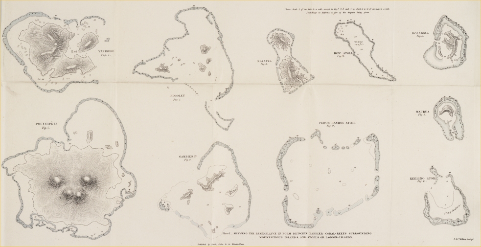

Preparing for Publication, by the same Author.
~~~~~~~~~~~~
PART II.
GEOLOGICAL OBSERVATIONS
ON THE
VOLCANIC ISLANDS
VISITED DURING THE VOYAGE OF THE BEAGLE,
(UNDER THE COMMAND OF CAPTAIN FITZROY, R.N.;)
TOGETHER WITH
SOME BRIEF NOTICES ON THE GEOLOGY OF
AUSTRALIA,
NEW ZEALAND, AND THE CAPE OF GOOD HOPE.
————
PART III.
GEOLOGICAL OBSERVATIONS
ON THE SOUTHERN PARTS
OF
SOUTH AMERICA.
THE
ZOOLOGY
OF THE
VOYAGE OF THE BEAGLE,
(UNDER THE COMMAND OF CAPTAIN FITZROY, R.N.)
EDITED AND SUPERINTENDED BY
CHARLES DARWIN, M.A., F.R.S., F.G.S.,
NATURALIST TO THE EXPEDITION.
~~~~~~~~~~~~
Parts now Complete.
PART I.—FOSSIL MAMMALIA. By RICHARD OWEN, Esq. F.R.S., Corres. Memb. of the Institute of France. With a Geological Introduction by Mr. Darwin, Price 1l. 10s.
PART II.—MAMMALIA. By GEORGE R. WATERHOUSE, Esq., Curator to the Zoological Society. With Notices of their Habits and Ranges, by Mr. Darwin. Price 1l 18s.
PART III.—BIRDS. By JOHN GOULD, Esq., F.L.S. With Notices of their Habits and Ranges, by Mr. Darwin. Price 2l. 15s.
PART IV.—FISH. By the Rev. LEONARD JENYNS, M.A., F.L.S.
Price 1l. 14s.
————
Two more Numbers, on Reptiles and Amphibia, by THOMAS
BELL,
Esq.,
F.R.S., F.L.S., will complete this Work.
May, 1842.
A
Catalogue
OF
INTERESTING WORKS,
IN THE PRESS OR RECENTLY PUBLISHED BY
SMITH, ELDER AND CO.
65, CORNHILL, LONDON.
————————————————
Preparing for Publication.
————
OBSERVATIONS IN THE SOUTHERN HEMISPHERE,
MADE DURING A RECENT RESIDENCE AT
THE CAPE OF GOOD HOPE.
By SIR JOHN HERSCHEL, Bart., F.R.S., &c.
To be Illustrated by numerous Plates.
~~~~~~~~~~~~
Nearly ready, in Two Volumes Demy 8vo., with Plates.
NOTES AND OBSERVATIONS ON
THE IONIAN ISLANDS AND MALTA,
WITH SOME REMARKS ON
CONSTANTINOPLE AND TURKEY;
And on the system of Quarantine, as at present conducted.
By JOHN DAVY, M.D., F.R.S.
~~~~~~~~~~~~
THE MODERN HISTORY AND CONDITION OF EGYPT.
ITS CLIMATE, DISEASES, AND CAPABILITIES;
Comprising the Proceedings of Mahommed Ali Pascha, from 1829 to 1842, with Illustrations of Scripture History, The Fulfilment of Prophecy, and the Progress of Civilization in the East.
By W. HOLT YATES, M.D., &c. &c.
In Two Volumes 8vo., with Illustrations.
Preparing for publication.
WITH THE APPROVAL OF THE LORDS COMMISSIONERS
OF HER
MAJESTY'S TREASURY.
GEOLOGICAL OBSERVATIONS
MADE DURING
THE VOYAGE OF HER MAJESTY'S SHIP BEAGLE,
Under the Command of Captain Fitzroy, R.N.
PART 1.—ON CORAL FORMATIONS.
PART 2.—ON THE VOLCANIC ISLANDS OF THE ATLANTIC AND PACIFIC OCEANS,
(Together with a brief Notice of the Geology of the Cape of Good Hope and of part of Australia.)
PART 3.—ON SOUTH AMERICA.
By CHARLES DARWIN, M.A., F.R.S., Sec. G.S., &c.
In 3 Vols., 8vo., with numerous Maps and Sections.
~~~~~~~~~~~~
THE JOURNAL OF AN EXPEDITION INTO
THE INTERIOR OF SOUTHERN AFRICA,
Fitted out in 1836, by the "Cape of Good Hope Association for Exploring Central Africa." Comprising an Authentic Narrative of the Travels and Discoveries of the Expedition; an Account of the Manners and Customs of the Native Tribes; and of the Natural Productions, Aspect, and Physical Capabilities of the Country.
By ANDREW SMITH, M.D.
Surgeon to the Forces, and Director of the Expedition.
To be Illustrated by a Map, and numerous Plates of African Scenery; and of the Dresses, Weapons, Dances, Religious Ceremonies, &c. of the Natives.
~~~~~~~~~~~~
FRIENDSHIP'S OFFERING,
AND
WINTER'S WREATH;
A Literary Album, and Christmas and New Year's Present, for 1843. The Twentieth Year of its Publication.
Price 12s. in full gilt binding, elegantly embossed.
"This most beautiful Annual enjoys the merit of having been the SECOND in existence of all those that now contest with it the palm of celebrity; and it is no exaggeration to say, that both in literary talent and pictorial embellishment it fully maintains the distinguished rank to which its priority of existence gives it a nominal title."
MONTHLY MAGAZINE.
Just Published.
THE RELIGIOUS HISTORY OF MAN,
In which Religion and Superstition are traced from their source.
By D. MORISON.
The Second Edition, enlarged. Foolscap 8vo., Price 6s. cloth.
~~~~~~~~~~~~
A COMPREHENSIVE HISTORY OF THE WOOLLEN TRADE
From the earliest Records to the present Period, comprising the Woollen and Worsted Manufactures, and the Natural and Commercial History of Sheep, with the various Breeds, and Modes of Management in different Countries.
By JAMES BISCHOFF, Esq.
In Two large Volumes, 8vo., Price 1l. 6s. cloth.
~~~~~~~~~~~~
A COMPREHENSIVE HISTORY OF THE IRON TRADE,
THROUGHOUT THE WORLD,
From the earliest Records to the present Time. With an Appendix, containing Official Tables, and other public Documents.
By HARRY SCRIVENOR, Esq., Blaenavon.
In One Volume Demy 8vo. Price 15s. cloth.
"Mr. Scrivenor's History is written with elaborate research and anxious care, and goes into and exhausts the entire subject; it contains numerous facts full of interest to common readers."—TAIT's MAGAZINE.
~~~~~~~~~~~~
A FAMILIAR EXPLANATION OF
THE NATURE, ADVANTAGES, AND IMPORTANCE OF
ASSURANCES UPON LIVES,
And the various Purposes to which they may be usefully Applied: including also a particular Account of the routine required for Effecting a Policy; and of the different systems of Life Assurance now in use, the Principles, Terms, and Tables of Seventy London Assurance Offices, &c.
By LEWIS POCOCK, F.S.A.
In Post 8vo., Price 7s. cloth.
"There are no technicalities in Mr. Pocock's work to prevent its being useful to all; and those, therefore, who are likely to have recourse to Life Insurance will do wisely in consulting this familiar explanation of its nature and advantages."—GLOBE.
~~~~~~~~~~~~
THE HISTORY OF THE REPUBLIC OF TEXAS,
From the Discovery of the country up to the present Time; with a description of the Soil, Climate, General Resources, &c., and a New Map.
By N. DORAN MAILLARD, Esq.
Demy 8vo., Price 15s. cloth.
"A picture of Texas and the Texans, no doubt a faithful one. There is much too, in this volume, which we should recommend to the careful perusal of Lord Aberdeen."
NEW MONTHLY MAGAZINE.
COMPANION TO SOUTHEY'S LIFE OF NELSON.
THE LIFE OF ADMIRAL VISCOUNT EXMOUTH;
Drawn up from Official and other authentic Documents supplied by his Family and Friends.
By EDWARD OSLER, Esq.
New Edition, fcp. 8vo., Price 6s. cloth, with a Portrait and five other Plates.
"Here is a valuable addition to our naval biography; a book not to be read by Englishmen without pride of heart. The name of Exmouth occupies on honourable place beside those of Nelson and Collingwood; his services were hardly less numerous or brilliant than theirs."—ATHENÆUM.
~~~~~~~~~~~~
HOOD'S OWN;
OR,
LAUGHTER FROM YEAR TO YEAR:
Being former runnings of his comic vein, with an infusion of new blood for general circulation.
"This Volume contains all the choice bits of the Comic Annuals: every page sparkles with wit and genuine humour; while the abundant illustrations would provoke mirth from the most cynical philosopher."
It comprises 570 closely printed pages, Demy 8vo., with nearly 300 Wood Cuts, and a Portrait of the Author, handsomely bound, Price 13s, cloth gilt.
MR. HOOD'S LAST WORK.
UP THE RHINE.
The Second Edition, Illustrated by numerous characteristic Cuts.
"One of the very best Guide Books for travellers on the Rhine, and withal irresistibly diverting."
Price 12s. cloth gilt.
~~~~~~~~~~~~
MADEIRA, LISBON, &C.
———
THE INVALID'S GUIDE TO MADEIRA;
With a Description of Teneriffe, Lisbon, Cintra, and Mafra, and a Vocabulary of the Portuguese and English Languages.
By WILLIAM WHITE COOPER, M.R.C.S., Surgeon to the Hon. Artillery Company.
In 1 Vol., fcp. 8vo., Price 4s. cloth gilt.
"There has recently been published a small work by Mr. Cooper, which may be consulted with advantage."—SIR JAMES CLARK on Climate.
~~~~~~~~~~~~
THE BENGAL AND AGRA GUIDE AND GAZETTEER;
Containing a Geographical and Statistical Account of India, Regulations of the Indian Government, History, the Indian Calendar, complete Army and Civil Official List; the whole comprising a classified body of information concerning India of an extent and variety hitherto unattempted.
In Two Large 8vo. Volumes, Price 2l. cloth.
Oriental Publications.
BY WILLIAM CARMICHAEL SMYTH, ESQ.
Late of the Hon. E. I. Company's Bengal Civil Service.
1.
THE HINDOOSTANEE INTERPRETER:
Containing the Rudiments of Hindoostanee Grammar; an extensive Vocabulary, English and Hindoostanee; and a useful Collection of Dialogues.
1 Vol. 8vo., Price 8s. boards.
2.
THE HINDOOSTANEE JEST BOOK:
Containing a choice collection of Humorous Stories in Arabic and Roman Characters; to which is added a Hindoostanee Poem, by MEER MOOHUMMUD TUGEE.
Second Edition, 8vo., Price 10s. 6d.
3.
THE PERSIAN MOONSHEE:
Containing a copious Grammar, and a series of entertaining Stories; also the PUND-NAMU of Shykh-Sadee, being a compendium of Ethics, in verse, by that celebrated poet; to which is added, forms of Addresses, Petitions, Citations, Bonds, &c. The whole in the Arabic and Roman Characters; together with an ENGLISH TRANSLATION.
Second Edition, revised, corrected, and translated into the Roman Character.
Vol. I., Price 12s.
4.
A DICTIONARY, HINDOOSTANEE AND ENGLISH.
Abridged from the Quarto Edition of Major JOSEPH TAYLOR, as edited by the late W. HUNTER, M.D.; with the Appendix.
Complete in 1 thick 8vo. Vol., Price 3l. 3s. boards.
~~~~~~~~~~~~
In a neat Portfolio, containing 5 Engravings, 15 inches by 10, with Descriptive Letterpress.
Dedicated, By Permission, to Her Majesty.
THE ORIENTAL PORTFOLIO:
Being a Series of Illustrations of the Scenery, Antiquities, Architecture, Manners, Costumes, &c. of the East. From original Sketches in the collections of Lord William Bentinck, K.C.B., Captain R. M. Grindley, Lady Wilmot Horton, Sir Henry Willock, K.L.S., Thomas Bacon, Esq., James Baillie Fraser, Esq., and other travellers. The Literary department of the work under the superintendence of HORACE H. WILSON, Esq., M.A.F.R.S. &c. &c. In Parts, Price 1l. 1s. each.
The object of this undertaking is to supply what has long been felt to be a desideratum; namely, Graphic Illustrations of the Scenery, Antiquities, Architecture, Manners, Costumes, &c. of the East, which, as the theatre of so many brilliant military achievements, and such extensive commercial enterprize, is daily increasing in interesting with the British Public.
The Drawings for the Work are made by the first Artists in the Kingdom, from the original sketches taken on the spot.
HINDOOSTANEE PHILOLOGY.
A DICTIONARY ENGLISH AND HINDOOSTANEE;
With a Grammatical Introduction.
By JOHN BORTHWICK GILCHRIST, LL.D.
Hindoostanee Professor in the College of Fort William.
Quarto boards, Price 2l. 2s.
~~~~~~~~~~~~
THE MANNERS AND CUSTOMS OF SOCIETY IN INDIA;
Including Scenes at the Mofussil Stations, interspersed with Characteristic Tales and Anecdotes: to which is added
A GUIDE TO CADETS
And other Young Gentlemen, during their first Years' Residence in India.
By MRS. MAJOR CLEMONS.
In 1 Vol., Post 8vo., Price 9s. cloth lettered.
"We need not recommend this book; the space we have given to it is an ample proof of the pleasure we have enjoyed in its perusal. We earnestly advise every person interested in India to read it."—ATLAS.
~~~~~~~~~~~~
MRS. POSTANS' CUTCH;
OR,
RANDOM SKETCHES,
Taken during a Residence in one of the Northern Provinces of Western India; interspersed with Legends and Traditions.
By Mrs. POSTANS.
In 1 Vol. 8vo., with numerous coloured Engravings and Woodcuts, Price 14s. cloth boards.
"A more instructive or entertaining volume than this it has not been our fortune to meet with for a long time."—ATHENÆUM.
~~~~~~~~~~~~
THE TROPICAL AGRICULTURIST:
A Practical Treatise on the Cultivation and Management of various Productions suited to Tropical Climates, and capable of advantageous production in our Colonies, &c.
By GEORGE RICHARDSON PORTER.
In Demy 8vo., with 45 Botanical Plates, Price 21s.
By the same Author,
THE NATURE AND PROPERTIES OF THE SUGAR CANE;
With Practical Directions for the Improvement of its Culture, and the Manufacture of its Products.
Second Edition. With Plates.
"These valuable volumes open to colonial residents such a mine of hitherto concealed wealth, that every proprietor, emigrant, or person interested in the success of an emigrant friend, ought to procure a copy as their surest guide to fortune."
THE ONLY COMPLETE AND UNIFORM EDITION OF THE WORKS OF SIR HUMPHRY DAVY.
THE LIFE AND COLLECTED
WORKS
OF SIR HUMPHRY DAVY, BART.
FOREIGN ASSOCIATE OF THE INSTITUTE OF FRANCE &c.
Edited by his Brother, JOHN DAVY, M.D. F.R.S.
Now complete, in 9 Vols. post 8vo., Price 10s. 6d. each, in cloth binding.
Contents of the Volumes;—sold separately.
VOL. I.
THE LIFE OF SIR H. DAVY, WITH A PORTRAIT.
'This biography is admirably written—correct details, full of instruction, and amusing throughout."—LONDON REVIEW.
VOL. II.
THE WHOLE OF SIR H. DAVY'S EARLY MISCELLANEOUS PAPERS,
FROM 1799 TO 1805;
WITH AN INTRODUCTORY LECTURE, AND OUTLINES OF LECTURES ON CHEMISTRY DELIVERED IN 1802 AND 1804.
VOL. III.
RESEARCHES ON NITROUS OXIDE,
AND THE COMBINATION OF OXYGEN AND AZOTE, AND ON THE
RESPIRATION OF NITROUS OXIDE AND OTHER GASES.
VOL. IV.
ELEMENTS OF CHEMICAL PHILOSOPHY.
WITH TWELVE PLATES OF CHEMICAL APPARATUS.
VOLS. V. AND VI.
BAKERIAN LECTURES,
AND OTHER PAPERS IN PHILOSOPHICAL TRANSACTIONS, AND JOURNAL OF THE ROYAL INSTITUTION. WITH NUMEROUS ENGRAVINGS.
VOLS. VII. AND VIII.
ELEMENTS OF AGRICULTURAL CHEMISTRY.
DISCOURSES DELIVERED BEFORE THE ROYAL SOCIETY, MISCELLANEOUS LECTURES, AND EXTRACTS FROM LECTURES. WITH MANY PLATES.
VOL IX.
SALMONIA, AND CONSOLATION IN TRAVEL.
*** This new and uniform edition of the Writings of Sir Humphry Davy embraces the whole of his Works, during the space of thirty years (1799 to 1829), a period memorable in the History of Chemistry, and made so in no small degree by his own Discoveries.
RESEARCHES, PHYSIOLOGICAL AND ANATOMICAL.
By JOHN DAVY, M.D. F.R.S. &c.
Illustrated by numerous Engravings.
The principal subjects treated of are Animal Electricity;—Animal Heat;—the Temperature of different Animals;—Pneumothorax in connexion with the Absorption of Gases by Serous and Mucous Membranes;—the Properties of the Blood in Health and Disease;—the Properties of different Animal Textures;—the Putrefactive Process;—the Preservation of Anatomical Preparations;—the Effects of the Poison of certain Serpents;—the Structure of the Heart of Batrachian Animals, &c. &c.
In 2 Vols. 8vo., Price 30s. bound in cloth.
"The subjects treated by the author are extremely numerous and interesting; several new facts in the physiology of animals are brought forward, and some curious and instructive experiments are explained and illustrated with remarkable felicity."
MONTHLY CHRONICLE.
"This work is written with a clearness and simplicity which renders its scientific details readily comprehensible."—HERALD.
~~~~~~~~~~~~
NEW WORK ON GEOLOGICAL STUDY,
Uniform with the BRIDGEWATER TREATISES.
——
THE CERTAINTIES OF GEOLOGY.
By W. SIDNEY GIBSON, Esq., F.G.S. Price 10s. 6d. cloth.
"An able and elaborate treatise, to demonstrate that the science of geology is not inconsistent with Christian belief."—LITERARY GAZETTE.
"A work calculated to arrest the serious attention of every Christian reader."
BRITANNIA.
"The clearest and most comprehensive introduction to the science of geology which has yet fallen under our notice. The principles of geology are moreover explained with a perspicuity and a completeness which we may look for in vain in other works professing the same object."—UNITED SERVICE GAZETTE.
~~~~~~~~~~~~
THE FIRST VOLUME OF THE
TRANSACTIONS OF THE METEOROLOGICAL SOCIETY OF LONDON.
Illustrated by a Synoptical Chart and numerous Diagrams.
Royal 8vo., Price 2l. 2s.
The first paper in the volume, entitled
DIRECTIONS FOR MAKING METEOROLOGICAL OBSERVATIONS ON LAND OR AT SEA,
By R. C. WOODS, Esq.
May be purchased separately, Price 2s. 6d.
IMPORTANT SCIENTIFIC WORKS,
NOW PUBLISHING, UNDER THE AUTHORITY OF GOVERNMENT.
1.
In Royal 4to. Parts, Price 10s. and 12s. each, containing on an average Ten Coloured Engravings, with descriptive Letterpress,
ILLUSTRATIONS OF
THE ZOOLOGY OF SOUTH AFRICA:
Comprising Figures of all the new species of Quadrupeds, Birds, Reptiles, and Fishes, obtained during the Expedition fitted out by "The Cape of Good Hope Association for exploring Central Africa," in the years 1834, 1835, and 1836, with Letterpress Descriptions, and a Summary of African Zoology.
By ANDREW SMITH, M.D., Surgeon to the Forces, and Director of the Expedition.
*** The whole of the Plates are engraved in the highest style of Art, from the Original Drawings taken expressly for this work, and beautifully coloured after Nature.
15 Parts are now published.
2.
Uniform with the above.
THE ZOOLOGY OF THE VOYAGE OF H.M.S. BEAGLE,
UNDER THE COMMAND OF CAPTAIN FITZROY, R.N.
DURING THE YEARS 1832 TO 1836.
Edited and superintended by CHARLES DARWIN, Esq., M.A. Sec. G.S.
Naturalist to the Expedition.
Comprising highly-finished representations of the most novel and interesting objects in Natural History, collected during the voyage of the Beagle, with descriptive Letterpress, and a general Sketch of the Zoology of the Southern Part of South America.
Figures are given of many species of animals hitherto unknown or but imperfectly described, together with an account of their habits, ranges, and places of habitation.
The collections were chiefly made in the provinces bordering on the Rio Plata, in Patagonia, the Falkland Islands, Tierra del Fuego, Chili, and the Galapagos Archipelago in the Pacific.
17 Parts are now published, and 2 more will complete the Work.
*** In order to secure to science the full advantage of Discoveries in Natural History, the Lords Commissioners of Her Majesty's Treasury have been pleased to make a liberal grant of money towards defraying part of the expenses of these two important publications. They have, in consequence, been undertaken on a scale worthy of the high patronage thus received, and are offered to the public at a much lower price than would otherwise have been possible.
~~~~~~~~~~~~
OUTLINES OF NAVAL ROUTINE;
Being a Concise and Complete Manual in Fitting, Re-fitting, Quartering, Stationing, making and shortening Sail, Heaving down, Rigging Shears, and, in short, performing all the ordinary duties of a Man-of-War, according to the best practice.
By Lieutenant ALEXANDER D. FORDYCE, R.N.
In Royal 8vo., Price 10s. 6d. boards.
The Anglo-Saxon Language.
1.
A GRAMMAR OF THE ANGLO-SAXON TONGUE,
WITH A PRAXIS
By ERASMUS RASK, of the University of Copenhagen.
Translated by BENJAMIN THORPE, F.S.A.
In 1 Vol. 8vo, Price 12s. boards.
2.
A SELECTION, IN PROSE AND VERSE,
FROM
ANGLO-SAXON AUTHORS, OF VARIOUS AGES:
With a Glossary. Designed chiefly as a First Book for Students.
By BENJAMIN THORPE, F.S.A.
In 8vo., Price 20s. bds.
3.
THE ANGLO-SAXON VERSION
OF THE
STORY OF APOLLONIUS OF TYRE,
Upon which is founded the Play of "Pericles," attributed to Shakspeare. From a MS. in the Library of C. C. C., Cambridge; with a Literal Translation, &c.
By BENJAMIN THORPE, F.S.A.
In small 8vo., Price 6s. bds.
~~~~~~~~~~~~
CHINA OPENED;
Or, a Display of the Topography, History, Customs, Manners, Arts, Manufactures, Commerce, Literature, Religion, Jurisprudence, &c. of the Chinese Empire.
By the Rev. CHARLES GUTZLAFF. Revised by the Rev. ANDREW REED, D.D.
In 2 Vols., Post 8vo., with a New Map of the Chinese Empire, Price 1l 4s. cloth boards.
"We obtain from these volumes more information of a practical kind than from any other publication; a closer view of the Domestic life of the Chinese — of the public institutions — the manufactories — natural resources — and literature. The work in fact is full of information, gathered with diligence, and fairly leaves the English reader without any excuse for ignorance on the subject."—ATLAS.
"This is by far the most interesting, complete, and valuable account of the Chinese Empire that has yet been published."—SUN.
A HISTORY OF UPPER AND LOWER CALIFORNIA,
From their first Discovery to the Present Time; comprising an Account of the Climate, Soil, Natural Productions, Agriculture, Commerce, &c.; a full View of the Missionary Establishments, and condition of the Free and Domesticated Indians.
By ALEXANDER FORBES, Esq.
With an Appendix relating to Steam Navigation in the Pacific.
In 1 Volume, demy 8vo., with a New Map by Arrowsmith, Plans of the Harbour, and numerous Engravings, Price 14s.
"This is a very interesting and important work, and will make the public well acquainted with an extensive country known to Europe nearly three hundred years, yet its history, till the appearance of this volume, has been nearly a blank."—SUNDAY TIMES.
~~~~~~~~~~~~
A NARRATIVE OF
TWO EXPEDITIONS INTO THE INTERIOR OF AUSTRALIA,
Undertaken by Captain CHARLES STURT, of the 39th Regiment, by order of the Colonial Government to ascertain the Nature of the Country to the West and North-west of the Colony of New South Wales.
Second Edition, 2 Volumes 8vo., Price 28s. illustrated with a large Map of Australia, by Arrowsmith; Charts, Fossils, Landscapes, and beautifully coloured Plates of Birds, &c.
"We heartily recommend these volumes to public notice. They are full of interest, well and modestly written, carefully illustrated, and, on the whole, make us better acquainted with the interior of Australia and its native tribes, than any other work we have met with."—ATHENÆUM.
~~~~~~~~~~~~
AN ACCOUNT OF THE SETTLEMENTS OF THE NEW ZEALAND COMPANY,
From Personal Observations during a residence there.
By the HON. HENRY WILLIAM PETRE.
"This is a valuable contribution to our sources of information respecting New Zealand, and the best proof of the Author's very favourable opinion of the country, is his making immediate arrangements to return there as a Colonist."
In Demy 8vo., with a Map and Plates. Fourth Edition. Price 3s. cloth.
~~~~~~~~~~~~
NEW ZEALAND, SOUTH AUSTRALIA, AND NEW SOUTH WALES:
A Record of recent Travels in these Colonies, with especial reference to Emigration, and the advantageous employment of Labour and Capital.
By R. G. JAMESON, Esq.
"Mr. Jameson is an intelligent and unprejudiced observer, and has made good use of his faculties."—SPECTATOR.
Post 8vo., Price 8s. cloth, with Maps and Plates.
A PRACTICAL TREATISE ON BREWING,
Based on Chemical and Economical principles; with Formulæ for Public Brewers, and Instructions for Private Families.
By WILLIAM BLACK.
Second Edition, much enlarged and improved, in small 8vo.
(Revised by DR. BIRKBECK.)
Price 12s. in neat cloth binding.
"This very useful work re-appears with many valuable additions to its former instructions and information. And the art of Brewing can no longer be a mystery or a matter of difficulty; and neither the wholesale nor the private brewer should be without it."
ARGUS.
~~~~~~~~~~~~
MEDICAL GUIDE FOR MOTHERS,
In Pregnancy, Accouchement, Suckling, Weaning, &c., and in some of the more important diseases of Infancy.
With an Appendix on the successful Cure of Consumption, by a New Remedy.
By J. R. HANCORN, Member of the Royal College of Surgeons, &c.
Foolscap 8vo., Price 5s. cloth.
~~~~~~~~~~~~
THE LAST OF THE PLANTAGENETS:
An Historical Narrative, illustrating some of the Public Events and Domestic and Ecclesiastical Manners of the Fifteenth and Sixteenth Centuries.
Third Edition, in 1 Vol. fcp. 8vo., Price 7s. 6d. cloth boards.
"This is a work that must make its way into a permanent place in our literature. The quaintness of its language, the touching simplicity of its descriptions and dialogues, and the reverential spirit of love which breathes through it, will insure it a welcome reception amongst all readers of refined taste and discernment."—ATLAS.
~~~~~~~~~~~~
THE BYRON GALLERY:
A series of 36 Historical Embellishments to illustrate the Poetical Works of Lord Byron; beautifully engraved from Drawings and Paintings by the most celebrated Artists, and adapted by their size and excellence to bind up with and embellish every edition published in England of LORD BYRON'S WORKS, and also the various sizes and editions published in France, Germany, and America; ample directions being given for placing them in the respective editions. Elegantly bound in morocco, Price 1l. 15s., forming a splendid Ornament for the Drawing-Room Table.
"Adequately to describe the delicate beauty of these splendid plates does not appear to lie within the power of language. There is not an admirer of the works of the departed noble poet who can feel satisfied that he has a perfect edition of them, unless the 'Byron Gallery' be attached to it. There is no instance in which excellence in poetry and the arts are so admirably combined."—IMPERIAL MAGAZINE.
STANFIELD'S COAST SCENERY;
COMPRISING
A SERIES OF 40 PICTURESQUE VIEWS IN THE BRITISH CHANNEL.
From Original Drawings taken expressly for this publication,
By CLARKSON STANFIELD, Esq., R.A.
This work is published in super-royal 8vo., containing beautifully-finished Line Engravings, by the most eminent Artists, accompanied by highly interesting topographical descriptions, forming altogether one of the most splendid works of the kind which has ever appeared, and may now be had, done up in appropriate and elegant morocco binding, Price 32s, 6d.
"It seems almost a sin against patriotism, as well as good taste, not to possess oneself of a work so peculiarly national, and so exceedingly beautiful."—METROPOLITAN.
~~~~~~~~~~~~
KONRAD VALLENROD,
An Historical Tale, from the Prussian and Lithuanian Annals;
Translated from the Polish of ADAM MICKIEWICZ,
By H. CATTLEY.
In 1 Volume Demy 8vo., Price 7s.; with Illustrations, handsomely bound.
"Breathes the noble spirit of the original so freely and so forcibly, that it is almost as fresh and true in one language as in the other."—ATLAS.
~~~~~~~~~~~~
THE VOW OF THE GILEADITE,
A Lyric Narrative.
By WILLIAM BROWN GALLOWAY, MA., Curate of Barnard Castle.
The profits, if any, will be given to the Poor.
"The fine flowing style in which it is written, and the pure and hallowed feeling which seems to have dictated every line, are qualities sufficient to ensure for this Poem a lasting reputation."—CITY CHRONICLE.
Foolscap 8vo., Price 5s. cloth.
~~~~~~~~~~~~
UNDER THE PATRONAGE OF THE HIGHLAND SOCIETY OF LONDON.
A LITERAL TRANSLATION OF THE GENUINE REMAINS OF OSSIAN,
With a Preliminary Dissertation, and an Appendix.
By PATRICK MACGREGOR, M.A.
In 1 Volume, Post 8vo., Price 12s. neatly bound.
"Those persons who wish to cultivate an acquaintance with the Celtic Language, will find Mr. McGregor's volume a valuable and agreeable assistant."—TIMES.
THE PROGRESS OF CREATION,
CONSIDERED WITH REFERENCE TO THE
PRESENT CONDITION OF THE EARTH.
An interesting and useful work for young People.
By MARY ROBERTS, Author of "Annals of My Village," &c. &c.
In small 8vo., beautifully illustrated, Price 7s. in fancy cloth.
"We have seldom met with a work, in which instruction and entertainment are more happily blended."—TIMES.
"This beautiful volume forms an instructive collection of striking facts, interspersed with amiable reflections."—SPECTATOR.
~~~~~~~~~~~~
THE LIFE-BOOK OF A LABOURER.
By a WORKING CLERGYMAN.
CONTENS:— The King's Heart — Links of the Past — Newnham Paddex and Mr. Blunt — The Grave of Byron — The Late Lady Howe — A Fastidious Parish — Bishops and their Relatives — Lord Viscount Brome — M. J. J. — Laud's Church Yard — The Rough Clergyman — The Tennis Ball of Fortune — The Dying Request of the Infidels Daughter — The Clergyman Alchemist — What say you to a Ghost Story? — Lady Huntingdon's resting Place —Arnsby and Robert Hall — The Deserted Prophetess — The Crown Prince — Religion and Insanity — Dr. Hawker and Mrs. Jordan, &c. &c.
In 1 Vol. small 8vo., Price 7s. cloth boards.
"It is the pious offering of one who may be deemed a proper follower in the footsteps of that good man, Leigh Richmond."—ARGUS.
"This volume reminds us forcibly of that most delightful of all biographies, 'The Doctor,' to which indeed it is little if at all inferior."—BRITANNIA.
~~~~~~~~~~~~
A VALUABLE AND INSTRUCTIVE PRESENT FOR THE YOUNG.
THE PARENT'S CABINET OF AMUSEMENT AND INSTRUCTION.
In 6 neatly bound Vols., Price 3s. 6d. each.
Each volume of this useful and instructive little work comprises a variety of information on different subjects—Natural History, Biography, Travels, &c.; Tales, original and selected; and animated Conversations on the objects that daily surround young people.
The various tales and subjects are illustrated with Woodcuts. Each volume is complete in itself, and may be purchased separately.
"Every parent at all interested in his children must have felt the difficulty of providing suitable reading for them in their hours of amusement. This little work presents these advantages in a considerable degree, as it contains just that description of reading which will be beneficial to young children."—QUARTERLY JOURNAL OF EDUCATION.
GRESHAM PRIZE ESSAYS
———
ESSAY ON THE
LIFE AND INSTITUTIONS OF OFFA, KING OF MERCIA,
A. D. 755-794.
By the REV. HENRY MACKENZIE, M.A.
In 8vo., Price 3s. 6d. in cloth, gilt leaves.
"A very scholarly composition, displaying much research and information respecting the Anglo-Saxon institutions."—SPECTATOR.
———
PRIZE ESSAY, 1840.
THE OBLIGATIONS OF LITERATURE
TO THE
MOTHERS OF ENGLAND.
By CAROLINE A. HALSTED.
In 1 Volume Post 8vo., Price 5s., neatly bound in cloth.
"The object of the writer has been to show the services rendered by the mothers of England to religion and the state, and to science and learning generally; and the examples adduced display considerable knowledge and research, and are always happily selected and placed in the most attractive point of view."—BRITANNIA.
~~~~~~~~~~~~
THE LIFE OF MARGARET BEAUFORT,
COUNTESS OF RICHMOND AND DERBY.
AND MOTHER OF KING HENRY THE SEVENTH,
Foundress of Christ's and of St. John's College, Oxford;
Being the Historical Memoir for which the Honorary Premium was awarded by the Directors of the Gresham Commemoration, Crosby Hall.
By CAROLINE A. HALSTED, Author of "Investigation," &c.
In 1 Vol. Demy 8vo., with a Portrait, Price 12s.
"This work cannot fail of success. The subject is deeply interesting, and has been hitherto almost unexplored. The style is chaste and correct, and it has high claims to popularity wide and permanent. On many topics the authoress has accumulated some valuable historical details from sources which have not hitherto been consulted, and has thus compiled a work which, if not entitled to rank amongst the 'curiosities of literature,' is at least one of the most interesting and instructive books of the season."—ATLAS.
~~~~~~~~~~~~
INVESTIGATION;
OR, TRAVELS IN THE BOUDOIR.
By CAROLINE A. HALSTED, Author of "The Life of Margaret Beaufort," &c. &c.
Small 8vo., with highly-finished Plates, 7s. in embossed cloth.
This is an elegantly-written and highly-instructive work for young people, in which a general knowledge of various interesting topics, connected with every-day life, is presented to the youthful mind in an attractive and amusing form.
SCENES IN THE HOP GARDENS.
In 1 Vol. small 8vo., neatly bound in cloth, with a Frontispiece and Vignette, Price 4s.
"There is a tone of unaffected but deep piety throughout this little work; the peculiar truths of the Gospel are kept in view, and reasons for adhering to the national worship of our land are forcibly laid down."—CHURCH OF ENGLAND MAGAZINE.
"We strongly recommend the little volume before us to the attention of our readers, and would strenuously advise its adoption as a present to the young, and a reward book to the senior classes in Sunday and other schools."—CHRISTIAN GUARDIAN.
~~~~~~~~~~~~
SOCIAL EVILS AND THEIR REMEDY:
A SERIES OF NARRATIVES
By the Rev. C. B. TAYLER, M.A.
The First Number, entitled "THE MECHANIC," was pronounced to be "One of the most useful and interesting publications that had issued from the press."
The following are the Contents of the different Numbers, Price 1s. 6d. each.
| II. THE LADY AND THE LADY'S MAID. | VI. LIVE AND LET LIVE; OR, THE MANCHESTER WEAVERS. |
| III. THE PASTOR OF DRONFELLS. | |
| IV. THE LABOURER AND HIS WIFE. | VII. THE SOLDIER. |
| V. THE COUNTRY TOWN. | VIII. THE LEASIDE FARM. |
Every two consecutive Numbers form a Volume, which may be procured, neatly bound, Price 4s. each.
"The design of Mr. Taylor is praiseworthy; his object being to counteract, by a series of tales illustrative of the power and necessity of religion in the daily and hourly concerns of life, 'the confusion of error with truth in MISS MARTINEAU'S ENTERTAINING STORIES:''—CHRISTIAN REMEMBRANCER.
~~~~~~~~~~~~
Works by Mrs. Ellis.
PICTURES OF PRIVATE LIFE;
THIRD EDITION.
Containing "An Apology for Fiction;" "The Hall and
the Cottage;" "Ellen Eskdale;"
"The Curate's Widow;" and "Marriage as
it may be."
Uniform with the above, the Second Series, comprising
"MISANTHROPY," AND "THE PAINS OF PLEASING."
The Third Series, containing a highly interesting narrative, under the title of
"PRETENSION."
By SARAH STICKNEY, now MRS. ELLIS.
Foolscap 8vo., beautifully illustrated, Price 7s. 6d. each, cloth extra; or 10s. 6d. elegantly bound in morocco.
"Sarah Stickney is an honour to her sex, and an ornament to literature. How rich in experience — how subtle in thought — how deep in knowledge — what pictures of real life she can call up by the magic of her pen! We would place her volumes in an exquisite small library, sacred to sabbath feelings and the heart's best moods, when love and charity and hope combine to throw over the mind that soft and tranquil glow only to be compared to the later glories of the day."—SPECTATOR.
"The aim of the writer is evidently to instruct as well as amuse, by offering these admirable sketches as beacons to warn the young, especially of her own sex, against the errors which have shipwrecked the happiness of so many."—GENTLEMAN'S MAGAZINE.
London: Printed by STEWART & MURRAY, Old Bailey.