[map]

[page break]
A
CHRONOLOGICAL HISTORY
OF THE
VOYAGES AND DISCOVERIES
IN THE
SOUTH SEA
OR
PACIFIC OCEAN.
PART III.
From the Year 1620, to the Year 1688.
ILLUSTRATED WITH CHARTS AND OTHER PLATES.
By JAMES BURNEY, 1750—1821.
CAPTAIN IN THE ROYAL NAVY.
LONDON:
PRINTED BY LUKE HANSARD AND SONS, NEAR LINCOLN'S-INN FIELDS; AND SOLD BY
G. AND W. NICOL, BOOKSELLERS TO HIS MAJESTY, AND T. PAYNE, PALL-MALL;
WILKIE AND ROBINSON, PATERNOSTER ROW; CADELL AND DAVIES, IN THE STRAND;
NORNAVILLE AND FELL, BOND-STREET; AND J. MURRAY, ALBEMARLE-STREET.
1813.
[page break]
[page break]
CONTENTS OF VOLUME III.
CHAPTER I.
Voyage of the Nassau Fleet, to the South Sea, and to the East Indies.
| Page | |
| Fleet fitted out from Holland against Peru. Commanded by Jacob l'Heremite | 2 |
| Cape de Verde Islands | 3 |
| I. St Vincent, and St Antonio. Sierra Leone | 4 |
| C. Lopez Gonsalvo. Bad water | 5 |
| I. St Thomas. Annobon | 7 |
| In Strait Le Maire | 9 |
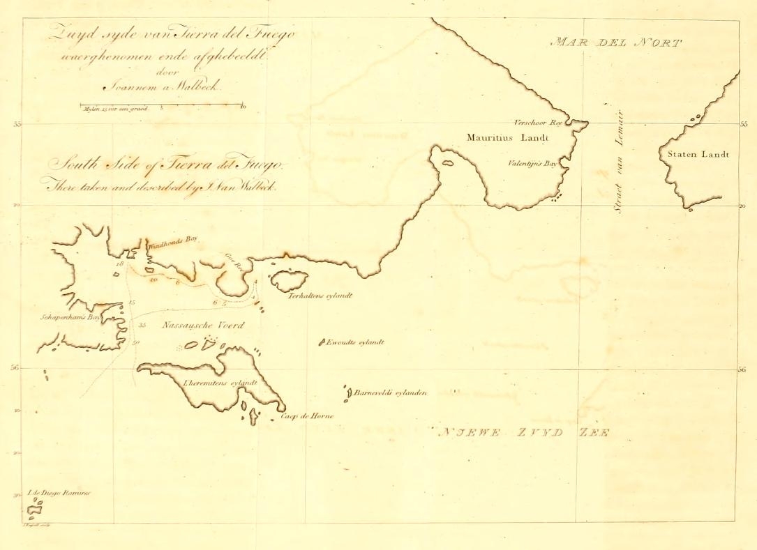
| Verschoor and Valentyn's Bay | 10 |
| Chart by Van Walbeck | ib. |
| Nassau Bay | 12 |
| Examination of the Coast round Nassau Bay. Description of the Inhabitants | 13—15 |
| Suarte Theunis | 17 |
| At Juan Fernandez | 18 |
| Failure of Attempt on Callao | 20 |
| Death of Jacob l'Heremite | 23 |
| Isle de Lima or de S. Lorenzo | 26 |
| Herbs found there | ib. |
| Guayaquil burnt | 27 |
| Islands Pescadores | 28 |
| Bay and good Watering place | ib. |
| Coast of New Spain | 30 |
| Occurrence at Port del Marques | 31 |
| Leave the American Coast | 32 |
| Islands and Reefs believed to be of San Bartolomé | 33 |
| At the Ladrones | 34 |
| Islands SW of the Ladrones | ib. |
| The Fleet arrives at the Molucca Islands | 35 |
| Death of Admiral Schapenham | 36 |
CHAP. II.
Of the early intercourse of Europeans with China, and their Settlements on the Island Formosa. Various other events to the year 1638.
| Page | |
| Settlement of the Portuguese at Macao | 39 |
| Formation of the Dutch East India Company | 40 |
| Contests of the Dutch with the Portuguese | ib. |
| The Ponghou Isles | 44 |
| Dutch War with the Chinese | ib. |
| They settle in Formosa | 48 |
| Harbour of Tayowan | ib. |
| Kelang | 49 |
| George Candidius | 50—52 |
| Death of W. Schouten | 53 |
| Spanish Ship wrecked at the Ladrones | ib. |
| Massacre of the Christians at Japan | ib. |
a
[page break]
CHAP. III.
Voyage of Captain Matthys Kwast to the Sea East of Japan.
CHAP. IV.
The Voyage of Captain Abel Jansen Tasman in the year 1642.
| Page | |
| Manuscript Journal of Captain Tasman's | 60 |
| Tasman sails from Batavia | 63 |
| At the Island Mauritius | ib. |
| Land discovered | 67 |
| Is named Van Diemen's Land | 68 |
| Frederik Hendrik's Bay | 70 |
| Other Land discovered, and named Staten Land [since, New Zealand] | 72 |
| Moordenaar's Bay | 73 |
| Drie Koningen Island | 79 |
| Pylstaart Island | 80 |
| Amsterdam Island | 81 |
| Amamocka Island | 86 |
| Island North of Amamocka | 89 |
| Prins Willem's Islands, and Heemskerk's Shoals | 89 |
| Onthona Java | 93 |
| Marquen Islands | 94 |
| Groehe Islands | 95 |
| Island St Jan | 96 |
| Ant. Kaan's Island. Cape Sta. Maria. Gerrit Denys Island. Vischer's Island | 97 |
| Salomon Sweert's Hoek | 99 |
| Coast of New Guinea | 100 |
| Vulcan's Island. Hooge Bergh | 102 |
| Islands Jamna and Arimoa | 103—4 |
| Islands Moa and Inson | 105 |
| Willem Schouten's Island | 107 |
| Return to Batavia | 110 |
CHAP. V.
Expedition of Hendrick Brouwer to Chili.
| Page | |
| Staten Land discovered to be an Island | 115 |
| Brouwer's Passage Eastward of Staten Island | 116 |
| Valentyn's Bay | ib. |
| At the Island Chiloe | 117 |
| Brouwer's Haven | 118 |
| Carel Mapu. Calibuco | 121 |
| The Llama or Peruvian Sheep | 122 |
| City of Castro | 124 |
| State of Chili | 126 |
| Death of Hendrick Brouwer | 129 |
| Island Donna Sebastiana | ib. |
| Of the name Puerto Ingles | 130 |
| Description of Brouwer's Haven | 131 |
| Inhabitants of Chiloe | ib. |
| Baldivia, City and River | 132 |
| Alliance formed between the Hollanders and People of Chili | 134 |
| Cawaw; a drink of the Chilese | 137 |
| Its similarity to the Kava of the South Sea Islands | 138—9 |
| The Hollanders depart from Chili | 144 |
| Passage East of Staten Land called Brouwer's Strait | 145 |
[page break]
CHAP. VI.
Voyage of the Ships Kastrikom and Breskens to the North of Japan.
| Page | |
| Of the knowledge previously obtained of Yesso and Eastern Tartary | 146 |
| The Ships Kastrikom and Breskens fitted out at Batavia | 150 |
| Publications concerning the Voyage | 151 |
| Instructions to the Commander | 152 |
| Ongelukkig Island | 154 |
| Land of Yesso | 155 |
| Staten Eylant | 156 |
| Compagnies Landt | ib. |
| Strait de Vries | ib. |
| Cape Van Patientee | 158 |
| Bay de Goede Hope | 159 |
| Description of Yesso, and the Inhabitants | ib. —165 |
| The Kastrikom in search of the Rich Islands | 166 |
| Course sailed by the Breskens | 167 |
| Port on the East side of Japan | 169 |
| Adventure of some Hollanders who landed there | 170—176 |
| Of Land seen by J. de Gama | 177 |
| Tristan d'Acunha Isles | ib. |
CHAP. VII.
Notices of a Second Voyage of Discovery by Tasman. Of the Amsterdam Stadt-house Map of the World; and of the Names Hollandia Nova and Zeelandia Nova.
| Page | |
| Second Voyage of Discovery by Tasman | 178 |
| Extract from his Instructions | 179 |
| Of the Name New Holland; on what occasion first applied to the Terra Australis | 181 |
| Amsterdam Stadt house Map of World | 181—182 |
| Zeelandia Nova | 183 |
CHAP. VIII.
Doubtful Relation of a Voyage by Bartholomew de Fonte.
| Page | |
| Time and manner of its first publication | 184 |
| Letter of de Fonte | 185—190 |
| Doubts respecting the reality of de Fonte's Voyage | 191 |
a 2
[page break]
CHAP. IX.
Brief Notice of the First entrance of the Russians into the Sea East of Asia. Narrative of the wreck of a Dutch Ship on the Island Quelpaert, and the captivity of her Crew in the Korea.
| Page | |
| First entrance of the Russians into the Sea East of Siberia | 196 |
| Dutch Ship wrecked on the Island Quelpaert | 197 |
| Narrative by Hendrick Hamel | 199—219 |
| His Description of the Kingdom of Korea | 219—227 |
| Remarks on Hamel's Description | 227 |
| Of the Korean and Chinese written characters | 230—236 |
CHAP. X.
Western Navigation from Europe to the East Indies. The Island Formosa taken from the Hollanders.
| Page | |
| Voyages of Jan Boon | 238 |
| Government of the Hollanders in Formosa | 240 |
| Are attacked by the Chinese | 249 |
| Fort Zealand besieged | 253 |
| Passage from the China Sea Southward against the Southern Monsoon | 254 |
| Succours arrive from Batavia | 256 |
| Fort Zealand surrendered to the Chinese General Koxinga | 261 |
| Of Koxinga and his Successors, Sovereigns of Formosa | 264—265 |
CHAP. XI.
Early instance of the use of Time Keepers at Sea. Of Islands marked in the Charts with the name Santa Tecla. Voyage of Jean Baptiste de la Follada.
| Page | |
| Account of the going of two Watches at Sea | 267 |
| Of the Islands Santa Tecla | 268 |
| J. Baptiste de la Follada | 269 |
| Fr. de Seyxas y Lovera | 270 |
[page break]
CHAP. XII.
Commencement of Missionary Undertakings to the Islands in the South Sea; and Settlement of the Ladrone Islands by the Spaniards.
| Page | |
| Mission to the Ladrones proposed by P. Luis de Sanvitores | 274 |
| Plan for a Mission to the Terra Australis by Abbé J. Paulmier | 275 |
| Of de Gonneville's Voyage | ib. |
| J. Paulmier, a descendant of Essemoric | 277 |
| Mission sent to the Ladrone Islands | 280 |
| Name of the Islands changed to that of the Marianas | 280 |
| The first Church built at Agadna | 284 |
| Pere Gobien; his Protestation | 286 |
| Unwillingness of the natives to be baptised | 288 |
| Forts built and the natives subjected | 289—292 |
| Padre de Sanvitores killed | 295 |
| 200 natives of the Philippines Islands ordered to strengthen the Mission | 297 |
| Severities exercised on the natives | 298 & seq. |
| Guahan abandoned by the greater part of the inhabitants | 300 |
| Don Ant. de Saravia appointed Governor; conciliates the natives and restores order | 300 |
| Death of Saravia | 302 |
| His Successors undertake the conquest of the Northern Isles | ib. |
| Eaton and Cowley, Buccaneers, at Guahan | 304—5 |
| Dampier, his description of the natives | 306 |
| Island named Carolina | 307 |
| Tyranny of the Spaniards. The Northern Isles wholly unpeopled and abandoned | 308 & seq. |
| Character and happy state of the natives at the first arrival of the Mission | 310 |
| Mismanagement of the Spaniards | 313—314 |
| Of the Chart of the Marianas by P. Alonso Lopez | 315 |
CHAP. XIII.
Voyage of Captain John Narbrough to Patagonia and Chili.
| Page | |
| Journals & Narratives of the Voyage | 316—318 |
| Letter from Captain Grenville Collins to M. Witsen | 319 |
| Journal kept by Capt. Narbrough | 320—371 |
| Cape de Verde Islands | 321 |
| Instructions to the Commander of the Bachelour | 323 |
| Seal's Bay. Spiring's Bay | 328 |
| Penguin Island | 329 |
| In Port Desire | ib. —338 |
| Watering places | 330—331 |
| Tower Rock | 336 |
| Bay before Port San Julian | 339 |
| In Port San Julian | 340 |
| Salt Pond | 342 |
| Natives | 343 |
| The Armadillo. The Huffer | 346 |
| Return to Port Desire | 346 |
| Figure of the Ship by the Natives | 347 |
| River Gallegos. Cape Virgin Mary | 348 |
| In the Strait of Magalhanes | 349—358 |
| Island Nuestra Sena del Socorro | 359 |
| Narbrough Island. Chiloe | 360 |
| No-man's Island | 361 |
| At Baldivia | ib. —369 |
| Description of the Port of Baldivia | 370 |
| Return to the Strait of Magalhanes | 371 |
| Tuesday Bay. Island Bay. Batchelor's River | ib. |
| Continuation of the narrative from Lieutenant Pecket's Journal | 372 |
| Remarks on the Voyage | 373—375 |
| Remarks on the different Charts of the Strait of Magalhanes | 376—382 |
[page break]
CHAP. XIV
Trading Voyages from Europe to the South Sea, by Strait le Maire. Attempt by the English East India company to re-establish their Trade with Japan. voyage of Thomas Peche to the Molucca and Philippine Islands, and in search of the Strait of Anian.
| Page | |
| Voyage of two Vessels from Holland to the South Sea | 383 |
| East Coast of Tierra del Fuego | ib. |
| Attempt made by the English to re-establish their Trade with Japan | 384—392 |
| Voyage of Thomas Peche | 392 |
| His search for the Strait of Anian | 393 |
| Publication of his Voyage | 394 |
CHAP. XV.
Voyage of Antonio de la Rochè. Discovery by the Japanese of the Island Bune-sima; with various other matters.
| Page | |
| Voyage of Antonio de la Rochè | 395—398 |
| He sails from Hamburgh | 396 |
| Sails on his return from the South Sea | 397 |
| Discovers Land to the East of Staten Island | ib. |
| La Rochè's Passage | ib. |
| Isla Grande of Ja Rochè | 398 |
| Doubts and conjectures concerning la Rochè's Discoveries | 399 & seq. |
| Island Buna-sima | 403 |
| Romance of a Voyage by Jaques Sadeur | ib. —404 |
CHAP. XVI.
Discoveries made by the Japanese to the North. Attempts of the Portuguese to renew their Trade with Japan. The name Carolinas given to Islands Southward of the Marianas. First Mission of the French Jesuits to China. Islas de 1688. Island Donna Maria de Lajara.
| Page | |
| Discoveries by the Japanese to the North of Japan | 405 |
| Japanese Ship wrecked near Macao | 406 |
| Attempts of the Portuguese to renew their trade with Japan | 407 |
| Carolinas Islands, or new Philippines | 410 |
| First introduction of the French Jesuits into China | 411 |
| Islas de 1688 | 412 |
| Island Donna Maria de Lajara | 413 |
[page break]
APPENDIX.
MEMOIR, Explanatory of a Chart of the Coast of China and the Sea Eastward, from the River of Canton to the Southern Islands of Japan.
(Being the Chart which fronts the Title page to this Volume).
| Page | |
| List of the Authorities on which the Chart is formed | 415 |
| Hessel Gerritz. Joannes Van Keulen | 419 |
| Coast of China | 420—425 |
| Missionary Survey | 420 |
| Chinese Maps of China | ib. |
| Korea | 426 |
| Quelpaert | 427 |
| Japanese Islands | 427 |
| Formosa | 429 |
| Banks of Formosa | 431 |
| Lieou Kieou Islands | ib. |
| Islands between the Lieou Kieou and Formosa | ib. |
| Channel between the Northern Bashee Islands and Formosa | 435 |
[page break]
LIST of the CHARTS and PLATES to VOL. III.
| Chart of the Coast of China and the Sea Eastward, from the River of Canton to the Southern Islands of Japan | To face the Title. |
| Chart of the South side of Tierra del Fuego. By J. Van Walbeck. A.D. 1624 | To face page 9 |
| Chart of the Coast from Callao to the North of the Bay behind the Piscadores. From Journael Van de Nassausche Vloot. 1626 | 28 |
| The South East Port at the Island Mauritius. From Captain Abel Tasman's Manuscript Journal. 1642 | 64 |
| Chart of AntonŸ Van Diemen's Land. From the same | 67 |
| Stoorm BaŸ; and Frederik Hendrik's Bay | 70 |
| Chart of State-Land [New Zealand] | 73 |
| View in Moordenaar's Bay | 75 |
| Drie Koningen (or three King's) Island | 79 |
| Chart of Middleburgh, Amsterdam, and other Islands | 81 |
| Maria's Bay in Amsterdam Island | 85 |
| Views of Land near Cape Santa Maria | 97 |
| Appearance of the Coast at Salomon Sweert's Point, and of the Inhabitants | 99 |
| Islands, Moa and Insou | 106 |
| Golfo de Ankaos, or Chart of the North part of Chiloue. From Hendrick Brouwer's Voyagie. Edit. of 1646. | 119 |
| Chart of the Discoveries of the Kastrikom and Breskens. Copied from J. Jansen. 1658 | 155 |
| Views of Compagnies Landt; of Staten Eylant; and of Cape Van Patientie. From N. Witsen's N.& O. Tartarye. Edit. 1692 | 158 |
| The Marianas, or Ladrone Islands. From the Chart of Padre Alanso Lopez, Missionary; published by Gobien. 1700 | 293 |
| Captain John Narbrough's Chart of the Strait of Magalhanes. 1670 | 349 |
[page 1]
A
HISTORY
OF THE
DISCOVERIES
IN THE
SOUTH SEA.
CHAPTER I.
Voyage of the Nassau Fleet, to the SOUTH SEA, and to the. EAST INDIES.
CHAP. 1.
THE twelve years truce which had been agreed upon between Spain and the United Provinces, expired in 1621, and freed the subjects of both countries from the small portion of restraint to which some respect for a convention, never well observed, had made them submit. Vast plans were formed by the States of the United Provinces against the Spanish and Portuguese settlements in South America; Spain and Portugal being then united in subjection under one monarch. The views of the Dutch extended beyond purposes of plunder, to their more permanent aggrandisement in the acquisition of large and valuable territory, and in weakening a powerful enemy by dispossessing him of those sources of wealth which rendered him so formidable in Europe.
VOL. III. B
[page] 2
In the beginning of the year 1623, a Fleet was equipped, by order of the States General and Prince Maurice of Nassau, for an expedition against Peru; and this was closely followed by another against Brazil under the command of Jacob Willekens and Pieter Heyne. If the attack on Peru had been conducted with as much spirit and ability as were displayed in that against Brazil, the whole of South America would probably have been subjected to the dominion of Holland.
1623.
Fleet commanded by Jacob l'Heremite.
The expedition against Peru is the subject of the present chapter. The force destined for the purpose consisted of eleven sail of shipping, under the command of Admiral Jacob l'Heremite, an Officer who had served the Dutch East India Company many years with reputation. A mortal disease which disabled him from exercising command at the most critical time of the expedition, with his subsequent death, is the cause why this voyage has more generally been entitled the Voyage of the Nassau Fleet, than of Admiral Jacob l'Heremite; the appellation of Nassau Fleet being in compliment to Prince Maurice, who was a principal promoter of the design. The early histories of the voyage particularise the name and magnitude of each individual ship; but as their achievements bore no proportion to their force, it seems unreasonable to be so minute.*
* The history of this voyage was first published at Amsterdam, in 1626, by Hessel Gerritz, accompanied with charts and views, under the title of Journael van de Nassausche Vloot. In 1629, a translation of the Journael into the German language, with additional remarks, was published at Strasburg, under the title of Diurnal oder Tagregister der Nassawischen Flotta, i. e. Journal or Daily Register of the Nassau Fleet; by Adolf Decker, a native of Strasburg, who had served as Captain of Troops in the Nassau Fleet on board the ship Mauritius. In 1634, De Bry published a Latin translation of the voyage, in his Hist. Americanæ, Pars XIII. A French translation was published in the Recueil des Voyages de la Compagnie, vol. IX. In all matter of fact which immediately relates to the transactions of the voyage, the Journal has the appearance of being correct, and is closely followed in the present account. M. de Brosses; who has given from Decker's publication a summary of the Expedition, remarks, that it is the work of an intelligent man, who wrote better than mariners do in general, The Journal nevertheless is not to be esteemed a candid narrative; it throws a veil over the conduct of the expedition, attributing every miscarriage to accident or to some secondary cause.
[page] 3
CHAP. I. 1623.
The Admiral's ship, named the Amsterdam, was of 800 tons burthen (400 lasten), mounted 42 guns, and carried 237 men. The ship of the Vice-Admiral was of equal force, and some of the other ships were very little inferior. The number of cannon mounted on board the different ships was 294, and the whole number of persons in the fleet was 1637, of whom 600 were soldiers. Two persons, Johan Van Walbeck and Justus Von Vagelaar, were appointed Mathematicians to the fleet; and among the pilots was Valentin Jansz who had sailed to Strait le Maire, in the voyage of the Lisbon Caravelas in 1619.
April. Departure from Holland.
May.
April the 29th, 1623, the Nassau Fleet departed from Goree, under orders from the States General to sail into the South Sea by the strait which Le Maire and Schouten had discovered, that being esteemed a more certain passage than by the Strait of Magalhanes. A leak breaking out in one of the ships, obliged them to stop at the Isle of Wight, whence they sailed May the 8th. On May the 31st, near Cape St. Vincent, they fell in with a fleet of Barbary corsairs. On board these vessels, they found among the prisoners to the Moors, some Hollanders, whom the Dutch Admiral released from their captivity, and distributed in his own fleet.
June.
June the 4th, being near the coast of Africa, they met and captured four Spanish vessels from Pernambuca bound for Spain, laden with sugar. Two of the prizes, and a ship of the fleet which sailed so slow as to retard the rest, were dismissed for Holland. The other two prize vessels were furnished with crews, and made part of the fleet.
July. C. de Verde Islands.
July the 5th, the fleet anchored at St. Vincent, one of the Cape de Verde islands. At this, and at the neighbouring island of St. Antonio, good refreshment was obtained, except in that most necessary article, fresh water, which was scarce.
B 2
[page] 4
1623. July. Island St.Vincent.
The Island St. Vincent is rocky, dry, and for the most part barren; and was then uncultivated. Some wild figs grew in the middle of the island, and the Colocynthis Silvestris, a plant which is said to possess a strong purgative quality. The ground is exceedingly parched, except in the rainy season, which generally begins in August and ends in February, but is not always regular. The bay, however, is safe and commodious, the anchorage being on a bottom of clear sand, the depth 18 to 25 fathoms: turtle and fish also are here in abundance, and goats were caught on the island which were fat and well tasted. The watering place was at the SSW side of the Bay of St. Vincent, where was a small brook or spring which might have furnished sufficient for two or three ships, and not more; therefore pits were dug, but the water obtained from them was brackish, and was afterwards supposed to be the principal cause of a dysentery with which the crews of the ships were attacked.
Island St. Antonio.
The Island St. Antonio abounded in oranges and other fruits; which were procured for the fleet by traffick with the negro inhabitants, who were computed to be in number about 500. They shewed written certificates of their friendly dealings, given to them by the captains of Dutch ships which had stopped there at different times.
August. Sierra Leone.
From the Cape de Verde Islands, the fleet sailed to Sierra Leone, where they anchored on August the 11th. In this passage they had continual rain, which, joined to the badness of the water, made the ships crews sickly. The journal gives for the latitude of the road, 8° 2′ N. 'The mountain Sierra Leone is on the South side of a river which runs into the Atlantic; it is high, and covered with trees, and is easy to be known by those who come from the Northward, as no other part of the Continent in that route is so high.'
1623. August. Sierra Leone.
Before the Hollanders were admitted to have free communication with the shore, the Admiral was obliged to make
[page] 5
presents to the chief and to the chief's brother, which consisted of two bars of iron, two pieces of cloth, and some things of smaller value. Until this matter was settled, the natives, who are negroes, would not venture on board the fleet without hostages being delivered as sureties for their safe return to the shore.
Some seamen of the fleet who landed here, found and eat of a species of nuts which in appearance resembled the nutmeg, except that they were rather larger; but soon after their return to the ship, one of them died suddenly, and it was evident from an immediate change in his colour, which became violet, that he died of poison. By administering antidotes, the rest escaped.
In careening the ship Mauritius here, by neglecting to stop the lower skupper-holes, she nearly filled, and had 7 or 8 feet water in her hold before it was discovered.
The closeness of the air, and an immoderate use of limes which grow here in prodigious quantities, operated with the causes already mentioned, and increased the dysentery which prevailed amongst the crews, so that during their stay at Sierra Leone, they buried 42 men. The Admiral likewise was taken ill.
September.
October. Cape Lopez Gonsalvo.
September the 4th, they sailed from Sierra Leone, and stood for the Island St. Thomas, with the wind from the South; but the bad sailing of the ship Arend prevented their fetching St. Thomas; therefore they stood in again forth African coast; and on October the 1st, anchored near Cape Lopez Gonsalvo, with intention to water; but the water at that place was found so foul and brackish, that it was determined to sail for the Island Annobon,
Sand bank near Cape Lopez Gonsalvo.
1623. October.
Two ships of the fleet grounded on a sand bank, three quarters of a league WbS from Cape Lopez Gonsalvo. Close to the bank there was 25 fathoms depth. The ships were got off with little damage; but the Admiral, whose health at this time was nearly re-established, suffered so much from anxiety and
[page] 6
fatigue on the occasion, that he relapsed into illness, and from that time his health continually declined.
During the passage to Annobon, complaint was made against Mr. Jacob Begeer, principal Surgeon of the ship Mauritius, against whom it was alledged, that several of his patients, soon after taking the medicines administered by him, had died in a manner which gave cause to suspect there was something extraordinary in his practice. The Vice and Rear Admirals were jointly commissioned to enquire into the truth of this complaint, and October the 12th an examination took place. The Surgeon answered the accusations against him by protestations of innocence; but, says the journalist, ' as there were half proofs against him, torture was applied to make him confess his guilt; nevertheless he persisted in denial, telling the Commissioners they might do with him as they pleased.' This was regarded as insensibility, and created a new suspicion, that he had some protecting charm. On being searched, the skin and tongue of a serpent were found upon him; yet however convincing such a discovery might be to his Judges, ' they could not at the first examination prevail over his obstinacy,' and he was remanded into confinement. On the 16th, this miserable man was again ordered before the Commissioners for examination, when being let out of irons for that purpose, he found opportunity to elude his guard and to jump into the sea, with design to drown himself; but two of the ship's crew leaped after him, and kept him up till a boat went and took them all in. After much resolute denial, the prisoner's constancy was subdued, and he confessed, or was compelled to admit, that he had purposely caused seven men to die, because the care of them gave him too much trouble; also that he had endeavoured to enter into a compact with the Devil, whom for that purpose he had invoked; but notwithstanding his efforts, he had never been able to prevail on the Devil to make his personal appearance.
5
[page] 7
The prisoner, it is said, was suspected of other crimes, ' but as he was reduced to a weak state, his Judges contented themselves with this voluntary confession,' and pronounced sentence of death upon him; according to which, on the 18th, by order of the council, he was beheaded on board the Mauritius, the ship to which he had belonged.
1623. October.
Island St. Thomas.
23d.
The 20th, the fleet came in sight of the Island St. Thomas. On the 22d, the Vice-Admiral went with two boats to examine for anchorage at the small Island of Rolles which is near the SW point of St. Thomas, and to see if fruits or refreshments of any kind could be obtained there. On his return he reported the depth of water near Rolles to be from 7 fathoms to 4½ fathoms, the bottom rocky and the anchorage bad; and that from the lateness of the season, there were very few oranges at Rolles. Upon this representation, the Admiral determined for the Island Annobon, which they made on the 29th, bearing WbS 10 leagues distant; and the next day the fleet anchored in the road.
29th. Island Annobon.
1623. October.
Annobon was subject to the Portuguese, though few of that nation were on the Island. It abounded with fruits, and, notwithstanding what had been said of the lateness of the season, more especially with oranges of excellent taste. Here was a Portuguese Governor, with whom the Admiral came to an agreement, that if the Hollanders were not molested in taking fresh water and oranges, and the inhabitants were allowed freely to supply them in traffick with other refreshments, no hostility or injury should be committed. The number of the black inhabitants at Annobon was said to be 150 males, besides women and children. They were in extreme submission to the Portuguese, though not more than two or three of that nation were left to govern them. When it happened that any among the negroes were refractory, they were transported to the Island St. Thomas, which is distant about 40 leagues from Annobon. This was a punishment so much dreaded, that there was no
[page] 8
occasion to have recourse to any other. Oxen, goats, hogs, poultry, cocoa-nuts, oranges, tamarinds, bananas, sugar canes, and potatoes, were the supplies obtained by the fleet at Annobon. The oranges were so abundant, that in the different ships during their short stay, above 200,000 were taken of large size, full of juice, and of excellent flavour. The governor said many vessels had already in this same season, stopped and taken large supplies of fruits at Annobon. Cotton was collected on the Island, and in the mountains there were civet cats.
' The Island Annobon lies in latitude 1° 20′ S. It is 6 leagues in circuit, and is high land. The road in which the Dutch ships anchored is on the NE side of the Island, and the depth from 16 fathoms, to 7 fathoms very near to the shore and abreast the town or village; the bottom sand. The village had for its defence a stone wall; but when the inhabitants cannot hinder the descent of an enemy, they quit their houses and retire to the mountains. On the SE side of the Island is a good run of water, which descends from the mountains into a valley of orange and other fruit trees; but watering there would be difficult on account of the surf.' *
November.
November the 4th, the fleet sailed from Annobon. On the 11th, being advanced 90 leagues to the WSW, they had the South-east trade wind.
The 20th, three boys who were wrestling on the deck of the Admiral's ship, being close hugged together, by a sudden motion of the ship were all thrown overboard. One only of the three was saved.
The Admiral's instructions directed him not to touch on the coast of Brasil, or on any part of the American coast Northward of the Rio de la Plata. After passing the latitude of that river, the winds were constantly from the westward, and the fleet was not able to approach with in sight of the Continent.
* Journael Van de Nassausche Vloot, p. 31. Rec. des Voy. de la Comp. Vol. IX, p. 29 & seq.
[page break]
[page break]
[page] 9
January the 3d, the latitude was 42° 15′ S; and on the 4th, the variation was found 22 degrees NEasterly.
1624. January.
The 19th and 20th, the sea near them was in many parts discoloured with an infinite number of small red shrimps. The 26th, they were in latitude 51° 10′S. On the 28th, one of the prize barks with a crew of eighteen men, was separated from the fleet, and being unable to rejoin, she bent her course homewards.
February.
Tierra del Fuego.
In Strait le Maire.
February the 1st, the fleet made Cape de Peñas, which is on the Tierra del Fuego about midway between the Canal de San Sebastian and Cape St. Ines; and at 5 leagues distance from the land, had soundings at 25 fathoms depth. The next day they entered Strait le Maire. The Journalist says, 'on February the 2nd, we found we were before the entrance of Strait le Maire, which we should not have known or suspected if the pilot of the ship Eendracht, Valentin Jansz, who had been there in January 1619 with the Lisbon Caravelas, had not recognized the high mountains which are on the Western side. This entrance has nevertheless good marks, because the Eastern shore of the Strait, named Staten Land, is high, mountainous, and broken; whilst on the Western side are seen some round hills close to the sea side.'
On the foregoing extract it may be remarked that there could not be much difficulty or doubt in knowing Strait le Maire, when the land on each side was clearly seen, and a clear open horizon between. Where two or more Straits are in a neighbourhood, as among the Islands near the East end of Java, land-marks will serve to ascertain the particular Strait: but Strait le Maire has no other near it, and the separation of the two lands is a mark not liable to be mistaken for any thing else. It affords a curious specimen of the aptitude of writers of Voyages to imitate each other, that a similar observation respecting this same Strait, has been made more than once in the histories of later voyages.
1624. February.
The wind being variable, and the currents in the Strait rapid
VOL. III. C
[page] 10
and irregular, the ships were much dispersed. The Orangien, which was the Rear Admiral's ship, and another ship, anchored in a Bay of the Tierra del Fuego, near the Northern entrance of Strait le Maire. They trafficked with some natives there for seal-skins, and caught with hook and line a quantity of fish like whiting; also on the shore they found shell-fish. The Bay did not afford shelter for large ships against the East winds; and during other winds they were much incommoded with heavy squalls from the hills. Near the entrance of a small river there was good riding and shelter for small vessels, but not depth for ships. This Bay was named after the Rear Admiral, Verschoor Bay.
Verschoor Bay.
Valentin's Bay.
Another ship, the Griffon, anchored likewise on the Tierra del Fuego side, in a Bay farther to the South, 'which reckoning from the Northward, is between the second and third point on the Western side of the Strait.' This Bay was named Valentin's Bay. The Admiral intended to have gone in there with the other ships, but was prevented by signals made from a boat which had been sent in to sound, of the anchorage being unsafe. Some time afterwards, however, the Admiral was informed by the Captain of the Griffon, that the anchorage in Valentin's Bay was good, also that a fleet might ride there with safety; and that the signals to the contrary purport from the boat were made contrary to his opinion and advice.
Chart by Van Walbeck
Mistake concerning Valentin's Bay, in the later Charts.
1624. February.
The mathematician J. Van Walbeck, made a chart of Strait le Maire and of the SE part of the Tierra del Fuego, which is here copied from the Journael. It furnishes the most authentic geography we have of Nassau Bay, and of the land with in Cape Horne, and bears the marks of having been done with much care and examination. A copy of this Chart given in the Receuil des Voyages de la Compagnie, through the engraver's want of care, has occasioned the name Valentin's Bay to be misapplied to a Bay which is farther South, and not within the Strait le Maire: and so much easier it has been found to consult the
5
[page] 11
French translation than the original publication, that this mistake has been perpetuated to the charts of the present day. The Chart of the Southern parts of America in the 1st Vol. of this work, was like others, constructed without having seen the Amsterdam publication of the Voyage of the Nassau Fleet.
The Valentin's Bay of Jacob l'Heremite's voyage, is evidently the same which, in 1619, the Nodales named the Bay de Buen Suceso,* which name it properly retains. Verschoor Bay seems to be the Port Mauritius of the present charts.
2d.
14th.
Cape Horne.
On the evening of the 2d, all the ships, except the Griffon, had passed Strait le Maire, and were collected; but Westerly winds and a current setting Eastward, prevented their gaining ground. On the 14th, the compasses were observed to differ greatly from each other. The latitude that day noon was 56° 20′ S, and early in the afternoon Cape Horne was seen 7 leagues West from them.
15th.
On the 15th, 'in doubling Cape Horne, a great gulf was seen between that Cape and the next Cape to the West.' The Admiral would have entered it in hopes of finding anchorage, but was disappointed by the weather becoming foggy and the wind dying away.
16th.
17th.
1624. February. Nassau Bay, Tierra del Fuego.
The 16th, the latitude was 56° 10′ S, and Cape Horne bore from them East. This day they had sight of two Islands, ' not marked in any chart, which were estimated to be 14 or 15 leagues to the West of Cape Home.' A boat was put out with a grapnel, or small anchor, and line, to try if there was any current, and according to this experiment, in which there was no bottom within reach of the grapnel line, the stream appeared to be setting to the NW; nevertheless on the next day, the 17th, it appeared that during a fog the fleet had lost ground. The wind was from WNW, and the Admiral, being apprehensive of falling to leeward of Cape Horne, steered
* See Vol. II. p. 460.
c 2
[page] 12
for a great Bay, which was afterwards named the Bay of Nassau, and having run two leagues within it, the fleet anchored in a good clay bottom, with depth from 25 to 30 fathoms.
The passage from Holland to Cape Horne had occupied nine months; which is commented on in the Journal, and accounted for by the departure of the fleet being at so early a season, that it was thought necessary not to proceed expeditiously, lest the arrival off Cape Horne should happen during the Southern winter, a time unfavourable for navigating in a high Southern latitude. Their passage, however, though intended to be made leisurely, was retarded beyond the time proposed, in consequence of their keeping so close to the coast of Africa. The Caravelas, which left Lisbon September 27th (1618) and arrived off Cape Horne early in February, is cited in favour of a later outset. It has indeed of late been contended, that the passage round Cape Horne into the South Sea can be performed with greater case in winter than in summer; * and the facts and arguments advanced in support of this opinion, are such as may encourage single ships to prefer undertaking it in winter, or at least not to be deterred by consideration of seasons; but with a large fleet it would be a hazardous experiment.
18th.
Schapenham Bay.
The day after the fleet anchored, more convenient anchorage was found in a cove on the West side of Nassau Bay, where the ships would lie close to a fall of fresh water, and could supply themselves with wood and ballast. This anchorage was named Schapenham Bay; but though it offered many advantages, one was wanting to make it a good port for refreshment. No fish were found in Schapenham Bay, except shell-fish on the rocks.
1624. February. Nassau Bay, Tierra del Fuego: 23d.
Boats and parties of men were immediately employed on shore to fill fresh water. Some natives came to the watering-place, whose behaviour to the Hollanders appeared friendly. On the 22d, a tempest arose so sudden and violent, that the
* Voyage of Captain Colnet.
[page] 13
boats filling water were obliged to return to their ships, leaving part of the crews behind. On the 23d, the wind having abated, the boats were again sent to the shore, and the business of watering was resumed; but in the afternoon, a sudden renewal of the storm again forced the boats off, and nineteen men belonging to the ship Arend (Eagle) were left on shore, who, by most unaccountable negligence, were unfurnished with arms. The next day (the 24th), the weather having become moderate, the boats were again dispatched to the watering-place, when of the nineteen seamen left on shore only two were found alive. The natives, it seems, without other cause of quarrel than the Hollanders being unprovided with means of defence, had attacked them with clubs and slings, and killed all but two, who had the good fortune to conceal themselves. Five of the bodies were found cut into quarters, and mangled in a strange manner. After this event, a guard of soldiers were constantly sent with every boat; but not a single native was afterwards seen.
24th.
Examination of the coast by the Vice-Admiral.
1624. February. Nassau Bay, Tierra del Fuego.
Schapenham, the Vice-Admiral, had been sent in a yacht named the Windhond (Greyhound), to examine the coast round Nassau Bay. On the 25th he returned, and the report he made to the Admiral was to the following effect: He first went to a part of the coast whence smoke had been seen to rise, which is marked on the chart under the name of Windhond's Bay. He anchored there for the night, and in the morning landed at some huts, where he found inhabitants with whom he spoke. In going to the East, he crossed a large canal, and found himself to the Eastward of Cape Horne. He went still farther, and anchored behind a cape within an island, which he named Terhalten, after one of the officers of the troops. The wind coming from the Eastward, he returned to the fleet. He reported likewise, 'that the Tierra del Fuego is divided into many islands; and that to pass into the South Sea, it was not necessary to double Cape Horne; for that Nassau Bay
[page] 14
' might be entered from the East, leaving the cape to the South. That on every side he saw openings, bays, and gulfs, many of which went into the land as far as the view extended, whence it is to be presumed that there are passages from the great Bay, or rather the Gulf of Nassau, through which vessels might sail into the Strait of Magalhanes.'
The greater part of the Tierra del Fuego seen by the Nassau Fleet, is mountainous land, but with many fine vallies, and meadows watered with rivers. Between the islands are many good harbours, where large fleets might lie sheltered. The mountains were covered with trees, which had all a leaning towards the East, occasioned by the prevalence of strong Westerly winds. In all this part of the Tierra del Fuego there is wood, though the soil is no where more than two or three feet in depth; and on the shore are plenty of small stones for ballast.
Inhabitants of Tierra del Fuego.
1624. February. Nassau Bay, Tierra del Fuego.
The Westerly winds here are extremely impetuous, and get up very suddenly; on which account the Journalist advises navigators bound round Cape Horne, unless they have occasion to put into port, to keep a good distance to the South of the Cape. The Journalist affirms that the inhabitants of this land were as white as the people of Europe, which was discovered only by seeing a young infant; for in others, the natural colour of the skin was no where visible. It is a general practice among the natives to rub the body over with red ochre, or to paint themselves with different colours, and in fanciful manners. Some had the face and limbs painted red, and the body white; some were entirely red on one side, and entirely white on the other. They were a well-proportioned people, in stature differing little from Europeans; they had long thick black hair, and teeth 'as sharp as the blade of a knife.' The men were entirely without clothing, and the women had nothing more than a small piece of skin about the waist, and necklaces made of shells. The women were painted like the men. Their huts or
[page] 15
houses were built with trees, in form circular at the bottom, and terminating nearly in a point at the top, where there was a small opening for the smoke to escape. The floor was two or three feet deeper than the ground without, and the sides were covered with earth. The furniture they possessed consisted of fishing-tackle, and their arms. They had lines, hooks, and harpoons, neatly made. Their arms were bows and arrows, lances headed with bone, clubs, slings, and they had also knives made of stones, very sharp.
The natives were never abroad without their arms, the reason of which, from what could be comprehended of their meaning, was supposed to be, because they were constantly at war; the people of the Western side of Nassau Bay with the Eastern people. The natives seen at Schapenham Bay, and at Windhond Bay, were almost all painted red; whilst the inhabitants to the East of the place marked Goe Ree in the chart, and near Terhalten Island, were painted black.
They had boats or canoes made of the bark of large trees, dexterously curved, so as to give them a shape like the Venetian gondolas. They were strengthened at the bottom, both length-ways and across, with timbers, and these again were covered with bark; by which means the bottom was kept dry and free from water. These canoes were of different sizes, from ten to sixteen feet in length, and about two feet in width.
Of the manners and dispositions of the natives, the Journalist remarks, ' they more resemble beasts than men; for besides that they tear men to pieces, and devour the flesh raw and bloody, there was not perceived among them the smallest indication of a religion or government. On the contrary, they live together like beasts.'
1624. February.Nassau Bay, Tierra del Fuego.
There are several particulars in the foregoing description, which give to the people found in Nassau Bay more the appearance of being settled inhabitants, than any of the people met
[page] 16
with on the Tierra del Fuego by other voyagers. The construction of their houses was in a manner adapted for constant residence; and from their being so well provided with boats, one of two things is to be inferred; either that the Southern part of the Tierra del Fuego was their constant home, or that some inlet or inlets within Nassau Bay afforded them easy communication with the Strait of Magalhanes.
In justice to this voyage it may be acknowledged, that it has communicated more information concerning the Tierra del Fuego than any other since the first discovery. Having noticed a mistake in the French copy of Van Walbeck's chart of the Tierra del Fuego, it is right to defend his chart from misrepresentation in another instance. Decker, or his editor, in the copy given to the German translation, has taken licence to draw a continuation of coast South-westward from Nassau Bay beyond what is laid down in Van Walbeck's chart, as published in the Amsterdam edition of 1626, making thereby the Tierra del Fuego to extend in latitude half a degree farther South than Cape Horne.
The evening of the 25th, it blew a violent storm, in which a boat belonging to the Rear-Admiral's ship was overset, and eight of the crew were drowned.
Departure from Nassau Bay.
The 27th, the fleet sailed from Nassau Bay, going out by the Western passage, the same by which they had entered. As they left the Bay, the wind died away, and a swell of the sea setting from the Westward, carried the ships very near the South-eastern shore of the passage. There was no bottom for anchorage, and they were in apprehension of being driven on the rocks; when the breeze sprung up again in time to carry them clear.
March.
In case of separation, the Island Juan Fernandez was appointed the place of rendezvous.
6th.
1624. March.
For some time after leaving Nassau Bay they had Westerly winds, chiefly from the NW quarter. March the 6th, the Admiral assembled the Council to advise on the most proper
[page] 17
measures to pursue if the wind should continue from the West-ward. The determination of the Council was to persevere two months longer in the endeavour to get into the South Sea; and the Island Juan Fernandez, which was the place prescribed by the States General for meeting in case of separation, was continued the rendezvous.
8th.
20th.
28th.
On the 8th, they were as far South as latitude 61°. The 18th, 19th, and 20th, they were favoured with a fresh wind from the SSE, and afterwards with variable winds, and the air mild. In the course of the month, three ships, the Orangien, the Mauritius, and the David, were separated from the fleet. On the 28th, the Admiral, with the remaining ships, had sight of the coast of Chili, in latitude 42° 10′ S, and in the evening, they were within a league of the land. The coast was elevated, and within were seen mountains of moderate height. It is said, not in the original publication of the Journal, but in a subsequent edition, that 'the Admiral, Jacob l'Heremite, who was then ill in bed, being informed how near they were to the coast of Chili, and to the port in the Island Chiloe, where Suarte Theunis, in the year 1603, had been received by the inhabitants with great affection, he, the Admiral, was of opinion the Chilese would also be willing to join with him against the Spaniards, and he wished his orders had permitted him to go direct to Chili. But he was precisely told by his instructions, that his fleet was destined to undertake the conquest of Peru.'
1624. April. Juan Fernandez. 6th.
The person here called Suarte Theunis is the Anthoine le Noir spoken of in Spilbergen's Voyage*. He is also mentioned in a Description of Peru and Chili which is annexed to the later editions of the Journal of this Voyage, wherein it is said ' Chilue [Chiloe ] is also in the hands of the Spaniards, but the force they have there is so inconsiderable, that a Dutch
* Suarte Theunis, i. e. Swarthy Tony; i. e. Anthoine le Noir, or Black Anthony. See Vol. II. p. 345.
Vol. III. D
[page] 18
Captain named Ant. Suarte formerly made himself master of it with 30 men.'
April the 4th, the Admiral and the ships in his company, arrived at the Island Juan Fernandez.
On the 6th, the ship Griffon, which had been separated from the fleet in Strait le Maire, rejoined the Admiral, as also in a few days after, did the other ships which had lost company. The Orangien had twice made the American coast; the first time in latitude. 50° S, afterwards in 41° S.
At Juan Fernandez the fleet rode in a Bay at the NE part of the island. 'The anchorage was on a steep bank, part rock, ' part sand; and the depth so great that to get ground at 30 or 34 fathoms, it was necessary to come within half musket shot of the shore; but before approaching so near, the ships were incommoded with obliged winds and calms, in such manner, that some were obliged to anchor at first in 80 and in 90 fathoms, and thence to warp into so fathoms, which is the proper anchorage.' At the time l'Heremite's fleet was at Juan Fernandez, the winds were as favourable for entering the Bay from the Northward as from the South.
1624. April. Juan Fernandez.
The vallies on the NE side of Juan Fernandez were covered with herbage, and the fresh water was excellent. In the Bay were good fish of different kinds, and in such abundance, that scarcely was the hook half a foot deep in the water before the fish would fight for the bait. Thousands of sea lions and seals lay in the daytime on the shore to enjoy basking in the sun. The seamen killed great numbers of them, some to eat, and some by way of diversion, which was attended with a merited inconvenience, for in a short time those which were left on the shore became putrid, and infected the air to such a degree, that the people of the ships scarcely dared venture to land. The flesh of the sea lion when cooked, was compared to meat twice roasted. Some of the men thought that when the fat was
[page] 19
cut off, it was not inferior to mutton; others would not eat it. There were goats on the Island, but difficult to approach, and thought not to be so well tasted as those of the Island St. Vincent. Among the trees were some like the elm, very good for making sheaves to blocks; there were other trees fit for carpenter's work; but none were seen tall enough for a ship's topmast. Sandal wood was growing in great quantity, of an inferior quality to the sandal wood of Timor, and near the Bay were some wild quince trees.
It is stated in the Journal, that three soldiers and three gunners of the Vice-Admiral's ship remained on the Island by their own will, refusing to serve longer in the fleet. This is mentioned as if it was an open defection, and seems to imply what is scarcely credible, that the state of discipline, and the nature of seamens engagements, were such as to entitle them to an option of quitting their ship during the performance of a voyage.
The 18th, the fleet left Juan Fernandez, steering North-eastward for the coast of Peru. Wind from the South. The variation of the needle observed in this run to the Continent was from l° ½ to 2° NEasterly.
May. Coast of PERU.
1624. May. Coast of Peru.
May the 3d, in latitude l6° 20′ S, they had sight of the coast of Peru; and on the 8th, were yearly abreast of Callao, at which time they took a small bark with a crew of eleven men, four of whom were Spaniards, the rest Indians and Negroes. From these people the Admiral received the unwelcome intelligence, that on the preceding Friday, the 3d instant, the Treasure Fleet, consisting of five ships richly laden, had sailed from the road of Callao for Panama. The Spanish Admiral in a ship of 800 tons burthen, mounting 40 guns, did not sail with the Treasure Fleet, but with two smaller ships of war, was still in Callao Road, where also a number of merchant vessels were lying. It was likewise learnt that the military force of the Spaniards at Callao was not more than 300 soldiers, for that
D 2
[page] 20
two companies of their best troops had been sent with the treasure; and the Indian prisoners assured the Hollanders, that both the native Indians and the Negroes would declare in their favour as soon as they should become masters of any place that could afford them protection.
Upon this intelligence a Council was assembled to deliberate whether to pursue the galleons bound to Panama, or immediately to land and attack Callao. The latter was resolved upon. Jacob l'Heremite was by this time too ill to command or to give directions, and had resigned the chief management to the Vice-Admiral, Gheen Huygen Schapenham.
Callao. 9th.
10th.
A descent on Callao, being determined on, and the ships having arrived close to the road, during the night of the 9th, troops were disposed in the boats, and with the Vice-Admiral at their head, they departed for the shore. The place proposed for the landing was in the inner part of the Bay of Callao, between the town and the river marked in the chart with the name de Lima, which was the part most protected from the Southerly winds; but on drawing near the shore, the surf was thought too high for landing whilst it was dark, as there would be danger of the arms and ammunition getting wet; they therefore waited till it was day-light, when the Spaniards appeared drawn up on the shore ready to oppose them. After some discharges of musquetry, without any attempt being made to land, Schapenham returned with his troops to the ships, which by this time had anchored in the road.
During the night of the 10th, the Vice-Admiral ordered a yacht of the fleet to be warped near to the shore; that under protection of her cannon, a landing might be attempted. But this was not done without being perceived by the Spaniards, who brought cannon against the yacht, and obliged her to retreat.
12th.
1624. May. Callao Bay
Schapenham gave the Spaniards no disturbance during the two next days; but on the night of the 12th, an attack was
[page] 21
made on the merchant vessels, which were about fifty in number, and drawn close to the shore under the protection of batteries. The boats of the fleet were sent to destroy them, orders being given to set fire to every vessel as soon as boarded, and to proceed to the next. In pursuance of these directions, between 30 and 40 vessels were set in flames, and some Spaniards made prisoners, which was effected with the loss of seven Hollanders killed, twice that number wounded, and one taken prisoner by the Spaniards.
The Journalist admits some want of foresight in this enterprize. He says, ' If we had gone provided with hatchets to cut the cables, instead of setting fire to the vessels, the wind which blew from the shore would have made us masters of them all, and the business would have been done in less time, and with less loss of men.' Instead of benefiting by so obvious a plan, not one prize was made; and after the boats retreated, the Spaniards extinguished the fire in many of the vessels. Nine of those which remained in flames, as the cables burnt, drifted off from the shore towards the fleet, approaching like so many fireships; so that to avoid them, the Hollanders were necessitated to take up their anchors and shift their stations.
1624. May. Callao.
In a Spanish account of the proceedings of the Dutch fleet against Peru, written at the time, it is related that ' when the Spanish ships were burning in the port of Callao, there were great moanings and lamentations at Lima, a rumour being spread that the enemies were marching directly towards the city; and these lamentations did not cease till they learned the truth of the matter.'* The same narrative says, that a Spanish pilot belonging to the bark which the Hollanders captured before they entered the Port of Callao, prevented their pursuing the Silver Fleet by telling them, that it had been gone
* A True Relation of the successe of the Fleet under Jaques l'Heremite towards the Coast of Peru. Translated out of the Spanish. London 1625.
[page] 22
eight days from Callao, and that only a small part of the treasure had been shipped in that fleet; also that two millions of piastres were still in Callao Road, on board a ship that was to follow the fleet. This latter freighted ship is usually called the Recargo. Another circumstance related in the Spanish account is, that a Dutch gunner who was made prisoner by the Spaniards on the night the ships were burnt in Callao Road, being questioned concerning the Commanders of the fleet, said, that the Admiral, Jacob l'Heremite, was a man of much experience, but was not expected to live, his legs being greatly swoln; and that the Vice-Admiral was a haughty young man, and very cruel.
13th.
1624. May. Callao.
It clearly appears from the Dutch Journal, that the Hollanders were not deceived or misled by false intelligence, and so prevented from pursuing the Treasure Fleet. In other particulars, the Spanish account most probably is correct. The failure of the Hollanders in their first attempt to effect a landing at Callao, and the tameness with which it was attempted, relieved the people of Lima from their alarm and apprehensions, whilst it sunk the hopes of the Dutch Commanders. The subsequent inactivity of Schapenham and his Council, gave them an interest in crediting, and in obtaining credit for, the most exaggerated statements of the strength of the Spaniards, as the only apologies to be found for their conduct. The Journal says, it was now understood from the most circumstantial accounts given by the prisoners of every description, that the Spaniards were every where strong; that in Potosi alone were above 20,000 Spaniards, besides Indians and Negroes, all well furnished with arms; that the towns along the coast were well provided with means of defence; that the Viceroy had secured the fidelity of the Indians and Negroes; in short, that there existed not the smallest chance of executing the grand plan of invasion. Accordingly, on the 13th, being the day next after the conflagration of the merchant vessels, and only the fourth of their being at Callao, it was determined
5
[page] 23
in council, that the enterprize against Peru had failed. The plan of a serious invasion was now wholly abandoned, and in its place was substituted one merely depredatory. The fleet was parcelled out into detachments, to scour the coast and to plunder the settlements both Northward and Southward of Lima. Possession was taken of the small Island abreast the road of Callao, named in the Journal Isle de Lima, * and the frames of small vessels which had been brought in separate pieces from Europe, were got on shore to be set up.
The 14th, four ships were sent to the Southward under the command of Captain Cornelys Jacobsz, to attack the towns of Nasca and Pisco. In the night of the 21st, two Greeks belonging to the Vice-Admiral's ship, stole off with a small boat, and deserted to the enemy. The 22d, prize was made of a vessel from Guayaquil laden with wood, with a crew of 30 men, Spaniards and Negroes. On the information of these prisoners, the Rear-Admiral, Verschoor, was dispatched with two ships to make an attack on Guayaquil.
14th.
23d.
All this time, the Recargo galleon lay moored close to the town of Callao, whether freighted or not the Hollanders had not ascertained, for she remained unattempted till the 27th, when the Vice-Admiral sent against her two prize vessels fitted as fireships; but on their arriving within musket shot, it was discovered that the galleon was protected from their nearer approach by a bank too shoal for them to pass.
June. Death of Jacob l'Heremite.
1624. June. Callao. 6th.
June the 2d, the Admiral, Jacob l'Heremite died. His anxiety for the welfare of the fleet trusted to his command hastened his dissolution; and it is due to his memory to remark that no blame attaches to him for the miscarriages of the expedition. On the 4th, he was buried on shore in the Island de Lima. The command of the fleet devolved as a matter of course on the Vice-Admiral, Schapenham; but the flag of the late
* In the present Charts, I. de San Lorenz.
[page] 24
Admiral was kept flying, that his death might not become a subject of rejoicing, or of exultation, to the Spaniards.
On the 6th, another attempt with fireships was made on the Recargo, which was attended with no better success than the former. The 8th, a slight shock of an earthquake was felt on the Isle de Lima.
Whilst detachments from the fleet were employed in expeditions along the coast, Schapenham himself remained stationary at Callao, and during this blockade a few small coasting vessels were taken. Some of the Spanish prisoners solicited and obtained leave of Schapenham to write to the Viceroy, to request that he would enter into treaty for their ransom. On the 13th, a boat with a flag of truce was sent ashore with the letter of the prisoners to the Viceroy, and it being first delivered to the Spanish General, he returned for answer, that the Viceroy had nothing but powder and ball at the service of the Hollanders; that he would not treat with them for the liberation of prisoners; and that if any Hollander again presumed to land at Callao, though with a flag of truce, he should be hanged with the flag about his neck.
13th.
This indiscreet answer proved fatal to the prisoners. Upon receiving it, Schapenham and his Council determined on their death, and on the morning of the 15th, twenty-one Spaniards were hung at the fore-yard of the ship Amsterdam, in which the late Admiral's flag was kept flying. Three aged Spaniards were spared, and put into a small boat, charged with a reproachful message to the Viceroy, which concluded with a declaration, that the Hollanders had no desire to give or take quarter with the Spaniards.
15th.
1624. June. Callao.
The reasons offered in the Journal in justification of this sanguinary execution are, ' that the Hollanders had not provisions to spare, water especially; and could not afford to subsist people from whom they could expect no service, profit, or
[page] 25
ransom; that to have released them gratuitously would have been contrary to all maxims of prudence and might have been productive of many evils; moreover, it would have given the Spaniards occasion to laugh at them; that it was necessary at all events to get rid of their prisoners, and no other certain and ready way offered than to take their lives.'
In the evening of the 15th, the four ships which had been detached Southward under Cornelys Jacobsz, anchored in Callao Road. Captain Jacobsz had landed with a party of men near Pisco, and had marched within musket shot of the town; but finding the fortifications in good condition and well defended, he held council with his officers, and it was concluded to retreat and to re-imbark. In this affair, the Dutch suffered considerably, having five men killed outright, and sixteen wounded; and what was much more discouraging and of worse consequence, thirteen of their men deserted to the Spaniards.
On the 25th, a gunner of the fleet was hanged for attempting to desert.
25th.
State of Chili.
1624. June. Callao.
Schapenham was ashamed of the insignificant part he was acting with his large force, and at the same time seems to have been perfectly at a loss what to undertake. To avoid the appearance of having no plan, perhaps also with some faint meaning, he professed a design to return Southward with his whole fleet to Chili, to join the native Chilese against the Spaniards. The plan is as gravely discussed in the Journal as if its execution had been fully determined. Some of the arguments give information concerning Chili, and are therefore worth inserting. ' The Commander in Chief was well informed of the state of Chili from a native of the country, as well as from the report of many prisoners. The Chilese had been many years in arms against the Spaniards. Baldivia which they had taken in 1599 was still in their possession; and at the close of the year 1623, a troop of 50 Spaniards had been surrounded by
VOL. III. E
[page] 26
them and cut to pieces. In the present year 1624, the necessities of the Spanish troops in Chili were so great as to occasion a mutiny of the men against their officers. The Spanish infantry by their muskets have advantage over the Chilese infantry; but the Chilese are excellent horsemen, and their cavalry is much superior to the Spanish, and so numerous that they often collect in bodies of three or four thousand men. The military employed by the Spaniards in Chili are mostly composed of malefactors taken from the prisons. The reason why the Spaniards do not abandon Chili is, the apprehension they entertain that the Chilese would not long remain contented with their own country, but would penetrate into Peru; and besides, the Indians of the South are wanted to work in the mines of Potosi, those inhabiting to the North of Potosi not being able to stand the labour, and quickly dying of fatigue.'
To make preparation, or at least the show of preparation, for the invasion of Chili, forges and artificers were landed on the Isle de Lima, and set to work to fitting gun carriages and making; other furniture necessary for such an enterprise.
Isle de Lima, or de San Lorenzo.
1624. July. Callao.
In the mean time, the want of fresh provisions and of a supply of fresh water, occasioned the seurvy and other diseases to break out among the ships crews; evils to which the Commander in Chief patiently chose they should be submitted, rather than he would hazard a descent on the main land. Pits had been dug in the Isle de Lima, to try for fresh water, but the ground was stony and they were not able to penetrate sufficiently deep. In this distress however, relief came to them unexpectedly. One of the scorbutic patients, a native of Switzerland, in rambling over the Island, was induced by curiosity or the hope of making some discovery, to ascend to the top of the highest hill, the appearance of which at a distance was naked, and gave no expectation of verdure or vegetation. He there found ' certain herbs with which he was acquainted,' by eating of which he received much
[page] 27
benefit, and the place supplied them in such abundance as to serve the whole fleet. Being eaten in soups and sallads, they proved so refreshing and salutary, that in a short time all the scorbutic patients recovered their health.
In the Western part of the Island de Lima were many burying places of the native Peruvians, which appeared to be very ancient.
During the whole month of July, Schapenham remained as quietly in Callao Bay as he had throughout the month preceding, employed always in making preparation for the proposed Chili expedition. On the 18th, two Spaniards who had killed a Spanish officer in a quarrel, to escape from justice, deserted to the Holland Fleet. One of them was a soldier, the other the principal comedian of the theatre at Lima.
August.
August the 5th, Schapenham was formally installed in his office of Admiral and Commander in Chief; the companies of the nearest ships being ordered in rotation on board his ship, the Delft, to take the oath of fidelity; after which, the Admiral himself went on board the more distant ships, to whose crews the same oath was administered.
Guayaquil taken and burnt.
In the afternoon of the 5th, the two ships which had been sent to the Northward under J. Wilhelm Verschoor, (now become Vice-Admiral) returned to Callao Road. Verschoor had attacked and taken the city of Guayaquil, but with the loss of 35 men who were killed in the landing. Captain Engelbert Schutz, who commanded the Dutch troops, signalized himself much on this occasion. Verschoor had not a force sufficient to enable him to garrison Guayaquil, he therefore set fire to the town, destroyed a large quantity of merchandise, and a galeon with other shipping, and brought with him one prize. About 100 Spaniards were killed in defence of the place, and 17 were taken prisoners, who were afterwards thrown into the sea near the Island Puna, it being laid to their charge that they had endeavoured to act treacherously to the Hollanders.
E 2
[page] 28
1624. August. Callao.
Verschoor in his return from Guayaquil to Callao, had sailed close on a wind across the SE trade till he was 350 Dutch miles (15 to a degree) from the Continent, and in 25⅓ ° S latitude. On standing back to the land, he designed to have visited Arica, but could not fetch farther South on the coast than in 13° S latitude.
13th. 14th.
Island los Pescadores.
Bay, and Watering place.
The 13th, the tents, artificers, their work and effects, were taken off from the Isle de Lima; and on the 14th, Admiral Schapenham, with his whole fleet, sailed from the Port of Callao to a bay 4 Dutch miles distant to the Northward, where he was informed fresh water could be obtained. This bay in the Spanish Atlas is named Porto del Ancon; the Dutch Fleet in sailing to it passed between two of the small islands called los Pescadores, ' having a small rock on their larboard (left) hand; and afterwards hauling close upon a wind to the Eastward, they ran in for the bay, where they anchored.'
It was late in the day when the fleet arrived. Schapenham with unaccustomed celerity, landed the same evening with five companies of soldiers and a large party of seamen. Agreeable to the information he had received, he caused wells to be dug at a place near the sea shore. Good fresh water being found there, the guard was strengthened, works were thrown up during the night, and ten small and six large cannon were landed for protection to the watering parties.
16th.
The wells did not supply water so fast as was desired for so large a fleet, and some eminences not very distant were thought to overlook the intrenchments. The Admiral was apprehensive that the Spaniards would soon be there with artillery, therefore the watering was continued no longer than till the morning of the 16th, when every thing was re-imbarked, and the Hollanders returned to their ships.
Here at length was found a landing clear of difficulty, within twenty geographical miles of the city of Lima: the force of the Hollanders was unbroken by separation, not materially dimi-
5
[page break]

[page break]
[page] 29
nished by sickness or accident, and was in all respects in a better condition than after a passage from their own country could possibly have been calculated upon by those who projected with it the conquest of Peru; but it was now admitted as undoubted fact, that the Spaniards were in too great force to be attacked, and that auxiliary aid was not to be expected from the natives; and Schapenham, with an incomplete supply of water, snatched by stealth and with trepidation, hastened to quit the land for fear of being attacked by those whom he had been sent to subdue. The proposed expedition to Chili came to nothing; but as no circumstance had occurred to excuse the not undertaking it after so much preparation, for the present it was only said to be deferred. Something however it was necessary to do, and as Guayaquil had been proved vulnerable, Schapenham formed the strange resolution to attack it again. With this view he sailed Northward with his fleet, which now, with the prize vessels that were kept and manned, amounted to 14 sail.
25th. Puna.
Guayaquil a second time attacked.
On the 25th, the fleet came to anchor near the Island Puna. Some of the ships were laid aground here to be cleaned; and in the mean time a detachment was sent against Guayaquil, double the force of that which had so recently mastered it: but the genius and fortune of Schapenham denied him under any circumstances to appear a conqueror. This second attack miscarried through the total neglect of discipline in the Dutch troops, who made a disgraceful retreat from the town, with the loss of 28 men.
September.
After many deliberations, on the 9th of September, it was resolved in council, that ' although there was great prospect of succeeding if they went to Chili, they would first go to Acapulco, in obedience to their instructions, there to cruise for the Manila galeons; and afterwards, according to the state of the fleet, they would determine whether or not to go to Chili.'
[page] 30
1624. September.
Before sailing, the town of Puna was burnt, and the church pulled down by the Hollanders. Eight soldiers of the company of Captain Schutz deserted here to the Spaniards. Four of them were Englishmen, and four French. The Journal says, 'To this time they had served well; but the bad success of the second attack on Guayaquil gave them disgust, and made them imagine that every thing would go ill with the expedition.' The many manifest proofs of incapacity and want of enterprize in the Commander in Chief, took from the men all confidence and expectation of success. Desertions naturally followed.
12th.
On the 12th, the fleet sailed from Puna, steering for the Galapagos Islands, where it was intended to stop: but in this they were disappointed by the wind being fixed in the SW quarter, with which they were so unlucky as only to fetch in sight of the Northern Isles, and the breeze was too light to enable them to get to windward: therefore they bore away for New Spain.
October. 20th. 28th.
On the Coast of New Spain.
October the 20th, they arrived in sight of the coast, and on the 28th, anchored before the harbour of Acapulco. At this time, the sea breezes set in about noon, and continued till midnight; after which, till noon again the winds were variable, and frequently accompanied with lightning and rain.
1624. Coast of New Spain.
A petty artifice was practised here by Admiral Schapenham, who tried to get some Spaniard of consequence in his power, with a view to obtain intelligence concerning the Manila ships. He sent a message to the Governor of Acapulco, importing that he had brought many prisoners from the coast of Peru, among whom were officers of rank and persons of consequence: that he was now about to quit the American coast to sail to the East Indies, and would be willing to accept of provisions for their ransom. He proposed to the Governor, as the most convenient method of settling the terms, that hostages should be mutually given. To this proposal the Governor sent answer,
[page] 31
that he would not exchange hostages; but that if the Admiral would release the prisoners for money, he would treat with him. Here the negociation ceased.
A division of the fleet under Vice-Admiral Verschoor, were ordered 20 leagues Westward of Acapulco, where they anchored near the coast. The Admiral with the rest lay at anchor spread along the coast near the Port of Acapulco. In these stations they remained great part of November, looking out for the arrival of galeons from Manila.
November.
The fleet was but indifferently stocked with fresh water. Port del Marques, an unfortified harbour in which was fresh water, lay close at hand, and it would have been easy for Schapenham to have landed a greater force than it is at all probable the Spaniards in that part of the world could have matched: yet, so extreme was his caution, that he would not venture to water his fleet, though on the point of quitting the American coast to sail across the Pacific Occan, Boats however went from two of the ships to Port del Marques, and two following days they returned laden with fresh water: but in a subsequent attempt, they were not so fortunate, the Spaniards having prepared an ambuscade, by which four of the Hollanders were killed, and the rest obliged to reimbark and retreat from the shore as speedily as they could. In the haste made, one man was left behind on the beach; but his Captain, Cornelys de Witte, who had gone himself on this service, returned to the shore in the face of the enemy, and took him into his boat, ' an act of generosity,' as is justly observed by the French translator, worth a wound which he received in his side, and of which he was afterwards cured.*
* A circumstance very strikingly similar to the one above related, occurred at the death of Captain Cook. Four of the Marines of the party on shore with him were killed; and in the hasty retreat made, after the boats had put off, one man still remaind on the shore, who could not swim. His Officer, Lieutenant(now Colonel) Molesworth Phillips of the Marines, though himself wounded at the time, seeing his situation, jumped out of the boat and swam back to the shore, and brought him off safe. The remark so well made by the French translator on the act and wound of Captain de Witte, is equally applicable to this incident.
[page] 32
1624. November. Coast of New Spain.
Two other ships of the fleet found good fresh water at a place 16 or 18 German miles distant to the Westward of Acapulco, where landing was extremely difficult on account of the surf. The two ships watered there without molestation from the enemy. Six of their men however deserted, and the day after, a large body of Spaniards were seen on the shore.
During November, the winds were most generally from the Westward. In the middle of the month, the Admiral quitted the station he had taken before Acapulco, and joined the Western division of his fleet.
18th.
The 18th, four soldiers were detected in an attempt to run off with the boat of the ship Hollandia, for which they were sentenced to be hanged; but at the solicitation of some of the officers, the Admiral consented that only one should suffer, to be determined by lot, which fell upon Frans Fout van Hildersom, who was accordingly hanged at the yard-arm of the ship.
24th.
The 24th, the whole fleet stood Westward ' to look for the Ladrilleros Isles, which according to the Spanish Journals are 40 Spanish leagues to the West of Acapulco, and where fresh water, fish, and potatoes were to be found in abundance.' They went as far along the coast as to 45 German miles distance from Acapulco without finding such Islands.
29th. The fleet leave the American Coast.
The 29th, the fleet, reduced in number by two yachts being condemned as unserviceable, quitted the coast of New Spain, directing their course Westward for the East Indies. Latitude that day at noon, 17° 50′ N.
Thus cheaply were the Spaniards freed from the most formidable armament that ever at any time before or since threatened their possessions in the South Sea.
[page] 33
December 15th, the latitude was 15° 15′ N.
1624. December.
1625. January. Islands, supposed to be the Gaspar Rico.
Answer better to S. Bartolomé.
The Nassau Fleet was 57 days from the coast of New Spain to making the Ladrone Islands. In the course of this passage, on January the 15th (1625) they saw land before them to the West, extremely low; and surrounded with reefs over which the surf broke so high that it was judged dangerous to approach with the fleet. This land the Hollanders judged to be the Islands of Gaspar Rico. It is however more probable that they fell in with the island or islands and shoals of San Bartolomé. * No latitude is given in the Journal for a month before making them; and in ten days afterwards, the fleet came in sight of Guahan, one of the Ladrones. It is to be supposed that in all the latter part of the passage from New Spain, they sailed in or near the parallel of Guahan. In the title page to the German translation, is a planisphere Map of the World, whereon the track is described; the Map is indeed on a very small scale, and was evidently designed chiefly for decoration; but as far as it may be taken for authority, it shews that the fleet sailed in the parallel of Guahan a considerable time before making the island, and consequently that their track was much nearer to the San Bartolomé than to the Gaspar Rico islands.
25th.
20th.
At the Ladrones.
In the evening of January the 25th, they had sight of Guahan, and the next morning, above 150 canoes came to them from the shore, to traffic with cocoa-nuts and yams. These were welcome visitors; for the scurvy had broke out and got to such a height in the fleet, that in some of the ships there was scarcely strength enough left to manage the sails. In the afternoon the fleet anchored on the West side of Guahan, in depths from 10 to 30 fathoms, sandy bottom, at the distance of a cannon shot and a half from the shore.
* See Vol. 1. p. 138.
VOL. III. F
[page] 34
1625. January.
On a review which the Admiral made here of the fleet, the number of men mustered amounted to 1260, in which number were included 32 prisoners; part Spaniards, part Indians.
At Guahan, the fleet watered, and in exchange for iron, procured rice, fowls, cocoa-nuts, yams, potatoes, and bananas. Cocoa-nuts were here in inexhaustible quantities; rice was cultivated in many places, and the natives sold it by weight, in bales of between 70 and 80 lbs. each; but not one bale was found which had not been increased in weight by the addition of sand and stones. The people of Guahan were stouter than the people Ternate. It was not found safe for the Hollanders to ramble about the island singly or unprovided with arms. The canoes of the Ladroners were remarked for being well made and well adapted for sailing near the wind.
February.
February the 11th, the fleet sailed from Guahan for the Moluccas.
41th. Island discovered SW of the Ladrones.
The course steered by the compass on leaving Guahan is not stated. On the 14th, at noon, according to the Journal, they were in latitude 10° 30′ N, at which time an island was seen to the WSW, about eight German miles distant, which they supposed to be one of the Isles of Saavedra.
The next morning (the 15th) at 9 o'clock, they saw another island to the SE, which was high land like Guahan. Its latitude was estimated to be 9° 45′ N. The NE and NW points were four German miles distant one from the other; and from what was seen, the island was judged to be of the like extent in breadth. From the NE point, a great reef stretches about two German miles into the sea.*
15th. Another Island.
This island was inhabited, and appeared well cultivated and populous. Some canoes put off from the shore, and paddled towards the fleet, but the breeze was fresh, and the ships sailed
* Journael van de Nassausche Vloot, p. 93.
[page] 35
1625. February.
too fast for them to come up. The people in the canoes had long black hair, and in size and appearance resembled the Ladrone islanders. The fleet continued its route for the Moluccas with the wind from the NE, going cautiously and under small sail by night.
23d.
The 23d at noon, by the latitude observed [what that was the Journal does not specify] it was found that currents had set strong towards the North, although the Northern monsoon was then blowing. It was therefore determined by the council, that the course should be SSW to latitude 3° N; that they would then steer to make the land of Gilolo, and afterwards for the Moluccas.
25th.
The 25th at noon, the latitude was 6° 20′ N.
26th.
27th.
The 26th, continuing the course SSW, the latitude was 4° N; and on the 27th, they were in 2° 45′ N.
28th.
The 28th, they made the land of Morotai, bearing West, distant six German, miles.
The Journal gives no other particulars of the navigation from Guahan to Morotai than what are recited above. They are of consequence only as they help to indicate the situations of the islands discovered on the 14th and 15th of February. It is evident the course of the fleet from Guahan until the 23d, was more Westerly than SSW. Assuming a SW course to the 14th, and the rate of sailing to have been uniform, will give the longitude of the two islands about 3½ degrees West from the anchorage at Guahan; and their relative positions nearly North and South of each other.
March. The Fleet arrives at the Moluccas.
March the 2d, the fleet came in sight of the mountain of Gammacanor, on the Island Bachian, and on the 4th, anchored at Terenate.
Here the voyage of the Nassau Fleet may be considered to have terminated; the ships of which it was composed, soon after
F 2
[page] 36
1625.
their arrival at the Moluccas, being appointed to different services, and separated.
1626.
In October, Admiral Gheen Hugo Schapenham, being in a bad state of health, embarked at Batavia on board the ship Eendracht, which was homeward bound; but on November the 3d, before the ship was clear of the coast of Java, he died, and was buried on Pulo Bostoc, a small island within two leagues of Bantam. In Harris's, and in other English collections of Voyages, it is said that Schapenham was a man of sweet disposition, and of prudence and capacity equal to the great trust reposed in him. This character seems to have fallen on Schapenham by some accidental mistake of the translator, which has assigned to him what was designed for Admiral Jacob l'Heremite. The Eendracht anchored in the Texel July the 9th, 1626, and in this ship the original Journalist arrived. Adolf Decker returned to Holland in May 1628; and in the year following, published the History of the Voyage at Strasburg in the German language.
The most useful acquisition made to Geography in the Voyage of the Nassau Fleet, was the discovery of Nassau Bay, and the knowledge obtained of the Southern part of the Tierra del Fuego.
[page] 37
CHAP. II
Of the early intercourse of Europeans with China, and their Settlements on the Island Formosa. Various other events to the year 1638.
THE failure of the expedition against Peru gave great reputation of strength to the Spaniards in that part of the world, and procured them a respite from European hostility. This state of tranquility did not occasion the renewal of any former project for prosecuting discoveries, or for making settlements on the islands already found, in the Pacific Ocean. The spirit of discovery for which the Spaniards had been justly renowned, was laid at rest by the voyages of Quiros. His Memorials, written with an enthusiasm undoubtedly sincere, and designed to excite enthusiasm, had the effect of damping, if not of extinguishing in others all romantic expectation. The Continental territory under the dominion of Spain so greatly exceeded her ability to occupy, that the settlement of any newly discovered land could not be desirable to her, unless recommended by some peculiar advantage. The Philippine Islands, besides their own productions, served as a mart for the Spanish trade with Japan, China, and the East Indies. The search for the Islands Rica de Oro and Rica de Plata, was a matter merely incidental to the passage from the Philippine Islands to New Spain, in which the Spaniards took interest, not with the expectation of finding richcs, but the wish to possess a port or place of rest, and refreshment for their ships in that passage: and considering that the South Sea is sprinkled with Islands, so numerous as to have been classed under the name of Polynesia, it is not a little extraordinary, that within the space convenient for such an establishment, there should not be found one island capable of answering the purpose.
[page] 38
If an intermediate establishment had been necessary in the passage from America to the Philippine Islands, the Spaniards might have bewildered themselves in the abundance of choice; but the certainty of a favourable wind in the navigation Westward made them studious only to avoid dangers and delay: accordingly a course was prescribed to the ships from New Spain, calculated to keep them clear of all land as far as to the Ladrone Islands, which being high land and visible at a great distance, could be approached without apprehension of danger, and afforded anchorage and refreshments, if necessary.
The short-lived settlement of Mendana at Santa Cruz, was the only one which in all this time had been attempted by the Spaniards on any of their discoveries between America and the Philippines. The productions of the islands were not found to reward the trouble and expence of obtaining, being indeed unprofitable in comparison of what might be gained by the same quantity of exertion in the Continental settlements. As this became evident, the discoveries in the South Sea, with the exception of the Ladrone Islands, fell into disregard, and every thing relating to them was to such a degree neglected, that no pains were bestowed in securing the knowledge which had been gained. That much has been lost, is evident by the old charts, on which are marked islands of which no history can be traced. What has remained of the early Spanish discoveries, lay for a long time mouldering in a temporary oblivion.
The Hollanders, however, though foiled in Peru, undertook several enterprizes which led them into the South Sea in another direction. Before we proceed in the history of their navigations, it is necessary to notice some events with which they have considerable connection
The Portuguese for more than a century after their first accomplishment of the navigation by the Cape of Good Hope, enjoyed the benefit of their discovery almost as exclusively as if the
5
[page] 39
Sttlement of the Portuguese at Macao.
grant of Pope Alexander the VIth had been acknowledged a legal patent by all the powers of Europe. The first ships of the Portuguese which went to China were received with friendship, and the Chinese readily entered into commerce wilh them: but the Portuguese being then in the full career of their prosperity, and the Chinese a timid and, comparatively with Europeans, a helpless people, it was not long before the Chinese had cause to be dissatisfied with their new friends, who on their own authority, without other license, not only formed establishments, but erected forts on such parts of the coast as suited their convenience or inclination; and, as if they had been Sovereigns of the country, laid taxes and levied contributions upon the inhabitants, and upon all vessels that came in their way. These proceedings awakened the Chinese Government to some degree of exertion. The Portuguese were driven from their usurpations, and found it necessary to have recourse to submissive embassies and presents to avoid total expulsion. By these means they conciliated the Government, and obtained permission from the Emperor to have a factory at the Island Xan Choang or Sancian, which is near the coast of the Province of Quang-tong. Afterwards (A.D. 1557) they were admitted to establish their factory on the Island Macao, some say as a reward for assisting to quell a rebellion in the Province of Quang-tong; but a different and more probable account is given by P. Navaretto, who relates that the Chinese deny that Macao was given to the Portuguese for expelling robbers or fighting rebels; and say, that after being twice expelled from Ning-po in the Province of Chekiang, they attempted to fix themselves where the city of Macao now stands, the first time without success; but on their coming a second time, the Emperor being advised of it, gave orders that they should be permitted to remain there, on condition of paying tribute, and custom for their merchandize. They were not then allowed to fortify their new establishment. Many
[page] 40
years after, the Chinese with reluctance relaxed in this particular, on finding that is was necessary to the defence and security of the place against the Hollanders.
Formation of the Dutch East India Company.
The early voyages of the Hollanders to the East Indies were adventures projected by individuals, or by different Companies. An association of Merchants who took the title of Compagnie van Verre, (i. c. the Company of Far Distant Lands) in 1595 fitted out three ships and a pinnace 'to sail to the Indies by the route of the Portuguese.' This was the first East India voyage performed by the Dutch. Others speedily followed, and were attended with success and reputation: nevertheless, it soon appeared that rivalry and competition, which in most trades is of public benefit, was a serious evil in this distant commerce to countries where an enemy had been long established on a firm footing. It frequently happened that different Companies engaged in the same speculations and fitted out ships for the same Ports of India, which lowered the price of their goods; and the want of connection and combination deprived them of the advantages of mutual support, and left their ships exposed to the Enemy. The States of the United Provinces, seeing the inconvenience and loss (both public and individual) incurred by the East India trade being open to a plurality of Companies, called a general meeting of the different Directors at the Hague, and obliged them to unite in one body. Under the sanction and authority of the States, the general Company was thus established in March 1602, at first for 21 years, but their Charter was afterwards renewed, and continued.
Contests with the Portuguese.
The mutual enmity of the Hollanders and Portuguese was no where more actively displayed than in the East Indian Seas, where commercial jealousy was added to many other causes of animosity. The kingdoms of the East were continually involved in their quarrels, and the most powerful were not exempt. The great power so rapidly acquired by the Portuguese in India, had not a foundation sufficiently solid or permanent to be long
[page] 41
maintained in its full height. In fact, neither Portugal nor Holland, notwithstanding their great maritime exertions, could at any time be ranked higher than in the second class of European States; and the Empires established by them in the East may be regarded as the gigantic offspring of diminutive parents. The Portuguese power in India began to decline shortly after the first appearance of the Hollanders in the Indian Seas; but from a cause not connected with that event, and which might and ought to have produced an opposite effect. To the circumstance of Portugal devolving upon the Spanish Monarchy, consequent to the death of King Sebastian, is to be attributed the decline of the Portuguese interests in India. The Portuguese no longer under their own rule, could not command the same means to the support of their foreign concerns as when they were an independent Slate; and the Spanish Court took no warm interest in them.
The Hollanders, shortly after the formation of their General Company, began to contest with the Portuguese for the Moluccas, and the China trade. They endeavoured to enter into treaties of commerce with the Chinese, making the indulgence granted to the Portuguese the ground of their demands, which included the establishment of a Comptoir or factory. The Portuguese successfully opposed their designs; and this obstruction was a source of much long-protracted negociation between the Dutch and Chinese, which was conducted in a style and spirit peculiarly mercantile, and characteristic of the two nations. The Chinese of the higher orders have been always remarked for sedateness and gravity of demeanour. The Hollanders are not more than the Chinese entitled to the character of versatility or levity. In the course of the dispute between them, Jan Pietersz Koenen, a young Hollander, but as immoveable a character as any his country has produced, who afterwards when President of the Dutch Settlement at Bantam confiscated lhe ship of Le
VOL. III. G
[page] 42
Maire and Schouten, this Jan Pietersz Koenen was sent from Batavia, where had been established the seat of the Dutch Government in India, as Ambassador to China, to endeavour to settle commercial regulations. On his arrival, a Mandarine of high rank was deputed by the Chinese Government to treat with him. They met early in the day, and with customary ceremonies seated themselves by each other in the Hall of Audience, which, however, it did not happen to be on this occasion. Here ensued a contest as obstinate, and at the same time as quiet as could take place between two people; to determine not which of them should open the business, but which should not. Alike possessed with the idea, that by what should be first said, a judgment might be formed how far concession was to be expected or might be necessary, each waited with all possible deference for the other to begin; but the close of the day arrived without a word being uttered, and without the smallest indication of weariness or chagrin escaping on either side. The Mandarine then took a silent leave, and was silently allowed to depart. Such a trial it is probable might obtain applause and admiration with the Chinese; but in policy it differs not from what is frequently practised among petty dealers; the one says, 'name your price'; the other, 'make your offer:' and the mutual struggle is, not to be the first in advancing a step beyond.
The Hollanders and Chinese could not come to any agreement; and in the year 1622, Jan Pietersz Koenen, being then Governor General at Batavia, collected a large force for the siege of Macao, proposing thereby to obtain the twofold advantage of removing an enemy, and of gaining an establishment for themselves. Some years previous to this, the Hollanders had attempted the same thing, but with a force inadequate to its accomplishment. The siege of Macao was now in earnest undertaken with great expectations of success.
2
[page] 43
1622.
The Dutch besiege Macao.
Are Repulsed.
On the 22d of June, the Holland fleet, consisting of fifteen Dutch and two English ships, appeared before the City. The next day a cannonade was commenced, and on the 24th, the Hollanders dislodged the Portuguese from an intrenchment intended for the defence of the landing place, and made good their landing. Whilst following up their success, some barrels of ammunition with which they went provided, took fire and exploded. This accident, besides the confusion it occasioned, almost unfurnished the Hollanders with the means either of attack or defence. The Portuguese made the most of the occasion, and did not allow time for the loss of the Hollanders to be repaired with fresh supplies from the ships, but vigorously attacked and forced them to re-imbark with great loss. The Dutch accounts acknowledge that 130 of their men were killed; the Portuguese accounts say, above 300. The Hollanders undoubtedly suffered much; for they did not manifest the smallest inclination to proceed in the siege. It was not till after this siege that the Portuguese were allowed to encompass and to fortify Macao with regular works. The case with which the Hollanders had forced a lauding, made the necessity sufficiently obvious.
Being defeated in their main design, the Hollanders had recourse to another project, the weight of which fell principally on the Chinese, at the same time that it left the Portuguese small cause for triumph. Seeing the tenure on which the Portuguese held Macao, the attack made by the Hollanders was an act of hostility also against the Chinese: but the Hollander accused the Chinese of being the aggressors by giving assistance to their enemies the Portuguese. The Hollanders also thought it just cause of complaint that they were not admitted to trade on so advantageous a footing as the Portuguese, and it suited their convenience, as well as tended to promote their views, to treat the Chinese as enemies, and as the allies of the Portuguese.
G 2
[page] 44
1622.
Sail for the Ponghou Isles.
On departing from Macao, they sailed for the Ponghou Islands (in the old European charts named Pescadores) situated between the East coast of China, and the Island Pekan or Formosa, and subject to the Chinese.
Harbour at Pehou.
On July the 5th, the fleet anchored at Pehou, the principal of the Ponghou Islands, 'in a well enclosed bay, with good bottom, in 8 or 9 fathoms depth.' *
The Hollanders seize on the Ponghou Isles.
Their war with the Chinese.
The Chinese had no force on the Island capable of resisting the Hollanders, who took possession, and immediately began to establish themselves by building a fort. To forward this work, they condemned the crews of many Chinese vessels which fell into their hands, to labour at its construction. Of 1,500 workmen thus procured, it is related, that not less than 1,300 died in the progress of the building, 'by misery more than by 'other causes, for they were not allowed victuals sufficient to 'support them through their labour, seldom having more than 'half a pound of rice for a day's allowance.' The Hollanders alledge in excuse, that this treatment of their prisoners was a retaliation for the ill usage experienced by those of their countrymen who had the misfortune to become prisoners to the Chinese, who were rigorously confined and kept upon small and bad diet on which it was not possible for them to subsist long: also that proposals had been made to the Chinese for a change of prisoners, and eighteen China men had been offered for one Hollander, but the answer returned by the Chinese was, that they would not consent to any exchange though a thousand should be offered for one.
The establishment of the Hollanders at Pehou was a great annoyance to their European enemies as well as to the Chinese. It equally incommoded and rendered dangerous the commerce
* Reyse van W. Ysb. Bontekoe. p. 28. Amsterdam, 1648.
[page] 45
1622.
And Negociations.
between Manila and China, and that of the Portuguese between Macao. and Japan, whilst to the trade of the Chinese it was an incessant and intolerable grievance. With the Chinese, the Hollanders at all times wished to have peace, provided they could impose their own terms; and shortly after taking possession of Pehou, the Dutch Admiral sent three ships to the Port of Amoey, which is on a part of the coast of China nearly opposite to the Ponghou Isles, giving instructions to the Commander to make proposals for accommodating all differences. The demands of the Hollanders, as stated by Van Rechteren, 'were simply nothing more than that liberty of commerce with the people of China should be granted to the Dutch, and that all commerce between the Chinese and the Spaniards of Manila should be prohibited.'* The Mandarine at Amoey to whom these proposals were communicated, transmitted them to his superiors, by whom they were carried to the Emperor. The great uneasiness felt by the Chinese Government at the Dutch fixing themselves at the Ponghou Islands, caused them willingly to enter into negociation, and to depart from their usual leisurely mode of proceeding. To meet the advances of the Dutch, the Emperor, with great promptitude, sent an embassy to Pehou to treat with the Dutch Admiral. The chief of this embassy, a Mandarine named Ongh Sophi, without noticing the proposals which had been made at Amoey by the Dutch, declared the willingness of the Emperor of China to enter into a treaty of commerce with them; but it was required as a preliminary step, that they should withdraw from the Ponghou Islands, which being part of the dominions of the Emperor, he could not, consistently with his dignity, treat of commerce with those who in defiance of his authority kept possession of them. At the same time he added, that if the Hollanders would quit the
* Rec. des Voy. de la Comp. Vol. 9. p. 183.
[page] 46
1622-4.
Ponghou Isles, they should be at liberty to fortify themselves in Pekan (Formosa), of which no notice would be taken. The other Mandarines of the embassy joined in assurances, that if the Dutch would retire from Pehou, their establishing themselves in Pekan should pass as a thing unknown; and moreover they promised to give their best support to the demands of the Dutch at the Emperor's Court.
The Dutch Admiral and his Council Avere not authorized without fresh instructions from Batavia, to consent to abandon the island Pehou, and were moreover unwilling to do it, because the depth of water at Formosa, in the port most conveniently situated for them, was not thought sufficient for the accommodation of large ships. Van Rechteren says, 'it was with regret the Council rejected the propositions of this Chinese Envoy, who appeared to be a man of wit, of probity, and of understanding; who made most earnest entreaty, and with the utmost civility; he had nevertheless the mortification of departing without succeeding in his mission, and with the risk of being blamed, and perhaps of his life being taken, if it should be thought he had not done every thing in his power, and that he had failed by his mismanagement.'
This conference broke off without producing any agreement. The Hollanders say 'they could not bring the Chinese to listen to reasonable terms;' and they recurred to their former means of persuasion. Eight ships were sent at one time to plunder and destroy along the Chinese coast.
Each side nevertheless continued desirous of accommodation, and hostility proved no bar to negociation, which occasionally produced short suspensions, and at length something like an amicable adjustment. Among the demands made by the Dutch, one which deserves particular notice was, that in return for their money or merchandise, the Chinese should furnish goods of the best quality; and not, as heretofore, put them off with the refuse
[page] 47
1622–4.
of their, markets. The Chinese promised that if the Hollanders quitted the Ponghou Isles and retired to Formosa, they should have reason to be satisfied in this, as in other points; for that then both Formosa and Batavia should be supplied with as much merchandise as was desired. With this offer, a declaration was made to the Dutch deputies, that for obtaining liberty of commerce with China, it was indispensably necessary they should abandon the Ponghou Isles; that if this was refused, an end would be put to all communication with them; for on no account, either then, or ever after, would the Dutch again be permitted to hold commerce with China.
In reply to this serious denunciation, it was represented to the Chinese, that the Dutch Commander at Pehou could not conform to their wishes until he had transmitted their proposals to Batavia, and had received back an answer. This was admitted to be reasonable; and the Chinese, to give proof of their own sincerity, offered to send two jonks laden with silks to Batavia, to be there disposed of. This offer was accepted, and the Chinese jonks sailed for Batavia under convoy of a Dutch ship; and farther to satisfy the Hollanders, an order was issued by the Chinese Government, prohibiting the vessels of China from going to Manila.
The season proved unfavourable for the navigation to Batavia. The jonks met with contrary winds, by whick their return with the answer to the proposals was retarded beyond the time expected. The Chinese Government attributed the delay to design, and concluded the Hollanders meant only to amuse them, without having any serious intention of complying with their demand. In this belief the trade with Manila was again opened; the Dutch seized the vessels employed in it, and the war was renewed.
1624.
The Chinese besiege Pehou.
The Chinese Emperor would no longer trust to negociation for the removal of the Dutch. In April 1624, he sent a body
[page] 48
1624.
The Dutch relinquish the Ponghou Isles, and settle in Formosa.
of troops to the principal Ponghou Island, where they built a fort within two leagues of that of the Hollanders. The Chinese army was daily augmented by fresh arrivals, till at length the number of the Chinese vessels of different sizes which were assembled in the port near the Chinese camp, Van Rechteren, says, amounted to not less than fifteen thousand. By order of the Chinese Commander, many of the vessels were filled with stones for the purpose of being sunk to choke up the harbour occupied by the Dutch. Still the Chinese held out proposals for peace, and the Dutch, seeing them so much in earnest to regain possession of the disputed islands, thought it prudent to consent to the terms offered. Towards the close of the year, a peace was concluded, agreeably to the conditions of which, the Dutch evacuated Pehou, and took possession of the harbour of Tayowan, in the Western part of Pekan or Formosa. By this treaty the Dutch obtained the liberty of commerce demanded with China; but it does not appear that the Chinese consented, or that at this time any demand was made on them, to lay restrictions on their trade with the Philippine Islands.
Harbour of Tayowan.
For the defence of their new establishment, the Dutch built a fort and batteries. The fort they named Zealand. 'The channel into the harbour of Tayowan was narrow and shallow, the depth at high water being not inore than 13 or 14 feet. When vessels were within the channel, they were protected from the winds in every direction.'* Fort Zealand was on a hill within cannon shot of the entrance of the harbour.
As a war station, Tayowan was much inferior to Pehou, both on account of the uncertainty of being able to quit the port at short notice, and its greater distance from the coast of China. Pehou was a station which overlooked and could command the channel on either side of the Ponghou Isles, and if it had continued in
* Voyage de Van Rechteren. Recueil. Vol. 9. p. 203,
[page] 49
1624.
1626.
Spanish Settlement at Kelang.
the hands of the Dutch, the intercourse of the Portuguese of Macao with Japan, must have been carried on by a navigation Eastward of Formosa. The retreat of the Dutch to Tayowan, left free the passage between the Ponghou Isles and China. The Governor of the Philippine Islands, however, thought it necessary for the protection of the trade between China and Manila, to take possession of, and fortify, the Port of Kelang at the North end of Formosa, which was done in 1626; whence likewise, they could make reprisals on the Hollanders.
Advantages of Tayowan.
For commercial purposes, Tayowan had advantages superior to Pehou. The difference of distance from China was of no material consequence; they were equally in the direct route between Batavia and Japan; and the Hollanders had exchanged barren rocks (such are the Ponghou Isles) for an establishment in a fruitful country, inhabited by a quiet well disposed people. With respect to the China trade, no place out of the Empire could afford convenience equal to the possession of a port like Macao. Yet this advantage, so much envied by the Dutch, was accompanied with heavy drawbacks. A Memoir on the state of the Dutch and Portuguese commerce with China, written by a Hollander whilst the Dutch kept possession of Tayowan, contains the following remarks: 'The long residence of the Portuguese among the Chinese, has made them perfectly acquainted with the merchandise of the country, and with the prices; they know better than other Europeans how to choose, or procure to be fabricated by the Chinese, the artieles they want, whether for Japan, for the Indies, or for Portugal, as well with respect to fineness and size, as to patterns in figures. But the fortifications they have erected, have caused suspicions that they are contriving to act the same part in China, as they have done in Malacca and other parts of India; and this has instigated the Chinese Governors and Mandarines to increase exactions on them, to cross them on many occasions, and to
VOL. III. H
[page] 50
1626.
Candidius.
make them consume their means in expences, so as nearly to produce a stoppage of all trade-between them.*
In 1626, George Candidius, a Protestant Divine, was appointed Minister to the Dutch Settlement at Tayowmn. He took great pains to introduce Christianity amongst the natives, and wrote a description of Formosa and its inhabitants, as far as came within his own knowledge; in which was included some account of his ministerial labours. This performance produced a demand from the Governor of Tayowan, Pieter Nuyts, that Candidius would deliver his sentiments on the progress which might be expected to be made in propagating the Gospel in Formosa; and Candidius's reply. The small treatise containing the Description and Reply, is worth the attention of all who are in any manner concerned in Missionary undertakings. The principal points are in substance nearly as follows. Candidius was of opinion that both the dispositions and circumstances of the people of Formosa were favourable for their being converted to Christianity. With good capacities, they were ignorant of letters; their religious superstitions rested only on tradition, or on customs, to which they were not strongly attached, and within the sixty years preceding, they had undergone almost a total change. No obstacles were to be apprehended from, their Civil Government. They, were not a united people; every village had its Council, of Elders, and maintained or endeavoured to maintain itself independent. Accordingly, Candidius remarks, they were not so much subjected. to any authority as to be prevented from receiving instruction and from embracing the form of worship they most approved. Whereas on the coast of Coromandel in the year 1624, and at the Molucca Isles in 1626, in treaties made by the natives with the Company, it was specifically stipulated that the Dutch should, not attempt to convert the natives, or to introduce
* Ree. des Voy. de la Comp. Tom. 9. p. 266.
[page] 51
1628
any alteration in matters of Religion, Candidius says, 'God bas blessed my labour in Formosa, so that in sixteen months residence to the present time, now fifteen days before Christmas of this year 1628, part of which time was occupied in studying the language, I have instructed 120 of the natives in the Christian Religion, who know their prayers, and can answer to the principal Articles of our Faith. And as the work is begun, the place should never be destitute of teachers; for a year, or even six months of interruption in giving instructions, must produce coldness, if not change. It is to be wished that a Pastor who undertakes to labour at the conversion of the Formosans would engage to pass his life among them; or if such cannot be found, that he should agree to remain among them ten or twelve years. Half that time will be past before he attains to a perfect knowledge and use of the language, Enough indeed may be acquired in one year for common purposes; but in preaching and giving instruction, it is requisite to speak both with propriety and facility; for when attempted in imperfect language, ridicule or disgust muy be excited. It is on many accounts adviseable that the Pastors should be married men, or that in undertaking this vocation they should marry. The well bringing up their families would be a most beneficial example, and joined to exhortation and instruction would insure success. But if there could be found a young man properly qualified, who would resolve to take a wife of the country, and would devote himself for life to this ministry, it is almost certain he would enjoy the great satisfaction of rendering all the inhabitants of the island Christians.'
Some measures are recommended by Candidius, which are exclusively applicable to the then existing state of intercourse between the Hollanders and the inhabitants of the seven towns or villages nearest to the Dutch Settlement; and here Candidius argues more as the Servant of the Company than according to
H 2
[page] 52
the meek spirit of Christianity. Mild and equitable as his sentiments are in other respects, he advises the Conversion of the Natives not to be trusted wholly to the slow progress of opinion; but 'to clear the road,' would employ the interposition of an usurped civil authority to put down the worship of idols; professing to leave it open to the Natives, whether or not they would embrace the Christian Religion; as if it could be made certain that compulsion once introduced, would stop at the precise pre-determined limit. He advises also the obvious and common method practised upon Indian nations, of cultivating their friendship, especially that of the chief people, by kind treatment: but the mode he recommends, has in it more of delicacy and management than has generally been observed on such occasions. Attention, he says, should be shewn them by well timed invitations to eat and drink, and by occasional small presents made when they would appear as civilities, and not as premeditated gifts.
One important principle pervades the whole of his treatise, and constitutes its principal value. Instruction in the arts and manners of civilized life, he esteems to be not less essential than Religious instruction; to which end he has recommended to his countrymen, to associate and to intermarry with the Natives, to teach them the use of letters, and to introduce among them established laws for their Civil Government. In short, that they should endeavour to make Religion and Civilization advance hand in hand.
As long as the Hollanders remained in Formosa, the natives were satisfied with their good faith, and yielded them willing obedience. The number of Christians it is said daily augmented, and Churches and Schools were multiplied. But the great trade carried on by the Dutch with Japan made their Governors in India cautious of giving much encouragement to the conversion of the Formosans, lest it should trive offence to the
9
[page] 53
Court of Japan; Christianity being then heavily persecuted in that country.
It had been reported, and was generally believed, that there were gold and silver mines in Formosa; but as the Dutch in a long residence on the island obtained no information on that head which they deemed worthy of notice, it may be suspected they were not of much value.
Death of W. Schouten.
As a tribute due to the memory of a great discoverer, it is proper to mention here, that in the year 1625, died W. Cornelisz Schouten, the companion of Jacob Le Maire, being then on board an homeward bound Dutch East India ship at the Bay d'Antongil in Madagascar. He was buried on shore at that place, and a monument with an epitaph was placed over his grave.
1638 Spanish ship wrecked at the Ladrones.
In 1638, a Spanish ship named la Conception, in her passage from New Spain bound for Manila, was wrecked on one of the Ladrone Islands. The natives behaved better on this occasion than there could be reason to expect, considering the indifferent character which has so generally been ascribed to them by voyagers. They gave friendly assistance to those who were saved of the Spanish crew, and endeavoured to alleviate their misfortune by kind treatment.*
Massacre of the Christians at Japan.
The year 1638 is rendered remarkable by the heaviest calamity with which it has pleased God to visit the followers of Christianity since the death of our Saviour. This was a general massacre of the, Christians in Japan, whose number from the first planting the Cross in that land had been continually on the increase, insomuch that immediately previous to their downfall, it was estimated that the Christians, natives of Japan, amounted to nearly half a million of souls. The Spaniards had
* Hist. des Isles Marianes, par P. Ch. le Gobien. p. 62. Paris, 1700.
[page] 54
1638.
been expelled from Japan a few years before this tragical catastrophe, and immediately after it, the Portuguese were expelled. All merchandise the produce of Spain and Portugal, and of their Colonies, was strictly prohibited, with a singular exception in favour of Spanish wines for the use of the Court, which the Dutch had liberty to import. The Dutch themselves, thence-forward the only Europeans who have been allowed access to Japan, were limited to a single port, and subjected to many strict and mortifying regulations
[page] 55
CHAP. III.
Voyage of Captain. Matthys Kwast to the Sea East of Japan.
THE preceding Chapter was intended as introductory to a series of Voyages, which were undertaken in close succession by the Hollanders; some of them for the express purpose of Discovery.
To avoid a break of connection, the narrative of a Voyage attributed to the Spaniards, and said to have been performed within the time occupied by the Dutch Voyages alluded to, will be deferred till it can be given without causing interruption.
1639
The Hollanders being possessed exclusively of the Japan trade, were encouraged to extend their views in that direction. The Governor General at Batavia at this time was Antony Van Diemen, a name which will ever rank among, the greatest promoters of maritime discovery. He and the Council at Batavia determined on employing vessels to examine the Countries beyond Japan, and in 1639, two ships departed from Batavia, under the command, of Captain Matthys Kwast, who had orders 'to discover the East coast of Great Tartany, and also the famous Gold and Silver Islands.' The circumstance which suggested the last-mentioned object of Captain Kwast's Voyage, appears in the account of a Voyage to Japan written by Henry Hagenaar, a Clerk or Supercargo on board a Dutch ship; who being at Firando in September 1626, mentions that 'an Under Clerk named Verstegen, had written to the Governor General at Batavia, advising that search should be made in latitude 37° North, 400 leagues to the East [of Jupan ], for an Island where it was believed there was much gold. But,' adds Hagenaar, 'search could not be made at that time for want, of 'proper vessels, and because the season of the year was too far
[page] 56
1639
'advanced for the ships then at Japan to be so employed. And moreover, the thing itself was considered to be very uncertain, because the Castilians sailed every year near the situation indicated. For which reasons, the matter was deferred.'*
Captain Kwast's expedition failed, inasmuch as he neither saw the coast of Tartary, nor made discovery of the Islands sought after. The circumstances of his voyage were therefore not thought of sufficient importance for his journal to be printed. Some notices concerning his navigation have appeared in different publications. Dirk Rembrantz Van Nierop, in a Memoir concerning the discovery of a passage from Europe Northward to the East Indies, says, 'the substance of Captain Kwast's journal, together with the writings of the Merchant that was with him, representing the condition of the said Island so rich in gold and silver, was as follows.' "That in 37°½ N latitude, about 400 Spanish [leagues] or 343 Dutch miles, that is, 28 degrees of longitude, to the East of Japan, there lay a very great and high island inhabited by a white, hand-some, kind, and civilised people, exceeding opulent in gold and silver, as had been experimented many years since by a Spanish ship sailing from Manila to New Spain: insomuch, that the King of Spain in the year 1610 or 1611, for further discovery and to take possession of the same, set out a ship from Acapulco to Japan, which by ill conduct proved sue cessless."† The description here given of the great and high Island so well inhabited, is to be understood merely as what Captain Kwast and the Merchant (probably Verstegen) had noted down from report, and notas the description of any thing which themselves had seen; for it is stated that 'by reason of
* Rec, des Voy, de. la Camp. Vol. ix. p. 421.
† Eenige aenmerkingen op de Reize benoorden om na Oost India, by Dirk Rembrantz Van Nierop. Amsterdam, 1674. Also in the Philosophical Transactions of 1674. N° 109.
[page] 57
1639.
several unfortunate accidents, the two ships returned from their voyage without finding what they went to seek.' Van Nierop's. knowledge concerning this voyage was derived from instructions which were given the Council at Batavia to the Commander of a subsequent expedition; in which instructions were recited the above particulars of Captain Kwast's Voyage.
Mr. Witsen, who appears to have seen a Journal of the Voyage, gives the following account. 'In the year 1639, Matthys Kwast was sent by the Netherland Company towards the East in the latitude of 32°⅔, and farther Northward to 35, 37¾, 38, 40, and 41° N. Beino 200 Dutch miles Eastward from Japan, he saw birds, sea weed, branches of trees, and other marks of being near land, without falling in with any, except that in 37°½ he saw some land at a distance.
'In the latitude above mentioned, and 400, 500, and even 600 miles from Japan Eastward, he saw tokens of being near land, such as fish; birds which came in multitudes from the North, flying Southward; sea gulls which cried amazingly; and what was the most remarkable, a screech owl, which was regarded as a certain indication that near this part must be situated unknown lands. Kwast did not go higher Northward, because he had not orders to go higher. This expedition was founded upon a belief, that 400 miles East of Japan, in latitude 37°½ N, there lies a great land or island. And some Spanish accounts written in the time when the Spaniards traded to Japan, confirm, that between the latitudes 30° and 36 or 37° N, at 100, 150, and 200 miles Eastward from Japan, there lie several islands; which we could make appear both by writings and by charts.'*
If land was seen by Captain Kwast in 37°½ N latitude, his discovery may be regarded as lost by the vague uncertain manner
* Noord en Oost Tartarye: door Nic. Witsen. p. 156. Edit. 1705.
VOL. III.
[page] 58
1639.
in which its distance from the coast of Japan is noticed. What is known of the existence of islands near the situations last mentioned in the above extract from Mr. Witsen, has been treated of in Vol.IId, chap. 15th, on the Islands Rica de Oro and Rica de Plata, to which the reader is referred.
Captain Kwast, though not a fortunate discoverer, was a good Sea Commander. His death was occasioned by a wound received in an engagement with a Portuguese galeon in the year 1641, and is recorded in the History of the Dutch Governor Generals, in India.
[page] 59
CHAP. IV.
The Voyage of Captain Abel Jansen Tasman in the year 1642.
Introductory.
CHAP. 4.
AFTER the discovery of the Western coast of the Terra Australes or Great South Land by Theodoric Hertoge, which was in the yoar 1616, the Hollanders endeavoured at various opportunities to obtain further knowledge concerning the country and its extent, as well by their ships outward bound from Europe touching on different parts of the coast, as by vessels sent purposely from their Eastern settlements to make examination. Before the Presidentship of Governor Van Diemen, however, only the Northern and Western coasts had been visited: and to that time no limitation had been set by the track of any navigator to the extent Southward and Eastward of the Terra Australis.
In 1642, the Governor and Council at Batavia fitted out two ships to prosecute the discovery of the South Land, principally with a view to ascertain its extent. The command of this expedition was given to Captain Abel Jansen Tasman, and his Voyage proved to be one of the most importance to geography of any which had been undertaken since the first circumnavigation of the globe.
The history of this Voyage will here be given in the Commander's own words, or, to speak more precisely, in a translation of them from his Journal, concerning which some prefatory explanation is necessary. In fact, all the published accounts of Tasman's Voyage are derived from his own Journal. The earliest extant, or at present known to have been published, is a very abridged narrative in the Dutch language, entitled, een kort verhael uyt het journael van den Kommander Abel Jansen Tasman int' ontdekken van t'onbekende Suit Landt int Jare 1642; (i. e. A short relation from the Journal of the Commander Abel Jansen Tasman, in the Discovery of the Unknown South Land, in the year 1642), which was published at Amsterdam, in 1674; by Dirck Rembrantz Van Nierop. Translations of this abridgment were soon after printed in most of the European languages. In 1726,
I 2
[page] 60
Valentyn published the Voyage at greater length, accompanied with charts and views, in the IIId volume of his East Indian Descriptions. Mr. Dalrymple, from a comparison and examination of Valentyn with the accounts before published, drew up a narrative of the Voyage, which, with a selection of the charts and views from Valentyn, he published in his Historical Collection of Discoveries in the Pacific Ocean.
Subsequent to the publication of Mr. Dalrymple's Historical Collection, a manuscript Journal of Captain Tasman's, with charts and views of the lands discovered by him, was brought to this country, and was purchased of the then possessor by Mr. Banks (the present Sir Joseph Banks) shortly after his return from the South Sea. In Sir Joseph's Library it has been preserved not merely as a curiosity. To facilitate the means of information from so valuable a manuscript, he procured it to be translated into English; and the Dutch original with the English translation are kept on the same shelf in his Library. From these, with the permission of the Right honourable owner, the account of Abel Jansen Tasman's Voyage is now offered to the public. The English translation was made in 1776, by the Reverend Charles Godfrey Woide, who was then Chaplain to His Majesty's Dutch Chapel at St. James's Palace, and afterwards Under Librarian to the British Museum, and is done with much care and judgment. Mr. Woide, in a note, expresses his opinion that this Journal is not in the handwriting of Captain Tasman, though he remarks the manner of spelling to be of the time of Tasman's Voyage. He makes the three following objections. 1st. That where Tasman's name appears as a signature, it is accompanied with the word 'Onderstout'(Undersigned). 2dly. He notices the entire omission of three days in the Journal; and 3dly, he points out some inaccuracies which appeared to him more like the mistakes of a transcriber than of a journalist. Mr. Woide has given too much weight to these objections. The word Onderstout accom-
4
[page] 61
panying the signatures, was a formality not unusually practised by those who subscribed their names; as appears by an example in this same Journal, where the opinion of one of the steersmen being demanded, is delivered in writing, 'Onderstout by my, Pieter N. Duytz.' i.e. Undersigned by me, Pieter N. Duytz.* The charge of three days being omitted, is immaterial, from the circumstance of the ships being on the days in question (Sept.22d, 23d, and 24th, 1642,) at anchor in port
With respeet to the distinction between the inaccuracies of a transcriber and of a journalist, it is to be observed, that the journalist is frequently his own transcriber. It is a common practice with Voyagers, with Commanders especially, to keep two Journals, the last written or which is a transcript from the first, generally with additions or corrections as the journalist thinks proper, and this, the latter written, is considered, not as a copy, but as the fair Journal. Such, almost invariably, are the Journals transmitted by Sea Commanders to their superiors. The Manuscript in the library of Sir Joseph Banks, by the manner in which it is concluded (which will be seen in its place) has the appearance of being the Journal delivered by Captain Tasman to the Governor and Council at Batavia. But nothing is a more convincing proof of this being an original Journal than that the particulars of the navigation, from leaving Batavia to Tasman's arrival at the scene of new discovery (a part of his voyage which has little or nothing to attract curiosity, or to repay the trouble of copying at length) are noted down In as full and circumstantial a manner as the more important occurrences and remarks when on the coast of newly discovered countries.
On comparing the Manuscript with Valentyn, nearly but not all the charts and views in the Journal are found in Valentyn:
*MS. Journal. February the 14th, 1643.
[page] 62
but the copier or engraver has at times varied from the original, by substituting what he intended as improvements in lieu of supposed defects in the Journal. The figures in the original drawings it is true are so disproportioned as to be susceptible of alteration without danger of swerving wider from the truth; but the alterations have extended in a few instances to views of land, and to matters which relate to geographical positions, in all which, a copy cannot be too scrupulously exact. Valentyn has made another variation from the original, by relating all the proceedings in the third person.
Such parts of the Journal as it would be wholly useless to publish, are here omitted; of which kind has been judged nearly the whole of the nagivation from Batavia to the Island Mauritius; and generally, the common occurrences whilst not in sight of land. Such curtailment does not reduce a journal to an abstract, seeing the material parts are retained at length. Where remark or explanation has appeared necessary, it is introduced in the form of note at the bottom of the page, or deferred till after the conclusion of the Journal.
The longitude is reckoned Eastward from the Peak of Teneriffe, (which is 16° 46′ W of the Meridian of Greenwich, and was nearly so estimated in Tasman's time). The distances are set down in Dutch or German miles, 15 of which measure one degree.
A peculiarity in Tasman's Journal, of which it is proper the reader should be timely advertised, is, that in the narrative of occurrences, he begins and ends the day at midnight: but the reckoning of the ship's course or route is kept from noon to noon; the latitude and longitude being set down for each day at noon, with the course and distance made good from the preceding noon.
[page] 63
JOURNAL OR DESCRIPTION
By me Abel Jansz Tasman,
Of a Voyage from Batavia for making Discoveries of the Unknown South hand in the year 1642.
May GOD ALMIGHTY be pleased to give HIS Blessing to this Voyage. Amen.
1642.
August.
From
Batavia.
AUGUST the 14th, ve set sail from the road of Batavia in the yacht Heemskirk, in company with the fly boat the Zeehaan, for the Strait of Snuda: and it was resolved (in Council) to sail from the said Strait SWbW to 14° South latitude; afterwards to steer WSW to 20° S; and afterwards, due West for the Island Mauritius.
September.
September the 4th, in the afternoon, we had variation 22° 30′NW. At the end of the first watch of the night we saw land; whereupon we shortened sail and lay to for the rest of the night.
At the Island Mauritius.
The 5th, in the morning, we perceived the land to be the Island Mauritius. We stood in, and anchored there about 9 o'clock in the morning. We had latitude 20° S, and our longitude by reckoning was 83° 48′, we supposing ourselves to be 50 miles Eastward from the Mauritius when we first saw it.
The 6th, we sent one of our mates, with three of our seamen, and six men from the Zeehaan, to the woods to assist the huntsmen in catching game. At four this afternoon, the ship Arend from the mother country anchored here. She sailed from the Texel the 23d of April last. The Captain of the Arend reported to the Commander on shore, Van Steelen, that he had spoken a French ship near the Island. The Commander therefore immediately dispatched some people to the Northwest part of the Island, beins, suspicious that the Frenchmen intended to cut ebony there, which would not be allowed.
The 7th, we received from the shore eight goats and one hog. We sent four of the goats to the Zeehaan; and sent two more men to assist the hunters.
[page] 64
1642.
September.
At the Island Mauritius.
The 9th, we sent our carpenters on shore to cut timber.
The 10th [and at other times afterwards] we received goats and hogs from the shore, half of which were sent to the Zeehaan.
The 13th. This day we sent fish to our people in the woods.
The 16th, the yacht Little Mauritius got under sail to fetch ebony from a place to the Eastward, to be put on board the Arend; but she was prevented from getting out by the high wind.
The 2lst, the Little Mauritius got out, having been detained till now by a strong ESE trade wind.
The 25th, at day break we had a light breeze from NNE, and afterwards it blew rather fresher from NWbW, which is the first land breeze we have had since we have been here at anchor. Our chief steersman, Francis Jacobsz, and Mr. Gillemans, took a draught of the laud.*
The 26th, we held a Council, and we appointed the 4th day of the next month for our departure from this Port.
October.
October the 4th. This was the day fixed for our departure; but the wind being contrary, we were forced to lie still. We sent our first steersman with the steersman of the Zeehaan to sound the Easterly entrance of the Port, to examine if we could pass that way; but they found the depth, with the highest spring tide, to be no more than l3 feet.
* This draught of the Mauritius SE Port, (a copy of which is annexed from Captain Tasman's Journal) has neither scale nor soundings. The different sketches which have been published of this Port, have less resemblance to each other than might be expected. According to a plan in Van Keulen, from the Islands at the South-eastern entrance, which is the entrance included in Tasman's sketch, to the fort, the distance is one Dutch mile and a half. Van Keulen lays down sufficient depth of water in the Port for ships of any size; and, the smallest depth of water in the channel towards the Eastern entrance, 3½ fathoms. The chart published in Viscount de Vaux's History of the Isle de France, makes the distance from the Islande, at the SE entrance to where tlie Dutch Fort stood, nearly one-third less than Van Keulen; and the smallest depth between the two entrances, three fathoms. By the observations of M. d'A pres and the Abbe de la Caille, the Island Mauritius is in latitude from 19°, 58′S, to 20° 31′S; and the middle part in 57° 30′E longitude from Greewich.
[page break]
[page break]

[page] 65
1642. October.
The 5th, our shallop went fishing, and returned with excellent fish for all the ship's crew.
The 6th, we endeavoured to get through the SE channel, but were obliged to give it up. Caught fish for all the crew.
The 7th, the wind continued Easterly. In the evening, we came to anchor under the Islands which are before the Bay, and had 17 fathoms muddy bottom. It is very difficult to get out of this Bay, the South Easterly winds blowing here so continually. No vessel ought to come in here unless for business.
Sail from Mauritius.
The 8th, in the morning, we had a breeze from shore with rainy weather. We weighed anchor, but the wind came contrary, and we were obliged to anchor again. About 8 o'clock, the wind changed and blew from NEbE. We weighed anchor, and stood out South Eastward to sea: for which the Lord be praised.
This Island Mauritius, its South part, is in 20° 12′S, and in longitude 78° 47′E from Teneriffe. We kept our course SSE.
The 9th, the wind was from between the East and SE, and we stood to the Southward.
The l2th, the variation was 23° 30′NW.
[After the 12th, the winds were variable, and the course was directed South Eastward.]
The 27th, in the morning, we saw a great deal of duck weed. We held a Council, and it was resolved to keep a man constantly at the topmast head to look out; and that whoever first discovered land, sands, or banks under water, should receive a reward of three reals and a pot of arrack. Our latitude this day by account was 43° S, and our longitude 88° 6′. In the afternoon, we had variation 26° 45′NWesterly.
November.
November the 4th, at noon, our latitude by account was 48° 25′S. In the afternoon on comparing with the master and the steersmen, we found our middle longitude* to be 107° 25′.
*The logitude by the mean of all the reckonings.
VOL. III. K
[page] 66
1642.
November.
Saw several patches of duck weed: we had a great many thunnies about the ship, and we also saw a seal, which made us conjecture that some Islands might be hereabouts. At night we shortened sail.
The 6th, we had a storm from the West, with hail and snow: the weather very cold. At noon, latitude 49° 4′S. longitude 114° 56′. The variation was 26°.
The 7th, the wind was Westerly with hail and snow. This morning welield Council; and the following was delivered to us by our first Pilot, as the advice of himself and the Steersmen.
'According to the large map of the South Sea, the Eastern part of the Salomon Isles is in 205°; the longitude beginning with the Piko de Teneriffe, being at present used by every body. The longitude of Batavia is 127° 5′; and the longitude of Hoorn Islands 185° 45′. This is our advice: that we should keep to the parallel of 44° S latitude till we have passed 150° longitude: and then make for latitude 40° S, and keeping in that parallel, to run Eastward to 220° longitude: and then steering Northward, search with the trade wind from East to West for the Salomon Islands. We imagine if we meet with no main-land till we come to 150° longitude, we must then meet with Islands.
'Undersigned, Francis Jacobsz.'
Whereupon we resolved with our Council and Steersmen to steer NE to latitude 45° or 44° S.
The 10th, we had fine weather. We supposed our latitude to be 44° S; but at noon we found we were in 43° 20′. Longitude 126° 45′. The variation was 21° 30′NWesterly. The sea ran very high from the SW, and sometimes from the SE.
The 17th, we continued to see much sea weed floating. The sea still ran high from the SW, wherefore we presume that there is no large tract of land to the South. Latitude at noon 44° 15′. Longitude 147° 3′. We believed we had already passed the
[page break]
[page break]

[page] 67
1642.
November.
South land at present known, or that we were at least as far Eastward as Pieter Nuyts had been.
The 18th, we saw whales. The variation was 12° NW esterly. During the night, we lay to, and at day-light sailed on again Eastward.
The 19th, our latitude at noon was 45° 5′S. Longitude 153° 34′ E. In the morning the variation was 8° NWesterly.
The 22d, at noon, we found the latitude 42° 49′. Our longitude 160° 34′. Our compass was not steady as it should be. It may be that there are loadstones hereabouts, as our compasses do not stand still within eight points. There is something which keeps the needle in continual motion.* We have found the great NW variation decrease very suddenly.
The 23d, found our latitude at noon 42° 50′. Longitude 162° 5′.
24th.
Land discovered.
The 24th, we had fine weather and a clear sky, with light wind from SW and South. Held our course EbN. At noon found the latitude was 42° 25′S. Longitude 163° 31′. In the afternoon, about four o'clock, we saw land bearing EbN, distant from us by conjecture ten miles. The land was very high, and towards evening we saw high mountains to the ESE, and to the NE two smaller mountains. Our compass here stood right. We had a light breeze from SE, and resolved to run off in the night five hours to sea, and then to run back again towards the land.† We sounded in the night, and had ground at 100 fathoms, fine whitesand with small shells. We sounded afterwards, and had black gravel.
The 25th, in the morning, it was calm. Towards noon, the wind came from SE, and afterwards from the South. We steered towards the shore, and about five o'clock in the afternoon were within three miles, and had soundings at 60 fathoms, the bottom coral. We ran nearer the coast, and at one mile distance had fine white
* A similar instance of unsteadiness in the needle was observed near Cape Home by the Nassau Fleet.
† The track on Captain Tasman's chart of Van Diemen's Land, is not so minutely drawn as to shew all the variations of course mentioned in the Journal.
K 2
[page] 68
1642.
November.
Is named Van Diemen's Land.
small sand. The coast here lies NbW and SbE, and is level. We were here in latitude 42° 30′, and middle longitude 163° 50′. When you come from the West, and find the NW variation suddenly decrease, you may then look out for the land. Near the coast here, the needle points true North. As this land has not before been known to any European, we called it Antony Van Diemen's Land, in honour of our High Magistrate the Governor General, who sent us out to make discoveries. The Islands near us we named in honour of the Council of India, as you may see by the little map we made.
The 26th, we had Easterly wind with rain, and did not see the land. At noon, we hoisted the flag to speak the Zeehaan, and ordered Mr. Gillemans to come on board, to whom we declared the reasons mentioned in a letter, which we gave him to shew to Gerrit Janszoon, the master of the Zeehaan, and to the mates; and which is as follows.
'The Officers of the Zeehaan are directed to mark in their Journals, longitude 163° 50′ for the land we saw yesterday, which we found it to be upon comparing our accounts; and therefore we have fixed this longitude, and shall begin again from here to reckon the longitude. The Commander of the Zeehaan is to give this order to the steersmen. The maps also made of this land should place it in longitude 163° 50′ as before mentioned.
'Undersigned, Abel Jansen Tasman.'
At noon, we judged our latitude to be 43° 36′ S. Longitude 163° 2′.
27th.
The 27th, in the morning, we saw the coast again. The wind was NE, with foggy rainy weather. We steered ESE. Our latitude at noon by account 44° 4′S. Longitude 164° 2′. At the fourth hour of the night, it being very dark, we lay to.
28th
The 28th, in the morning, we made sail Eastward. Saw the land NE from us, and stood towards it. The direction of the coast is here SEbE and NWbW. At noon, our latitude we
3
[page] 69
1642.
November.
Van Diemen's Land.
supposed 44° 12′ S; longitude 165° 2′. The wind NW, a light breeze. In the evening, we came near three small Islands, one of which has the shape of a lion's head, and is about three miles from the main land. During the night we lay to.
29th.
The 29th, in the morning, we were still near the cliff which is shaped like a lion's head. We sailed along the coast which extends here East and West. Towards mid-day we passed two cliffs, the Western of which resembles the Pedra branca near the coast of China. The Eastern has the appearance of a high mishapen tower, [Hooge plomp Tore ], and is about four miles from the large land. We passed between this cliff and the main land. At noon, our latitude by account was 43° 53′ S. Longitude 166° 3′.* We continued our course along the coast, and about five in the afternoon, we came near to a Bay which seemed to be a good Road, and we resolved to make for it. When we were almost in the Bay, a storm arose which obliged us to take in sail, and return to sea, it not being possible for us with so much wind to anchor the ships.†
The 30th. We had been driven so far off in the night, that at daylight we could scarcely see the land. We had variable winds this day, and endeavoured to get in with the shore. At noon, the land bore NW from us.
December. 1st.
December the 1st, we found our latitude at noon 43° 10′ S, our longitude 167° 55′. In the afternoon, we had an Easterly
* According to Tasman's Chart and the situation here noted, the ship was advanced at noon, near 4 leagues to the East or ENE beyond the two Cliffs.
† The Bay from which Tasman was thus forced by a storm, is named in his chart Stoorm Bay. The anchorage he aimed at, is the same where Captain Furneaux stopped in 1773, and which he named Adventure Bay. In Tasman's general sketch of Van Diemen's Land, there is no mark of any inlet or arm of the sea running into the land; but in a separate plan which he has given of Stoorm bay, openings are left in the coast; and also Westward of the Bay, the coast is drawn receding Northward, corresponding with the discovery made in 1792, by M.D'Entrecasteaux, of a Strait or passage through to the NE, which separates the SW part of the land forming Tasman's Stoorm Bay from the other part of Van Diemen's Land.
[page] 70
1642.
December.
Van Diemen's Land.
breeze, and an hour after sunset, we anchored in a good port in 22 fathoms, the bottom line light grey sand.
2d. Frederik Hendrik's Bay.'
The 2d, early in the morning, we sent our first steersman with our shallop, and a boat of the Zeehaan well armed, to a Bay a good mile towards the North West from us, to look for fresh water, refreshments, or any other things. They returned three hours before night, and brought some greens of a kind which grow at the Cape of Good Hope and may be used in the place of wormwood; and some of another kind which was long and saltish like sea parsley (' Pieter Celij du mair '). The steersman and the mate of the Zeehaan gave the following account.—They rowed round the point a good mile, where they found good fresh water, but which flowed so slowly, that whilst they staid they could get only one pailful. The greens, such as they brought, grew in great quantity. They heard human voices, and a sound like that of a trumpet or little gong not far off, but they could see nobody. They saw two trees which were each from two to two and a half fathoms big,* and tall from the ground to the branches 60 to 65 feet. The bark had been taken off with flint stones, and steps were cut for people to climb up to search the nests of the birds. These steps were full five feet one from the other, whence it was conjectured that the people here must be very tall, or that they used some artifice in climbing. They observed on the ground the traces of some animals resembling the marks made by the claws or a tiger; and they brought on board the excrements of some quadruped, as we supposed. They also brought pieces of good looking gums, which dropped from the trees, some like the gumma lacca. At the East corner of this Bay, they had soundings at 13 and 14 feet: the tide ebbed and flowed about three feet. Before the said corner they saw people; and some wild ducks, and geese. They took no fish except muscles which stuck to little
* Most probably in circumference.
[page break]
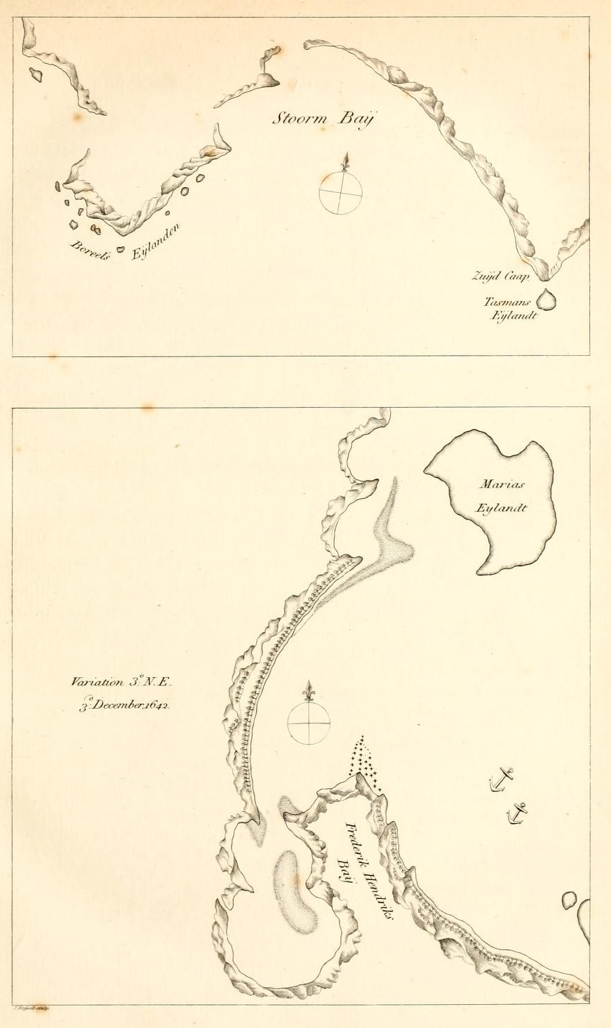
[page break]
[page] 71
1642.
December.
Van Diemen's Land
bushes. The country was all over furnished with trees which stood thin, so that one might pass through every where, and distinguish objects at a distance, without hindrance from bushes or underwood. Many of the trees were burnt deep in near the ground. Smokes also were observed rising in several places in the woods.
3d
The 3d, we went with our shallop to the SE part of this Bay, where we found water, but the land was low and the water saltish. In the afternoon, we went to a little Bay WSW from our ships; but it came to blow, and the surf was high. We however let our carpenter swim to the shore, where he set up a post, and left the Prince's flag flying upon it. This was nigh to four remarkable trees which stand in form of a crescent. When the carpenter had erected the post with the flag, he swam back to us through the surf, and we returned on board. In the evening, we observed 3° NE variation. We lay at anchor here in 43° S latitude, and longitude 167° 30′.*
4th
The 4th, in the morning, we got under sail, with a NW wind, and steered to the Northward as close as we could, that we might look for a watering place. In the evening we saw a round mountain about eight miles NNW from us. We kept
* Names are not given in the Journal to the Bays or Capes seen of this land, or to the Islands near it. It is probable they were afterwards assigned on making the charts. In the chart of the Bay where Tasman anchored is inserted the name Frederik Hendrik's Bay, but disposed in such manner as to cause a belief that it was applied only to the inner harbour, which the boats visited on December the 2d.In 1772 M.Marion anchored in the same Bay in which Tasman had anchored so many years before; and it appears in the short account published of his Voyage, that he considered it to be the Frederik Hendrik's Bay of Tasman. The late French charts however, apply the name solely to the inner port, which seems to have been the intention of the first discoverers; and to the anchorage of Abel Tasman and Marion, assign the name of Marion's Bay.
By some mistake in Valentyn, the ship's place on the 1st of December at noon, is given for the situation of Frederik Hendrik's Bay. The chart of Van Dieman's Land, likewise, in Valentyn, though the outline of coast is the same as in Tasman's chart, is marked differently in longitude, and not agreeing with the Journal.
[page] 72
1642.
December.
our course close to the wind NEastward. Several smokes of fires were seen along the coast all the day. Here I should give a description of the extent of the coast, and the Islands near it; but I hope to be excused, and refer for brevity's sake to the Map made of it and joined herewith.
5th.
Quit Van Diemen's Land.
The 5th, we kept our course as before, and lost sight of the land, the part last seen being the round mountain, which was then due West, six miles from us. We assembled the Council, and resolved to keep our course Eastward to longitude 195°. At noon, our latitude was by account 41° 34′ S. Longitude 169°.
11th.
The 11th, the variation was 7° NEasterly.
12 th.
The 12th, we had a high sea from the SW.
13th.
Other Land discovered.
The 13th, our latitude was 42° 10′ S. Longitude 188° 28′. Towards noon, we saw a large high land about 15 miles SSE from us. We steered towards it, but the wind was light and variable. In the evening, we had a breeze, and steered East.
14th.
Staten Land.*
The 14th, at noon, we were about two miles from the shore. Our latitude was 42° l0′S; longitude 189° 3′. This is a high double land. We could not get sight of the tops of the mountains for dark clouds. We sailed along the coast Northward, so close that we could see the waves break on the shore. We had soundings at two miles distance, 55 fathoms grey sand. In the evening and night it was calm, and a current set from the WNW which made us approach the shore, so we anchored with our stream anchor in 28 fathoms, muddy bottom,
15th.
The 15th, in the morning, having a light wind, we weighed and stood farther from shore, and then kept our course Northward. At noon our latitude was 41° 40′S; longitude 189° 49′. We did not perceive any people, or the smokes of fires upon the land: and we could see that near the sea-coast the land was barren.
*So was this discovery at first named; but afterwards, NEW ZEALAND.
[page break]
[page break]

[page] 73
1642.
December.
Staten Land.
16th.
The 16th, we had little wind. Latitude at noon 40° 58′ S. At sunset, we found variation 9° 23′ NEasterly. The Northern extremity of the land in sight bore EbN from us. We steered towards it NE and ENE. In the second watch, we had soundings at 60 fathoms, fine grey sand.
17th.
The 17th, at sunrise, we were about one mile from shore, and saw smoke rising in different places. At noon, latitude by account 40° 32′S; longitude 190° 47′. In the afternoon we sailed EbS, along a low land full of sand hills; having soundings at 30 fathoms depth, black sand. At sunset we anchored in 17 fathoms, near a sandy point of land, within which we saw a large open Bay, three or four miles wide. From this sandy point, a shoal or sand bank runs off a mile to the ESE, which lies under water, with six, seven, and eight feet depth: when you have passed this shoal, you can enter the Bay.* Variation here 9° NEasterly.
18th.
Moordenaar's Bay.
The 18th. In the morning we weighed anchor, and stood into the Bay; our shallop and a boat of the Zeehaan going in before us to look for good anchorage and a watering place. At sunset it was calm, and we cast anchor in 15 fathoms, good muddy ground. An hour after sunset, we saw several lights on the land, and four vessels coming from the shore towards us. Two of these were our own boats. The people in the other two called to us in a strong rough voice. What they said, we did not understand; however, we called to them again in place of an answer. They repeated their cries several times, but did not come nearer than a stone's throw: they sounded also an instrument which made a noise like a Moorish trumpet; and we answered by blowing our trumpet. This was done on
* In a view given in the Mannscript Journal of the coast at this part, a remark is inserted that this shoal or bank extends three miles Eastward and Southward from the sandy point. The Chart, however, agrees with what is said in the Journal, as above.
VOL. III. L
[page] 74
1642.
December.
Staten Land.
In Moordenaar's Bay.
both sides several times. When it grew dark, they left off, and went away. We kept good watch all night, with our guns ready.
19th.
The 19th, in the morning, a boat of the natives having 13 men in it, came near our ship; but not nearer than a stone's throw. They called to us several times, but their language had nothing in it like to the vocabulary of the Salomon Islands given to us by the General and Council at BATAVIA. These people, as well as we could judge, were of our own common stature, strong boned, and of a rough voice. Their colour is between brown and yellow; their hair black, which they tie up on the crown of the head, like to the Japanese, and wear a large white feather upright in it.* Their vessels were two narrow long canoes fastened together, upon which, boards were fixed to sit on. Their paddles were more than a fathom long, and were pointed at the end. Their clothing seemed to us to be of mats, or of cotton: but most of them went with their breast naked.
We showed them fish, linen, and knives, to invite them to come to us; but they would not, and at length rowed back to the land. In the meantime, the Officers of the Zeehaan came on board us, and we resolved to go nearer to the shore with our ships, as here is good anchorage, and the people seemed to be desirous of our friendship. Immediately after we had taken this resolution, we saw seven vessels coming from the shore. One of them in which were 17 men, came very quick, and turned round behind the Zeehaan. Another with 13 stout men came within half a stone's throw of our ship. They called out one to the other several times. We showed them, as before, white linen: but they lay still. The Master of the Zeehaan, Gerard Janszoon, who was on board of our ship, ordered his boat, in which were a quarter-master and six seamen, to go to his ship,
* This part of the New Zealander's dress is omitted in the drawing. In Valentyn it has been supplied on the authority of the narrative.
[page break]
[page break]

[page] 75
1642.
December.
Staten Land.
In Moordenaar's Bay.
to carry directions to the mates to keep on their guard, and that in case these people should come along side, not to allow too many of them to enter the ship at one time. When the Zeehaan's boat put off from our ship, the natives in the praws or canoes nearest to us, gave a loud call to those who were behind the Zeehaan, and made a signal with their paddles, the meaning of which we could not guess. But when the boat of the Zeehaan had gone quite clear from our ship, the canoes of the natives which were between our two ships made furiously towards her, and ran with their beaks violently against her, so as to make lier heel and take in water; and the foremost of these villains, with a blunt pointed pike, gave the quarter-master, Cornelius Joppe, a violent blow in his neck which made him fall overboard. The others then attacked the rest of our boat's crew with their paddles, and with short thick clubs (which we had in the beginning supposed to be clumsy parangs *) and overcame them. In this scuffle, three of the Zeehaan's men were killed, and one was mortally wounded. The quarter-master and two seamen swam for our ship, and we sent our boat which took them up alive. After the fight, these murderers took one of our dead people into their canoe: another of our dead men fell overboard and sunk. They let the boat go. Our ship and the Zeehaan fired at them with our muskets and guns, but we did not hit them, and they paddled away to the shore. We sent our boat to bring back the boat of the Zeehaan, wherein we found one of her men dead, and one mortally wounded.
After this, there could no friendly intercourse take place between us and the natives, nor could we hope to obtain water or refreshments here; so we weighed anchor and set sail. When we were under sail, twenty-two of their boats put off from the shore and advanced towards us. Eleven of them were full of people. When they were come within reach of our guns, we
* Parangs are knives used in some parts of the East Indies for cutting wood.
[page] 76
1642.
December.
Staten Land.
fired two shot at them, but without effect. The Zeehaan fired also, and hit a man in their foremost canoe, who was standing with a white flag in his hand, so that he fell down. We heard our grape shot clash against their canoes, but we know not what the effect was, except that it caused them suddenly to retreat towards the shore, where they lay still and did not come towards us again.
We named this Bay Moordcnaar's Bay, [i. e. Murderer's Bay. ]The partin which we anchored is in 40° 50′ S latitude, and in longitude 191° 30′. Variation there, 9° 30′ NEasterly. From Moordenaar's Bay we steered ENE; but during the night we sailed backward and forward, having soundings from26 to 15 fathoms.
This is lhe second Land discovered by us. We named it Staten Land in honour of the States General. It is possible that this land joins to the Staten Land; * but it is uncertain. It is a very fine country, and we hope it is part of the Unknown South Continent.
20th.
The 20th, in the morning, we saw land nearly all round us, so that we have sailed perhaps 30 miles into a Bay. We at first thought the place where we had anchored was an Island, and that we should find a clear passage [Eastward] to the Great South Sea; but to our great disappointment we find it otherwise. The wind being from the Westward, we did all in our power to turn to windward to get back the way we had come. At noon we were in latitude 40° 5l' S. Longitude 192° 55′. In
* Meaning the Staten land to the East of the Tierra del Fuego, discovered and so named by Schouten and Le Maire. The supposition that both Schouten and Le Maire's discovery and his own might form part of one and the same great Continent, led Tasman to apply the name on the present occasion; and singularly enough, in the last year in which it could have been allowable: for in the year which next followed, the Expedition of Hendrik Brower to chili, deprived Schouten and Le Maire's staten Land of the honour of being any longer conjectured to be Continental Land. And Tasman's staten Land being thereby proved a separate Land from Schonten and Le Maire's discovery, its name was, not long afterwards, changed for that of NEW ZEALAND, which name it still retains.
[page] 77
1642.
December.
Staten Land.
the afternoon it was calm, and the current ran strong into the Bay. The land all around seems to be good fine land. The sea coast is low, but the land within is high enough. We found a muddy anchoring ground, at 60, 50, and to 15 fathoms depth, about 1 or 2 miles from shore. We had light winds all the afternoon.
21st.
The 21st, in the second watch of the night, a breeze came from the West, and we sailed Northward. We found the coast of the Northern land to extend towards the NW. In the morning, it began to blow fresh. After breakfast we put about, and stood towards the South coast. Towards evening, we ran for shelter within a small Island which we brought to bear NNW of us, and then cast anchor in 33 fathoms, the bottom sand and shells. We had other Islands and cliffs near us. Our latitude here was 40° 50′, and longitude 192° 37′.* It blew so hard in the night that we let go another anchor and got down the topmasts, as did the Zeehaan.
22d. 23d.
The 22d and 23d, the gale continued strong from the NW, with dark foggy weather. The Zeehaan was almost forced from her anchors.
24 th.
The 24th, in the morning, it was calm. The Officers of the Zeehaan came on board our ship, and proposed that if the wind and weather would permit, we should examine if there is any passage through this Bay, as the flood tide was observed to come from the SE.†
25th.
The 25th, the weather looked still very dark, and we remained at anchor.
26th.
The 26th, in the morning, the wind came from ENE. We got under sail, and held our course North, and afterwards NNW, intending to sail round this land Northward.
* The situation here mentioned in the Journal is a quarter of a degree more Northerly than the anchoring place marked on the chart.
† The unfavourble appearance of the weather seems to have prevented Tasman from making the proposed examination.
[page] 78
1642.
December.
Staten Land.
27 th.
The 27th, we had a strong breeze from SW. At noon, our latitude was 38° 38′ S. Longitude 190° 15′. After noon we steered NE [to get in with the land]. Variation 8° 20′ NE.
28th.
The 28th, at noon, we saw a high mountain EbN from us, which at first we took to be an Island, but we found it was a part of the main land, and that the coast here extends as much as I could observe North and South. This mountain is in 38° S latitude. Our latitude at noon, by account, was 38° 2′. Longitude 192°. 23′. At five miles from the shore we had soundings in 50 fathoms, fine sand mixed with clay. In the night it blew hard.
29th.
The 29th, we had a fresh gale. Latitude at noon 37° 17′S.
30th.
The 30th, the weather became moderate, wind WNW. At noon our latitude was 37° S. Longitude 191° 55′. We sailed NE, and towards evening saw the land again, bearing NE and NNE; we therefore steered more to the North.
31st.
The 31st, at noon, found our latitude 36° 45′S: longitude 191° 46′. The coast here lies SE and NW. This land is in some places high; and in some full of sand hills. In the evening we were three miles from shore. Had soundings in the night at 80 fathoms.
1643. January.
January 1st, 1643. This is an even coast, without shoals or banks, but there is a great, surf on the shore. Latitude at noon 36° 12' S.
2d,3d
The 2d, and 3d, running Northward along the coast.
4th.
The 4th. This morning we were near a Cape of land, and had an Island NWbN from us. We hoisted the white flag for the Officers of the Zeehaan to come on board, and we resolved to stand for the Island to look for fresh water and greens. We find a strong current setting, and much sea from the NE, from which we hope to find a clear passage Eastward. In the evening we were near the Island, but could not observe that any thing we wanted might be got here.
5th.
The 5th, in the morning, we had little wind and a calm sea. About noon, we sent Francis Jacobsz in our shallop, and the
[page break]
[page break]

[page] 79
1643.
January.
Drie Koningen Island.
supercargo, Mr. Gillemans, in the Zeehaan′S boat to the Island, to try if fresh water could be got. In the evening, they returned, and reported that they had been at a safe small Bay where fresh water came in abundance from a high mountain; but that there was a great surf on the shore, which would, make watering there troublesome and dangerous. They rowed farther round about this Island to look if there was any more convenient place. Upon the highest mountain of the Island, they saw 35 persons who were very tall, and had staves or clubs. These people called to them in a strong rough voice. When they walked, they took very large strides. On other parts of the Island, a few people were seen here and there, which with those already mentioned, were thought to be all, or nearly all the inhabitants of the Island. Our people saw no trees, nor did they observe any cultivated land, except that near the fresh water there were some square plots of ground, green, and very pleasant; but of what kind the greens were, they could not distinguish. Two canoes were drawn up on the shore.
In the evening, we anchored in 40 fathoms, good ground, a musket shot distant from the Island. [On the North side.]
6th.
The 6th, in the morning, we put water casks in the two boats, and sent them to the shore. As they rowed towards the land, they saw tall men standing in different places, with long staves like pikes in their hands, who called to our people. There was much surf at the watering place, which made landing difficult; and between a point of the Island and another very high cliff or little Island, the current ran so strong against the boats that they could scarcely stem it: for which reasons the Officers held counsel together, and not being willing to expose the boats and the people, they returned to the ships. Before we saw them coming back, we had fired a gun and hoisted a flag as a signal for them to return. This Island we named Drie Koningen Eyland, i. e. Three Kings Island; [on account of this being the day of the Epiphany.] It is in latitude 34° 25′ S, and longitude 190° 40′.
[page] 80
1643.
January.
Sail from Staten Land.
We called the Officers of the Zeehaan on board, and it was resolved in Council, to sail Eastward to longitude 220°, and then to steer North; and afterwards to get sight of the Cocos and Hoorne Islands. In the afternoon, we had the wind ESE, and steered NE. At sunset, Drie Koningen Island bore SSW distant six or seven miles; the cliffs and the Island bearing NE and SW one from the other.*
The 7th, 8th, and 9th,† steered to the NE, with light East and ESE winds. A swell from the SE.
10th.
The 10th, found our latitude at noon 31° 28′S. Longitude 192° 43′. The variation 10° 30' NEasterly.
[From the 10th to the 19th, the winds were variable; the courses sailed were towards the NE.]
19th.
Pylstaart Island.
January the 19th, at noon, our latitude was 22° 49' S. Longitude 203° 27′. About two o'clock this afternoon, we discovered land bearing EbN about eight miles from us. We could not get near it, the wind being from the SE and blowing fresh. It is a high Island, not more than two or three miles in circumference, and in the situation it was from us, it resembled the breasts of a woman. It is in latitude 22° 55' S,‡ and longitude 204° 15′. We called it Pylstaart Eylandt, [Tropic Bird Island ] as we saw many of those birds near it. § The variation there was 7° 30′.
20th.
The 20th. At sunrise, the Island we saw yesterday was still in sight, SSW from us, six miles. At noon, found we were in latitude 21° 50′S. About one hour past noon, we saw other land bearing East from us, distant eight miles. We made towards it, and at night took in sail and lay to.
* This was not an observed, but an estimated bearing. By the cliffs (Clippen) are meant the small isles and rocks SW estward of Drie Koningen Island.
† The Journal contains no remark of land being in sight on any of these three days.
‡ This latitude does not correspond with the noon latitude, it being evident the Island is more Northerly than the ship′S situation at noon. Late observations give the latitude of this Island 22° 23' 30" S.
§ Pyl-staert or Pyl-staart signifies Arrow-tailed, and is the name by which the Hollanders distinguish the bird we call Tropic Bird.
[page break]
[page break]

[page] 81
1643
January 21st.
Amsterdam Island.
The 21st, in the first of the morning, it was calm. An Island bore from us EbS, distant five miles. Another Island lay to the North of it. We sailed to the NW part of the Northern Island, where we cast anchor in 25 fathoms, coral bottom. Here we lay in 21° 20′ S latitude, and in longitude 205° 29′. These two Islands lie about SE and NW one from the other, and one mile and a half apart. The SE Island is the highest: the Northern Island is like Holland, and we named it Amsterdam, for we found plenty of refreshments here. The Southerly Island we named Middleburgh* At noon, three men [natives] came in a small boat or canoe near our ship. They were of a brown colour, and naked except a poor covering round the waist. They were taller than our common stature, and two of them had Ions thick hair: the other had his hair cut very short. They called out loud to us several times; and we did so to them. We showed them some white linen, and threw a piece about three yards long into the water to them. They came towards it with their canoe, but it began to sink, and was already deep in the water when one of them jumped out of the canoe and dived after it. He was a long time under water, and at length came up with the linen. He put it several times upon his head as a sign of thankfulness. They then came a little nearer to the ship, and we tied two spike nails, a small Chinese looking-glass, and a string of beads, to a piece of wood, and put it overboard, which they took up, and in return reached to us with a long stick one of their fish-hooks and a small fishing-line. The fish-hook was made of shell, and like a small anchovy. They laid the looking-glass and the beads several times upon their heads, and one of them hung the spike nails round his neck. But as the shutter was before the looking-glass so that they could not
* The Northern, which is the largest of the two Islands, is called by the natives Tonga-tabu: the other Eooa. Tonga-tabu is the principal Island of the group which Captain Cook named the Friendly Islands.
VOL. III. M
[page] 82
1643.
January.
Amsterdam Island.
look in it, we reached them another, which they looked in and laid on their heads. We showed them an old cocoa-nut and a fowl, and asked them from our Vocabulary for hogs, and fresh water; but we did not make them understand us. At last, they left us and went on shore, and it seemed to us as if they went for the purpose of fetching something for us. In the afternoon, we saw many people running along the shore with white flags, which we took to be meant for signs of peace, and we hoisted a white flag at our stern; whereupon four strong men in a small canoe carrying a white flag, put off from the shore and came on board us. The men were painted black from the middle to the thighs, and they had coverings of leaves round their necks. They delivered to us some cloth made of the bark of a tree; and the white flag they fixed on the stem of our boat. We judged from their gift, and by their canoe being better than the common ones, that they came from the King or Chief of the Country; and we gave them in return, a looking-glass, a knife, a piece of linen, and two spikes. We filled a wine-glass with wine, and drank it, to show them that it was nothing hurtful, and then filled the glass again and gave it them: but they threw out the wine, and took the glass with them on shore. In a short time after, a great many canoes came to the ships, bringing cocoa-nuts, for which we gave old nails in exchange, at the rate of three or four cocoa-nuts for a double spike. Besides those who came in the canoes, several of the natives swam from the shore, bringing things to exchange. Presently, a grave old man came on board of us, to whom the other Islanders showed much respect, so that he seemed to be their Chief. We conducted him to our Cabin. He paid us his respects, by bowing his head upon our feet; and we did him honour our way. We showed him a cup of fresh water, and he made signs that there was fresh water on shore. We made him a present of a piece of linen and several other things. This afternoon we detected one
[page] 83
1643.
January.
Amsterdam Island.
of the natives in stealing a pistol and a pair of gloves belonging to the Master of our ship. We took the things from him without anger.
When it was near sunset, about 20 canoes came from the shore and took stations near our ship in a regular order. The people in them were very loud, and called out several times, Woo, Woo, Woo! whereupon all the natives who were in our ship sat down, and one of the canoes came on board, bringing a present from their King, of a fine large hog, and a great many cocoa-nuts and yams. The bearer of this was one of the four men who had first come to us with the white flag and the cloth. We returned by him a plate and some brass wire. We continued to make exchanges for provisions, until it began to grow dark, when all the natives went ashore except one, who staid and slept on board of us.
22d.
The 22d, in the morning, many canoes came off to us with cocoa-nuts, yams, bananas, plantains, hogs, and fowls, which they exchanged for nails, beads, and linen. Several women also came on board, both old and young. The elder women had the little finger cut off from both hands; but the young. women had not. The meaning of this we could not guess. The person who yesterday brought the presents, came this morning with two hogs; and we in return gave him a handsome knife and eight spike nails. We likewise gave this old man a satin habit, a hat, and a shirt, which we put on him. We carried some of the natives below to see our ship, and fired one of our great guns, which frightened them a good deal, but seeing that nobody was hurt, they were soon easy again.
About noon, a large boat with a sail, such as is drawn in Le Maire and Schouten′S Voyage, came to us. They made us a present of their cloth and some provisions, for which we made returns, and caused our music to be played, which they admired.
In the mean time, we sent our boat and one of the Zeehaan′S
M 2
[page] 84
1643.
January.
Amsterdam Island.
boats to the shore with water casks, they being armed with muskets, and our Master and Mr. Gillemans going in them. Some of the inhabitants also went from the ship with our people to shew them where the fresh water was. They rowed a good way towards the NE coast of this land, and arrived at last at a place where there were three small wells; but with so little water in them that they were obliged to take it up with cocoa-nut shells; and what they took was of a bad colour. The natives who conducted our men, led them farther into the country to a pleasant valley, where they were seated upon fine mats, and fresh water in cocoa-nut shells brought to them. In the evening, the boats returned on board, bringing a live hog: but from the account they gave, we found we could not water the ships here. We got by exchanges in the course of this day, near 40 hogs and 70 fowls, at the rate of a spike nail and a yard of old sail-cloth for a hog, and a double middle nail for a fowl; yams, cocoa-nuts, and fruits we bought for coral or beads. These people have no idea of tobacco, or of smoking. We saw no arms among them, so that here was altogether peace and friendship. The women wear a covering of mat-work that reaches from the middle to the knees: the rest of their body is naked. They cut their hair shorter than that of the men.
The tide here runs SW and NE; and by our account we make it high water with a SW moon: the current is not strong: the rise and fall of the tide is seven or eight feet.
23d.
The 23d. This morning, myself and the Skipper of our ship, Gerard Janszoon, went on shore with the shallop and two boats to dig for fresh water. We made the Chief understand that the wells ought to be made larger, and he directly set his people to work to do it for us; and in the mean while, he went with us to the valley, and ordered mats to be spread on the ground, and when we were seated, cocoa-nuts and fresh fish and several fruits were brought to us. He behaved to us with great friendship,
[page break]
[page break]

[page] 85
1643.
January.
Amsterdam Island.
ship, and enquired of us whence we came, and where we intended to go. We told him we had been more than a hundred days at sea, at which he and the natives were much astonished. We explained to them that we came to their country for water and provisions; and they answered us that we should have as much as we could wish for. We filled to day nine casks with water, and the Chief made us a present of four live hogs, a good many fowls, with cocoa-nuts and sugar canes. We presented him with two yards of cloth, six large spikes, and six strings of coral. I ordered a white flag to be brought, and we went with it to three of their Chiefs, to whom we explained that we wished it to be set up in that valley, and that it might remain there as a sign of peace between us: at which they were much pleased, and the flag was fixed there.
The anchoring ground where the ships lay was steep and rocky; and about noon this day, whilst I was on shore, the Heemskerk was driven off the bank by the strengh of the trade wind, without being able to help it, and she drifted out to sea. There were but few people on board, and it was midnight before they got the anchor quite up and secured.
We obtained by exchanges with the inhabitants this day, 100 hogs, 150 fowls, and a large quantity of yams, and other fruits. As I could not get to my ship, I was obliged to pass the night on board the Zeehaan.
24th.
The 24th, in the morning, the Heesmkerk was four miles to leeward of the Island. The Zeehaan therefore was got under sail and we went out and joined her. When I got on board the Heemskerk, we held a Council, and there being little prospect that we should be able to fetch up to the Island again, as the trade wind was strong from the SE, we resolved to proceed on our voyage, and to stop at some other Island, if we should meet with any.
The place where we anchored at Amsterdam we called Van Diemen′S
[page] 86
1643.
January.
Diemen′S Road; and the Bay where our boats went to fetch water we named Maria′S Bay; in honour of our Governor General; and his Lady. From our anchoring place at Amsterdam, two high but small Islands, about one mile and a half each in circumferenee, bore NbW, distant seven or eight miles.
Other Islands discovered.
At Amamocka, or Rotterdam Island.
We directed our course NE, and about three in the afternoon, we saw a low and pretty large Island, distant four or five miles ENE from us. A short time afterwards, we saw three small Islands Eastward, and two others to the SE from us. They are all low land. We steered ENE for the largest Island, and anchored by the West side of it in 12 fathoms, shelly bottom, about a musket shot distance from land. NWbN from us, distant eight or nine miles, we saw two high Islands; and to the North and NEastward we saw seven small Islands, distant from us about three or four miles. Most of these Islands have reefs of coral rock round about them: and the bottom also is rocky and steep, so that one must anchor near to the shore. The variation is here 7° North Easterly.
25th.
The 25th, in the morning, several canoes came on board of us with cocoa-nuts, yams, and plantains, to exchange for nails, of which they were very desirous. It seems that but a few people live on this Island. Our chief pilot and the Master went with the shallop and both the boats for fresh water, one of the inhabitants going with them to show them where it was. We gave small presents to some of the natives, that they might know we did not desire to take their water without paying them for it. About two hours before sunset, the Master and pilot returned on board. They reported that they found on shore 60 or 70 persons sitting down, whom they believed to be all the men on this Island: that they had no arms, and seemed a good peaceable people. They saw also many women and children, and were shewn a good path which led landwards two-thirds of a mile, to a piece of fresh water about a quarter of a mile in circumference,
[page] 87
1643.
January.
Amamocka or Rotterdam Island.
circumference, and which is a fathom and a half or two fathoms higher than the level of the sea. They walked round by the edge of this lake, and found that it lay within a musket shot of the sea on the North side of the Island, where there was a good sandy Bay, and smooth water for landing and for loading the boats. In the front of this Bay was a coral reef, in which there was an opening on the West side. At low water one can row along the shore to the calm water, but the tide must be risen 1 1/2 or 2 feet before one can get to the sandy strand.
As this was at the North side of the Island, and our ships lay at the West side, the boats had to row along the shore a full mile to come at the Bay near the fresh water. About three hours after sunset, our boats returned on board with water. The tide rises and falls here about eight feet. In the lake of fresh water were a good many wild duck, which were not at all shy. The inhabitants came to us with fruits and a few hogs. They are a thievish people, and steal every thing they can get at. Their clothing and manners are the same as those of the people of Amsterdam Island, except that the men had not so long and thick hair. The women seemed to be as strong in their bodies and limbs as the men. We named this Island Rotterdam. The natives called it Amamocka.! It lies in latitute 20° 15′ S, longitude 206° 19′ † The variation here is 6° 20′ NE.
* The name by which the natives call this Island, is not given in the Manuscript Journal in the regular course of the narrative; but in the drawings. Two of the drawings shew the name differently written. Tabula XXI. of the Manuscript, is a plan and representation of the Island Amamocka, with small Islands near it of the names Amo, Amoa, Amango, and Amatafoa. Tabula XXI. is a representation of the inhabitants of Anamocka. The navigators of our own time have understood the native pronunciation of the name to be Anamocka; but the number of names with the same commencement in Tab. XXI. have much appearance of some reference to one common meaning, and favours the probability of Amamocka being the right native name.
† In Tasman′S Chart it is laid down a few miles mors Eastward.
[page] 88
1643.
January.
Amamocka.
We continued at anchor taking on board fresh water, and making exchanges for provisions: and God be thanked, we were here well refreshed, and provided with water: but the eyes of an Argus are scarcely sufficient to guard against the thieving of the inhabitants.
31st.
On the 31st, at noon, I went on shore with the chief pilot, the Skipper of our ship, and Mr. Gillemans, the merchant of the Zeehaan, to take our leave, and to make some more exchanges. When we landed, a great many of the natives assembled about us. We asked two of the principal among them to lead us to the Chief of the Island; and they conducted us by narrow paths, which were very dirty from much rain having fallen in the two last days, to the South side of the Island, where many cocoa-nut trees were regularly planted. From here they took us to the East side of the Island where six large vessels with masts were lying. They then led us to a pool of water which was about a mile in circumference; but we were not yet come to the Aigy or Latoun, as they call their Chief. When we had rested, we again asked where the Aigy was; and they pointed to the other side of the pool of water: but the day being far advanced, we returned by another way to our boats. In our walk, we saw several pieces of cultivated ground, or gardens, where the beds were regularly laid out into squares, and planted with different plants and fruits; bananas and other trees placed in strait lines, which made a pleasant show, and spread round about a very agreeable and fine odour: so that among these people who have the form of the human species but no human manners, you may see traces of reason and understanding. They know nothing about Religion or Divine Worship: they have no idols, relicks, or priests: but they have nevertheless superstitions; for 1 saw a man take up a water snake which was near his boat, and he put it respectfully upon his head, and then again into the water. They kill no flies, though they are very
2
[page] 89
1643.
numerous and plague them extremely. Our steersman accidentally killed a fly in the presence of one of the principal people, who could not help shewing anger at it. The people of this Island have no King or Chief, and are without government; nevertheless they punished a man who was detected in stealing from us, by beating him with an old cocoa-nut on the back till the nut broke.
February.
February the 1st. This morning we weighed our anchors and sailed towards the NNW.
An Island.
The 2d, at noon, we were in latitude 19°20′ S; longitude 205°55′. In the afternoon, we discovered an Island of a tolerable height, bearing NEbE from us about seven miles distant.* We had the wind from East, a weak breeze. Our course was North.
On the 4th, being under 17° S latitude, it was resolved in Council to steer Westward, and to keep a sharp look-out that we might not pass the Cocos and Verraders Islands. †
The 5th, we held our course Westward with a light wind from the ESE, and kept a look-out for Cocos and Verraders Islands. Latitude at noon 16° 30′; longitude 203° 12′. After three glasses of the dog watch had run out, we saw land, and immediately changed our course Southward till seven glasses were out, and then turned Northward.
6th. Prins Willem′S Islands, And Heemskerk′S Shoals.
The 6th, in the morning, we saw the land again, which we found to be three small Islands, with many sand banks and shoals round them. A large reef was to the Westward, which extended to the South, and gave us some apprehension. We sailed Southward close to the wind, which was from ESE. This reef was eight or nine miles in length; and right before us we saw breakers, which we did not dare attempt to pass. We could not clear this reef, neither could we clear a reef which
* In Tasman′S chart, this Island is laid down due North from the anchoring place at Amamocka, and in latitude 18° 50′ S.
† At the time of altering the course to the West, Tasman was a degree of longitude to the Westward of Cocos and Verraders Islands.
VOL. III. N
[page] 90
1643.
February.
Prins Willem′S Islands.
7 th.
was to the Northward. We observed a small channel about twice the length of a ship wide, where there was no surf; and as we had no other chance for safety, we steered for it, and passed through the [opening in the] reef, having four fathoms depth, being all the time under a great deal of anxiety. You meet every where hereabouts with shoals, and there are here likewise about 18 or 19 Islands which you cannot coast on account of the reefs. When we were clear within the opening, we wished much to anchor near one of the Islands, but could not find anchorage for the many shoals and reefs. At noon, our latitude by account was 17° 9′. Longitude 201° 35′. After noon, we directed our course Northward to try to get out of these difficulties before night. There were many sands to the North, which we could scarcely keep clear of; but at last we found a passage between the reefs. It was a great disappointment to us that we could not find anchorage among these Islands. In the evening we saw three hills, which we took to be so many Islands. Part of the first watch of the night we ran back to avoid sands. After five glasses [i. e. five half hours] we put about Northward intending to run that way for the rest of the night. The wind was fresh from NE, and blew strong with rain. Early in the morning we came close upon an Island, and therefore we turned again Southward till day-break. We then saw the Island which yesterday evening bore NbW, and again put about to the Northward. The wind was NE and stormy; and we went with shortened sail to the NW. At noon we conjectured our latitude to be 16° S, and longitude 200° 48′.*
8th.
The 8th. This day we held Council amongst ourselves in the Heemskerk, it being too stormy for our friends of the Zeehaan to come on board; and we came to a resolution to steer a
* The account of this day′S navigation does not well agree with the track in the Chart. The Journal assigns no name to these Islands. In the Chart the whole groupe is named Prins Willem′S Eylanden (i. e. Prince William′S Islands); and the reefs and shoals are named Heemskerk′S Droochten (i. e. Heemskerk′S Shoals).
[page] 91
1643.
February.
Northerly course to 5° or to 4° of S latitude, that we might keep clear of the East coast of Nova Guinea, the present time of the year being the season when the North and South trade winds meet one another, which must be the cause of a great deal of rain and bad weather. In the large map of the South Sea, there are marked some Islands in the same latitude as the Islands we have met with, but differing in longitude above 200 miles from our accounts. However, as our voyage is very long, and we have sailed much East, and much West, it is possible there might be such a difference. The Islands by which we were so much encompassed on the 6th, are about 18 or 20 in number, perhaps more, as we could not exactly number them in the dark weather we had.
[From the time Tasman left the Prins willem′S Islands to March the 21st inclusive, no land was seen, nor does the Journal contain any occurrence particularly deserving notice, except what relates to the track sailed and the weather. For that interval therefore, the winds and the ship′S place on every day at noon, are here set down tabular-wise, as being best adapted for giving a clear view of the navigation. Tasman made the longitude of Amamocka 206° 19′ E. The longitudes therefore set down in this account of his track, if sub-tracted from 206° 19′, will give longitude by his Reckoning, West of Amamocka. ]
| Latitude at noon. | Longitude. | |
| Our latitude on the 8th at noon, was, | 15o. 29′. S. | 199°. 31′. |
| The. 9th. Wind North and tempestuous with rain | 15. 29. | 98. 8. |
| 10th. Dark rainy weather. We have been five days without seeing sun, moon, or stars | 15. 19. | 197. 20. |
| 11th. Gale still from the North | 15. 5. | 196. 5 |
| 12th. Had an observation at noon for the latitude | 15. 3. | 195 50 |
| In the night we had sudden shifts of wind, with such heavy showers that the waters seemed to be poured down from Heaven, and much thunder and lightning. |
N 2
[page] 92
| Latitude at noon. | Longitude. | |
| The 13th. Wind Northerly with rain | 15°. 38′. S. | 194o. 4′. |
| 14th. Wind NW, with dark wet weather | 16. 20. | 193. 35. |
| 15th. the same, a weak breeze | 16. 30. | 193. 35. |
| 16th. Calm. | ||
| 17th. Calm, rain | 16. 22. | 193. 35. |
| 18th. Calm with showers. | ||
| 19th. A light SE wind, with rain | 15. 12. | 193. 35. |
| 20th. Wind variable | 13. 45. | 193. 35. |
| 21 st. Wind Westerly with rain | 13. 21. | 193. 35. |
| 22d variable with heavy rain | 13. 5. | 192. 57. |
| 23d. West. Stormy with rain | 12. 10. | 192. 57. |
| 24th. | 11. 2. | 192. 58. |
| 25th. | 10. 31. | 193. 0. |
| 26th. Wind from NW; still blowing hard | 9. 48. | 193. 43. |
| 27th. | 9. 0. | 194. 32. |
| 28th. A Northerly wind with rain | 8. 48. | 194. 2. |
| March the 1st. A light North wind | 9. 5. | 193. 21. |
| 2d. Wind and weather variable | 9. 11. | 192. 46. |
| Observed the Variation 10 NEasterly. | ||
| 3d. Wind variable with much rain | 9. 11. | 192. 14. |
| 4th | 8. 55. | 191. 57. |
| 5th. | 8. 32. | 191. 42. |
| 6th. Sudden squalls and calms | 8. 8. | 191. 42. |
| 7th. Westerly with gloomy weather | 8. 17. | 191. 1. |
| 8th. The same | 7. 46. | 190. 47. |
| 9th. Wind NW, with rain | 8. 33. | 190. 1. |
| 10th. NNW, and rain | 9. 0. | 189. 33. |
| 10th. NNE | 9. 12. | 188. 29. |
| 12th. Northerly and tempestuous | 8. 48. | 187. 29. |
| 13th. Variable. Dark weather | 8. 48. | 186. 48. |
| 14th. SSE. Dry weather | 10. 12. | 186. 14. |
| This day we observed the latitude 10° 12′ S, which is the only observation we have had in |
CRAP. 4. 1643. February.
March.
[page] 93
| Latitude at noon. | Longitude. | |
| the last 12 days. We find we are not so far North by 1° 40′, as we had reckoned. Variation 8° 45′ NE. | ||
| 15th. Wind SE. Fair weather | 9°. 53′. S. | 185′. 40′. |
| 16th. | 8. 46. | 184. 51. |
| 17th. East, light | 8. 7. | 184. 11. |
| 18th. | 7. 40. | 183. 33. |
| 19th. Clear sky | 6. 25. | 182. 27. |
| 20th. ESE. Variation 9° NE | 5. 15. | 181. 16. |
| 21st. Wind from between East and NE. Observed | 5. 25. | 180. 20. |
CHAP. 4. 1643. March.
22d.
Island Onthona Java.
The 22d. Had a continuance of fine weather. The breeze light from the East and NE, with smooth water. We kept our course West, and at noon we saw land strait before us, distant about four miles; our latitude by account was 5° 2′ S. Longitude 178° 32′. We steered WbN and afterwards NW to go North of the land. In the evening, we sailed near to and along the North part of the land, which we found to be many very small Islands, about twenty. The largest of them is not more than two miles long, and they all lay within one reef. A reef runs off NW, upon which are three cocoa-nut trees, by which it may easily be known again. These are the Islands which are set down in the Map by Jacob Le Maire, about 90 miles distant from the coast of Nova Guinea. We named them Onthona Java for the great resemblance they have with it. In the evening we saw more land to the NNW; we therefore kept by the wind to the NNE in the night, with the foresail up.
23d.
The 23d, when it was day, we set sail and steered West. The Islands we saw yesterday evening bore South, about three miles distant. At noon, we were in latitude by account 4° 31' S, and longitude 177° 18′. At night we lay to, for fear of coming on the Islands named Marken.
[page] 94
1643.
March.
24th.
Marquen Islands.
The 24th. In the morning we made sail again, and steered West. About noon, we saw land right before us, very low, and appearing like two Islands, SE and NW one from the other. The most Northerly appears like Marken which Jacob Le Maire has described. At noon, we were in latitude 4° 55′ S, by which we find a current sets Southward. Our longitude, 175° 30′. In the evening we steered to pass to the Northward of these Islands. In the night we floated with a calm sea which set us towards them.
25th
The 25th. In the morning watch before it was day-light, we heard the surf beating against the shore. It was still calm, and we got our boats out to tow, to keep us from the reefs; but the current and swell carried us towards them, and we could not find anchorage. About nine o'clock in the forenoon, a canoe with seven men in it came from the land to us. They brought about twenty cocoa-nuts of a wild kind and not very good, for which we gave them three strings of coral and some nails. These people were naked, except a piece of cloth which seemed to be of cotton round their waist. They were blacker than the inhabitants of the Islands we had been at, and not so civil or friendly in their behaviour. Some of them had their hair cut short, and others had it bound up like those villains at Moordenaar′S Bay. One man had two feathers on the crown of his head, like two horns: another had rings through his nose, but what the rings were made of we could not distinguish. They did not set much value on the things we gave them. They were armed with bows and arrows. A breeze sprung up from the South, which happily carried us from the reef; and the canoe returned to the shore. There are 15 or 16 Islands in this groupe. The largest is about one mile long; the rest look almost like houses, and they lay all together within one reef. This reef towards the NW extends about a gun-shot beyond the Islands. At the NW part, is a small wood or cluster of trees growing on
3
[page] 95
1643.
March.
land that is level with the surface of the sea; and two miles thence farther to the NW, is a fragment or small clump*, like a cape of land. The reef extends still farther NWestward half a mile.
At noon we were in latitude by account 4° 34′ S, and longitude 175° 10′. We sailed on towards the West and NW.
26th.
The 26th. The latitude observed at noon was 4° 33′ S, by which we found that a current had set us Southward, and therefore we steered NW. Longitude 174° 30′. Variation 9° 3o' NEasterly.
27th.
The 27th. At noon our latitude was 4° l′. Longitude 173° 36′. We altered our course more to the West.
28th.
Groene Island.
The 28th. We had a weak breeze from East with fine weather and a smooth sea. Towards noon we saw land strait before us. At noon we found we were in latitude 4° 11′ S; longitude 172° 32′. The land was then about four miles distant. This Island is situated in latitude 4° 50′ S,† and longitude 172° 16′; and is 46 miles West and WbN from Marken. At night we floated in a calm sea.
29th.
The 29th, in the morning, we found the current had set us towards the Islands. At noon we were in latitude 4° 20′, and longitude 172° 17′. In the middle of the afternoon, two small boats came to us from the shore: they had two wings [outriggers]; in one were six, in the other three persons. When they came within a ship′S length of us, a man sitting in one of the canoes broke an arrow in the middle, and put one half in his hair, which we supposed he meant as a token of friendship. These people were naked, their bodies quite black; they had curled hair, but not so woolly as the hair of the Caffres; and their noses were not so flat. They had bracelets apparently made of bones;
* Klyn brokje.
† This is a disagreement from the latitude just before given of the ship at noon, for which no cause appears.
[page] 96
1643.
March.
some had their faces painted, and wore bands made of the bark of a tree round their foreheads. We spoke to them from our Vocabulary of the Nova Guinea language, but they did not understand any thing we said except the word Lamas, which signifies cocoa-nuts. They brought nothing with them but their bows and arrows. We gave them some beads and nails. Towards evening alight breeze from the NE drove us towards the Islands, and kept us employed during the first part of the night in towing the ships. By the end of the second night watch, we had past clear.
These are what Le Maire has named Groene Islands. There are five of them; to wit, two large Islands, and three small, which are on the West side.* They were so named on account of their being green and pleasant. We saw to the WSW another large Island, and two or three very small Islands; and also to the Westward, very high land, which seemed to be of an extensive coast. Variation 9° NEasterly.
30th.
Island St. Jan.
The 30th. A light breeze from the NE. Observed a current setting us Southward. At noon we found the latitude 4° 25′ longitude 172°. In the evening, St. Jail′S Island bore NW, about six miles distant.
31st.
The 31st, very light wind East. We held our course West.
* The Groene Islands are level land and near to each other, so that when seen from a distance, in many directions they appear as one Island. In Captain Carteret′S Voyage (A. D. 1767) they are deferibed as a single Island, and named Sir Charles Hardy′S Island. It is to be obferved that Captain Carteret saw and passed them in the night. Tasman, however, towards noon saw land, which at noon he calls an Island, and afterwards deferibes to be a groupe of five Islands. Tasman has given a view of the Groene Islands, which is copied in Valentyn: but Valentyn′S engraver has embellifhed this, and other of the drawings, with figures of the two ships, and has made this addition in a very uninformed manner; for at the Groene Islands he has represented the ships lying at anchor; and in some other plates they appear sailing in the direction opposite to the track.
[page break]
[page break]

[page] 97
1643.
April.
Land supposed part of New Guinea.
April the 1st, we were near the East part of Nova Guinea*, which the Spaniards call Cabo Santa Maria. At noon, found we Avere in latitude 4° 30′ S; longitude 171° 2′.
2d.
Ant. Kaan′S Island.
Cape Sta. Maria.
The 2d, we had light winds and calms. We endeavoured to sail along the coast which here lies NW and SE. About 10 miles distant from St. Jan′S is another Island, which we named Anthony Kaan′S Island. It bears due North from the Cape Santa Maria. At noon we found we were in latitude 4° 9′, and our longitude was 170° 41′. Cape Santa Maria then bore South; accordingly the longitude of the said Cape is 170° 4l′. In the night we had a land wind with which we held on our course NWestward.
3d.
The 3d, in the forenoon, we saw a veffel coming towards us from the land: she was curved at each end, and was full of people. They did not venture within reach of gun-shot, and after a little time, went back to the shore. Latitude by account at noon 3° 42′ S. Longitude 170° 20′. This seems to be a very fine land; but we could find no anchorage. In the night we had lightning and rain, and the wind variable.
4th.
Gerrit Denys Island.
The 4th, we sailed along the coast, which extends NWbW with a great many Bays. We passed an Island which lies NW 12 miles from Anthony Kaan′S Island. We called it Gerrit Denys Island. At noon, we reckoned our latitude 3° 22′ S. Longitude 169° 50′. In the night had a land wind, with thunder, lightning and rain.
5th.
Vischer′S Island.
The 5th, at noon, our latitude by account was 3° S. Longitude 169o 17′. We were near an Island that is about 10 miles distant to the WNW from Gerrit Denys Island. Some boats which we supposed to be fishing boats were lying close under this Island, and therefore we named it Vischer′S Island. About
* The land at present named New Ireland was then believed to join, and form part of New Guinea.
VOL. III. O
[page] 98
1643.
April.
noon, six boats came in our wake. We threw some beads, nails, and pieces of sail cloth into the water to float towards them; but they did not mind these things, and pointed to their heads, as if they wanted turbans. They were very shy, and kept at a distance as if they were afraid of a shot. They paddled a good while round the ships, sometimes giving a loud call to us, which we answered; and at length they returned to the land.
6th.
The 6th. In the morning it was calm. Eight small canoes came from Vischer′S Island, but they stopped at some distance, in the same manner as the boats which came yesterday, till one of our quartermasters took off his girdle and shewed to them; upon which, one of the canoes came to the ship. We made the people in her a present of a string of coral, and our quartermaster gave them his girdle: the other canoes then came to the ship. They gave us a little sago, which was the only commodity they had in their boats. We named to them anieuw, oufi, pouacka,* which signifies cocoa-nuts, yams, and pork; and they seemed to understand us, for they pointed to the land, and soon after departed. These people are black as Hottentots can be; their hair is of different colours, which is caused by powdering it with lime and ochre; they paint their faces red, the forehead excepted; and some among them had something white as big as a little finger sticking through their noses. They came without arms, and were without covering except some green leaves round their middle. Their canoes had each one outrigger. At noon, our latitude was 2° 53′ S; longitude 168° 59′. In the afternoon, we had a good breeze from the SE. At night the wind was from the land, and weak.
7th.
The 7th, we had little wind. Some canoes came from the
* These words are from Le Maire′S Vocabulary of the Salomon and Cocos Island language. The Islands at which Tasman had lately stopped, made these words familiar to him and his people, and occasioned their being now tried before the words of the New Guinea Vocabulary.
[page break]
[page break]

[page] 99
1643.
April.
shore, and after signs of invitation being made to them, came along-side. We bought of them a shark (which they call Isdaxa) and a dorado, for which we gave three strings of beads, and a cap. At going away, they altogether set up a loud shout. At noon, our latitude by account was 2° 35′ S; longitude 168° 25′. Westward of us, the land begins to be very low, but the coast extends as far as we could see WbN and WNW. In the afternoon, we saw high land bearing WbN and West, distant by estimation 10 miles. We had a current setting along the coast always in our favour. In the night we passed a large Bay.
8th.
Salomon Sweert′S Hoek.
The 8th, in the morning, we sailed by four low Islands, and as we passed them, found three more small Islands together near them Westward, which we passed before noon. Our latitude at noon by account was 2° 26′ S; longitude 167° 39′. Wind Easterly but variable. Found the variation here 10° NEasterly. In the afternoon, we came near a low point of land, to the North of which lie two small Islands. The coast of the main land begins here to decline to the South. At sunset, the two small Islands bore SbW; and the most advanced part of the main land in sight, which was flat and low, bore from us SWbS, distant about four miles.* We kept our course along the coast.
9th.
The 9th, at sunrise, the most Southerly point seen of the main land bore SEbE, 2 1/2 miles distant. Here the land is suddenly terminated. We saw likewise a small low Island SSW, about two miles distant. We endeavoured to sail by the point of the main land, but it was calm. At noon we found our latitude 2° 53′ S; longitude 167° 4′. The variation here was 10° NEasterly.
* A view of this Cape is given here from Tasman′S Journal, in which it is named Salomon Sweert′S Hoek, after a Member of the Council at Batavia. It would have been very satisfactory if Captain Tasman had made charts of all the lands by which he sailed, instead of limiting himself to be the hydrographer of his own discoveries; but after coming into the track of Le Maire and Schouten′S discoveries, his Journal contains views only of land unaccompanied with a single chart.
O 2
[page] 100
l643.
April.
10th.
The 10th, at noon, we found our latitude 3° 2 S; longitude 167° 4′. The land bore from NNE to ENE. We kept our course towards the South, partly to discover more lands, and partly to see if there was a passage here to the South. Had weak variable winds.
11th.
The 11th, at noon, our latitude by account was 3° 28′ S, longitude 166° 51′.
12th.
The 12th, in the night, there was a shock of an earthquake so strong that it awoke every person on board who was asleep, and they came terrified upon deck thinking the ship had struck against rocks. We tried for soundings, but found no bottom. We afterwards felt several shocks, but less violent than the first. The weather was soon after rainy, but the wind soft and variable. At noon found our latitude 3° 45′ S. Longitude 167° l′. Steered to the SE, and saw a small, round, low Island SbW from us, 4½ or 5 miles distant.
13th.
The 13th, in the morning, we saw high mountainous land, and also low land, from ESE to SWbW. It appears to us as if we are in a large Bay; for the water here is as smooth as in a river. Our latitude at noon we supposed 4° 22′ S. Longitude 167° 18′. In the evening we directed our course towards some mountains that bore SSW from us.
14th.
Coast of New Guinea.
The 14th, in the morning, we saw land from ENE to SSW; and soon afterwards, we saw land in the WSW. We hoped to find a passage between them; but on coming nearer, we found a Bay, and that the land all joined.* We therefore directed our course Westward. At noon, observed the latitude 5° 27′ S. Longitude 166° 57′. About three o'clock in the afternoon, we met with a ledge or reef of rocks, some part level with the surface of the water. We conjectured this reef to be two miles distant from the
* Many years after Tasman′S Voyage, a Strait was discovered here, which separates the land now called New Britain from New Guinea.
[page] 101
1643.
April.
main land. We had light winds and calms. Variation 9° 15′ NE.
15th.
Coast of New Guinea.
The 15th, we advanced but little. At noon, our latitude by account was 5° 18′ S; longitude 166° 36′. In the evening, a high Island bore from us due NW, distant six miles.
16th.
The 16th, we floated in a calm sea. The main land begins here to extend from one point to another nearly WbN. We saw on it high mountains and some fine values.
17th.
The 17th. This morning we passed by the South of the high Island, and had other Islands in sight. Found our latitude at noon 5° 8′ S. Longitude 166°. Variation 8° 45′ NE. At sunset the high Island bore from us EbN six or seven miles; and the West part of a high mountain on the main land of Nova Guinea bore SWbS six or seven miles distant.
18th.
The 18th, at noon, found our latitude 5° S; longitude 165° 37′. The high mountain on the main then bore SbE; and other high mountains SWbS from us. We kept our course Westward.
19th.
The 19th, the latitude observed at noon was 5° 9′ S; longitude 164° 50′. A high round Island between us and the main land then bore South, distant 2 1/2 miles. We had the wind from the SE, and steered WSW. At two in the afternoon we fell in with some rocky banks and reefs; and from our mast-head saw several small reefs to the Northward, between some of which there was apparently deep water. We ran Southward, and that way found a passage between the reefs, when we resumed our course WSW; the round Island which at noon bore South, at this time bearing SEbE, about four miles distant; and the Northern part of some mountainous land (which we supposed, and which proved to be an Island) bearing WNW, about seven miles distant. The above-mentioned reef lies in latitude 5° 10′ or 5° 12′ S.*
* Tasman means here the part near which he passed; for by the defcription above, the reefs must be of considerable extent.
[page] 102
1643.
April.
20th
New Guinea.
Vulcan′S Island.
The 20th, the latitude observed was 5° 4′ S; longitude 164° 27′. In the night we came close under the Vulcan′S Island mentioned by W. Schouten in his Journal,* and between this Island and the main land we passed. We saw a great fire continually rising out of the mountains. We saw also many fires near the waterside, and inland between the mountains, so that this seems to be a very populous Island. We heard the ripling of the current, which set us Westward. In sailing along this coast of Nova Guinea, we continually saw floating wood, such as trees and bushes; and we passed through muddy streaks which seemed to come from rivers.
21st.
Hooge Bergh.
The 21st. In the morning the body of Vulcan′S Island bore East distant three miles. We then saw NWbW from us, distant eight miles, the Hooge Bergh (i. e. High Mountain), so named with reason by Willem Schouten. Our latitude observed at noon 4° 30′ S; longitude 163° 13′. In the night we sailed between the main land of Nova Guinea, and the Hooge Bergh which continually cast out flames from its top. We observed that here the land of Nova Guinea near the sea shore begins to be low; therefore for fear of coming into danger, at the end of the first night watch we took in all our sails and let the ship, drift with the current, which we always found to run Westward. The coast extends from here to the WNW and NWbW. The Hooge Bergh during the whole night was in violent flames.
22d.
A River.
The 22d. We set our sails at day-light and steered WNW. At sunrise we came into quite black, water, and for fear it should be a shoal, we altered our course Northward. The Hooge Bergh then bore ESE and SEbE distant seven miles; a small high Island bore NNE from us four or five miles distant; the most Western part of the main land seen, bore WNW; and to the SSW, at two miles distance from us, was a great River. The
* See Vol. IId. p. 425.
[page] 103
1643.
April.
New Guniea.
course of this river was SSE and NNW between two small high Islands lying near to other Islands. Westward, we saw three more Islands. When we had sailed one mile Northward, and more distant from the low land, we sounded; and finding no bottom, we again directed our course WNW along the coast. We passed this day six small Islands, all of which we left on our right hand. At noon, observed the latitude 3° 39′S; longitude 161° 38′. Wind from the ENE, a fine breeze. The land hereabouts is low and full of rivers, whence come trees and brush-wood floating in whitish sandy water. The low land forms a Cape here, to the Westward of which is a large Bay; but the points bear WNW and ESE of each other. In the night, we passed a high Island which was between us and the main land.
23d.
The 23d, we continued our course WNW, the wind still Easterly. This morning we passed so many pieces of trees, bamboos, and shrubs, floating, that we supposed ourselves to be in a large river; and we found we were set off from the shore by a current. Latitude at noon by account 3° 1′ S; longitude 160° 3′. In the afternoon, we again came close to the land, and a boat of the country went near the Zeehaan.
24th.
The 24th, we continued our course WNW. In the second watch of the night, we saw low land before us with fires on it. We took in sail and lay by the wind to wait for day-light. In the night we observed the latitude 2° 20′ S.
25th.
At the Island Jamna.
The 25th, in the morning, we made sail towards the low land on which we had seen fires in the night, which we found to be three low Islands lying near the main land; and shortly after, we saw the Island Moa which is about five miles farther along the coast Westward. In the forenoon we anchored by the West side of an Island, in 12 fathoms depth, on a good bottom of grey sand. We had much rain and a swell from the NW. A great many small canoes flocked round our ships, but they con-
2
[page] 104
1643.
April.
New Guinea.
Island Jamna.
tinued a long while paddling about us without venturing to come on board. We fastened some beads to pieces of wood and threw towards them; and at length they all came to the ships. They had with them only three cocoa-nuts; but they soon went to the shore and returned again with cocoa-nuts, unripe bananas, and fish both dried and fresh. These things they sold to us for nails, beads, and knives; giving 12 or 14 cocoa-nuts for a knife. Our latitude at noon Avas 2° 11′ S; longitude 156° 47′. We found variation here 8° NEasterly. The current has constantly run Westward, and has set us along the coast at the rate of four, five, or six miles a day. From the anchorage we now lay at, two small Islands are in sight to the Westward; also the Island Arimoa bearing NWbW, distant by conjecture eight or nine miles.
In the evening, all the natives left our ships. Their canoes are very narrow, being not more than a foot in breadth.
26th.
The 26th. In the morning, the natives came again with cocoa-nuts and unripe bananas. It seems that at this time they have no great plenty of provisions for themselves. We obtained however as many cocoa-nuts as served out five to each man of our crew. The wind during the day was from the NE, and in the night SE from the land.
27th.
The 27th. In the morning, the wind was from the SW. Many boats or canoes came to us from the main land, and from different Islands near us, with fish, cocoa-nuts, and unripe bananas, to traffic. Among these vessels, two were large and carried each 18 or 20 men, armed with pikes, bows and arrows, and harpoons. The people here are almost quite black and naked. They could pronounce after us the words of our language very exactly. In their own language they make much use of the letter R, and in some words pronounce it as if it were three times together. We bartered for as many cocoa-nuts to day as served to each
[page] 105
1643.
April.
New Guinea.
Island Jamna.
man of our crew six, besides bananas. This day we observed the latitude 2° l0′ S.
28th.
At the Island Moa.
The 28th, early in the morning, we sailed from Jamna, and at noon anchored close to the Island Moa, in 10 fathoms muddy bottom. Immediately a great many small canoes came to us with cocoa-nuts and bananas. Our latitude here, we reckoned to be 2° 5′ S; our longitude 156° 28′. The cocoa-nuts purchased to day served six to each man.
29th.
The 29th, the canoes of the natives came on board with provisions as usual, and we served out four cocoa-nuts to each of our men. We consulted this evening, and resolved to sail and proceed on our voyage as soon as wind and weather would permit.
30th.
The 30th, the wind blew hard from WNW, and the sea was high, which prevented our getting under sail. We trafficked for as many cocoa-nuts as the natives brought.
May. 1st.
May the 1st. The wind continued to blow from the WNW, and the current set Eastward, therefore we remained at anchor.
2d.
The 2d. In the forenoon we trafficked with the natives, but in the afternoon it blew hard and they did not come off.
3d.
On the 3d, in the morning, the boats of the natives again came on board. We were busied in cleaning the ship; and as one of our seamen was standing by the shrowds to hand over the buckets of water, a native shot at him with an arrow, which went into his thigh. We fired muskets among their canoes, and wounded one man in the arm. Soon after, we took up our anchors and ran in between the two Islands [Moa and Insou] to where Jacob Le Maire had formerly moored his ship; and we cast anchor there in six fathoms, muddy bottom, in calm water and safe from all winds. The inhabitants, when they saw the ships sailing towards them, were much alarmed, and held up branches of trees; and in a short time they sent on board to us the man who had shot the arrow, to make peace with us. When this was done, the natives came to the ships again as at first,
VOL. III. P
[page] 106
1643.
May.
New Guinea.
At the Island Moa.
but they did not dare to ask so great a price for their goods as before, and were satisfied with what we chose to give them. We bought so many cocoa-nuts this day that each of our crew had nine.
4th.
The 4th, a great many canoes came on board. We served seven cocoa-nuts to each of our men.
5th.
The 5th, the wind was still Westerly. We bartered for cocoa-nuts, but what we got were small and unripe.
6th.
Sail from Moa.
The 6th, about eight in the morning, a breeze sprung up from the land, and we took up our anchors to proceed on our voyage. At these Islands, Jamna and Moa, we procured 6,000 cocoa-nuts, and about 100 bunches of bananas for the two ships.* To help us in our traffick with the natives, we took pieces of iron hoop, which we fitted with handles in the form of knives, and made them somewhat bright and sharp.
Before we had sailed a mile, it fell calm, and soon after, the Westerly wind returned.
8th.
The 8th, in the morning at sunrise, we had the great Island Arimoa † right SW from us, distant about three miles.
9th.
North Coast of New Guinea.
The 9th, we passed by the North side of Arimoa. At sunset the North point of the Island bore EbS, distant seven miles. We were here in 67 fathoms depth about three miles from the shore [of the main land of New Guinea], which is very low. The wind was NW, and we sailed slowly along [and slanting towards] the shore, having soundings at 50, 40, 30, and 24 fathoms, all good bottom, and then we put about oh the other tack.
* On six of the days that Tasman stopped at these Islands, the numbers of cocoa-nuts that were shared out to each of his men are specified. On five other days the numbers distributed are not noticed, and it is probable they were in a smaller piopoition. Making allowance under the average for the five days, will give for. the number of men in both the ships at this time, about one hundred.
† Schouten′S Chart does not show the Island Arimoa to be larger than other Islands near it.
[page break]

[page break]
[page] 107
1643.
May.
North Coast of New Guinea.
10th.
The 10th, the wind was from the South. We sailed here along a low coast, in thick water of a greenish colour, which we supposed to come out of rivers, but we were too far from the land to distinguish exactly. We observed however, that the stream here set us continually off shore. At noon, found the latitude, 1° 17′ S; our longitude 155° 12′.
11th.
The 11th at noon, the wind was SE; the land not in sight. Found our latitude 1° 3′ S; longitude 154° 28′. We steered WbS. Variation 6° 30′ NE. In the night we had a fine breeze, but at times light. It seems however as if this was the beginning of the Eastern Monsoon.
12th.
W. Schouten′S Island.
The 12th, we saw Willem Schouten′S Island. At noon the North part of the Island bore from us due West distant six miles. Found our latitude 0° 54′ S; longitude 153° 17′ In the night we sailed along the North coast of Schouten′S Island.
13 th.
The 13th, in the morning, the West point of Schouten′S Island bore nearly WbS from us, two miles distant; and a small Island bore from us NWbN, distant from the aforesaid point three or four miles. After we had passed Willem Schouten′S Island, we steered WSW to get sight again of the main land. At noon, we supposed our latitude 0° 54′ S; longitude 152° 6′. In the afternoon, we saw the main land of New Guinea to the SSW, which was here low land. Wind from between the East and SE.
14th.
The 14th. In the morning we came close to the land of New Guinea. The inner land is very high, like the Island Formosa; but near the coast, the land is almost every where low. We sailed West and WbN along the coast towards the Cape de Goede Hoop.* Eastward of the Cape the land begins to be very high, even close to the shore, and without any low land. It is as high as the land of Formosa.
* Tasman has mistakenly applied this name to a Cape of the main land of New Guinea; the Cape de Goede Hoop of Le Maire and Schouten, being the West Cape of W, Schouten′S Island. See Vol. II. p, 432.
P 2
[page] 108
1643.
May.
North Coast of New Guinea.
15th.
The 15th, we had a light wind from ENE. At noon, the Cape de Goede Hoop bore South, distant three miles. We reckoned our latitude 0° 41′ S; longitude 149° 53′. Variation here 6° NE.
16th.
The 16th, we were sailing past the Bay into which W. Schouten went and was obliged to return. We had light winds and much calm, but we perceive by the land that the current every day sets us Westward. At noon the West point of the Bay bore SSW. Observed in latitude 0° 16′ S, longitude 149° 9′. We saw several small Islands near the aforesaid West point.
17th.
The 17th. This morning we sailed by the North side of a small Island, at about a mile distance, and passed over a bank on which we sounded in nine fathoms, stony bottom. When we had passed this first bank, we had deep water; but soon after, we found ourselves in seven fathoms, the Island then bearing SbE. We saw five or six other Islands before us Westward. At noon, the small Island we had passed bore East, distant about three miles. Our latitude by account was 0° 20′ S; longitude 148° 34′. At sunset, we saw NWbW from us, seven or eight Islands lying in one line WbN and EbS from each other. We left them on our right hand; and on our left we passed four small Islands which lay close to the main land of New Guinea. Along the coast are several small Bays, but with great depth of water. In the night we anchored in 40 fathoms sandy bottom, opposite to a Bay, and about three quarters of a mile from the shore, a large Island bearing from us WbS, distant about six miles.
18th.
The 18th, early in the morning, we weighed anchor, and steered for a Strait between the main land and the Island. At noon, we had a weak breeze from the West and found a current setting against us, on which account we anchored, having bottom at 16 fathoms, coral. We lay here between an Island and a rock level with the surface of the water. We had sailed six miles [since yesterday noon], and our latitude by account was 0° 26′ S;
[page] 109
1643.
May.
North Coast of New Guinea.
longitude * After we anchored, the current ran with more rapidity till four in the afternoon, when it began to change; running one way Westward, and the flood Eastward, so that we reckon a WSW moon makes high water here. We cannot be far from the West end of Nova Guinea, for the coast begins to turn Southward.
This afternoon, several boats came near us. The people in them said they were Ternatans, and they spoke the Ternate language; but they would not venture on board, and we believed them to be pirates. In the night we had a violent storm, and very irregular currents.
19th.
The 19th, in the morning, we got under sail. We had Southerly winds and calms, and endeavoured to make our way to the Southward near the Coast of New Guinea. We saw much cultivated land, and had soundings from 25 to 50 fathoms. At noon we found the latitude 0° 35′ S; longitude
20th.
The 20th, we were endeavouring to get Southward between Islands. We sailed over a bank in 5 fathoms. We found the currents here running in so strange a manner that in my judgement there is no possibility of giving a description of them.
This West point of New Guinea is extraordinary hilly land. The coast here is full of turnings, with innumerable Bays and Islands near it; and the currents in many places are as strong as the tide before Flushing pier head, the flood running Northward, and the ebb Southward; but the stream following the windings of the coast, and the direction of the Straits between the Islands. We landed at different places to get firewood,
* In the Manuscript, the longitude is not given after the 17th, but is mentioned with a blank left for the numbers, in manner as above; and the same is done for some days following. In Valentyn, the longitude is omitted for several days preceding the 18th of May, and on that day it is set down 147o 55′; which is a quarter of a degree more Westward than the distance above specified to have been sailed on the 18th, applied to the longitude on the 17th, will give; and was apparently calculated with an allowance for a Westerly current.
[page] 110
1643.
May.
which is in abundance. We found traces of people, but did not see any body. The fishermen it appears come here at one season of the year to dry their fish. Observed the variation here 4° 30′ NEasterly.
The 24th, we found our latitude at noon 1° 6′ S; and determined to steer for the Island Ceram.
Ceram.
The 26th, we saw the coast of Ceram.
June.
Return to Batavia.
June the 15th, we arrived at Batavia. God be praised for this Happy Voyage. Amen.
In the ship Heemskerk, dated as above,
Your most Humble
and most dutiful Servant,
(Undersigned) Abel Jansz Tasman.
With the Commander′S signature the Journal concludes. It is written in the most plain and intelligible style, and abounds in traits characteristic of the nautical fashions of the time. Such indeed, is the encomium merited generally by the early Dutch Journals.
The Lands discovered by Tasman are,
Van Diemen′S Land, under which name are comprehended the smaller Islands seen by him in that neighbourhood.
New Zealand; but whether Continent or Island doubtful.
Pylstaart Island.
The Groupe now called the Friendly Islands.
A single Island due North of Amamocka, in latitude 18° 50′ S.
Prins Willem′S Islands and Heemskerk Shoals.
Land seen NWV of Onthona Java, in about 4° 30′ S, and longitude 158° 30′ E from Greenwich.
[The lands seen in the neighbourhood of New Guinea are not reckoned among the discoveries made in this Voyage, they having been seen before by Schouten and Le Maire.]
The foregoing list is to be respected more according to the magnitude of the Countries comprized in it, than for its length. All the discoveries made by Tasman have been seen since his time by other Europeans,
3
[page] 111
except one or two small Islands. The Prins Willem′S Islands and Heemskerk′S Shoals have been generally avoided in the later South Sea navigations, on account of the surrounding dangers of which Tasman′S Journal has given such ample warning. In 1797, however, the Missionary ship the Duff grounded on a shoal in 16° 28′ S latitude, and 180° 40′ E longitude from Greenwich, which no doubt was part of the Heemskerk Shoals. Tasman has placed the whole of the Islands and Shoals seen by him of this groupe, in longitude 4° 3′ to 5° 30′ W from his anchorage at Amamocka, which applied to the longitude of that place, as determined by modern observations, is 179° 45′ E to 181° 12′ E from the Meridian of Greenwich. This longitude cannot be liable to much error, as Tasman was only five days in sailing from Amamocka to Prins Willem′S Islands.
Tasman marked the longitude in his Charts, and also daily in his Journal, as reckoned from Teneriffe. His longitudes, however, are to be computed from the Meridian of the Island Mauritius at the South East Port, which according to modern observations is 57° 40′ E from the Meridian of Greenwich, and which Tasman reckoned to be 78° 47′ East from that of the Peak of Teneriffe. The difference of these numbers, i. e. 21° 7′ subtracted from the longitudes in Tasman′S Journal, will adapt his reckoning to the Meridian of Greenwich, and will shew the situations which his discoveries would have occupied on the present Charts, if they had not been seen by later Voyagers.
The following comparisons will serve as a test of the general correctness of Tasman′S reckoning. From the Island Mauritius (the SE Port) to his anchorage at Frederick Hendrik Bay, Tasman made longitude 88° 43′. The difference of the meridians of those places as determined by late observations is 90o 28′. The comparison made at the principal points of Tasman′S track, between the longitudes deduced from his reckoning, and those received in the present Charts as established from late observations, stands thus
From the Meridian of Greenwich.
| By Tasman′S Reckoning. | By late Observations. | |
| Frederick Hendrik Bay | 146° 23′ E. | 148° 8' E. |
| Three Kings Island | 169 33 | 172 25. |
| Anchorage at Amamocka | 185 12 | 185 15. |
| Cape Santa Maria, East end of New Ireland | 149 34 | 153 26. |
[page] 112
It is observable in Tasman′S Voyage, that whilst he was sailing Eastward, without the Tropics, his reckoning in longitude was less than the truth; and when within the Tropics he direeted his course Westward, his reckoning in longitude was always too great. The latter circumstance seems to have proceeded from his making too large allowance for leeward drift of the sea or current, in the trade winds. The longitude by his reckoning between Amamocka and Cape Santa Maria is nearly four degrees more than the difference between those places as found by late observations; and between Cape Santa Maria and Salomon Sweert′S hoek, Tasman′S reckoning is a degree more in longitude than Schouten′S.
It was remarked in the introductory part of this Chapter, that some of the less important parts of Captain Tasman′S Journal would not be inserted in the Copy now published. It is proper also to notice the omission of Drawings. In the Manuscript Journal, the Charts and Drawings amount to 38 in number. Copies will be found here of all the Charts; but of the Views of Land and other Drawings, only a small portion has been taken. The superior importance of Captain Tasman′S Discoveries, and the advantage of delivering them from his own Journal, would have justified fuller publication than is here given. Pains, however, have been taken, that nothing of consequence should be wanting.
In conclusion, it must be allowed, that Abel Jansen Tasman was both a great and a fortunate Discoverer, and that his snccess is in part only to be attributed to Fortune. The track in which he sailed, and the careful Reckoning kept by him, which so nearly assigns the true situation to each of his discoveries, shew him to have been an enterprizing and an able navigator; and it is to be esteemed no small addition to his important discoveries, and indeed no slight evidence of his merit, that he explored a larger portion of Unknown Sea in a high latitude, and thereby restricted the limits of a supposed Southern Continent, more than any other navigator between the time of Magalhanes and the time of Captain Cook,
[page] 113
CHAP. V.
Expedition of Hendrick Brouwer to Chili.
CHAP. 5.
WHILST Abel Tasman was performing the voyage which has been just related, the Dutch West India Company in Holland fitted out an expedition against the Spaniards in the South Sea. The disgrace incurred by the small impression made in the attempt of the Nassau fleet against Peru, instigated the Hollanders to cherish hopes of succeeding in the more practicable plan so strongly recommended in that voyage, of forming an alliance with the native inhabitants of Chili, and gaining an establishment in the country. The Dutch possessions in Brasil being situated in the direct navigation between Chili and Holland, was a circumstance which offered great support and convenience for the accomplishment of such a project, though the distance between Chili and Brasil was too great to admit of plans of co-operation by land.
1642.
Among the most zealous promoters of this scheme was Mr. Hendrick Brouwer, a man of much experience, who from being a Sea Commander in the East Indies, successively served the Dutch East India Company as Chief of their Factory at Japan, as a Director of the Company, and as Governor General at Batavia; the last of which offices he filled from the year 1632 to the beginning of the year 1636, being the immediate predecessor of Antony Van Diemen. On Mr. Brouwer′S return to Holland, he became one of the Directors of the Netherland West India Company; and now, making an offer of his personal services for the Chili expedition, he was appointed to the chief command. Three large ships were equipped in Holland, with which he was ordered to sail first to Brasil, for the purposes of recruiting his ships, and of concerting with Count Mauritz of
VOL. III. Q
[page] 114
1642.
Nassau, who was then Governor General over the Dutch conquests in Brasil, his future plan of proceedings*.
In the narrative which was published of the Chili expedition, it is not noticed whether or not any material alteration had taken place in the relative condition of the Spaniards and the native inhabitants of Chili, since the expedition of the Nassau fleet. It is to be supposed that the Hollanders, with the footing they had in South America, could not want means of obtaining information on this point; and they appear not to have entertained a doubt that the natives of Chili would be willing to receive, and to enter into alliance with, people who like themselves were the constant enemies of the Spaniards.
November.
Departure from Holland.
Arrival at Pernambuco.
On November the 6th, 1642, the three ships under Hendrick Brouwer left the Texel, in company with other ships bound the same way. The 21st of the same month, they made the Island Madeira. On December the 22d, they arrived at Pernambuco, where Count Mauritz added two vessels to the force destined for Chili; and a Council was appointed to assist the General, the principal members of which were M. Elias Harckmans and M. Elbert Crispynsen.
1643.
January. Sail thence Southward.
On the 15th of January 1643, M. Brouwer′S squadron, consisting of the ships Amsterdam, Eendracht, Vlissingen, Orangie Boom, and the yacht Dolphyn, (i. e. the Amsterdam, Concord, Flushing, Orange Tree, and Dolphin) sailed from Pernambuco, directing their course Southward for Strait le Maire.
* A narrative or Journal of Mr. Brouwer′S Expedition was published at Amsterdam, according to Franc. Seixas y Lovera, as early as in 1645. It was again printed in 1646, under the title of Hendrick Browser′S Voyngie gedaen by oosten de Strate le Maire, naer de Custeu vau Chili. i.e. Heudrick Brouwer′S Voyage performed Easlward of the Strait le Maire, to the coast of Chili. In Churchill′S Collection, Vol. 1st, is a History of General Brouwer′S Expedition, in the English language, which is a translation from a German edition printed at Franckfort, in 1649.
[page] 115
1643.
The day after leaving Pernambuco, the companies of all the ships were put upon one established allowance of provisions, which was as follows; to each man one good cheese (the weight not specified) for the whole voyage. Three lbs. of biscuit, a quartern of vinegar, and half a pound of butter, per week. On Sunday, three quarters of a pound of meat; on Monday and Wednesday, 6 oz. of salted cod; on Tuesday and Saturday, a quarter of a pound of stock-fish; on Thursday and Friday, three quarters of a pound of bacon with gray pease; and at all times as much boiled oatmeal as they chose to eat. It is to be noticed that the Amsterdam pound is heavier than the English pound averdupois, 100 lbs. Amsterdam weight being equal to 109 lbs. averdupois. An order of sailing was prescribed, and Valentyn′S Bay on the West side of Strait le Maire was appointed for the first rendezvous.
March.
March the 2d, the latitude was 51° 16′ S; and on the 3d, about two hours before day, they had soundings at 43 fathoms depth, the bottom brown sand. At daylight, they saw the coast of Patagonia.
Staten Land discovered to be an Island.
On the 5th, they came in sight of Strait le Maire; and it being a very clear day, the people on board the DolphŸn yacht saw distinctly the whole extent from West to East of the Staten Land, by which it appeared that this land, which from the time of its discovery had been conjectured to be part of a large Continent, was an Island of very moderate extent, being by their estimation not more than nine or ten Dutch miles in length. They did not perceive any Bay or place convenient for anchorage; the shore appeared encompassed with rocks, and the sea was too rough for landing to be attempted. The whole land had a barren appearance, except that in some places a few trees were seen.
The wind was unfavourable for the squadron to pass the Strait le Maire, and after four days spent in vain endeavour, it was
Q 2
[page] 116
1643.
March.
The first Navigation by the East of Staten Island.
resolved to sail round by the East end of Staten Island, which accordingly they did; and when they were to the Southward of the Island, they steered Westward, without finding any impediment, except from contrary winds, which occasioned them to be several days in getting to the Westward of Staten Island. During this time, they saw many whales.
On the 18th, the General′S ship, the Amsterdam, anchored in Valentyn′S Bay, where some of the ships had arrived before him; but they were now all collected.
Valentyn′S Bay.
The following description of Valentyn′S Bay is given in the Journal: 'It is situated on the Western side of the Strait le Maire, and affords tolerably safe anchorage for twelve or fourteen ships, in 9 or 10 fathoms depth, black sandy bottom; but the nearness of the mountains renders the Bay subject to heavy squalls and sudden changes of wind, so that it is necessary to lie with two or three heavy anchors down. Here are fine springs of water, and fuel in plenty, but the wood is not good for other use. Here were berries like currants, both black and red, just then ripe; and a herb like parsley. Wild duck were shot, whose bills it was remarked were not so broad as those of the European wild duck. Muscles and periwinkles were in abundance, but no other fish were taken. Sea lions and seals harboured among the rocks, some of which were about the size of a good calf, of a grey or brownish colour, and the noise they made was not unlike that of sheep.'
Whilst the squadron lay here, the General ordered the Dolphyn yacht to sail over to Staten Island to examine its coast, and, if practicable, the country. He also sent in her some young pigs, which he directed should be put on shore there. The yacht went according to the order, and at her return, a report was made to the General of what was done and seen; but no particulars of the report are given in the Journal.
The Hollanders did not at this time meet with inhabitants
4
[page] 117
1643.
In Valentyn′S Bay.
in Valentyn Bay. It was supposed that people had lately resided there, and that the arrival of the ships had frightened them away. Footsteps of men were seen, which, says the Journal, were seventeen or eighteen inches long, and indicated that they were a strong and large people.
Sail for Chiloe.
The Island Chiloe was appointed by the General for the next place of rendezvous; and on March the 25th, the squadron sailed from Valentyn Bay. The two following days they had a heavy storm from the WNW, and on the 30th, the ship Orangie Boom, having broke the head of her main-mast, was separated from the rest; but it was expected that she would rejoin company at Chiloe. The remaining ships pursued their route. April the 27th, they were in latitudes 44° 7′ S, when the variation was observed 10° NEasterly.
April.
Island Chiloe.
May.
On the 30th of April, being in latitude 42° 40′ S, they had sight of land bearing ENE, which was part of the outer coast of the Island Chiloe. The next day, May the 1st, a great smoke was seen on the sea shore, and the yacht was ordered to stand close in, to endeavour to take and bring off to the General some of the inhabitants, that information might be obtained of the state of the country. The yacht accordingly approached the shore, and hoisted a white flag. Some men on horseback, and others on foot, came to the sea side to look at her; but none of them shewed any inclination to venture on board; and if they had been so disposed, the sea was too rough either for landing or for embarking. After a short time spent in gazing, the people on the land retired within the woods, as did the yacht from the shore.
The Hollanders were strangers to this coast, except that they knew it to be part of the Island Chiloe. On the 2d, the yacht was ordered to make examination for the right channel by which the ships might enter the Gulf between the Island Chiloe and the main-land of Chili; and in the meantime, the General came to
[page] 118
1643.
May.
Island Chiloe.
an anchor near a small Island, in a Bay from which several openings in the coast were seen, which appeared to be either deep gulfs or passages leading through to the Continent.
Brouwer′S Haven.
The yacht was a week occupied in searching for the right passage, and for a commodious port; both of which being found, on the 9th, the squadron anchored in a harbour at the North part of the Island Chiloe. White flags were put out by all the ships immediately on their entrance, as signal of peace and invitation to the inhabitants; but no one from the land offered to come near them. To this Port they gave the name of Brouwer′S Haven; although by some circumstance, of which only presumptive traces can now be found, it had before been named English Haven. The subject will again occur in the sequel of this voyage.
10th.
The 10th, it blew so strong, that the ship Vlissingen was forced from her anchors, and obliged to cut away her main-mast.
11th.
The 1lth, the weather having become moderate, Mr. Elbert Crispynsen, one of the General′S Council, with Major Blaeuwbeck and 25 soldiers, were sent in the yacht to a small river not far distant from the ships, to endeavour to obtain some communication with the people of the country. Towards evening, the yacht came to an anchor within the entrance of the said river, in 12 fathoms depth.
12th.
The next day the yacht proceeded about two leagues farther up the river, where they found two small boats, and saw upon a hill two houses thatched with reeds, near the entrance of which stood a large wooden cross. Some men on horseback came down to the bank of the river, butin a short time they retreated into the woods. The Major landed, and placed on the bank a white flag, a knife, and some beads; and after calling out to the horsemen (probably in a language which they could not understand) that he and his people were come as friends to the Chilese, he returned to the yacht. Two of the horsemen and three men on foot, came and took the things which he had left,
[page break]
[page break]

[page] 119
1643.
May.
In Brouwer′S Haven.
and carried them to the top of a hill where many other people were assembled; but in a short time after, one of the horsemen returned with the things, all of which he threw into the river in full sight of the Hollanders. During the rest of the day, many of the inhabitants were seen, but they gave no opportunity to the Hollanders to speak with them. In the evening, the Major put some more strings of coral where the former things had been placed, and then retired for the night to his vessel, which kept her station in the river.
13th.
14th.
The next morning many of the inhabitants were seen on the banks of the river; some clad in black, some in red, and some in white. The Major landed where the corals had been left, which were still in the same place, and did not appear to have been touched by any one. Vast numbers of cattle, horses, and sheep, were feeding in the neighbouring plains, and the grounds appeared well cultivated and watered with rivulets. The houses which were approached by the Hollanders, were forsaken by the inhabitants, and wooden crosses were found erected at the entrances; from which circumstances the Hollanders had reason to apprehend that the country was under the dominion of the Spaniards: nevertheless, all the inhabitants which had been seen were dressed after the manner of the Chilese. On the 14th, the yacht returned to the ships in Browser′S Haven *.
* The annexed CHART of the Northern part of the Island Chiloe, and of the Gulf or Strait, is copied from a Chart published with the Dutch Journal; but with a scale added on the authority of a Spanish plan taken of the Northern Port of Chiloe, in the year 1790, there being no scale given in the Dutch Chart. It has many defects; nevertheless, with the assistance of the Journal, it gives more information concerning the navigation of the Gulf between Chiloe and the Continent, than any other hitherto published. The dotted line which marks the track of the Dutch squadron from Brouwers Haven to Castro passes directly over a shoal to the Eastward of the Haven, which probably was intended to indicate that there was sufficient depth at high water for ships to sail over it.
The English translation of the names in the Chart is, of the Title
Gulf of Ankaos, or the Great Gulf of Chiloe.
Corden Hoek
Cape Coides, named after Simon de Cordes, who sailed along the coast of Chili from lat. 46° S. to the Island Santa Maria.
Paerden eylt.
Horse Island.
Varcken Punt
Hog Point.
Robben eylandt
Seal Island.
Zuyd Zee
South Sea.
Ras van Osorno
Race of Osorno.
[page] 120
1643.
May.
In Brouwer′S Haven.
On receiving the Major′S report, the Council resolved that he should again go in the yacht to the river, to endeavour by any means, fair or otherwise, to obtain intelligence; and this time he took with him a whole company of soldiers. On the 16th, they arrived at their former station in the river, when they discovered a great number of horsemen drawn up on a plain at a small distance. The yacht put out a white flag as before, but the inhabitants called to them from the shore, first in a language the Hollanders did not understand, and afterwards in the Spanish, reproaching them that they were come to this land with no good design. The Hollanders, less provoked by the reproach than by the language in which it was spoken, took in the white flag, and displayed a red flag in its stead. The cannon of the yacht were fired at the inhabitants, who were now regarded as enemies; and the Major landed with his men, and marched into the country, where he met no one to oppose him. In different incursions, a woman with two children, and a man, all native Chilese, were made prisoners; whilst, on the other hand, one of the Dutch sailors was missing.
Carelmapu.
On the return of the yacht from this second expedition, the prisoners were examined; but they were ignorant of the Spanish language, and their own was unintelligible to the Dutch, so that no information was gained from them. A council of war was held, in which it was resolved that information should be sought after on the Continent, and among the Islands in the Gulf De Ancoed *. Consonant to this determination, on the 19th, the Major departed with the yacht and a shallop. In the evening, the yacht came to an anchor near the shore of Carel Mapu † (in a chart
* According; to Alcedo, Ancoed or Ancued is a small town in Chiloe, after which a part of the Gulf between Chiloe and the Continent has been named.
† Carel-mapu was formerly the most frequented port in the Gulf of Chiloe; but sand banks have gradually formed there, and have rendered the port useless, except for piraguas or canoes. P. de Agueros. Descripcion Historial de la Prov. de Chiloe. cap. 8. 1791.
[page] 121
1643.
May.
Carelmapu.
published with the Dutch narrative, called Carcl-mappa), and without intending or knowing it, near a Spanish fort. The shallop had dropped astern, and as a guide to her, the yacht put up a lanthorn. This rendered the yacht conspicuous to the Spaniards, who complimented her with the cannon of the fort, till she took in her light. The next morning, the Major and his men landed, and after encountering some resistance, by which six Hollanders were wounded, became masters of the fort. They found in it two cannon and sixteen horses. One prisoner only was made, and he was a native of Chili.
Intelligence of what had passed being sent to the General, on the 21st, he came himself to Carel-mapu.
25th.
On the 25th, it was resolved to abandon Carel-mapu, and to attack another Spanish fort, named San Michael de Calibuco, situated about four leagues farther Eastward within the gulf. By order of the General, Carel-mapu was burnt to the ground, and every thing within reach of the Hollanders was destroyed, even to killing the horses, an act for which no reason or excuse is offered in the narrative.
Calibuco.
The approach by sea to Calibuco, was found difficult on account of sands and shoals; the design of attacking it was therefore relinquished. By this time the Hollanders had learnt the situation of Castro, the principal place in the Island Chiloe, and the General and his Council determined to proceed thither with the whole squadron, which now consisted of three ships and a yacht, nothing having been seen or heard of the ship Orangie Boom since her parting company at sea.
Ras van Osorno.
In the route to Castro, the Dutch ships sailed through a channel which in the Dutch Chart is named Ras van Osorno*, and is the narrowest part of the Strait between Chiloe and the Continent.
* i. e. Race of Osodio. Osorno is tiie name of a city which was built in Chili in the year 1558, dining the Viceroyalty of the Maiquis de Canete. It is situated in 40 1/2° S latitude, and 7 leagues distant from the sea. Nevertheless, in the Dutch Chart of the Great Gulf of Chiloe, the name of Osorno is given to the narrowest part of the Strait formed by the Continent and Chiloe, and also to a town on the shore of the Gulf, about midway between Carel-mapu and Calibuco.
VOL. III. R
[page] 122
1643.
May.
The Llama.
nent. They afterwards passed many small islands, among which anchorage was found. Every place at which the Hollanders came, was deserted by the inhabitants; but they left their sheep and cattle behind, and the Hollanders supplied themselves with as many as they wanted. Among the cattle were some of the Llama, commonly called the Peruvian sheep; by the Dutch journalist, the large Camel sheep; but more properly, the Camel deer (Elapho-camelus). The journalist says, 'the necks of these animals are near four feet in length; their wool is very fine, but their flesh is not good to eat.' This is contrary to what is said by other voyagers. Drake′S people thought the flesh of the large Peruvian sheep good eating: and it is probable that the Dutch journalist in writing otherwise, meant only comparatively with the common sheep. He proceeds to relate the qualifications of the Camel sheep as they were described to him by the Spaniards. 'They much resemble the Camel in shape, except that they have no bunch on their backs: they are very useful in carrying burthens, and are able to carry a man four or five Spanish leagues in a day. When they are tired, they lie down on the ground, and must then be unloaded; for they will not be raised again by beating. If their driver attempts to force them beyond what they are willing to bear, they blow their breath, which is very offensive, in his face. Those of a kind called Pancos [or Pacos ] are reckoned the most useful; they eat very little, and sometimes do not drink for four or five days together.'
The description is accompanied with a drawing of the 'Camel Sheep,' which represents the legs much thicker in proportion to the body than those of most other quadrupeds; and what is
[page] 123
1643.
May.
most remarkable, the fore feet are drawn each with four toes, whilst the feet of the hinder legs are cleft like those of the deer in two parts. This differs from every other description we meet with of the Llama. Two which were shewn in London*, have all the feet cleft each in two. There are known to be, however, in South America, animals footed like those in the Dutch drawing of the Camel Sheep. Buffon says, 'Le plus gros de tous les animaux de l'Amerique Meridionale est le tapir ou tapiierete (Brasiliensibus). Cette animal est de la grossiere du'n veau de six mois, ou d'un tres petite mule; car on l'a comparé a l'un et l'autre, quoiqu'il ne leur ressemble, n'etant ni solipede, ni pied fourchu, mais sissipéde irregulier, ayant quatre doigts aux pieds de devant, et trois à ceux de derriere. ' Buffon mentions also ' le cabaia (capybara Brasiliensibus) sissipede, ayant comme le tapir, ' &c.† It is possible the Dutch journalist, speaking only in part from his own observation and in part on his Spanish information, may have mistakenly confounded the description of different animals. Or, there may be more varieties of the Llama than have yet come under the notice of European naturalists. From this voyage the foregoing description of the Llama of Chili was very early inserted in a work entitled Historia Naturalis Brasiliæ: printed at Amsterdam in 1648, and dedicated to Count Mauritz of Nassau, ' Terræ et Oceani Brasiliensis summo prefecto.' The author, having before described the Peruvian Llama, says 'Ab his autem plurimum differunt oves illæ Chilenses, quarum hanc iconem nostri attulerunt ad vivum expressam. In qua observandum omnia satis quadrare quoad corporis compositionem; præterquam quod postici pedes ungulas bisulcas habeant, priores autem in quatuor divisos ungues'———†.
* In March 1812.
† Buffon. Vol. ix. p. 87, 88. Des Animaux du Nouveau Monde.
‡ Georgi Marcgravi, Liber sextus. Appendix, de Ovibus Peruanis et Chilensibus.
R 2
[page] 124
1643.
May.
In a subsequent mention of these animals which occurs in this voyage, it is said that the name by which the Chilese call them is Chiluwecke, and that they never kill any of them for food, except on occasions of some extraordinary festival; at which times, when they are in the height of their mirth, they divide the heart, and each person present eats a piece as a token among themselves of amity and friendship.
June.
City of Castro.
On June the 6th, the Dutch came in sight of Castro, which, on their approach, the inhabitants quitted, after untiling the churches, and setting fire themselves to many of the houses. This city was founded by the Spaniards, in 1566*, and was named Castro in honour of the Viceroy Lope Garcia de Castro. The Dutch account says, that it is pleasantly situated on a high hill, and was then surrounded with cultivated grounds, which abounded with fruit trees of many kinds, and with fine springs; and that it had been a magnificent place, full of stately buildings. The Hollanders found many of the products of the earth yet standing in the fields; and among the fruits, great abundance of good apples. No communication however was obtained with the inhabitants; and the General, finding them determined to keep aloof, and judging it would answer no purpose to remain longer at Castro, ordered the country to be laid waste. On the 8th, the Hollanders, after committing as much mischief as in so short a time they were able, departed to return Northward; it being the General′S intention to proceed forthwith to Valdivia, or, as it is called in the Dutch narrative, Baldivia.
In the proceedings of General Brouwer, there appear marks of an impatient and irritable disposition, which possibly proceeded from, or was increased by, the state of his health, for he fell ill during this Castro expedition. He had taken some of the natives prisoners, as stated above, which
* Agueros, de la Prov. de Chiloe. Alcedo says, in 1560.
[page] 125
1643.
June.
circumstance he did not properly endeavour to turn to advantage. Kind and liberal treatment, and to have released them, was obviously the conduct which ought to have been pursued, and which after experience shewed would have brought about a good understanding between the Dutch and the Chilese. The readiness to quarrel with them immediately it was discovered they were in a state of subjection to the Spaniards, and the laying the country waste, were measures equally unjust and impolitic. It was making no distinction between the natives and Spaniards, when the greatest possible should have been made on every occasion; for it was a specific proposition in the plan of the expedition to Chili, that the natives were to be won over to join the Hollanders against the Spaniards.
In the return Northward, the Hollanders found provision of hogs and sheep more than sufficient for their occasions, on the small islands in the Gulf. At one of the islands also, they took prisoner a Spanish woman named Louisa Pizara, a widow and 75 years of age, whom for the sake of information they kept and carried away with them.
The 16th, the ships repassed the channel of Osorno, and the next day anchored in Brouwer′S Harbour. The health of the General now gradually declined.
July.
Carelmapu.
On the 21st, it was resolved in a Council to send the Eendracht and the yacht to Baldivia, and that the yacht should return as speedily as might be with intelligence of the state of matters there; but strong Northerly winds prevented the sailing of the Eendracht and yacht, and on the 11th of July the squadron quitted Brouwer′S Harbour, and ran over to Carel-mapu, before which they anchored.
17th.
Parties of soldiers were landed here to go in quest of cattle. On the 17th, one of these foraging parties surprized three Spaniards at a place called las Bahias, about three leagues from Carel-mapu.
[page] 126
1643.
July.
State of Chili.
It was now fully ascertained, from the accounts given by the prisoners, that the Spaniards had but a small force in Chili: that at la Concepcion the number of regular troops did not exceed one hundred, and that the City of Imperial had been abandoned by the Spaniards, and was quite desolate. Baldivia continued in the hands of the Chilese. The Spaniards, nevertheless, had preserved a footing in the Southern part of Chili, and had kept the people of the Island Chiloe under subjection. The forts of Carel-mapu and Calibuco had been built purposely to prevent the natives of the Continent from making incursions into Chiloe. Other information obtained was, that there was much gold in the neighbourhood of Osorno, and still more near Baldivia; and that the natives had been accustomed to wear ornaments of gold; but that since the great revolt of the Chilese, the mines of those parts had not been worked. Before that time, the natives paid tribute weekly in gold and silver; but now neither of those metals were seen among them. The Island Chiloe had been portioned out by the Spanish Government into about a hundred encomiendas or lordships, some of which had thirty Indians resident on it; and none less than six. They were attached to the soil and considered as the property of the lord, who, however, had not the power to sell them or to transport them from the land. He was to furnish them with clothes, and to take care that they should receive religious instruction: and he employed them either in agriculture or manufactures. The people of Chiloe had formerly been required to work in the mines of that country; but after the year 1633, on account of a sickness which carried off one-third of the inhabitants, and also because the mines were not found very productive, the working of them was wholly discontinued. Neither gold nor silver, even in coin, was at this time to be seen in the Island, and all traffic was carried on by exchanges. Three ships came annually from la Concepcion and Valparaiso
4
[page] 127
1643.
July.
Carelmapu.
with linen and woollen cloths, oil, flower, wine, pepper, and iron; and took in return, quilts, deal boards, flax and hemp.
In addition to this account, their old female prisoner, Louisa Pizara, told them that the people about Osorno, Baldivia, Imperial, and in the Southern parts of Chili, had for several years past lived on peaceable terms with the Spaniards, but that very lately they had taken up arms against them; and that the Governor of la Concepcion had on that account caused a number of hostages who were in his custody to be beheaded. Also that about three weeks before the arrival of the Hollanders, the Spaniards had made an incursion from the fort of Carel-mapu, and had taken thirty of the Chilese prisoners, for whom they had been in expectation of obtaining a good ransom; but the consternation occasioned by the unexpected arrival of the Hollanders, gave opportunity to the prisoners to make their escape.
19th.
This intelligence caused the General to shew favour to a Chilese man and woman with their child, who had been taken prisoners, and to release them, but on condition that they would inform their countrymen, the Hollanders were not a barbarous people; that they were enemies only to the Spaniards; and that it was their earnest desire to be friends with the Chilese. This step wrought an immediate change in favour of the Hollanders, for on the 19th, six Chilese, two of whom were Caciques or Chiefs, went on board the ships to ascertain the fact. They were informed that their countrymen had told them the truth, and that the ships had brought a large quantity of arms to exchange with the people of Chili for such commodities as their country afforded, which would enable them to carry on the war against the Spaniards more vigorously; and that the Dutch moreover would join with them, and assist them to the utmost of their power. The Chilese were much satisfied with these assurances. The Caciques, when they understood
[page] 128
1643.
July.
Carelmapu.
it was the General′S intention to go to Baldivia, represented to him that many Chilese in the neighbourhood of Carel-mapu were extremely desirous of retiring from this part of Chili towards Osorno and Baldivia; but that the way by land was extremely dangerous at this time, on account of the rivers being much swoln by the rains, and because the Spaniards had been more than usually watchful of their motions since the coming of the Hollanders: therefore they requested that the General would receive them and their families into his ships, and give them conveyance to Baldivia. The General not only assented to this proposition, but at parting, presented to each of the Caciques a sword and a half pike.
This first visit established the Dutch in the good opinion of the Chilese, and produced an open and unreserved intercourse between them. From being enemies, they now regarded each other as friends and allies: the ships were supplied with provisions, and European arms were delivered to the Chilese in return.
August, or at least the beginning of that month, being usually a very tempestuous season on the coast of Chili, and the sickness of the General increasing daily, it was resolved in Council to defer the sailing to Baldivia till the weather should become fine and settled, and in the mean time to secure the ships in Brouwer′S Haven. The journalist relates that about eight years before, the tempests raged for forty days successively with such fury as to tear trees up by the roots, and to shake the very mountains.
In Brouwer′S Haven.
The removal to Brouwer′S Haven made no material break in the communication with the Chilese. Boats were occasionally sent from the squadron across the Channel to Carel-mapu to fetch cattle, which the natives provided for them. On the 28th, two Caciques who had assumed Spanish names, or probably had received them from the Spaniards in some interval of peace, one being called Don Diego, the other Don Philippo, came
[page] 129
1643.
July.
In Erouwer′S Haven.
from Carel-mapu on a visit to the ships; and Don Philippo, as a testimony of his zeal in the common cause, produced to the Hollanders the head of a Spaniard whom he had slain a fortnight before; which, whatever triumphant ideas it might excite, was very offensive from the length of time it had been kept. By means of the Chilese a letter was sent to the Governor of Castro, to propose an exchange for the Dutch seaman who had been made prisoner on May the 16th; which the Governor answered, by informing the Dutch, that the prisoner in question had been transferred to la Concepcion.
August.
Death of Hendrick Brouwer.
On August the 7th, the General, Hendrick Brouwer, died. He made it his last request that his body should be carried to Baldivia, and be there interred: accordingly it was embalmed. In the Lives of the Dutch Governors at Batavia, Hendrick Brouwer is said to have conducted the affairs of the Company in India during his government, with universal approbation. His management in the Chili expedition has not been spoken of in so favourable a manner. Ovalle, in his History of Chili, accuses the Hollanders of having committed great outrages at Chiloe, whilst under his command, and says that it pleased God to take away their General′S life, as a just punishment for these offences.
I. de Donna Sebastiana.
In the beginning of the month, a boat belonging to one of the Dutch ships, in crossing the channel to Carel-mapu, was overtaken by a storm, and forced to seek shelter at an Island nearly in mid-channel, marked in the Dutch chart with the name of Paerden Eylandt (i. e. Horse Island), but which in the Spanish charts is named I. de Donna Sebastiana. Some of the Hollanders landed; but it being at a place which was not thought safe for the boat, the boatswain, who was the officer commanding, ordered seven of the men to take her to a place which appeared more secure. As they were endeavouring to execute this order, a sudden gust of the tempest drove the boat
VOL. III. S
[page] 130
1643.
August.
from the Island into the open sea, where she and the people in her were swallowed up by the waves in the sight of their shipmates. Those who were left on the shore found no inhabitants on the Island, and had no means of getting away: but they found a cottage, and six sheep, with a quantity of potatoes. It is probable the owners were on the Island, and kept themselves concealed through fear. The Hollanders, though they husbanded their provision with great care, remained on the Island till it was all consumed, when fortunately for them, a boat belonging to the ship Amsterdam put on shore to the same Island, not in search of them, but accidentally; for from the length of time they had been missing, they had been given over as lost.
Elias Harckmans succeeds to the command.
Elias Harckmans, the principal of the late General′S Council, succeeded him in the chief command, and was saluted with six cannon from each ship. After the middle of the month, the weather became moderate and settled, and the squadron prepared for sailing. The Chilese, who with their wives and families were desirous of going to Baldivia, were received on board the ships to the number of 470 persons, who came provided with all things necessary for their subsistence during the voyage: and as it was thought unadviseable for so great a number of people to go to Baldivia without sending previous notice, three Chilese men undertook the journey by land, and departed before the ships.
Of the name English Haven, or Puerto Ingles.
In this part of the Dutch narrative, a description is introduced of Brouwer′S Haven, which the journalist says was by some called Chilova, and by others English Haven. The narrative was printed very shortly after the voyage concluded, and we have no accounts of any British navigation to the Island of Chiloe having been performed previous to the time of Brouwer′S expedition. Drake, Cavendish, and Hawkins, after clearing the Strait of Magalhanes, touched at no part of the American coast to the South of the Island Mocha. The author of the Description
[page] 131
1643.
August.
Historial de la Provincia de Chiloe, nevertheless says, that in the year 1624, the English endeavoured to possess themselves of the Port of Baldivia *; and, without noticing any particulars, he gives for his authority, Don Cosme Buenos Descrip. del Obispad de la Concepcion. Without seeing Don Cosme′S book, which on the present occasion could not be procured, nothing farther can be said, except indeed, that Antonio de Ulloa has marked this same harbour with the name of Puerto Ingles; and it may be observed, that the year 1624 was the next after that in which occurred the breach of the marriage contract between Prince Charles of England and the Infanta of Spain. On the other hand, there seems little probability that an expedition against Chili should have been made from England, and that not the smallest notice of it should be found in our History, or in our books of Voyages.
Description of Brouwer′S Haven.
Inhabitants of Chiloe.
Brouwer′S Haven is described in the journal as affording good anchorage, fresh water, wood for firing, and great plenty of fish, particularly of shell-fish. It was surrounded by a fruitful country, abounding in cattle. At the time the Hollanders were there, the people inhabiting at or near this Port were reckoned to be not above 200; the sickness or plague a few years before having greatly diminished their number. The journalist estimated the latitude of Brouwer′S Haven to be 41° 30′ S, which differs 21′ from the best Spanish accounts†. The journalist gives the following description of the inhabitants of Chiloe. 'The men are not tall, but are well-made and strong; their
* Descr. Hist. de Chiloe. Cap. 3. p. 32.
† In the year 1767, the Spaniards fortified this harbour, and changed its name to Puerto de San Carlos. It is now the principal establishment of the Spaniards in the Island Chiloe. According to a survey made in 1790, in the Spanish corvettes Descubierta and Atrevida, the latitude of its entrance is 41° 51′S. The place had thriven so much in a very few years, that from a population in 1774 of 420 persons, the number of the inhabitants of San Carlos in 1790 or at the beginning of 1791, was estimated at above 1,100.
s 2
[page] 132
1643.
August.
'complexion is dark brown, their hair coal black, and they pull out the hair of their beards. Their dress was simple and neat, and consisted of a small square piece of linen or cloth, with a hole in the middle to put the head through. The men wore wide plaited breeches like those of the Dutch seamen; a ribband round the waist in the nature of a girdle; and a broad ribband round the head. The women wore a garment fastened round their waist, and another round the neck which hung loose behind. Neither sex had any covering on the head, breast, arms, or legs; and though their dress seemed ill suited to the coolness of the climate, they were remarkably healthful.'
River of Baldivia.
City of Baldivia.
On August the 21st, the weather being fair and the wind from the South East, the Dutch squadron, under the command of Elias Harckmans, sailed from the Island Chiloe to the Northward, and on the 24th, arrived at the entrance of the river of Baldivia, where the breadth across is about a league. Finding three several channels, and not knowing which was the best to follow (which appears extraordinary considering they had so many native Chilese on board) the ships came to an anchor half a league within the entrance of the river. They afterwards went up the middle branch of the three, where the ships all grounded on the sands: but at length, with much difficulty in the navigation, they arrived before the city, or rather what had been the city of Baldivia. Formerly, Baldivia had contained 450 large houses: at this time it had fallen to decay, and the greater part was over-run with weeds and bushes. Ruins of the ancient gates were still remaining, but the whole place more resembled a wilderness than a city. Nevertheless, the Dutch ships as they arrived, complimented it with a salute of six cannon.
The Chilese of Baldivia soon entered into familiar intercourse with the Hollanders, and many continually visited the ships; some to make exchanges, and some from motives of curiosity.
[page] 133
1643.
August.
At Baldivia.
The misfortune of this was, that they were much inclined to pilfering, especially of things made of iron. They stole the steering compasses from some of the ships, and nothing was secure from them that was not under lock and key. But this was fully made amends for by their general willingness to enter into the confederacy against the Spaniards. Large bodies of Chilese, both of horse and foot, collected in the neighbourhood of Baldivia, all armed with pikes 18 feet long, and desirous to be instructed by the Hollanders in warlike exercises.
On the 29th, two of the ships were yet on the sands, and only the Amsterdam and the yacht had arrived abreast the city. General Harckmans, however, landed two companies of the Dutch troops near Baldivia, where they were received by a small body of Chilese under arms. The General, with the assistance of one of his Spanish prisoners who served him as interpreter, made an harangue to the Chilese, principally addressing his discourse to their Chief who was a Baldivian. Harckmans told them, that the Dutch had now established themselves firmly in Brasil, and were in a condition to assist the people of Chili. He produced his credentials from the Prince of Orange, which he made the interpreter explain, and in the Prince′S name he presented to the Cacique two handsome swords and a pike. The principal men of the Chilese who were present, promised that as soon as the people of Osorno and Conco should join them, whose arrival was expected to be soon, they would consult and determine upon articles of confederation to be entered into with the Hollanders.
On the 30th, information arrived at Baldivia that the Governor of Castro had apprehended several of the native inhabitants of Chiloe, and on suspicion or discovery that they were contriving to make their escape to join the revolters, he had caused some of them to be hanged; which act had created so much alarm among all the natives in Chiloe, that many
[page] 134
1643.
September.
of them fled to the continent and were on the way towards Baldivia.
3d.
On the afternoon of September the 2d, above a thousand of the people of Osorno and Conco arrived at Baldivia. The next day all the Dutch soldiers were landed; and in the afternoon, a general meeting of the Hollanders and Chilese was held in a field near Baldivia, the Caciques of that place, Osorno and Conco being present, attended by about 1,200 men. General Harckmans again, with the assistance of his interpreter, undertook the part of the orator. He said, 'the renown of the brave actions of the Chilese in defending their liberties against the Spaniards had reached the Netherlands. It had also been the fate of the Hollanders during the last eighty years to be constantly at war with the Spaniards in defence of their liberties. The Hollanders, he said, had been successful, and had made conquests over their enemy in Brasil, by means of which it would be in their power to hold a constant and ready communication with the people of Chili, the passage by sea not occupying more than two months; and that solely for the purpose of entering into confederacy with the Chilese against their common enemy, the Hollanders were now come with good store of cannon, muskets, pikes, swords, and ammunition, which they were ready to exchange for the productions of the country.' The General then delivered to each of the Caciques a letter from the Prince of Orange, and proposed to them that they should undertake to supply him and his people with provisions, for which they should receive in return arms or other merchandize. The Chilese answered as with one voice, that they were willing to do what was required, which would be easy to them as their country was plentifully furnished with cattle; and they professed it to be their earnest desire that the Holland fleet should not quit their coast.
The General and his Council regarded this declaration as a
[page] 135
1643.
September.
Baldivia.
full assurance of the good intentions of the Chilese, and a league both offensive and defensive was agreed upon with them, by virtue of which each side undertook, and became bound, to assist the other against the Spaniards, and against all other aggressors. The Hollanders wished the articles to have been executed in writing; but the Chilese Caciques excused themselves from a formality so unintelligible to them, alledging that such had never been the custom of their country; and that mutual promises were regarded among them as the strongest tie. They added, that as a pledge of their sincerity, they would carefully preserve the letter of the Prince of Orange.
It was then represented to the Chilese, that for their common security it would be necessary to build a fort near Baldivia, which might serve as a secure retreat upon any emergency, and would also be a safeguard for the ships. To this also, the Chilese gave a ready assent, and left the management to the General and his counsellors, to do in it according to their own discretion.
To this period of the negotiation the Hollanders had prudently refrained from the mention of gold. It had nevertheless been constantly present, if not uppermost, in their imaginations, that they were in a gold country; and in the proposition made to supply the Chilese with arms in exchange for the productions of Chili, their hopes were naturally fixed upon what they esteemed the most valuable of those productions. The free and eordial disposition now manifested by the Chilese put the Hollanders off their guard, and induced them to think this a favourable opportunity to ask the Caciques if they would be willing to give gold in exchange for European arms; and in proposing the question, the Hollanders added, that they had been credibly informed there was great plenty of that metal in Chili.
The effect of this proposal on the Chilese was similar to that of an electric shock. The Caciques declared that they knew not
[page] 136
1643.
September.
Baldivia.
of any gold mines, neither was any gold now wrought, or in use among them. " They very well remembered that formerly they had been forced to pay heavy taxes to the Spaniards in gold; and that those who had failed in their payments had been punished with the loss of their ears or noses; and this had created in the Chilese such an antipathy against the metal,. that they could not ever since endure to hear it named among them, much less did they either value or covet it”.
General Harckmans in reply to this, said that 'neither him-self nor his people were come thither with any wish to exact contributions. The intent of their coming was to assist the Chilese, and to furnish them with arms and other merchandize, for which they should be glad to receive gold in exchange. The Hollanders desired not that the Chilese should be bound to furnish either at stipulated times, or in any certain quantity; but only that every one should be at his own liberty, to give in exchange what he pleased.'
This speech, though it contained nothing unreasonable, was not adapted to restore confidence. It was urging too earnestly in the first instance, a demand in direct opposition to strong and not unreasonably contracted prepossessions. When the General left off speaking, the Caciques looked steadfastly upon each other without returning one word in answer.
Nothing farther is related to have passed at this meeting, nor is it said in what manner it broke up. The journalist was one of those who considered the obtaining gold to have been the main object of the expedition. The original projectors doubtless had more enlarged views, which in their consequences would have comprehended this of course, if the Hollanders had been successful. The journalist remarks, ' we had received certain intelligence that there were very rich gold mines hereabouts, which gave us reason to hope, considering the eagerness of the Chilese for European weapons, that they would by degrees be
4
[page] 137
1643.
September.
Baldivia.
prevailed on to give gold in exchange; but as we knew them to be a barbarous and unpolished people, we thought it not convenient to press them further upon that head for the present, lest they should imagine that for the sake of their gold, we should serve them as the Spaniards had done.'
The mischief was already committed, and suspicions not likely to be eradicated were planted in the minds of the Chilese: but this was not immediately evident, and the Hollanders judged far otherwise.
Cawau, a drink of the Chilese
The day on which the general meeting took place, about thirty canoes went on board the ships with some cattle, 'and a large quantity of Schitie otherwise called Cawau, which is a liquor in use among the Chilese; and is thus made. They take a quantity of a root called Inilie, which they roast in the sands, or they take it unroasted. This root is chewed by their women, and thrown into a great tub or vessel with water, and some other roots are added. They let it stand a day or two, when it works like our beer: some of it is white, and some of a red colour, and has a taste like our sour whey.'
Here is a fair subject for discussion on the question respecting the affinity of the nations of the Old and of the New Continent. That there has been constant communication between Asia and America in the Northern parts, no one will dispute: but that there has been completed a chain of human connection South of the Equator between Asia and America, has scarcely been so far surmised as to have become a subject of enquiry. When Olivier Van Noort was on the coast of Chili, the inhabitants of the Isle of Mocha treated him and his people with a drink called Cici, [so written by the journalist of his voyage] brewed in a similar manner, though more ludicrously described in the journal; and with which it is said the natives were accustomed to get intoxicated at their festivals. The Cici and Schitie is evidently the same liquor, and it is probable that the difference which appears in the name, is merely one of orthography between the
VOL. III. T
[page] 138
1643.
September.
Baldivia.
Vol. II. p. 221.
two journalists, or a difference in their manner of expressing the pronunciation of the Chilese. With the Italian pronunciation of Cici the words approach very near. The description of the Cici cannot be read without calling to mind the process of making the Kava in the South Sea Islands; and the similarity, without any view to the present discussion, was remarked in the history given of Van Noort′S Voyage in the second Volume of this Work, though the name Cawau had not then been met with; for in the English translation of Brouwer′S Voyage published in Churchill′S Collection, the name Schitie only is mentioned in the description of this liquor, and that of Cawau omitted, as are too generally in translations many things which the translator, in a licentious exercise of his judgment, deems to be of no consequence; and it is only since the present Volume has been in forwardness, that in examining the early Dutch publication, it was discovered. The passage stands there as follows: Oock quamen ontrent de 30 canoes aen boort, die eenige Beesten, ende veel Schitie ofte anders Cawau genaemt: zijnde der Chilesen haer dranck, die aldus gemaeckt wert. Sy nemen Inilie die in't Sandt gebraden is, ofte on-ghebraden, die wordt dan by haer Vrouwen ghekaut, ende in een groote Tobben ofte Pot met water ghesmeten; daer noch eenige onbekende wortels van Boomen by ghedaen worclt dat soo een dagh ofte twee laten staen, tot het (gelijck Bier) in de geil komt, in dan sommigh wit, ander root van coleur, ende heft de smaeck als suure way. *
It is indeed possible, but not credible without proof and circumstance, that coincidences so strong as the practice of this extraordinary mode of brewing, and the beverage made by it being known by the same name, shall have been produced in two places by mere accident. It is allowed that by the conformity of language a line of communication has been traced from the Indian Sea to Easter Island. The similarity, if not
* Hendrick Brouwer′S Voyagie naer de Custen van Chili, p. 72.
[page] 139
1643.
September.
Baldivia.
identity, of the Kava and the Cawau as above described, cannot in any other way with so much appearance of probability be accounted for, as by supposing the communication to have extended all the way across the Pacific. The square piece of cloth with an opening to put the head through, as described in the dress of the Chilese, is also a common article of dress at many of the South Sea Islands; a similarity however on which little stress can be laid, as so obvious a convenience might easily occur in any country; but the subject having been started, it was worth remarking.
7th.
11th.
On the 7th of the month the Council resolved to dispatch one of the ships to Brasil, to carry intelligence of the alliance with the Chilese, and to demand a reinforcement. There were not wanting, however, at this time, if the Dutch had been clear-sighted, visible symptoms of the distrust entertained of them by the Chilese. On the 11th, the extraordinary behaviour of a native who came among them, gave rise to conjectures that he was sent as a spy for the purpose of penetrating into their designs: 'he affected much simplicity in all his actions, and would speak with the General.' Among other matters, he said that some Spanish ships would sail from la Concepcion for Carel-mapu with the first fair wind.
16th.
On the 16th, the body of the late General, Hendrick Brouwer, was interred at Baldivia with some degree of state and magnificence.
The same day, Counsellor Elbert CrispŸnsen embarked in the ship Amsterdam with the dispatches for Pernambuco. With General Harckmans there remained the ships Flissingen and Eendracht, the yacht DolphŸn, one hundred and eighty seamen; and three companies of soldiers consisting of two hundred and ninety men.
23d.
On the 23d, the General attended by his Officers marked out the ground for the intended fort, and the work was immediately began.
T 2
[page] 140
1643.
24th.
September.
Baldivia.
The 24th, the Amsterdam not having yet got clear of the river of Baldivia, the General sent a boat to her with an addition to his dispatches, purporting, that 'Courewang, the chief Cacique of Villarica, was come to him with 200 men; and that it was his intention to send, in October, the Eendracht and the DolphŸn, to take from the Spaniards the Island Santa Maria, which is not far from the Port de la Concepcion. That he could not do this sooner as he was not able to spare men from the building of the fort at Baldivia. That the natives every where were ready to join him, and he did not despair of soon being able to attack la Concepcion itself. The whole regular force of the Spaniards in Chili he was well informed did not exceed 1,500 disciplined troops; and if he was reinforced with 800 soldiers, he doubted not, with the assistance of the Chilese, to become master of every place now possessed by the Spaniards in Chili.'
Some of the principal Caciques had been some days absent from Baldivia. They returned on the 25th, and the next day the General had a conference with them. At this meeting, to his great astonishment, they said, that it was not in their power to furnish provisions for his people, and that it would not be till after the next four or five months. Against a declaration so contrary to the former professions of the Chiefs, and to what he had himself observed of the state of the county, the General remonstrated; but in vain. All the Chiefs affirmed the same thing, and there was no remedy. Upon this unexpected change, an advice boat was sent after Mr. CrispŸnsen to recall the dispatches; but it was too late: the Amsterdam had left the River, and was on her passage to Brasil. On the 27th, the General again saw the Chiefs, and some of them went with him by invitation on board the Eendracht, where he entertained them; which opportunity he took to endeavour to persuade them to supply the ships; but the most favourable answer he could obtain was, that they would not engage to furnish any till after the expiration of two months.
[page] 141
1643.
October.
Baldivia.
It appears that the Caciques were not unanimous, and also that they were not all dependent on the determination of the majority on this occasion. About a week after the last-mentioned meeting, the Cacique of a district or place called Mantquiante, made a visit to the General and presented him with eight cows, 26 sheep, and two hogs. Adequate returns were made with European commodities, and he promised that he would come again within eight days, and bring both cattle and gold, to exchange for European weapons. At his departure, he was saluted with the discharge of one cannon.
The supplies however that were procured after this time, were scanty and ill proportioned to the wants of the squadron.
On the 11th of October, a circumstance occurred which afforded the most unequivocal testimony of the present indisposition of the Chilese to entertain the Hollanders as their confederates. A Spaniard who had been taken prisoner by the Dutch, had been allowed the liberty to walk on shore. One day he was seized by a number of Chilese, and was upon the point of becoming a victim to their anger, when he was rescued by the interposition of the General′S Secretary, who most opportunely for the Spaniard happened to be walking on the bank of the river. The cause of their displeasure against him was their belief that his representations had made the Dutch imagine there was much gold in Chili, and had been the occasion of their erecting a fort at Baldivia. The Secretary, by protesting that the Spaniard was innocent of what they laid to his charge, procured his deliverance.
One of the Caciques at this time reported to the Hollanders that 2,000 Spaniards were collecting near Imperial from different parts, with the intention of proceeding against Baldivia. The General did not give much credit to this information; but to sound the inclinations of the Chilese, he asked if they were willing the Hollanders should depart from their country. The
[page] 142
1643.
October.
Baldivia.
Cacique in reply advised, whether with sincerity or not is impossible to say, that they should stay and fortify themselves well near the sea coast.
The 13th, General Harckmans held a full Council of his Officers, wherein the state of their ships, of their store of provisions remaining, and of their prospects and expectations from the Chilese, were taken into consideration; and the result was that the Council determined upon their returning to Brasil.
14th.
The 14th, four Dutch soldiers deserted, with intention to go over to the Spaniards. Notice of this was brought to the General by two Chilese horsemen who had met them on the road towards la Concepcion. An Ensign with a party of thirty soldiers were immediately dispatched in pursuit, with orders to kill two of them wheresoever they should be found, and to bring the other two back alive to head quarters. The Ensign returned with his party two days after, having exactly executed his instructions.
15th.
The necessity of leaving Baldivia became daily more evident. After the declaration made by the Caciques on September the 26th, the inhabitants had continued to exchange their cattle and provisions, though not in great quantity, for the merchandise of the Hollanders: but on the 15th of October, some merchandise being sent on shore for the same purpose, the Chilese refused to part with any cattle, alledging that the Caciques had forbidden them. The General hereupon again summoned his Council, and the following resolution was subscribed by all the members who were present.
18th.
'Whereas at a Council held on the 13th instant, in consideration of our being in want of provisions, and of the Chilese shewing little inclination to furnish us with any, and also that they had no will to work their gold mines, it was resolved we should prepare for our departure, that we might reach Brasil before all our provisions were expended, and be in time to prevent succours being sent thence to us; We the underwritten Officers do acknowledge by
5
[page] 143
1643.
October.
Baldivia.
these presents that we approve the said Resolution, and we judge it absolutely necessary forthwith to begin the said voyage to Brasil.
′Signed this 18th day of October, 1643.'
By this mention made of the gold mines in the above minute of the Resolution in Council, it plainly appears that the more important purposes of the expedition were sacrificed to an impatient desire to obtain gold.
19th.
On the 19th, General Harckmans went on shore to take his farewell of the Caciques, who assembled in a field near Baldivia to receive his last visit. Their speeches and behaviour bore the marks of regret for the departure of the Dutch, and they expressed sorrow that they could not furnish the provisions necessary for their subsistence in Chili. They alledged in their excuse, that the Hollanders had not sent previous notice of their intentions, but had arrived upon them when they were unprepared for subsisting so many people in addition to their own number; for of late years it had been a custom among them not to sow more corn or other grain than would suffice for their own consumption, because the Spaniards made frequent incursions upon them, and carried away all the provisions they found. In conclusion, they told the General that if he would engage to return to them again in two years from that time, they would be prepared with a store of provisions answerable to the occasion.
It was not in the least doubted by the Hollanders that the plea of inability used by the Chilese was a mere pretext to get rid of them, and that in the then state of the country they could have furnished the supplies necessary; if not without inconvenience, yet without distress to themselves. In the history of this expedition, the country round Baldivia is described to have 'abounded in cattle, sheep, goats, hogs and tame fowl, with store of pease and beans, with some wheat, and with great abundance of apples and other fruits.' But after discovering the avidity of the Hollanders for gold, they desired not to have them as
[page] 144
1643.
October.
Baldivia.
confederates; and they acted with a policy so civilized as to effect a breach of their engagement without producing enmity.
In the evening, General Harekmans went on board the Eendracht, and all the Dutch troops were reimbarked.
A plan is given in the Dutch Journal of the river of Baldivia, but without scale or soundings; for which reason, and as plans of a later date made with more care have been published by the Spaniards, it is not copied here. The description says, 'At the mouth of the river of Baldivia is a small Island, which, if it were fortified, would command the entrance, as all vessels going in or out must pass within a good musket-shot of the Island.' The description proceeds, 'The people of Baldivia, Osorno, and la Concepcion, much resemble those of Chiloe, except that they are more corpulent, which is owing to their spending most of their time in eating and drinking, dancing, and leading an idle life without religion. Every man has as many wives as he pleases, buying them from their parents; and they are obliged to cultivate the ground, except perhaps one or two who are the favourites. The Chilese are good horsemen and manage their lances very dexterously on horseback. They cut their hair short that it may not afford hold to their enemies, and they also pluck out the hair of their beards.'
The Hollanders depart from Chili.
December. Return to Pernambuco.
On the 28th of October, the Dutch squadron departed from Baldivia on their return to Brasil. They sailed round to the South of the Tierra del Fuego, and November the 21st, passed Strait le Maire. On the 28th of December, they anchored at Pernambuco. Mr. CrispŸnsen, in the ship Amsterdam, had arrived there three weeks before, and in consequence of the dispatches brought by him, a ship with reinforcements had been prepared for Baldivia, but fortunately had not sailed.
The ship Orangie Boom, which was separated from the squadron on the 30th of March in the outward passage, arrived at Pernambuco only a fortnight before General Harckmans, having suffered greatly from storms.
[page] 145
1643.
December.
Thus the Chili expedition terminated quite as fruitlessly, but not so discreditably to the Hollanders, as the attempt made by the Nassau Fleet against Peru.
Passage East of Staten Island called Brouwer′S Strait.
One of the most material circumstances of Brouwer′S Voyage was the ascertaining the extent of the Staten Land. An opinion afterwards prevailed among geographers, of the existence of other land more Eastward in the same latitude, which gave rise to the name of Brouwer′S Strait being given to the track in which he sailed round Staten Land, till subsequent navigations evinced an open sea Eastward.
VOL.III. U
[page] 146
CHAP. VI.
Voyage of the Ships Kastrikom and Breskens to the North of Japan.
Introductory.
CHAP. 6.
THE voyage of the Kastrikom and Breskens is a sequel of the pursuit on which Captain Kwast was sent in the year 1639. The Directors of the Company at Batavia, being little satisfied with the result of that expedition, determined that another should be undertaken on a similar plan; that is to say, for the purposes of making discovery of the lands to the North of Japan, and of searching for the Gold and Silver Islands. Concerning the Northern lands, considerable information had already been gained. The Portuguese, soon after the commencement of their intercourse with Japan, learnt by report, the existence of a large country to the North and close to Japan. Notices to that effect, written both on Chinese and Japanese authority, are to be found in the letters of the early Jesuit missionaries. This country, known by the name of Eso, Jesso or Yesso, was then believed by the Chinese to be continental land and an extension of Tartary, beyond but contiguous to Niulham and Yupi, which are kingdoms of Easten Tartary situated Northeastward of the Korea; and in Yesso was affirmed to be a great lake named Pe. This opinion concerning the land of Yesso seems to have had for its foundation, some confused and mixed information concerning Yesso and Saghalien, the Lake Pe being the Gulf of Tartary. The inhabitants of Yesso were described a wild people, whose bodies were covered with hair, and who went clad in the skins of beasts. At the time the Hollanders held their Comptoir at Firando, some of the principal natives came annually to the city of Jedo to pay their respects to the Kubo Sama, or Emperor of Japan, and to acknowledge him their Sovereign. The Northern parts of Japan and the countries beyond, were both said to abound in mines which produced gold and silver;
[page] 147
and these reports had long excited the attention of European traders. Captain Saris, the first British Sea Commander who made a voyage to Japan, in 1613, obtained a license from the Kubo Sama for ships of his nation to go 'upon the discovery of Yesso or of any other part in or about the empire of Japan.' The subsequent circumstances of the English commerce in the East did not favour an undertaking of this nature, and no advantage was made of the privilege granted to Saris.
In the same year, 1613, Padre Camillo de Constanzo, a Jesuit missionary, made a journey into the Northern provinces of Japan, in the course of which he obtained such information of the land of Yesso as smoothed the way for other missionaries to gain access to that country. In 1620, the celebrated P.Jerome de Angelis, and another Jesuit, P. Diego Carvailho, passed over thither, and preached the Gospel with great success. Accounts of these missionary journeys were published in Europe in a very short time after their being performed, and the descriptions given in them of the riches of these Northern countries were sufficient to keep alive the desire of becoming better acquainted with them. It was said that mines of gold had been recently discovered near Matsumay, a city in Yesso; and that a river which ran by the side of the city, brought down from the inland country sand in which were found grains of that metal in great quantity. P. Pierre Morin, in an historical account of what passed in Japan, drawn from letters sent by the Jesuit missionaries to the General of their order in the years 1619, 1620 and 1621, relates that 'Padre Carvailho, disguising himself as a worker in metals, went to Yesso, which is a province very rich in mines, particularly in those of silver; so that generally fifty thousand men are occupied there in working them.'* P. de Charlevoix, however, in the account he gives of the travels of P. Carvailho, makes no mention of the mines
* P. Morin. p. 254. Paris 1625.
U 2
[page] 148
of Yesso, but says, Carvailho was obliged to traverse part of the kingdom of Deva (one of the Northwestern provinces of Japan) where there are silver mines in which five thousand men are continually employed.* Which of these two accounts is most correct is little to the present purpose, Charlevoix′S History being a work comparatively of a late date. P. P. Morin′S book was published in 1625, in a language very generally understood, and consequently must have had no small influence in producing the voyages of the Dutch to the North of Japan. In 1621, Jerome de Angelis made a second visit to Yesso, and in describing the productions of the countries to the North, he mentions the skin of a certain fish by the inhabitants of Yesso called Raccon, which probably is the Sea Otter. P. de Angelis writes, 'the Lord of Matsumai tells me that the skin of the Raccon is brought from some other country; that the people of Yesso go to purchase it at certain Islands which are three in number, and near their country; but it could not be understood from them whether the said Islands were to the South or to the North. The people who brought the skins were inhabitants of the Eastern part of Yesso: those of the West had no such skins.'†
P. Jerome de Angelis could not learn whether Yesso was an Island or part of the Continent of Asia. In 1621, he writes, 'Formerly I supposed Yesso to be the Eastern extremity of Tartary; but I am now of a contrary opinion, and think it is certainly an Island, for the reasons following. It is known that Yesso is bounded by the sea to the East and to the South; and on the coast of the province of Tessoi, which is the most Western part known of Yesso, there are very impetuous currents. Opposite to the coast of Tessoi lies another land, so near that you can distinguish the animals on it; and though
* Charlevoix′S Hist, du Japon. Liv. XV. cap. 2. Paris 1736.
† Lettre de P.Jerome de Angelis, in P. Morin′S Hist. de ce qui s'est passé au Japon, &c. p. 378.
[page] 149
the people of Yesso desire much to go thither, they do not with their small barks dare to attempt it, on account of these raging currents. In the middle of the stream are seen large canes which are rooted to the bottom, and which yielding to the impetuosity of the waters are at times covered; but now and then they spring up with so much force, that a small boat if struck by them would be in danger of being overset. It is true that currents are caused by rivers discharging themselves into the sea, and there are rivers in Yesso with entrances so large and deep that whales are caught in them; but I nevertheless think that the currents, which are so rapid as to prevent the inhabitants of Tessoi from passing over to the land opposite to them, must come from a sea to the North, and consequently that Yesso is separated from Tartary. Another reason for this belief is, that the inhabitants of Yesso have not one sovereign who rules over all, nor have they any powerful lord; neither do they acknowledge submission in any particular to the Kan of the Tartars. Each family, or at least each little Canton, has its chief, independent of any other, which is sufficient proof that their country is separated by the sea from all the neighbouring States, which we know are governed quite in another manner. I have interrogated the inhabitants of Yesso who came from the East coast, and others who came from the West, but I found them equally ignorant concerning this point of geography.'*
François Caron, who was chief of the Dutch Comptoir at Japan about the year 1640, in his first answer to certain questions proposed to him by the Director Philippe Lucas, speaks doubtfully of Yesso, both in respect to its connection with Japan and with Tartary. He says, 'from Jedo, the capital, of Japan, it is 27 days journey towards the North East to the point of the Province of Sunga; whence they always pass by sea to the land of Yesso. The Gulf of the sea which is between Sunga and Yesso
* Lettre de P. de Angelis, published by P. Morin.
[page] 150
is 40 [Dutch] miles in circuit, is bounded by high mountains and an inaccessible county, which makes the way by land impracticable, and is the reason of the voyage being always made by sea, the breadth across being but 11 miles. Much of the country hereabouts, however, is unknown even to the Japanese, and it remains yet doubtful if the sea in this place separates Japan from Yesso, and whether it makes a Strait or a Gulf.' Of the magnitude of Yesso he says, that 'people from Japan had penetrated far into the country; but neither from their own voyages nor from the inhabitants had they been able to learn how far it extended: that the interior was full of mountains, barren, and scarcely inhabited, which had taken from the Kubo of Japan all curiosity for completing the discovery of this land.'
1643.
The ships Kastrikom and Breskens fitted out at Batavia.
With this previous information, and probably with more than has been recited above, of the countries to the North of Japan, the Council at Batavia, in the beginning of the year 1643, AntonŸ Van Diemen being still Governor General, ordered two vessels to be equipped for making the proposed discoveries; the one, a ship named the Kastrikom, to be commanded by Marten Geritzen de Vries; the other, a yacht named the Breskens, commanded by Hendrick CornelŸs Schaep.
As in the case of Kwast′S voyage, though with less reason or excuse, no regular journal or narrative has ever been published of the voyage of the Kastrikom and Breskens. What is known concerning it is to be collected from partial and slender accounts which appeared at different periods. It is much to be regretted that a regular and full journal was not printed of this expedition, not only on account of the geographical information which for want of publication has not been well preserved, but because it was in other respects one of great interest, as is evident from the circumstances and descriptions which have come to us.
Publications concerning their Voyage.
The earliest, and it may be called the best, of the accounts which have been published of this voyage, is one entitled, Korte beschryvinghe van het Eylandt by de Japanders Eso genaemt,
4
[page] 151
1643.
soo als het erst in den jare 1643, van t′Schip Kastricom bezeylt ende ondervonden is. (i.e. Short description of the Island by the Japanese named Eso, as it was first sailed to and seen in the year 1643, by the ship Kastricom.) Printed at Amsterdam 1646. Thevenot has given a translation of the Korte beschryvinghe into the French language, in Part IId of his Divers Voyages Curieux. Also, in Vol. IVme of the Recueil de Voyages au Nord, and in Charlevoix′S Hist. du Japon, the same account and description are inserted, under the title of Relation de la decouverte de la Terre de Jesso. In 1674, Rembrantz Van Nierop published a copy of the instructions given by the Council at Batavia to the Captain of the Kastrikom. An English translation from Van Nierop was printed the same year in the London Philosophical Transactions. Vol. IX. Paper 109. M. Burgomaster Witsen also, who appears to have been at pains to discover papers relative to this voyage, in 1692 published some accounts respecting the navigation of the Kastrikom, in his Noord en Oost Tartarye, the most material of which is the copy of a letter which was sent from Batavia to Holland in the year 1644. In a subsequent edition of his work, Mr. Witsen added a short account of the course of the Breskens, which Mr. Muller has inserted in his History of Russian Discoveries. In the Atlas Japanensis of Montanus also are related some extraordinary adventures which befel the voyagers. What in these accounts appertains to the navigation, the Dutch charts published not many years after the voyage much assist to explain, particularly a chart by J.Janson (Blaeu) in 1658, which has the appearance of being formed from inspection of the Journal of the Kastrikom.
According to M. de Lisle, Hendrick Cornelys Schaep, the Captain of the Breskens, was the chief Commander in this expedition, and was ordered to discover first the most Northern point of Japan, and afterwards to push to the Northward as far as to the 56th degree of latitude.* M. de Lisle seems to have
* Lettre sur la question, si Japon est une Ile.
[page] 152
1643.
given this on the authority of Tavernier. The orders published by Van Nierop are addressed to Marten Geritzen Vries, whom Van Nierop styles 'Skipper en Kommanduer; ' the letter sent from Batavia in the year 1644, also says, 'Twee Schepen onder gemelte 'Commandeur de Vries; ' and with these Montanus agrees.
Instructions to the Commander.
The instructions given to Captain de Vries, are prefaced with remarks on the Sea of Tartary, on the expedition of Matthys Kwast in 1639, and on the expectations entertained that the present would be attended with a more profitable issue; they then order de Vries to sail first to the Moluccas, 'putting to sea early enough in the year to enable you to leave Ternate in the beginning of April, or sooner. On coming without Gilolo, you are to direct your course North Eastward: for although the Pilot Francis Jacobz Visser and others, are of opinion that the course should be taken between Japan and Korea, yet as there is no certainty of a good passage that way, you are directed to sail on the outside of Japan by the main sea. On making the East coast of Japan you are to keep it in sight to find the utmost part to the North; and to endeavour to make the land which the Japanese call Yesso, to discover whether it is the land of China, or of Tartary, or an Island. In doing this, too much time must not be expended; nevertheless be careful to pursue your course far enough North Westward to discover with certainty the land of Tartary or China, endeavouring to make it as much to the Southward as the winds and the land of Yesso will permit, which the Directors hope will be found between the latitudes of 40° and 45° N. You are to behave in a friendly and obliging manner to the inhabitants you shall meet with on that coast, also to see that your crew do the like; and you are to make enquiry of them of the condition of the country, where the principal ports and trading towns, especially the river Polisangi and the town of Jangia, are situated.* You
* A river and city mentioned by Marco Polo.
[page] 153
1643.
are to take notice of the commodities of the countries you visit, if there is gold or silver, and in what estimation they are held among the natives; taking care that it should not be seen the Hollanders themselves set much value upon either of these metals. You are also to endeavour to obtain information concerning the government of the country; whether the Great Cham of Tartary is their sovereign; and you are desired to be particular in remarking at every place you come to, what are the commodities most prized by the inhabitants.'
'These matters being dispatched in Tartary, about the end of July or beginning of August you should depart from that land, taking leave with all friendship, and sail again to the East side of Japan, which coast you are to make in latitude 371/2° N; and thence to sail towards the coast of America, keeping in the same parallel until you are 350 Dutch miles to the East of Japan, going under little sail in the night that land may not be passed unknowingly; in which navigation it is hoped you will discover the Island so rich in gold and silver, which, according to the writings of the merchant who was with Captain Kwast, lies in 371/2° latitude, 400 Spanish, or 343 Dutch miles, that is, 28 degrees of longitude, East of Japan, and is a great high Island inhabited by a white handsome civilized people, and opulent in gold and silver, as had been experimented by a Spanish ship many years since in her passage from Manila to New Spain, insomuch that in 1610 or 1611 the King of Spain sent a ship from Acapulco to take possession of the same; but by ill conduct this proved successless. If in sailing this 350 miles you do not find the said Island, you are to advance 100 miles farther East in the same latitude.'
'In returning from the East, you are to take one of the two following courses; namely, either to continue the search for the Islands by keeping between the 37th and 35th degree of latitude, or to go in search of other Islands which are said to lie between 30° and 36° N latitude, and 150 or 200 miles East
VOL. III. X
[page] 154
1643.
February.
of Japan, where it is believed some Japanese vessels have been, and have returned thence with silver to Japan. But for further instruction, as great hopes are entertained that in the course Eastward, the Gold Island, or at least one of the Silver Islands, may be discovered, you are to take notice that it will be best to approach it on the SE side (if that should be to the leeward) because in the Japonian Beobis chart, on that side of the Gold Island is marked a river or haven. If you find not any of the Islands, you are to direct your course to Formosa. The ships are to go manned with 100 stout men, among whom are to be ten soldiers, and they are to be furnished with provisions and all necessaries for twelve months. All new discovered land you are to take possession of for their High Mightinesses the States; and in case you make any profitable discovery, you and your ships companies will all be rewarded. All these things you are carefully to mark down in a journal.'
'In the Castle of Batavia, February the 2d, 1643.
| ′Signed, | AntonŸ Van Diemen. | Justus Skouten. |
| KornelŸ Van der Lyn. | Salomon Sweers. | |
| Johan Maetsuiker.' |
Departure from Batavia.
May.
Onge-lukkig Island.
The ships separated.
The two ships, the Kastrikom and the Breskens, sailed from Batavia on February the 3d, and from Ternate (one of the Molucca Islands) on the 4th of the following April. On the 20th of May, in the night and in stormy weather, being then by conjecture not far from the South East Cape of Japan, they unexpectedly fell in with a low Island which put the ships, the Kastrikom especially, in great peril of being wrecked, and occasioned them to be separated from each other, on which account the Island was named Ongelukkig (Unlucky). * Afterwards, both
* Witsen. Part 2d, p. 55. Edit. 1692. Volgt het dubbeld van zekeren brief, &c. i.e. According to the copy of a certain letter, which, concerning the discovery of the land of Eso, was sent from Batavia to Holland in the year 1644. The charts published by P. Goos and J. Janson, of the discoveries made by the Kastrikom and Breskens, place Ongelukkig Eylandt in about 33° 25′ N latitude, and nearly SbW from the South East corner of Japan; in which situation, the later charts lay down Fatsisio, or Fatsisio-gasima, which signifies the 80 fathoms Island, in allusion to the depth of the sea.
[page break]

[page break]
[page] 155
1643.
May.
the ships pursued their voyage to the North, but not in company: accordingly their course and proceedings are to be separately related; and first of the Kastrikom, Captain de Vries, the account of whose navigation is here given nearly literally from the Korte beschryvinghe van Eso, and from the letter sent from Batavia. To reconcile these accounts, or rather to obviate perplexities, it has been necessary to vary from the order in which the geographical and nautical descriptions stand in the Korte beschryvinghe.
Course of the Ship Kastrikom. June.
Cape Nabo.
Land of Yesso.
The Kastrikom sailed along the East coast of Japan, and passed many fishing boats, some of which went to her in a friendly manner. On the 4th of June, she was near a Cape of Japan named Nabo by the people of the country, but which the Hollanders called Cape van Goerec, and they reckoned its latitude 39° 45′ N. Thence, the Kastrikom sailed Northward, and on the third day came to a high mountainous land covered with snow, which is distant about 30 Dutch miles from Cape Nabo, and which proved to be the land of Eso or Yesso. They sailed [towards the NE] along the South East Coast of this land about sixty miles, with continual thick misty weather, and from the latitude of 42° to 43° they had soundings at the depth of 20 fathoms, the bottom good muddy holding ground. They anchored at several places, and found the land poor, but nevertheless inhabited by a reasonable people [redelyke menschen] with whom they had friendly intercourse. These people wore ornaments of silver on which they set much value; and the people of Japan traded with them for skins and train oil.
Under the 43d degree of latitude, they saw the villages of Tocaptie, Sirarca, and a little farther on, Contchoury and Croen. In the neighbourhood of these places, which are very near to each other, there are many mines of silver. The land in some places was quite bare of herbage; in some parts they saw double lands, and on the lower fore lands near the sea coast, were some small woods. They found great plenty of fish on the coast,
X2
[page] 156
1643.
June.
which they attributed to the whales having chased the small fish towards the shore. The people of Yesso train their dogs to take to the water and to catch fish for them.
Course of the Kastrikom.
Pic AntonŸ.
The Kastrikom sailed farther along the coast to 44° 30′ N, where the Hollanders landed. They found in this part of Yesso many high mountains, to the highest of which they gave the name of Pic AntonŸ. Those who went near, said, that it had very rich mines of silver, and they saw there divers sorts of trees, which were strait, tall, and proper for masts. The soil is of clay, the ground swampy, and in most places covered with sorrel and brambles.
Staten Eylant.
Compagnies Landt.
The land of Yesso terminated Eastward near Pic AntonŸ; and the Kastrikom, in 45° 50′ latitude, discovered another land which they named Staten Eylant, which is full of naked, but shining, mountains, and is about thirty miles long: and afterwards, in 45, 46, and 47 degrees, towards North America, they discovered a large, high, and uninhabited land, where also they saw mountains shining all over, and appearing like silver or golden mountains. This land they named Compagnies Landt. It is separated from the Staten Eylant by a strait about 14 Dutch miles broad. They landed at Compagnies Landt near a mountain whence issued a torrent of water from the melting of snow. They found here a kind of mineral earth which shone as if it had been wholly of silver; but it was composed of a crumbling kind of sand; for some of this earth being put into water, it entirely dissolved. Some of the mountains in this land, as well as the valleys near the coast, are covered with long herbage, sorrel, and leeks; but without any tree of carpenter′S wood except some birch and small alder trees. A strong current set along this coast towards the North East, and there is not safe anchorage on account of the many rocks which are near the coast.
Strait de Vries.
The Kastrikom pursued her course Northward through the Strait between the Compagnies Landt and Staten Eylant, which was named Strait de Vries, and 'on the last day of June, they
[page] 157
1643.
June.
Course of the Kastrikom.
came to a wide, wild, tempestuous North Sea, wherein through darkness and mist, with stout hearts in all their perils, they sailed to the latitude of 48° N, whence they were forced by strong North-westerly winds to the unknown coast of Yesso [i. e. a part they had not before seen] in 45° N.'*
The Kastrikom, after being forced back from 48° N latitude to the North coast of Yesso as above related, went again to the North, keeping near the land, which they supposed to be a continuation of Yesso, and of which the following account is given in the Korte beschryvinghe van Eso; 'at the latitude of 46° 30′, there is a great Bay or Gulf, along the coast of which, the crew of the Kastrikom in four days caught above half a ton weight of salmon. The country inland was covered with herbage, and had a resemblance to the coast of England. The soil was rich, but in some places were downs rather extensive. The inhabitants neither sowed nor cultivated, and derived little or no advantage from the goodness of their land. At the latitude of 48° 50′ N, the land is full of little hills, and is in many places covered with a short grass. The land is here scarcely a mile in breadth; they were on the North-west side, but could not lay at anchor there for the sea. At the distance of a mile or a mile and a half from the coast there is good ground for anchoring, in 40, 35, 30, and 25 fathoms depth, the bottom sand.'
July.
The letter from Batavia speaks more clearly respecting this part of the navigation. It says, ' From the coast of Yesso in latitude 45°, to which the Kastrikom was driven from the North Sea, to four degrees Northward, the inhabitants of the land they discovered were of the same nation as the inhabitants of the South coast of Yesso; but they were here more numerous, more civilized [burgerlyker ], and richer in ornaments of silver. On this coast they saw a wonderful high round peaked mountain, which,
* Letter from Batavia. Witsen. Vol. 2d, p. 56. Edit. 1692.
[page] 158
1643.
July.
Course of the Kastrikom.
Cape Van Patientec.
August.
with some others, were affirmed by the inhabitants to be rich in silver; and some in the Kastrikom made exchanges here for bracelets and ear-rings. Being on the last day of July, in latitude 49 degrees, near the uttermost Cape of land which they named Cape Van Patientee, they could not get farther North by reason of contrary winds and cold misty weather, so that on the 3d of August, their voyage towards Tartary ceased.'
Acqueis.
Whether in the navigation towards the North, or in the return, they came to Acqueis, the narrative has not made clear; nor in what part it is of the land of Yesso. The Korte beschryvinghe says, ' In North latitude 45° 10′, they found a place by the inhabitants named Acqueis, situated at the bottom of a Bay or Gulf which runs full two Dutch miles into the land, and is about half a mile wide. The land round the Bay is high and covered with trees: the soil in most parts is clay: the inhabitants do not cultivate the land, but it produces naturally very good fruits, as walnuts, mulberries, grapes, currants, gooseberries, and bramble berries. There are also oaks, elms, and other trees which usually grow upon mountains. The lilies in the valleys were more than half the height of a man. The rivers were bordered with reeds; and the banks with rose bushes, which forced their way up among the oyster shells with which the ground is covered; for the sea in this place abounds with oysters, many of which are three-eighths of an ell, and some half an ell, long [ander half vierendeel en een half ellen lang ]* and half a quarter of an ell in breadth. They saw no wild beasts except one large black bear; neither did they see cattle of any kind, or ducks or fowls; but many eagles and falcons.'
The name Acqueis is not on Jansen′S chart, or on the chart of the discoveries of this voyage published by P.Goos; but applying the latitude given in the account to their delineation of the
* This has been inadvertently translated an ell and a half long. These fish were probably of the species called Razor shell fish (Solen), which are found on the British and on other coasts of the North of Europe. The Amsterdam ell is about 26½ inches.
4
[page break]

[page break]
[page] 159
1643.
August.
Course of the Kastrikom.
coast of Eso, Acqueis will be to the WSW of the Cape marked in the chart, Cape Aniwa. Mr. Witsen speaking of this Cape makes the following remark. ' It is probable the Strait de Vries is the same which of old was named of Anian; and there was found near it a Cape called by the natives of the country Aniwa or Ania, which word differs but little from Anian.'
Bay de Goede Hope.
On the 16th of August, the Kastrikom anchored on the SE coast of Yesso, in a Bay which they named the Bay de Goede Hope, where they took fresh water and wood.
All of the description which next follows and is marked as quotation, is taken from the Korte beschryvinghe van Eso.
Description of Yesso.
' According to the declaration of a certain Japander named Oery (taken down in writing by those of the Kastrikom on the 27th of August 1643, which said Oery was a seafaring man, and traded with his bark to Matsmey the chief town of Yesso, to which place he carried rice, clothes, painted blue gingans, ' tobacco, pipes, and other small articles, and received in return fine furs and feathers), Eso or Yesso is an Island lying about 30 [Dutch] miles from the North East cape of Japan named Nabo.' *
* The declaration of Oery did not meet with sufficient credit in Europe to bring European geographers to an agreement concerning Yesso. M.Muller had little faith in any of the accounts given of the Kastrikom, because the reckoning in longitude is not once noted in them; which, however, has no direct connection with the declaration of Oery. Guil. de Lisle carried his doubts so far as to publish a letter on the question whether Japan itself was an Island. Van Keulen laid down Yesso contiguous to Tartary. Kempfer, however, declared he had seen a Japanese map in which Yesso was drawn as an Island, and behind it was placed a much larger land, probably the Oku Yesso (or further Yesso) of the Japanese and the Saghalien or Sachalin of the present charts. At the time of Oery′S declaration, the knowledge of Yesso being an Island appears to have been new to the Japanese; but in the time of Kempfer. it had become a well established fact, which is evident from the name Jesso-gasima in the Japanese chart published in Kempfer. Japanese authority however, was to have no weight in Europe: M.Bellin drew Yesso as a part of Kamtschatka, and the fact of Yesso being an Island remained in dispute till M. de la Perouse sailed through a Strait to the North of Yesso, the discovery of which first established with Europeans its separation from the continent.
[page] 160
1643.
Description of Yesso.
' The places of the greatest note in Yesso are Matsmey, Sirarca, Tocaptsie, Kontchoury, Groen, Acqueis, Oubits, Porobits, Sobossary, Croen, Outchoeira, Esan, and Sirocany. The inhabitants of Kontchoury give the names different from the above, as Matomey, Kompso, Pascour, Hape, Tocaptie, Abney, Sanpet, Oubits, Groen, Sirarca, Saro, Konschouro, and Acqueis. It is said that in the neighbourhood of some of these places there are rich silver mines; and the good indications which our people saw of minerals make it worth further enquiry.'
' Matsmey the capital of the country is not very large. In going to it, there is a great Bay to pass, which is named Kavendo or kamindo; * and quite close to the town there is 13 feet depth of water. The Prince or Governor of the country holds his residence there: the Japanese call him Matsmey Simadonne. He goes every year to the part of Japan named Nabo, and thence proceeds by land to Jedo to make obeisance to the Emperor of Japan, to whom he carries a present of silver, feathers of birds, and fine furs.'
Description of the Inhabitants of Yesso.
' The inhabitants of Kontehoury and Acqueis were at war with the other people of Yesso.'
'All the inhabitants of this land of Eso are alike square built and short. (Kort en dik). They have long hair, and beards the same, insomuch that their face is almost covered with it; but the fore part of the head they keep shaved. They have good features, the nose not flattened, their eyes black, and forehead flat: their skin is brown, and their body much covered with hair.† The women are not of so dark a complexion as
* The Volcano Bay in Captain Broughton′S chart is most probably the great Bay of Kavendo or Kamindo here mentioned.
† This part of the description agrees with what had before been said of the people of Yesso. M. de La Perouse also, in the Strait named after him, found a people who are thus described in the history of his voyage. ' Their beards hang down to the breast, and their arms, neck, and back are covered with hair; which 1 remark because it is the general character; for it is easy to find in Europe individuals equally hairy.' Captain Broughton also remarked the same bairiness in the people of Yesso. The Russian circumnavigator Captain Krusenstern in a Bay on the North side of Yesso met with a different people, many of whom, of all ages, he examined, and found their legs, breasts, and arms, with just as much covering of hair as is common to Europeans. In like manner in the Strait of Magalhanes were sometimes found Patagonians of gigantic stature, and at other times tribes of people of the common size of Europeans; by which the voyagers seemed to contradict each other, till farther discovery demonstrated that both descriptions might be true.
[page] 161
1643.
Description of the Inhabitants of Yesso.
the men. Some of them cut their hair short round the head, so that none of it comes over the face; others let it grow and tie it on the crown of the head like the women of the Isle of Java. They mark their lips and their eyelids with blue. The men as well as the women have their ears pierced, and wear in them silver rings: they wear rings also on their fingers, and some among them have small aprons made of a light silken stuff.'
'As far as we could judge, they have no religion, or very little; though it was remarked, that when they drank near the fire, they threw some drops in different parts of the fire, in the manner of an offering: they likewise set up certain sticks with small flags, or banners: some of these flags were hung up in their houses. When any person among them is taken ill, they fasten long splinters of wood to the head and to the arms of the sick person.'
'There was not remarked among them any kind of police, or form of government; one man seems to be as much master as another; they have no books, and know not how to write or read: one might take them for banditti, or for people who had been banished from some other land, for almost every one is marked with the scars of wounds on the head. Each man has two wives. The occupations of the women are making mats, sewing clothes, bringing home wood, and providing food for their husbands. When they have collected wood in the forests, the women take it to their boats, in which they row as well as the men. The men are very jealous of strangers who come near their wives or daughters if the stranger is ever so little
VOL. III. Y
[page] 162
1643.
Description of the Inhabitants of Yesso.
'familiar; and would think it right to kill him, if they perceived he had any intention to seduce them. Both sexes are fond of drinking, and will readily get intoxicated. The long hair and thick beards of the men give them at first sight the appearance of being barbarians, but their sober and discreet demeanour shews that they are not so. When they are to appear before strangers, they put on their best clothes and behave with much modesty, shewing respect by bowing their heads, and by passing and repassing their hands one over the other. They sing or chaunt with a tremulous voice as do the Japanese. If they are desired to do any thing which gives them an opportunity to exert themselves with freedom, they soon become familiar and appear with a countenance chearful and open. The women when they lie in, are lodged in a separate house; in which their husbands are not to enter during two or three weeks. Their children when young are perfectly white. When the mothers suckled them, if any of the Hollanders happened to be nigh, they did it in so guarded a manner, that nothing of their breast could be seen except what was necessary for the mouth of the infant.'
'The little girls sometimes in fine weather run about quite naked; but when they met with any of our people, they shewed, by holding down their head and crouching with their arms and knees together, the shame they felt at being seen by us in that state. The women carry their infants behind them, suspended to a band which is fastened round their foreheads. They are much more cleanly and neat in their eating and drinking, and in their rooms, the floors of which they cover with mats, than in their dress, which is in general greasy and dirty, and which they do not change, or wash.'
'Their houses are on the slopes of hills: some are built of planks joined, and arc covered with the bark of trees; the greater number are constructed with trunks of treesdriven into the earth, which are covered both over and at the sides with planks and
4
[page] 163
1643.
Description of the Inhabitants of Yesso.
'bark, and an opening is left at the top to let the smoke escape, for their fire is always made in the middle of the room. They have a room separated from the rest of the dwelling by a kind of skreen: this apartment is about twelve steps in length, and six in breadth, very neat all round, and the floor is covered with rush matting. The houses are not more than twice the height of a man, and much resemble the houses of the peasants in Holland, but the doors are so low that it is necessary to stoop much to enter. More than fifteen or twenty houses are seldom seen together, and these villages are in general at half a Dutch mile distance from each other; nevertheless some of the houses are not inhabited. Their furniture consists of little else than mats to sit or to sleep on, and the principal ornaments of their persons are Japanese robes, and a few silver trinkets. Some few among them have chairs and beds. In the course of the last winter many of the inhabitants of Acqueis died of cold and famine. They cover the dead bodies with oyster shells; some they put into coffins which are kept above ground upon four small posts, with neat little huts or sheds built over them. No offerings were seen round their tombs as there are round the tombs of the Chinese.'
'Their most common nourishment is the flesh and oil of whales; salmon and other fish; all sorts of herbage, but principally hip berries [knoppen ] which they have at Acqueis in great abundance as large as medlars, and which they dry to lay up as a provision for the winter. They have cups and plates of lacquered ware; each person has his own plate and cup; and at their meals they eat with small sticks, after the manner of the Japanese.'
'The inhabitants of the more northern part, those which were seen in the latitude of 48° 50′ N, were shaven like the people of Japan, and wore silken robes; but they were of whiter complexion than the Japanese, and differed from them in
Y 2
[page] 164
1643.
Description of the Inhabitants of Yesso.
′Speech: moreover they did not use the small sticks at their meals, but eat with their, fingers.'
'Most of the inhabitants of Yesso are cloathed like the Japanese. Some few wear silk; but the dress most commonly worn, is a habit made of a blue calicoe called Kangans, which is painted with patterns of flowers, like those of the water lily [nenuphar ]. They also manufacture cotton for themselves, and they wear the skins of beasts. The sleeves of their habits sit pretty close to their wrists: the man′S habit is open in front; that of the woman is closed like a shift.'
'The people of Yesso are naturally lazy, neither tilling nor sowing the ground: they pass much of their time in little praos or barks, which they make by hollowing the trunk of a great tree and raising the edges about a foot with planks: they manage them as the peasants in Holland manage their little boats when they carry their milk to market, for they do not put both their oars together into the water. They go in these small boats to take seals and whales, for which purpose they have harpoons made of bone, with the points armed with iron or copper; and they have every thing which is necessary for whale fishing, and have seins such as we use in Holland for the catching other fish. They ensnare birds by means of a bent bow, wherein they put a bait in such manner that when a bird touches it, the bow flies strait and the bird is caught. Whithersoever they go, they take with them their sword and their bows and arrows, with which they kill bears, stags, elks, foxes, and some animals unknown in our part of the world.'
'They spin hemp, which grows in the woods, by holding one end fast with their teeth which serves them instead of a distaff, and they twist the other end with their hands, making pretty good thread.'
'They barter with the Japanese their whale fat, fish oils, the tongues of whales dried in smoke, furs, and many kinds of
[page] 165
1643.
Description of the Inhabitants of Yesso.
'feathers: the Japanese bring them rice, sugar, silk, Japan garments, brass pipes, tobacco and tobacco boxes, lacquered ware, silver ear-rings, brass rings, hatchets, knives, and many other things. Their language has some resemblance to that of the Japanese; they are very subtle and intelligent in what soever concerns their commerce; but are not at all addicted to thieving.'
'The people who were seen in 46°, esteemed iron much, and willingly received it in exchange for their furs, and feathers, which they arrange very neatly in boxes. Their arms are bows and arrows, and short swords or daggers like those of the Japanese, ornamented on the flat of the blade with sprigs of silver.'
'Their bows are of alder, four or five feet long; the arrows are half an ell in length, well made, and with a little harpoon made of cane fixed at the end, which is steeped in a strong black poison, so that those who are wounded with it, die quickly. When they intend to kill any of their prisoners taken in war, they lay him at his length upon the ground with his face downwards, in which position he is kept by two people holding his arms and two others his legs, whilst the man who is to be the executioner, being armed with a heavy club which he holds with both hands, takes a distance of ten or twelve steps, and comes dancing to discharge a blow on the head of the victim.'
'They treat in the same manner those whom they surprise with their wives or daughters.'
'This is in few words the whole which we have been able to learn to this hour of these newly discovered lands, and we give this relation from our own observation, and on the report of a Japanese named Oery, who signed the declaration he made to us, of which we have here given the contents.'
To the foregoing description may be added from the Letter sent from Batavia to Holland, 'Our people had no traffic of consequence at the land of Eso, though the inhabitants were
[page] 166
1643.
'friendly. For one axe, some linen, a few glass beads and other trinkets, our people received in exchange some small pieces of silver, some samples of gold and of mineral earth, and four pieces of fur like the skins of sables and martins, the whole about six guilders in value; which things have been sent over to Holland in the ship Salmander.'
September.
The Kastrikom departs from Yesso.
Sails in search of the Rich Islands.
Returns to the East Indies. November.
The declaration of Oery is dated August the 27th, and was made in the Bay de Goede Hope. The Kastrikom, after having there taken in wood, fresh water, and other refreshments, departed (on the 2d of September) for the East side of Japan, and put into a port on that coast, where Captain de Vries procured provisions in exchange for merchandise; but on sending some of his people on shore, they were apprehended by the Japanese, and sent off for Jedo.* This accident did not prevent Captain de Vries from pursuing his instructions. Leaving Japan, from the 10th of September to the 1st of October he sailed Eastward 450 Dutch miles in search of the Rich Islands, keeping in the parallel of 37 1/2°, with variable winds but continual clear weather. No land was discovered in this run; but birds and drift wood were seen. After this, the Kastrikom bent her course back to the East Indies, and some time in the month of November, arrived at Tayowan in Formosa, whence Captain de Vries returned to Batavia.†
Slender and defective as the account given of the Kastrikom′S navigation is, yet with the assistance of the charts which were published nearly at the time, it is sufficiently free from obscurity for identifying many of the principal points of the discoveries made by de Vries with lands seen in the voyages of the last twenty years; and it is due to Captain de Vries to remark that he very exactly fulfilled his instructions in all points.
Of the yacht Breskens we have the following account.
* Hist, du Japan. par P. de Charlevoix. Liv. 19. Sec. 6.
† Letter sent from Batavia to Holland.
[page] 167
1643.
Course sailed by the Breskens.
June.
'The Breskens, commanded by Hendrick CornelŸs Schaep, went with the like intent to discover the land of Tartary, and being separated from the Kastrikom near the Island named Ongelukkig, she also by herself sailed along the East side of Japan. On the 10th of June, she anchored in the mouth of the haven of Namboe, where the inhabitants furnished her with fresh water, and she departed the next day. Witsen relates, 'In the month of June, the Breskens had sailed across the Passage between Japan and Yesso.* The latitude was reckoned to be 41° 50′ N, and the longitude 164° 48′.'
'Near to the Cape of this discovered land were seen eight or ten rocks which appeared like vessels under sail; and from them, a chain of rocks extends a mile into the sea. They saw there some small boats of the country, the rowers in which had an oar in each hand, with which they pulled alternately, making way very fast.'
'These people appeared to have much intelligence. They had long black and rough beards; their complexion was brown; the hair on the fore part of their heads for about the breadth of three fingers they wore long; but all the rest was cut short. It was remarked that joining the two hands over the head was their customary token of acknowledgment or thankfulness. They were clothed in bear skins, and armed with bows and arrows.'
* This has been translated, that she sailed through the Strait. The words in the original are 'na dat het de doortogt tuschen Japan en Jesso hadde overgezeilt.' The concurrent circumstances go to prove that she sailed not through, but across the Strait or passage. If the Breskens had sailed through, it would have been her business to have pursued a Westerly course till she was stopped by the land of Tartary, as directed by the instructions; instead of which, after making the land of Yesso the course sailed by her was North Eastward. The Relation du Japan in Tavernier, however, tells the following circumstance."A Dutch Pilot who had sailed to the coast of Yesso to discover whether it was an Island, or a Continent and joined to the great unknown laud of Korea, says that it is separated from Japan by a small distance of sea which is named by those of the country, the Strait of Sangaar." This doubtless was good information, and it is probable was a part of what was learnt by those on board the Kastrikom from Oery, when he affirmed to them that Yesso was an Island.
[page] 168
1643.
Proceedings of the Breskens.
'From here, the course of the ship was towards the East; and the sailors caught plenty of cod fish.'
'In 43° 4′ N, they saw land.'
'In 44° 4′ N, some boats or vessels came to the ship. The people who were in them were of good stature, robust, and appeared to be of good understanding. They had women with them who were of brown complexions, and whose lips and hands were painted blue. They had their hair cut all round, to about two fingers breadth below the ears; and from their appearance they might have been taken for young men. All of them of both sexes were fond of arrack. Some of the men were dressed after the fashion of the Japanese: others had crosses on their coats. Besides bows and arrows, they had sabres like those of Japan, the hilts ornamented with gold, the blades with silver on the backs, and the sheaths with foliage: the belts of their sabres also were embroidered. They wore silver rings and Nuremberg glass beads in their ears. They had seal skins, and beaver skins, and some Indian stuffs. Their boats were made of the hollowed trunks of trees, and were without sails. In 43° 45′ N latitude, they discovered more land; and also at 44° 12′ N latitude and 167° 21′ longitude they saw land which was high, and they found much broken land and many Islands, besides main land. A little farther to the North, they saw a great number of seals, and a kind of rock weed (steenkross) floating in the sea.'
'In 45° 12′ N and longitude 169° 36′ land was seen, which whilst distant appeared like a number of Islands, but on approaching they found to be one continued land, and in many parts covered with snow. They went on shore at this land which was desert and uncultivated. In a valley not far from the shore they found a run of clear water, and near it shrubs, cherry trees, sorrel, wild cabbage, leeks, and nettles. They did not see either men or animals, excepting one fox.
[page] 169
1643.
Proceedings of the Breskens.
'In 46° 15′ N, longitude 172° 16′, and also in longitude 172° 53′, they saw high mountains. Land was again seen in 47° 8′ N and in longitude 173° 53′, but here they did not land.'
This land, says the Journal kept on board the ship Breskens, lies 12 degrees more to the East than the East Cape of Japan, which is in latitude 38° 4′ N: difference in the latitude 9° 38′, stretching in a direction NEbE and SWbW [strekkende Noordoost ten oosten en Z W ten W ].' 'There was snow on the land, and the weather was misty.'* Mr. Witsen adds, 'it is probable that this is the main Continent of America.'
There is an apparent disagreement in the numbers in the last paragraph: but the 9° 38′ difference of latitude and the 12 degrees of longitude from the East Cape of Japan arc to be understood as the situation of the most advanced part seen of the land the beginning of which was seen in latitude 47° 8′ N and longitude 173° 53′. This land, which seems the farthest to the North East of the discoveries made in the voyage of the Kastrikom and Breskens, answers in situation and in the direction of its coast to the Island Marikan as laid down in the chart to La Perouse′S voyage. Its termination Eastward not being seen by those on board the Breskens, gave room for the conjecture that it was the West corner of the American Continent.
She anchors in a Port on the East side of Japan.
The Breskens did not persevere so long in the discovery of the Northern lands as the Kastrikom. Some time in July she sailed back to the East coast of Japan, and about the end of the month anchored in a bay or cove of the great inlet or haven of Namboe, in 40° N latitude, before a village inhabited by fishermen and their families, in a district or territory named Mansany.
Many events had taken place in Japan within the last five years, which made it a country not to be approached by European strangers without much caution. Besides the extermination
* Noord en Oost Tartarye. p. 138, Edit. 1705.
VOL. III. Z
[page] 170
1643.
Adventure of some Hollanders who landed there.
of Christianity and the exclusion of the Portuguese, the Dutch factory house at Firando had been levelled with the ground by order of the Kubo of Japan, because the year of the Christian Era had been marked on its front; and the Hollanders had since been removed to the small Island Desima, in the harbour of Nangasaki, which had formerly been occupied by the Portuguese, and was now allotted to the Hollanders as the only place in the Kubo′S dominions in which thenceforward they would be allowed to have commerce. The same Kubo or Sovereign still reigned in Japan, who, in the year 1638, in the war of Ximabara, * had effected the destruction of the Christians. With the knowledge of these things, the Commander of the Breskens suffered himself to be deceived from his guard by the quiet and civil manners of the Japanese, who freely engaged in an exchange of provisions for merchandize, and the ship was soon visited by persons of more consequence than the villagers: but on Captain Schaep and the principal merchant landing, with some of the officers and people, ten in number, they were all apprehended, and as they endeavoured to make resistance to escape to their ship, they were manacled, and in that condition led towards Namboe or Nambu.
With much entreaty Captain Schaep obtained permission to write to the ship, their keepers supplying paper and ink, to acquaint those on board of the detention of himself and his companions, and that they were to be sent prisoners to Jedo, which journey would require a month: but that he expected they would
* Ximabara is a city of the Island Ximo, which the Christians, thinking themselves not sufficiently strong to encounter the forces of the Kubo in the open field, took possession of, and fortified. In Scheuchzer′S introduction to his Translation of Kæmpfer′S History of Japan is a list of Japanese books which were brought by Dr. Kæmpfer to Europe. In this list are two books on the war of Ximabara, one of which has for its title Sima baraki:. and among the writings of Dr. Kæmpfer which came into the possession of Sir Hans Sloane, were translations of these two works into the German language, which are now among the manuscripts of the Sloane Collection in the British Museum.
[page] 171
1643.
be liberated immediately on arriving there, and he desired the ship should wait for their return.
As they journeyed, they observed boards posted up at the cross roads, with notices in the nature of a proclamation, offering a reward in the Kubo′S name of thirty golden Koupans or Kobangs* for every Christian that should be discovered, which their conductors took the trouble to point out and explain to them. But when they became satisfied their prisoners were Hollanders, they cast loose their cords and gave them in other respects better treatment than before, although the appearance of their ship on the Eastern coast of Japan was a more suspicious circumstance at this time than it would have been at any other; for on occasion of the revolt of Portugal from Spain, which took place in 1640, the Dutch had recently made peace with the Portuguese, and the knowledge of this had come to the Japanese.
On August the 1st they arrived at Namboe, which is described, a large town and of good trade. An answer arrived the same day from the Breskens, in which the Commanding Officer on board informed Schaep that he had taken the precaution to move the ship farther from the shore, but that he would wait for his return as long as the provisions on board would enable him-Schaep, partly at the direction of the chief Japanese conductor, wrote again to acquaint the officer on board that the ship would be supplied from the nearest villages with rice, fresh water, fish, wood, and other necessaries; that therefore he need not hasten his departure from apprehension of being distressed for provisions, and he desired the ship might remain four months where she then was, if he should not rejoin her sooner.
After a fortnight′S detention at Namboe, the prisoners set off under a strong guard for the city of Jedo, where they arrived on
* The Japanese Kobang was equal in value to five gold ducuts, or about £. 2. 6s. 6d. sterling.
Z 2
[page] 172
1643.
the 25th. The Breskens in the meantime departed from Mansany and from the coast of Japan. Schaep and his people on the day of their arrival at Jedo as well as on the following day, were examined before two Commissioners, who had formerly been Governors of Nangasaki, and a Bonze or Japanese Priest attended, who questioned them in the most embarrassing and captious manner. Among the objects of the voyage of the Kastrikom and Breskens, there was one the Hollanders did not dare to acknowledge, which was, their having been sent in search of the Rich Islands, and the gold and silver mines of Yesso; which they were afraid would be construed as seeking for the treasures of the empire. When questioned by what adventure they came to anchor at Mansany, they answered, that they had sailed from Ternate intending for Tayowan in Formosa, but had been driven to the North by tempests, and that distress obliged them to put into a Japanese port. The laws of this severely governed nation, we are told, punish falsehood detected in a Court of Justice with death; and it is expected of persons under examination that they shall answer readily, and not with much deliberation. The Hollanders then, having judged concealment necessary to their safety, and at the risk of so great a penalty, could not possibly answer in a manner that should appear open and unconstrained, and this, it is probable, would have given sufficient cause among a people less jealous and vigilant than the Japanese, for their being detained for further examination. This was also the time that the Chief of the Dutch Factory was expected at Jedo, for annually after the departure of the Dutch ships from Nangasaki the Chief repairs with a numerous retinue to the Capital to pay his respects and to make the customary presents to the Kubo. The prisoners looked to this event as the term of their captivity. Before his arrival, they received a letter from him, dated September the 10th, which encouraged and advised them in these words; 'agree among yourselves, and doubt not.' They learnt at the same time, that the
[page] 173
1643.
Governor of Nangasaki had sent advice to his Court, that in February that year two ships had sailed from Batavia with the design to make discoveries in Tartary, and that the Chief of the Factory at Desima, from whom he received this information, believed the ship which had put into Namboe to be one of the said ships from Batavia. The prisoners when they were next, examined, acknowledged this to be the truth; and on being questioned why they had not sooner declared that their voyage was designed for Tartary, Schaep attributed it to the examinations having been made in the Portuguese language which none among the Hoilanders well understood, and he requested that to avoid farther misapprehension, the examinations might be deferred till the arrival of Dutch interpreters who had been ordered up from Firando, when he should be able to give full answers to all enquiries.
In the end of September, the Dutch interpreters arrived; and on October the 1st the prisoners were permitted to shave and cut their hair, both of which from their landing till that time had been forbidden them. Shortly after, arrived in Jedo the Chief of the Dutch Factory, Jan Van Elzerach, a man who was much in favour with the Japanese; but in the mean time a fresh difficulty occurred; for news came of another ship being seen on the East coast of Japan. This was the Kastrikom, (as already related in the account of her navigation) and some people belonging to her who landed, were apprehended by the Japanese, and conveyed to Jedo where they were joined to the prisoners from the Breskens. After much examination, the Kubo was satisfied from the reports made to him, that they were not in league with the Spaniards or Portuguese, nor engaged in any scheme for introducing missionaries into Japan, and an order was given for their liberation.
The examinations as related in Montanus abound in trivial circumstances and repetitions; but they also contain circumstances worth noticing, as will appear in the following abstract.
[page] 174
1643.
The account given by the Hollanders to the Japanese Governors was, that the two ships left Batavia in company, being bound to discover the coast of Tartary. [Of the Rich Islands they had agreed among themselves not to speak.] That they also sailed from Ternate in company; but on approaching Japan, they came in a stormy night on an unknown coast, where the Breskens lost sight of the Kastrikom, and it was feared that ship had split against the rocks: yet they sought for her along the East coast of Japan, and on the 10th of June anchored in the mouth of the Haven of Namboe, where they were kindly received by the inhabitants, who furnished them immediately with fresh water, and the next day they stood out to sea. They sailed, they said, about two hundred leagues from Namboe, but were driven by storms out of their intended course; and after much suffering by bad weather, most of the seamen being sick and the vessel wanting repair, remembering also the kind entertainment they had before met with, they again put into the Haven of Namboe. To the demand why they had sailed backwards and forwards so much before the East coast of Japan, they answered it was to look for their Admiral; and as for the crime they were charged with, of firing cannon near the coast, thereby causing alarm to the inhabitants, they declared they had fired only twice, one time as a signal for their boat to return on board, and another time at the desire of some of the Japanese themselves for no other purpose than to satisfy their curiosity.
The Governors demanded if they had in the ships any map of Tartary, to which they answered, that according to the best of their belief no European had ever sailed thither. How then, it was asked, would they know which way to look for it? They replied, the Council at Batavia had ordered them to seek the North point of Japan, and to steer thence a NW course in search of Tartary till they came to the latitude of 45°, if they did not sooner fall in with it. But the Breskens could see no
5
[page] 175
1643.
passage through to the West between Japan and Yesso. It is related in Montanus, that the coast they saw to the NW they took to be a part of Yesso and to be joined to Japan; 'for that the inlet betwixt Sangaar and Yesso washes not through, reaching scarcely 40 leagues upwards, being there stopped by the mountains.'* From which, it is plain they missed the Strait, and got into the Bay to the North of it.
They were then asked what they would have done, supposing they had discovered Tartary, to have made themselves understood by the inhabitants? To which Captain Schaep replied, that in the Breskens they had three seamen who understood the Muscovite and Polish language, which many of the Tartars also understand. And in the ship Kastrikom there was a native of Tartary.
How came they by that Tartar?
The Russians making an inroad into Tartary, took prisoners, among which was a youth whom they sold to English merchants, who carried him to Amsterdam, where he learnt to speak the Dutch language, to write, and to cypher; and he was afterwards entered in the service of the Dutch East India Company, and sent as an under book-keeper to Batavia. Thence he embarked in the Kastrikom for the discovery of Tartary by sea. His name was Jacob Cason and he was in his twenty-first year.
The Governors demanded, how the Hollanders had conquered the fort Quelang? They were answered, that the Hollanders landed cannon and threw up batteries; and that the besieged surrendered on condition of being allowed to depart.†
It was demanded how it could happen, if Schaep and the merchant Byvelt were Commanders of the Breskens, that she
* This passage probably helped to suggest to Guil. de I'Isle his doubts whether or not Japan was an Island.
† For the establishment of the Fort of Kelang in Formosa, sec p. 49 of this Volume.
[page] 176
1643.
came to depart contrary to the order the Captain had sent? Did the Hollanders keep such small command over those that were under them? It was replied, that in the absence of the Captain and merchant, the Pilot had the chief command, and he would have to answer to the Council at Batavia for what he had done. That as the Hollanders had no privilege to trade to the North of Japan, it was probable on seeing the detention of those who had landed, he might be apprehensive of farther danger if he remained: and he knew that if it was the Kubo′S pleasure, they could go from Jedo to the Factory at Desima.
To the question of how many men there were in the ships, it was answered that each had sixty men on board at their departure from Batavia.
On the 8th of December, the Hollanders were released on a condition stipulated in the order given for that purpose, which was in the terms following. "Hendrick Cornelys Schaep and Willem Byvelt, with the other Hollanders, prisoners, confcss tha they fired some cannon from their ship near the coasts of Japan; but they protest they did it according to the custom of the Hollanders, and not knowing it was forbidden by the laws of Japan; and they demand pardon. Moreover they declare that they departed from Batavia with design to discover Tartary; and that they never had the smallest intention or thought to transport Spanish or Portuguese Priests into the Japanese dominions; and they engage themselves in case it shall be found that they have spoken falsely in this matter, to come from whatsoever part of the world they may happen to be in, and make their appearance before the Ministers of the Emperor, whenever so summoned to do, to receive judgment according to the magnitude of their crime." Van Elzerach, or in fact the whole Dutch Comptoir, was required to be responsible for their appearance if at any time they should
[page] 177
1643.
be called upon; which being agreed to, they were permitted to go to Nangasaki *
The ship Breskens, on leaving the East coast of Japan, sailed Eastward in search of the Gold and Silver Islands, and afterwards returned safe, as appears by the mention of the Journal and other notices in Mr. Witsen′S N. & O. Tartarye. The story of the shipwrecks, in the Relation du Japon ascribed to Tavernier, requires no refutation.
Of the land seen by João da Gama.
In the Chart of the East Indian Seas by the Portuguese Cosmographer J. Texeira, land is laid down in about 44 degrees North latitude, and 150 leagues to the East of the NE cape of Japan, marked to have been seen by D. João da Gama in his passage from China to New Spain; but without the date of his discovery. The date of Texeira′S Chart is 1649, which is three years posterior to the publication of the discoveries made by the Kastrikom and Breskens.
Tristan d'Acunha Island,
or Isles.
Some time in the course of the year 1643, a Dutch frigate touched at the Island Tristan d'Acunha in the South Atlantic (so named after a Portuguese Commander who discovered it in the year 1508) from whose journal was published the following description. 'This Island is high, rising to a sharp point, but has a gentle declivity both to the East and to the West. Herbage and fresh water were found on it; but neither inhabitants nor cattle. On its coasts were abundance of fish, and on the shore numbers of birds. The North shore affords every where good anchorage; and on the West there is anchoring ground, from the depth of 80 fathoms, gradually diminishing as you approach the shore†.' The Island here described is one of three forming a small groupe, which are properly the Isles of Tristan d'Acunha. Some apply the name only to the largest or principal Island, as is done in the above description.
* Atlas Japoniensis. By Arnoldus Montanus. Engl. Trans. by John Ogilby, London 1670.
† Collection of Voyages to the Southern Hemisphere. London 1788. Vol. I. Art. 12.
VOL. III. A A
[page] 178
CHAP. VII.
1644.
A second Voyage of Discovery by Tasman.
Notices of a Second Voyage of Discovery by Tasman.—Of the Amsterdam Stadt-house Map of the World; and of the Names Hollandia Nova and Zeelandia Nova.
CHAP. 7.
WE shall conclude this series of the expeditions for discovery undertaken by the Hollanders during the Presidentship at Batavia of AntonŸ Van Diemen, with the notice of a second voyage made by Abel Jansen Tasman. This is one of those of which only a faint remembrance has been preserved, of which no account has been published; and though it is known to have benefited geography by causing additions to be made in the chart of the Great South Land or Terra Australis, yet those additions cannot be claimed with certainty, and are only in part and doubtfully to be recognized by some of the names imposed upon headlands and other parts of the coast marking the time, or being similar to the names given in his former voyage. The discoveries of Tasman have been so ill understood, that in some of the charts published in the eighteenth century, his two voyages are confounded by a representation of them in a single track.
The object of the second voyage was 'to make more full discovery of New Guinea, and of the unknown coasts of the discovered East and South Lands.' A copy of the Orders and Instructions given to the Commander by the Governor General and Council at Batavia, came into the possession of Sir Joseph Banks at the same time with the manuscript Journal of Captain Tasman′S first voyage. These Instructions in the original Dutch, accompanied with an English translation, were published in Mr. Dalrymple′S Collection of Memoirs concerning the Land of Papua. They are dated January the 29th, 1644, and are valuable both for making known the proposed plan of
[page] 179
1644.
Tasman′S second expedition, and for the quantity of information they furnish concerning the antecedent expeditions and discoveries; brief notices of which were inserted in the Instructions, to serve as an additional guidance to the Commander, Abel Tasman.
This second voyage of discovery by Tasman was intended to penetrate into the South Sea; but it does not appear that this intention was fulfilled. It is proper nevertheless, to notice here the plan of the undertaking, and it shews that the Hollanders at this time had formed very just conceptions of the extent and figure both of New Guinea and of the Great South Land. The antecedent expeditions which are recited in the Instructions were all made on the Western side of New Guinea and the Terra Australis: to particularize them here would be too great a digression; therefore the readers desirous to be informed respecting them are referred to Mr. Dalrymple′S publication.
Extract from the Instructions given to Tasman.
The Instructions to Tasman say, It now only remains to be discovered, whether Nova Guinea is one continent with this Great South Land, or whether it is separated by channels and Islands lying between them; and also, whether the new Van Diemen′S Land is the same continent with these two great countries or with one of them.'———For which purposes,
'After fulfilling your orders at Amboina and Banda, you shall in the latter end of February (or sooner if possible) begin the voyage you are ordered upon, and sail Eastward to the Ture hoek or Cape Valsche, situated in 8° S latitude on the South Coast of Nova Guinea; whence you are to continue Eastward along the coast to 9° S, crossing carefully the shallow Bight or Cove (vlakke bogt) at that part, and examining with the yacht about the High Island or Speult′S River for a harbour, also inspecting the state of the country; and in the interim dispatch the De Brak Tender to look into the Cove for two
A A 2
[page] 180
1644.
or three days, to examine if within the Great Inlet there is an entrance into the South Sea, which may be soon known by the course of the currents.'
'It is apprehended you will in these parts meet the South East trade-wind, which will make it difficult to keep in with the coast; nevertheless, endeavour by all means to proceed, that we may be certain whether this land [of New Guinea ]. is divided from the Great and Known South Land, or not; and you shall try (if possible) to run to the SE as far as to the new Van Diemen′S Land, steering along the East coast of the Known South Land according to its trending; and from Van Diemen′S Land to the Islands St. Pieter and Francois *, and following the direction of the coast Westward to De Wits Land and Willems River, in 22° S latitude, when the known South Land would be entirely circumnavigated, and discovered to be the largest Island in the globe.'
'But as it is possible the Land of Nova Guinea is joined to the South Land, you are then, which the SE trade-wind will enable you to do, to run along the North [NW] coast from 17° to 22° S, whence you shall steer along the Land of Eendragt to Houtmans Abrolhos; and when you have found a proper place thereabouts for anchoring, you are to endeavour to find a chest containing 8,000 rix dollars, that was lost in the wreck of the ship Batavia in the year 1629. Likewise make search on the main land thereabout, after two Netherlanders, who, having forfeited their lives, were put on shore by their Commander Francisco Polsert, if they are still alive, in which case you can enquire of them concerning the country; and, if they entreat you to that purpose, give them a passage hither. On
* The most Eastern part of De Nuyts Land on the South coast; discovered in 1627.
[page] 181
1644.
this occasion you ought to search for a good watering and refreshing place in 26° or 28° S latitude, which would be very desirable for our outward-bound ships.'
The foregoing are the principal of the orders which related to the navigation. With respect to the proposed discovery of the Eastern coast of the Great South Land, it was no small step towards effecting it, that in his former voyage Tasman had discovered the East coast of Van Diemen′S Land. The examinations of his second voyage, however, are supposed to have been employed wholly on the Northern and Western coasts.
Of the name New Holland given to the West part of the Terra Australis.
Amsterdam Stadt-house Map of the World.
Hitherto the name of New Holland had not been given to any part of this land. Throughout the Instructions to Tasman for his second voyage, the Terra Australis is called the Groote Zuid-land, or On-bekende Zuid-land. i.e. The Great or the Unknown South Land. The earliest mention that is found of the name of Nova Hollandia or New Holland is in the year 1665, when it appears to have been adopted by direction of the Government in Holland for all the Western side of the Terra Australis. Three years prior to that time, the Stadt-house, or Town Hall, at Amsterdam had been destroyed by fire; in consequence of which accident, a new Stadt-house was built. Among the embellishments to the new building were three Hemispheres cut in stone-work, one for a representation of the Celestial Sphere, the other two for a Map of the World; and they were each twenty-two feet in diameter. The circles were of brass inlaid; and the whole was executed under the direction of Artus Quellius d'Anvers, a sculptor of eminence. Through a strange misapprehension of the nature of grandeur, this beautiful piece of geography was destined to decorate the floor, or, strictly speaking, to be itself the floor in the most public place of resort in the new Stadt-house, being made the pavement of the great hall between the two court yards. In a printed description of the building, this disposition of the three
[page] 182
1644.
Wholly obliterated.
Hemispheres is extolled, one might almost imagine ironically, as an example of magnificence, the more grand for that it exposed them incessantly to be trodden upon by a concourse of people*. The three Hemispheres have long been completely effaced. In the year 1773, Sir Joseph Banks, being then at Amsterdam, was at much pains in making enquiry concerning the Stadt-house Map; but he could obtain no proof of the work having been visible within the memory of man. Fortunately, owing to the good taste and judgment of M. Thevenot, a copy of the most material portion to geography of one of the terrestrial hemispheres has been preserved in his Divers Voyages Curieuses; and much acknowledgment is due to him on this account.
Part saved by M. Thevenot.
Hollandia Nova.
In the part thus saved by M. Thevenot, is included all that was then known of New Guinea, of the Terra Australis or. South Land, and of Tasman′S State Land. New Guinea is not made to join the South Land, neither is it drawn as a separate land; but at three degrees to the East of the Valsche Cape the line of coast is discontinued and a chasm left of about a degree in latitude, from 7° 45′ to 8° 45′ S, at which last parallel the coast of Carpentaria is made to begin. We have here, and also in what has been cited from the Instructions, to admire how completely unknown to the world was the discovery which had been made by Luis Vaez de Torres, of a Strait running between New Guinea and the Terra Australis. In this preserved part of the Stadt-house Map, the Western side (comprehending more than one half) of the Terra Australis is distinguished by the name Hollandia Nova (or New Holland); and Eastward on the same land, but without defined limits, is inserted the name Terre Australe, which being in the French language was
* Description de l'Hotel de Ville d'Amsterdam. An imperfect copy io the British Museum, title page and date wanting.
[page] 183
1644.
Zeelandia Nova.
probably an explanatory addition introduced by M. Thevenot himself. Farther East is Tasman′S State Land, which is here named Zeelandia Nova (or New Zealand); by which name it has always been known since.
Dampier has mentioned having in his possession a Chart of the discoveries made by Tasman on the West coast of what in Dampier′S time was called New Holland, which chart was most probably a copy of what Thevenot had published.
[page] 184
CHAP. VIII.
Doubtful Relation of a Voyage by Bartholomew de Fonte.
CHAP. 8.
THE Narrative of Bartholomew de Fonte′S voyage, may be regarded as a geographical meteor; and the circumstances of its appearance and reception in the world, are scarcely less remarkable than the narrative itself.
The voyage is said to have been performed in the year 1640, by order of the Court of Spain, and by Spanish navigators. But the earliest notice given of it to the public was sixty-eight years later, in the English language, and in an anonymous periodical work published in London. This publication was entitled the Monthly Miscellany, or Memoirs for the Curious; and seems to have been a continuation, or to have arisen on the ruins, of another periodical paper which had appeared a short time before, under the title of Weekly Memorials for the Ingenious. De Fonte′S Voyage came out in two parts; the first in the Monthly Miscellany for April 1708, the second in the Miscellany for the month of June following; and neither part was accompanied with any explanation whence it was obtained, or with any reason or apology for the omission; nor is there found in any subsequent number of the Monthly Miscellany any farther mention of Admiral de Fonte or of his discoveries. Under these disadvantages, and containing matters more calculated to excite wonder than to convince readers of their reality, it has attracted the attention of men of science in all the nations of Europe. Translations from the English have been published in most of the European languages, even in the Spanish; and it has been a subject of controversy among geographers, down to those of the present day. It is here given to the Reader,
2
[page] 185
with the marginal notes, punctuation, and all particulars, copied exactly from the original publication in the Monthly Miscellany.
A Letter from Admiral Bartholomew de Fonte, then Admiral of New Spain and Peru, and now Prince of Chili; giving an Account of the most material Transactions in a Journal of his from the Calo of Lima in Peru, on his Discoveries to find out if there was any North West Passage from the Atlantick Ocean into the South and Tartarian Sea'.
1640.
Eighty leagues NNW, and 25 leagues 25 E and by S.
'THE Viceroys of New Spain and Peru, having advice from the Court of Spain, that the several attempts of the English, both in the reigns of Queen Elizabeth, King James, and of Capt. Hudson and Capt. James, in the 2d, 3d, and 4th years of King Charles, was in the 14th year of the said King Charles, A. D. 1639, undertaken from some industrious navigators from Boston in New England, upon which I Admiral de Fonte received orders from Spain and the Viceroys to equip four ships of force, and being ready we put to sea the 3d of April 1640, from the Calo of Lima, I Admiral Bartholomew de Fonte in the ship St. Spiritus, the Vice-Admiral Don Diego Pennelossa, in the ship St. Lucia, Pedro de Bonardæ, in the ship Rosaria, Philip de Ronquillo in the King Philip. The 7th of April at five in the afternoon, we had the length of St. Helen, two hundred leagues on the North side of the Bay of Guajaquil, in 2 degrees of South lat. and anchor'd in the port St. Helena, within the Cape, where each ship′S company took in a quantity of Betumen, called vulgarly Tar, of a dark colour with a cast of green, an excellent remedy against the scurvy and dropsie, and is used as tar for shipping, but we took it in for medicine; it boils out of the earth, and is there plenty. The 10th, we passed the equinoctial by Cape del Passao, the 11th Cape St. Francisco, in 1° 7′ of latitude North from the Equator, and anchored in the mouth of the ║║║ River St. Jago, where with a sea net we catch'd abundance of good fish; and several of each ship′S company went ashoar, and kill'd some goats and swine, which are there wild and in plenty; and others bought of some natives, 20 dozen of Turkey cocks and hens, ducks, and much excellent fruit, at a village two Spanish leagues, six mile and a half, up the River St. Jago, on the larboard side or the left hand. The river is
VOL. III. B B
[page] 186
1640.
The great ships that are built in New Spain are built in Raleo.
Don Lewis de Haro was great Minister of Spain.
navigable for small vessels from the sea, about 14 Spanish leagues SE, about half way to the fair City of Quita, in 22 min. of S latitude, a city that is very rich. The 16th of April, we sailed from the River St. Jago to the port and town Raleo, 320 leagues WNW, a little Westerly, in about 11° 14′ of N latitude, leaving Mount St. Miguel on the larboard side, and Point Cazamina on the starboard side. The Port of Raleo is a safe port, is covered from the sea by the islands Ampallo and Mangreza, both well inhabited with native Indians, and three other small Islands. † Raleo is but 4 miles over land from the head of the Lake Nigaragua, that falls into the North Sea in 12° of N latitude, near the Corn or Pearl Islands. Here at the town of Raleo, where is abundance of excellent close grain'd timber, a reddish cedar, and all materials for building shipping; we bought 4 long well sail'd shallops, built express for sailing and riding at anchor and rowing, about 12 tons each, of 32 foot keel. The 26th, we sailed from Raleo for the Port of Saragua, or rather of Salagua, within the islands and shoals of Chamily, and the port is often called by the Spaniards after that name; in 17 degrees 31 minutes of North latitude, 480 leagues North West and by West, a little Westerly from Raleo. From the town of Saragua, a little East of Chamily at Saragua, and from Compostilo in the neighbourhood of this port, we took in a Master and six Mariners accustomed to trade with the natives on the East side of California for pearl; the natives catch'd on a bank in 19 degrees of latitude North from the Baxos St .Juan, in 24 degrees of North latitude 20 leagues NNE from Cape St. Lucas, the South East point of California. The Master Admiral de Fonte had hir'd, with his vessel and mariners, who had informed the Admiral, that 200 leagues North from Cape St. Lucas, a flood from the North, met the South flood, and that he was sure it must be an Island, and Don Diego Peunelossa (sister′S son of *Don Lewis de Haro) a young nobleman of great knowledge and address in cosmography and navigation, and undertook to discover whether California was an Island or not; for before, it was not known whether it was an Island or a Peninsula; with his ship and the four shallops they bought at Raleo, and the Master and mariners they hired at Salagua, but Admiral de Fonte with the other three ships sailed from them within the Islands Chamily the 10th of May 1640, and having the length of Cape Abel,
2
[page] 187
1640.
║║ So named by de Foute, he being the first that made that discovery.
† One of those that went with Captain Barnarda on his discovery.
on the WSW side of California in 26 degrees of N latitude, 160 leagues NW and W from the Isles Chamily; the wind sprung up at SSE a steady gale, that from the 26th of May to the 14th of June, he had sail'd to the River los Reyes in 53 degrees of N latitude, not having occasion to lower a topsail, in sailing 866 leagues NNW, 410 leagues from Port Abel to Cape Blanco, 456 leagues to Rio los Reyes, all the time most pleasant weather, and sailed about 260 leagues in crooked channels, amongst Islands named the ║║ Archipelagus de St. Lazarus, where his ships boats always sail'd a mile ahead, sounding to see what water, rocks, and sands there was. The 22d of June, Admiral Fonte dispatch'd one of his Captains to Pedro de Barnarda, to sail up a fair river, a gentle stream and deep water, went first N and NEN and NW into a large Lake full of Islands, and one very large Peninsula full of inhabitants, a friendly honest people in this lake; he named Lake Valasco, where Capt. Barnarda left his ship; nor all up the river was less than 4, 5, 6, 7 and 8 fathom water, both the rivers and lakes abounding with salmon trouts, and very large white perch, some of two foot long; and with 3 large Indian boats, by them called Periagos. made of two large trees 50 and 60 foot long. Capt. Barnarda first sailed from his ships in the Lake Valasco, one hundred and forty leagues West, and then 436 ENE to 77 degrees of latitude. Admiral de Fonte, after he had dispatch'd Captain Barnarda on the discovery of the North and East part of the Tartarian Sea, the Admiral sail'd up a very navigable river, which he named Rio los Reyes, that run nearest North East, but on several points of the compass 60 leagues at low water, in a fair navigable channel, not less than 4 or 5 fathom water. It flow'd in both rivers near the same water, in the River Los Reyes, 24 foot full and change of the moon; a SSE moon made high water. It flow'd in the River de Haro 22 foot and a half full and change. They had two Jesuits † with them that had been on their mission, to the 66 degrees of North latitude, and had made curious observations. The Admiral de Fonte received a letter from Captain Barnarda, dated the 27th of June, 1640, that he had left his ship in the Lake Valasco, betwixt the Island Barnarda and the Peninsula Conihasset, a very safe port; it went down a river from the lake, 3 falls, 80 leagues, and fell into the Tartarian Sea in 61 degrees, with the Pater Jesuits and 36 natives in three of their boats, and 20 of his
B B 2
[page] 188
1640.
Spanish seamen; that the land trended away North East; that they should want no provisions, the country abounding with venison of three sorts, and the sea and rivers with excellent fish (bread, salt, oil, and brandy they carried with them) that he should do what was possible. The Admiral, when he received the letter from Captain Barnarda, was arrived at an Indian town called Conosset, on the South side the Lake Belle, where the two Pater Jesuits on their mission had been two years; a pleasant place. The Admiral, with his two ships, enter'd the lake the 22d of June, an hour before high water, and there was no fall or cataract, and 4 or 5 fathom water, and 6 and 7 fathom generally in the Lake Belle, there is a little fall of water till half flood, and an hour and quarter before high water the flood begins to set gently into the Lake Belle; the river is fresh at 20 leagues distance from the mouth, or entrance of the River los Reyes. The river and lake abounds with salmon, salmon-trouts, pikes, perch, and mullets, and two other sorts of fish peculiar to that river, admirable good; and Lake Belle also abounds with all those sorts of fish large and delicate: And Admiral de Fonte says, the mullets catch'd in Rios Reyes and Lake Belle, are much delicater than are to be found, he believes, in any part of the world.'———['The rest shall be inserted in our next.']
[Continuation from the Monthly Miscellany for June 1708.]
'We concluded with giving an account of a Letter from Capt. Barnarda, dated the 27th of June, 1640, on his discovery in the Lake Valasco. The 1st of July 1640, Admiral de Fonte sailed from the rest of his ships in the Lake Belle, in a good port covered by a fine Island, before the town Conosset from thence to a river I named Parmentiers, in honour of my industrious judicious comrade, Mr. Parmentiers, who had most exactly marked every thing in and about that river: we passed 8 falls, in all 32 foot, perpendicular from its source out of Belle it falls into the large lake I named Lake de Fonte, at which place we arrived the 6th of July. This lake is 160 leagues long and 60 broad, the length is ENE and WSW to 20 or 30, in some places 60 fathom deep; the lake abounds with excellent cod and ling, very large and well fed, there are several very large Islands and 10 small ones; they are covered with shrubby woods, the moss grows 6 or 7 foot long, with which the moose, a very large sort of deer, are fat with in the winter,
[page] 189
1640.
and other lesser deer, as fallow, &c. There are abundance of wild cherries, strawberries, hurtle-berries, and wild currants, and also of wild-fowl, heath cocks and hens, likewise partridges and turkeys, and sea-fowl in great plenty on the South side: In the lake is a very large fruitful Island, had a great many inhabitants, and very excellent timber, as oaks, ashes, elm, and fir trees, very large and tall.
'The 14th of July we sailed out of the ENE end of the Lake de Fonte, and passed a lake I named Estricho de Ronquillo, 34 leagues long, 2 or 3 leagues broad, 20, 26, and 28 fathoms of water; we passed this strait in 10 hours, having a stout gale of wind and whole ebb. As we sailed more Easterly, the country grew very sensibly worse, as it is in the North and South parts of America, from 36 to the extreme parts North or South, the West differs not only in fertility but in temperature of air, at least 10 degrees, and it is warmer on the West side than on the East, as the best Spanish Discoverers found it, whose business it was in the time of the Emperor Charles the V. to Philip the III. as is noted by Aloares and a Costa and Mariana, &c.
'The 17th we came to an Indian town, and the Indians told our interpreter Mr. Parmentiers, that a little way from us lay a great ship where there had never been one before; we sailed to them, and found only one man advanced in years, and a youth; the man was the greatest man in the mechanical parts of the mathematics I had ever met with; my second Mate was an English man, an excellent seaman, as was my Gunner, who had been taken prisoners at Campechy, as well as the Master′S son; they told me the ship was of New England, from a town called Boston. The Owner and the whole ship′S company came on board the 30th, and, the navigator of the ship, Capt. Shapley, told me, his owner was a fine gentleman, and Major General of the largest Colony in New England, called the Maltechusets; so I received him like a gentleman, and told him, my commission was to make prize of any people seeking a North-west or West passage into the South Sea, but I would look upon them as merchants trading with the natives for bevers, otters, and other furs and skins, and so for a small present of provisions I had no need on, I gave him my diamond ring, which cost me 1,200 pieces of eight (which the modest gentleman received with difficulty) and having given the brave navigator, Capt. Shapley, for his fine charts and
[page] 190
1640.
journals, 1,000 pieces of eight, and the owner of the ship, Seimor Gibbons a quarter cask of good Peruan wine, and the 10 seamen each 20 pieces of eight, the 6th of August, with as much wind as we could fly before, and a current, we arrived at the first fall of the river Parmentiers, the 11th of August, 86 leagues, and was on the South side of the Lake Belle on board our ships the 16th of August, before the fine town Conosset, where we found all things well; and the honest natives of Conosset had in our absence treated our people with great humanity, and Capt. de Ronquillo answered their civility and justice.
'The 20th of August an Indian brought me a letter to Conosset on the Lake Belle, from Capt. Barnarda, dated the 11th of August, where he sent me word he was returned from his cold expedition, and did assure me there was no communication out of the Spanish or Atlantick Sea by Davis Strait; for the natives had conducted one of his seamen to the head of Davis Strait, which terminated in a fresh lake of about 30 mile in circumference, in the 80th degree of North latitude; and that there was prodigious mountains North of it, besides the North West from that lake, the ice was so fix'd, that from the shore to 100 fathom water, for aught he knew from the Creation; for mankind knew little of the wonderful works of God, especially near the North and South Poles; he writ further, that he had sailed from Basset Island North East, and East North East, and North East and by East, to the 79th degree of latitude, and then the land trended North, and the ice rested on the land. I received afterwards a second letter from Capt. Barnarda, dated from Minhanset, informing me, that he made the port of Arena, 20 leagues up the river los Reyes, the 29th of August, where he waited my commands. I having store of good salt provisions, of venison and fish, that Capt. de Ronquillo had salted (by my order) in my absence, and 100 hogsheads of Indian wheat or mais, sailed the 2d of September 1640, accompanied with many of the honest natives of Conosset, and the 5th of September in the morning about 8, was at an anchor betwixt Arena and Mynhanset, in the River los Reyes, sailing down that river to the North East part of the South Sea; after that returned home, having found that there was no passage into the South Sea by that they call the North-west passage. The Chart will make this much more demonstrable.'
[page] 191
Here the Narrative concludes, and the following remark is subjoined by the editor. 'Tho' the style of the foregoing piece is not altogether so polite; yet such hitherto unknown discoveries, it is presumed will not be unacceptable to those who have either been in those parts, or will give themselves the trouble of reviewing; the Chart.'
Doubts entertained respecting the reality of De Fonte′S Voyage.
Nicolas de Lisle′S Map of De Fonte′S Discoveries.
The reference to a Chart both at the conclusion of the Narrative and of the Editor′S remark, encourages a belief that the Proprietors of the Monthly Miscellany had in their possession a Chart of the Navigation and Discoveries of Admiral de Fonte. If enquiry was made at or near the time of the publication, which there is every reason to presume was the case, its truth or falsehood must have been apparent; and the silence then observed seems to give an inference that all doubts were removed, and that no question remained for controversy. But the subject being taken up many years after, whether again or for the first time, when it was too late to obtain satisfaction in the points desired, and no memorial was found of any former enquiry, it might well create variety of opinions. Notwithstanding the unauthenticated and unceremonious manner in which it was obtruded on the public, it has found able defenders. The most conspicuous anmong these, were Messrs. Jos. Nic. de l'Isle, of the French Academy, brother to Guil. de l'Isle, and himself a good geographer, and Phillippe Buache. In 1750, de l'lsle presented to the Academy a French translation of de Fonte′S Letter, accompanied with a Map, composed jointly between him and Buache, intended to make clear the discoveries of de Fonte. In this, as adventurous a piece of geography as was ever published, the communication by water from the Pacific through America into Hudson′S Bay is completed, not indeed without impediments from cataracts or waterfalls. In the same map are shewn the discoveries of the Russians with the tracks of their Navigators, which, with the information communicated in de l'Isle′S Memoir,
[page] 192
rendered them worthy of being presented to the Academy. The discoveries of the Russians were made to regulate and to corroborate those of de Fonte, but they could not serve to establish them. The Academy received these pieces, according to the phrase used by a Spanish writer, 'with laudable circumspection,' and judged it proper, in the registry of them in the Memoirs of the Academy, to express their doubts by annexing the remark that 'Lc partie de la Carte dressée sur la Relation de l'Amiral de Fonte cadroit exactement avec les pints determines par les Russes sur la côte de l'Amerique; accord bien favorable à cette relation, qu'on souhaiteroit cependant etre appuyée sur des preuves plus certaines *.' i.e. 'The part of the Chart composed from the relation of the Admiral de Fonte corresponds exactly with the points determined by the Russians on the coast of America; an agreement very favourable to this relation, which nevertheless it is to be wished was supported upon more certain evidence.'
With a brief statement of the arguments on each side, this Chapter will be concluded.
Objections to the Narrative.
Against the reality of de Fonte′S voyage is very reasonably objected the unauthenticated manner in which it was published. Spanish writers affirm, that the archives and registries of the Supreme Council of the Indies, of the Offices of the Marine at Madrid, Seville, and Cadiz, and also the public repositories in Mexico and Peru, have been searched expressly with the intention of discovering de Fonte′S Journal, or his original Letter; and that neither journal, copies of orders, nor any paper whatever relating to such a voyage, could be found †. The author of the Noticia de California objects against the letter attributed to Bartholomew de Fonte, that it carries in itself evidence of not being a faith-
* Hist. de l'Acad. des Sciences, Paris; Ann. 1750. p. 152.
† Not. de California. Part IV. Appeod. VII. Likewise Viaje por las goletas Sutil y Mexicana en 1792. Introd. p. lxxix.
[page] 193
ful copy of a genuine journal, being narrated at its commencement in the first person, in its continuance as if by the Editor, and being afterwards resumed by the Admiral. The remarks concerning the coasts of Peru, New Spain, and California, he observes, are unnecessary, incorrect, and not such as might be expected from a seaman, or from a person in the station which de Fonte is represented to have filled. He remarks on various instances of embarrassment and disagreement discoverable in the narrative; and chiefly on the contradiction in the concluding part, where the Admiral, after relating his meeting a ship from Boston in New England, is made to say he returned home 'having found that there was no passage into the South Sea by that they call the North West Passage.'
Arguments in its favour.
The advocates for de Fonte′S discoveries say that it has often happened for journals and plans to be obtained by means not proper or safe to be revealed, though the matter itself should be published. That the narrative of de Fonte′S voyage being sometimes related in the third person, may more reasonably be supposed the ill-judged license of a translator than the negligence of an inventor. The title of 'Prince of Chili' applied to de Fonte, they observe, seems to have proceeded from a misunderstanding of the contraction Pr. which the translator has rendered Prince instead of President; and this with other obscurities in the narrative strongly mark it with the character of a translation performed by a person not well versed in the language of his original. The mixture of the fabulous is a failing common to early accounts which are acknowledged in many respects to be worthy of credit, and therefore is no ground for rejecting the whole. A strong circumstance in support of dc Fonte′S voyage is, that M. Witsen, in his Nord en Oost Tartarye, mentions a famous Portuguese seaman (vermaede Portuguesche zeeman) named de Fonta, who 'in 1649, at the cost of the King of Spain, visited the Terra del Fuego and the Staten Land, and
VOL. III. C C
[page] 194
'examined every creek*.' Witsen recites part of de Fonta′S description of those countries, and of the climate, which accords with former descriptions. He recommends the navigation by Brouwers Passage, in preference to that of the Straits of Magalhanes or Le Maire. Of this Southern voyage of de Fonta no other notice has been met with; but as M. Witsen′S work is of earlier date than the publication of de Fonte′S Letter in the Monthly Miscellany, it is fairly claimed as evidence that Bart. de Fonte is not a fictitious character; and the epithet vermaede, or famous, implies that the de Fonta mentioned by Witsen had performed some meritorious service prior to the voyage of 1649. To these arguments it is added, on the evidence of the late discoveries on the American coast, that the course asserted to have been sailed by de Fonte, from the coast of California NNW to Rio de los Reyes in 53° N, and afterwards in crooked channels among Islands which they named the Archipelago de San Lazarus, has every appearance of a real navigation.
One of the most natural conjectures to which this narrative has given rise, is, that it was a jeu d'esprit of Mr. James Petiver the naturalist, who was a contributor to the Monthly Miscellany, if not one of its editors. This was the opinion of Mr. Dalrymple; and it is strengthened by the circumstance of a collection of MS extracts made by Petiver, preserved in the British Museum, which shews that he read much in books of voyages. Of the pieces in the Monthly Miscellany, one giving an account of a Voyage to the Levant, is known to have been furnished by him.
It may be thought conceding too much to the Letter from Admiral de Fonte to allow, (what indeed cannot be denied) that at this time it is not determined, and probably cannot be determined, whether it is a rhodomontadc narrative of a real voyage, or an idle piece of invention such as is attributed to Petiver. In either case it has been an event of some celebrity in the History
* N. en O. Tartarye. Edit. 1705. p. 170.
[page] 195
of Geography: but dc Fonte′S Voyage does not stand on ground so creditable as does the Voyage of de Fuca, of which it may be supposed an imitation. The Spaniards have been charged, for it merits not to be called accusation, with not publishing all the discoveries they have made in America and in the Pacific Ocean. Some of their writers have thought the charge worth answering, and disclaim on the part of their countrymen all intentional concealment. However this matter may be argued, it is not possible to those who read the relations of Juan de Fuca and Bartholomew de Fonte, and compare them with the modern charts, not to imagine that Spain did obtain more acquaintance with the North West parts of America than it was thought necessary by her to impart to the rest of the world.
C C 2
[page] 196
CHAP. IX.
Brief notice of the First entrance of the Russians into the Sea East of Asia.— Narrative of the wreck of a Dutch Ship on the Island Quelpaert, and the captivity of her Crew in the Korea.
1648.
First entrance of the Russians into the Sea East of Siberia.
CHAP. 9.
IT seems proper here for the first time to mention the maritime discoveries of the Russians, which, whilst confined within the limits of the Icy or Frozen Sea, had no connection with South Sea navigations. In 1644, the most advanced Russian settlement along the shore of the Icy Sea was at the River Kolyma. The countries beyond were then new to them; but by their enterprises in the course of the two following years, they acquired some knowledge of the people who inhabited Eastward, and in 1648, seven Russian vessels sailed in that direction from the Kolyma, with the combined purposes of discovery, traffic, and conquest; or of such of them as should be found expedient. Three of these vessels, commanded by Semoen Deschnew, Gerasim Ankudinow, and Fedot Alexeew, passed the Promontory or Isthmus of the Tschelatzki, or Schelages (a race of the Tschuktzki nation who inhabit the nearest of any to the North East extremity of Asia), and two of the three vessels arrived in the Bay of Anadir, which is contiguous to the Sea of Kamtschatka. This was the earliest knowledge obtained by the Russians of the sea to the East of Siberia. The particulars known of this remarkable expedition, belong to the history of Russian discoveries; but are thus far noticed in this place as being the first step towards the introduction of the Russians into the Pacific Ocean.
[page] 197
1653.
A Dutch ship wrecked on the Island Quelpaert.
IN 1653, a Dutch ship named the Sparwer (Sparrow Hawk) sailed from Tayowan in Formosa, bound for Nangasaki; but she never reached that port, and the Dutch Company received no tidings concerning her until the year 1666. In 1668, a Narrative was published at Rotterdam, under the title of Journal van de ongelukige voyagie van't Jacht Sparwer, gedestineert na Tayowan in t'Jaar 1653; hoe t' selve Jacht, op t' Quelpaert′S Eyland is gestrant: als mede een pertinente beschryvinge der Landen, Provintien, Steten ende Forten leggende in't Koningryk Korée. Door Hendrick Hamel. i.e. Journal of the unfortunate Voyage of the yacht Sparwer, to Tayowan, in the year 1653; how the said Yacht was stranded on the Island Quelpaert. Together with a particular description of the Lands, Provinces, Towns and Fortresses situated in the Kingdom of Korea. By Hendrick Hamel. This Narrative was translated and printed in the French language in 1670, and afterwards inserted in the Recueil des Voyages du Nord (Vol. IVme), as was an English translation of it in the IVth Vol. of Churchill′S Collection of Voyages. Some doubts have been expressed respecting the reality of the adventures related, and it must be acknowledged that two or three circumstances give occasion for suspending belief, but they do not affect the rest of the narrative; and the evidences on the side of its being a genuine relation of facts, setting aside the particulars alluded to, are such as ought to be deemed satisfactory. The author states himself to have been Secretary on board the Sparwer, and gives the name of seven others of the crew, who, the same year in which the Narrative was published, returned with him to Holland, their native country. The chief Commander of the Dutch ships at Nangasaki, and his Lieutenant, with whom it is stated they came from Japan to Batavia in October and November 1667, are mentioned also by name: and it is asserted in the Narrative, that on their landing at Batavia, they delivered a Journal of their adventures to the Governor General. Had any part
[page] 198
of this statement been false, it was liable to immediate detection and exposure; but nothing now appears to shew that Hamel′S account was at all contradicted or questioned at the time; on the contrary, Van Nierop, in his treatise on the lands discovered to the North of China, which was printed in the year 1674, and M. Witsen afterwards in his Nord en Oost Tartarye, both recite the principal circumstances of the wreck of the Sparwer as related by Hamel, without evincing any symptom of doubt. And this, if the Narrative had not been received in the French and English collections, might be claimed as stamping it with a degree of authenticity sufficient to warrant its reception. It will also be found to contain in itself good evidence of its being genuine.
The little acquaintance Europeans have had with the Korea makes Hamel′S narrative of consequence. In the latter part of the 16th century, the Korea was invaded by the Japanese; and the accounts of the Jesuit Missionaries inform us, that some fathers of their order then went over from Japan to work at the conversion of the Japanese troops, and of their Korean prisoners; but from their labours there resulted no description of the Korea or of its inhabitants that can serve for comparison with the descriptions given by Hamel, whose narrative, but for this small exception, would stand singular, as the only one in which it is pretended that Europeans have been in the interior of Korea.
The following is Hamel′S own Narrative, but abridged in a few of the least material parts.
[page] 199
Journal of the unfortunate Voyage of the Yacht Sparwer. By Hendrick Hamel.
1653.
January.
July.
'WE left the Texel January the 10th, 1653, and on June the 1st anchored in the road of Batavia. The 14th of the same month, we departed for Tayowan in Formosa, to carry thither Cornelys Lesser, the newly appointed Governor, the former having had possession of the government of Tayowan and its dependencies three years, according to the custom. July the 16th, we anchored at Tayowan, and landed M. Lesser, who with the Council there gave order for our going to Japan, and on the 30th of the month, having taken our cargo on board and our leave, we put to sea. The next evening, being in the channel of Formosa, a storm arose, which increased during the night.
August.
'The first of August in the morning, we saw a small island close to us. We exerted ourselves to get shelter under the lee of it, and to find some spot where we could anchor; for in most parts of this sea no bottom is to be found. We nevertheless succeeded; and the weather becoming clear, we found we were so near the coast of China that we could easily discern armed men spread in troops along the shore, waiting in expectation our ship would be wrecked there, and that they would profit by it. But through God′S mercy their expectation was vain, for though the tempest increased, we rode safely at anchor all that day and the night which followed.
'The next day it fell calm, and we lay still for want of wind. The third day, we got under sail, and came again in sight of Formosa. We kept plying to windward between Formosa and the Continent till the 11th of the month, when a wind sprung up from the South East, which increased to a tempest, with heavy rains, and forced us to steer to the North East. For three days together the winds were so squally and variable, that we
[page] 200
1653.
August. 16th
were kept at continual labour in setting or taking in sail, and we could not get an observation for the rain.
16th.
'The 15th, the wind was so violent that we could not hear one another speak, neither could we shew an inch of sail, and the vessel made much water. The waves ran very high, and frequently covered us. In the evening, our skiff, and almost all our gallery, were carried away by the sea, and the ship was so beaten about by heavy waves, that we expected every minute to be overwhelmed. It was determined therefore to set one of the small head-sails, and to scud away from the sea. As we were doing this, a wave broke in over the stern, which had nearly washed all the seamen away from the deck. We were in this state, when, at the end of the second glass of the middle night-watch, the man who had the look-out called out, Land, Land, and that it was not a musket-shot distant from us. We endeavoured in vain to bring the ship to an anchor. There was no bottom, the wind was high, and the sea in great agitation: the anchors found no resistance, and the ship struck. The night was dark, and rain fell in great abundance. Three following waves struck the ship with such force that she bilged, and those who were below off the watch, were drowned either in their beds or before they could get upon deck. Every one endeavoured to shift for himself to get to the shore. Fifteen of us got to land in one place, the most of us naked and wounded. At first, we thought we were the only persons saved, but when we got higher on the cliffs we heard the voices of other men in distress, but we could not see, nor for some time succour any person, because of the darkness of the night. When it became light, as many of us as were able went to examine along the shore, and we found some of our crew scattered here and there. Our grief may be imagined when we saw our vessel broken to pieces and our number reduced from sixty-four persons to thirty-six, many of whom were wounded. Of those who perished we found only
5
[page] 201
1653.
August
our Captain, Egbertz, of Amsterdam, who lay extended on the sand with his arm under his head. We buried him in the same place. We continued our search along the beach, and found a sack of flour, a barrel of salted meat, and a cask of claret. We imagined we were on a desert island, for we saw no inhabitant. Against night we collected some of the sails to cover us; but we did not know how to make a fire.
17th.
' The next morning, as we were lamenting our condition, we saw a man at a distance; we called to him, and made signs; but as soon as he caught sight of us he fled. A little after noon, we saw three other men, one of whom carried a musket, and his companions bows and arrows. They came within musket shot, when seeing we went forward to meet them, they ran away. One of our men ran after and overtook them, and they gave up their arms without resistance; this enabled us to light a fire, of which we were in much need. These people were habited like the Chinese, except in their hats which were made of platted horse-hair, and we apprehended them to be Chinese pirates. Towards evening there came about a hundred men, armed and apparelled like the others, who, after counting our number, stationed themselves near at hand, and kept us as it were invested all the night.
18th.
' The l8th in the morning, we employed ourselves in enlarging our tent, till near noon, when there arrived about 2,000 armed men, partly of horse, partly foot, who ranged themselves in order of battle before our tent. Our Secretary, our chief Pilot, and two others of our people, were sent to them; but on coming into the presence of their chief, he commanded a large collar with a bell to it to be put round each of their necks, as in Holland we do to the sheep, in which state they were obliged to crouch and prostrate themselves before him, which produced clamorous shoutings from the soldiers. Those of us who remained in the
VOL. III. D D
[page] 202
1653.
August
tent, seeing what passed, prepared ourselves for the like treatment, and so it happened. We were afterwards directed by signs to remain on our knees; and whilst we were in that posture, questions were put to us which we could not understand. We endeavoured all in our power to make them comprehend we wanted to go to Nangasaki in Japan; but what we said was to as little purpose as if Japan was not known to them. We afterwards learnt that they called that country Jeenaré or Jirpon. The Commander finding he could obtain no information from our discourse, ordered to each of us a cup of arrack, and sent us back to our tent. Some of his people who conducted us, seeing we had no other victuals than a little lard and salt meat, took it to the Commander, and about an hour afterwards some boiled rice was brought to us. They thought we were almost famished, and would not let us have much at a time, lest it should do us hurt. In the afternoon a number of people arrived with ropes in their hands, which put us all under great alarm, imagining they intended to strangle us; but our fears ceased when we saw them run in crowds to the wreck of our ship to try what they could save that would be of use to them. At night they gave us more rice to eat. Our chief Pilot having made an observation, found that we were on the Island Quelpaert, which is in latitude 33° 32′ N.
19th
' All the 19th, the people of the Island were busied in fishing up parts of our wrecked vessel and cargo, in drying the goods, and in burning the wood of the wreck to come at the ironwork, for they much prize that metal. In the mean time, we began to get a little familiar with them, and some of us went to the Commander of the troops, and the Admiral of the Island who also had come there, and we presented to each of them a spying glass, and a jar of red wine, with a silver cup which had belonged to our Captain and we had picked up among
[page] 203
1653.
August
the rocks. They found the wine so pleasant that they did not cease to drink till they became very cheerful; and they returned us the cup with much demonstration of friendship.
20th.
'The 20th, they finished burning the wood of the wreck for the iron. They brought us victuals twice in the course of the day.
21st.
'The 21st in the morning, we were ordered [previous to moving from this place] to carry before the Commander all the things we had saved in our tent, that they might be sealed, which was done in our presence; and whilst this was transacting, some of the inhabitants were brought before him who were discovered to have appropriated to themselves part of the wreck of our vessel. The persons so detected were punished on the spot in our presence; each of them receiving thirty or forty strokes over the soles of the feet with a stick as large as the arm and as long as the height of a man. This punishment is so severe that some lose their toes by it.
22d.
' Towards noon, we were ordered by signs to prepare to depart. Horses were brought for those who were well enough to ride, and hammocks were provided for carrying our sick. In this manner, guarded by a number of troops, we travelled about four leagues, and towards evening arrived at a small town named Tadianc, where, after a slender repast, we were put into a building which had the appearance of a stable. The next morning at daylight, we departed in the same order, and in this day′S journey we passed by a small port in which lay two vessels. We stopped there to eat, and in the evening arrived at the town of Moggon or Mocxo, where the Governor of the Island resides. We were taken to a square in front of the town-house, where about 3,000 men were drawn up under arms and accoutred in a manner to inspire terror. The Governor was seated like a king in a kind of balcony. Signs were made to us to prostrate ourselves before him; after which he caused us to be asked by signs, whence we came, and whither we were
D D 2
[page] 204
1653.
August:
going. We replied as before, that we were Hollanders, and had intended to go to Nangasaki in Japan; on which he signified by an inclination of his head, that he comprehended something of what we said. We were then made to pass before him by four at a time, and to every one he put the same questions, and received the same answer. We were then conducted to a house where an uncle to the King of Korea had been confined for aiming at the throne, and had died. We were kept guarded here, and regularly served every day with about twelve ounces of rice to each man, and about as much wheaten flour; but very little of any thing else, and so ill cooked that we could scarcely eat it. The Governor appeared to us to be a very able man, and in this we were not deceived. He was about 70 years of age, born in the capital of the kingdom, and much considered at the court. As he dismissed us, he made us comprehend that he should write to the King, to enquire what he was to do with us. It struck us the orders of the King might be a long time in arriving, the distance being eighty leagues, and we prayed him to allow us some meat, which we obtained, and also that six of us should be permitted to go out every day to take the air, and to wash our linen. He afterwards did us the honour to send frequently for some of us, and made us write before him words in his language and in our own, by which we began to understand something of their language; and he pleased himself by making us divert ourselves with little amusements. He had also great care for our sick people, so that it might be said we were better treated by this idolater than we should have been, in the like situation, by Christians.
October 29th.
' On the 29th of October, our Secretary, the master Pilot, and the second Surgeon, were ordered before the Governor. They found seated with him a man with a great red beard. The Governor immediately asked us, who we thought this man was; and we answered, that we took him to be a Hollander; where-
2
[page] 205
1653.
upon he laughed heartily, and said we deceived ourselves, for that he was a Korean. After some more conversation with the Governor, this man, who till then had remained silent, demanded of us in the Dutch language, what people we were, and of what country? We answered him, we were Hollanders in the service of the Company; that in going to Japan our vessel had been driven by a storm on the Island where we then were, and that we prayed for nothing more ardently of God than that we might find means to continue our voyage. We then took the liberty to ask his name, and of what country he was; to which he replied, that his name was Jan Jansen Wel te Vree, and that he was a native of Reip in North Holland. He told us, that in the year 1627, he was on board the frigate the Ouderkerk bound to Japan, which ship had been forced by winds near the coast of Korea, and that being in want of fresh water, the Captain had sent a boat to the shore, when himself and two other Dutchmen were detained by the inhabitants. His two companions, Thierri Gerards and Jan Pieterz, of Amsterdam, had been killed in battle 17 or 18 years ago in an invasion of the Korea by the Tartars. We asked him where he resided, and how he came to be in this island at this time? He said, he lived in the capital, and that the King had sent him to examine who we were and what had brought us to his dominions. He added, that during his long sojourn in Korea he had often asked the King to let him pass over to Japan, but had never obtained other answer, than that he must never expect to go unless he could find wings to fly thither. He told us it was the constant custom of the court to keep all strangers who were found in their country, and never to let them return; but in other respects they were well treated, and supplied with every thing necessary. The joy we felt at having found so good an interpreter made us at the time forget all our misfortunes. We were astonished to find that a man of 58 years of age, which
[page] 206
1653.
Wel te Vree then was, should have so much forgotten his native language that at first we had much trouble to understand him. Our depositions were now taken in writing, set down in good form, and were sent off to the court. The Governor bid us be of good courage, for that an answer would soon arrive; and he gave leave for Wel te Vree, and likewise the officers who came with him, to visit us at all times.
December.
' In the beginning of December, there arrived a new Governor, the three years of our benefactor being expired. We were greatly afflicted at this change. It would be difficult to describe all the instances of benevolence and friendship shewn to us by him before his departure, even to the providing us all with clothes against the approaching winter. He gave to each of us a good double coat, trowsers, and two pair of shoes; besides which, he entertained us splendidly, and expressed his regret that he could not take us with him to the main land. He said he should be at the court, and would do whatever lay in his power to serve us; and he caused our books, and many small things which had been saved from the wreck, to be returned to us.
' The new Governor began by reducing our allowance of food to rice, salt, and water. We complained to the former Governor, who was detained in the Island by a contrary wind. He told us the term of his office having expired, it was not lawful for him to listen to our representations. Nevertheless, he wrote to his successor; and so long as he remained on the Island, our allowance, though slender, was enough to suspend our complaints.
1654.
January.
' After the departure of this good nobleman, which was in the beginning of January, 1654, we fared much worse than before. They gave us barley instead of rice, and barley meal instead of wheaten flonr, and the quantity was reduced. This hard treatment made us begin to think of making more use than we had hitherto done of the liberty given to us of walking out six
[page] 207
1654.
at a time; and not hearing of any orders being given by the King concerning us, we began to apprehend we should finish our days in this Island in a barbarous captivity.
April.
May.
' After much deliberating, six of us determined on carrying off a bark, which we attempted in the night, towards the end of April; but one of our party on mounting a wall was perceived by the dogs, and their barkings brought the guards, so that we lost this opportunity of escaping. In the beginning of May, however, our master Pilot and five others, being out according to their turn, remarked in a village near the town a little bark well fitted up and not guarded by any one. One of the company was dispatched to our quarters to fetch some bread and some short pieces of plank; and with these, after each had taken a good drink of water, they laid hold of the bark and lanched her over a small bank into the sea. They were immediately perceived by the inhabitants, one of whom came to the sea side with a musket; but that did not prevent our people from proceeding, except one of the party, who being at some distance from the rest, was not able to join them. The five others set the sail, but by some accident, both mast and sail fell overboard into the water; nevertheless they re-adjusted matters, and got the sail up again, when the mast broke. These delays gave time to the inhabitants to lanch another boat, and to go after them. On the two boats joining, our men leaped into the pursuing boat, intending to make themselves masters of her; but seeing she was half full of water, and unfit for their purpose, they quietly surrendered themselves. They were carried before the Governor, who ordered their hands to be chained to a great log, and they were laid flat on the ground. The rest of us were sent for, and brought manacled. Being all present, the Governor interrogated them by means of Wel te Vree, if they had taken the boat with the knowledge of any person besides themselves? to which they constantly answered in the
[page] 208
1654.
negative. He then asked what was their design, and was much surprised to learn that in so small a bark, without bread or water, they should dare to undertake a voyage to Japan. We were then unbound, except the six unfortunate adventurers, who received each twenty-five blows with a flat staff on the buttocks, inflicted with so much severity, that they were a month confined to their beds; and all of us were deprived of the liberty of going out, and were strictly watched night and day.
June.
' In the end of May, an order arrived for our being conveyed to court; and six or seven days after, we were put into four barks, and for greater security our feet were chained, and one hand of each of us was fastened to a log. After two days endeavour against a contrary wind, we put back, and were again landed on the Island Quelpaert, and conducted to our old prison. This Island the inhabitants name Sehesure*; it is distant from the coast of Korea twelve or thirteen leagues. On the North side is a Bay wherein vessels ride, and whence they set sail for the main-land; but this bay is difficult of access, and very dangerous to those not well acquainted with it, on account of many sunken rocks; and because there is but one part where vessels can lie well sheltered. The whole Island is almost in every part surrounded with rocks. It abounds in horses and cattle, for which great duties are paid to the King; so that the inhabitants, notwithstanding their flocks and their dairies, are very poor. There is in this Isle a very high mountain covered with trees. The vallies are very fruitful in rice.
' The fourth or fifth day after, the wind changed, and we were again embarked with the same precautions as at the former time. The next morning we landed on the main-land, where they took off our chains, but doubled our guards.
* Mr. Witsen says, ' This Island is named by the Netherlanders Quelpaert; by the Islanders themselves, Moese; and by the Chinese, fung-ma.' Vol. IId. p. 21. edit. 1692.
[page] 209
1654.
June.
'The morning after our landing, horses were brought, and we set out for the town of Heynam. The next day we arrived at the town of Jeham, where our gunner, Paul Jan Kools, who had been sick ever since our being wrecked, died, and was buried. That night we arrived at the town of Nadioo. The next night we slept at Sansiangh: thence we went to the town of Tongap, after having traversed a high mountain from which we saw the fort of Ilpam-Sansiang, which is very large. Thence we went to the town of Tcyn; and the day following, we stopped at the small town of Kunige. We arrived that night at the great town of Chentio, where the King formerly held his court, and where at this time resided the Governor of the province of Thillado. This is a large town and of great trade, although it is a day′S journey distant from the sea. Afterwards we went to the town of Jesan, which is the last in the province of Thillado. Afterwards, to the small town of Gunun, to Jensan, to Consio where the Governor of the province of Tiong-siando resides. The next day we crossed a large river and entered the province of Sengado, in which is Sior the capital of the kingdom. After having slept many following nights in different places, we crossed a river as large as the Meuse is before Dordrecht, at a league beyond which is seen Sior, where the King keeps his court. We reckoned our journey to this city, from the place where we disembarked, to be seventy-five leagues, going always towards the North, but inclining a little towards the West.
'On our arrival at Sior, we were put altogether in one house; but two days afterwards they lodged us, three or four together, among the Chinese who were established in the city. Shortly after, we were taken altogether before the King, who put many questions to us, Wel te Vree being present to interpret. We answered in the best manner we were able, representing to the King that we had been deprived of our ship by a tempest, and we entreated that he would send us to Japan; but we were told it was not the custom
VOL. III. E E
[page] 210
1654.
in Korea to allow strangers to depart from the kingdom, and that we must be content to pass the rest of our lives there; but that provision should be made for us. We were commanded to perform in the King′S presence whatever we could best do; as to sing, to dance, and other exercises according to our fashion; after which, victuals was brought us, and we received each of us a gift of two pieces of cloth to make dresses for us like those of the Koreans. The next day we were taken to the General of the troops, who told us by Wel te Vree, that the King had ordered us to be put into his guards, in which quality we should receive, monthly, seventy katties of rice. They gave to each of us a paper, on which was marked in letters after their fashion, our name, age, country, former profession, and present employ, the whole printed with a hot iron, and sealed with the King′S seal and the seal of the General. With this paper we received a musket, powder and ball, and were told that the first and fourth day of every month we were to fire a volley before the General, and we were ordered to hold ourselves at all times ready to attend him to the field. A native of China and Wel te Vree were appointed our Commanders. This General reviewed his troops three times a month during the spring and autumn; besides which, the soldiers were frequently exercised.
' The principal people of the city being fond of novelty, frequently invited us to eat at their houses, to see our manner of exercising, and of dancing. The women and children especially had great curiosity to see us, because it had been rumoured that we were monsters, and that when we drank we were obliged to hold our nose on one side out of the way. It was a surprise and disappointment to many, to find us made like the people of their own country; but the press to see us was so great that we could not pass along the streets; neither were we left in quiet at our own lodgings, till the General gave orders that no person whatever should come to us without his license; which was the more necessary, because the slaves of the great men
2
[page] 211
1654.
took the liberty to come and drag us from our chambers, to laugh at us and divert themselves with us.
'In the month of August the Tartars came to demand the customary tribute, on which account the King ordered us to one of his large forts, and to be kept guarded there all the time the Tartar Ambassador remained in the country. This fort is six or seven leagues from Sior, on a mountain called Numma Sansiang, to the top of which it is three hours march. Here the King retires in time of war, and the fort is always furnished with provisions for three years for a numerous garrison. We remained there till the beginning of September, when the Tartar departed.
November.
1655.
'At the end of November, the river, which is a league from the capital, was frozen so strong that horses with loads passed over. On account of the cold, some skins which had been saved from the wreck of our ship, were distributed among us, which we sold to purchase us clothing; and two or three joined the money produced by their shares to purchase small cabins to live in, which were bought for nine or ten crowns, to avoid being continually plagued by their Chinese landlords to go in search of wood among the mountains. In March (1655) the Tartar came again to Sior, and we were strictly charged not to stir from our houses. On the day that he was to depart, Hendrick Jansz of Amsterdam, our master Pilot, and Hendrick Jansz Bos, gunner, went out under pretext of going for wood, and waited in the road by which the Ambassador was to pass. When they saw him approach at the head of a large body of cavalry and infantry, they went and laid hold of the reins of his horse, and threw aside their Korean habits to shew their Dutch garments. This caused at first much commotion among the crowd; but the Ambassador commanded them to follow him to where he should stop for the night. He could not understand what they said, but he had heard of Wel te Vree, and ordered him to be sent for. As soon as Wel te Vree learnt what had happened, he
E E 2
[page] 212
1655.
went and gave notice to the King, who immediately held council, wherein it was determined to send a present to the Ambassador; and in consequence, our two unfortunate countrymen were delivered up and brought back to Sior, where they died shortly after in prison, without its being known whether their death was natural or by violence, not one of us having been permitted to visit them. We were all taken before the council of war on account of this business, and were sentenced to receive fifty strokes each for not having given information that our comrades had absconded: but this punishment was remitted.
June.
' In June, the Tartar was again expected, and our assistant, our under Pilot, and a Gunner, were sent to the coast to be confined till he should be gone. The Tartar Ambassador did arrive in August, and again at the end of the year, at which times we were guarded with great strictness.
' The Tartar Ambassador had been twice in Korea since the enterprise of our pilot and gunner, without having spoken of it. Nevertheless, some of the inhabitants who wished us well, told us in confidence, that some of the principal men of Korea were apprehensive the Tartars would demand our being delivered to them; and that the General had proposed that we should be made to fight each of us against two men of Korea, all armed with the same weapons; by which means they would be rid of us without its being said that the King had put to death strangers whom accident had brought into his country. The King however, we were told, was for saving us. On consulting Wel te Vree, he only said that if we could keep off the evil three days we might live many more. The King′S brother who presided in the assembly, passed by our quarter in his way thither, and we watched our opportunity to prostrate ourselves before him and implore his protection; and he was so moved with compassion, that he did every thing in his power for us, and to him and to the King we attribute the saving our lives. It was thought proper, however, to send us to
[page] 213
1656.
the province of Thillado. At leaving Sior we took leave of Wel te Vree for the last time, for from that time we neither saw him nor again heard of him.
' We repassed many of the same towns that we had gone by in our way to Court, and came to a great town called Diusiang or Thillapenig, which is entirely overlooked by a great citadel. This place is only 18 leagues from Quelpaert. Our three companions who had been sent to the sea coast were brought to us here, and our number now amounted to 33.
' We received here an allowance of rice, but nothing else. The only duty required of us was to weed and keep in neat order the square before the castle. We were obliged to fetch our wood from mountains which were three leagues distant, by which our clothes were soon worn threadbare, and our situation was so wretched in all respects, that we petitioned the Governor that we might be allowed to beg alms of the inhabitants, begging not being held disgraceful in this country, which he granted; and we profited so well by the curiosity of people, that we were soon well protected against the cold.
1659.
' In April 1659 the King died, and, with the permission of the Great Cham of Tartary, was succeeded by his son. This made no alteration to us. We continued our calling, chiefly among the Korean monks, who are very charitable, and who took great delight in hearing us recount our adventures, and speak of the customs of other countries; insomuch that they would willingly pass whole days and nights in these conversations.
1661.
1663.
' The next Governor that came was so kind to us, that he allowed us to go about without restriction. The year 1661 was a time of great scarcity, during which multitudes died of hunger, and the roads were full of robbers. Again, in the year 1663, the place we were in was not capable of furnishing for our subsistence, and the Governor wrote to the Court, and obtained an order for transferring us to other towns. He sent twelve of our
[page] 214
1663.
number to Saysiano, five to Siunschien, and five to Namman; for we were at this time but twenty-two in all. This separation greatly afflicted us. About the beginning of March, after taking leave and thanking the Governor for his favours, we set out on foot for our new places, those who were sick, and our baggage, being put upon horses. Saysiano and Siunschien lay in the same route: the third day we entered Siunschien, where we left five of our comrades; and the next day we arrived at Saysiano, where we were delivered to the Governor or Admiral of the Province. This Governor, who appeared to be a well-disposed person, returned to the court a few days after our arrival; and was succeeded by another, who was a scourge to us, and suffered us to be exposed to all the rigour of the seasons, and to other hardships. Winter approached: but the Governor gave leave for half of us at a time to be absent, of which we made advantage. This Governor was soon ordered up to court, and declared General of the armies. His successor was more favourable to us, and exempted us from all hard duty. We were only required to mount guard twice in the month, to keep a sentinel at our quarters, and to ask leave when we wanted to be absent. This Governor often conversed with us, and sometimes rallied us for not having made our escape to Japan, being so near as we were to the sea coast. Our late Governor had not been in possession of his new dignity above six months, before we heard that he was accused of having made many persons suffer death for light faults, and being judged guilty, he was sentenced to receive ninety strokes with a stick over the bones of the leg, and to perpetual exile afterwards.
' Towards the end of the year a comet appeared, and afterwards a second at the same time. The first appeared to the South East about two months; the second to the South West; but their tails were in opposite directions. The court were in great alarm at their appearance: the King ordered the guards to be doubled in all the ports, and in all his vessels; and the troops
[page] 215
were exercised every day. The inhabitants near the coast were forbidden to light any fires during the night, which could be seen from the sea. We were asked, wherever we went, what comets portended in our country. We answered, that they prognosticated some signal judgment of God, and generally the plague, war or famine; and sometimes all three.
1665.
' We passed this year (1665) and the year which followed, very quietly, but were upon the watch to make ourselves master of some bark. We sometimes rowed in a small boat, to seek if any thing for our sustenance could be got along shore; and sometimes went among the small islands. Our shipmates who were at the other towns came sometimes to see us, and we returned their visits, as our Governors happened to be indulgent.
1666.
' This year, 1666, our Governor was promoted to some higher station, and another Governor appointed in his stead, by which change we lost a protector and good friend. We were three days without any Governor; for three days is allowed to the new Governor that he may with the advice of some astrologer choose a happy moment for entering upon his office. This new Governor, as soon as he was installed, ordered that we should be set to work and be kept constantly employed in moulding clay; to which we refused to submit, remonstrating that his predecessor had never required of us any thing of the kind, and that the King had not sent us there to be labourers. For this resistance, he threatened that he would find means to make us repent: but a few days after, as he was on the water on board a very handsome vessel belonging to the King, by some negligence the powder, which was kept in a magazine before the mast, took fire, and the explosion blew up all the fore part of the vessel and killed five men. One consequence of this accident was the Governor′S disgrace, and the appointment of a new one, who proved not more favourably inclined to us than the last. He demanded of us every day a hundred fathoms of braided matting. We
[page] 216
1666.
remonstrated as before, and for the present were set to work at weeding the square before the Penigle or fort, and to seek and cut wood fit for making arrows. These additions to our former duty made us anxious to run any risk, rather than be kept longer in bondage among these idolaters. We prevailed on a Korean in our neighbourhood, who had associated much with us, to buy a small fishing bark for us, which we told him we wanted for the purpose of begging cotton at some of the neighbouring Isles. We had saved wherewithal to pay, and our friend quickly made a purchase; but the vendor, when he learnt for whom the vessel was intended, would have gone from his bargain, he being apprehensive that if we should make our escape in it, his life would pay the forfeit. This was true enough; but on our offering him double price, the present and certain gain out-weighed his considerations of what might afterwards happen. We prepared sails and other necessaries for our vessel without the knowledge of our two Koreans, and there happened to be with us at this time two of our comrades, who, fortunately for them, had come on a visit to us from their quarters at the other towns. We sent one of our party to Siunschien to invite Jan Pieter de Vries, who was a good seaman, to join us. De Vries was not at his quarters at Siunschien, and our messenger went after him to Namman, which is 16 leagues distant from Siunschien, where he found him, and brought him to us, having made a journey of fifty good leagues in four days.
September 4th.
' In the night of the 4th of September, at the setting of the moon, we got over the walls of the town with our provisions, which consisted of rice, water, a pot and a frying pan. We put off from the shore without being perceived by any one, and went first to a small islet about a cannon-shot from the mainland, where we filled a cask which we had in the bark with fresh water. From the Isle we passed without noise and unobserved among vessels belonging to people of the town, and also by the King′S vessels, keeping as nearly as we could in mid-
[page] 217
1666.
September.
5th.
channel. A breeze of wind sprung up in our favour, for which we gave thanks to God with all our hearts, and we put up our sail. In the morning, being almost out of the channel, we passed by a fisherman, who called to us, but we made him no answer. At sunrise the wind fell, and we took to our oars and rowed right from the land. In the afternoon the wind freshened again, and we directed our course as near as we could guess to the South East. The wind increased in the night, and we cleared the point of Korea, and had no farther apprehension of being pursued.
6th.
7th.
' The morning of the 6th, we were close to the first of the Isles of Japan, and at night, the wind continuing in our favour, we were, without knowing it, near the Isle of Firando, which we did not try to approach, because not one of us had been at Japan, and we were strangers to the road; and besides, we wished to go to Nangasaki. The 7th, we had variable winds and cold weather, and were among islands which seemed to be without number. We would have passed the night at anchor; but we saw so many fires in all quarters, that we thought it better to keep under sail.
8th.
' The next day, the wind being contrary and strong, we anchored about noon in a Bay, without knowing whereabouts we were. Whilst we cooked our victuals, many of the inhabitants passed and repassed near us without stopping or appearing to notice us, till towards evening, when a bark with six men, each of whom was armed with two swords, came towards us, upon which we got under sail, meaning to regain the open sea; but she soon came up to us. We put out a Holland flag which we had provided, and called out, Holland, and Nangasaki; upon which they made signs for us to take in our sail and go to the shore, with which we immediately complied, and they took one of our men into their bark. They afterwards made us anchor, and took another of our men.
VOL. III. F F
[page] 218
1666.
September.
'We soon learnt we were at the Isle of Gotto, and it being understood we were Hollanders, they made us comprehend by signs that five ships of our nation were then at Nangasaki. We endeavoured to explain to them our shipwreck, the length of time we had been in Korea, and the manner of our escape. We remained at this place the three following days, our bark being guarded by the Japanese, who supplied us with provisions, and gave us mats to shelter us from the rain. Many of the inhabitants of Gotto, some even of the great people, made us presents and shewed us great kindness, without desiring any thing from us in return.
12th & 13th.
'On the 12th, we moved to the other side of the island. The day after, we proceeded for Nangasaki, attended by two large barks, in one of which were our two companions, and by two small barks. At midnight we anchored in the harbour of Nangasaki, and found riding there five of our Company′S ships.
14th.
'In the morning we were taken on shore and examined by the interpreters for the Company, and our answers were taken down in writing. We were then taken before the Governor, who, after questioning us, praised what we had done, and sent us to Mr. Wilhem Volguers, our Director, who with his assistant, Mr. Nicholas le Roy, treated us with great kindness, and provided us with clothes after our own country fashion.
October.
November.
1668.
'The 1st of October, Mr.Volguers quitted the island [Desima ]. The 23d he sailed into the outer bay with seven ships. The Governor of Nangasaki was inclined to have us kept at Nangasaki till the next year; and sent for us before him again on the 25th of the month: but after taking our examinations all afresh, he sent us back to the Director of the Company, and in a few days we sailed for Batavia, where we arrived the 20th of November. On our landing, we delivered our journal to the General, who gave us a good reception, and ordered that we should be embarked on board the ships bound for Europe, which sailed December the 28th. On the 20th of July 1668, we arrived at Amsterdam,
[page] 219
where we gave thanks to God for having delivered us after a captivity of thirteen years and twenty-eight days, and we besought him to have compassion upon our poor comrades who were left behind.
' The names of those of us who returned from Korea to their native country are, Hendrick Hamel of Gorcum, Secretary, Godefroy Denis, Jan Pieterz de Vries, Gerard Jans, Matthis Ybocken, CornelŸs Thierry, Benet Clerc, and Denis Godefroy.
' The names of those whom we left alive in Korea, are, Jan Lape, Hendrick CornelŸs, Jan Nicolas, Jacob Jans, AntonŸ Ulders, Nicolas Arents, Alex. Bosquet, and Jan van Utrecht.'
Extracts from Hamel′S Description of the Kingdom of Korea.
1653-1666.
' THE kingdom which by us is called Korea, but by the inhabitants of the country Tiocenkouk, and sometimes Caosi; extends from the 34th to the 44th degree of latitude, and in breadth from East to West about 75 leagues. The Koreans represent it under the figure of an oblong rectangular parallelogram, like one of our playing cards. It is divided into eight provinces, which are said to contain three hundred and sixty towns, besides the castles and fortresses which are in the mountains. It is separated from China by the Gulf of Nanking, but is joined to the North by means of a long and high mountain.'
' The Island Tsussima, which is between Korea and Japan, formerly belonged to Korea; but in a treaty of peace made with the Japanese, it was exchanged for Quelpaert.'
' In the sea to the North East of Korea, they take every year a great number of whales, in some of which are found harpoons and striking-irons of the French and Dutch, who practise the whale fishery at the extremities of Europe. They take there also many herrings, from December to March. Those which are taken in the latter months, are of a smaller kind, and resemble what we call pilchards; whence we infer that there is surely
F F 2
[page] 220
1653–1666.
a passage between Korea and Japan which communicates to the Strait of Waigatz. We have often enquired of the Korean seamen who frequent the sea to the North East, what lands there lay in that direction; and they have all answered, that they do not believe there is any thing that way but a sea without bounds′.
' Those who go from Korea to China, embark at the narrowest part of the gulf, the way by land being very incommodious on account of the difficulty of traversing the mountain; for in the winter the cold is excessive, and in summer there is danger from the number of wild beasts. It is easy in winter to make the passage by the North coast, because that part of the gulf generally is frozen hard enough to travel on. The winter is very severe in Korea, for in 1662, we being in cottages among the mountains, there was so great a fall of snow that it was necessary to make a road under it to pass from one cottage to another. The great cold occasions the Northern inhabitants to live on barley, for neither rice nor cotton can grow there. The rich are supplied with those articles from the South; but the lower people clothe themselves with hempen linen and with skins. In recompense, the root Nisy or Ginseng grows there in abundance. With it they pay the tribute to Tartary, and make great trade to China and Japan. The rest of Korea is fruitful, and produces rice and other grains, cotton, hemp, and silkworms. They have silver and lead. They are well provided with animals, having many horses and oxen, but no elephants. They have poultry and various kinds of birds. Crocodiles of different sizes are found in the rivers, and there are many serpents and venomous animals in the country′.
' The authority of the King of Korea is absolute, although he acknowledges Tartary his superior. Once in seven years, the provinces are required to send every free man who is capable of military service, to attend the King two months. The whole of that year, Korea is under arms, the men coming up in turns
[page] 221
1653–1666.
from the provinces. Every province has its General, and every place its military officer; there is scarcely a village without at least its commanding corporal. Nevertheless, the number of free persons who are exempt from being in the troops, joined to the slaves, make about one-half of the male population. The children of a free man by a slave, or of a free woman by a slave, are slaves. Where both sides are slaves, the children are the property of the master of the mother.'
' As Korea is nearly surrounded by the sea, every town maintains a ship or vessel, fully equipped in all particulars. Their ships in general have two masts, and thirty or thirty-two oars, each oar being worked by five or six men; so that in these kind of galleys there are as many rowers as soldiers, and the whole complement in each is about 300 men. These vessels are provided with small cannon, and a quantity of gunpowder works. Each province has its Admiral, who is accountable to the grand Admiral. If they commit any fault, they are punishable with banishment, or death, as we saw in the spring of the year 1666, when our Governor, who had the command of seventeen vessels, was banished for having kept concealed from the King that the fire had communicated to the magazine and killed five men′.
' The King has a council composed of his principal officers and great men, who assemble every day; but they cannot oblige him to any thing, and they must wait till their advice is asked before they give it. Governors of places are changed every three years, but there are few who serve the whole time, for almost always during their government they are accused of malversations, and the King maintains informers every where. The revenue of the King for the maintenance of his troops and government, consists in duties collected from all the productions of the land, or which are obtained from the sea. Their laws are very severe. If any one rebels against the King, he and his whole race are exterminated′.
[page] 222
1653–1666.
'A free man is not punished for killing his slave, if he can shew what is reckoned a legal cause. A man may also put his wife to death without incurring any penalty, if he can shew cause. A married man taken in adultery with the wife of another man is punished with death; and this is more particularly the case among persons of the higher class. The father of the criminal if he is living, otherwise the nearest relation, is made to perform the office of executioner; the criminal being allowed to choose the manner of his death. Debtors who do not satisfy their creditors, receive blows two or three times every month over their shin bones, and are liable to the repetition of this as long as the debt continues unpaid; and if they die before the debt is discharged, their nearest relation is obliged to pay the debt, or is subjected to the like punishment. The lightest offences are subject to corporal punishment, which is so common in Korea as to excite no sense of shame.'
'As to religion, the Koreans have scarcely any. The lower people make grimaces before their idols without much reverencing them. They have a belief, that those who do well will be recompensed, and that those who commit evil will be punished: but no tenets or doctrines are preached among them. The country nevertheless is full of religious houses and temples, and they have a numerous order of monks. In some of the monasteries there are not fewer than five or six hundred monks. They may quit their profession at pleasure, and any one may become a monk; but in general the monks are not much more esteemed than are the slaves. They are not exempt from military service, and a number of them are employed in turn to guard the forts and castles. Their superiors, if they happen to be learned, are in great esteem; they make their visits on horseback; they may not eat any thing which has had life; they shave their heads and beards, and are interdicted the conversation of women. After the first tonsure of a monk, a mark is imprinted in his arm which cannot be effaced, and by
2
[page] 223
1653–1666.
which it may be always known that he has been of the religious order. They may either work, trade, or beg for their maintenance; and they teach children to read and to write. There is another order of religious, who may marry. They believe by tradition that all the people in the world formerly spoke one and the same language, but that the design of building a tower to mount up to heaven had caused a confusion of languages. The richer people frequent much the cloisters, to divert themselves with the public women, because generally these places are pleasantly situated and have beautiful gardens; so that they ought rather be called houses of pleasure than temples′.
' No person may cover his house with tiles without license, it being a mark of distinction. The common houses are mostly thatched. The houses of the nobility are magnificent, and have a suite of rooms in front, in which they receive their friends; and commonly there is a square court with a fountain and garden at the entrance. The apartments of the women are at the more retired part of the house; but some women are allowed to go abroad and to see company, and are treated with great respect′.
' Marriages may not be contracted between kindred within the fourth degree. A man may keep as many women as he can maintain, but he must only have his wife at home, and must go abroad to his mistresses. He may however repudiate his wife and take another at his own pleasure, although she may have many children by him: but she has not the same privilege unless the judge orders it. In truth they treat their women no better than as slaves, turning them away for small faults, and sometimes on simple pretexts; and in this case they oblige them to take their children with them, with which these unhappy women remain encumbered′.
' The nobles and people of condition take great care of the education of their children, giving them in good time masters to teach them to read and write. They use no constraint in
[page] 224
1653–1666.
their modes of instruction, but teach in the mildest manner, representing to their scholars the learning and merits of their ancestors, and the glory of those who by their merit have attained to great fortune. In this manner it is marvellous to see the great proficience they make, and how they explain what they read. There is in each town a house, where by an ancient custom they assemble the youth, to make them read concerning the state of the country, and the condemnations of great men who have been executed for their crimes′.
' Fathers cherish much their infants, by whom they are reciprocally much respected. They are mutually responsible for each other′S conduct, so that if one commits evil and absconds, the other must answer it. It is not so with the slaves, who care very little for their children, because they know they will be taken from them as soon as they are old enough to be employed.'
' When a free man dies, his children are to wear mourning for three years, during which time they must live austerely like monks, and may not exercise any employ or profession; nor are they to cohabit with their wives: and if children should be born to them during their mourning, they are not held legitimate. They must not in this time quarrel, be in anger, or get intoxicated. They are distinguished as mourners, by carrying a great stick, by wearing coarse hempen linen, and by not washing themselves in all that time, so that they are as black as mulattoes′.
' They are magnificent in their funerals, and make offerings to the dead. Immediately on the death of any one, his kinsmen run about the streets, crying and tearing their hair. The oldest son of the deceased takes possession of the house and lands, if any: the other goods of the father are divided among the sons, without our having heard that the daughters are allowed. any share, and they carry no other portion to their husbands than their clothes. When a father attains to the age of four-
[page] 225
1653–1666.
score years, he declares himself incapable, and resigns the management of his property to his children, who then take care of the parent′.
' The Koreans are greatly addicted to thieving, and not less to deceiving and lying, so that there is no trusting them; at the same time, they are so simple and credulous themselves, that it is not difficult to persuade them to any thing. They are an effeminate people, and have very little firmness or courage: at least, we have been so told by many persons worthy of credit, who were witnesses of the ravages which the Emperor of Japan made in their country; the same also appears from what Wel te Vree often told us of the invasion of the Tartars. They have so little shame for cowardice, that they compassionate those who are necessitated to fight′.
' Tartary they call Tiekse and Orankay. Our country they named Nampan-kouk, which is the name given by the Japanese to Portugal. They call tobacco by the name of Nampan-koi, because they believe the cultivation of it was introduced into Japan by the Portuguese. They are so fond of tobacco, that children of four or five years old take it, and there is scarcely a man or woman in the country who does not smoke. On this account, they imagine Nampan-kouk must be one of the best countries in the world′.
' Their trade is mostly with Japan, and with the people of the Island Tsussima, who keep a storehouse in the town of Pousan, to the South East. They bring thence to Korea pepper, sandal wood, alum, horns of buffaloes, skins, and merchandize which our people sell in Japan. In return, they give the goods and manufactures of Korea ′.
' They have but one weight and one measure throughout the kingdom; but the merchants are guilty of great abuses, in spite of all regulations′.
' Their language, their writing, and their manner of reckoning,
VOL. III. G G
[page] 226
1653-1666.
are all very difficult to learn. They have many words to signify the same thing. They speak sometimes quick, sometimes slow; and this is more especially done by the learned and by the great people. They have three different kinds of writing. The first and principal resembles that of China and Japan, and is used in printing their books, and in matters which concern the state. The second is like the ordinary writing among us: this is used by the great people in answering requests and in their correspondence; but it is not understood by the common people. The third is the most vulgar, and is used by women and the common people: this is easily learnt and is easy to read; and they write with it, more easily than with the other kinds of writing, the names and things of which they have not before heard. They have many old books, both printed and manuscript, and preserve copies as well as drawings in different cities, that by accidents of fires they may not be entirely deprived of them. Their almanacks come from China, for they have not science sufficient to make almanacks for themselves. They print with boards or with wooden types, and have a particular form for each side of the leaf. They reckon with small sticks, and do not understand keeping books of accounts; but when they buy any thing, they set it down with the price they gave marked over; and underneath, set down what they sell it for, by which they see their gain or loss.'
' When the King goes abroad he is attended with great state: not the least noise must be made. A secretary goes before him who collects petitions, which are presented at the end of a reed, or hung along the walls and palisades; and the King determines upon them on his return to the palace. The doors and windows of all the houses by which he passes must be shut; no person must dare to look, even over the wall; and every person by whom the King passes, whatsoever his quality, must turn his back and may not look or make the least noise, not even to
[page] 227
1653–1666.
cough. When the Tartar Ambassador comes, the King goes with his whole court to receive him on the outside of the city, and they accompany him to his hotel. All sorts of players on instruments, dancers, and tumblers go before him to divert him. During the time the Tartar Ambassador remains in the city, the streets between his hotel and the King′S palace are lined with soldiers, who are stationed within ten or twelve feet of each other; and two or three men are always in waiting under the windows of the hotel, whose business it is to watch for and take up the billets which are thrown thence, and to forward them to the King, that he may continually know what the Ambassador is doing′.
Remarks on Hamef′S Description of Korea.
IT has been objected against Hamel, that his geographical descriptions of Korea differ from the information which many years afterwards was obtained of that country by the Missionary P. Regis, especially in the names of places*. Yet in this particular, where apparently the accounts of Hamel and of the Missionaries most differ, they will be found on examination to be corroborative of each other. In many more material points, geographical as well as others, there is a remarkable agreement.
The descriptions given of Korea by the Missionaries are the fruits of enquiry, not of observation; yet under advantages that place the general accuracy of their information beyond question. Hamel′S Narrative, although entitled a journal, may be presumed, from its manner and from the circumstances of the case, to have been drawn up after his escape, and from memory unassisted by notes. The same must be supposed of his description of the Kingdom of Korea. If he had undertaken them
* See Hist. General des Voyages. Vol. xi. p. 520.
G G 2
[page] 228
during the leisure of a thirteen years captivity, the task would have more awakened his observation, and it is possible would have filled as many volumes as now it does pages.
When the missionaries in China, under the auspices of the Emperor Kang-hi, (in the early part of the eighteenth century) undertook the survey of the Chinese Empire, it was desirable that Korea should be included in the same survey, and appear on the same map with the Chinese Empire. On account of the King of Korea′S objections to the entrance of the missionaries into his kingdom, the Emperor sent there a Tartar Lord as Ambassador, accompanied by a Mandarine of the College of Mathematics. From these persons the Pere Regis derived all his information respecting the interior of Korea. The names of the provinces and of places coming to him thus through the medium of Chinese interpreters, and of Chinese pronunciation, would be most liable to corruption; yet among the names for Korea mentioned by P. Regis, we find Kaoli and Tchao-sien: P.Fontaney gives the name Chaut-sien for the Capital*, some doubt however being entertained whether it was not meant for the Kingdom. All these names have evident agreement with the name Caosi in Hamel.
The missionaries and Hamel also agree in the kingdom being divided into eight provinces, though they differ in the names.
The estimation made by Hamel of the distance travelled from the South coast to the Capital, after making large allowance for windings in the road, will place it a degree more North than it appears on the Korean chart † and this is the most material disagreement between Hamel and the P. Regis. In the Korean chart, the Capital is named King-kitao. Its latitude was observed by the Chinese mathematician, 37° 38′ N.
* Lettres edifiantes. Vol. vii. p. 147.
† The chart of Korea published in Du Halde, was copied from a chart which hung up in the palace of the King of Korea.
[page] 229
Hamel describes the kingdom to extend a degree more Northward than it is said to be in the missionary accounts; but in this particular he could have had no means of correct information. The Dutch geographers in Hamel′S time, Vischer and Blaeu (J. Jansen) represented Korea in their charts as an island. Other geographical works of the same date equally misrepresent Korea: one, that on the Western side it is divided from China only by a river which is three leagues broad*. All this shews how little was then known by Europeans of the geography of Korea, and makes the direct and clear manner in which Hamel describes it to be a peninsula, and according to the shape it is now believed to have, the more remarkable.
What Hamel says of Korea being supplied with almanacks from China, is corroborated by the later testimony of the missionaries. In the sketch given by P. Regis of the history of the Korean monarchy, he says, 'Korea is always to be regarded a tributary kingdom, for though in a number of ages there have been many interruptions to this state, yet sooner or later it is certain to return to being tributary.' And on one occasion he relates 'at the termination of this war, the Emperor of China released all his Korean prisoners, and published an amnesty for the past, whilst the King of Korea on his part performed the customary homage, paid the tribute, and received the Chinese kalendar for the current year.' The custom is yet more decidedly mentioned in the histories we have of China. In the reign of the Emperor Kang-hi, a Chinese General named Ousan-guey, having revolted against the Tartar government and assumed imperial authority, sent the Chinese kalendar to the tributary Princes; but they refused to receive it. It is worthy remark that Hamel mentions the use of the Chinese kalendar in Korea only on the footing of its being a convenience to the Koreans, which strongly savours of Korean representation, as
* Le Voyageur curieux qui fait le tour du Monde. Par. M. de B. Paris, 1664.
[page] 230
they doubtless had less repugnance to having it regarded in that light than to acknowledging it to be a badge of their subjection.
The Tartar Lord sent by the Emperor Kang-hi, on his return from the Korean capital, complained to the missionaries, that whilst there he was constantly beset by a number of people who narrowly watched his actions the whole time he remained; that notice of whatsoever he said, and of every thing that passed in his hotel, was immediately transmitted to the Palace by people stationed at small distances from each other all the way between the hotel and the palace. Let this be compared with what is related in the conclusion of Hamel′S description.
These are circumstances of agreement of so peculiar a nature, that they leave no doubt of the reality of the adventures related by Hamel; nor is there less agreement in what is related of Korean literature.
P. Regis remarks, as Hamel before had done, that the Bonzes or Priests in Korea were held in light estimation. Also, that though the language of the Koreans differs both from the Chinese and from the Tartar language, the Chinese letters were in use all over the kingdom. Hamel says the Chinese writing was employed in Korea for printing books, and for State concerns; and he notices a more convenient mode of writing in common use among the Koreans, ' with which they write, more easily than they can with the other modes of writing, the names, and things of which they have not before heard′. This is fully supported both by Du Halde′S account of the language of the Mantcheoux Tartars, and by P. Martini′S description of Niuche, a country of Eastern Tartary bordering upon Korea; Martini says, ' from which peninsula it is separated by the great mountain′.——Also that ' the language of this people seems to have some affinity with that of the Persians. They have characters
[page] 231
which resemble some of the Arabian letters. Their alphabet differs much from that of the Chinese; and their letters have sounds and pronunciations like ours, that is to say, of our A, B, C; but they boast of having more than sixty letters, which is caused by their making a distinct letter for the combined sound of a consonant and vowel; as for ba, be, &c.'
The Tartars endeavoured to introduce the Tartar writing into use among the Chinese; but either jealousy of their conquerors, or the partiality naturally felt by a conquered people for ancient customs which reminded them of their former independence, made them resist Tartarian innovations. It is related in Du Halde, that since the present family have been on the throne, the language of the Mantcheoux Tartars has been equally used at court with the Chinese language; that in every court of justice are two presidents, one a Tartar, the other a native; and that all public acts are written in both languages. ' But notwithstanding that the Tartar language is beyond comparison more easy to attain than the Chinese, it was in danger of being entirely abolished, if the Tartars, who prefer it to all others, had not been at great pains in making dictionaries of their language, and in translating Chinese books. But the first dictionaries of the Tartar language proved useless from the explanations having been made in the Chinese characters, which were found incapable of giving either the true sounds or meanings′.*
The Chinese characters being employed by the Koreans for their printed books in preference to their own letters, was probably, like the reception of the Chinese almanack, one of the consequences of Korea being a tributary state; and it may be, that the Chinese characters, complicated in their forms and involving intricate meanings which keep the mind in continual
* Du Halde. Tome 4me. Remarques sur la langue des Tartares Mantcheoux.
[page] 232
exercise, were thought to possess more dignity than the letters or characters used simply as symbols of the elements of sounds among the Tartars. There is, nevertheless, reason to conclude from the long continued stagnant state of science in China, that adherence to the use of these characters is a great, if not a principal, impediment to the progress of knowledge in that part of the world. Having entered so far on the subject of Chinese and Tartar writing, the reader′S patience is requested to a few general remarks in explanation and support of those already advanced.
In the origin or infancy of language, it is to be conceived that the sounds first employed would be such as were thought to imitate the things, or most nearly to designate the meanings, desired to be expressed; and that those sounds which were generally adopted became words of the new language. The commencement of written communication took place in a similar manner, by marks representative of the things or meanings intended. That the characters used by the Chinese were of this kind, expressive of things perfectly independent of their names in language, their early books furnish striking instances, as for the Sun, ↄ for the Moon, ζ; the middle,  mountain. Du Halde has said, the Chinese have no alphabet, but have as many characters as words, being in number not less than 80,000. One writer has trebled this number; but later accounts of the Chinese writing reckon the number of Chinese characters at 35,000. Great variations have been introduced in many of the characters; those above given, for example, have in the course of many ages undergone alterations so great as to amount almost to a total departure from the resemblances first evident and intended. The alterations must be presumed to have been made for the purpose of gaining some convenience, most probably that of greater rapidity in writing.
Of the Chinese characters, 214 are regarded as elementary, and as such are distinguished by the Chinese by a name which
7
[page] 233
signifies mother characters. By various combinations of these mother characters, all the other characters are said to be produced. So constituted, each individual character originally contained in some degree a natural representation or resemblance of its meaning; and though many of them have been rendered complex by progressive variations and improvements, the whole still retains much of its original and peculiar characteristic, the being adapted to signify things and circumstances, without reference to speech. It is indeed asserted that the inhabitants of Japan, of Tonquin, and of the Lieou Kieou Islands, whose languages are all different from the Chinese, can read the books and correspond with the people of China without the least mutual knowledge of each other′S language. Such correspondence may be supposed to serve for mercantile and for many general purposes, but cannot be conceived to communicate various shades of meaning with the same discrimination as can be done by alphabetic writing. Nevertheless some among the Missionaries have entertained so favourable an opinion of the written characters of the Chinese as to wish they should be cultivated in all parts of the world, that by their use the Gospel might be universally propagated.
The Chinese however have possessed dictionaries many centuries. It is said even that they had dictionaries before the Christian era; consequently it may be inferred they have so long made an alphabetic use of their written characters to express sounds; and it is now more fully understood that they have Contrived a rude but regular syllabic kind of alphabet. A short description of this, and of the awkward manner in which it is made to answer the purpose, will be here given principally from a dissertation on the Chinese characters which has appeared in one of our literary Reviews*.
* Quarterly Review for May 1811. Art. VII. On the Characters and Sounds of the Chinese Language. By J. Marshman. Printed at Serampore. 1809.
VOL. III. H H
[page] 234
The first step towards the application of written characters to express sounds is their acquiring by concurrence of custom, or there being assigned to them, specific names. For the purpose of an alphabet, the Chinese have selected forty-eight of their mother characters on whose names they have been agreed, and by means of these, they have fixed the names and sounds of all the other characters. Of the selected mother characters, thirty-six are appropriated to signify initial sounds, and twelve to signify final sounds. An example is given in the word Ming. A combination of the two characters which stand for the Sun and the Moon is significant of Splendor; and the word for Splendor in the Chinese language is Ming, which has no resemblance, or relation that we know of, to the Chinese names either of the sun or the moon. To represent the sound of the character Ming, an elementary character which is named Moo (but which signifies Wood) is employed to shew the initial sound; and the elementary character Ching (which signifies Blue) is employed to shew the final sound; and together (with marks intended to indicate the elision necessary) they are substituted for the word Ming. Again, two characters which separately are named Pong and Chan are used to express the sound Pan; Chee and Loong for Choong; and others in like manner.
This alphabetic use of the Chinese characters does not appear to have been exercised even to express the proper names of nations or of families, much less in the composition of any book, nor indeed to have been applied to any purpose except in their dictionaries to ascertain the sounds of the Chinese characters; and it may be doubted if the method is sufficiently matured to mark down a sentence in so certain a manner as shall secure its being delivered from the writing precisely in the same words by every different reader.
Chinese orthography in its present state is to be compared to grain in the husk; in want of much thrashing and winnow-
[page] 235
ing. Every monosyllabic sound demands two characters to express it, and each of these characters requires being cleared of half its original power. However ludicrous it may seem, the rule by which it is governed has no parallel but in our Rebus. To the first half of my first, add the second half of my second. These encumbrances are made the heavier by the forms of the Chinese characters, in the contrivance of which it is evident, by some among them being composed with not less than seventy strokes, that complication and mystery were aimed at, and simplicity carefully avoided lest knowledge should be too freely communicated to the vulgar. If it is true that in China literary knowledge is the only road to preferment, it is not surprising that it should be guarded with the same jealous spirit of exclusion, which is found to prevail in the arts and even in handicrafts in other parts of the world. China has not been singular in this respect. Moses is said to have been "learned in all the cunning of the Egyptians.” Pythagoras enjoined silence to his disciples. The Druids chose to commit their stores of knowledge to memory; and the family of Woden by their skill in writing became the leaders, and in process of time, the deities of the Northern nations of Europe.
This affords some explanation for the co-existence of hieroglyphic characters with those which express sounds. China has not furnished the most remarkable instance of the kind; the Egyptians continued the use of their hieroglyphics not only after they had a common mode of writing of their own, but even when, under the Ptolomies, the characters of the Greeks were in full use at Alexandria; as is evident from the celebrated inscription preserved in the British Museum.
It is probable that the venerable characters used by the Chinese, were regarded by their less civilized conquerors, the Tartars, as the principal ingredient of that regularity of government and stability of power to be admired in the Chinese empire, and
H H 2
[page] 236
now transferred to themselves; and that as such the Chinese characters have been respected and preserved. In smaller communities, and in those which have been conquered by a more civilized people, hieroglyphics have disappeared, and the progress of knowledge is no longer retarded at the threshold, as in China; for dulness of intellect has never been imputed to the natives of that country: on the contrary, it has been universally allowed that they are penetrating and inventive. If they have not kept pace with Europeans, it is not to be attributed to inferiority in the powers of improvement; but to the difference of the means used for the acquirement of science.
To return to Hamel: Among the circumstances related by him which appear questionable, may be reckoned the story of European harpoons found in whales caught in the seas of Korea. A similar assertion was many years afterwards made by one of Hamel′S countrymen; but though since their time the sea to the North East of Korea has been much frequented by the Russians, nothing has occurred to establish such a fact. On a par with this is the opinion ascribed to the Koreans, that to the North East from Korea there is not any thing but a sea without bounds. They could not have been ignorant of the existence of the land of Yesso. Hamel also exceeds belief in his description of the laws of the Koreans respecting women; for it cannot be credited of any people who live in fixed habitations, however it may be allowed among them for men to repudiate their wives at pleasure, that they shall be suffered to cast out into the world their helpless offspring.
It is some disappointment, that with such an opportunity there should not have been made a vocabulary of the language. The Narrative is also very unsatisfactory in affording so little of circumstance that can bring us to any familiar acquaintance with the modes of life, manners, and dispositions of the Koreans. In the course of so long a captivity
[page] 237
it must be imagined that some of the Hollanders endeavoured to obtain wives from among the women of the country; but nothing is told by Hamel of any one of them marrying, or of any thing which prevented them from so doing. Hamel, it is evident, was not a man of much enquiry, and it may be farther concluded in his excuse, that writing from recollection, perhaps at first upon requisition, it was natural for him to dwell most on those adventures which had made the strongest impression on himself: accordingly we find a full third of his Narrative occupied with the account of the shipwreck, and of the escape.
If Hamel and his companions had been examined at their return by capable persons, a very full and satisfactory account might doubtless have been obtained of Korea. Whether the Dutch East India Company took any steps towards procuring the liberation of those of the crew of the Sparwer who were left in that country, does not appear.
[page] 238
CHAP. X.
Western Navigation from Europe to the East Indies. The Island Formosa taken from the Hollanders.
CHAP. 10.
ABOUT this time, the navigation from Europe to the Molucca Islands and China, and likewise in the return to Europe, appears to have been frequently performed by the south of America and across the South Sea. These voyages being commercial undertakings, in which the discovery of new lands was not sought after, few of them were distinguished by any event of sufficient importance to bring them into public notice; and many, doubtless, were performed, of which there are now no visible traces existing. The outward-bound passage by this route was called, not unaptly, The Western Navigation to the East.
1654–1663.
Voyages of Jan Boon.
Among the voyages across the Pacific, which have barely escaped oblivion, are three from Europe to the Moluccas, and again back to Europe, performed by the same person, Jan Boon, a Hollander, who between the years 1654 and 1663, crossed the Pacific Ocean six times, and as often sailed through Strait le Maire. In 1664, he published at Rotterdam a Routier or Directory for the Western Navigation *.
The frequency of these voyages may be conjectured from a passage by the same author who has preserved the memory of those performed by Jan Boon. Francisco de Seyxas y Lovera, in treating of the currents in the neighbourhood of the Tierra del Fuego, remarks, that they generally follow the course of the wind; and adds, ' I have experienced this in three voyages which I have made through Strait le Maire, to the Moluccas,
* Descrip. Geographica de la Region Austral Magallanica. fol. 80. Madrid, 1690.
[page] 239
1654–1663.
to China, and to Europe, with people who make those passages every year. *'
In 1662, the Hollanders were compelled to surrender their fort at Tayowan to Chinese emigrants, and wholly to abandon their establishments on the Island Formosa, after thirty-eight years undisturbed possession. The manner in which their settlement in Formosa was obtained has been shewn; the history of its overthrow is briefly as follows:
History of the Fall of the Dutch Establishments in Formosa.
The whole interval in which the Dutch retained their establishments in Formosa was a period of great calamity to China, which suffered at the same time under the scourges of civil war and of foreign invasion. In 1644, the Mantcheoux Tartars made themselves masters of Peking, the Chinese capital, and the Tartar Sovereign was acknowledged Emperor of China by most of the Northern provinces of the empire. Previous to undertaking the conquest of the Southern provinces, the Tartars marched against Korea, and secured the submission of that kingdom. The complete subjection of China was not effected till after some years of contest. By the end of the year 1645, however, twelve of the fifteen provinces of China had submitted to the Tartar government. The three provinces which continued to resist, were Fokien, Quang-tong, and Quang-si, which being maritime and contiguous, and also mountainous, were the longer able to withstand the invaders.
Throughout the whole course of this war, multitudes of Chinese were continually emigrating to other countries, to escape the dangers and calamities of their own. In an early part of the struggle, above 25,000 families transported themselves to Formosa. At first, the Hollanders gave encouragement to the natives of China to settle there, on account of the advantages to be derived from the commerce they carried on with their countrymen on the Continent. If the Hollanders had been otherwise
* Theatro Naval Hydrographico. fol. 65, 1. Madrid, 1688.
[page] 240
1654–1663.
Government of the Hollanders in Formosa.
inclined, it is not probable they could have prevented their admission. The Dutch establishments were not on so large a scale as to comprehend dominion over the whole Island, or to enable them to extend their jurisdiction beyond the towns and villages in the neighbourhood of their principal fort. In these they wisely introduced a kind of mixed magistracy of Dutch and native authority, in the exercise of which the interest and inclination of the natives were consulted. By this moderate system, the natives in the Dutch district were reclaimed from many barbarous customs, and became attached to the government of the Hollanders. The increase of inhabitants in Formosa by the emigrations from China, is said not to have occasioned any inconvenience with respect to subsistence; for the new comers exerted so much industry in the cultivation of lands, that the increased produce of rice and sugar in the Island not only sufficed for the additional inhabitants, but allowed of large quantities being employed in commerce with other nations of India.
The Chinese who resisted the Tartar invaders were headed by a General named Ching-chi-kong, but who has been more generally known by the name of Koxinga. His father, Ching-chi-long, had also been one of the principal Commanders of the Chinese forces under the last native Emperor, but had submitted to the Tartars, who in return doomed him to perpetual imprisonment. The Tartars reaped as much advantage from divisions among the Chinese, as from their own more warlike character, and the bulk of the Chinese quietly submitted. As the Tartars continued to gain ground, Koxinga and his followers were obliged gradually to retreat from the interior to the coast, and, except in a few tenable places, from the main-land to the Islands which in such numbers surround the Chinese coast, where, by being masters of the sea, to which element the Tartars were strangers, they were secure. The islands, however, were not capable of furnishing subsistence for so great a multitude: to
4
[page] 241
remedy the defect, recourse was had to making descents on the main-land, which from the vigilance of the Tartars was always attended with danger, and to cut off these means of obtaining supplies, the Tartar government issued an edict commanding all the inhabitants of the sea-coast to retire three leagues from the sea. In consequence of this edict, many towns fell to ruin, and an infinite number of families, whose subsistence depended upon fishing, either perished or were reduced to extreme distress.
1650.
1652.
In this state of affairs, the large and fruitful Island of Formosa became the object upon which the expelled Chinese rested their best hopes, and they did not lose the recollection of the manner in which it had been extorted from China by the Hollanders, or that it was held by them without the imperial license having at any time been granted. The Dutch Council at Batavia foresaw all the danger which threatened their Settlement. They strengthened and added to the works of Fort Zealand at Tayowan, and in 1650, the Directors of the Company in Holland ordered that the garrison at Formosa should be increased to 1,200 men. Nothing of a hostile nature had occurred between the Dutch and the Chinese, and Koxinga kept fair in appearances; but it was known that his agents held secret correspondence with the Chinese who resided in Formosa; and so strong a belief prevailed of his intention to come to them, that in 1652 the Chinese peasantry on the Island took up arms against the Dutch government. Koxinga was then too fully employed in China to be able to afford them assistance; the native Formosans also remained steady in their attachment to the Dutch, and the insurgents were easily quelled. It was thought necessary however to construct an additional fort to keep the Chinese peasantry in awe. This new fort was named Province, and was built on a bank opposite to Fort Zealand, from which it was separated by a small arm of the sea.
VOL.III. II
[page] 242
1655.
The years 1654 and 1655 passed without disturbance, and with very little intercourse between the Hollanders and Koxinga′S people, scarcely any vessel coming from China to trade at Tayowan. The edict passed by the Tartar government, which had the effect of laying waste the sea-coast, had also reduced the maritime commerce of China to what was carried on by the adherents to Koxinga′S party, whose means for traffic were far from abundant. Another cause occurred which must have created coolness towards the Hollanders. In 1655, the Governor General at Batavia sent an Embassy to the Tartar Emperor, who was then master of the City of Quang-tong. The Ambassador was at Peking great part of the year 1656, but to very little purpose; which was attributed to the Portuguese missionaries who were in great favour with the Emperor, and whose representations it is believed made him refuse the Hollanders the privileges they demanded.
1656.
With all this stillness at Formosa, rumours were every day current which gave the Hollanders cause to apprehend the storm was gathering. In 1656, Frederick Coyet was appointed Governor of Tayowan. Wishing to revive the communication with Koxinga, both on account of commerce and of the opportunities it would afford to gain early intelligence of his plans, he employed a Chinese merchant then settled in Formosa, named Pincqua, whom he invested with the character of his Envoy, and sent with a letter to Koxinga. Pincqua acquitted himself of his commission with dexterity, and returned with an answer from the Chinese General, who professed it to be his desire to live in peace and on good terms with the Hollanders, and he attributed the cessation of commerce to circumstances which had rendered it necessary for him to employ otherwise all the vessels he could find. After this explanation, the trade with China revived, and by the encouragement given to agriculture
[page] 243
1656.
and the good order preserved by the Governor, the Settlement at Formosa enjoyed a temporary prosperity.
A favourable turn in Koxinga′S affairs enabled him to attempt the recovery of the province of Kiang-nan from the Tartars. With the principal part of his force he formed the siege of the city of Nanking; but he sustained there a great defeat, and was obliged not only to raise the siege, but to abandon the province. He embarked with the remains of his army, and retreated to Amoey. In his way thither, he fell in with the Tartar fleet, which he destroyed. It is related that, either to revenge his late defeat or by way of retaliation, he ordered the ears and noses of four thousand prisoners to be cut off, and in that condition set them ashore; and that the Tartars not choosing to endure so hideous a spectacle, they were by order of the Emperor all put to death, on the pretence that they ought to have conquered, or to have died in fighting for their country*.
The Hollanders had not cause long to continue satisfied with Koxinga. Some Dutch vessels which went to trade at the Ponghou Isles were plundered. On complaint being made to Koxinga, he denied that it had been done by his people, and by way of retort accused the Dutch of having seized on some of his jonks in which money had been sent for the payment of his troops in the Northern provinces whilst he was occupied in the siege of Nanking, the want of which money had obliged him to disband part of his troops.
In the course of discussing these complaints, one of Koxinga′S mandarines suggested to him, that as great frauds were practised at Amoey in the collection of the duties upon vessels trading to and from Tayowan, as well as in evasions of payment, the evil might be remedied if the duties could be collected at Tayowan upon the vessels which unloaded there. The matter
* Du Halde, Vol. I. p. 472
I I 2
[page] 244
1656.
1659.
was proposed in confidence to Pincqua, who, though employed as an agent on the part of the Hollanders, readily entered into the views of his countrymen, and accepted a secret commission to manage the business in Formosa. The Chinese merchants resident there, from the dread of Koxinga′S power or from inclination to his cause, submitted to the regulation. This exercise of sovereignty had been continued some time, when it was discovered by the Hollanders in the month of February 1659. The Fiscal at Tayowan was directed to institute a process against Pincqua, who being found culpable, was divested of his employment, and sentenced to so heavy a fine, that, not being able to pay it and at the same time to satisfy his other creditors, he became bankrupt, and fled to Koxinga. This bankruptcy and the stoppage of the collections gave so much offence to Koxinga, that it was afterwards thought to have contributed in no small degree to instigate him to war against the Dutch; but he was urged by much weightier considerations. His affairs on the Continent became daily more desperate, and his possessions diminished till they were limited almost exclusively to the Islands. Numbers of his party, reduced to seek subsistence elsewhere, dispersed in all directions. Among those who sought refuge in Formosa were many who had served in his army, and who affirmed without scruple that their General and the remainder of his troops would soon follow them.
1660.
Many circumstances indicative of an approaching crisis in the fate of Formosa, seem to have advanced in very regular progression. The Chinese in Formosa expected Koxinga in the spring of 166O; and as that time approached they began to assume an insolent deportment towards both the natives of Formosa and the Hollanders, and to indulge themselves in boastings of the valour of Koxinga and his troops, of the goodness of their armour which was proof against musket ball, and which covered them from head to foot. The merchants showed
3
[page] 245
1660.
backwardness in the payment of duties, and fishermen who had been in the constant habit of coming daily to the forts, discontinued their attendance and kept aloof. Letters were intercepted which spoke confidently of Koxinga being on the eve of undertaking the conquest of Formosa. The Hollanders increased in vigilance over the conduct and practices of the Chinese residing in Formosa, some of the most considerable of whom they arrested and retained in Fort Zealand as hostages for the good behaviour of the rest. Many suspected persons were apprehended; and in the inquisition made to discover conspiracies, the Governor, Frederick Coyet, put some of the Chinese to the torture, and among others one of the hostages, on a charge of having prevaricated in his answers to certain questions; a measure which occasioned loud complaints against him not only then, but afterwards at Batavia.
The spring of 1660 passed without any movement being made by Koxinga; and a Mandarine of his party, with whom the Governor of Tayowan was in correspondence, wrote word that his master was surprised at hearing the Hollanders had put themselves to much trouble and expence in preparations against a war which he had no thought of undertaking.
The Council at Batavia had long regarded with dissatisfaction the continually increasing expence of the Formosa establishment; but the Governor′S representations made the danger appear pressing, and they determined on sending thither a fleet of twelve ships with large reinforcements. This fleet left Batavia June the 16th (1660), and whilst it was expected, as well as during its stay in the China Sea Koxinga refrained from betraying any manifestation of a design against Formosa.
The instructions sent by the Supreme Council at Batavia to the Governor and Council at Tayowan, directed, 'if the apprehensions entertained of the designs of Koxinga against Formosa should prove to have been without foundation, as had before
[page] 246
1660.
happened, that the fleet and armament should be employed in an expedition against Macao; the capture of which place it was hoped would prevent so large an equipment having been made to no purpose.'
The Dutch garrison at Tayowan, now reinforced by the arrival of the fleet, consisted of 1,500 men, a force which the Dutch Admiral conceived superior to any attack which Chinese troops, whatsoever their number, were capable of making; and believing the Settlement perfectly secure, he applied to the Governor to spare a detachment to assist in the reduction of Macao. The Admiral′S demand being debated in the Council at Tayowan, Captain Pedel, an Officer of the troops, suggested the propriety of endeavouring, as a preliminary step, to ascertain the intentions of the Chinese General, by the knowledge of which their future determinations might be guided. This plan being adopted, Deputies were appointed to go to Amoey with a letter from the Governor, wherein explanations on various points were demanded; and they left Tayowan on the last day of October.
November.
Koxinga was found at the Island Quemoey. Since the battle of Nanking he had been so hard pressed by the Tartars as to be obliged to abandon to them some of the Islands, particularly the Island Amoey, one of the principal both in size and importance. He had laid an embargo upon all the trading jonks, which had much the appearance of preparation for a grand embarkation. The semblance of friendship to the Hollanders, though evidently a mask, was not yet to be laid aside. The Deputies were received with professions of regard; and to the letter from the Governor of Tayowan, Koxinga returned a written answer. In it, he complained of the false reports which had been spread of his entertaining hostile intentions against the Hollanders, and he reproached the Governor for having shewn too ready a disposition to believe them. He spoke advantageously of his affairs with the Tartars, and represented his
[page] 247
1660.
retreat from Amoey as a feint to ensnare the enemy. Respecting some late disputes with the Hollanders, he says, 'Four years ago a letter and presents were brought to me from the Governor at Batavia. I would not receive the presents, and made answer at the time, demanding satisfaction to be made for the stopping and plundering of some of my jonks. By another letter since received, I find he calls in doubt the truth of my allegations, which I consider as a denial to do me justice. Nevertheless I have thought it better to consult my patience than on account of so small a loss to quarrel with the Hollanders.' He concluded with saying he was too fully occupied for the present with the Tartars to pay much attention to other affairs, but promised as soon as he could get any respite, that he would give to the commerce with Formosa every content and facility in his power.
The recent loss of the Island Amoey rendered the necessities of Koxinga′S party, and the system they were to pursue, too evident to be disguised by professions. What other resource remained for the expatriated Chinese than to seek a country capable of maintaining them? and what country presented itself in every respect so adapted to their wants as Formosa? It is related that when the Dutch Deputies were admitted to an audience, one of them more hardy than the rest, with a view to penetrate the designs of the Chinese General, proposed some questions in a more direct manner than was usual, or than was thought consistent with the respect due to the person addressed; who thereupon abruptly broke up the conference, observing, 'that it was not always his custom to make known his intentions; that sometimes it might happen to be rumoured he was going to the West when he had resolved to go to the East.' Saying this, he dismissed the Deputies.
Neither Koxinga′S answer, nor the situation of his affairs, inclined the Governor and his Council to lend aid to the Admiral,
[page] 248
1661.
who was therefore necessitated to relinquish the design upon Macao. In great discontent against the Governor, he sailed on his return to Batavia with part of his fleet in February 1661, and the other ships separated on different services.
The Admiral, Jan Van der Laan, as soon as he arrived at Batavia, preferred articles of accusation against Governor Coyet to the Supreme Council of the Indies, of which the principal was, that through unreasonable terror he had prevented the siege of Macao from being undertaken. The Council at Batavia judged exactly as the Admiral had done, that the European force at Tayowan was more than sufficient for its defence against any number of people such as China produced. They disapproved Governor Coyet′S conduct, and by a letter dated June the 21st, 1661, notified to him his suspension from all employment in the Company′S service, and ordered him to repair to Batavia, to answer the charges against him. The Fiscal of Batavia, Herman Clenk, was appointed to supersede Coyet as Governor at Tayowan; and on the day the letter was dated, he sailed from Batavia.
This was unwisely estimating the power of numbers under the despotic rule of an able leader: the people under Koxinga moreover were far above the average character of the Chinese; they were men who had voluntarily encountered peril rather than they would submit, as the great body of their countrymen had done, to the dominion of a foreign power, and who, as well as their General, had been many years schooled in great vicissitudes of fortune.
Widely differing from the conjectures of the Batavian Council were the events at this time passing at Formosa. No sooner had the Dutch fleet departed from the China Sea, than Koxinga put his troops in motion. Cooped up in small Islands and straitened in subsistence, the smallest delay best suited their necessities. Towards the end of April he embarked with 25,000 troops, and
[page] 249
1661.
April 30th.
on the last day of the month at the break of day, his fleet, consisting of many hundreds of vessels of different sizes, appeared in sight of Fort Zealand. The leading division was commanded by a Tartar named Bepontoc, who had engaged himself to the party of Koxinga, and who conducted the disembarkation with so much success and expedition, being assisted by some thousands of the Chinese before settled in Formosa who crowded to the shore to welcome their countrymen, that in two hours time the greater part of the army had entered the creeks Northward of Fort Zealand, and many of the troops had landed. There yet remained at Tayowan of Van der Laan′S fleet, two large ships and two small barks, and directions were given for placing them where they could give most obstruction to the descent. A body of the enemy had disembarked at a point of land on one side of a canal called the Pass of Lakiemuisse, about a league to the North of Fort Zealand, the possession of which station would put it in their power to disturb the communication between Fort Zealand and the Fort Province. The Governor thought it necessary to dislodge them before they should have time to intrench themselves, for which purpose he sent a detachment of 240 of the Dutch troops under Captain Pedel; and ordered the ships to the Pass of Lakiemuisse to co-operate with them. The troops had to cross the water from Fort Zealand, which occupied so much time that when they drew near the point, the enemy had landed to the number of 4,000 men, and were formed in regular order. The habitual contempt entertained by Europeans for the prowess of the Chinese, who, they say, cannot endure the smell of the match, made the Hollanders, without hesitating on account of the disparity of numbers, press forward to the attack; but they became sensible of their error when they found that the Chinese, instead of dispersing at the first charge of musketry as had been expected, returned the fire with their musketry, accompanied with flights of arrows; and a body of the Chinese
VOL. III. K K
[page] 250
166l.
April.
troops were seen making a circuit to surround the Hollanders. It became necessary to order a retreat, in the beginning of which the Dutch preserved their ranks; but being closely pressed on all sides, and their Commander being killed, dismay and flight ensued. Besides the Captain, 118 Hollanders fell in this encounter, and the arms of nearly all the rest became the spoil of the enemy. Yet more unfortunate were the Hollanders in their attempt to oppose the invaders by sea. The ships ordered to co-operate with the troops, on arriving near Lakiemuisse were attacked by a whole fleet of jonks. Two of the largest were sunk by the Hollanders, but the ship Hector being the most advanced, five or six of the jonks grappled with her. A heavy fire of cannon and musketry was kept up on both sides, till of a sudden, the atmosphere round them was wholly obscured with thick smoke, and all was silent.
When the smoke cleared away, neither the Hector nor the jonks were seen. It must be imagined, that the powder of the ship, or of one of the jonks, tdok fire, and exploding, communicated fire to the magazines of the rest, and produced the like fatal effect upon the whole. A few individuals of the crews escaped the general destruction: but except to the sufferers, this was not felt as a mutual misfortune. The Chinese were more elated by the diminution of the Dutch force than depressed by their own loss. The Dutch had suffered in much the greater proportion, of which their enemies were so sensible, that a multitude of other jonks pressed to the attack of the remaining three Dutch ships, whose Commanders found it necessary to set all their sails and stand off to sea to avoid being environed by so great a number of enemies. Two of them afterwards fought their way through the fleet of the Chinese, and got safe back under Fort Zealand; the third, a yacht called the Marie, was too small to make the like attempt with any prospect of succeeding; and her Captain finding his retreat to the fort cut
[page] 251
1661.
April.
off, thought he could no way do a more essential service than by carrying early intelligence to Batavia of what had happened and was passing. The Northern monsoon was over, and the South West monsoon had just set in, with which it would be easy for succours to come from Batavia to Tayowan, if the necessary communication could be conveyed to Batavia, which against the SW monsoon was not practicable by the usual navigation. In this difficulty, the Captain of the Marie determined on trying if he could make the passage by going to the Eastward of the Philippine Islands. How well he succeeded will be shewn hereafter.
With the possession of the Pass of Lakiemuisse Koxinga disposed his troops in such a manner as to cut off the communication between the forts Zealand and Province. All these matters happened in the course of a few hours. By a train of neglects, the small fort of Province was in several respects ill provided for sustaining a siege. Some months before this time, a resolution of the Council at Tayowan had directed that Fort Province should be stored with six months provisions and necessaries of all kinds, and the Governor had given order accordingly; but either the execution had been postponed on a belief that it could be done at any time the occasion might require; or if the order was executed at the time, the subsequent consumption had not been recruited; so that there was very little in the fort either of provisions or ammunition. The gunpowder had been embezzled; the wells were dried up; and the fort was crowded with persons who in the present perilous circumstances had gone there for refuge. No flat-bottomed craft had been provided for maintaining the communication between the two forts; and unfortunately, on the first landing of the enemy, the garrison of Fort Province was reinforced with sixty men from Fort Zealand; instead of which, the garrison ought to have been withdrawn, and the fort demolished.
K K 2
[page] 252
166l.
May.
The Council were too late sensible of the untenable state of Fort Province, and their only hope respecting it now was that it might capitulate on terms which would bring its garrison to strengthen that of Fort Zealand. In this exigency, they determined to send Deputies to Koxinga with propositions of accommodation; the first of which was to offer him a sum of money, with entire liberty of trading to Formosa, on condition that he would withdraw his forces from the Island. If this was not accepted, they were to offer the relinquishment to him of the rest of Formosa, provided he would consent to the Hollanders retaining quiet possession of Tayowan. A safe-conduct being obtained, on the 3d of May, the Deputies waited on Koxinga, who received them seated in his tent, and surrounded by his chief Officers. The Deputies produced their letters of credence, and one of them made an harangue in the Dutch language, which was interpreted by a young Hollander who had studied the Chinese. Koxinga paid little attention to either; but bluntly observed to the Deputies, that 'the friendship of the Dutch Company towards him was of the same cast as that which they entertained for other Princes of India; that it would endure as long as the Company found advantage in it. With respect to Formosa, he said, it had always been a dependency of China; that the permission granted the Hollanders to inhabit it, was not for an unlimited time, but for so long only as the Chinese could conveniently spare it. The time was now come that they were in want of it, and it was nothing more than just that the Hollanders, who were strangers, should give room to the rightful lords of the place. He said he did not come to make war on the Company; he had no wish to plunder their effects; on the contrary, they were at full liberty to embark them, to demolish their forts, and to carry away their cannon; and they should be welcome to the assistance of his jonks in transporting them to Batavia, provided the thing were done quickly; and
4
[page] 253
1661.
May.
friendship would then be preserved between him and the Company.
The Deputies on resuming their address declared the terms they were authorised to offer. Koxinga however would listen to no composition, but said, ' the Dutch must immediately quit the ' Island. If the Governor consented, he might the next morning put aloft the Prince′S flag [i. e. of the Prince of Orange]; if on the contrary he intended resistance, he need only hoist the red flag. There was no occasion for other formalities, or for more deputations.' With this abrupt plainness of manners and apparent promptitude of decision in Koxinga, there was no small mixture of little artifice. Companies of the best looking Chinese troops were continually paraded by the tent in which the Deputies were, under pretence of going to relieve others who were upon guard, or of returning from duty after relief; and this was so often repeated that the Hollanders recollected seeing many of the same countenances more than once. Koxinga allowed the Deputies to visit the Fort Province, that they might be convinced of its incapability of making defence.
The next morning, May the 4th, the red flag was spread abroad at the flag-staff of Fort Zealand; but Fort Province was surrendered to Koxinga, and its garrison, consisting of about 300 men, became prisoners of war on no other terms than their lives being granted. On the 5th, the enemy took possession of the small town of Zealand near the fort, within which the inhabitants with their effects were received. The native Formosans seeing their former Governors, the Hollanders, unable to face the enemy, or to afford them protection, submitted themselves quietly to the authority of Koxinga.
During the rest of the month, Koxinga′S troops were employed in preparing batteries against Fort Zealand, for which purpose they brought 28 cannon into the town. But their first success had made them so negligent, that on the 25th in the
[page] 254
l66l.
May.
morning, they were surprised by a sortie from the fort, in which the Hollanders, with great rapidity and courage, succeeded in spiking their cannon. The Dutch Governor was afterwards blamed for not making more advantage of the disorder into which the Chinese were thrown. It is indeed seldom the business of a sallying party from a besieged place to go in pursuit of a flying enemy; but it was thought that if on this occasion the whole garrison had gone forth during the first impression, and had risked a general battle, they would have gained a complete victory. In the afternoon of the same day two other sorties were made, in consequence of which, Koxinga removed his cannon to behind the town; and that his men might not be exposed unnecessarily, he converted the siege into a blockade. This measure, was adopted upon the belief that until the season of the Northern monsoon arrived, no intelligence from Formosa could be conveyed to Batavia; that the Governor General and his Council would then have to wait the next return of the Southern monsoon before they could send succours; and that the fort could not so long hold out.
In this calculation he was deceived and disappointed by the diligence of the Commander of the Marie yacht, who, after leaving Tayowan, went to the Eastward of the Philippine Islands, and had the good fortune to make his passage to Batavia in fifty-three days from the time of his departure. On June the 23d, he communicated to the Governor General and to the Council of the Indies the unwelcome and unhoped for news of the invasion of Formosa, and of the catastrophe of the ship Hector and her crew.
This was probably the first instance of a passage from the China Sea to the Southward being effected against the Southern monsoon; and it was due to the Commander of the Marie to have mentioned him by name. It would also have been satisfactory to know whether in the commencement he worked against
[page] 255
1661.
the monsoon round the South end of Formosa, or bore away round the North end.
It was but two days before the arrival of the Marie at Batavia, that the Council had publicly censured the conduct of the Governor of Formosa as having been guided by unreasonable apprehensions of danger; and that another person by their appointment had gone to supersede him in his Government. As the best reparation in their power, and which was a kind of acknowledgment that they had judged erroneously, they immediately dispatched a yacht to revoke the new Governor′S commission, and to re-establish M. Coyet, if he should have been displaced. Succours were got ready with the greatest possible expedition; and on July the 5th, ten ships having on board 700 soldiers, sailed from Batavia for Formosa.
July
M. Clenck, the person who had been named successor to Governor Coyet, having sailed a fortnight earlier than the succours, arrived first at Tayowan. On the 30th of July, he came in sight of Fort Zealand, and was equally surprised and mortified at seeing the red flag flying at the flagstaff, and a fleet of some hundreds of Chinese vessels lying in the ' Northern Road.' Instead of the quiet possession of a lucrative government, he found himself appointed to fill the post of the greatest danger in the gift of the Company. Clenck came to an anchor in the 'Southern Road', where his ship lay unmolested by the enemy, which is to be accounted for by the unwieldiness of the Chinese jonks, and their incapability to turn to windward against a fresh of wind. Neither was the fort so closely invested on the side towards the sea as to prevent communication with the ship.
The History which has been published of this siege is contained in a Memoir entitled t'Verwaerloosde Formosa (i. e. Formosa Neglected) written principally with the design to justify Governor Coyet, and to retort upon his accusers, the Governor and Council
[page] 256
l66l.
at Batavia, to whose ill-timed parsimony the author attributes the loss of Tayowan. What is related of Clenck in this Memoir sounds like the ludicrous exaggeration of a party writer. M. Clenck, says the account, sent on shore to the fort the dispatches from the Council at Batavia, and at the same time a message to announce his own arrival and his appointment as Governor; but he could not prevail on himself to land to enter upon his new charge. After remaining some days in the road, he was relieved from this embarrassing situation by a gale of wind, which obliged the ship he was in, or afforded an excuse for her, to quit the road and put out to sea. He then assembled a Council, the members of which concurred with him in opinion that they ought to proceed with the ship on her voyage to Japan; which was accordingly put in execution, and nothing more of Clenck was heard at Tayowan. For this abandonment, and on charges of other misconduct, on his return to Batavia he was prosecuted by the Fiscal: 'but,' says the author, 'as at Batavia more than at any other place, the gibbet is for the unfortunate only, and as a person appointed a Governor ought not to be treated like a scoundrel, to the great scandal of so high an office, and of the choice made, he was sent to Holland to make his defence to the Directors of the Company, who understanding the matter according to the Memoirs which were transmitted with him, did not treat him rudely′.
August.
August the 12th, the fleet with the succours from Batavia anchored in the road of Tayowan; but the weather was stormy, and to the great disappointment of the garrison, when a part only of the troops and stores had been landed, the tempest increased, and forced the ships from their anchorage. This kind of weather continued till towards the middle of September: the winds then becoming moderate, the ships recovered their anchorage in the road, and the rest of the troops disembarked.
[page] 257
166l.
September.
The garrison thus reinforced was strong enough to act on the offensive. Attacks were made on the shipping of the Chinese, and on some of their posts, with various success. In one of these affairs which took place September the 16th, by an unlucky alteration of the wind, the plan of the Hollanders was defeated, and they lost 120 men.
To this time the Dutch had kept two garrisons in the North of Formosa, one of which was at Fort Kelang, taken from the Spaniards; the other was at a place called Tamsui, about ten leagues to the westward of Kelang. It was now resolved to withdraw these garrisons to strengthen the garrison of Fort Zealand; for which purpose three ships were dispatched Northward. Other ships of the Dutch Fleet were sent to cruise between the Ponghou Islands and Formosa, to intercept the vessels of Koxinga in their passage to and from his army.
November.
Koxinga yet held possession of some of the Islands near the coast of China, if not of parts of the main land. In November, a letter was received by the Governor of Tayowan from the Tartar Governor of Foutcheou-fou, (by the Hollanders called Hoc-sieu) containing proposals for an alliance against their common enemy. The Tartar Governor desired the assistance of the Dutch ships to destroy the remains of Koxinga′S force in his province, and promised in return to assist the Governor of Tayowan with men and provisions. The Council, after deliberation, determined to accept the offer of the Governor of Hocsieu; and also the better to husband their means for defending Fort Zealand, they ordered the women, children, and all other persons within the fort, useless in the present circumstances, to be embarked for Batavia. Another matter which underwent full discussion in the Council was, whether the effects belonging to the Company should be embarked for Batavia, or be kept in the fort. Against their removal it was argued, 1st, that the sending them away would make both the enemy and their own
VOL. III. L L
[page] 258
166l.
garrison imagine the Council had not a good opinion of their ability to defend the place:—2dly, that in the event of being obliged to surrender after obstinate resistance, there would be no consideration for which terms could be expected from an enraged enemy, who on not finding any other satisfaction for their great losses, might seek it in vengeance; whereas, the prospect of a good booty would calm their resentment, and be a means of securing the lives and liberties of the remaining garrison; who to the last would have the power to destroy the booty, if terms were not granted to them. Another reason which the respect due to superiors kept out of debate in the Council, but which nevertheless had its share in influencing their determination, was, an apprehension that by securing the effects of the Company, the alacrity of the Government at Batavia in hastening succours to them would be lessened. These considerations induced the Council at Fort Zealand to decide that the fort and the goods of the Company should stand or fall together. A similar circumstance occurred in the year 1618 in the Island Java, where the beseiged Hollanders were unanimous in their opinion not to embark the effects of the Company.
December.
December the 3d, three of the largest ships and two store ships sailed from Tayowan for the coast of China to join their new confederate, the Governor of Hoc-sieu. The chief Commander of the troops at Fort Zealand, Jacob Caeuw, undertook the command of this expedition, and with him some of the best troops were embarked. This was in the season of the Northern monsoon, and the weather proving stormy, the ships could not reach their intended destination, but anchored among the Ponghou Isles in a place where the bottom was rocky and foul, as is most of the ground near those Islands. Three of the ships lost their anchors, and on that account were obliged to return to Tayowan. The other two ships, in one of which was
[page] 259
1661.
the Commander Caeuw, bore away first for Siam, and afterwards returned to Batavia. In the history of the siege, Caeuw is accused of having wilfully deserted his station; but it is more probable that his ship had fallen so far to leeward as not to be able to recover Formosa. Complaint was sent against him from Tayowan, and the Fiscal was thereupon directed to prosecute him; which, says the author, was done with great lenity. He was judged in some degree culpable, and was sentenced to pay a fine, and to be suspended six months from his employments.
1662.
January.
The departure of these ships and the troops in them, being joined to the disappointment of their hopes of an alliance with the Tartars, threw the garrison of Fort Zealand, which till then had acted with great spirit, into a state of despondency. Apprehensions began to prevail that the fort would be carried by storm, and a general massacre follow. Several of the soldiers deserted to the enemy, and Koxinga did not neglect this opportunity of pressing the siege. In the month of January he again constructed batteries, and on the 25th began to cannonade the fort. By the advice of some of the deserters, he directed his principal efforts against a redoubt on the SE side of the fort, called the redoubt of Utrecht, by the possession of which, besides that it overlooked other works of the fort, he would be able to incommode the communication with the shipping. The redoubt was in a short time battered to ruins, and those who had defended it were obliged to retire within the fort, after spiking the cannon that had not been rendered unserviceable. The loss of the redoubt of Utrecht happened in the end of January 1662, and the enemy began to erect new batteries on the spot against one of the bastions of the fort.
On this nearer approach of danger, the Governor summoned a general Council, at which all the Officers of the troops, and persons in office, down to Ensigns and sub-clerks, were called to assist. The first matter proposed to their consideration was,
L L 2
[page] 260
1662.
whether they should endeavour by a sortie of the garrison to drive the enemy from the works newly occupied by them. Of twenty-nine members composing the Council, four (Lieutenant Gerrit Gerritz of the troops, and three Clerks of the names of Thomas Van Jperen, Daniel Six, and Paulus Davidsz de Vick) gave their opinion for a sortie; and the votes of these brave men are uncandidly ridiculed in the account published, as being wholly unsupported by argument and given without hope. The majority, says the author, looked upon a sortie as an act of desperation, and as such it was rejected. The next subject deliberated was, whether or not the defence of the fort could be maintained. The Governor argued in favour of holding out. He represented that ' the enemy could have very little powder left, seeing they had consumed so large a quantity in the seige; yet should the contrary be the case and a breach be made by their cannon, the garrison were well able to defend it if the beseigers should be hardy enough to make a general assault, which he did not believe they would venture to do, having already lost so many of their best men; that the fort was well furnished with every thing necessary to their defence; that succours were to be expected from Batavia as soon as the change of the monsoon would allow; and that at all events they were able to stand at least two assaults of the enemy′.
Governor Coyet on this occasion, no doubt delivered the opinion which he deemed becoming in him as Governor to profess, and probably it was his real opinion; but he wanted resolution to act according to its dictates, and therefore submitted it to the decision of a Council, that they might share with him in the responsibility which would attach to the surrender of the place. The Council debated on the whole of the Governor′S statement point by point, and in conclusion it was declared to be the opinion of the majority, that the fort could not be defended till the arrival of fresh succours from Batavia:
[page] 261
1662.
they therefore advised to treat with the enemy for terms of capitulation. The Governor was not obstinate; a suspension of hostilities was demanded, and Deputies were once more appointed to wait on Koxinga.
February.
Surrender of Fort Zealand.
The negociation occupied five days, at the end of which a treaty was concluded, specified to be between 'His Highness the Lord Teibingh Tsiante Tcysiancon Koxinga, who had held the Castle of Zeelandia, besieged from the 1st day of May 1661, to the 1st day of February 1662, on the one part; and his Excellency Frederick Coyet, Governor of the said Castle, in behalf of the Netherland Company, on the other part.' The articles were to the following purport: That the Fort Zealand, with the cannon, arms, stores, and all other effects therein belonging to the Company, should be delivered up to the Chinese General Koxinga; with the exception of as much of the provisions and sea stores as were necessary to the subsistence and conveyance of the garrison to Batavia, which the Hollanders were to be allowed to retain: That the effects belonging to the individuals of the garrison should be embarked without impediment: That twenty-eight persons of the grand Council should be allowed to take with them in specie (of their own property) the value of 200 rix dollars each; and twenty other persons to carry away among them in the whole to the value of 1,000 rix dollars: That all books and papers might be carried away: That the garrison should march out of the fort under arms, with drum beating, colours flying, and match lighted; each man also carrying his effects and money, with which, after being examined by the Chinese Officers, they should embark at such places as the Governor should direct: And lastly, that all prisoners taken on either side since the commencement of the siege should be released. This capitulation was signed and confirmed by oath; and hostages were mutually delivered, who remained as such till the terms of the capitulation were
[page] 262
1662.
executed. The effects of the Company which were left to the captors were estimated at 472,500 livres. A small number only of the Dutch prisoners were recovered, many having been put to death by the Chinese, who never shewed mercy to any prisoner they found endeavouring to escape.
Whether Fort Zealand could have been maintained by the Hollanders against the power of Koxinga, is a question not easy to decide upon. By the length of time which it held out, notwithstanding many mismanagements and neglects, and considering that at last it was surrendered with a garrison in it of six hundred effective men well provided with all things necessary, it seems probable that a well-conducted defence would have brought Koxinga to compromise differences, and to have consented to their retaining their Fort and Factory on condition of their acknowledging his sovereignty over the rest of Formosa. The Settlement of Tayowan had served the Dutch only as an occasional depot for their China and Japan trade, and its loss was not attended with any ruinous or irremediable consequences to the Company. The Government at Batavia however were so much dissatisfied at its surrender, that Governor Coyet and his principal Officers on their arrival at Batavia were arrested and put in prison, where they were kept two years before sentence was pronounced on them.
The apologist for the surrender attributes the loss of Formosa to the parsimony of the Government at Batavia in not allowing works to the extent necessary for its defence to be constructed; but a fact more evident is, that in Fort Province they had an outwork too much, which with respect to the main Fort neither gave nor could receive protection. Governor Coyet appears to have been a well-disposed man, but more qualified to manage in times of security than in those which demanded spirit and exertion. He was deficient in military knowledge, and at the same time both timid and negligent; whence it came to pass
[page] 263
1662.
that the place was found unprepared by an expected enemy, and in the conclusion, the surrender was precipitate and preceded its necessity. His advocate however remarks truly enough, that other persons were much more in fault than the Governor; and it is not without reason that he contrasts the lenity shewn to 'the Clencks and Caeuws' with the severity which Governor Coyet experienced. After two years imprisonment at Batavia, this unfortunate Governor was sentenced to perpetual exile at one of the Banda Isles.
On the establishment of Prince William of Orange (afterwards King of England) in the powers and office of Stadtholder, the relations of Coyet by their solicitations and representations prevailed on the Prince to interpose in his behalf, in consequence of which his recal from banishment was obtained, on condition that he should bind himself to pass the rest of his life in the United Provinces, and that he should not in any manner meddle with East Indian affairs, either on his own account or on the account of others. The Order for his recal is dated May 12th, 1674, and in the same year was published the Narrative so often cited here of the siege, under a title conveying an imputation of negligence on the Council of the Indies at Batavia *. This Narrative may be regarded in substance as to the facts, the same as the representation made to the Prince of Orange in favour of Frederick Coyet. Setting aside its partialities, it is well written, and is accompanied with most of the documents to which it refers, and also with cuts.
* The full title of the Narrative is t'Verwaer loosde Formosa; of Waerachtig verhael hoedanigh door ver-waerloosinge der Nederlanders in O. Indien, het Eylant Formosa, van den Chinesen Mandoryn, ende Zeeroover, Coxinga, overrompelt, vermeestert, ende ont-weldight is geworden. i.e. Formosa Neglected; or a true Relation in what manner by the negligence of the Netherlanders in the East Indies, the Island Formosa, by the Chinese Mandarin and Sea-rover Coxinga, was surprised, conquered, and taken. A French translation of it, not so full as in the original, but sufficiently satisfactory, is in Vol. Xth. of the Rec. des Voyages de la Compagnie.
[page] 264
1662.
It may be satisfactory to the Reader to be informed of a few circumstances in addition to the foregoing narrative. In 1662, the same year in which Koxinga became master of Fort Zealand, died the Tartar Sovereign Chun-tchi, the Conqueror and the first Emperor of China of the present reigning family. He was succeeded, according to his own appointment, by his fourth son, Kang-hi, then only eight years of age. Koxinga established himself Sovereign of Formosa, and introduced there the same laws, customs, and government, as in China. His Palace and Court he settled in the Fort of Zealand, and erected other Forts in different parts of the Island. The Hollanders afterwards assisted the Tartar Government of China in dispossessing Koxinga′S forces of the small Islands, and the few remaining holds they had kept in China and near the Chinese coast.
Koxinga threatened to invade the Island Luconia, and caused considerable alarm to the Spaniards; but whatever projects he had formed against Luconia, his death, which happened before he had been quite two years in possession of the sovereignty of Formosa, prevented his attempting their accomplishment. He was succeeded by his son, Tching-king-mai, who is said to have been extremely fond of literature, and himself studious; but at the same time indolent and neglectful of the cultivation of the country, and of other public concerns. In the 12th year of Kang-hi Emperor of China, the Provinces of Quang-tong and Fokien revolted against his Government. Tching-king-mai thought this a good opportunity to avenge the injuries his countrymen had sustained from the Tartars, and accordingly he fitted out a large fleet and army, and went to join the King of Fokien against his old enemies. But unfortunately the Kings of Fokien and of Formosa could not agree about some point of precedency, and these simple Princes carried their disputes to such lengths, that from being allies
5
[page] 265
1662.
and confederates they became enemies. The King of Fokien was worsted by the King of Formosa, and the Tartars stepped in to reap the advantage of the victory. Tching-king-mai returned with his forces to Formosa, and not long after died. He was succeeded by his son, Tching-ke-san. In the meantime a general amnesty was published in the name of the Emperor of China, for all the emigrant Chinese who would return and submit to the established Government; and notice of this was conveyed to Formosa, which, joined to the misconduct of Tching-king-mai, occasioned a great desertion of Chinese from Formosa, and produced such an effect upon the dispositions of those who remained, that, on being threatened with an invasion from China, the young Prince Tching-ke-san sent an Ambassador to the Chinese Emperor to make his submission, and in the year 1683 he yielded up his authority in Formosa, and went to reside at the Court of the Emperor at Peking*. Thus terminated the Sovereignty erected by Koxinga; but which, if it had remained under the direction of abilities and enterprise equal to those possessed by its founder, would probably have been extended and established over many of the Eastern Islands.
The Dutch appear to have continued at enmity with Formosa as long as it remained under tlie dominion of Koxinga′S family. A Dutch ship named the Kuylemburg, about the year 1672, being unfortunately stranded on the coast of Formosa, the crew were massacred by the Chinese under Koxinga′S successor. After the submission of Tching-ke-san, Formosa was constituted a part of the Province of Fokien; and the Dutch seem then to have been allowed the liberty of traffic there. This is said, however, on no better authority than Psalmanaazaar′S; but it must be supposed that in inventing a History of Formosa
* Du Halde. Vol. I Of the Province of Fokien.
VOL. III. M M
[page] 266
intended to impose on the world, he took some pains to qualify himself for the task by enquiry after real information. He says, 'although the Fort of the Dutch at Tayowan was demolished, yet upon some fair promises, they were afterwards permitted to land there; and when they can find what they have a mind to in Formosa, they go no farther; but when they miss of their aim there, they travel farther to Japan.'
According to Du Halde, a chain of mountains divides the Eastern part of Formosa from the Western. He says that the Western part only was under the dominion of China, and that the Eastern part was inhabited by barbarians and was not cultivated. The great influx of Chinese which preceded and also which accompanied Koxinga′S invasion must have put the whole of the Island in the power of that Chief, and doubtless made cultivation spread; but the submission of Formosa to the Emperor Kang-hi causing numbers of the Chinese who had settled there under Koxinga to return to China, might have an opposite effect.
[page] 267
CHAP. XI.
Early instance of the use of Time Keepers at Sea. Of Islands marked in the Charts with the name Santa Tecla. Voyage of Jean Baptiste de la Follada.
1663.
CHAP. 11.
AMONG the Manuscripts in the Sloane Collection at the British Museum, is one containing an account of the going of two watches at sea, from April the 29th to the 4th of September 1663*. General improvements in maritime science belong to every class of maritime history; and as this is one of the earliest examples on record of any attempt at keeping a ship′S reckoning in longitude by means of chronometers, it well merits notice.
Account of the going of two watches.
In the Journal kept of their rates, the watches are distinguished from each other by the letters A and B. They were wound up every day nearly at noon, and their difference was then noted. The watch A appears to have gone steadily the whole time. Watch B, both from accidents and by its own defects, stopped several times, and on being set again was always adjusted to A; so that in fact, it is of the watch A only that the account was kept. No computation for the longitude is remarked till after August the 13th, about which time the ship took a fresh departure from Lisbon. Between that date and September the 5th, the time by the watch was frequently compared with the apparent or solar time, and the difference compared with the longitude according to the dead reckoning, as in the following examples: —
' August 19th. We being in the latitude of 39° 10′ and distant from our departure at Lisbon 180 miles, which makes 4° 45′ of
* Ayscough′S Catalogue. No. 698, 26.
M M 2
[page] 268
'longitude, I found the watches to be a quarter of an hour before the Sun.'
' 22d. We being in latitude 41° 7′ and Westward of our departure 234 miles, which makes 5° 2′ of longitude, the watch was a quarter of an hour and five minutes before the Sun.'
The Journalist states, 'the watches were set going at Lisbon according to the course of the Sun; and these observations I took coming home with a ring-dial when the Sun and opportunity presented.'
Nothing is said in the Journal of the land-fall or making of the land after leaving Lisbon, so that it is not seen how the watch performed. Neither does the name of the ship or of the Journalist appear in the manuscript.
1664.
Of the Islands Santa Tecla.
To the year 1664 has been assigned a discovery which the navigations of our own time have rendered very doubtful. A Spanish Galeon named the San Josef, sailing from the Philippines towards New Spain, on the 23d of September in the year abovementioned, made land, which those on board took to be three small Islands*; and as such they have been entered on the charts, in latitude between 34° 45′ and 35° 45′ N, and in longitude from 4° to 5° to the East of the coast of Japan, with the name of Santa Tecla or of Islas del Ano 1664. The Tables in the Navegacion Especulativo (a work printed at Manila, the author of which, J. G. Cabrera Bueno, was a Pilot Mayor of the Galeons) gives their situation in latitude 34° 20′ to 34° 58′ N, and in longitude 19° to 19° 15′ E from the meridian of the Embocadero de San Bernardino.
Doubts concerning them.
The Islands of Santa Tecla have lately been sought after in vain. In August 1801, the Spanish frigate San Rafael, commanded by D. Dom. Navarro, sailed over the spots on which groupes of Islands are marked in the charts with the dates of
* Voyage of Gemelli Careri. English Translation in churchil. vol. iv. p. 458.
[page] 269
the years 1664 and 1716, and found no land*. If the disappointment was owing only to the incorrectness of the reckonings of the early navigators, and the Islands in question were really discovered, they are to be sought to the Eastward of their marked situations. But it is much more probable, and is the opinion of the author of the Memorias on the Spanish navigations, that the land made by the Galeon the San Josef, and believed to be three Islands, was part of the SEast coast of Japan seen at such a distance as for only the higher lands to be visible above the horizon.
1667.
J. Baptiste de la Follada, from the Moluccas to France.
In the year 1667, a French ship of 500 tons burthen belonging to Rouen, commanded by Jean Baptiste de la Follada, sailed Eastward from the Molucca Isles on her return to Europe. This voyage is remarkable for its being the most early instance which has come into public notice, of a ship belonging to the French nation being in the South Sea. The navigation laws of France made early provision for collecting and preserving the Journals of their mariners; and it cannot be doubted that an examination into their marine depositaries would restore to light many enterprises which without such examination must remain for ever in oblivion. It is probable that the outward passage of de la Follada from Europe to China was made by 'the Western navigation to the East.' One cause, however, operated more constantly upon the British and the Dutch, than upon the French, to incite them to undertake expeditions to the South Sea, which was, their rooted enmity to the Spaniards, and which in fact was the sole motive of their first circum-navigations.
The voyage of Jean Baptiste de la Follada was attended with unfortunate circumstances. In returning to Europe, his
* Memorias sobre las observ. astron. hechas por los Navegantes Espanoles: por Don Jos. Espinosa y Tello. Madrid, 1809.
[page] 270
1667.
ship was wrecked on the Western coast of South America, a short distance to the North of the entrance of the Strait of Magalhanes. The loss of the ship was attributed to a strong indraught or current which set towards the ENE, and carried her among the rocks. As much was saved from the wreck as served to build a vessel of 90 tons burthen, which was completed in five months. In this vessel, those of the crew who had escaped shipwreck embarked, with some of the most valuable part of the cargo which had also been saved, and returned homeward *.
F.de Seyxas y Lovera.
In the same year, Francisco de Seyxas y Lovera sailed in a Dutch ship from the Moluccas Eastward for Europe.
* Theatro Naval Hydrographico fol. 60, 61.
[page] 271
CHAP. XII.
Commencement of Missionary Undertakings to the Islands in the South Sea; and Settlement of the Ladrone Islands by the Spaniards.
CHAP. 12.
AS society advances in civilization, the disposition to tyrannize almost inseparable from uncontrolled power becomes tempered by moral and prudential considerations, and is rendered less sweeping and destructive in its operations, than in the more ignorant state of natural society. To this general maxim, the fate of the native inhabitants of the Ladrone Islands forms a melancholy exception. Of all the intercourse of Europeans with the natives of the South Sea Islands, the settlement of the Ladrones by the Spaniards has been the most unfortunate.
The seventeenth century was far advanced before the labours of the Christian Missionaries began to be directed to the propagation of the Gospel among the Islands of the Pacific Ocean. The earlier expeditions undertaken by the Spaniards were indeed, most, if not all of them, attended by persons of the Religious Orders, in whose prescribed duties was included the instructing and converting the natives of uncivilized countries; but their intercourse with the Islanders of the South Sea had been of too short-lived and transitory a nature to allow of their entering on the task of Religious instruction. The zeal of the Spaniards for conversion was not confined to the Ministers of the Church: among the discoverers of that nation generally, it has been only less predominant than the spirit of conquest. The ordinances contained in Pope Alexander the Vlth′S Bull of Partition are addressed equally to the secular as to the spiritual sons of the Roman Church. Ut Fides Catholica et Christiana Religio exaltetur ac ubilibet amplietur, animarumq; salus procuretur, ac barbaræ Nationes deprimantur & ad Fidem
[page] 272
ipsam reducantur. Also, Populos in hujusmodi insulis & terris degentes, ad Christianam Religionem suscipiendum inducere velitis & debeatis, nec pericula nec labores ullo unquam tempore vos deterreant. i.e. That the Catholic Faith and Christian Religion should be exalted and every where be spread, and the salvation of souls be obtained, and barbarous Nations be subdued and brought to the Faith. Also, The people living in Islands and lands of this sort, you will and ought to bring to the Christian Religion: nor let perils nor labours at any time deter you. Consonant with this were the feelings of the early discoverers. In the second voyage of Mendana, when at the Islands which he named las Marquesas de Mendoça, we are told that nothing caused the discoverers so much regret as the leaving behind them so fine a people to perish.
The first Mission appointed to any of the Islands in the South Sea was for the Ladrones, and the project has been attributed to the pious charity of an individual; but the colonization of these Islands, conveniently situated and in other respects commodious for the commerce from New Spain to the East Indies, naturally came in contemplation of the Spaniards on their obtaining possession of the Philippine Islands. The execution had probably been delayed only because the opportunity was always present; and it is represented at last to have taken place merely as a Missionary undertaking, upon motives wholly pure and disinterested. A history of this Mission and of the establishment of a Spanish colony at the Ladrones, was drawn up with the help of authentic documents, and published by a Jesuit Father, Charles le Gobien, a native of St. Malo, who held an office called Secretaire et Procureur des Missions, and who, through zeal for the honour of the society to which he belonged, has by colouring and concealment, without any evident direct falsification of fact, given the garb and semblance of holiness and compassion to a course of systematic oppression,
3
[page] 273
by which many Islands in the highest degree fruitful and once filled with people, have been rendered desolate, wild, and wholly bereft of inhabitants. This is said not unhesitatingly and without reflection, but with full conviction that a charge so serious if made upon vague or insufficient grounds would merit severe reprehension; and that on the other hand, palliation or forbearance from considerations of delicacy where a race of men has been annihilated, would be unworthy the cause of truth, and inconsistent with the proper motives of collecting and offering information to the public.
It is alleged that this awful reverse was principally occasioned by the visitation of heaven, in a contagious distemper which swept off great numbers of the inhabitants: but the Spaniards, instead of mitigating, adopted a measure which infinitely aggravated the calamity. Le Pere Gobien published his History in 1700, at which time he seems to have entertained no suspicion that so strange a catastrophe would come to pass. He entitled it, Histoire des Isles Marianes nouvellement converties a la Religion Chretienne, et de la mort glorieuse des premieres Missionnaires qui y ont prêché la Foy*.
According to this authority (which however defective in candour is founded on good information), Diego Luis de Sanvitores, a native of Castile and a father of the Society of Jesus, having gone to New Spain on Missionary duty, embarked thence in the year 1662, in one of the Manila ships for the Philippine Islands. In the passage the ship touched at the Ladrones; where Sanvitores, who appears to have been a man of great piety and benevolence, was so strongly wrought on by what he observed of the condition and character of the natives, that he conceived the design of a mission being employed there to instruct them in the duties of Christianity. It is related of
* i.e. History of the Marianas Islands newly converted to the Christian Religion, and of the glorious death of the First Martyrs who preached there the Faith.
VOL. III. N N
[page] 274
Sanvitores, that before he became acquainted with these Islanders, he had made a resolution to devote himself to preaching the Gospel in Japan, a country which before, all others may be called the Land of Martyrdom, under a persuasion that he had a call from heaven, and that God would favour him with opportunity to gain entrance there: but when at the Ladrones he saw the extreme ignorance of a docile people, he became immediately convinced that it was his duty to labour at their conversion.
1663.
Mission to the Ladrones proposed by P. Luis de Sanvitores.
Thus impressed, Sanvitores on his arrival at Manila made application to the Governor of the Philippines to assist his purpose; but obtaining neither assistance nor encouragement, he determined on addressing his solicitations direct to King Philip the IVth of Spain. In the memorial attributed to him, which is written in the most ardent spirit of persuasion, the Monarch is reminded of the counsel formerly given by the Holy St. Francis Xavier to the King of Portugal, 'that every day the King ought to devote one quarter of an hour to meditate on the admirable admonitory text of St. Matthew, What is a man profited if he shall gain the whole World and lose his own Soul? that by such meditation he may be prepared against the time when the King of kings shall call him to judgment, and say to him, "Render an account of your administration.” In the developement of his plan for the proposed mission, he recommends to his Majesty, that his authority should be especially exerted iu guarding the natives, whose conversion was to be undertaken, from being pillaged by the Spaniards. The good father at the same time made application in writing to the Queen (Philip′S Consort, Maria Anua of Austria) and to other persons of distinction. His proposal was received with great favor, and orders were sent to the Governor of the Philippines to furnish him with the means requisite for establishing a mission at the Ladrones. Long before the mandate could be obeyed, Philip the IVth died*; which event however did not set aside the project.
* Philip died in September 1665.
[page] 275
1663.
Plan for a Mission to the Terra Australis, By Abbé J.Paulmier.
Whilst Sanvitores was busied in making this application, another plan for forming a Missionary establishment to introduce the Christian Religion into the uncivilized countries of the Southern hemisphere, was zealously recommended, in a work which was published at Paris in. 1663, with the extraordinary title of Memoires touchant l'Etablissement d'une Mission Chrestienne dans le TROISIEME MONDE, autrement appellé la TERRE AUSTRALE. Par un Ecclesiastique, originaire de cette meme Terre, i.e. Memoirs relative to the establishment of a Christian Mission in the THIRD WORLD, otherwise called the SOUTH LAND. By an Ecclesiastic, a descendant from the Natives of this same Land. These Memoirs, which are comprised in a small duodecimo, were dedicated to Pope Alexander the VIIth, to whose consideration the author recommends the case of the 'poor miserable Australians who had groaned for so many ages under the tyranny of Satan.' The writer continues, 'If your Holiness shall hesitate to accord the relief prayed for, the blame must be imputed to the weakness of their advocate, whose representations tailed in procuring that which a faithful picture of their miseries must have obtained. Yet however deficient in ability, I could not without abandoning my duty, dispense with taking this office for the natives of the Terre Australe, to which I am bound both by birth and by profession′. To explain the nature and force of his obligations, he proceeds to relate, that shortly after the navigation to the East Indies was discovered by the Portuguese, some French merchants, attracted by the fame of their rich commerce, equipped a ship to undertake a voyage thither, which departed from Honfieur under the conduct of the Sieur de Gonneville in the month of June 1503. ′Storms near the Cape of Good Hope caused them to lose their route, and in the end abandoned them to a wearisome calm in an unknown sea, where they were consoled by the sight of many birds, which were observed to come from, and to return towards
N N 2
[page] 276
'the South, and made them conclude there was land to the South; and steering in that direction, they came to a great country, which is not very distant from the direct navigation to the East Indies, and to which M. de Gonneville and his company gave the name of the Southern India. They anchored in a river that had a resemblance to the river Orne which washes the walls of Caën. The land was inhabited, and the Europeans were received by the inhabitants with veneration and treated with friendship. Their sojourn here was six months, in which time they sought to make up a cargo of the produce of the country wherewith to return to France, for the crew refused to proceed farther, under pretext of the weak and bad condition of the ship.'
The voyage of de Gonneville is noticed in Vol. Ist. (Chap. 20), and an opinion is there given that the Southern India discovered by him is no other than the Island Madagascar*. In a case so evident it cannot be necessary to resume the discussion; but some farther particulars of the voyage related in the Memoir are worth mentioning here. Captain de Gonneville was unwilling to depart from this land without taking with him a sample of the inhabitants, 'according to the custom of discoverers of new lands;' but to effect his purpose he did not recur to fraud or force. He was on such friendly terms with the natives, that their Chief or King consented to let one of his own sons, a youth named Essemoric, go in the ship to see the country of his visitors, on a condition promised, that he should be brought back to his native land instructed in all the things
* Many conjectures have been made concerning the situation of de Gonneville′S Southern India, the most eccentric of which is by M. de la Borde, author of Une Histoire abregé de la Mer du Sud, published in 1791, who expresses his conviction that the land discovered by Gonneville is situated near the meridian of New Zealand, and between the 50th and 60th degree of South latitude. It would not be easy to find a parallel instance of a ship being driven so wide of her intended course.
[page] 277
which his countrymen most admired in the persons or manners of the Frenchmen; and especially that he should be taught the mysteries of European arms, that thereby they might be able to vanquish their enemies.
Gonneville′S ship sailed from this land on July the 3d 1504; but was not fortunate in her return; for after arriving in sight of the French coast, she was captured by an English privateer; which mischance was attended by another in the loss of all the journals. When M. de Gonneville and his Officers afterwards arrived in France, they drew up a declaration of their voyage, containing the circumstances above mentioned, which declaration was lodged in the French Admiralty, 'conformably to the ancient ordonnances of the Marine, which wisely and usefully ordained, that the French seamen should deposit at the Office of the Marine the journals and memoirs of their distant navigations′. No attempt was made to restore Essemoric to his country. It is probable de Gonneville had not the means to fulfil his engagement; but he had the justice to make such recompense as was in his power. Essemoric was baptised, and was married into M. de Gonneville′S family. It is said he was living in the year 1583. Of this marriage, Jean Paulmicr, the author of the work now noticed, was a descendant. Jean Paulmier was Canon of Lisieux. He subscribes himself J.P. D.C. Prestre Ind. et Chanoine de l'Eglise Cathedrale de S. P. D. L. and claims to himself the honor of being the elder branch of the family of the first Christian of the Terre Australe. It was afterwards his lot to be the last survivor of Essemoric′S descendants, two brothers, both younger than himself, dying without issue.
By the declaration of de Gonneville and his Officers, it appears that the natives of the land whence Essemoric was brought, whom their kinsman calls poor miserable Australians, were, except in their ignorance, in an enviable rather than a pitiable condition. Contented, inhabiting a land of plenty; and (in the
[page] 278
1663.
words of the declaration) ' Gens simples, ne demandons qu'a mener joyeuse vie sans grand travail:' 'a simple people who desired only to lead a happy life without much labour:' to which may be added on the evidence of their intercourse with the Europeans, that they were of sociable and friendly dispositions. Whoever has read the voyages of William Dampier and Robert Drury, setting aside all argument from geographical calculation, will allow that this description is more suited to the inhabitants of Madagascar than to the inhabitants of New Holland. On such a people, instruction might doubtless be well bestowed, and the pains taken to procure this advantage for them is highly to the honour of their descendant, the Abbé Paulmier.
It does not seem to have at all entered into the imagination of the Abbé that he might possibly be of Madagascar origin: yet, as if by an instinctive sympathy, he adverts to that country as being most commodiously situated and circumstanced, to serve for a station of intermediate communication between France and the proposed Missionary establishment at the Terre Australe. 'There was formed, he says, in the year 1642, a society under the title of Compagnie Françoise de l'Orient (the French Company of the East) which has established a French Colony in the great Island of Madagascar. This colony presents great convenience for the Mission by ships passing and repassing to and from France. The Madagascar settlement affords a place of rest, and a dépot, whence a single vessel belonging to the Mission can at small expence communicate with the Terre Australe, and possibly the expence may be largely recompensed by commerce with the Australians. Simple Missions, unconnected with military support, and free from the embarrassments which inevitably attend conquests, seem to promise the best fruit, and certainly with the smallest expence. The cost of a Mission of this nature might be furnished by private individuals, who would rejoice to subscribe
5
[page] 279
' to so pious and generous a project. It would be proper to send with the Missionaries some labourers to cultivate the land, that the introduction of a number of new people might not be a weight upon the natives: and it would likewise be serviceable to embark with them artisans, such as carpenters, smiths, and manufacturers of linen, whence much benefit might be derived; and these arts, being new and unknown in that country, would make those who practised them esteemed, and they would be certain of gaining the affection of the inhabitants.'
In this advice there is much of justice, of sound sense and of patriotic feeling in the author for those whom he regarded as his countrymen. His Memoir contains many other good reflections on the subject of Missions to uncivilized countries. The Abbé had many years prior to the publication of this book made application to the principal managers of the affairs of les Missions Etrangeres, and he continued throughout his life to solicit their interest with the Court of France, to cause the promise made to his ancestors to be fulfilled; but the Terre Australe, to which his proposals pointed, being so remote in situation, and so wholly unconnected with any undertaking that France, or the subjects of France, had then in hand or in contemplation, his intercessions were of no avail.
The Padre Diego Luis de Sanvitores, as already observed, was more successful in his application. The widow of Philip the IVth, who was appointed Queen Regent during the minority of her son, Charles the IId, was no less zealous for the advancement of the Christian Faith than the late King had been, and she not only confirmed, but forwarded the execution of the directions which had been given respecting a Mission to the Ladrones.
The communication between Madrid and Manila was by the way of New Spain, and was subject to great delays. Yet more
[page] 280
1668.
Mission to the Ladrone Islands.
so was the getting from Manila to the Ladrones; those Islands lying in the track usually sailed by the ships from New Spain, but being scarcely ever visited by ships last from the Philippine Islands. The King′S order to the Governor of the Philippines was dated June 1665. On its being received, a Mission was appointed for the Ladrone Islands, of which Luis de Sanvitores was nominated the head; but under the spiritual jurisdiction of the Bishop of Nombre de Dios in the Island Zebu. In August 1667, P.Sanvitores departed from Manila in a ship which was to go first to New Spain, and in her return thence to touch at the Ladrone Islands. By this tedious and circuitous route, the Mission arrived at its destination in June 1668, just three years from the date of the King′S order.
The Mission consisted of Padre de Sanvitores and five other fathers of the same order, with some lay assistants, most of whom were natives of the Philippine Islands who had voluntarily engaged to serve in quality of catechists.
On the 15th of June, the ship made the Ladrone Islands, and quickly were seen coming from the shore the canoes of the natives. The elders as well as the junior members of the Mission had imbibed the prepossessions of P. Sanvitores in favour of the Islanders, and, by length of expectation, were wound up to a high degree of impatient longing to bestow marks of their kindness on those for whose spiritual welfare they had undertaken so long a voyage. Before the first canoes drew near, the fathers manifested so much eager solicitude by signals of invitation, that the Islanders, who had been making of their own accord all the haste they could towards the ship, became mistrustful that treachery was intended, and stopped short at some distance. The more pressingly the invitations were repeated, the less were they disposed to approach the ship. Tired out at length, Padre de Sanvitores gave over his vain endeavours, and directed the Litanies of the Holy Virgin
[page] 281
1668.
to be chanted. Almost as soon as this service commenced, the Islanders, forgetting their apprehensions, flocked to the ship, and climbing up her sides they mixed with the Spaniards, and joined in the chant.
The ship anchored at the Island Guahan. The first object of the Missionaries, which was to acquire the good-will of the natives, was attained without difficulty; and in a short time they entered on the more serious business of the Mission.
The language of the Ladrone Islanders, and the general forms of society established among them, had much resemblance to those of a people of the Philippine Islands called Tagales, and it is supposed they are derived from the same stock. The Spaniards had also acquired a knowledge of the language and customs of the people of the Ladrones from the frequency of their ships touching at the Islands. This advantage added to the mild manners of the Jesuit Fathers, and the animated benevolence of Sanvitores their Chief, took strong hold of the affections of the natives, and gave to their preaching all the influence which was to be expected over a people of easy dispositions, who for the first time saw themselves visited by Europeans from motives of kindness.
Partial descriptions of the people of the Ladrone Islands have been given in the accounts of several voyages in the preceding part of this work. Briefly, they were a robust people differing little in persons and manners from the natives of many other of the South Sea Islands. Living apparently a life of entire liberty, and without seeming to be under the control of any law or government, three distinct orders of society were established and strictly preserved among them; i.e. the Chamorris or Chiefs, who were the principal and hereditary proprietors of the soil; a middle class consisting mostly of the younger branches of the former; and an inferior class. The first Missionaries who landed were received and entertained by a Chamorris named Quipuha,
Vol. III. O o
[page] 282
1668.
who as long as lie lived continued a firm friend to the Mission.
There were living at this time at the Ladrones two of the crew of the Spanish ship la Concepcion, wrecked there in the year 1638, who from that period had constantly resided at the Islands. One of these was a native of Malabar, of the name of Laurent: this man zealously entered into the service of the Mission in the useful qualities of catechist and interpreter. The other was an Indian also, a native of Macassar, who had formerly been christened, but was now perverted and living in paganism among the people of the Ladrones. Besides these two, another alien born was found here who had become naturalized by the hospitality of the inhabitants and by long residence: this third man was a native of China, named Choco, who in the year 1648, sailing in his vessel from Manila bound for Ternate during the Western monsoon, had been driven Eastward and wrecked on one of the Ladrone Islands.
The ship in which the Missionaries came remained long enough at Guahan to ascertain their being favourably received by the natives, and then departed, leaving behind the fathers and their followers.
For some time, the Chiefs among the Islanders, we are told, vied with each other in kindness to the Missionaries. A piece of ground, the gift of Quipuha, was allotted at Agadna, the principal village in the Island Guahan, for building a church. In honour of the Queen Regent, who was regarded as the patroness of the Mission, and to remove a stigma which had remained against the Islanders from the time of the discovery by Magalhanes, the name of this whole chain of Islands was changed from the Ladrones to that of the Marianas. The earlier name, however, was so firmly established that it has never entirely yielded to the alteration, and in some charts of the present day are still to be seen the Ladrone Islands.
[page] 283
The Mission had gained a friend and useful assistant in Laurent; but on the other hand an enemy was found in the native of China. Padre de Sanvitores, hearing that this man was at great pains to prejudice the natives against the Mission, undertook to seek him at his dwelling, which was at a place called Paa at the South extremity of Guahan, for the purpose of converting him to the Christian Faith, which he effected; but the Chinaman was not firm, and soon apostatized.
For the greater advancement of the work, the Missionaries separated and spread themselves in different directions. P. de Morales with assistants went to Tinian, the inhabitants of which Island received them with great eagerness; and whilst this good disposition towards the Mission lasted, some of the fathers passed through the whole range of the Marianas.
One of the first disagreements which is related to have happened between the Missionaries and their converts, arose from the lofty conceptions entertained by the latter of the respect proper to be observed for the superior class; the distinction of casts being as firmly rooted, and flourishing in as full pride among the unclad ignorant natives of the Marianas as in any of the nations of the East. The principal people objected to baptism being administered to the common people, who they held were of too low a cast to be entitled to so great a benefit. As the Islanders were very generally what the French call grand railleurs, the Missionaries did not immediately believe them to be serious; but they persisted in their objection. 'If, as you tell us, said they, 'your Religion elevates a man to a participation of the Divine nature, it would be profaning so precious a gift to communicate it to vile and base people.' It was with great difficulty they could be made to comprehend, or be persuaded to assent to the equalising doctrine held by the Missionaries, that God would hereafter make no other distinction among men than according to their performance of the duties enjoined by Religion.
O o 2
[page] 284
1668.
The dispersion of the Mission was attended with unfortunate circumstances. Before the end of October, Padre Morales was obliged to retreat from Tinian, the inhabitants of that Island having broken out into violence against the Mission, by which himself had been dangerously wounded, and Serjeant Laurent a Castilian, and Gabriel de la Croix a native of the Philippines, had both perished in the sea; whether in endeavouring to escape, or thrown in by the natives is not said, nor is the cause of so sudden a change in the disposition of the people of Tinian explained. Padre de Sanvitores, who appears to have been ever most ready to go where there was most danger, returned with P. Morales to Tinian, and succeeded in quieting the natives and reconciling them to the Mission. Morales after this went to visit the Northern Islands, and P. de Sanvitores returned to Guahan.
1669.
By the commencement of 1669, the Church at Agadna was finished, and was opened on the Festival of the Purification of the Blessed Virgin. In the April ensuing, P. de Sanvitores had an opportunity of transmitting to his Patroness an account of the progress of the Mission, concerning which, he says, 'notwithstanding many obstacles, we have this year baptised more than 13,000 Islanders, and we have instructed nearly 20,000 Catechumens in the eleven Islands which we have discovered.'
This rapidity of conversion marks alike the eagerness of the teachers for gaining proselytes, and the pliability of disposition of the natives: a pliability, however, which was less the result of docility than of carelessness and indolence. The people of the Marianas had one trait of character in common with the inhabitants of de Gonneville′S Land: they were no less desirous of the Vie Joyeuse sans grand travail. Gobien describes them to have been greatly addicted to pleasure and idleness, and adds, 'their inconstancy and levity are incredible. What they ardently desire one minute, they care not for the next. They follow
4
[page] 285
1669.
'their caprice blindly, and give themselves little trouble about consequences, or indeed about any thing.' On such subjects it is more easy to make impressions than to secure their continuance, and especially in things which demand any practice of self-denial.
P. de Sanvitores wrote also a Memorial to recommend the founding seminaries for the education of the young Islanders of both sexes; in consequence of which recommendation Colleges were erected and endowed, but not during the life of Sanvitores.
The Chamorris Quipuha died a short time after the establishment of the Mission. He was the first of his country who received baptism, and being moreover a man of principal rank, the Padre de Sanvitores thought this a good opportunity to break through the heathenish customs observed in the sepulture of the natives, and demanded that he should be buried in the church. The kinsmen of the deceased opposed the Padre′S design, as they were desirous that he should be laid in the cave where the remains of his ancestors had been deposited; but the perseverance of Sanvitores prevailed, and the funeral was performed in the church with all the solemnity and respect which could be shewn to a person of distinguished merit. Pere le Gobien relates that the discontent of the Islanders was soon dissipated; for the son of Quipuha a few days after publicly affirmed his father had appeared to him, and had said, "My son, rejoice, for I have the happiness to be in Heaven.”
Whether the fathers condescended to practise upon the credulity of the natives, or the historian to enhance the credit of the Mission has introduced a miracle here, or that the matter really happened as related, it would be presuming too much to pretend to determine; but it is proper to remark that superabundant zeal for the order of which he was a member has been imputed to Gobien, and in the composition of his History
[page] 286
1669.
of this Mission, the canonization of the Apostle of the Marianas seems to have been aimed at, which however met so little countenance from the See of Rome, that P. Gobien was required, or found it necessary, to prefix to his history a formal protestation, that he did not pretend to attribute the title of Saint, of Apostle, or of Martyr, to the Apostolical men therein mentioned. Nothing can be more at variance than his protestation and his History.
Padre Morales had returned from his voyage to the Northern Islands; and in a consultation held on his report, the fathers agreed to divide among them the care of the different Islands. Previous to making the division, the P. Sanvitores was requested to make a progress through them, which he undertook. He departed from Agadna upon this business in July 1669 attended by Brother Laurent. At the Island Saypan he found the natives ill-disposed towards the Missionaries. They demanded of him to perform miracles, which doubtless they had been taught to expect, and they reviled him for his noncompliance. He nevertheless proceeded onward to the North, and was more favourably received at Assongong and Maug, many of the inhabitants of which two Islands he baptised. In his return from the North, being at Anatajan, he dispatched Brother Laurent to make converts at some of the villages, whilst he visited others himself. 'Laurent,' says P.Gobien, 'obeyed the instructions of his Superior with a zeal that obtained for him the Crown of Martyrdom.' Whilst he was baptising a young female, some of the Islanders, enraged at the death of an infant which had happened shortly after its being baptised, fell upon him with their lances and killed him. This Laurent had lived at the Ladrones thirty-one years. P. Gobien reckons him the first Martyr who suffered there for the Faith, although two persons are before related to have lost their lives in the service of the Mission. It appears in the sequel of Gobien′S narrative, that the Islanders by this time had sufficient cause to
[page] 287
1669.
apprehend the Spaniards came to be masters over them; and it was natural for them to regard Laurent, whose hospitable reception and long residence should have naturalised with them, as a traitor. Gobien has accompanied his death with prodigies.
1670
After the loss of his assistant, P. de Sanvitores went to Tinian, which Island he found in a disturbed state, from quarrels of the inhabitants among themselves. With a view to pacify them and prevent bloodshed, the Padre placed himself between the wrangling parties, and exhorted them to peace; but his interference was not well taken by either side. They threw stones at him, which P. Gobien says were converted into dust as they approached him, and fell to the ground like sand. Nevertheless he was obliged to retreat. He then returned to Guahan, where he assembled his Catechists and others attached to the Mission, to whom he represented that it was necessary to the glory of God to march against the infidels, to deliver them from the tyranny of the Devil; and with a force which consisted of the Missionaries, their assistants, and ten natives of the Philippines under the conduct of a Captain Juan de la Cruz, he again went to Tinian. By this armed mediation he succeeded not only in pacifying the two parties, but in engaging each to build a Church in Tinian; and the place where stones had been thrown at the Padre was named the Field of the Holy Cross. This occurrence took place in January 1670.
But notwithstanding the great pains taken by Sanvitores and his fellow labourers, the Mission did not increase in favour with the Islanders. Before the month of January finished, a father of the Mission, P. Luis de Medina, who after the pacification at Tinian went to Saypan, was there killed by the natives, and with him, one of the Catechists named Hypolito de la Cruz. It must be acknowledged that Padre de Medina in an extraordinary manner wrought his own martyrdom. He arrived at
[page] 288
1670.
Saypan on the 29th. Upon his landing, parents hid their children to prevent his baptising them, being prepossessed with a belief that it would cause them to die prematurely. Medina, in opposition to the desire of the natives, directed his route towards a mountain named Sugrian. On the first notice of his approach, the women caught up their children and fled from their habitations. The Padre being informed that some of them were gone towards the sea coast, he followed them. At a place called Tipo he found an infant but a few days old, whom he demanded to baptise; but he met with so rude a refusal that he was obliged to desist. He afterwards at a village named Kao, went from house to house enquiring for children that he might baptise them; and hearing the cries of one, he would not be prevented from entering the house, whereupon he was assaulted by the natives and killed.
Padre de Sanvitores had returned to Gunahan, and on account of the altered disposition of the natives, the labours of the Mission were for a time confined to that Island. Pere Gobien relates, that during this interval the want of rain occasioned great distress on the Island; till P. de Sanvitores composed for the natives, and taught them, a prayer in their own language, which he encouraged them to repeat with assurances that they would the next day experience its good effects in an abundant rain: and according as he had said, it happened. Pere Gobien does acknowledge this to be un miracle éclatant.
Nothing farther of consequence is noticed to have passed till towards autumn that year, when, some time in the month of August, a Spaniard named Peralta was found murdered in the woods, where he had gone to cut wood for the purpose of erecting crosses. 'The Serjeant Major Don Juan de Santiago, arrested some of the inhabitants of Agadna who were suspected of the crime, and put them in prison; but on examination, no proof being found against them, they were released. The
[page] 289
1670.
natives nevertheless were much dissatisfied at this exercise of authority. P. Gobien says, 'It was in vain to represent to them the justice of this procedure; that it was as much for their interest, as for the interest of the Spaniards, to preserve the peace, and to execute justice on the guilty; for that otherwise no one would be a moment safe from violence.' The Islanders did not acquiesce in the reasonableness of justice being executed on them by the Spaniards; they regarded the imprisonment of their countrymen as an affront to their nation; and upon the Spaniards shortly after attempting to apprehend another of the natives who was suspected of being concerned in the murder, a tumult ensued in which one of the Spanish soldiers killed a Chamorris named Guafac. The people of Guahan took to their arms, and the Spaniards to their defences. Gobien says, 'the Spaniards now palisaded round their quarters, which, till this time, had been quite unprotected; for as they had remained in these Islands only to assist the Missionaries and to work with them at the conversion of the Islanders, they had made no preparation for their defence, although they knew from the first, that they had to deal with a people who were malignant and deceitful; but they now erected two small towers to which they gave the name of Forts, and they 'mounted two old pieces of cannon that they found lying by the sea side. Captain Don Juan de la Cruz also made a review of the troops, which amounted to thirty-one, twelve of whom were Spaniards, and nineteen natives of the Philippines; [In this statement the Fathers and their spiritual assistants seem not included] 'but their strength was not in their numbers or their arms: it was in the trust they put in God.'
Here, through the veil of most audacious hypocrisy, the truth becomes manifest. No one of the order has more contributed than Pere le Gobien to the designation of equivocation and misrepresentation by the term Jesuitical. The military array
VOL. III. P P
[page] 290
1670.
of the Spaniards comes upon the reader of Gobien′S History by surprise. His narrative tells simply of the landing a few Missionaries and a few assistants, who had piously come for the sole purpose of preaching the Gospel to the ignorant natives of the Ladrone Islands, now honoured with the name of the Marianas. The convenience of a settlement to provide refreshment for the ships from New Spain is not even hinted at as a contingency. Nothing is said of the introduction of troops. The occasion is first brought into view; the troops are then produced, being found, like the cannon, accidentally at hand, first in the instance of the pacification at Tinian, and now for the assumption of a sovereign jurisdiction.
To blame the Spaniards for taking possession of the Ladrones, an act which the general practice of mankind from the earliest times has countenanced, would seem idle; nevertheless, men will have to answer for their usurpations. For the disingenuousness of the narrative, the work of a Jesuit not their countryman, the Spaniards are in no way responsible. Waiving the abstract question of right, and admitting, according to the custom of nations, strength to entitle to dominion over weakness, the sense and moral feelings of mankind have invariably acknowledged that in such exertions of power, the duty of protection is inseparably attached to the exercise of sovereign sway; and according to this criterion it appears most proper for human judgement to pronounce on the conduct of Spain towards these Islanders, as far as it can be traced.
If it is true, as represented, that the Spaniards entered as guests, meaning afterwards to assert dominion, it was acting in a manner for which no excuse can be accepted; and, most of all, derogatory to the character of a powerful nation. When Spain determined on taking possession of the Ladrones, she should have done it in the most open undisguised manner, and at first with a force sufficient for the Islanders to be sensible
5
[page] 291
1670.
of their incapability to make resistance. Also, in constituting the land a part of the Spanish Monarchy, its inhabitants should have been put on the same footing, in all respects, as the other subjects of Spain; and their persons, properties, and civil rights, have been placed equally with those of Spaniards, under the protection of the same laws. These are not visionary ideas There existed no worthy cause, nor consideration worth attending to, to prevent the establishment of a Government for the Islands upon so plain a system. It will be seen in the sequel that necessity caused this wholesome plan to be adopted; that it was found beneficial beyond expectation; and that it was not persevered in. With the exception of the short interval here alluded to, the whole progress of the Spanish settlement corresponded to its beginning.
During the first violence of the rage of the Islanders for the death of the Chamorris Guafac, the Spaniards remained within their fortifications, invested by the natives. 'These Europeans,' said the Islanders, 'would have done well to have remained in their own country: we wanted not their help to live happily. They come to trouble our repose, to lay us under restraints; and they bring us their maladies without teaching us how to cure them.' According to Pere Gobien, the Padre Sanvitores was so moved with sorrow to see his flock exposed to the furies of war, that he proposed they should be demanded to make peace. But the Spaniards exclaimed, 'Know you not the cowardly genius of these people, and that our making such advances will render them more insolent?' "I should forgive you such sentiments” replied Sanvitores," if we were come here to conquer; but as we are come only to convert these Islanders, all our honour consists in making them know and love Jesus Christ.”
The War lasted forty days, towards the end of which, the Spaniards made a sortie unexpectedly upon the inhabitants,
P P 2
[page] 292
1670.
September.
whom they drove before them, and put many to the sword. No Spaniard was killed in the whole War, and only one wounded by a blow with a stone in the stomach, of which he soon recovered. It is to be conjectured the Spanish force at this time was greater than Gobien has mentioned, as the Islanders sued for peace; which was granted them after some negociation, and on conditions, the principal of which Gobien says, were, 'that thenceforward the Islanders should every one assist at the Sunday service, at the celebrations of mass, at the festivals; that they should attend to receive religious instruction, and should regularly send their children to catechism.'—' From this time the natives shewed more deference and respect for the Spaniards than before.' Here to the letter was fulfilled the command, Ut barbaræ nationes deprimantur et ad Fidem reducantur. Though not noticed by Gobien, it is to be supposed provision was made by this treaty for the supply of the Mission, of the Garrison, and of the King′S ships that should stop at the Marianas.
The peace was concluded in September; and eight days after, the zeal of P. de Sanvitores inspired him with the resolution of visiting a village situated in a scarcely accessible part of the mountain Chuchugu, distant a league and a half from Agadna, the inhabitants of which were extremely averse to being visited by strangers. These were inducements too great for Sanvitores to withstand. He went accompanied by a catechist and a guide, and returned safe with the satisfaction of having baptised eight infants.
1671
In June 1671, the Mission was reinforced by the arrival of four Fathers from New Spain, among whom was P. Alonzo Lopez, a Spaniard, who afterwards, from his own examinations, made a chart of the Islands. What reinforcement came to the garrison at the same time, is not mentioned; but the ship which brought the Fathers was named Nuestra Senora de Buen Socorro.
[page break]
[page break]

[page] 293
1671.
The Missionaries, wilfully blind to the true causes of the disinclination of the Islanders to the Christian Religion, attributed it to their extreme levity, and to the artifices of Choco, who is said to have erected himself into a Bonze, and to have taught the Chinese superstitions. It is evident that on the first arrival of the Mission at the Ladrones, the natives were free from superstitions or prejudices which could oppose the introduction of Christianity among them, and that they shewed no unwillingness to receive instruction from the Missionaries. Other instruction does not appear to have been meditated for them; and this, it may be presumed, was so coupled with precepts to inculcate obedience and submission to new powers, that, without the usurpations practised, it might reasonably have wrought a change in their disposition. But they now saw the coming of the Spaniards in its proper light. It was the descending upon them of a plague overwhelming all their best enjoyments. Their liberty and their ignorant happiness were to be exchanged for subjection and restraint; and the fruitfulness of their land was to become the prey of proud conquerors, who demanded, as it were tauntingly, to be acknowledged their best benefactors: the Missionaries from insinuating had become assuming, and the Mission was now regarded with dread.
The Spaniards on this occasion copied the policy practised by the Portuguese Missionaries in other parts of the world. Gobien relates ′Several of the principal Chamorris who had become Christians, were indignant at the behaviour of the infidel Islanders to the young converts, and they laid hold of this opportunity to put themselves under the protection of the King of Spain, and to send their complaints against their unruly countrymen to the Governor of the Philippine Islands. They chose for this important commission three fervent Christians from among the nobility of the Islanders, Don Ignace Osi, Don Pedro Guiran, and Don Matthias Yay. These three'
[page] 294
1671.
'persons embarked for Manila from the Island Guahan on June the 13th 1671.' From Manila they were sent to New Spain. One of them died in the voyage; but Don Osi and Don Yay arrived at Mexico, and, according to Gobien, petitioned the viceroy in the name and behalf of all the Christians of the Marianas, that he would send them a Governor and a Garrison. The Archbishop of Mexico, who was then Viceroy of New Spain, embraced the Ambassadors, and graciously promised that their demand should be accorded.
In the mean time, the Mission being strengthened as above related, the Fathers and their assistants again spread themselves among the Northern Islands. Guahan, being the principal Island, and the seat of the establishment, was divided by the P. Sanvitores into four districts, in each of which he caused a Church to be built, and 'this division was so equal, that each Church had jurisdiction over 40 villages.' This corroborates the estimate made by the Missionaries of the population of the Marianas at that time. They reckoned the inhabitants of Guahan at 30,000; of Saypan the same; and of Tinian and the other Islands in the like proportion to their size.
From Gobien′S history we learn in part the ecclesiastical tyranny exercised over these devoted people, and nothing of other exactions and oppressions; except at one time he laments, that, whilst the Missionaries were piously employed in giving them instruction, the Spanish soldiers were committing outrages.
As the Mission became more disliked, in the same proportion the Missionaries became more active and persevering. In many places the natives to escape their visits, dug trenches and made obstructions in the roads; but in vain. 'You are blind,' said the Fathers, 'to be the enemies of the Spaniards, who only seek to enlighten you, and to do you good. Their intention is to shew you the road to Heaven, and to conduct you there.' These speeches did not allay the discontent of the
[page] 295
1672.
April.
Death of P. Diego Luis de Sanvitores.
natives, which, before any plan was matured by them, fresh circumstances of irritation occasioned to break out in violence. A young catechist named Bazan, a Mexican, and not more than in his nineteenth year, ambitious of imitating his superiors, went to the Mount Chuchugu, where he was killed for his intrusion. This happened on the last day of March 1672, and, as if it was the prelude of general revolt, three other persons of the Mission were immediately after put to death by the natives. The Padre de Sanvitores was then at Nisichan, a village on the East side of the Island; but hearing of the death of Bazan, he set out to return to Agadna in company with an attendant, a native of the Philippines. Early in the morning of April the 2d, they came together to the village of Tumhan, where lived an Islander named Matapang, whose infant daughter Sanvitores wished to baptise. Gobien relates, 'This Matapang had been instructed and baptised by Padre de Sanvitores himself, after having been cured of a mortal wound by the efficacy of the Padre′S prayers; but Matapang was ungrateful, and fell from his duty. P. Sanvitores endeavoured to reclaim him, and demanded to be allowed to baptise the infant. Matapang replied by threatening to kill him if he did not immediately depart.' Not deterred by this rebuff, the determined Missionary watched his opportunity, and during a short absence of Matapang, entered the house and succeeded in baptising the child, which he had scarcely accomplished when Matapang returned, who in a rage fell upon Sanvitores, and the neighbours joining in the assault, both Sanvitores and his assistant were killed. Thus at the age of 45 years fell the Apostle of the Marianas, Diego Luis de Sanvitores, 'who had established the Christian Faith in thirteen Islands, had founded eight Churches, established three Seminaries for the instruction of youth, and who had baptised near 50,000 of these Islanders.' It detracts something from the piety of Sanvitores that in his zeal for
[page] 296
1672.
propagating the Christian Faith, may be discerned much of an ambition to render himself conspicuous.
On these events, both the Spaniards and the Islanders took to their arms: but the arrival of ships in the beginning of June the same year made the Spaniards strong enough to quell all disturbances. Matapaug withdrew to one of the Islands Northward, and numbers of the natives of Guahan emigrated to other Islands.
Sanvitores was succeeded as superior of the Mission by a Jesuit named Francisco Solano, who appears to have been a person no less persevering than his predecessor. The natives were allowed no respite. Pere Gobien relates of a Chamorris named Quipuha, a kinsman of the Chamorris of the same name who had so well deserved of the Mission, that he had been converted to Christianity, and had received baptism; 'but regardless of his duties, he had quitted his wife and taken another, to the great scandal of the new Church. Neither exhortations, nor the prayers of the Catechists, had any effect on him. Padre Solano, touched at a blindness so deplorable, undertook to reclaim him, and represented to him the certain perdition which would attend his obstinacy.'—”I will run the risk,” said Quipuha, rather than part from a wife who is so dear to me.”—"Miserable man,” exclaimed Padre Solano, in a tone capable of inspiring terror," take care what you do, for to-morrow you will die.” Quipuha laughed at his menace. The next day, he came out of his house in company with the person to whom he was so much devoted; but before he had walked many steps, he fell dead in her presence. A punishment so striking had a marvellous effect on the young converts, who regarded P. Solano as a Saint.' It seems ill judged of Gobien to tell a story so calculated to excite suspicions of foul play. The most probable explanation of the circumstance is, that the Chamorris died unexpectedly, and that the Missionaries laid
[page] 297
hold of the occasion to convert his death into a miracle, furnishing the necessary additions.
1676.
As a remedy to the obstinacy of the people of the Marianas, two hundred inhabitants of the Philippines were ordered thither to strengthen what was called the Mission. Not to detain the reader with more particulars than are necessary to shew in what manner the conversion of the Heathen was here conducted, it is sufficient to mention that in the course of a few years the natives several times revolted, and always to their own disadvantage; each revolt terminating in their suffering and submission.
1677.
1678.
Among the natives most conspicuous for opposition to the Spaniards, was a Chamorris named Aguarin, Gobien says, 'of an elevated and mischievous genius, who in all their assemblies endeavoured to make his countrymen distrustful of the Spaniards, saying of them that they never pardoned injuries when they had opportunity of taking vengeance; and who was constantly exhorting them to exert themselves for their deliverance from the tyranny and from the yoke the Spaniards had imposed upon them.' Almost the whole year 1677 was a time of warfare between the Spaniards and the natives; but in 1678 a reinforcement of troops arrived from New Spain, which put an end to the disturbances in Guahan. The churches in that Island were restored, and, says Gobien, 'a new fervour was seen. The Catholic Religion would now have been established without obstacle, if some villains (scelerats) who withheld their countrymen from being converted, had been exterminated; but the people of Agofan and of some other places gave protection to these evil persons, although they were desired no less than seven times to drive out the seditious: instead of which they put themselves in a state of defence. On the approach of the Spanish troops to attack them, they fled. They were invited to return to their houses; but these
VOL. III. Q Q
[page] 298
'proud people chose rather to pass over to the Island Zarpana than to make the smallest satisfaction to the Spaniards.'
1680.
In 1680, D. Josef de Quiroga became Governor of the Marianas, to whose finishing hand may be imputed the total depopulation and abandonment of the Northern Islands. Quiroga had received a military education. Gobien relates of him, that 'after signalising himself in the wars of Flanders, he turned hermit and lived in solitude near the town of Salamanca. Padre Thyrsus Gonzalez, afterwards elected General of the Company of Jesuits, was his Director, who made known to Quiroga the martyrdom of the Apostle of the Marianas; and foreseeing how serviceable a man of Quiroga′S piety and military experience would be in retaining the barbarians in their duty, and in upholding the interests of religion, he proposed to his penitent that it would be more to the glory of God he should pass into the Islands, than that he should remain in solitude. Quiroga on his side consulted God, and found himself so strongly moved to undertake what his Director had proposed, that he did not doubt the inspiration came from God.'
From this sketch of his life, Quiroga should be regarded as a military Jesuit in disguise, commissioned to be the avenger of the death of Sanvitores. In the very commencement of his government he adopted the plan of terrifying the natives of the Marianas into obedience by examples of severity; and entered on its exccution with an activity which had not been shewn by his predecessors, and which was not demanded at the time by any particular occasion. The people of Guahan who had not submitted he sought after in the mountains, and attacked them in their fastnesses, which afforded small security against a European military force. The chiefs of the discontented who fell into his hands he caused to be executed as criminals, for
5
[page] 299
1680.
being disturbers of the public tranquillity. He seemed bent on convincing the natives that their personal safety was to be obtained no otherwise than by perfect submission; they saw, however, an alternative in flight.
Obedience was secured in Guahan; but the Missionaries were chagrined at seeing the Island Zarpana become a place of refuge for the obstinate, and Quiroga embarked with his troops to reduce that Island. On arriving there, 'I come not,' says Quiroga, 'as an enemy; but only to punish the authors of the troubles. They are among you, and I order you to deliver them into my hands.' Many of the Islanders were killed in this expedition; more made their submission, and were sent back to Guahan to occupy their former habitations; and what is most to be regretted, many of the proscribed fell into the hands of this merciless Governor. Among the natives who died in battle was Matapang, the man who had been principally instrumental in the death of Sanvitores. It was some disappointment to the victors that he was not taken alive. 'This miserable wretch,' says Gobien, 'defended himself with so much obstinacy to the last, that they were necessitated to give him many wounds with a lance, whereof he died in the way.' The Chamorris Aguarin was more unfortunate, and with the other prisoners taken was sent to Guahan. Pere Gobien says, 'on leur fit leur procès, et on les executa avec tout l'appareil qui pouvoit inspirer de la crainte aux barbares.' 'They were brought to trial, and executed with all the apparatus that could inspire terror into the barbarians.' Unfortunate barbarians! to be delivered into the keeping of such rulers. The barbarities exercised upon them can only be conjectured, for Gobien has noticed these occurrences in a general manner without revealing the particulars; but it is most credible that these petty tyrants, the Governor and the Chief of the Missionaries, being subject to no control, and there being no earthly power to whom the
Q Q 2
[page] 300
Islanders had any means of appeal, in the exercise and proud display of their delegated authority, fed their vanity with all the pomp and cruel circumstances of an Auto da Fé.
1681.
In 1681, there was so great a desertion of Guahan by its terrified inhabitants, that Quiroga judged it necessary to make two more expeditions to the Northern Islands, to search for people, the want of them being found an inconvenience which it was now desired to remedy; for the Island Guahan, notwithstanding its fruitfulness, would not furnish for all the occasions of the Spaniards without cultivation; and to be themselves cultivators of the soil was no part of the intention of their coming.
Don Antonio de Saravia.
To prevent in some degree the dispersion of a declining population, Quiroga abolished small villages, and obliged the people to dwell in more compact neighbourhoods, making of many villages one small town. Before this period, the mischiefs produced by the misgovernment of these Islands had awakened the attention of the Court of Madrid, and a Governor General over 'the Marianas and the lands adjacent' was appointed by the King, with powers entirely independent of the Viceroy of Mexico and of the Governor of the Philippine Islands. The person chosen for this office was Don Antonio de Saravia, who arrived at Guahan in the month of August 1681, whilst Josef de Quiroga was absent on his third campaign to the Northern Islands.
Don Antonio, after conferring with some of the native Chamorris, convened a General Assembly of all the inhabitants, which was fully attended. He proposed to them to take an oath of fidelity to the King of Spain, and to acknowledge him Lord and Sovereign of all these Islands. The natives assented, and the oath of allegiance was administered to them. They thereby engaged 'to be the faithful subjects of the King (Carlos II.), to obey his commands in the same manner as
[page] 301
1681.
'his other vassals and subjects.' By this account it seems as if here for the first time the Spaniards came to a full understanding with the Islanders respecting the pretensions of the Crown of Spain. This act, which was performed September 8th, 1681, was doubtless understood, and by the Spanish Court intended, in the nature of a Convention, to establish the Islanders on an equality with the other subjects of Spain. The Governor General entertained the Chiefs magnificently on the occasion, and distributed presents among the people. Gobien, with more correctness than he has in general drawn characters, says of Don Antonio de Saravia, 'He was a man of wisdom and virtue, and if he had been of a stronger constitution, a more accomplished Governor could not have been chosen.' He found employment for the troops. He regulated the police of the towns and villages in Guahan under their own Chamorris, and one of them he appointed to be Lieutenant General of the Island. 'The inhabitants now began to take the manners of the Spaniards, and to adopt their customs. Artisans were procured to settle in the different villages to teach handicraft work, manufacturing of linen, and other useful arts; children were taught to read and write, and during this Government, God blessed the labours of the Missionaries. There was an extraordinary change in all the Island. The people became docile, and received instruction with a willingness not before known. The harvest was abundant. New churches and seminaries sprung up on all sides, and the Mission had the consolation to see the whole Island of Guahan make profession of the Christian Faith.' The Northern Islands also again received the Missionaries, and on their report Don Antonio proposed to make a progress through them; but at Zarpana he was prevented by a tempest from going farther North.
This good and capable Governor enjoyed but little more than two years the happiness of having restored tranquillity and con-
[page] 302
1683.
fidence to a harassed and terrified people. He died in November 1683, leaving the Mission a more prosperous and settled state than it had before known. This gleam of sunshine shews the natives of the Ladrones to have been open to conciliation; and it is not one of the least remarkable instances afforded in history, of the great importance to a whole people which may attach to individual character. The stake depending here was nothing less than the preservation, or total ruin of the whole body of the native inhabitants.
On the death of Don Antonio de Saravia, the Government of the Marianas fell again into base hands, and what was in the extreme disheartening to the natives, into the very same under which they had already been driven almost to desperation. Damien d' Esplana had formerly held the Government, and is commended by Gobien for his conduct on an occasion prior to the present, when by putting himself at the head of the Spanish troops he contributed not a little to the progress of the holy Religion. This man and Quiroga both happened to be on the spot; and d' Esplana being the senior, became the successor to Don Antonio. In concert they determined on the conquest of the Northern Isles, and it was settled that Quiroga should go with part of their force on that expedition, and d'Esplana stay with the remainder at Guahan. Quiroga departed on March the 22d, with a frigate and a fleet of twenty canoes, and the next morning at day-break arrived at Tinian. The surprised inhabitants immediately made their submission, which was accepted, 'and the peace was ratified by the presents which the people of Tinian brought to the Spaniards; and moreover they joined some of their canoes to the Spanish flotilla.' At one Island Quiroga on his landing shot the principal Chamorris with a pistol. At Saypan, he burnt many of the villages, and a Chamorris who was called Radahao, or the Great Father, was forced to withdraw to some other Island. The title Radahao
[page] 303
1683.
was probably synonymous with the Earee Rahie, which signifies Great Chief, at the Society Isles.
The Northern Isles were rendered submissive, and Quiroga erected a fort at Saypan. But whilst these things were transacting, discontent and revolt broke out in Guahan. Gobien says, 'the natives regarded the duties of the Christian life as an insupportable yoke, and they sighed for their ancient liberty without daring to explain themselves. The bad success of former insurrections, the punishment of the seditious, and above all the sad fate (triste sort) of Aguarin the Chief of the last revolt, rendered them timid and circumspect, and they restrained themselves to sigh in secret and lament the loss of their liberty, and to wait with patience till some favourable occasion should offer for them to shew their hatred and resentment. They were in this disposition when D. Damien d' Esplana and D. Josef de Quiroga determined upon the conquest of the Northern Isles, which much increased their inquietude, because they regarded those Isles as places of refuge, should the Spaniards drive them to extremities. After long deliberation, they resolved to take up arms and make a last effort to free themselves.' In this instance Gobien, the advocate for the cause of the Mission, has suffered to escape him a more just sense of feeling for the natives than he has shewn on any other occasion. The invasion of the Northern Isles is the only cause mentioned for this revolt of the natives, and it is not improbable that this provocation, joined with the advantage given by the division of the Spanish force, might be sufficient to make them resolve on war. Damien d'Esplana, however, was a man of bad character, already unpopular with the Islanders, and he was afterwards disgraced by an accusation of amassing money during his government of the Marianas. How could that be done otherwise than by exactions, and oppressively monopolising the productions of the Island to traffic with
[page] 304
1683.
the Acapuleo ships for his own profit? Under two such men as d' Esplana and Quiroga there was no chance that the inhabitants would not have cause for complaint.
The Chief of this revolt was a Chamorris whose native name was Yura; but who had received the Christian appellation of Antonio, and was called Don Antonio Yura. The time chosen for a general insurrection was the 23d of July. After mass that day, as Damien d' Esplana the Governor came from the church, he was attacked by a party of Islanders and left for dead. Other bodies of the natives at the same time attacked the Fort and the Missionary house; they killed the sentinels, but failed of getting possession of the fort. The Missionary house was entered, and several belonging to the Mission were put to death. On the whole, at the breaking out of this revolt, nearly fifty Spanish soldiers, four of the Missionary Fathers, and several of their assistants, lost their lives. On the other hand, the Island Chief Yura fell in the attack on the Governor; and the Governor who was thought dead, was conveyed into the fort, and his wounds found not to be dangerous. The death of Yura disconcerted the measures of the insurgents, and gave opportunity for the Spaniards who had escaped the slaughter to get into the fort; which however was shortly after invested, whilst the church and Missionary house were burnt to the ground.
1685.
Immediately that the knowledge of the insurrection at Guahan reached the other Islands, there was a general rising against the Spaniards, and some small parties and stragglers were killed. Quiroga, however, got through all difficulties, and hastened to rejoin d'Esplana. On his return, the revolters in Guahan were attacked and dispersed, their houses burnt, and their lands ravaged. Many abandoned Guahan and went to other Islands, and those who remained concealed themselves in the woods. At this time (in March 1685) an English Buccaneer ship, commanded by John Eaton, touched at Guahan, having come from the
[page] 305
1685.
Peruvian coast, bound to the East Indies. On board Eaton′S ship was William Ambrosia Cowley, whose narrative of his voyage has been published, and to whose gross barbarity it will be difficult to produce a parallel; as will appear by the following extract from his account. ′Sunday the 15th, we lying at anchor at Guahan, went on shore and got some cocoa-nuts, and had a free trade with the Indians, till the morning of the 17th, when our men going to the low Island which lieth on the West side of Guahan, the Indians fell upon our boat with stones and lances. Upon which we made some shots at them, and killed and wounded some; but our men got no harm. Two days after, the Governor of the Island, being a Spaniard, came down to a point of land not far from the ship, and sent his boat with a letter written in Spanish, French, and Dutch, demanding what we were and whence we came. Our answer was written in French, that we were employed by some gentlemen of France upon discovery of the unknown parts of the world. The messenger was sent on board again immediately to desire our Captain to come to the shore side, which our Commander did. We quickly came to a right understanding with one another, and satisfied the Governor that we had killed some of the Indians in our own defence; and he gave us toleration to kill them all if we would.'——'These Indians before we came, revolted from the Spaniards, and seeing us at first did take us for the great ship from Acapulco, which ship in her outward-bound voyage seldom carries less than 1,500 souls, her sailing crew being 400, and strikes a great dread upon these Indians. These Indians are of large stature; they have no arms but lances and slings. We took four of these infidels prisoners, and brought them on board, binding their hands behind them; but they had not been long there, when three of them leaped overboard into the sea, swimming away from the ship with their hands tied behind them. However, we'
VOL. III. R R
[page] 306
1685.
′Sent the boat after them, and found a strong man at the first blow could not penetrate their skins with a cutlass*: one of them had received, in my judgment, 40 shots in his body before he died; and the last of the three that was killed had swam a good English mile first, not only with his hands behind him, as before, but also with his arms pinioned.'——'But to return to the Spanish Governor′S kindness, he sent us 30 hogs, greens and rice, as a present; and our Captain presented him with six small guns. Whilst we were watering our ship, two Indians who were born at Manila came to us, and they told us, that the major part of the Indians were run away to another Island 10 leagues off.'
1686.
The year after this, i.e. in 1686, William Dampier was at Guahan, whose plain and impartial description of the state of the inhabitants, in the most convincing manner corroborates the history of their persecution. He says, 'Not long before we arrived here, the natives rose on the Spaniards; but the Governor and his soldiers at length prevailed and drove them from the fort. So when they found themselves disappointed of their intent, they destroyed the plantations and stock, and then went away to other Islands.' ——'Now, there are not on the Island above 100 Indians, for all that were in the conspiracy went away. As for those who yet remain, if they were not actually concerned in that broil, yet their hearts are also bent against the Spaniards, for they offered to carry us to the fort and assist us in the conquest of the Island; but our Captain (Swan) was not for molesting the Spaniards here.' In describing the persons of the natives, Dampier says, 'they are long visaged and stern of countenance;'—(an alteration
* In Cowley′S manuscript Journal which is preserved in the British Museum, it is related, 'the boat coming up with them, our carpenter being a strong man, thought with his sword to cut off the head of one of them, but he struck two blows before he could fetch blood.' MS. p. 50.
[page] 307
1688.
from their natural character produced by the change in their fortune). Dampier feelingly adds, 'yet we found them affable and courteous′.
Island named Carolina, in 1686.
The two Spanish Chiefs, d'Esplana and Quiroga, did not agree in all things; but in 1688, d'Esplana retired to the Philippines, and left the government to Quiroga. Gobien says, 'the first care of this Governor was to make religion flourish again in Guahan; and not content with re-establishing order and piety there, he resolved also to subject the Islands of the North. He likewise caused search to be made for a great Island which had been discovered by the Admiral Don Francisco Lazeano in the year 1686, and by him had been named Carolina in honour of the King of Spain, Carlos II. Quiroga wished to extend the Faith to its infidel inhabitants, and for that purpose sent some soldiers, and with them the Chamorris Don Alonso Soon; but after taking much pains, they could not find the Island.'
The number of Missionaries that continually flocked to the Indies is astonishing; not so much on account of the zeal and enterprising spirit manifested by them, as that the Spanish Government should consent to their settlements being so much encumbered. A ship from New Spain was, about this time, cast on the rocks in entering the port of Agadna, and wrecked. The crew, with more than twenty Religious of the Order of San Francisco, and 100 soldiers, were saved. Among or with these, were many who for crimes had been sentenced to transportation from New Spain to make Colonies at the Philippine Islands. Gobien says triumphantly on the wreck of this ship at Guahan. 'It was a succour which God seemed to send for the reduction of the Islands to the North.'
1694
The return of Damien d'Esplana prevented the immediate execution of this project; but his death replaced Quiroga in the Government, in August 1694. In October, he went with a force to Zarpana, where 'the natives submitted to his orders, and pre-
R R 2
[page] 308
1695.
′Sented their infants to him to be baptised to the number of 150, some of whom were sent to the seminary at Agadna.'
In July 1695, Quiroga again embarked from Guahan for the Northern Isles. On landing at Tinian, he found there no inhabitants; for as he approached, they retired to the Island Aguigan, which, being mountainous, they had fortified for their defence. 'Quiroga, seeing these barbarians were resolved to perish rather than to yield, determined to attack and storm their intrenchments.' This was done, and the works carried. Quarter was then offered to the vanquished natives on condition of their being all removed to the Island Guahan, Gobien says, 'there to be intructed in the truths and maxims of the Christian Religion.'
Under the dread of instant death, the natives yielded themselves to the tyrannous condition imposed, which was put in execution the next day, and these ill-fated people were thus hurried off to repeople a land once their own, which had been wrested from them, from which they had been driven by persecution and oppression; there to cultivate the soil for their oppressors, to crouch to them; in short, they were most basely carried into abject slavery: and all this was perpetrated under the unrighteous assumption, that it advanced the cause of Religion.
This victory,' says Gobien, 'established peace. The inhabitants of the Isles of Gani (for so the Isles farther North are called) did not wait for troops. They submitted to the Spaniards, and were ordered to remove to the Island Saypan to be instructed. They obeyed; Christianity became flourishing; the Missionaries laboured with indefatigable zeal, and the time marked for the conversion of this abandoned people seemed to be arrived, according to what had been foretold of them by Padre Diego Luis de Sanvitores.' In this exulting language has Gobien related the fatal act which completed irrecoverably the destruction of the natives.
Gobien′S History of the Marianas comes no lower than 1695.
[page] 309
The events which followed are not known except in their general issue, which is learnt from voyagers who have touched there. It is seen above, that Quiroga, callous to the grief and despair of the natives, and blind to the consequences, collected the population of the whole range of the Marianas into the two Islands Saypan and Guahan. A second removal subsequently took place in the abandonment of Saypan. When Commodore Anson (in 1742) anchored at Tinian, it was without inhabitants. He found there a small bark called a proa, in which a few Spaniards and Indians had come to jerk beef for the garrison at Guahan; there being on the Island Tinian, 'cattle, hogs, and poultry, running wild in incredible numbers, all excellent in their kind.' Some of the Spanish crew were made prisoners by the English, who learnt from them the former state of this now desert Island, and the information they gave was corroborated by the numerous remains of buildings seen by Commodore Anson′S people in all parts of the Island. The woods were loaded with fruits of many kinds. The writer of Commodore Anson′S voyage describes Tinian almost in rapturous terms for the delightfulness of the scenery, and the luxuriant plenty found there; allayed by the regret that such a country should remain waste and unenjoyed by any human being. He says, 'it may be wondered at that an Island so exquisitely furnished with the conveniencies of life, and so well adapted to the enjoyment of mankind, should be entirely destitute of inhabitants. It is not fifty years since the Island was depopulated. The Indians in our custody assured us that formerly the three Islands of Tinian, Rota, and Guahan, were all full of inhabitants; that Tinian alone contained 30,000 souls. But a sickness raging; amongst these Islands which destroyed multitudes of the people, the Spaniards, to recruit their numbers at Guahan, ordered all the inhabitants of Tinian thither; where languishing for their former habitations and
[page] 310
'their customary method of life, the greatest part of them in a few years died of grief.' In the same voyage, the remaining natives of the Ladrones are described a bold strong people, no way defective in understanding. 'Their flying proas are so ingenious and extraordinary an invention that it would do honour to any nation.'
The fall from grandeur, to poverty and loss of rank, in the distant prospect from the elevation appears insupportable; but it does not exclude hope or happiness, and is trivial in comparison with the reverse of fortune which these Islanders suffered. Gobien, who has given some just and well drawn strokes of character of the natives of the Marianas, as they were found at the first entrance of the Mission, describes them to have been robust and healthy; and the air in which they lived to be so salubrious, as to have furnished extraordinary instances of longevity. He relates that in the first year of the Mission, the Fathers baptised more than 120 natives who were above 100 years of age. Though this must have been said on the authority of an estimate formed from appearances, (for it cannot be supposed the natives kept any register of their ages, or that they had any method of reckoning time which could be depended on to that extent) it bespeaks a people happily circumstanced. He says, 'the great age to which they live is to be attributed to their frugal nourishment, the life they lead without dependence, without care, without chagrin or inquietude. They are joyous and fond of pleasure. They amuse themselves with singing, dancing, leaping; they rally one another pleasantly in conversation, and divert themselves with a thousand buffooneries.'
This may be called their childhood, the days of their inexperience. Like the natives of the Society Islands, those of the Marianas were extremely susceptible of compassion. They melted at the sight of distress, and in the most soothing
[page] 311
compassionate tones gave vent to their sympathy. P. Gobien says they were most eloquent in their grief. " The afflicted native exclaims, There is no longer life for me. I shall never again behold what gave happiness to my days and joy to my heart. Alas! I have lost every thing. Nothing remains for me but bitterness and sorrow."'In their mourning, if their affection for the deceased was great, they would remain so long without eating, and so exhaust themselves with crying and lamentation, as to be scarcely recognisable. In Dampier′S time we find adversity had stamped on them a different character; they were then 'Iong visaged and stern of countenance.'
According to Gobien, the first removal of the natives by Quiroga preceded the great sickness mentioned in Anson′S Voyage; of which sickness Gobien appears not to have had any knowledge at the time he wrote. That removal cut them off from all prospect of a return of their former state, fixed them in bondage, and made them a prey to unceasing regret, to terror, and to smothered rage; causes sufficient to shake the constitutions of the most firm in mind, and with these people to have generated the malady. The knowledge of one fact is wanting to determine how far it had that effect, which is, whether the sickness which swept off such numbers was confined to the natives, or whether the Spaniards also suffered. In an equal degree it is by no means probable they would; for when disease attacks a people who are under deep depression, with no ray of cheerful hope to support their spirits, life is not thought worth care, and is resigned without a struggle.
In his character of these Islanders, Gobien says, 'they hold theft in abhorrence; consequently it was not just to call them Ladrones.' As far as respected the productions of their own Islands and their dealings with each other, this may be believed; but instances have been very rare of the honesty of the South Sea Islanders holding firm against the temptation
[page] 312
of iron or other favourite European commodities. The injustice done to the people of the Ladrones has been in rendering them more conspicuous for frailty in this particular than other Islanders of the South Sea. Another extraordinary matter affirmed by Gobien is, that the people of the Ladrones were wholly unacquainted with fire until they were visited by Magalhanes, who, in burning one of their villages, produced to them the first fire they had ever seen. Pere Gobien has not given the authority on which he relates this; and the chief cause for wonder is, that he could himself give credit to so improbable a story.
It is understood, and it is to be hoped truly, that many of the natives of the Marianas made their escape and emigrated to some of the Islands comprehended under the name of las Carolinas. These emigrations, and the descriptions they conveyed of the Mission at the Marianas, proved fatal afterwards to Padre Cantova and thirteen other persons out of fourteen who went with him (in 1731) from Guahan to one of the Carolina Islands, where they purposed to establish a Mission. When Cantova saw the evil intentions of the natives towards him, he demanded why they should desire his death who had never done them injury? " You come,” said they, " to destroy our customs*.”
La Barbinais, and Clipperton, in the years 1716 and 1721, estimated the number of the inhabitants at Guahan to be under 2,000. According to the accounts which were obtained from the Spaniards at the time Commodore Anson was at Tinian, the Island Guahan contained nearly, 4,000 inhabitants, which, with between two and three hundred Indians on Rota, who were placed there to cultivate rice for Guahan, composed the whole of the population of the Marianas at that time.
* Lettres edifiantes et curieux, vol. XVIII & XXII; ancient edition. Also cited in Navig. aux Terres Australes. Art. XLVIII.
[page] 313
The use of the Marianas to the Spaniards has been, the supply of refreshments to the annual ship from Acapulco to the Philippines, a purpose which for a century preceding the Mission, had been cheaply and without difficulty answered by traffic with the natives; and so it might have continued without incurring the expence and trouble of maintaining there an establishment with a garrison. It is alleged that the conversion of the natives was a principal consideration, to which end the conquest was necessary. The Sovereigns of Europe who first extended their rule over newly discovered and distant regions, to escape the reproach of usurpation, procured the Bull of Partition, which created for them a title to their acquisitions, and declared, not merely that it was innocent in them to subdue, but that to do so was their bounden duty. But it must occur that the Gospel was not less necessary to the people of a thousand other Islands in the South Sea, whose conversion nevertheless was not undertaken; and it must be concluded that the situation of the Ladrones marked them for preference.
If the piety of the Missionaries had induced them to attempt the conversion of the Ladrones without applying for assistance to the Spanish Government, and they had engaged in the work unbacked by a military force, they would have retained their humility, a quality better adapted to gain real converts than the assuming obtrusiveness which was substituted in its stead. Here, however, is found a dilemma. To enforce the Gospel by violent means is a profanation of the Christian Religion, as well as a perversion of its doctrines. And in the Missionary undertakings of the last twenty years in the South Sea, humility has failed of success; which seems to warrant the assertion of Pere Gobien, that the extreme levity of the Islanders rendered them incapable of attending to instruction. The Abbé Paulmier considered the matter more justly. He says, 'It would be serviceable to embark with the Missionaries, artisans such as'
VOL. III. S s
[page] 314
'carpenters, smiths, and manufacturers of linen; and these arts, being new and unknown in that country, would make those who practised them esteemed, and they would be certain of gaining the affections of the inhabitants.' The levity of which Gobien complains was fostered by idleness and want of employment. Idleness is truly said to be the root of all evil; and with equal truth Industry may be called the parent or source of all virtue. From industry arises commerce, and from commerce good government. Throughout the world it is seen that the most commercial people frame for themselves the best governments. Some may choose to invert the argument, and to hold, that commerce flourishes in proportion to the goodness of a government:—and it must be acknowledged there is a mutual re-action.
Among an uncivilised people, the first endeavour towards their cultivation should be, to win them to industrious pursuits by teaching them arts profitable to themselves, and which evidently to their own comprehension tend to ameliorate their condition in this world. The importance of this kind of improvement has seldom been sufficiently attended to in Missions for propagating the Christian Religion.
The Ladrone Islands lay so conveniently within the grasp of the Spaniards, and were so fully in their power, without a probability of their possession being disturbed by the interference of other Europeans, that, under Providence, it seems to have depended upon their own conduct to reduce them to a wreck; or to render them a populous thriving colony, attached to Spain, and adding strength and security to her other possessions.
Chart by Alonso Lopez.
With Pere Gobien′S History was published a Chart of the Marianas made by the Missionary Padre Alonso Lopez; and a geographical description of the magnitudes and relative situa-
5
[page] 315
tions of the several Islands, by Padre Luis de Morales. The accordance between the chart and the description shews them to have been made with mutual comparison and assistance. This is the only delineation known to have been made of the whole connected chain from actual view, and it is therefore copied here. Gobien says, 'The best port of the Island Guahan is at Agadna, where ships may lie well sheltered from winds, in excellent anchoring ground from 10 to 18 fathoms depth. Umatag is the place where the Hollanders have sometimes anchored. At the Island Sarpana are two good anchorages, one near the South end, the other at the NW. end*.'
By the latest observations, the latitude of the most Southern part of Guahan has been found 13° 14'N. which differs only a few miles from Lopez. Any farther comparison of his Chart with subsequent examinations will appear more regularly with the later accounts.
* Histoire des Isles Marianes, pp. 75 & 77.
S S 2
[page] 316
CAHP. XIII.
Voyage of Captain John Narbrough to Patagonia and Chili.
CHAP. 13.
IN the year 1669, the Admiralty of Great Britain, the Duke of York being then High Admiral, equipped and sent forth two ships for the South Sea under the command of Captain John Narbrough, on a plan partly commercial and partly for discovery.
No authentic account of this voyage was published till the year 1694, when an abridgement of the Journal of the Commander made its appearance, forming part of a small collection of Voyages contained in a single octavo volume, edited and printed by Messrs. Smith and Walford, who were printers to the Royal Society, and who received the original Journal of Captain Narbrough from the then Secretary of the Admiralty, the Hon. Samuel Pepys. Some want of skill in drawing up the abridgement has occasioned breaks in the narrative; but the parts deficient can be supplied from other sources, of which the principal is the manuscript Journal of one of Narbrough′S Lieutenants, Nathaniel Pecket, which has been preserved in the British Museum. A few years after Smith and Walford′S publication, another narrative of the same voyage, but with the title of Captain Wood′S Voyage through the Streights of Magellan, made its appearance in a small collection of Voyages edited by Captain William Hacke, and was afterwards inserted in a supplementary volume to Dampier′S Voyages (now received as the 4th volume) published by Knapton, Dampier′S original publisher. The Captain Wood whose name is prefixed to this second narrative, was a Mr. John Wood, who sailed with Captain Narbrough to the South Sea as master′S mate. He was after wards (in 1676) appointed to command one of the King′S ships
[page] 317
on a voyage to the North East of Europe to attempt the discovery of a passage that way to Japan; but his ship was unfortunately wrecked on the coast of Nova Zembla. Captain Wood′S Journal of his voyage to the North East was published by Messrs. Walford and Smith in 1694, and in the same volume with Captain Narbrough′S Voyage to the South Sea. Thus before Hacke′S Collection came out, the name and reputation of Captain Wood were well known to the public; and the publishers of Hacke′S Collection, looking to their own advantage, chose not to drop the title of Captain from his narrative of the Voyage through the Streights of Magellan, in which he served in a subordinate situation under Captain Narbrough. From this inaccuracy, or, more strictly speaking, deception, it has resulted that Wood′S Voyage through the Streights has been mistaken for an expedition separate from, and unconnected with, that of Captain Narbrough; and the error was strengthened by Captain Narbrough not being mentioned by name in Wood′S printed narrative.
Of the above mentioned journals, Captain Narbrough′S is the most full of remark; at the same time it is just to notice that Lieutenant Pecket has by no means been negligent in that respect, and also that his journal was evidently written at or near the date of the events. The narrative attributed to Mr. Wood, as well the one published as a manuscript preserved in the British Museum, bears marks of having been in part composed after the voyage was concluded, and with the free use of Lieutenant Pecket′S Journal.
A Spanish writer, Seyxas y Lovera, speaks of a Southern Directory of this voyage having been published in England in 1673, by an Englishman named John Templemant who sailed with Narbrough. It is probable this Directory is not now extant: no other mention of it has been met with by the editor of the present account.
[page] 318
Captain Narbrough′S nautical remarks and descriptions (as already printed) though in many particulars they require farther abridgement, are so good that there would be risk of committing injury to give them in any other than his own words. At the same time, the journals of Lieutenant Pecket and Mr.Wood furnish information which is not in the Captain′S Journal, and which in most instances supply the connection wanted. The additions made from these journals are marked and included within hooks or crotchets; and where explanation or comment has been thought necessary, it is given in the form of note at the bottom of the page.
The accounts above mentioned do not furnish any copy of the orders and instructions under which Captain Narbrough sailed, nor do they express fully the intent of the voyage. From a paper of Instructions given by Captain Narbrough to the Commander of the smaller ship, it appears that one purpose of the undertaking was 'to lay the foundation of a trade with the natives of Chili.' Another design of the voyage was, to search for a passage from the South Sea by sailing to the North between America and Tartary. The evidence of this last mentioned intention has been preserved by Mr. Nicholas Witsen in his Nord & Oost Tartarye. Grenville Collins, then a young man, but afterwards well known for his excellent surveys of the British coast published in his Coasting Pilot, a work which continued for more than a century the principal and almost the only guide to mariners in those parts, sailed with Captain Narbrough in his voyage to the South Sea. In a correspondence which many years after took place between him and Mr. Witsen concerning the probabilities of a Northern passage to India, he mentions the plan intended by Narbrough, and the cause why it was not prosecuted. Mr.Wit en inserted this letter from Grenville Collins in his work on North and East Tartary, from which it is here copied*.
*N. & O. Tartarye. vol. IId. p. 566. edit. of 1692.
[page] 319
TO PATAGONIA AND CHILI.
Letter from Captain Grenville Collins, to M. Nicholas Witsen.
Sir,
THE last time I had the honour of seeing you, you were pleased to desire my opinion concerning the probability of finding a passage to Japan by the North.
My inclinations from my youth have been bent on discoveries, and in the year 1669 I had the honour to be with Sir John Narbrough in the South Sea, whose noble design was most unfortunately frustrated by the cowardice of our consort, who most basely left us in a storm before we got to the Straits of Maggalena, and returned back for England, reporting we were lost in a storm. This ship was laden with stores and provisions and all manner of necessaries for such a voyage, with materials for building a small sloop in the South Sea, being more convenient for discovery. And had not this misfortune happened, our design was to have sailed to California, and from thence to have searched the North coast. But to our great grief, we were forced to return from Baldivia in the South Sea to England. King Charles was pleased to say that he would have the same voyage prosecuted again.
In the year 1676, Captain Wood, an ingenious seaman and mathematician, was resolved on a discovery between Greenland and Nova Zembla, His Majesty having provided him with two ships. Myself was Master under the said Captain. The proceedings of that voyage, you, Sir, have by you, which voyage has given me full satisfaction that there is no passage between Greenland or Spitzbergen and Nova Zembla.
As for Mr. Moxon′S opinion of finding a passage on the West side of Spitzbergen, I leave that to your own judgement, your countrymen resorting much there every year for whale fishing, who are the only judges how far a ship may sail that way. As for a passage through the Wygates, all our English endeavours
[page] 320
proved ineffectual; and what may be yet farther done I know no man that knows more than yourself.
But since it is my misfortune that I cannot make any more discoveries abroad, I have for these 10 years past employed myself in making a new and exact survey of Great Britain′S sea coast, which I hope will prove useful to navigation, especially to England and Holland, which nations may God Almighty prosper by sea and land; Which is the cordial prayer of,
Sir,
Your most obedient humble Servant,
Grenville Collins,
Hydrographer to their Majesties.
From on board their
Majesties' Yacht the Mary,
June the 10th, 1691.
Another person, afterwards a distinguished character, who served under Captain Narbrough in his voyage to Chili, was Mr. Cloudesley Shovel, then in his twentieth year.
A JOURNAL kept by Captain JOHN NARBROUGH.
Captain Nar brough′S Journal.
MAY the 15th, 1669. This day, being Saturday, I received from the Hon. Mr. Wren, Secretary to his R. H. the Duke of York, my commission to command His Majesty′S ship the Sweepstakes, lying at Deptford in the River Thames.
1669.
September 26th.
Sailed from the Downs.
Sunday, September 26th*, set out [from the Downs] at His Majesty′S proper cost, in one of his own ships named the Sweepstakes, burthen 300 tons, with 36 great ordnance, manned with 80 men and boys, victualled for fourteen months at whole allowance of all provisions, both good and wholesome, having oatmeal for fish, and four tons and a half of brandy in lieu of beer, with stores of all sorts compleat for twelve months, with provision of craft to take fish and fowls. And in company with
* The time of Captain Narbrough′S sailing from England was nearly four months and a half after the ship was commissioned. The delay in the equipment, however, is not accounted for, or even noticed, though it occasioned the difference of a whole year in the arrival at the coast of Chili.
[page] 321
1669.
us, the Bachelour pink, burthen of 70 tons, having four great ordnance, and other munition proportionable, manned with nineteen men, and one boy, and victualled and stored for twelve months. We had goods on board to the value of £ 300. as followeth; knives, scissars, glasses, beads, hatchets, bills, hoes, nails, needles, pins, bells, linens, cloths, tobacco and pipes, provided at His Majesty′S charge, to trade with the natives.
October.
Wednesday the 29th, we passed the Lizard, whence I take my departure. October 17th, I made Madeira.
Saturday the 23d, I crossed the Tropic of Cancer; all my men in good health, I praise God for it. Many of my men who had been with me in the Indies formerly, were let blood, which I take in these hot climates to be a great preserver of health, diverting calentures. In two voyages before to St. Helena and one to the coast of Guinea, several of my men under that distemper were preserved by bleeding. In all these voyages I was never sick, for whenever I came near the Equinoctial I always breathed a vein.
Cape de Verde Islands.Mayo.
Thursday the 28th, in the morning, we saw the Isle of Mayo; it makes a high hill and craggy to the East part, and low land towards the shore at the Northwest part of the Island. At 11 o'clock, we anchored in the road, in 7 fathoms depth, sandy bottom, about a mile from the shore; the Northernmost point of the Road bearing NNW ½ W, and the Southern point SE, from us, distant half a league. There are craggy rocks to the South of the road near the shore; but to the North is a low sandy shore. The road is at the NWbW part of the Island in a small sandy bay. There is a salt pond a bow shot from the sea in the low flat land. Fresh water is very scarce here. I went on shore, and found a heap of salt of about 20 tons. I afterwards sent the long boat which brought off 2 tons and a half the surf came in so much that no more could be got off. We haled the seine and caught abundance of good mullets, some
VOL. III. T T
[page] 322
1669.
Mayo
cavallos and silver fish. One of the Islanders, a negro, came aboard, whom I desired to tell the inhabitants that if they would bring their cattle I would buy of them. This side of the Island is dry land without wood. Here are many goats and guinea-hens.
The 29th. This morning we bought some goats at half a piece of eight per head, and 8 cows, excellent good meat, at 6 pieces of eight each cow, giving back the skins. My men caught many fish with the seine, which we split and laid in pickle four hours, then dried them to keep, which they will a long time in any climate, and are very good victuals at sea. This day several ships passed by in sight to the Westward, which were the Portuguese fleet bound for Brasil: they hauled into Port Praya in the Isle of St.Jago. At night I weighed, the Bachelor Pink in company. My reason for touching at the Isle of May was to get salt, which I knew would be a great help to get provisions in the voyage.
Saturday the 30th. 1 anchored in Port Praya Road, in 10 fathoms rough ground; I could not go into the best of the road because the Portuguese fleet of about thirtysix sail were riding in it. The Great Padre Eternel*, the Admiral, bound for Brasil, is a very great ship and well built: they say she is in burthen 1,700 tons: she has ports for three tier of guns flush; but now she had but 80 guns, and was poorly manned with seamen. At my coming to anchor the Admiral saluted me with seven guns. I thanked him with as many, and I saluted the Fort with five guns, which returned three. I sent my Lieutenant on shore to ask leave of the Governor to water, which he granted forthwith.
Sunday
* The name of this great Portuguese ship exceeds all that has been complained of for irreverence in the nomenclature of the Spanish marine.
[page] 323
1669.
October.
Island St. Jago.
Sunday the 31st. This morning Don Carolus* went ashore. I got off with much ado a boat′S lading of water, for the Portuguese boats were filling too; and some soldiers at the watering place snatched off some of our men′S hats, and ran away with them, wherefore I would not let my men go any more this day for fear of quarrelling.
The fresh water here is in great quantity, very good, and keeps well at sea. [Wood is almost as scarce here as at the Isle of May. ]
November.
On leaving this place, I acquainted my Lieutenant and Master, that I had orders to sail to the coast of America to the South of the River Plate, and to the Streights of Magellan, through which we were to pass into the South Seas. I ordered my Lieutenant to call all hands to prayers, and we read service and begged of God Almighty a prosperous voyage.
Instructions for Mr. Humphrey Fleming, Commander of His Majesty′S hired Pink the Bachelour.
Instructions to the Commander of the Pink.
YOU are hereby required to keep company with His Majesty′S ship the Sweepstakes till you come to the Streights of Magellan, through which you are to pass into the South Sea, and to sail along the West coast of America Northerly, till you come as high as Baldivia, where you shall receive further orders from me, in case you keep in company. You are to understand that you are to be employed as I shall see occasion, to discover lands, bays, havens, &c.
The design of this voyage is to make a discovery of the seas and coasts of that part of the world, and, if possible, to lay the
foundation
* The Don Carolus who is here mentioned for the first time, was a Spaniard who was believed to be well acquainted with the Spanish Settlements on both sides of South America, and on that account had been engaged to go with Captain Narbrough, he is mentioned in Seixas y Lovera by the name of Carlos Enriquez Clerq.
T T 2
[page] 324
1669.
November.
foundation of a trade there. You are not to do injury to such Spaniards as you shall meet with, nor meddle with any place where they are planted. You are to take observations with as much accuracy as you can, and to cause your mates and company to do the like, of all headlands, islands, havens, rivers, shoals, rocks, soundings, courses of tides, currents, &c. wherever you come, and to cause draughts and designs to be made of them. You are in all places where you land to observe the nature of the soil, and what fruits, woods, grain, fowls, and beasts, it produces; what stones and minerals; and what fish the rivers and the sea abound with. You are to do your utmost to procure of the minerals to carry to England, to deliver them to his Royal Highness′S Secretary. You are to remark the temper and inclinations of the Indian inhabitants, and where you can gain correspondence with them, to make them sensible of the great power and wealth of the Prince and Nation to whom you belong, and that you are sent on purpose to set foot a trade and to make friendship with them: but above all, for the honour of our Prince and Nation, you are to take care that your men do not by any rude behaviour or injuries to them create an aversion in them to the English Nation; but on the contrary, that they endeavour to gain their love by kind and civil usage, and whosoever shall act otherwise, you are to correct him or them for so doing. You are to husband your provisions and stores to the best advantage, and at all places where you endeavour to get provisions, wood or water, to be careful that your men be well guarded, for there have been many cut off by their own neglect. You are to be careful to have your ship kept sweet and clean for the preservation of your men′S healths. And God prosper us.
Given under my hand on board His Majesty′S ship Sweepstakes, at the Island of St. Jago, in Port Praya Road.
November 5th, 1669.
[page] 325
1669
November
Instructions for the better finding each other after separation by chance, foul weather, or otherwise.
IN case of separation at sea, you are to endeavour to meet again by looking well abroad, and to observe the order in your sailing instructions so as to know each other at sight. The next post of rendezvous will be Port St. Julian. You are to stay there for the Sweepstakes two whole months if you get there before her; and she shall do the like for you. You may also, as you sail along the coast of America, enquire for me at Port Desire. If I shall come to any place and be gone again before you come thither, I will leave a board nailed to a pole or a tree, engraven with the ship′S name, the day of my departure, and the port I intend to go to next. I desire you would do the same; and at Port St. Julian I shall leave an order for you put in a glass bottle, tied to a pole and placed on the Island which is in the harbour, at the West end thereof.
Nov. 5th, 1669. John Narbrough.
To Captain Humphrey Fleming.
[November 5th, we set sail from St. Jago, directing our course Southward.]
December.
December 4th, we caught some bonetas and one shark. Our men eat both, and account the shark a good fish.
The 7th. To day, the cooper found two butts of beer had leaked out,—and this day all of us drank water only; for it was ever my order that the meanest boy in the ship should have the same allowance with myself, and I never permitted any officer to have a better piece of meat than what fell to his lot; but one man blinded with a cloth served every mess as they were called, and it was touch and take: so we never had any dissatisfaction on that score.
The 18th. All the ship′S company, God be praised, in good health. Most of them were let blood after I had crossed the
[page] 326
Tropic of Cancer, and none were troubled with the calenture. In the hot weather I allow a quart of vinegar to six men per week.
1670.
January.
Monday, January the 31st. Variation by an amplitude this morning, 19° 43'East. [Latitude at noon 39° 24′S.] Course steered is SW by my compass.
February.
Tuesday, February the 1st. Foggy weather. Several beds of sea weeds floating in the sea, and sea fowls striking about them for small fish. It fell calm in the afternoon; we had many small shrimps about the ship, and eight young seals came close to us. This evening I sounded, but had no ground at 130 fathoms. The wind was at South, a fine gale: I steered in WSW. At 10 at night, I observed the water to ripple as if it were over a shoal, and on sounding, we had ground at 70 fathoms, the bottom fine red sand inclining to grey.
The 2d. Several beds of sea weed driving to and fro in knots. These weeds are five or six fathoms long, in strings, with broad leaves on them of a brown colour; at the root hangs a clod or rock of two or three pounds weight. We shot some sea fowls like gulls, which were good meat.
February 5th. We were this day in latitude 41° S, and longitude West from the Lizard 52° 50′. I advised with Don Carolus where it would be best for us to hale in with the land. He told me I might do what I would, for he did not understand the coast. It was his whole discourse in the voyage that he had been here in a galley, and knew all the coasts from the River of Plate through the Streights, and all along the West coast to Lima. Being arrived here, as far as I can perceive by him, he knows nothing of the matter, nor any thing appertaining to navigation.
The 19th. I sounded often to-day, and had 50 and 53 fathoms, black sand mixed with bright fine sand. Many seals, porpoises, and penguins were seen to day, and three whales. In the afternoon the wind was at EbS, a stout gale, and a great sea. We
5
[page] 327
1670. February. The Pink parts company.
stood close hauled to the Southward under our courses, the Pink half a mile to windward of us. She outsails us now it blows, and steers along with us with only her mainsail set. [In the night we lost sight of our consort the Bachelour Pink. Wind at NE, with hazy foggy weather. MS. Journal, Pecket.]
21ST. Make the American Coast.
Monday the 21st. At a quarter past eight this morning, I saw the land bearing West about 4 leagues distant. We sounded and had 21 fathoms, small stones and sand. I stood in West by compass towards the land: the wind was at NbE, a fresh gale almost along the shore. The Northernmost land I could see, which was Cape Blanco, bore NNW of me about two leagues. The land to the Southward of me trended away South Westerly, of an ordinary height by the water side; but up in the land are hills like tables on the top. At 9 o'clock, I braced the head-sails to the mast, and lay so half an hour till the fog cleared up that I might make the land plainly, being within 5 miles of the shore which made a kind of bay. I sounded and had 17 fathoms rough ground. Between nine and ten o'clock, there was a fine clear, by which I saw the land plainly. It looked reddish like seared grass; no woods to be seen on hill or valley, but all bare as the grass downs in England. The land lies by the sea side NNE and SSW as far as I could see to the Southward. We have had no observation for the latitude these three days, being foggy weather. Variation of the compass 18° Easterly.
[The land we first saw proved to be Penguin Island, but we being unacquainted with the coast and having had no observation for three days, supposed it to be the Cape called Cape Blanco, and we stood to the Southward expecting to fall in with Port Desire. We went within 2 or 3 leagues of the shore in 25 fathoms; but not finding the Port, at night we brought the ship to the wind, and stood off and on.
22d.
On the 22d, being fair weather, we had a very good observation, and
[page] 328
1670. February.
Seals Bay.
and found ourselves in latitude 48° 20' S, and to the Southward of Port Desire. That evening we came to an anchor in 20 fathoms, in a fair sandy bay. At the North end of this Bay is a small rocky Island full of seals, therefore we called this Seal′S Bay. It is in latitude 48° 15' S.
23d.
The 23d, we weighed and stood to the Northward to look for Port Desire. MS. Journal, Pecket.
24th.
Thursday the 24th. Hazy weather. Wind WNW, a fresh gale. This morning I sent men to the topmast head to look abroad, but no sight of the Pink. I judge she must be in Port Desire. Stood to the Northward. I went in my pinnace along the shore, whilst the ship sailed in the offing. The shore side is in beaches and scattered rocks. At the North end of Seals Bay lies a small rocky Island copling up like a haycock [which was called Seal Island ]. It is covered with grey-coloured fowls dung. It is little more than a cable′S length from the Point of the Main, and a very strong tide runs between. There are many broken rocks about it by the sea side. Here the main land is low and sandy; up the country is in large downs and hills, without wood any where.
Tomahuke Island.
Spring′S Bay.
[Lieutenant Pecket went in the pinnace close along the shore of a Bay which is to the North of Seal Island; and at the North end of this Bay is a small rocky Island. Pecket.] On this Island are abundance of seals and sea fowls: we gave it the name of Tomahauke Island, from an Indian club found here. It is all a craggy rock, a little bigger than Seal Island, from which it is 8 leagues distant to the NNE. To the NW of Tomahauke Island is a deep rounding Bay, called in the charts Spiring′S Bay,* wherein lie three small Islands of an indifferent height. I crossed this Bay in the pinnace and had soundings, in the midway 21 fathoms, rough ground. It is seven miles
* The Bay d'Esperlans of W.Schouten.
[page] 329
1670. Febuary.
Penguin Island.
broad, and near three leagues deep. It rounds with a turning up to the NNW ward behind a point, upon which rounding point stand black rocks, which make like a ragged building, and a tower in it. The shore is steep black rocks. At the North East point of this Spiring′S Bay, the land makes out full like a fore-land. At the face of this fore-land lie six rocky Islands; one is a musket-shot from the main; the rest farther off: the outwardmost is the biggest, a mile from the point of the Main, and is called Penguin Island: it is indifferent high at the ends and low in the middle: it is near three quarters of a mile long NNE and SSW, and near half a mile broad East and West: it is all craggy rock except the low part of the middle, which is gravelly with a little green grass. Seals lie all about the sides, and on the tops of the highest rocks. The number of seals, penguins, and sea fowl upon these Islands is almost incredible. The penguins frequent the biggest Islands most. I put ashore at one Island, and took into my boat 300 penguins in less than half an hour. Many broken rocks and foul ground lie among these Islands, and some extend to two leagues distance. To the Northward of them is a Bay, four leagues long, and a league and a half deep; in the North West thereof lies the harbour of Port Desire, bearing NNW from Penguin Island, distant about 3 leagues. In the middle of the coast of this Bay are steep white cliffs, near two miles long.
24th.
[On this day (the 24th) we anchored in the outer Bay of Port Desire, in 16 fathoms. P.&W. ] I kept a light out all night that the Pink might see if she came along; and in the first part of the night a great fire was made on the shore for the same purpose.
26th.
In Port Desire.
The 26th. [We weighed and went with our ship into the harbour; when at anchor there, the Spired Rock like to a watch tower bore SE, the same being shut in with a parcel of blue rocks. P.&W. ] The ship rode moored at the Harbour-mouth
VOL. III. U U
[page] 330
1670. February.
In Port Desire.
within the Muscle bank in 6 fathom at low water. I sent men upon the hills on the North shore to look abroad for the Pink, and to make a fire in the dry grass, but they could not see her. I sounded the harbour in many places to-day at low water, and found it a very good one for great ships to ride in, provided they have good cables and anchors. This day we were taken up with viewing the harbour, so that we did not advance above a mile and a half into the land. The soil is gravelly and dry, in some vallies well mixed with black mould. I found no wood, and very little fresh water: on the hilly and large downs few bushes; but there was dry long grass growing in tufts and knots. I saw several places where people had lain behind bushes upon grass plucked up, and where they had made small fires and roasted limpets and muscles; but I saw no people, fire, or smoke, except our own. I went to a flag which I left yesterday on a hill with beads at it; but finding nobody had been there, let it stand. We saw two hares running over the hills. In the vallies between the rocks grow abundance of wild pease, which had green leaves and blueish blossoms, growing on vines tangled together, both tasting like green pease leaves in England; also very sweet smelling herbs like tares, very green with white and yellow flowers; likewise green herbs much like sage. These herbs with the pease leaves make a good sallad.
Here are abundance of good muscles, limpets on the rocks, seals, pied divers as big as ducks, grey and black shags, ducks, and sea fowls. To-day, I went upon one of the Islands in the harbour, and caught as many young black shags in their nests as loaded the pinnace. All the company eat of young seals and penguins, and commended them for good food.
[We found on the North side of the harbour two small pools of fresh water; the first is half a mile up a valley in a gulley of rocks, NNE from the ship, and NNW from the lower rock (i.e. the Tower Rock). This was the best water, it being a
[page] 331
1670. February.
In Port Desire.
spring. The other is a mile within the harbour, and half a mile higher than where the ship rode, being in a gulley NWbW from the ship, and half a bowshot distant from the salt water. This last we called Peckett′S Well. From the different Journals. These springs or pools are but small, and the water is a little brackish or saltish, for in the dry vallies the earth is naturally saltish: the ground and the rocks have a white rhime of saltpetre hanging on them.
28th.
The 28th, I went into the land two miles North West, the country hilly, the land dry, without wood or water. Here and there some bushes with prickly branches, and leaves like white thorn; the lesser bushes have small dry nut-galls growing on them, with a small dry seed hot in the mouth as pepper. I digged in several places, but saw nothing but gravelly sand and rocks, and no sort of metal or mineral. We saw to-day nine beasts feeding on the grass, very like deer, but larger, and had longer necks, but no horns; reddish coloured on the back and aloft, and whitish under their bellies and up their flanks. When we got within a furlong of them, they fell a neighing like horses; one answered another, and then all run away.
March.
Tuesday, March the 1st, we dug the wells deeper. I saw three ostriches, but could not get near enough to make a shot at them. I had a greyhound with me which I turned loose, who gave one of them a turn, but she recovered and took to the hills and escaped. I found two handfuls of wool among the grass, where the natives had made a fire: it was like the Spanish red wool which they bring out of India, and very fine. I set the greyhound after some of the large beasts like deer, but they were too swift for him.
The 4th. At noon this day, I went with both the boats to an Island in the harbour which we call Seal Island, and in half an hour′S time we killed 400 seals: striking them on the head kills them presently. As soon as they were knocked down we cut
U U 2
[page] 332
1670. March.
In Port Desire.
cut their throats that they might bleed well, whilst they were hot. We laid them on the rocks, and at night the boat fetched them all off. The next day we flayed them, and cut them into good handsome pieces and salted them well up in bulk on deal boards, that the blood might drain off. The great male seals resemble a lion in their shaggy heads, necks, and faces, as well as in their roar. Their shape is very deformed, for their hind part tapers, where grow two fins or feet; two more grow out of their breast, so that they can go on land a great pace, and climb rocks and hills of a good height. They delight to sleep on shore. Some are very large, upwards of eighteen feet in length, and thicker about than a butt in the bilge, and excessive fat. They'll gape at you when you come to them as if they would devour you, and 'tis labour enough for two men to kill one of the great ones with a handspike, which is the best weapon for that purpose. Those we cured were all young seals that sucked their dams, who as soon as they come ashore, bleat; immediately come her young ones and bleat about her like lambs, and suck her. One old female suckles four or five, and beats away other young ones that come near, whence I believe they have four or five at a time. The young ones that we killed were as big as a middling dog. The meat looks as well and as white as lamb, and is very good now; when it is a little salt it will eat much better. We cut the fat from the great ones to make oil for lamps. The oil of the young ones is very sweet and good to fry any food with; our men say, as good as olive oil. My men to-day gathered the green pease leaves and herbs, which some eat raw and some boiled.
Sunday the 6th. This day, after prayers, I went ashore on the South side of the harbour, having twelve armed men with me, and travelled eight miles into the land SWbW. My Lieutenant went up the river in the boat nine or ten miles; and my other Lieutenant went on the North side
5
[page] 333
1670. March.
In Port ln Port Desire.
with ten armed men, to view the land and to look for people.
In my travels, I found one of the great beasts like a deer, dead and whole: his back had pretty long wool of the colour of dried rose leaves; his belly was white; he was as big as a small colt; he had a long neck, a head like a sheep, so was his mouth and ears; his legs very long, and cloven-footed like a deer; a short bushy tail of a reddish colour; no horns. It was a male. I believe these beasts are Peruvian sheep (Guanacoes). I had his paunch opened to search for the Bezoar stone, which I had heard Spaniards in the West Indies say were taken from the guanaco, but found none. I saw several herds of these beasts to-day, sometimes thirty or forty together; I could not get near enough to shoot at them: they neigh like young horses. I saw nine ostriches, but they outrun my greyhound up the hills. We saw a fox, a wild dog, and some hares, of which last the greyhound killed one: they are larger than our English hares; and instead of a tail have a little stub about an inch long without hair on it: they burrow in holes in the ground like rabbits. We saw no woods, only a few bushes like white thorns. Here and there are gullies of fresh water in the vallies, made by the snow dissolving. I saw several places of salt water, occasioned by the natural saltness of the earth. Here are no fruits nor herbs. I could see no sign of people; no birds but kites, and some small birds like sparrows and linnets. Here are flies and humblebees; and we saw some small four-footed animals running in the grass, speckled, and shaped like the lizard. It was ten o'clock at night by the time I returned to the ship.
I found on board my Lieutenant that went up the river. They saw five small Islands which had sea fowls on them, and bushes fit for fewel. The river grows broader upwards, and has several rocks in it. They saw places where people had been, but saw
[page] 334
1670. March.
In Port Desire.
no people, fire, or smoke, nor found any fresh water, wood, or mineral. The land hilly with grass on it.
At midnight, those that had been sent Northward returned on board. They had travelled about eight miles into the land NW, and had found neither people, fresh water, nor wood. They saw guanacoes, ostriches, hares, and kites. No kind of fruit or berry. I charged them to search in gullies where water had run, for grains of gold, because gold is found in grains in gullies, and much gold is found in the land on the other side of America, not 200 leagues distant from us. Much saltpetre hangs on the earth where water has been, in a kind of flower: the plashes of water they met with were as salt as brine.
We saw smelts eighteen inches long, lying dead on the shore; but we have not hitherto seen one oyster or other shell-fish [except large muscles and limpets, of which we made good use]. As I was standing by the water-side, a seal chased on shore a fish as large as a mackarel and like a mullet: one of the seamen took it up; it was excellent good. Here must be a great quantity of fish to maintain the innumerable seals, penguins, and other fowls here that live upon nothing else, and are all exceeding fat. I have seen seals in this harbour swimming with their heads above water, with large fish in their mouths.
Sunday the 13th, I went up the river in my boat. I passed the Island where brushy bushes grow and where we had taken shags: there the river grows broader and is nearly a mile across, and continues to be of that breadth for four miles; then it becomes narrower and turns to the SW. At this turning is a low rocky Island, where we found a post five feet long set up (it had been the timber of a ship) with a piece of board about a foot square nailed to it. At the foot of the post, one of my men found a piece of sheet lead, which had this inscription engraven on it.
[page] 335
1670. March.
In Port Desire.
MDCXV. EEN SCHIP ENDE EEN JACHT GENAEMT EENDRACHT EN HOORN GEARRIVEERT DEN VIII DECEMBER VERTROKEN MET EEN SCHIP D'EENDRACHT DEN X. JANUARY: MDCXVI.
CLLE MAIRE S.W. C. SCHOVTS
AR. CLASSEN I.C. SCHOVTS CL.IANSEN BAN.
[i.e. MDCXV. A ship and a yacht named the Eendracht and Hoorn arrived here December 8th. Departed with one ship, January 10th, MDCXVI.]
In a hole of the post lay a tin box with a sheet of written paper enclosed in it, but so eaten by the rust of the box that it could not be read. I named this Le Maire′S Island. We found on it several pieces of board of the wreck of some ship that had been burned. The people of the country cannot get upon this Island. From hence I went and landed on the North side of the river, and walked two miles into the land. The soil here is marly and good, and there is grass all over. I dug in two or three places and found sandy ground near a foot deep, then marie. In my opinion it might be made excellent corn ground: it is very like the land on Newmarket heath. I crossed the river to the South shore; we made the boat fast in a creek, and went all hands up the land three miles. We saw guanacoes and ostriches, but could not get within shot. I saw the footsteps of five men. I measured my foot with them, which was larger and longer by half an inch than any of them. It being near night, we plucked up grass and laid it to the best advantage for shelter, and here we lay all night, keeping watch two by two. Cold air to-night, wind at West.
Monday the 14th. At daylight we turned out, and marched four miles SWbS. We found no fresh water, nor sign of people. We saw foxes, and wild dogs pretty large, and a grey cat like an English one, running up the hills. We caught an
[page] 336
1670. March.
In Port Desire.
armadillo which the dogs put to ground: they have holes like rabbits. We soon dug her out. It was as big as a great hedgehog and not much unlike one. The dogs could not hurt her. We saw rats, and a kind of polecats with two white streaks on the back, and all the rest black. Our dogs killed two; they stunk very much. We likewise saw some partridges. In the afternoon we returned to the boat, and went through a creek two miles long, which is dry at low water and not more than thirty feet wide. It makes a fair Island of moderate height; the greater part of it is of a sandy marly soil. It is two miles long and half a mile broad. We saw above twenty hares on it, and the greyhounds killed two. I called it Hare Island. It is 8 miles up the river from the narrow. [Some of the hares here weigh 20 lbs. a piece.Wood].
Tower Rock
The 24th, I went on shore on the South side to the peeked rock, and found it a natural rock standing on a small round hill, as if it had been built there by man: it has a cleft on the top as big in circumference as a butt. It is near 40 feet high above the hill on which it stands: about it lie little lumps of rocks. The biggest tree growing near this harbour, as far as we went, would not make a helve for a hatchet, but there are bushes will serve for firing. This day we fetched all our things from the shore, and got the ship ready to sail. I filled here 40 tons of water; and we gathered good salt on the rocks.
March the 25th. GENTLEMEN, you are by me desired to take notice, that this day I take possession of this Harbour, and River of Port Desire, and of all the land in this country on both shores, for the use of his Majesty King Charles the lld, of Great Britain, and his heirs.
GOD SAVE OUR KING; and I fired three ordnance.
Port Desire in America lies in latitude 47° 48′ S. The variation of the compass here is 17° 30′ N Easterly. [Mr. Wood says, 'it confirms that the variation alters much, for in the year
[page] 337
1670. March.
In Port Desire.
' 1591, Mr. John Davis found only 5° variation here*.' The harbour′S mouth is but narrow, being at the entrance not above a musket-shot over. Lieutenant Pecket went with the pinnace up the river as far as she could go. The river runs up the country 25 or 30 miles. We could not get above 20 miles up with our boat, and we then put ashore and walked till we saw it dry from side to side. We found no signs of people, nor any thing worth observation; but all a barren land. It is high water in Port Desire at 12 o'clock upon the full and change of the moon, and at spring tides it ebbs and flows about three fathoms right up and down†. The tide runs exceedingly strong. A ship may enter the harbour at any time of tide if the wind is fair, for there is water enough at low water. At three quarters ebb, you see all the dangers going in. As you come from the Northward from Cape Blanco, there lies about a league distant from the coast a ledge of rocks that are a good height above the water, besides several other breakers. The Spired Rock, like a watch tower, which is on the South side of the entrance of Port Desire and about half a mile from the sea side, is a very good mark for knowing the port. You are to keep nearest to the South side in going in, on account of a shoal point to the North, and likewise of two rocks near that side, which are covered at half tide. Within the harbour about two miles and a half from the entrance, there is on the South side, between an Island and the main land, a very good and convenient oozy creek where a ship may lie on shore without any danger; and
* This remark is in Wood′S manuscript descriptions, where also is a small Plan of Port Desire without a scale, and which seems to have been drawn from memory. The principal information given in it is the depth of water, which is marked q fathoms in the fair way of the entrance of the harbour, and decreasing to 6 fathoms where the ship rode.
†Commodore Byron found the rise and fall at the spring tides to be twentyseven feet,
VOL. III. X X
[page] 338
1670. March.
In Port Desire.
Sail from Port Desire.
if on going into Port Desire you should be forced with an Easterly wind and a strong tide of flood, so as that you cannot bring the ship up with your anchors, you must of necessity run into this creek; but you must take care to avoid a rock that lies in the fair way as you go into the creek, and is covered at half tide. You may sail on either side of the rock without danger. This is the place where Captain John Davis moored his ship*. We saw no inhabitants all the time we lay in this port, although on one day in February we saw a fire on shore. On the 25th day of March, we set sail from Port Desire. Pecket and Wood].
Saturday the 26th, wind at West. I stood to the Northward. This morning when the sun appeared above the East horizon, the moon was setting in the West horizon, being eclipsed in London at 11 h. 10m. AM, but here at 6 h. 30m. which gives difference of time between the meridians of London and Cape Blanco, 4 hours 40 minutes, and is 70 degrees in longitude. If the moon had not been clouded, I might have been exact, but I presume I am not much out†.
Cape Blanco lies in latitude 47° 20' S, and is 4 miles to the East of [the entrance of] Port Desire.
Port Desire is in 47 48 S.
Penguin Island in - 47 55.
April. 1st. 2d.
A flat Island.
April the 1st, we were off Seals Bay in latitude 48° 10' S.
A flat Island.
The 2d. Wind at NNW, a fine gale. I steered SSW and SbW by my compass as the coast lies, and sailed along in 20 fathoms, black sand, distant from the shore near 3 leagues. At 9 in the forenoon, I saw a small flat Island Westward of
* This creek, which Wood recommends as a safe place for a ship, is distinguishable in Schouten′S Chart, where ' the rock in the fair way' is laid down. See Vol. II. opposite p. 367.
† The Tower Rock on the South side of the entrance of Port Desire, as observed in Captain Wallis′S Voyage, is in lat.47° 56' S, and long. 67° 10' W from Greenwich. See Vol. II. note at bottom of page 368. The latitudes given by Captain Narbrough serve to shew his estimation of the distances between the stations mentioned.
[page] 339
1670. April.
me, about a league off the main land. It lies in 48° 40′ S. The main land opposite is high, in large hills. Two leagues more to the South, the land is low in a great plain, and a beach by the sea side; but the shore opposite to the Island is rocky. Two leagues Eastward from this Island, I had 23 fathoms depth. I hauled in for the shore and sailed within 5 miles of it. All along from this Island to Port St. Julian, I had 18 or 20 fathoms depth, fine black sand. The land is low, and the sea shore is a long beach for four leagues together; here and there a rock. After you are one league to the Southward of the flat Island, the shore lies SSW and NNE. At the South end of this beach in-land are high round hills; but at the sea side is a steep white cliff with a black streak in it. Some small black bushes were seen; but no wood or tree.
Bay before Port San Julian.
In this Bay is Port St. Julian; the harbour′S mouth is in the middle of the Bay, but you cannot see it without [in the offing] because of one point shutting in the other; you must send your boat in to discover the harbour at low water, and the bar without, for 'tis a barred harbour. The land in the country West of Port St. Julian, is the highest land I saw in all the country. To the South the land is plain, without any hill as far as we could at this time see. This afternoon, it proved calm. I anchored in the Bay before St. Julian, in 12 fathoms, the harbour′S mouth bearing WSW, about two leagues distant. I sent my boat in to discover the harbour, and to see if the Pink was there. At 6, the boat returned, my Lieutenant told me there was water enough for a bigger ship; but no Pink, nor sign of her having been there.
I rode fast during the night, a small tide running where I rode; but the water ebbed near three fathoms perpendicular. It is near nine leagues from the Flat Island to Saint Julian *,
*This distance does not agree with the Latitudes given.
X X 2
[page] 340
1670. April.
SSW and NNE as the shore lies. The entrance of Port St. Julian is in latitude 49° 10' S: and longitude from Penguin Island 1° 13' W. Variation here is 16° 10' East.
4th.
7th.
In Port San Julian.
* [Monday the 4th; it being fair weather and the wind Northerly, we weighed and stood to the Southward. We went within 6 miles of the shore, and had not less than 25 fathoms all along, till we came into latitude 49° 55' S. From here we returned again for St. Julian, by reason we did not like the weather. On the morning of the 6th, we anchored in 8 fathoms in the Bay of Port St. Julian. The Lieutenant and the Master were sent to buoy the channel into the harbour. The 7th, in the morning, we weighed and went into the harbour with the ship, and anchored about a mile within the narrow, in 9 fathoms depth at high water; at low water we had but 4 ½ fathoms.
The best of the channel going into Port St. Julian lyeth SW and NE: it is good to buoy it first. At low water, there is not above 4 foot water upon the bar. It is high water about half an hour past 11 o'clock on the full and change day of the moon. Here are three Islands on the West side of the harbour which lye very high and near to one another, so that at low water you may go [walk] from one to another, or from them to the main land. Lieut. Pecket′S Journal ].
[Wood says, 'At the mouth of St. Julian lies a beachy bar, which at high water has on it four fathoms depth; at low water only four feet. Northward of the harbour′S mouth about a mile and a half, there are certain white cliffs that seem so many Islands. When the middle of these cliffs and a saddle in the land behind them appear in one, you are then on the bar. When you are over it, keep in the fair way till about a mile and a half up, when you may anchor in 6 or 7 fathoms: but the best place to moor a ship in, is between the Isle of True Justice (so named
* There is a chasm in the printed Journal of Capt. Narbrough, from April the 2d to April the 13th.
[page] 341
1670. April.
In Port San Julian.
by Sir Francis Drake) and an Island near it. The tides in this harbour are sometimes uncertain, for in a Southerly wind the neap tides will rise as high as the spring ones. On the 12th of April, myself with the boatswain and two seamen, went up to the top of a hill on the West side of the harbour, which is the highest land between Cape St. George and the Streights of Magellan, and there I engraved my name, and called the place Mount Wood. From hence to the Northward, I discovered a great lake, towards which we advanced about two miles; when looking about me, [ perceived somewhat to have a motion behind a bush, which I supposed to be one of the country sheep or deer, and made me move towards it to shoot it; but I found it to be a man and one of the natives of the country, who perceiving I had discovered him, removed farther off to behind a hill, where he was met by six others with their bows and arrows, which made me think it advisable to return to the ship; which I did accordingly, being followed by the natives at a distance. Wood.
Wednesday the 13th, we haled the seyne on the East side of the harbour at the first of the flood, and we caught five hundred fishes as big as large mullets, much like them, grey with scales, some as big as a man′S leg, and they cat admirably well. Here are muscles on the rocks; and oyster shells growing in veins on the rocks, but no meat in them.
The 18th, cold air and snow; the winter is come strong and stormy, so that it will be impossible to hold the coast into the Streights, for the wind blows altogether from the West, or West Southerly, in such gusts as will force a ship off the coast. I ordered the Purser to serve the Company brandy-wine for their allowance at a quart per week for each man. I got a boat′S lading of the wood of the country for firing. All the Company eat salted seal and penguins for their allowance: sweet and good meat and keeps well in salt.
[page] 342
1670. April.
In Port San Julian.
The 22d, I went ashore on the NW side to a salt pond which was crusted over like a pavement with very white and good salt, two inches thick for two miles long. In February here is salt enough to fill a thousand ships. We took some, and laid up near two tons out of the water, for there was water over the salt, which was beginning to decay with the rain beating on it. We carried as much on board with us as filled a puncheon, good white stone salt and of a very pleasant smell. [Wood relates ' we employed fifty of our men to heap together a quantity of salt lest the rain should fall and dissolve it; but going three days after to fetch some of it off, we could not find as much as would fill an egg shell, which was the more admirable since there had no rain fallen in the mean time.]
We now unrigged the ship and made all snug, intending to winter in this harbour, which is safe to ride in, and good refreshment to be had, as ducks, sea fowls, &c.
May.
May the 6th, I went ashore on the NW side with thirty men, and travelled seven or eight miles up the hill: we saw no people. The land is large grass downs in most places. On the tops of the hills, and in the ground, are very large oyster shells: they lie in veins in the earth and in the firm rocks, and on the sides of the hills: they are the biggest oyster shells that ever I saw, some being six, some seven inches broad; yet not one oyster is to be found in the harbour. We saw no trees, nor any sign of minerals. We found a good spring of fresh water up in the hills, and saw several salt-water ponds six miles inland, made by the saltness of the earth. We saw ostriches, guanacoes, and a fox. I returned on board with my Company very weary.
Friday the 13th. This day, a gentleman of my Company, Mr.John Wood, walking on the Island of True Justice, found three small pieces of gold wire in two muscle shells, fastened together by a green gut string: the gold was to the value of two shillings English. [On this Island of True Justice were found graves
5
[page] 343
1670. June.
In Port San Julian.
and human bones, which were supposed to be of some of Sir Francis Drake′S men. W. ]
June the 6th. This day I went ashore with 16 men, and travelled ten miles West into the land. We could not go farther for snow and the cold. We could see nothing but hill beyond hill, without tree, bush, or sign of people. I saw many guanacoes and ostriches; and I gathered some handfuls of guanacoes wool in places where the natives had been. The land is a dry gravelly soil with sand, and in many places a marle two foot below the surface. The grass, which is dry, grows in knots, not long but thick. The earth in the valleys is of a nitrous nature.
A man hath an excellent stomach here. Nothing comes amiss; I can eat foxes and kites as savourily as if they were mutton; not one man complains of colds or coughs. The ostriches here are not so big as the ostriches in Barbary, nor of the same colour or feather: these are grey on the back, with shaggy feathers of no use, and the feathers on their bellies are white. They have long legs and small wings; they cannot fly; they have a long neck and a small head; and are beaked nearly like a goose. They are like a great turkey cock, good lean dry meat, and sweet.
Wednesday the 22d. This day Mr. John Wood went ashore on the West side of the harbour, and some men armed with him. They travelled into the land WbN about 4 miles, where they saw seven people of the country. [Mr.Wood relates 'I set out early this morning (the 22d) Westward, with six men in my company, and had not travelled above two miles when we met seven savages, who came running down the hill to us, making signs for us to go back again, with much raving and noise, yet they did not offer to draw their arrows; but one of them who was an old man, came nearer to us than the rest, and also made signs we should depart, to whom I threw a knife, a bottle of brandy, and a neckcloth, in order to pacify
[page] 344
1670. June.
In Port San Julian.
him; but seeing him persist in the same signs as before, and that the savageness of the people seemed to be incorrigible, we returned on board again. They had no other apparel than mantles made of skins sewed together: their faces and bodies were painted with many colours.'] They repeated the word Ozse very often; they have a harsh speech, and speak in the throat. They are people of a middling stature; well shaped; tawny olive coloured; black hair not very long; they seem to be of a rude behaviour, for they took no notice of any thing; the rest of their company staid at the hill. They can endure much cold, for all their lower parts were naked. Mr. Wood was taller than any of them. They had small dogs with them. This night we saw a fire in the hills.
July.
July the 2d. I went on shore on the East side. We killed a great guanacoe with the greyhound.—I saw where the natives had made earthen pots and had glazed them, for there lay some of their stuff run together. The guanacoe weighed, cleaved in his quarters, 250 lbs. neat. He served all the Company for a day, and was good meat.
We found several marks of some Christian ships having been in this harbour formerly.
July the 31st. Fair weather: wind SW, a stiff gale: the weather cold as in the height of winter in England: the air rather sharper and dryer. I have twelve men lame with the cold, and their legs and thighs are turned as black as a hat, in spots.
August:
August the 2d; we begin to fit our rigging, and to get the ship ready for sea. Here are hundreds of guanacoes in companies near the water side: but my greyhound is lame, so that I cannot make her run. Here also are many ostriches, with green plovers at the water side, and some swans, but not full so large as ours: they are white, save a black head, and half the neck and legs black. Here are some white geese like the
[page] 345
1670. August.
In Port San Julian.
European geese. The brant geese are some white, some black and grey. The mallards and ducks are grey, and the teals are grey.
Tuesday the 16th, I sent the boat for water to a swash on the East side of the harbour: two of my men saw two people of the country behind a bush; my men went towards them; they went away and left a bundle of skins under the bush. My men made signs, but they would not stay: my men did not go after them, but they brought the bundle on board to shew to me, and two mongrel dogs which were coupled together. I opened the bundle, in which were several bags of skins, and some red and white earth and soot or paint in a bag: they had flint stones and arrow heads in the bundle: I searched the bundle all over to see for grains of gold, but did not find any: there were bracelets of shells, a small point of a nail in a stick for a bodkin, and pieces of flint made fast with a green gut in the split of a stick: the muscle-shells are their knives. I put all things up in the bag and made it fast. Their dogs are much of the race of Spanish dogs, large mongrel, but very tame: they were of a grey colour and were painted red in spots: they were very lean. I carried them ashore the next day, [and left the bag and all things in the same place whence they had been taken; but the dogs were turned loose, with beads fastened to their necks].
30th.
Tuesday the 30th. Foggy weather. The wind at North. We travelled away West into the land about twenty miles: the land all dry, with grass, and bushes in some places like thorns. Fresh water comes running out of the hills, and sedges grow on the brinks of the rivulets, and brave green grass and a green herb of a pretty strong hot taste; but no trees. Many saltwater ponds; and we saw fowls like herons, but all red; guanacoes hundreds in a company, and twenty ostriches; hares and partridges greyer and bigger than ours, snipes, and small birds;
VOL.III. Y Y
[page] 346
1670. August.
In Port San Julian.
The Armadillo. Huffer.
kites, small hawks, and owls. We caught two armadilloes, and I saw two foxes and a wild dog. [The armadillo here is a little animal somewhat less than the land turtle, having a jointed shell on the back: we found them excellent food. Here is likewise a little creature with a bushy tail which we called a Huffer, because when he sets sight upon you, he will stand vapouring and patting with his fore feet upon the ground, yet hath no manner of defence for himself but with his breech; for upon your approach, he turns about and makes the most abominable stink in the world. Wood]. The land is clear and good pasturage for cattle, lying in plains and grassy meadows. This afternoon it rained and was foggy, so that we knew not which way to go, although we had a compass with us. We got to some bushes, and made a fire, and here we stayed all night. We neither saw nor heard any thing in the night.
The farthest that I went into this land was 25 miles WNW from the harbour mouth. All things I saw I have mentioned excepting some small creatures like efts, which run in the grass: no manner of snake or venomous creature: here are some earthworms, caterpillars, and other insects, but few in number. [What there is for fire-wood is more plentiful in Port Sati Julian than at Port Desire. It grows near the water side in little brushes].
September.
Return to Port Desire.
My men being weak, I thought it most fit to go for Port Desire again, to refresh the men, and knowing I could have there what penguins and seals I would, it being my intention to salt up a quantity of each. September the 16th, in the forenoon I sailed from Port San Julian NNE for Port Desire.
[The 18th, we arrived at the said Port. On the night of the same day, Mr. Wood made an observation of an eclipse of the moon, by which he calculated the longitude of Port Desire to be 73° West of the meridian of London.
When the ship was first at Port Desire, we sowed several sorts of English seed, as turnips, carrots, colworts, radishes, beans,
[page] 347
1670. September.
In Port. Desire.
pease, and onions; some of each of which, that the Patagonians had left, we found upon our return. The turnips were very good, but the radishes, pease and beans were gone to seeds. We could not perceive that the Indians had used any of them; but had only pulled them up by the roots and left them to wither. Wood].
We took seals and penguins, and salted the flesh in bulk on the rocks, keeping it covered from the wind. The penguins eggs are very good nourishment. [We gathered about 100,000 of them, which we kept four months very good. W. ]
Friday the 30th. I went about ten miles up the river with Don Carolus; we lay out all night, but saw no people: this same night however, the people of the country came to our little well, which is up the valley, and stole an iron pot, and three suits of clothes which our men had laid there to dry, with some other linen: but they did not meddle with the beads which are hung upon a pole on the hills, and they will not come near it nor meddle with it. The people of the country have made in a valley the form of the ship in earth and bushes, and stuck up pieces of sticks for masts, and redded the bushes all over with red earth; the model I imagine is to record our ship, for they cannot have any records but by imitation: this fancy we let alone untouched, only I laid a string or two of beads on it, and came away.
October.
October the 11th. Our men are all in good health, lusty and fat: those which had the scurvy are got very well with fresh meat and such green herbs as they can get on the shore. Here is provision enough of seals and penguins to lade ships if salt be plenty; and I can assure its lasting four months sweet, if not longer, provided care be taken in the bleeding, dressing, and salting*.
* It did not happen to Captain Narbrough, as unfortunately it did to Captain John Davis, to have occasion to make the experiment of salted penguins keeping in the hot latitudes. See Vol. II. p. 105.
Y Y 2
[page] 348
1670. October.
In Port Desire.
Salt may be had at St. Julian′S, and I believe also may be made at Port Desire in the summer; for here is dried salt in the hollows of the rocks, and here are several flats where pits may be made to let in salt-water, and so make salt, as I have seen in other places.
The penguin lives by catching fish which he dives for, and is very nimble in the water: he is as big as a brant goose, and weighs near about eight pounds: they have no wings, but flat stumps like fins: their coat is a downy stumped feather: they are a blackish grey on the back and heads, and white about their necks and down their bellies: they are short-legged, and stand upright like little children in white aprons, and in companies together. They will bite hard, but they are very tame, and will drive to your boat′S side like sheep, and there you may knock them on the head all one after another; they will not make any great haste away.
Sail from Port Desire.
Rio Gallegos.
On the 13th, I weighed anchor and sailed out of Port Desire, standing Southward. The 21st, we passed Cape Fair Weather in 51° 30′S. Here goes in the River Gallegos *.
Cape de las Virgenes.
Low beachy Point SSW of the Cape.
The 22d, we came to Cape Virgin Mary. [About 4 leagues towards the North of this Cape it is all white cliffs and steep up, the Cape being the highest land: and about a cable′S length to the North of the Cape, there is a black spot in the cliffs. From the pitch of the Cape SW there lieth a beachy point reaching about a league into the sea: on this beach grow small bushes, the Eastern point of the beach bears SSW per compass from Cape Virgin Mary. Pecket and Wood]. I find the variation here to be 17° Easterly.
* It is concerning this that Seixas Lovera has cited Templemant. Seixas says, 'the Rio de Gallegos is very deep, with a large entrance: the land on the Northern side is high, and near that shore are reets of rocks which we saw. To which may be added what is said by John Templemant, an Englishman, who went to the South at the same time with Carlos Enriquez Clerk, in the Southern. Directory written by him and printed in England in the year 1673, that on the said North side of the said River there are some dangerous reefs of which the good mariner should keep well clear; but near the Southern shore the channel is fair and deep.' Descr. Geog. de la Reg. Mag. fol. 59,2.
[page break]
[page break]

[page] 349
1670. October.
East Entrance of the Strait of Magalhanes.
[The 23d, sailing along towards Cape Orange, we had 20 and 25 fathoms depth in the fair way. About 4 leagues SW of Point Possession we haled in WbN, to get near the North shore, and we fell in with shoal water; at once we had but 5 fathoms, and then Cape Orange bore SSW of us distant two leagues. We bore off to the SE again and had 19 fathoms, and then we steered away for the First Narrow. Pecket].
24th. First Narrow.
Here is anchoring all about in the fair way from Cape Virgin Mary till you come into the Narrow. I did not find much tide any where except in the Narrow: the flood sets into the Streights: it is six hours flood and two hours ebb; it riseth and falls near four fathoms perpendicular; and is high water here on the change day of the moon at 11 o'clock as well as I could perceive. Many beds of rock weed are driving to and fro here. I was open of the Narrow at five o'clock this afternoon, having a fine gale at NNE, but could not get past a league into it, the tide running out so strong that I could not stem it. I was in danger of running the ship against steep rocks which lie on the North side, she taking a shear with the tide. There grow long weeds on the rocks; I went and sounded over them, and had five feet water on them, and 14 fathoms by the side of them next the channel: they come from the point of the Narrow on the North side a mile off. [On the North shore three anchors lay upon the sand]. At 8 o'clock the wind came to the NW; it fell very dark and rained much. I was forced to fall back out of the Narrow as well as I could. I could not see the shore, and it fell a flat calm; finding 25 fathoms water, pebble stones and oozy bottom, I anchored and rode all light.
25th.
It is eight leagues and something better from the First to the Second Narrow. The Reach between them shews like a little sea, for till I had sailed therein 3 leagues we could not see to the Second Narrow. A mile or two to the North Eastward of the point of the Second Narrow, there is a bay, and a white cliff of
[page] 350
1670. October.
Strait of Magalhanes.
ordinary height which is called Cape St. Gregory. In that Bay you may ride in 8 fathoms, clean sandy bottom, a good half mile from the shore, and it is a good road when the winds are in the Western quarters.
Cape St. Gregory.
Second Narrow.
Elizabeth Island.
In sailing through the Second Narrow I sounded in the fair way, and had 28 and 30 fathoms, the bottom small stones. In the evening [of the 25th], we anchored about two miles to the North of Elizabeth Island, in eight fathoms and a half, fine black sand, the East point of the Island bearing SbE. [Here we lay sheltered from the strength of the tide.]
26th.
The 26th, in the morning I went on shore on Elizabeth Island, and at my landing, nineteen of the country people came from the hills to me. I exchanged with them some knives and beads for their bows and arrows, and for their coats which were made of young guanacoes skins. I gave them a hatchet and other things, and they seemed pleased. I shewed them gold, which they would have had: I made signs that if they had any, or if any were in the land, I would give knives and beads for it. I laid gold and bright copper into the ground, and made as if I found it there, and looked to and fro on the earth as if I looked for such things: they looked one on another and spake to each other some words, but I could not perceive that they understood me, or that they knew gold or any other metal. They catched at every thing they could reach: they tried to break the boat′S grapnel with stones, and would have carried it away. I caused them to sit down and put strings of beads about their necks: still they desired more. My Lieutenant Pecket and several of my men danced with them. My Lieutenant, for one of their coats, gave them his coat, which they desired to have because it was red. After two hours conference, I made signs that I would go on board and would return with more things. They then set themselves down on the grass, and immediately set fire to the grass on the side of the bank: by what means they got
[page] 351
1670. October.
Strait of Magalhanes.
fire so suddenly I could not understand. These people are of a middle stature both men and women: well limbed, and roundish faced with low foreheads: their noses are of a mean size; their eyes black; their teeth smooth, close set, and very white; small ears; their hair is very black and harsh, and kept even and round on the forepart: they are full breasted; of a tawny olive colour; but were redded much with red earth and grease, and their faces dawbed in spots with white clay, and in black streaks with smut, in no method: their arms and feet the like. They have small heads and short fingers: they are active, and nimble in going and running: their garment which is made of skins sewed, is in form of a carpet about five feet square, or according to the largeness of the person: they have a cap of the skins of fowls with the feathers on, and have pieces of skin tied about their feet to keep them from the ground: they are hardy in enduring cold, and when they are stirring, generally go naked from head to foot, and do not shrink from the weather, which was very cold when I saw them. They have no hair on their bodies or faces. Some of the women have a piece of skin before them, and they wear bracelets of shells. The men only have caps. The men are fuller faced than the women. Their language is harsh, and they speak ratling in the throat, and thick. I could not understand the meaning of any word they spake; except that when they did not like a thing, they would cry Ur, Ur, ratling in their throats. Their food is what they can get, fish or flesh: they are under no government, but every man does as he thinks fit; for they had no respect to any one, nor were under obedience to any in their company: neither did they make shew of worshipping any thing, either sun or moon. On our first going to land, they came directly to us, making a noise, and every man had his bow ready strung and two arrows in his hand. Their bows are about an ell long; their arrows near eighteen inches long, neatly made of wood and headed
[page] 352
1670. October.
Strait of Magalhanes.
with flints pointed broad-arrow fashion and well fastened; the other end is feathered. These people have large mongrel dogs much like the race of Spanish dogs, and of several colours. I did not see any other domestic creature with them, nor did I at this time see their boats, for they lay at the other end of the Island next the main land. They were waiting for fair weather to go to the other Islands for penguins. [We found neither wood nor fresh water on this part of the Island. The soil bore good grass and divers sorts of berries. A small vessel may sail round Elizabeth Island; but the channel at the West end is narrow, and the depth in some places not above three fathoms; and there is danger because of rocks and foul ground. Pecket ].
30th.
Fresh Water Bay.
The 30th, [we weighed and stood to the Southward]. At night, we anchored in a small Bay in 11 fathoms, gravelly ground, half a mile from the shore. No tide runs here to thwart a ship; the water rises and falls 10 feet perpendicular. This Bay hath two rivulets of fresh water, [into which you may row your boat and fill water casks] and good timber trees: also wild currants and many such like bushes. [Geese and ducks are in plenty here].
31st.
[We weighed the next day]. It is six leagues from Fresh Water Bay to Port Famine South and North from the one to the point of the other. [As the ship sailed towards Port Famine, Mr.Wood and others went in the pinnace along by the shore; and about two leagues and a half to the South of Fresh Water Bay they came to a small sandy Bay, at the NE end of which are rocks and shoals about two cables length off. Here they found two canoes and some natives, who were very quiet, and soon became familiar with our men. Several things were given to them, but whatever was red they esteemed most, and in lieu of our commodities, gave us their bows and their skin coats. But finding now our ship was gone before, they made all the haste they could to their canoes, and followed her to Port Famine. Wood ]. The point near Port Famine, (Point Saint Anne)
11
[page] 353
1670. October.
Strait of Magalhanes.
cannot be discerned as you come from the Northward till you bring it on the NW of you. The Bay lies up in a little hook NW, and the land on the West side is low and sandy, and much drift wood lies on it like a carpenter′S yard.
Port Famine.
In Port Famine is good wooding and watering, and good catching of fish. At one hale with the seine I haled ashore above 500 large fishes like mullets, all scaly: here are smelts twenty inches long, many anchovies, and some small skates. Here grow trees of good large timber 40 inches through, the leaves are green and large like bay tree leaves in England: the rind is pretty thick, and grey on the outside; if you chew it, it is hotter than pepper and more quick: when dry it has a spicy smell. We used it with our pease and other provisions, and found it wholesome and good: we also steeped it in the water we drank, and it gave the water a good flavour. These kind of trees grow in many places on both shores of the Streights. In all these woods I could not find any fruit trees, or oak, or ash, or hazel. Here are but two sorts of timber, one is the pepper rind tree which is indifferent wood; the other is a timber much like our beech. Here are the best and biggest trees in all the Streights, and great planks may be cut out of them. I saw no mineral any where. Here are herbs which we boiled for salleting, and green grass with it, which relished pretty well. It is bad travelling in the woods because of the old trees and underwoods. The lands to the NW and West of Port Famine rise up in very high hills. We can see the tops of them all barren and ragged peeping over those mountains next to the shore. I do verily believe that in these mountains there is metal either of gold or copper; for a man [native] who Came aboard to whom I shewed my ring, pointed up to the mountains and spake something to me. Their language is much in the throat, not very fluent, but is uttered with good deliberation. I could not perceive but only the younger people were obedient
Vol. III. Z Z
[page] 354
1670. October.
Strait of Magalhanes.
In Port Famine.
to the elder, and the women to the men: I took the men′S coats and put about the women, but the men did not suffer them to keep the coats long. I profferred them to exchange one of my lads for one of theirs, and they laughed, but the Indian lad hung back, I gave to the men knives and fish-hooks; to the lads and women, jews trumps, pipes, looking glasses and beads: they refused brandy.
November. 3d.
4th.
[November 3d, we sailed from Port Famine. The weather proved foggy, and we had no place to anchor in, so we kept plying to and fro all night. The next day we were abreast of Cape Froward ].
Cape Froward.
Cape Froward is the Southernmost land of the great Continent of America. It lies in 53° 52′ S latitude. On the back of it is very high land: the face of the Cape is steep up, and of a good height. I sounded with my boat close to the Cape and had 40 fathoms depth: in mid-channel there is no ground at 200 fathoms, and but little tide as I saw. The compass has here 16° East variation.
Wood′S Bay.
[The coast from Cape Froward to Cape Holland is WbN about 5 leagues. A little to the Eastward of Cape Holland is a sandy Bay where a ship may ride in 18 or 20 fathoms, a good birth from the shore; but we could not get there to anchor. It was called, after our Master′S mate′S name, Wood′S Bay. Pecket *].
5th.
The 5th, I was abreast of Cape Holland. From the pitch of Cape Froward to the pitch of Cape Holland the Streight lies in the channel WbN nearest, and is distant full five leagues; and from the pitch of Cape Holland to the pitch of Cape Gallant, the Streight lies in the channel WbN a little Northerly
* The MS copy of Wood′S Journal is not continued beyond September the 26th. In Hacke′S publication, Wood′S Buy is said to be situated to the West of Cape Holland. Captain Narbrough, however, has placed it in his Chart on the East side of Cape Holland, as likewise have the later Charts. In the Spanish Chart of 1788 it is named the Bay de Solano, and a plan of the Bay is given in the Relacion del Ultimo Viage.
[page] 355
1670. November.
and is distant 8 leagues. For a more exact situation of the several promontories, bays, and soundings, I refer the reader to the large draught of the Magellan Streights, drawn by my own hand on the place.
Strait of Magalhanes.
Openings in the South Shore.
Port Gallant.
The Streight shews now as if there was no passage to the Westward. At this distance I saw two large openings into the South land; one opposite to an Island I Called Charles Island *; the other more to the Westward, up a bite where I saw many whales spouting, and I called that place Whale Bay. [Night coming on we put into a Bay to the Eastward of Cape Gallant, to which we gave the name of Fortescue′S Bay, within which is a fair sandy cove for small ships, called by our Captain, Port Gallant. Wood′S printed Voyage †].
Point Passage.
From Cape Gallant to a low point 3 leagues to the Westward, the channel of the Streight lies NWbW a little Northerly: this reach is not more than two miles broad ‡ from the North shore to the Islands which I called The Royal Isles, and the Westernmost of them I called Rupert′S Island. The low point on the North shore abreast Rupert′S Island I called Point Passage.
Elizabeth Bay.
Whale Point.
Monday the 7th, I rode at anchor all day close to the shore [in a Bay on the NW side of Point Passage which was named Elizabeth Bay ]. In the afternoon I went in my boat over to the South shore opposite to Elizabeth Bay, to the point called Whale Point. I travelled up the hills two miles, but could not see any gold or metal: the land is very irregular and rocky, with mossy kind of grass growing on it; and is very boggy and rotten, for I thrust down a lance of sixteen feet long into the ground with one hand very easily. Here grow juniper trees, some
* In the Spanish Chart I. de los Principes.
† P. 89. This Port it is probable received the name of Port Gallant in the first Voyage of Cavendish, after a vessel of his small squadron named the Hugh Gallant.
‡ Both Captain Narbrough′S Chart and the Spanish Chart lay down the breadth of the Strait at this part three miles.
Z Z 2
[page] 356
1670. November.
Strait of Magalhanes.
a foot through, the wood not very sweet. Here are brant geese and ducks. I could not travel farther for snow on the mountains, so I returned to the boat. I saw where the natives had been. Here are good muscles on the rocks, and many seed pearls in every muscle; also limpets, and sea eggs. The rippling here is not worth notice, for it is but an hour of either ebb or flood that the tide runs strong. On the South side of the Streight in the reach between Elizabeth′S Bay and St. Jerom′S River there are several brave coves, like the wet dock at Deptford, and safe to lay ships in from either much wind or sea. The shore sides are rocky, and sleep to, in most places. In the main channel there is no ground at 100 fathoms. Also in the Bays on the South side there is deep water; and in the Bays, and close along the South shore, lie small Islands.
Batchelor′S River.
York Road.
Two leagues Westward of Elizabeth Bay, several streams of snow water run down the cliffs of the hills. The land on the North shore is low and woody, and up a valley in this low land there runs a fresh water river, shallow at low water, but into which shallops or small vessels may go at high water, for the tide riseth here eight or nine feet. I named it Batchelor′S River. Before the mouth of this river is good anchoring, in 9 to 12 fathoms, sandy bottom, a fair birth off the shore. The tide runs but ordinary; the flood comes from the Westward, and the tide that comes out of St. Jerom′S Channel makes a rippling with the stream of the tide in the Streight. This road that is before Batchelor′S River I called York Road; it is a good place to ride in with Westerly winds, for here cannot go any great sea, neither shall a man be embayed. so that if a cable break he will have the Streight open. The Westerly winds are the greatest winds that blow here, for the trees all stoop to these winds and lean Easterward; and the West side of all the trees that stand open, are made flat with the winds. The tops of the mountains look to the Eastward. On the shores which lie open
[page] 357
1670. November.
Strait of Magalhanes.
to the East, the grass grows down to the water side, and they are the greener shores; but on the shores exposed to the West, the grass and trees are weather beaten and worn away, and the shore sides much tewed with the surge.
Cape Quad.
Crooked Reach.
Cape Quad is a steep up Cape: it shews like a great building of a castle. Here are high mountains on both shores of the Streight, and craggy barren rocks. The water very deep in the channel; no ground at 100 fathoms. This is the most crooked part of all the Streight, therefore I called it Crooked Reach.
Cape Munday.
Cape Upright.
West minister Hall.
The Lawyers.
Monday the 14th. This morning I was abreast of a Cape on the South side, which I called Cape Munday, distant from Cape Quad about 13 leagues. The Streight here keeps NWbW to Cape Upright, which is a steep upright cliff, 4 leagues distant from Cape Munday. I find little or no tide to run here: there is no ground in the channel at 200 fathoms, a musket-shot off the shore on either side. Many coves and sounds run into the South shore. I have sailed fair along by the South shore all this day; for the North shore makes in broken Islands. Here lie along the South shore several small Islands, but no danger, for they are all steep to. This day at noon I was abreast of an Island which lies on the Northern side of the Streight, which I called Westminster Island; it is a high rocky Island shewing like Westminster Hall: there are many Islands, also broken ground and rocks between that and the North shore; I called these Islands The Lawyers.
From Cape Quad till you come into the South Sea, is high land all the way on both shores, and barren rocks with snow on them. Indeed from Cape Quad to the South Sea, I called this land South Desolation, it being so desolate land to behold. The compass hath 14° 10′ variation Easterly here.
I make the whole length of the Streights of Magellan from Cape Virgin Mary to Cape Deseado, including every reach and turning, to be 116 leagues; and so much I sailed from one sea
[page] 358
1670. November.
to the other, according to my estimation. The difference of longitude I make 7° 14′*.
Strait of Magalhanes.
Isles of Direction; or the Evangelists.
Here lie four small Islands at the North part of this month of the Streight in the South Sea; they are pretty near together; the Easternmost stands singly by itself, and is round copling up a fair height, like a haycock; the other three are flattish. I called them the Isles of Direction †.
Tuesday Bay; or Port de la Misericordia.
Coast of CHILI.
[During the night of the 14th, we plied Westward with the wind at NW. The 15th, the weather being hazy, and like to blow, we bore into the Streights again, and put into a small Bay about 3 leagues within the Cape (Pillar), where we lay in 13 fathoms good anchorage. At the West end of this Bay lie 5 or 6 small rocky Islands, which do not shew as Islands when you are a mile from them, but appear then as if joined to the main land. Here are two or three beds of weeds as you go into the Bay, but there is water enough over them. We named this Tuesday Bay ‡; therein is a small cove at the Western part, which is a good birth from the Islands and where no winds can hurt you, and you may ride in what depth you choose from 10 to 3 fathoms. We found wood and water plenty here, and berries like hurts: also wild geese, ducks, and other wild fowl. The 19th, at one in the afternoon, we sailed out of Tuesday Bay having the wind at ESE. At 4, the Cape (Pillar) bore South, distant about 3 leagues, and we steered away NNW for Baldivia. The 25th, we had a from the SSW. In the afternoon we shortened sail and lay the ships head SEward. At 7, we saw the land, but night coming on, we lay to. Pecket ].
The 26th. The land makes in Islands lying near the main land. Inland are high and large hills, which stretch North
* This is half a degree more than the positions as at present established will give.
† In most Charts now named The Evangelists.
‡ This Bay is the Port de la Misericordia of Sarmiento. See vol. II. p. 33. In Narbrough′S Chart it is marked Tuesday Bay, but the editors of his Journal have entirely omitted to mention it.
[page] 359
1670. November.
Coast of CHILI.
Island N. S. del Socorro.
and South with snow on the tops of the highest. At 8 o'clock I made the Island Nuestra Senora del Socorro (The Island of our Lady of Succour). I steered for it NEbE. It made rounding up at the Eastern end, and lower in the middle than at either end: it maketh with a ridge running from one end to the other, and trees growing on it: the shore is rocky on the South side, with some broken rocks near it, and on the SE end of the Island stand two copling peaked rocks close to the shore, and white on the top with fowls dung. The Island is of a fine height and all woody on the North side. The woods are all green, and fresh water runs down in five or six gullies. This Island lies in 45° S, and longitude from Cape Pillar 1° 19′ East. Variation here 11° Easterly.
[At one o'clock after noon we anchored in a fair sandy Bay on the East side of the Island Socorro in 10 fathoms. A point of the Island bore NWbW from our anchorage, distant 5 miles; and the part of the Island nearest to us was about half a league distant. Pecket ]. I went ashore with my boats for fresh water. I saw an old Indian hut and some cut sticks; but all old done, and no sign of people being now on the Island. The soil is a sandy black earth: no signs of minerals. The Island is so grown all over with impenetrable thick woods, that I could not see the inward part. The woods are ordinary timber; none that I saw was fit to make planks. The nature of the wood is much like beech and birch, and here is a heavy white wood good for little but firing. No fruit or herbs. [On the rocks are store of sea fowl. We killed of them between two and three hundred with sticks].
30th.
The 30th.[Being fair weather, the wind Southerly, we weighed anchor and stood over to the Main to look for a harbour. We saw several appearances like openings, and the land makes here all like Islands. Pecket ]. I went in my boat to an Island adjacent to the main: the channel between has many rocks, and foul ground,
13
[page] 360
1670. November.
Coast of CHILI.
Narbrough Island.
so that I durst not venture the ship in. This Island at a distance shewed as if it had been the main, being four leagues long from the North point to the South point; it is of a mean height; in some places one league and in some two leagues broad, and is grown all over with thick wood of the same kind as we found in the Island Socorro. I saw no kind of mineral in it. Not finding this Island noted in any draught [chart] I called it after my Own name Narbrough Island, and took possession of it for His Majesty and his Heirs.
A River or Sound in the main land in 44° 50′ S.
South East from Narbrough Island, on the main, about 3 leagues distant, there runs into the land a river or sound, and some broken ground lies before it. The shore is rocky, and there are high hills on the land on both sides of the opening, which lies in East and West. I take it for that place which in the draughts is called St. Domingo *. It lies in latitude 44° 50′ S. To the Southward thereof all along the coast as far as I could see, are many high Islands grown over with woods. [We returned to the Island N.S.del Socorro and anchored near it in 7 fathoms]. This day, all the bread in the ship is expended: myself and all the company eat pease in lieu of bread. My company, I thank God, are indifferent well in health, being 72 in number. No fish to be taken here with hooks. Many porpusses and some whales about us.
December
[December the 5th, we set sail for the Island Castro, the wind being SWbW. At 8 this evening the Island of Succour bore SbE, distant 5 leagues.
Island Chiloe.
The 6th, at noon we saw the Island of Castro: it bore WNW, distance 4 miles, and we stood close aboard the shore, and run
* Neither the Chart in Ulloa nor any of the Spanish Charts lately in use shew the name St. Domingo to any River or Port in this part of South America, or the name of N. S. del Socorro to any Island near the Coast hereabouts. The Spanish Atlas of 1798 places an Island very near the Coast of Chili, in 44° 40′ S latitude, which in shape and situation answers nearly to Narbrough′S description of the Island to which he gave his own name.
[page] 361
1670. December.
Island CHILOE.
down NNW until the Easternmost part of the Island bore NW of us; and betwixt the North and NW was all open, and we saw only the Island, and the main land to the Eastward of us. We then tacked and plied close under the Island. The Lieutenant went with the pinnace to set Senior Carolus ashore, to see for Indians and to trade with them; but there went too much sea for landing, so the boat returned on board again, and we stood off to sea all night, intending for Baldivia. We had much wind in the night at NW. Pecket.
No-man′S Island.
No-man′S Island lies in latitude 43° 47′S, and in longitude East from Cape. Pillar 1° 29′. The variation of the compass here is 10 degrees Easterly. This Island is that which the draughts make to lie at the South end of Castro [Chiloe], at the mouth of the going in of the channel which is between Castro and the main. The draughts of this coast are bad, for they do not shew the several Islands that lie near it, but lay down all along a straight coast.
14th. Baldivia. 15th,
[The 14th, in the afternoon, we fell in with the river of Baldivia; and the Spaniards at a fort, on discovering us, fired a gun]. The next morning at 7 o'clock, Signior Carlos was set ashore on the South side of the harbour of Baldivia, without the entrance a mile, in a small sandy Bay about two miles within Point Galera. He carried with him a sword, and a case of pistols, and his best apparel, and a bag with his beads and knives; together with scissars, looking-glasses, combs, rings, pipes, jews-harps, bells, and tobacco; all which things he had of me to give to the natives. He took his leave of my Lieutenant, and desired him to look out for his fire in the night. He went from the boat along the sea-side in the path towards the harbour′S mouth for a quarter of a mile, and then turned behind a point of rocks out of sight.
The land here is all woody, so thick that there is no travelling except by the water-side. My people gathered green apples
VOL. III. A A A
[page] 362
1670.
off the trees at the edge of the wood, much like our European winter fruit: the apples are biggen than walnuts.
December.
Baldivia.
The mouth of the harbour of Baldivia lieth in latitude 39° 56′ S, and in longitude East from Cape Pillar 2° 41′. ['Two canoes came to the ship, but finding us to be strangers, the people in them would not come on board, but went immediately back to, the land. We stood off and in during the night. P.]
16th,
The 16th, at 8 in the forenoon, I sent a boat, to where Don Carlos had been landed. The boat rowed along the shore to-wards the harbour: at the point on the South side of the harbour stands a small fort of 7 guns, called St. James′S Fort. My boat came suddenly on it, and before they perceived it to be a fort, they were, within shot of it. The Spaniards on the shore waived with a white flag and called to them. My Lieutenant rowed to them, and asked of what country they were: they answered, of Spain. They asked of what country he was; and he answered of England. They asked him to come on shore, which he did and was in hopes to have seen Don Carlos there, for the fort was not a mile from the place, where he was landed.
On my Lieutenant′S landing, about twenty Spaniards and Indians came to the water-side, in arms, and received him and his company ashore, and conducted him up the bank about twenty yards from the water-side, to under a great tree, where the Captain of the Fort and two other Spanish gentlemen received him under the shade with great courtesy. They sat them on chairs and benches placed about a table under the shade, for the Sun shone very warm. The Spanish Captain called for wine, which was brought to him in a great silver bowl. He drank to my Lieutenant, and bid him welcome ashore, and caused five of his ordnance to be fired, being glad to see Englishmen in that place. After every one had drank, and my Lieutenant had thanked him for his entertainment, he desired my gentlemen to sit down, and discoursed with them, He
3
[page] 363
1670. December.
Baldivia.
asked by what way they came into this sea, what their Captain′S name was, and if there were wars in England. My Lieutenant answered to his demands, and asked him if they were in peace with the Indians. The Captain answered, they were at wars with them round about, (wafting his hand round the harbour) and that the Indians were a valiant people and very barbarous, and fought on horseback, and did them much spoil: that two days before, they came out of the woods and killed a Spanish Captain as he stood at his duty by the side of the Fort, and cut off his head and carried it away sticking on their lance. They seem fearful of the Indians, for they will not stir any wav unarmed, neither do they clear any of the woods on this side of the harbour, nor walk beyond a musket-shot distant from the palisadoes. The Spaniards say that the Indians have much gold, and that their armour for the breast is fine beaten gold. In the afternoon, a dinner was brought out of the Fort to the tent where they were: the first course was soppas (soups), then oleos, then pullets, then fish, all dressed with hot sauce: the last course was sweetmeats: every course was served in silver dishes, and all the plates were silver, and the pots and stewpans, and all the utensils belonging to the cooking were silver, a large bason to wash their hands in was silver, and the hilts of the soldiers swords were silver; but the hilts, of the officers swords were gold of good value. Silver is but little esteemed among them: their boast was, Plata no vallanada, much oro in terra.
Four Spanish gentlemen [one of them a Captain] desired to go aboard with my Lieutenant to see the ship, and to pilot her into the harbour if I would come in. I had much discourse with these Spanish gentlemen: they say that the natives are of gigantic Stature, and that they muster on horseback eight and ten thousand men in arms, and well disciplined: that the Indians about Orsono and Chiloe have much gold, and that they trade with it with the Spaniards. The Spanish Captain said that they
A A A 2
[page] 364
1670. December.
Baldivia.
have ships going yearly from Lima to Manila, and that they have a great trade with the Chinese: that they return by Northwards to California and to Acapulco; thence they come to Panama, and then home to the Port of Lima. The Captain demanded whither I was bound? I answered, for China; that we had rich lading for that country, and only touched at this place for the refreshing of my men, and to take in wood and fresh water. This Captain said I should have what the country would afford; and as for fresh water, pointing to a place near by, he said, I might there have Agua del oro (which signifies water of gold). This caused me to laugh; whereupon he said, the water came running from the hills where they find gold, and brought gold with it. He said, they wash the earth which is in the mountains, and find the gold in the bowl or tray when the earth is washed out; and they buy gold of the Indians, who gather it in the gullies of the hills, being washed in there by the rains and the melting of snows.
A ship from Lima brings to Baldivia cloths, ammunition, wines, tobacco, and sugar; and she lades from Baldivia with gold and bezoar stone, red wool, &c. and Indian slaves that the Spaniards take in these parts; the Indians of Peru they bring hither as soldiers against the Chili Indians, of which soldiers my men saw many at the fort. These Spaniards did not care to answer me to many things I would gladly have known. I laid the draught of all that coast on the table before them, and asked who lived at this port, and who lived at that; at some places they would say Spaniards, at some the Indians; but they did not care to answer my questions, and framed other discourse to waive mine. I asked if shipping could go in between Castro and the main land; but they could not or would not tell me.
These Spaniards report this to be the finest country in the whole world, abounding above other countries with all delights
[page] 365
1670. December.
Baldivia.
for mankind. Themselves bore good testimony of the healthiness of the country. Here is great store of cattle, and all provisions; abundance of gold and silver; and fruits of many kinds, as apples, plumbs, pears, olives, apricots, peaches, quinces, oranges, lemons, melons, and many others.
17th.
The 17th. [We stood in, and at noon anchored in the road before the River of Baldivia, in 15 fathoms, black sandy bottom; Point Galera, which is on the South side, bearing WbS one mile distant; and St. Peter′S Fort, which stands on an Island in the middle of the river, bearing SEbE, distant about four miles. In the afternoon, Lieutenant Pecket was sent in the pinnace to land the Spanish gentlemen; all the enquiry he could make concerning Don Carolus signified nothing; no manner of tidings of him could be learnt].
There went ashore in the boat eighteen of my best men I had in the ship, men of good observation, to inspect into matters of this concern which I had acquainted them with, as touching the manner of the harbour, and the fortifications the Spaniards have, and the disposition of the people; and that it was my desire to have conference with the natives of the country that are at wars with the Spaniards, if by any means it could be obtained: for it is my whole desire to lay the foundation of a trade there for the English nation for the future; for I see plainly this country is lost for want of true knowledge of it.
My men who went in the boat observed the harbour and the fortifications, and took good notice of the people. The Spaniards bought several things of my boat′S crew, and paid in good pieces of eight: but they would not part with any gold, though my men were desirous to have some rather than silver; neither would they give bread in payment. The things which they bought of my men were two fowling-pieces which cost in England about 20s. a-piece, and the Spaniards gave sixteen pieces of eight a-piece for them; cases of knives of 3s. a-piece in
[page] 366
1670. December.
Baldivia.
England the Spaniards gave five pieces of eight for; for single tenpenny wires they gave a piece of eight; for leather gloves of tenpence a pair, a piece of eight; and nine pieces of eight for cloth coats of the seamen which cost sixteen shillings in England. The Spaniards were very gallant in their apparel. My Lieutenant and men were treated very courteously; they were not permitted to go into the fort, but were entertained in a tent. Four of the Spaniards wives would needs go into the English boat and sit down on the benches, that they might say they had been in a boat which came from Europe. These were very proper white women, born in Peru of Spanish parents. The Spaniards have also Indian women to their wives.
The Captain of St. Jogo′S Fort presented my Lieutenant with a silver tobacco-box, a cane, and a plume of ostrich feathers, not so good as the Barbary feather. My people could not come to converse with the natives who are at wars with the Spaniards. The Indians made a fire by the wood′S side within the harbour, and hung out a white flag on a long pole, and kept wafting it a long time. My Lieutenant would have gone to them; but the Spaniards would not permit him.
18th.
The 18th. [This day Lieutenant Armiger was sent on shore to ask leave to fill fresh water, when the Governor of St. Peter′S Fort stopped four of our men ashore, but for what reason we know not. P.]
My seamen which came aboard in my boat, told me that the Lieutenant had been at Fort St. Jago, and had delivered my message [demanding leave to fetch water] to the Captain of the Fort St. Jago, who said he had no order for it, and he wished my Lieutenant to go to Fort St. Pedro, which he did, and a friar and two other Spaniards went over with him in the boat, the flag of truce flying and the trumpeter sounding till they landed at the Fort. At landing, the Lieutenant was received courteously by several Spanish gentlemen, and was desired, to walk up to
[page] 367
1670. December.
Baldivia.
a tent where the Governor was. My Lieutenant presented my respects to the Governor and delivered to him the cheese, and butter, together with the spice, glasses and tobacco-pipes, which I sent to him, and acquainted him that I desired to know if he would permit my boats to water. The Governor caused my Lieutenant and Mr. Fortescue to sit down, and drank to them in a silver bowl with Chili wine. He gave no answer to the Lieutenant at present, but sent an officer and soldiers and seized on my boat: my Lieutenant desired to know what the meaning of this was: the Governor answered, that he had order from Don Pedro de Montajez, the Captain General of Chili, to keep them till the ship was brought into the harbour under the command of the Castle, and he was sorry he had no more Officers of the ship in possession.
Vera Copia.
A Letter from Lieutenant Armiger to Captain Narbrough.
Sir,
Myself and Mr. Foriescna are kept here as prisoners; for what cause I cannot tell; but they still pretend much friendship, and say, if you will bring the ship into the harbour, you shall have all the accommodation that may be.
Sir, I need not advise you further.
I am,
Thomas Armigèr.
John Fortescue.
December 18th, 1670.
I examined my seamen which came in my boat from the Lieutenant, and they informed me of the whole matter. I talked with two Indians that came aboard, who could speak the Spanish tongue indifferently well. They told me that I was a friend to the Indians of the mountains, and that I was not a Spaniard, and they desired to know where my country was. I made answer that my country is a little way off, on the other side of
[page] 368
1670. December.
Baldivia.
the sea; and that I would come again and bring knives, hatchets, beads, glasses, and other things, and live in the country with them; and that they should see my country; and that my King is the greatest King in the world, and commands all other Kings, and would give them many things. The Indians laughed and seemed to be very glad. I bad them acquaint the Indians of the mountains, or in-lands, that I was their friend, and that if they would come to me I would give them hatchets and swords; that I came purposely to speak with them, and that my Master, the great King of England, had sent them many things, and would willingly see them.
After these people had heard all that I said to them, they sat for a time mute, and considering the kindnesses they received from me and my company, and that they must go ashore again under the command of the cruel Spaniards, they weeped extremely. I gave to each of them a knife, a looking-glass, and some beads. I was in great hopes all this time, that by means of these people I should have an opportunity to speak with my golden friends [the Indians of the mountains].
These people are of a middle stature, strongly set, and tawny coloured, with long black flaggy hair: their features tolerable, of a somewhat melancholy countenance: they wear small caps, and their garment is a long mantle, or a square piece of cloth wove of the wool of guanacoes, with a hole in the middle through which they put their head. Some wear breeches and half stockings; but no shoes nor shirts.
19th.
The 19th. [Lieutenant Pecket went in the boat with a flag of truce to parley with the Spaniards at a distance, but they would not come off to answer our expectations, so the Lieutenant returned aboard after setting the two Indians on shore, one of whom carried a letter with him for the Governor, to demand the reason why he stopped our men. P.]
[page] 369
1670. December.
Baldivia.
A NOTE which I sent to Lieutenant Armiger, enclosed in a Letter.
Lieutenant, take what notice you can of the fortifications of the Fort, and what strength they have of people in it, and whether they are able to withstand a ship; and what quantity of provisions they have in it; and whether Don Carlos be there. Send me an account thereof by John Wilkins: I will use all endeavours to have you off, when I understand the strength of the place.
I remain your loving Friend,
John Narbrough.
Burn all the letters you receive from me, and in case of examination
I find at Baldivia 8° 10′ East variation. I much reason with myself that the variation differs so greatly in the same latitude between the Eastern and Western side of the land of America, for on the East side in latitude 40° S, I found the compass to have 20° East variation.
20th.
[The next day, the Governor sent off a canoe to fetch the clothes of our men whom they had detained, and it being the men′S desire, the clothes were sent, and a letter to the Governor to demand if he would release the men.
21st.
The 21st. This day a canoe came with a flag of truce, and brought word that the Governor would not send off our men; so we set sail and stood off to sea. P.]
Sail from Baldivia.
My intent is, if weather permit me, to sail all along the coast from Baldivia to the Southward, till I come to the Streight′S Mouth.
The names of the four men of my Company detained by the Spaniards at Baldivia, and whom I left there, are
Thomas Armiger, Lieutenant, aged 40; born in Norfolk.
John Fortescue, Cent, aged 27; born in Kent.
VOL. III. B B B
[page] 370
1670. December.
Hugh Cooe, Trumpeter, aged 28; born in Wapping.
Thomas Highway, linguist, aged 35 years, a tawny Moor, born in Barbary of Moorish parents: he turned Christian and lived in London. He speaks the Spanish tongue very clear. He had formerly lived at Cadiz with an English merchant. All these four were healthy sound men, and of good presence and spirit, which gives me great hopes that they will live to give an account of that country, and of their travels *.
Description of the Port of Baldivia.
The harbour of Baldivia is near a mile and a half broad. St. Peter′S fort is on an Island near two miles from the harbour′S mouth; and any ship may come in and beat them from their guns in St.Jago′S Fort and in St. Andrew′S Sconce, both of which are on the South side of the harbour. Three rivers from the country empty themselves into the port of Baldivia with a brisk stream, which causeth the stream always to set out of the harbour, and the water to be fresh just within the harbour′S mouth. These rivers I believe-are not navigable for shipping to Baldivia, for a vessel that was here sent her goods up in boats and in flat-bottomed barges. Here grow good canes on the shore side, such as come from the East Indies called bamboos; some are above twenty feet long.
22d.
Thursday the 22d, the wind was at SW, and we plied to windward. At noon I observed the latitude 40° 3′ S. I was then 3 leagues from the shore, and could not get ground at 80 fathoms.
23d.
[The 23d, we stood in with the shore, and at 11 in the forenoon came to an anchor in 15 fathoms in a sandy bay, about 9 miles South of Baldivia. The boat was sent ashore to see for Indians and to trade with them. The country is very woody: they
* By the whole of Ihe foregoing account as well as by the short list of prisoners, it appears that the Spaniards did not seize the boat, and that those only who were on shore were detained; that is to say, the two officers, the interpreter, and trumpeter.
[page] 371
1670. December,
could see no people nor sign of people, and returned aboard again: We weighed anchor, and made the best of our way to the Streights of Magellan. P. ]
1671. January.
6th.
Re-enter the Strait of Magallianes.
Friday, January the 6th, 1671, we made the Four Isles of Direction [the Evangelists ]. When they bore North of me 3 leagues distant, I sounded, but could not get ground at 70 fathoms. It is the safest way, in my opinion, for those who desire to enter the Streights of Magellan at the West mouth, to bear in for the land in the latitude of these Isles of Direction and to make them. [At four this afternoon we anchored in a Bay 7 leagues within the Streights, in 14 fathoms].
Tuesday Bay, and Island Bay.
In Tuesday Bay and Island Bay, (on the South shore of the Streight), grow thick shrubby bushes on the lower lands, which, have on them berries like hurts. The bushes will also serve for fuel. Here are geese, ducks, and sea-birds; muscles and limpets on the rocks, but of other fish I saw none. I rowed two miles up a Sound and could have gone farther, but it blew hard and rained. The water is mighty deep in the Sound.
7th.
Batchelor′S River.
The 7th, in the morning, we sailed, and in the evening I anchored before the place called Batchelor′S River, in 9 fathoms, clear sandy ground, 2 cables length from the shore. The worst wind here is a South wind, but there cannot then go much sea, the Streight being, here, but 2 leagues broad. Batchelor′S River is 2 leagues to the Eastward of St. Jerome′S Channel. The tide runs of an indifferent strength in this place both ebb and flood; it sets in and out of St. Jerome′S Channel, rising and falling about 8 or 9 feet perpendicular. At the going in of Batchelor′S River there is not above ten feet depth at high water.
8th.
In the Strait of Magalhaaes.
Sunday the 8th, I went in my boat 4 miles up Batchelor′S River, which was as far as the boat could go. The river ends in a small creek coming out of a lake of fresh water which is in a valley amongst the hills. We marched into the land five or six miles, and were stopped from going farther by hills rising very steep,
B B B 2
[page] 372
1671. January.
and by impenetrable woods. We saw no beast, or other creature, nor mineral of any kind. The rocks are a kind of white marble. At night we got on board.
The published Journal of Captain Narbrough goes no farther. The continuation of the Voyage, which is merely the return of the ship to England, is given briefly from Lieutenant Pecket′S Journal.
Contination from Lieutenant Pecket′S Journal.
9th.
In Port Famine.
January the 9th, we sailed from before Batchelor′S River; and the 11th, anchored in Port Famine, where we completed our water. We found here a single Indian, who, as far as we could comprehend from his signs, had escaped from other Indians who had made him their slave, and he was now travelling to seek his friends. One of our boats went nine miles up Sedges River, the end of which they did not see, and were prevented by floating timber and shallows from going further up.
February.
February the 4th, at four in the morning we left Port Famine. At 6 in the evening, we anchored in a fine sandy Bay about 4 leagues to the Northward of Fresh Water Bay, in 12 fathoms. We caught here with the seine a great many large smelts, some of them twenty inches long and eight inches about.
The 13th, one of our boats was sent to the First or Eastern Narrow. They landed at a small sandy cove in the North shore, where the three anchors had been seen. These anchors were Spanish; they lay above high water mark: one of them was twelve feet long in the shank, and the other two were nearly as long. The land here is full of rats, which burrow in the earth like rabbits. Their food we supposed to be limpets, for there lay great quantity of limpet-shells close to their holes.
Tuesday the 14th; this day the ship sailed through the Eastern Narrow, and we entered the North Sea. In the afternoon, we passed Cape Virgin Mary.
11
[page] 373
1671. February.
Port Desire.
The 24th, we anchored in the outer Bay of Port Desire, in 14 fathoms. The next day we sent the long-boat into the harbour, and she brought off five or six puncheons of water, which was all that could be sot there; and what they brought was brackish.
The 26th, we sailed from Port Desire. Here is very good sounding all along the coast from Cape Virgin Mary to Cape Blanco. Within five leagues of the Main you will have 25 and 30 fathoms. depth; and ten leagues off, you will have 50 and 55 fathoms, black oozy sand.
May.
June.
May the 24th, we anchored in Angria Road at Tercera, whence we sailed on the 26th; and on June the 10th we made the Lizard.
Arrival in England.
On our arrival in Port, we understood that the Spanish Ambassador at our Court had resented our Voyage into the Soulh Sea, but without any further notice being taken of it.
This Voyage, which was productive of no new discovery, and unattended with any important or remarkable event, has become conspicuous through the diligence and attention of the Commander, in observing and noting down whatsoever appeared to him worthy of remark. The generality of readers probably will find small entertainment from his voyage; but it is due to Captain Narbrough to acknowledge that his geographical and nautical remarks, and also his observations on the soil, produce, and other circumstances of the places visited by him, have been of great service to those who since his time have navigated to the Southern parts of America, and will be useful to future navigators. His voyage, more than any other, may be regarded as a directory for the navigation to the coast of Patagonia and the Strait of Magalhanes.
Captain Narbrough was a good seaman, provident, and careful of his ship and ship′S crew: it is therefore the more to
[page] 374
be regretted that he appears to so little advantage in some other respects. Weak, inexperienced, and seduced by an ambition to shew himself an expert and crafty statesman; the whole of his intercourse with the native Chilese and with the Spaniards at Baldivia, exhibits the most ludicrous mixture of simplicity and cunning. The blame however is in no small degree attributable to the scheme of the voyage, which was planned during a time of profound peace between Great Britain and Spain, by persons the most exalted in rank and power, and who committed its execution to an Officer of distinguished character. Whether the expedition to Chili deserves to be treated as a clandestine attempt upon the rights of another nation, or only as an act of bad neighbourhood, will admit of question. Tampering with the natives to make them look to Great Britain for protection, and employing his people to reconnoitre the fortifications, were causes sufficient to justify the apprehending and detaining his people; though at the same time their detention would have justified Captain Narbrough in any measures for obtaining their release; so distant from law are the customs of nations. Eighteen sailors landed in a foreign territory, with the grave and important task assigned them to perform the part of a Corps de Savans, must have presented a spectacle too grotesque not to have attracted the notice of the Spaniards, if no other motive had existed to excite their curiosity: but they had at this time very serious cause of alarm and approhonoion for the occurity of their American possessions. The Buccaneers under Morgan, an Englishman, had crossed the Isthmus of America from the West Indian sea, and had made themselves masters of Panama, which city they ruined, and were yet remaining in possession of its ruins, at the time Narbrough′S ship anchored at Baldivia. Their ravages extended to the Pearl Islands in the Bay of Panama, and not till the end of February following did they quit the shores of the South Sea to recross the Isthmus.
[page] 375
The letter written by Narbrough to Lieutenant Armiger (if it really was sent) may be called a masterpiece of silliness: and on the contrary, the Lieutenant′S letter may be quoted as an example for its discretion and propriety. The most discreditable of the proceedings in this voyage, is Captain Narbrough′S abandonment of that Officer and the other persons on shore with him, without making any effort for their deliverance. A Spanish author remarks on the occasion, that 'apprehensive of losing also his ship, he departed precipitately from the Strait. 'Rezeloso de perder el mismo Navio partio precipitadamente en busca del Estrecho.' It is not indeed easy to account otherwise for his sudden relinquishment of the attempt to open a commerce with the Chilese, and for his hasty departure so early in the season. The fact may be thus stated;
December 1670. On the 15th, after fourteen months voyage, arrived off Baldivia.
The 17th, anchored at the entrance of the harbour.
The 18th, four persons belonging to the ship were seized by the Spaniards.
On the 21st of the same month, sailed from Baldivia to return to England.
It might ironically have been said, that the business of Narbrough′S Voyage was to set four men on shore at Baldivia. The persons so landed were left to their fate without interference being made in their behalf by the British Government. A subsequent voyager, many years afterwards, speaks of Lieutenant Armiger being in Baldivia.
The Voyage of Narbrough is one of many transactions which should obviate all reproach from the Spaniards for the reserve they have maintained respecting their American possessions.
In the Noticia de las Expediciones al Magalhanes, it is said, that an English ship of 40 guns passed the Strait in 1670, and was taken at Baldivia. This seems to be nothing more than
[page] 376
a report originating in the circumstance of the detention of Captain Narbrough′S men.
Remarks on the Charts of the STRAIT OF mAGALHANES.
The Chart made by Captain Narbrough of the Strait of Magalhanes may be esteemed the foundation of all the subsequent Charts, although in their construction, this of Narbrough′S has not been sufficiently consulted.
The earliest Charts to be met with wherein the shores of the Strait appear marked with any tolerable degree of resemblance, are those made by the Dutch navigators. We are told that good plans were more early drawn by the Spaniards, particularly by Juan Ladrilleros in 1558, and by Pedro de Sarmiento in 1580; but these were not made public; and after the failure of the plan for fortifying the passage of the Strait, the Spaniards discontinued sailing by that route. Captain John Davis also, in the second Voyage of Cavendish, made a plan of the Strait, which the history of that Voyage describes to have been ′So exquisite that it could not in any sort be bettered; by which in the deep dark night without any doubting, he and the Master conveyed the ship through that crooked channel.' Captain Davis′S plan has not been preserved, although there is extant a tract published by him in 1595, (two years after his return from the Strait) with the title of The worldes Hydrographical Description. But the sole intention and endeavour of the adventurous author in this publication, was, to demonstrate the probability of the existence of 'a short and speedy passage from England into the South Seas by a Northerly navigation; for not discouraged by the dangers and disappointments experienced in three attempts he had already made, he here invites his countrymen to promote the farther prosecution and completion of the discovery, and the principal point for disquisition in his treatise, which is short, is, whether America be
[page] 377
joined to, or separate from, the old Continent. A brief description of the Straights of Magillane, however, is incidentally introduced, and therein he speaks of his own navigation through it, and of the plan he had made, in the following words: 'I have thrice passed the same Straights, and have felt the fury thereof. But now knowing the place as I doe (for I have described every creek therein), I know it to be a voyage of as great certainty and ease as any whatsoever that beareth the distance from England that these Straights doe′.
The Chart made by J.Cornelitz May who sailed with Admiral Spilbergen; is to be reckoned the first published of the Strait which merits being called a Plan. The next improvement of consequence in the geography of the Strait is the Chart formed by Captain Narbrough. The published Charts of the Strait which are entitled to notice appeared in the order following;
1. The Chart by John Cornelitz May, shipmaster to Admiral Spilbergen; published in 1619.
2. By Captain John Narbrough. Not published till 1694.
3. By Mons' Froger; published in 1698.
4. By M. Frezier. 1716.
5. A Chart of the Strait, published with M. de Bougainville′S Voyage round the World. 1771.
6. A Chart, comprehending the observations and discoveries made in the Strait by the Captains Byron, Wallis, and Carteret; engraved by Mr. J. Russel under the direction of our great navigator Captain James Cook; 1773.
7. A Chart constructed from a survey taken in the Spanish frigate S Maria de la Cabesa, in 1785-6; published at Madrid in 1788.
The Chart by M. Froger (published with the Voyage of M. de Gennes) added to the geography of the Strait the knowledge of several ports not laid down in any preceding Chart.
Frezier′S Chart contributed nothing certain: it was not in-
VOL. III. C C C.
[page] 378
tended for pilotage, but drawn to elucidate a particular object, on which account it has a claim to notice.
In the Chart to Bougainville′S Voyage, the soundings are neglected. Another instance of inattention is, that the lines of the shores in this Chart are not drawn conformable with the plans of harbours in the Strait which were taken in the same Voyage, and published with its history. The track of the ship is laid down, which in a partial survey is information of consequence, as it shews where there was opportunity of being correct, and where the distance was too great for accuracy to be expected.
To the English Chart also there is a track, which however is not of any single ship or passage through the Strait, but a compounded track, evidently designed to shew the opportunities for examination which occurred in the course of the three distinct navigations of Byron, Wallis, and Carteret.
In the outline of the shores of the Strait, no part lies more obvious to examination than the coast from Port Famine to Cape Froward; yet in this short distance the Charts differ remarkably from each other, both in the direction and the distance. In M. Bougainville′S Chart, the length of coast between these two stations is nearly double what it is in Narbrough′S, or in the Spanish Chart.
The Spanish Chart of the Strait is to be esteemed the most accurate in the positions of the principal Capes and Points of land, the express and single object of the Voyage of the Spanish frigate being to survey the Strait, and the Surveyors being furnished with the best instruments of every kind. It is to the credit of the earlier Charts, that they have generally a very close agreement with the Spanish Chart. The difference chiefly worth remarking between the English and the Spanish survey is, in the banks and soundings laid down between the Eastern entrance of the Strait and Cape de las Virgenes, in which space, the English Chart shews many dangers, but the Spanish, except in the part
[page] 379
immediately contiguous to the Eastern Angostura and the shore of the Bay de la Possession, a clear navigation with deep water.
The low point of land projecting to the South from the land of Cape de las Virgenes, named Dungeness Point in the later English Chart, and Punta de Miera in the Spanish, is not noticed, by Captain Narbrough either in his Chart or published Journal, although very accurately described by Lieutenant Pecket.
The later English Chart shews a bank with shoal water, of 4 or 5 leagues extent, the Western part situated five miles South from Cape Possession, and the Eastern part within three leagues to the WSW of the Dungeness Point or Punta de Miera. Captain Wallis, in his Journal December the 17th, 1766, says 'When we got about two leagues to the West of Dungeness Point, and were standing off shore (the wind being from the West-ward) we fell in with a shoal upon which we had but 7 fathoms water at half flood: this obliged us to make short tacks and to keep continually heaving the lead,' The constructor of the Spanish Chart, with this statement of the fact before him, has, somewhat heretically, refused to give it credit, and so far from laying down bank or shoal, has marked over and near the spot 25 and 40 fathoms depth. The Derrotero (Directory) to the Spanish survey remarks that, 'Captain Wallis being about 2 leagues from the Punta de Miera, fell into 7 fathoms water; but his narrative is so confused in this part, that it gives no absolute idea of his situation. And although his plan manifests that there is a shoal to the South of this point, the frigate (Santa Maria de la Cabesa) made several boards, and passed from one coast to the other near the same place, finding always deep water. Is it not possible that the strong currents which are in these parts form and move these banks of sand?'* The force of currents, such as are known to run near the entrance of the Strait of Magalhanes, may doubtless produce
* Relacion del Ultimo Viage. p. 98.
C C C 2
[page] 380
great revolutions in a sandy bottom; but the change of a 7 fathom bank to a depth of between 25 and 40 fathoms, seems so extraordinary an alteration to admit, that it is less difficult to suppose the traverses of the Spanish frigate were made to the Eastward of the place where the shoal was found by Captain Wallis. Narbrough′S line of soundings passes a small distance to the North of it.
But to lay another case before the reader, Commodore Byron in the Dolphin, in 1765, being bound Eastward out of the Strait, relates after passing the First or Eastern Narrow, 'Having now seen the ship safe through, I went into my cabin to get some rest, and soon fell asleep; but in less than half an hour I was awakened by the beating of the ship upon a bank. We had grounded upon a hard sand, and happy for us, it was calm; and by the time we had carried an anchor astern, the ship went off by the mere rising of the tide. The last cast of the lead before we were aground, we had 13 fathoms. This shoal lies directly in the fair way between Cape Virgin Mary and the First Narrow. It is more than two leagues long, and full as broad. When we were upon it, Point Possession bore NE [per compass] distant 3 leagues; and the entrance of the Narrow SW distant 2 leagues. I afterwards saw many parts of it dry, and the sea breaking high over other parts.' This bank is not noticed in the Spanish Chart, and the soundings marked nearest to the spot are 17 and 24 fathoms.
The track of the frigate Santa Maria is not marked in the Spanish Chart; but admitting that she sailed, or that the Spanish surveyors sounded, over the spot where the Dolphin grounded in 1765, and that they found deep water, still it would be necessary for a notice to be inserted on the Chart, specifying that Commodore Byron in 1765, found there a shoal which was in part dry at low water; and for a similar notice to be inserted at the place of Captain Wallis′S shoal. The author of the Derrotero recommends to those who sail this way to observe constantly the colour of the water, which by its change always gives notice of
4
[page] 381
any sudden change of depth. This precaution should by no means be neglected; and it is worth observing that the varieties in the bottom are more readily distinguished by a look-out from the top of the mast than from the deck.
Besides the Derrotero or Directory, there is published with the Spanish Chart, a Journal of the particulars of the navigation of the frigate whilst occupied in the survey, which necessarily gives much information which the Chart could not be made to communicate; but the Hydrographer should not place reliance more than he can help to the Mariner′S studying a Directory. Mariners frequently consult a Chart without the opportunity, and sometimes without a thought of looking for farther directions; it is therefore necessary that every species of danger should be made apparent as much as is practicable upon the Chart itself.
From the Journal of the navigation of the Sta Maria de la Cabesa, it appears that she came unexpectedly upon a bank of 3 ½ fathoms depth, between the Angostura de la Esperanza or Eastern Narrow and the Cape de la Possession. On March the 16th (1686) in the afternoon, being homeward bound, she sailed out of the Strait through the Eastern Angostura, assisted by the tide then running to the NE. At 7 in the evening, being something (algo) to the East of the Angostura, and very near to the coast of the Continent, she anchored in 7 fathoms, sand and gravelly bottom. The tide soon turned and tools, its course to the SW, and the water rose until the depth increased to 9 fathoms; but at midnight, the stream still continuing in the same direction, the depth began to diminish, [the ship most probably was embayed and lying an eddy stream] and at 5 in the morning it was not quite 3 ½ fathoms. A thick fog prevented the land from being seen, and the situation being thought dangerous, the ship was got under sail. The Journal says, The soundings were our only guider At first the depth increased: afterwards it suddenly shoaled, and we eame upon
[page] 382
a bank of 3½ fathoms depth. The direction of the course was changed in doubt and uncertainty, but the soundings increased *′. A continuance of the fog obscured the land, and no bearings could be taken. This bank, if not the same on which Commodore Byron grounded, must have been near the same spot.
In the Chart of the Strait to the Voyages of Byron, Wallis, and Carteret, Byron′S shoal seems laid down at too great a distance from the First Narrow, and the distance between the First Narrow and Point Possession is considerably greater in the English Charts than in the Spanish Chart. The latter, as before observed, is to be preferred in the positions of the headlands. The English Chart to the Voyages just mentioned, and which is published with Hawkesworth′S Collection, possesses a valuable convenience in presenting a view of the country on both sides of the Strait, drawn on the lines of the shores, making them both plan and landscape, in the manner of some of the early Dutch Charts.
The entrance of the Strait from the Eastward is evidently a navigation which requires much circumspection. If a new Chart shall ever be made of this celebrated Strait, it will be desirable that full attention should be paid to the Charts preceding, and as much of their contents admitted as are reconcileable, and have not been invalidated.
The copy of Captain Narbrough′S Chart which accompanies this account of his Voyage, is engraved by Mr. John Russel, the person who engraved the Chart of the Strait to the Voyages ot Captains Byron, Wallis, and Carteret, as published by Hawkesworth. He also engraved several of the Charts to the second Voyage of Captain Cook; and it is with satisfaction I take this opportunity to acknowledge the care and attention of Mr. Russel on the Charts of this volume. On the neatness of the execution the reader is the most proper judge.
* Relacion del Ultimo Viage al Estrecho. p. 51, 52.
[page] 383
CHAP. XIV.
Trading Voyages from Europe to the South Sea, by Strait le Maire. Attempt by the English East India Company to reestablish their Trade with Japan. Voyage of Thomas Peche to the Molucca and Philippine Islands, and in search of the Strait of Anian.
CHAP. 14.
SOME Voyages to the South Sea have been noticed in a preceding Chapter on the sole authority of Francisco de Seixas y Lovera. The greater part of this and of the ensuing Chapter will be occupied with other Voyages, the memory of which has been preserved by the same author.
1671.
Voyage of two Vessels from Holland to the South Sea,
In 1671, some Dutch and British merchants in partnership, fitted out at Amsterdam, a ship of 400 tons, and a Bilander* of 80 tons, and furnished them with cargoes for a trading Voyage to the South Sea. Part of their lading was shipped at Cadiz, therefore it is to be supposed they obtained Spanish licenses. They sailed to the South Sea by the Strait le Maire, and went to different ports of Chili, Peru, and New Spain. They disposed of their cargoes principally at Guayaquil and Ria Lexa, and returned to Holland, having made a prosperous voyage†.
1671.
East Coast of Tierra del Fuego.
Seixas, from whom the foregoing is related, was a seafaring man and many years a shipmaster in trading voyages. He passed the Strait le Maire himself three times between the beginning of the year 1672, and the year 1675; of which navigations the only material circumstance remarked by him, is the following description of part of the Eastern coast of the
* A vessel with two masts, distinguished from other two-masted vessel by the form of her mainsail, which extended from one end to the other of a yard placed fore and aft and peaked up at the after end. 1 his kind of mainsail was found inconvenient in square-rigged vessels, and has been discontinued many years.
† Descrip. Geog. de la Region Austr. Magal. Madrid 1690. fol. 28.
[page] 384
1672.
Juan Clas.
Tierra del Fuego. 'In sailing past the entrance of the Canal de San Sebastian towards Cape de Penas, keeping near the coast, you go two or three leagues in 6 and in 7 fathoms depth. Close to the shore lie some small rocks above water, which appear like fishermen′S boats: and in going thence towards the Cape de Penas there is another well sheltered (apacible) Bay, with good depth of water and a large river, where also are a great number of Indians, as is affirmed by Juan Clas, who stopped eighteen days in the said Bay; in which we also were in the year 1672, in our passage from Holland to Terrenate.
' And on passing the said Cape de Penas towards the South or SE, there is another great Bay, with very high mountains covered with snow, which appear like Islands, the summits being level and woody. In sailing by this coast to Cape Santa Ines, you have 24 and 25 fathoms depth, with clear bottom* ′.
1673.
Attempt of the English to re-establish their Trade with Japan,
In 1673, an endeavour was made by the English East India Company to revive their trade with Japan; an account of which Scheuchzer has inserted in a second Appendix to Kœmpfer′S History of Japan, being an extract from a Sea Journal found among the papers of Sir Robert Southwell. In a short preface to this account, Scheuchzer remarks, 'the trade of the English with Japan, which was begun soon after the commencement of the seventeenth century by Captain John Saris (who obtained very advantageous privileges of the then reigning Monarch on behalf of the East India Company, in consequence whereof an English factory was settled at Firando in the year 1613), was entirely given up about the year 1623 or 1624; and I cannot find that any attempt was made to revive it till the reign of King Charles the IId, in the year 1673, the Journal of which undertaking I have thought fit to annex to this work′.
* Descr. Geogr. de las Reg. Magal, fol. 64.
[page] 385
1673.
At Nangasaki.
The extract which then follows from the Journal, commences at the arrival of the ship at Nangasaki, in June 1673, and breaks off at her departure from that Port, in the ensuing August.
The circumstances related of this visit to Japan are briefly as follows. On June the 29th in the forenoon, the ship Return, belonging to the English East India Company, being arrived before Nangasaki, two boats came to her from the shore, one with Japanese the other with Dutch colours. They made enquiries of what country the ship was, and whence she came, and desired that she, should anchor; also that there should be no sounding of trumpets on board, nor firing of guns. In about two hours after, nine boats came to the ship, having in them the Governor, of Nangasaki with a considerable retinue. This company, in number fourteen persons, were entertained in the great cabin. Among them were five interpreters, one for the Portuguese, and four for the Dutch language. The Journalist, who seems to have been the Commander of the ship Return, relates, 'I answered the questions which the Governor putto to me by his interpreter, by telling him we came with license from the King of England for the East India Company to have commerce with them, as we had several years before, now forty-nine years past, and that we brought letters from our King: and I also tendered them a copy of the articles or privileges granted to us at our first entrance, by the Emperor, in the Japan character, which they perused and read, and could understand, asking much for the original or grant itself with the Emperor′S chop or seal; which I said we had not, by reason it was delivered to the Emperor′S council at our departure from Firando. They asked if we had peace with Portugal and Spain, and how long our King had been married to the daughter of Portugal, and what children she had. To which I answered thqt we had peace with all nations; that our King had been married about eleven years, and that he had no
Vol. III. D D D
[page] 386
1673.
At Nangasaki.
children by the Queen. I acquainted them of presents we had for his Imperial Majesty, which seemed to please them. They asked, what Religion we had? I told them the Christian, in the same manner as the Dutch, not Papists.'
'They said, if we would be content to trade as the Dutch, we must, according to the custom at Japan, deliver our guns and ammunition into their keeping, and our two boats; they said nothing should be diminished, and that then they would send to the Emperor; to which we consented. They brought boats to ride by us as guards, ahead and astern and on both sides, at a small distance from the ship, full of soldiers; but they did not take our great guns ashore. They took the names of every man on board, and viewed every one, and they brought a Dutchman with them to see if we were English.'
It was not before the 28th of July that an answer arrived from Jedo, with the Emperor′S orders to the Governor concerning the English ship. During this time, she was frequently visited by the Governor and his interpreters, who repeatedly made strict examination into every particular they could imagine of the ship, her crew and cargo. At the conclusion of each visit they took leave with much courtesy, 'again told us they had sent to the Emperor, and wished us to be chearful and contented, and so departed.'
' We daily went to prayers, with singing of psalms publicly upon the quarter deck. All the questions they put to us, they did it in the Portuguese language, and were answered in the same, or Spanish; and they then put the same questions into Dutch; and thus they constantly did, asking one thing five or six times over.'
' July the 1st, the Governor and interpreters came aboard and examined me concerning the affairs of Tayowan; to which I answered, that our interpreter there had told me, that in regard the Governor of Nangasaki the last year had put a price
5
[page] 387
1673.
At Nangasaki.
upon their goods, they intended not to come this year with any jonks. Being asked if they of Tayowan intended to set out their jonks to rob upon the coast of China, I answered I knew of no such intent.'
'July the 6th, it being Sunday, we put out colours with Saint George′S Cross: they asked why we put out these colours, not having spread them before since our coming? I said this was our Sunday, which came every seventh day, and it was our custom. They asked again what way we worshipped God? I said by prayer every morning and even. They asked, did the Dutch do the like? I told them I believed they did: with all which they seemed satisfied; and having asked these questions several times over, they wrote them down together with my answers, and gave them me to sign, which I did, although I understood not their character; all the interpreters firmed the same, and put their seals to it. Then wishing us not to throw any thing overboard by night, to keep our men sober, not to give them leave to go in the water to swim, and to forbear fighting; I also desired them to send us some hogs, bisket, salt, fish, radishes, turnips, and other salleting, with a barrel of sackee; they promised to send us the next day what we wanted, and so departed not saying any thing against our colours, having been on board five hours and very troublesome. About an hour after, in the same evening, they returned on board again, and said that in our colours we now put abroad there was a cross, and asked how it came that when we first entered the colours we then wore had no cross in them, only stripes white and red? I answered, the colours we came in with were new colours of silk and were made without a cross, because the Chinese had told us they [the Japanese] were great enemies to the cross for the Portugal′S sake, and that it would be better taken not to wear the cross at our first entrance.'
D D D 2
[page] 388
1673.
At Nangasaki.
The 7th, in the morning about six o'clock, two Dutch ships from Batavia entered the harbour: we put out our English colours with the cross, flag, ancient, and jack. About ten o'clock came on board the interpreters with two chief men, and they told us that for the future, until orders came from Jedo, they would not advise us to wear those colours, it being so near the Portugal cross: any other colours we might wear, but not in the form of a cross. This they advised us to observe from them as our friends, not that it was the command of the Governor or Emperor. About eight at night, came on board two secretaries and seven interpreters, and they told me the news the two ships brought from Batavia was, that, the English and French were joined together and made war against the Hollanders. They asked that since the Hollanders, and we had made peace five or six years since and had promised to assist each other, and were both of one Religion, how it came to pass that we fell out with the Dutch, and joined the French that was a Roman Catholick? Then they shewed me a paper signed by Mr. Martinus Cæsar, Chief here for the Dutch, wherein he declared the above news to be true, and promised the Governor that notwithstanding there was war between the two nations, that in this Port both by water and land he and his men should live peaceably with us, as likewise in any part of the Emperor of Japan′S country; for such were his commands; and therefore required of me to sign the like paper, that we should live peaceably with the Dutch and not put any affronts upon them. For which I returned him thanks, and made him the same promises, and signed to a paper in the Japanese character. I also proposed to them, that since there was war between the two nations, they would let our ships depart first out of their Ports; for the Dutch were like to be double the number of ships to us. Which proposition they said was but reason; and when the Emperor′S
[page] 389
1673.
At Nangasaki.
orders came for our reception, we might propose that or any thing else judged necessary.'
'July the 8th. This day they brought from the shore some fresh provisions; viz. three small hogs, rated 24 tayle [equal to forty rix-dollars]; some fish, bisket, one tub of sackee containing four gallons, at 2½ tayle; all our provisions amounting to 6¼ copangs, every thing being excessive dear, contrary to what we had been informed; but we find the price of every small thing to be put down in writing by order of the Government, and we comply with their rates, it being not fitting for us to refuse any thing they bring for our relief, until we have admittance to trade, and a house ashore.'
'They told us that but three more Dutch ships were expected to come here this year. On the 19th, arrived a jonk, not quite fifty days from Batavia: the men were all Chinese, and colours Chinese, her lading being pepper, sugar, callicoes, allejaes, &c. for account of particular Chinamen here at Nangasaki.'
'July the 28th. This morning about ten o'clock came on board our ship in three boats, the chief Secretaries, and one Banjoise, with seven interpreters, and other attendants. They told us that they had received letters from the Emperor, whom they had acquainted with our being here, and with the intent of our coming to trade upon account of our former friendship, all which they were advised had been considered; but in regard our King was married with the Daughter of Portugal their enemy, they could not admit us to have any trade, and for no other reason. They said this was the Emperor′S pleasure, and express order, and they could make no alteration in it: they likewise said we must be gone with the first wind, nay within twenty days. I replied, it was impossible for us to go until the monsoon changed. They asked how many days we desired? I replied, forty-five days hence I supposed the
[page] 390
1673.
At Nangasaki.
'winds might be favourable. They said what provisions we wanted for our occasions we should have, and they seemed to give consent to our staying until the monsoon changed. They expressed themselves to be very sorry we could not be admitted to trade. I urged several times that we had license by our last articles to come here and trade, and that we had been near two years upon this voyage, wherefore I again and again desired we might be admitted to sell this ship′S lading of goods. They said they could make no alteration in what the Emperor had commanded; his will was that we must be gone and come hither no more, for by reason of our alliance with Portugal they would not admit of us.'
'July the 31st. We made a waft, and two interpreters came on board. We desired provisions, and we told them we had no more money, and therefore desired them to take payment, in goods for the provisions we wanted; offering them English cloth or China silk, as they best liked. They took note of our request and promised to return the next day. Finding several of our men discontented for want of provisions, which we could not procure, we were fain to give them good words, and large promises to make them amends, to prevent a mutiny, especially in our condition, for by the Japanese orders, we might not strike our men for any crime, which we were more ready to observe lest they should take any advantage against us.'
'August the 3d, the interpreters came on board, and desired a particular account of what we should want weekly during our stay, and for six weeks provisions to carry us hence to Bantam, all which we put down in writing, and they promised to bring us weekly what we desired, and for payment they would take China goods; but English goods they would have none. On the 6th, in the afternoon, a ship entered the harbour which we all knew to be the Experiment belonging to our honourable employers, and which had been dispatched
[page] 391
1673.
At Nangasaki.
by us from Tayowan for Bantam the 19th of November last; but to our great grief and discontent we saw she was a prisoner, and on the 8th, two great Dutch fly-boats came in sight of the harbour, and we learnt that all the Experiment′S men were prisoners at Batavia.'
'The 22d, in the morning, a fly-boat came in from Batavia.
They said that Koxinga of Tayowan′S jonks were roving upon the coast of China taking what they could.'
'The 25th, came off the interpreters, and said the wind being Northerly, we must make ready to be gone within one or two days, and desired to know what we wanted.'
'The 26th, we were told that we must go the next day, and that our boats and ammunition would be sent to us. I enquired of the Secretaries, whether we might return hither after the death of our Queen? They answered, possibly we might, if the Emperor could be satisfied we were not in amity with Portugal. But one of them said, he could not assure to us admission, and our surest way was not to come; for their Emperor′S commands, according to the Japan saying, were like the sweat that goeth out of a man′S hands and body, which never returned; so the Emperor′S commands admit of no alteration. I desired to have some answer in writing to shew our honourable employers in England for their satisfaction. They answered, they had no order from the Emperor to that effect, and what we had received verbally was sufficient. They promised that none of the six Dutch ships which were there at Nangasaki should stir out of port these two months: they wished us a happy voyage, and many years of life: so giving them many thanks for their continual favours, we parted with much outward courtesy and seeming reluctancy.'
'The 27th in the morning, an old Secretary and several interpreters came to us with our ammunition and our boats, but our powder was not to be delivered to us till we were out of
[page] 392
1673.
At Nangasaki.
'the harbour. We weighed our anchors. The wind being but little, about forty Japan boats took us in tow. We had a pendant of red and white out from the main topmast, and no other colours. About three o'clock, the wind being contrary, we anchored at four miles distant from Nangasaki. A guard and a great number of boats with spectators, came from the harbour with us to see us out to sea.'
'The 28th, at 5 o'clock in the morning, with a small gale at NE, we got under sail, and took our leaves, praising God to be out of their clutches, having been three months in their Port in continual fears.'
'During the time we lay in Nangasaki harbour, there came in six Dutch ships of the Company, and twelve jonks in all, viz. eight from Batavia, two from Siam, one from Canton, and one from Cambodia. They had not any from Tayowan, because as before said, they put the price upon their sugar and skins; and so they intend to do with other people, which if they do, few people will go after their commodities upon such terms.'
The Voyage next to be noticed has the appearance of romance, and it is probable that it is so in part; but there is reason for believing the circumstances related of the navigation are founded in fact. They are here translated from the Theatro Naval Hydrographico of Seixas y Lovera. Cap. XI. De las Corrientes, y Mareas del Mar del Sur.
Voyage of Thomas Peche.
′So great has been the avarice of the English, that ever since the Indias were discovered, many of them have employed their lives and means in investigating the Straits and Passages from the North Sea to the South Sea. Among those who have inherited this avarice and curiosity is Thomas Peche, an Englishman of great experience in navigation and cosmography, who after making eight voyages to the East Indies in
[page] 393
1672.
1673
'16 years, and having spent twelve years of his life in trading and pirating in the West Indies, quitted these occupations, and reforming (as he says in his Directory) to lead a good life, he returned to his native country, England, in the year 1669. But after remaining there four years, in the year 1673, he entered into partnership with others, and equipped at the Port of Bristol a ship of 500 tons, mounting 44 cannon; and two small frigates, each of 150 tons with eighteen pieces of artillery; the whole being manned with 270 men, under the pretence of undertaking a trading voyage to the Canaries; which Islands he passed with his three ships, and pursued his voyage direct to trade at the Molucca and the Phillippine Islands, passing through the Passage of le Maire.'
'And after they had continued in those parts twenty-six months and some days, it appeared to the said Thomas Peche, that from the Philippines he might return to England in a shorter time by the Strait of Anian than by the East Indies or by the Strait of Magalhanes; therefore he determined to sail on that route with his large ship, and one of the small ships, the other small ship having some time before been separated from him by bad weather, or by the worse intention of those in her.'
His search for the Strait of Anian.
1676.
And when he had navigated, as he says, till he was 120 leagues within the Strait of Anian, the month of October being begun, the North winds prevailed much, and the waves were impelled from the North towards the South, which caused the currents in the said Strait of Anian to be so rapid and strong, that if they had remained there longer they must undoubtedly have perished. Being therefore obliged to retreat, he left the Canal of Anian, and sailed along the coasts of the Californias, New Spain, Peru, and by the Strait of Magalhanes to the North Sea, in the year 1677, having from the commencement of the voyage to this time cast into the sea twenty-six men who had died, and thirty men alive, because there was not
VOL. III. E E E
[page] 394
'provisions to maintain them, and because he discovered that they were conspiring to seize on his two ships, and the riches in them, much of which riches, it is reported, was obtained out of a Spanish vessel which he captured on the coast of Luconia.'
Publication of Peche′S Voyage.
'But setting apart what farther is reported in the voyage of this Author, and touching only on the subject of the currents, he says, that when he entered the Strait of Anian, he found that from the point of the Cape Mendocino of California to more than twenty leagues within the Canal, the waters ran towards the North East; but that in the open sea, at a distance from the coast of Yesso, the currents ran towards the SSW. to the Canals formed by the Compagnies Land and by the Staten Land of the Hollanders; from which said canals, he remarks, that the currents set at all times directly to the South for more than 20 leagues, and afterwards towards the West. All which, and much more, the curious will find in the voyage of the said Thomas Peche, which was printed in the year 1679 in the French and English languages, in Holland, France, and in England, being contained in something less than twenty quarto sheets of paper. And moreover, I affirm, that I saw the Author several times in the years 1682, 1683, and 1684, in Holland; that he then had in his company a Mestizo Spaniard born in the Philippines, and a Sangley, both of them capable persons, and skilled in navigation and cosmography, with whom I hear he has returned to the South Sea, or to the Philippine Islands, and both the one and the other without any license.'
From this account of Thomas Peche′S navigation, it appears probable that in his search for the Strait of Anian, he went as far as the Aleutian or Fox Islands. Through some of the Channels or Straits formed by those Islands, the tide rushes with an impetuosity that will fully answer to the description he has given of the rapidity of the currents in his Strait of Anian.
[page] 395
CHAP. XV.
Voyage of Antonio de la Rochè. Discovery by the Japanese of the Island Bune-sima; with various other matters.
CHAP. 15.
THERE remains to be noticed on the single authority so often quoted in the last Chapter, the Voyage of Antonio de la Rochè, less extraordinary in its circumstances than the Voyage of Thomas Peche, but which has obtained a greater degree of celebrity by having given rise to a disputed point in geography. Seixas y Lovera has entitled a section of his Descripcion Geographica de la Region Magallanica appropriated to this Voyage, 'Of the Discovery made by Antonio de la Rochè ' of another New Passage from the North Sea to the South Sea.'
Seixas, to whom thanks are due for the information which he alone has preserved, may not be praised for clearness or precision. Many of his phrases are susceptible of more than one interpretation; on which account it has been judged proper in some material passages to accompany what is proposed for the translation with the original Spanish. Seixas begins his account with the following observation:
Voyage of Antonio de la Rochè.
'As Hendrick Brouwer accidentally found a new passage to navigate freely between the North and the South Seas by the East of the Staten Land, in like manner did Antonio de la Rochè and his companions, in the year 1675, fall in with another passage farther to the East than the land Brouwer had before discovered. In the description given by la Rochè, privately printed in London, in twelve sheets bound in quarto, in the year 1678, and in the French language, it is said that the said land is an Island, and that towards the SE and South there is another separate land, distant at the least more than ten leagues from the before mentioned land, near
E E E 2
[page] 396
to which by its Eastern coast, which they say runs NE and SW Westerly, they sailed for the North Sea *.'
1674.
May.
At Teneriffe.
September.
In the South Sea.
Seixas proceeds to relate, that the circumstance which occasioned the discovery of the said passage, was the return richly laden to Rotterdam of the ship and bilander which the Dutch and British merchants had sent out in 1671, to trade on the coasts of the South Sea. An assistant Pilot and a young Frenchman who had made the Voyage in those vessels, being at Cadiz, met there with 'Antonio de la Rochè, an English merchant (although the son of a French father and born in London) and discoursing with him on the advantages which had accrued to them by the said Voyage, Rochè was induced to close with the offers of the said Pilot and Frenchman to undertake a similar Voyage. To which end having settled his concerns, he went with them first to London, and thence to Hamburgh, where they equipped a vessel of 350 tons, and a bilander of 50 tons, providing them with cargoes; with which they sailed, having on board the two vessels 56 men. In the month of May, 1674, they arrived at the Island Tenerife, where they took in wine and other necessaries; and prosecuted their Voyage so prosperously, says the aforesaid directory, that having sailed from Teneriffe on July the 5th, they passed through the Strait le Maire on the 18th of September, and continued their Voyage without stopping, to the coast of Peru; whence, after selling a small part of their cargo, they sailed back to the Island Chiloe to careen their vessels, to refresh their crews, and to take provisions for their return to Europe, '
* dize, que la dicha ticrra es una Isla, y que ázia la parte del Sueste, y del Sur avia otra tierra apartada, á lo menos mas de lo leguas de la dicha ultima tierra, por junte adode salieron para el Mar del Norte, por su Costa Oriental, que dizen qui corre Nordeste Sudueste. It appears necessary to the sense to render la dicha ultima, the before mentioned; and it is likewise to be presumed that the por junto adonde has relation to the Northern land, as la Rochè could not have sailed for the North Sea by the Eastern coast of the Southern land.
[page] 397
1675. April.
Return from the South Sea.
Land discovered to the East of Staten Island.
La Rochè′S Passage.
'And endeavouring to go by the Passage of Le Maire, in April 1675, they could not effect it, by reason of high winds and currents which set so strong to the East, that if they had desired to return to the lands of the Strait of Magallanes, they could not have done it; neither could they get near the Staten Land to go to the North Sea by Brouwer′S Passage; which made them disconsolate, for it was the beginning of winter in those parts, and they were apprehensive they should find it difficult to escape with their lives, especially as they had no knowledge whatever of the land which they now newly saw towards the East; which reconnoitring and using diligence to approach, they found a Bay in which they anchored, near to a Cape or Point which stretches out to the SE, where they had depth at 28, 30, and 40 fathoms, the bottom of sand and stones: in which situation they had sight of some mountains of snow, near to the coast. With much tempestuous weather, they remained here fourteen days, at the end of which time, the weather having become clear, they found they were at the end of this land by which they had anchored; and they saw that towards the South East and South, there was other high land covered with snow; leaving which, and having a gentle SW wind, they made way as well as they were able, and sailed in sight of the said coast of the Island which they left towards the West, seeing [also] the aforesaid Southern land in the said quarter; and it appeared to them that from the one to the other land, the said opening was ten leagues, a little more or less, and that the currents were strong to the North East, and they steering to the ENE, found themselves in the North Sea, having in the course of three glasses, passed through the said passage, which they say is very short, for that
[page] 398
1675.
the land comprehended in the said new Island appeared to be small*.
Isla Grande of La Rochè.
'Leaving this land and sailing afterwards an entire day to the NW, the wind came from the South, so stormy and strong, that they sailed three other days towards the North, till they decreased their latitude to 46° S, in which parallel they felt assured they were in the North Sea; that then directing their course towards the Bahia de Todos los Santos, they discovered in 45° S latitude a very large and pleasant Island, with a good port towards the Eastern part, in which they found fresh water, wood, and fish: but they saw no people on this coast, although they remained there six days; at the end of which they sailed for the Bahia de. Todos los Santos, and afterwards to Rochelle, where they arrived on the 29th of Seplember of the said year. It appears then true what some report, that to the East of the Passage of Le Maire are many Islands; and Pierre Dubal, a French Geographer, has laid down those of La Rochè in his hemisphere, in the latitude which we have said.'
*'mayormente no teniendo conocimiento, ni noticias de la tierra, que nuevamçte ibç viendo àzia el oriente, la qual reconociendo, y haziendo di1igçcia para arrimarse à ella, hallaron una ensenada, en que dieron fondo junto à un cabo, ò punta, que se tiende para el Sueste con 28, 30, y 40, brazas de fondo de arena, y piedra, en cuyo sitio estando à vista de unas montanas de nieve junto à la propria Costa, con muchas tempestadtes, hizieron alli mansion de catorce dias, al cabo de los quales aviçdo el tiemnpo clareado, reconocieron que estavan en el fin de aquella tierra, junto a donde dieron fondo, y vieron, que por la parte del Sueste, y del Sur se via otra tierra alta cubierta de nieve; la qual dexando, y, entrandoles, el viento por el Sudueste lentamente, rebassaron como pudieron, y salieron à la vista de la dicha Costa de la Isla que dexaron por la parte Occidental, viendo la dicha tierra Austral, por las dichas partes, pareciendoles, que de una a otra abria las dichas 10 leguas, poco mas, ò menos, y que las corrientes eran grandes para el Nordeste, a cuya buclta saliendo governando a Lesnordeste, se hallarç en el Mar del Norte, en el intermedio de tres ampolletas, desenbocados del dicho Passage, q dizen es muy breve, por ser poca la tierra que parece comprehender la dicha Nueva Isla;'———Descr. Geogr. de la Reg. Magal. fol. 29 & 30.
[page] 399
1675.
To this narrative is to be added some remarks which Seixas has made in another part of his Geographical Description, concerning the situation of La Rochè′S Passage. He says,'The passage of Le Maire falls under the meridian of 310 degrees, a little more or less, and the two passages of Brouwer and of La Rochè are found between Staten Island and two Islands which are to the Eastward of Staten Island, in such manner that they come between the meridian circles of 320 degrees and 330 degrees: the Passage of La Rochè falls under the meridian of 328 degrees; and the said two Islands, and some smaller Islands near them, are in latitude 55 degrees and a half, and in 55 degrees. The which accords with the best corrected maps.'——' And Antonio de la, Rochè speaking of the variation after he had left the South Sea to return homeward, says, that near the Eastern land of his Passage he found the needle had 19 degrees variation*.' If the coast nearest to which La Rochè anchored extended thence North Eastward, the opposite land being South Eastward from his anchorage, it is not possible to say which was the Eastern land of his Passage. La Rochè being bound Northward and having a fair wind, it is natural to suppose he would sail nearest to the Northern Land.
The difficulties, conjectures, and doubts, that have arisen respecting the discoveries of La Rochè will be briefly stated.
Of the Situations of La Rochè′S Discoveries.
Seixas places La Rochè′S Passage 18 degrees of longitude to the East of Strait le Maire: whether on other ground than conjecture is not expressed, but La Rochè himself seems to have been too much lost in his reckoning for satisfactory information to be derived from him of his situation either in latitude or longitude. Later conjectures have pointed to land eleven degrees more to the East, which was seen in 1756 by the Spanish ship Leon, and named the Island San Pedro, and again
* Desc. Geog. de la Keg. Magal. fol. 19; & fol. 47.
[page] 400
1675.
in 1775, by Captain Cook, who gave it the name of South Georgia. The latitude agrees with that mentioned by Seixas for La Rochè′S land; and the Easterly currents found by the Leon at a season of the year not very different (i.e. in June) strengthen the probability of identity. On the other hand, Captain Cook, whose navigation is correctly and minutely described, saw no land to the South or SE of South Georgia, except Clerke′S Rocks, the situation of which seems too much to the East to be supposed the Southern land of La Rochè′S Passage, they lying EbS, true, from the South East end of Georgia, and distant from the nearest part 14 leagues. It is however to be observed, that Captain Cook had much foggy weather when near the South part of South Georgia; also, that many floating Islands of ice have been found in that latitude, one of which might easily have been mistaken for 'high land covered with snow.'
The text of Seixas in the part which relates to La Rochè′S Passage has been differently understood by Mr.Dalrymple and M.Fleurieu. The translation given in this Chapter agrees nearest with that of Mr.Dalrymple. M.Fleurieu′S interpretation seems to favour the notions that had been long entertained of the existence of a Southern Continent; for he makes the Passage of La Rochè to be between a large land and a small Island to the North West of it. 'il se trouve dans une heure et demie hors du passage, qu'il dit être fort court, parceque l'isle nouvelle qui forme ce canal avec les terres au Sud Est est fort petite.' i.e.'he found himself in an hour and a half, clear of the passage, which he says is very short, because the new Island which forms this channel with the lands to the South East is very small.' 'It appears,' says M.Fleurieu, 'that La Rochè as well as Captain Cook passed between the Islands called by Captain Cook Willis′S Island and Bird Island, but that La Rochè judged ill concerning the size of
5
[page] 401
'the channel*.' It is clearly expressed in the narrative given by Seixas, that the land on the North or NW side of La Rocheè′S Passage was the first land seen by La Roché after his missing Strait le Maire and Brouwer′S Passage; and that it was near this land he anchored. It seems reasonable therefore, though perhaps not sufficiently clear to be insisted upon, that by' la dicha Nueva Isla,' in the Spanish narrative, should be understood the Island last discovered. If La Rochè′S Passage was really ascertained, it would facilitate the search for the Isla Grande, or large and pleasant Island said to be discovered by La Rochè in latitude 45° S, which has been placed in the charts two or three degrees of longitude to the West of the meridian assigned to La Rochè′S Passage; but which has not been recognised since the Voyage of La Rochè.
A sea reckoning has at all times been more liable to ten or twelve degrees error in longitude than to an error of three degrees in the latitude, the weather seldom continuing such a length of time to deny an observation as to admit of error in the latitude to so great an amount. It is not however improbable that this happened to La Rochè, who met with much bad weather, and found currents setting to the North East: and this being supposed, will afford in all other particulars, a clear and satisfactory explanation of his navigation. For example, La Rochè from the South Sea sailed round Cape Horne, intending for Strait le Maire; but was driven to the Eastward of Staten Island (how far he knew not); and sailing Northward, fell in with the Southern part of John Davis′S South Land (since called the Falkland′S Islands and sometimes the Malouines); and whilst he lay there at anchor, he had sight of the island afterwards seen by Beauchesne.
Also, on leaving this Land, he sailed one entire day to the NW, and three other days towards the North, which brought
* Willis′S Island and Bird Island are small Islands near the NM end of south Georgia; the channel between them is about a league wide, and the farthest of the two is not more than two leagues distant from the great Island.
VOL. III. F F F
[page] 402
him to latitude 46°. The difference of latitude between this parallel and the Southern part of John Davis′S South Land falls short of what might be supposed from the description given of the four days navigation; but as La Rochè designed for the coast of Brasil, it is most probable that his course during those four days was more Westerly than appears by the narrative.
Feeling assured that he was in the Atlantic Ocean, he then directed his course towards the Bay de Todos los Santos, by which is to be understood an alteration of the course to one more Westerly than he had before been steering, that he might get in with the American coast. In latitude 45° he found land which he describes una Isla Grande. In the American continent and on the coast of Patagonia, to the North East of the Gulf de San Jurge, between the said Gulf and a Bay called the Ensenada de Camarones, is a large projecting headland, in latitude 45° S, whence the coast, both on its North and on its South part, falls back deep Westward. Such a headland seen from its Eastern part will shew a clear termination both ways and have the appearance of an Island. Seixas, in describing the Patagonian coast, says, 'in the latitude of 45° are many and famous ports; and in this latitude is the land of the Cope de Santa Elena, which different authors say, afar off appears like an Island*.' In the present Charts, the name Santa Elena is affixed to a Point on the North side of the Bay de Camarones. Either of these head-lands, and no other land since found in the South Atlantic, will answer to La Rochè′S Isla Grande.
This supposition would reduce the discoveries of La Rochè to the Island since named after M. Beauchesne (in that case its second discoverer). The matter however, will continue open to variety of conjecture, until satisfactory search shall have been made, and either the Isla Grande be found, or proof obtained
* Desc. Geog. de la Reg. Magal. fol. 55, 2.
[page] 403
that in the South Atlantic, in the parallel of 45° S, as far at least as to 40°of longitude East of the continental coast in that latitude, there does not exist such an Island.
1675.
Seixas mentions the sailing of three French ships in the year 1675, to the East Indies by the Western navigation; and another Voyage a few years after, in the same route, made by Nicholas Clarcer: but he gives no other circumstance of their navigation.
Island Bune-sima discovered by the Japanese.
In Kæmpfer′S History of Japan is the following account of a discovery made by the Japanese:
'About the year 1675, the Japanese accidentally discovered a very large Island, one of their barks having been forced there in a storm from the Island Fatsisio, from which they computed it to be 300 miles distant towards the East. They met with no inhabitants, but found it to be a very pleasant and fruitful country, well supplied with fresh water, and furnished with plenty of plants and trees, particularly the Arrack Tree, which however might give room to conjecture' that the Island lay rather to the South of Japan than to the East, these trees growing only in hot countries. They called it Bune-sima, or the Island Bune, and because they found no inhabitants upon it, they marked it with the character of an uninhabited Island. On the shores they found an incredible number of fish, and crabs, some of which were from four to six feet long*.' It would be useless to make any conjecture on the situation of this Island, except that the miles were probably Dutch measure, 15 to a degree. The crabs from four to six feet long, no doubt, were turtle.
1676.
Romance of aVoyage by Jaquea Sadeur.
In 1676, was published at Vannes in the French language, a work entitled Un Nouveau Voyage de la Terre Australe, by Jaques Sadeur. This is a fictitious Voyage, not written, however,
* Kampfer′S History of Japan. Book I. Chap. 4.
F F F 2
[page] 404
1676.
with the intention to impose on the credulity of the public, but to serve as a vehicle to certain strange fancies and opinions of the author, believed to be a person of the name of Gabriel Foigni, a degraded Priest (Cordelier defroqué), who for indecent conduct had been dismissed from the Church. His opinions in this work are censured as approaching to impiety; but managed it seems, with much adroitness and delicacy*. Of the adventures of the supposed author, Sadeur, M. Bayle says, 'he was shipwrecked a fourth time, and forced by accidents which no one is obliged to believe, to approach the Terre Australe, where he says he lived thirty-two years†.
This notice has been thought necessary, lest any one seeing the title only, might suppose the book contained the history of a real Voyage.
* 'Il y a dans cette relation certaines choses menageé si finement que J'ai quelque peine a m'imuginer que Foigni eut eté capable de cette delicatesse. Bayle′S Dict. Histor.et Critique. Art. Sadeur.
† See also Nouveau Dict.Historique. Art. Foigni.
[page] 405
Discoveries made by the Japanese to the North. Attempts of the Portuguese to renew their Trade with Japan. The name Carolinas given to Islands Southward of the Marianas. First Mission of the French Jesuits to China. Islas de 1688. Island Donna Maria de Lajara.
CHAP. 16.
THIS History is now brought to a period when the possessions of the Spaniards on the shores of the South Sea were invaded by bodies of piratical adventurers, who for several years, not only disputed with them the sovereignty of the Pacific Ocean, but may be said to have endangered the whole of the Spanish dominion in America. Within the same period, some circumstances occurred of a different nature and unconnected with the before mentioned, which require being noticed; and it will be most convenient to dispose of them first, to obviate all necessity of interruption in the accounts of the Buccaneer expeditions.
1684.
In 1684, a Voyage was undertaken by the Japanese by command of their Emperor, to make discoveries of the lands to the North of Yesso. Kæmpfer, who was in Japan from 1690 to 1692, has given the following account concerning the information which in his time the Japanese had obtained of those lands:
Discoveries by the Japanese to theNonh "of Japan.»
' The Japanese say, that the country which lies behind the Island Jeso-gasima, which is by them called Oku Jeso, is 300 Japanese miles long*. The crew of a Japanese vessel that was wrecked on that coast some years ago, met among the rude and savage inhabitants, some persons clad in Chinese
* Kæmpfer reckons 333 Japanese miles equal to 200 German miles; but taking two Japanese miles to be equal to one German mile, will accord more nearly with the computed distances of the Japanese.
[page] 406
silks. About the year 1684, a jonk was sent thither on purpose upon discovery, and at her return, having been three months absent, gave the same account. An experienced Japanese Pilot well acquainted with the seas about Japan, informed me, that between Japan and Jeso-gasima the currents ran alternately, sometimes East sometimes West; and that behind Jeso-gasima, there is only one current which runs constantly and directly North; whence he concluded that near Daats, (by which name the Japanese call Tartary) there must be a communication with another Sea to the North. A few years ago, another imperial jonk was sent out in quest of those countries. They sailed from the East coast of Japan, and after many troubles and incommodities endured between 40 and 50 degrees of North latitude, they discovered a very large Continent, which they supposed to be America, where meeting a good harbour, they staid during the winter, and so returned the next year, without bringing the least account whatever of that country or its inhabitants, excepting only that it ran farther to the NW. After that time, it was resolved at the Court of Japan to be at no farther pain or expence about the discovery of those Countries*.'
The country discovered by the Japanese in the last of the above mentioned Voyages, which was thought to be the American continent, there can be little doubt was the coast of Kamtschatka, on the Western side of the Lopatka.
1685.
Japanese ship wrecked near Macao.
In February, 1685, a Japanese bark was driven on one of the Islands in the neighbourhood of Macao, and there wrecked; but her crew, which consisted of twelve men, got safe to land. The Portuguese at Macao gave them assistance, and caused all that could be saved of the vessel and cargo to be sold for their benefit. This accident was thought by the Portuguese to afford an excellent opportunity for endeavouring
* Kampfer′S History of Japan. Book. I. Chap. 4.
[page] 407
1685.
to recover their trade with Japan, and it was determined to make the experiment.
Attempts of the Portuguese to renew their trade with Japan.
This was the third attempt made by the Portuguese to renew their intercourse with Japan since the extermination of Christianity in that country in 1638. In the year immediately following that of the massacre, an edict was published by the Kubo or Emperor, prohibiting the Portuguese to enter with their ships into the ports of Japan, or to hold any commerce with Japan, under pain of death and of their ships and merchandize being consumed by fire. The next Portuguese ships which arrived from Macao, as they approached the port of Nangasaki, received a notification of the edict, and with it an order to depart immediately from the coasts of Japan; and it was declared to the Commanders, that their ships were the last ships of their nation, which on coming to Japan would not be treated as enemies. On the return of these ships to Macao, the Governor and Council came to the strange resolution of sending a solemn embassy to the Emperor of Japan. Four persons of the first consideration in Macao voluntarily engaged in this service as Ambassadors, and they embarked on board a ship with a numerous train, in June 1640. The ship arrived at Nangasaki on July the 6th. The Governor of Nangasaki secured the ship, and put her under a guard till the Kubo′S pleasure should be known. On the 1st of August, Commissioners from the Kubo arrived at Nangasaki, with instructions to examine into all the circumstances of so unexpected a visit, and to cause the laws respecting foreigners to be put in execution. A Court was assembled in the Town Hall of Nangasaki; the Ambassadors and their attendants, in number 74 persons, were conducted thither as criminals, and arraigned before the Kubo′S Commissioners assisted by the Governor. After a regular trial with all observance of forms, the prisoners were adjudged to have incurred the penalty prescribed by the law. Sixty-one
4
[page] 408
1685.
persons, among whom were the Ambassadors, suffered death by decapitation. Thirteen of the meanest of the crew were pardoned, they being reserved to carry intelligence to Macao of all that passed, and a Japanese, built vessel was given to them for their return: the Portuguese ship, with her furniture and every thing belonging to her, was burnt, according to the sentence of the law*.
In 1647, the Portuguese had the humility to send another embassy to Japan, to treat of a renewal of the commerce with Macao. This was not attended with more success than the embassy of the year 1640, but.was less unfortunate. The Ambassadors went with two well provided ships to Nangasaki, where they remained from July the 26th to September the 6th, waiting to learn the Kubo′S pleasure. On the first of their arrival they were required to deliver their cannon, rudder, and sails, into the keeping of the Japanese, till the time for their departure should come; but the Portuguese Commanders excused themselves from complying, alledging they had received strict orders to the contrary from the Governor of Macao. The Kubo refused to enter into negociation with them, and the ships departed without any measures being taken by the Japanese to detain them †.
The third attempt of the Portuguese was made in 1685, in consequence of the Japanese bark already mentioned being wrecked near Macao, and is related by Dr. J. F. Gemelli Careri. The crew of the Japan vessel, with their effects, were embarked on board a ship named the St. Paul, which sailed from Macao, and arrived at Nangasaki on July the 2d, at night. She was immediately boarded by a Mandarine, or Officer of high authority, who came attended by an interpreter and four notaries. The Portuguese were strictly examined; and
* Relation de la Province du Japon. Par le P. Fr. Cardim. Paris 1646.
† Hist. de la Conq. de la China por el Tartaro. Por Juan de Palafox. Paris 1670.
[page] 409
1685.
though it might be supposed the bringing home the Japanese seamen would have satisfactorily accounted for their coming, they were closely interrogated whether they did not know of the law in Japan which prohibited Christians to enter any port or part of the Empire, upon pain of death; 'but,' says the narrator, ' the Portuguese discreetly answered to all the interrogatories, denying all knowledge of such a law. The next day, the Mandarine set out for Miaco, to acquaint the Emperor of the arrival of the Portuguese ship, and the circumstances relative thereto. During his absence the ship was supplied with refreshments.'
The Mandarine returned to Nangasaki the thirty-fifth day after his departure thence. It seems to be a state maxim in Japan (and in many parts of the East) that lenity shewn beyond the letter of the law, derogates from the dignity of the Ruler, and levels him to the standard of common humanity. The Kubo merefore was not to be supposed to have been made acquainted with the visit of the Portuguese, or with any part of the transaction. The Mandarine went on board the Portuguese ship attended by his notaries and interpreters: he told the Captain that the Kubo could not be spoken with, and that the Secretary of State, to whom the arrival of the Portuguese had been communicated, had taken the business upon himself. The ship, he said, must immediately depart, and he enjoined all the persons on board never more to return to Japan upon any account whatsoever; forasmuch as at present they were pardoned and their lives given to them, solely in return for the kindness which had been shewn to the Japanese seamen.
What treatment the Japanese crew received from their countrymen was not known to the Portuguese; and probably it was a matter not determined upon till after their departure. The Japanese inquisitors had been most particular in their enquiries to learn what length of time the crew of the wrecked
VOL. III. G G G
[page] 410
1685.
vessel had been at Macao; in what part of the City, and in what manner they had lived; and what communication either in Macao or on shipboard they bad held with the Christians. The Portuguese Captain demanded of the Mandarine, what the Portuguese were to do in case any other Japanese vessel should be cast upon their land? To which question no answer was given.
They were then bid to give an account of what provisions they wanted, and a time was appointed for them to depart*.
1686.
Island named la Carolina.
Carolinas Islands, or New Philippines.
In 1686, a Spanish ship, being near the meridian of the Marianas, and a little to the South of the track usually sailed from New Spain to the Philippines, fell in with an Island, which her Commander, Don Francisco Lazeano, named la Carolina, in honour of the King of Spain, Carlos IId†. According to Gemelli Careri, this Island was seen by Charles Jos. de Milan, who some time after was ordered to go in search of 'the Southern Islands in this neighbourhood, and especially of the one which himself had seen in 1686 and called Carolina; whence he was to bring one of the inhabitants, that further information might be obtained ‡.' By others, the Island of 1686 was called San Bernabé, because it was discovered on the festival of that Apostle, and in some Spanish Charts, an Island San Bernabé is placed to the South of Guahan; but the name Carolina prevailed, and it has been extended over all the space between the parallels of Guahan and 5° of North latitude, and Eastward of the Philippine Inlands as far as to 35 degrees; every Island within those limits, whether known or not, having been comprehended under the general denomination of the Carolinas or
* Voyage round the World, by J.F.Gereri. Part IV. Book I. English Translation, in Churchill′S Collection of Voyages. Vol. IV.
†See p.307 of the volume.
† Voyage of Gemelli Careri. Part V. Book II.
[page] 411
1686.
Caroline Islands. But the particular Island which was first named Carolina in 1686, has not since been recognized*.
Several small Memoirs respecting the Carolinas, subsequent to the discovery of 1686, are found in the letters of the Jesuit Missionaries, the substance of which it is proposed to give in the sequel, collected under one head.
1687.
First Mission of the French Jesuits to China.
The year 1687 was the first of the introduction of the Missionaries of France into China. The manner in which this took place is related with some interest by Pere Fontaney. The French Academy, by order of the King, Louis XIV, then in the height of his prosperity, undertook to labour at reforming the geography of the World, and sent capable persons to all the ports of the Mediterranean, to different parts of Europe, Africa, and America; but they were under much embarrassment how to make choice of proper persons to employ in India and China, being apprehensive that umbrage might be given to other Powers, and that those whom they should send might not be well received there. In this difficulty, they cast their eyes on the Jesuits.
P. Fontaney relates, 'In the year 1684, M. Colbert did me the honour to communicate to me his views in the following words; which I shall never forget.' "The sciences, my good Father, do not merit that you should be at the trouble of crossing the seas, and that you should reduce yourself to live in another world, far distant from your country and friends. But as the desire to convert Infidels, and to gain souls to Jesus Christ, has often induced the reverend Fathers to undertake the like Voyages, I should wish that they would so make use of this occasion; and that at such times as they shall not be occupied with the preaching
* See letter of P.Paul Clain, in Lettres des Missions Etrangeres. Tom. xv. p. 203. edit, of 1781. Also P. Gobien′S Hist. des Isles Marianes. p. 377. During the reign of Philip the Vth, the Islands between the Marianas and the Philippine Islands were sometimes called the New Philippines.
G G G 2
[page] 412
of the Gospel, they would make upon the places where they happen to be, those observations which are wanting to us towards the perfecting of the Sciences and Arts."
This project failed of being then put in execution to the extent intended, by the death of this great Minister; but in 1685, an embassy arrived at Paris from Siam, to propose an alliance between the two nations. This embassy was produced by the exertions of some Missionaries who had lately gone over to India from France, who being men of much merit, grew into favour with the King of Siam; and at their recommendation, entertaining also apprehensions of the designs of the Dutch, he sent his Ambassadors. The King of France determined in return to send an Ambassador to Siam, and M. de Louvois, the Minister who succeeded M. Colbert, demanded from the Superiors of the College of Jesuits, six able mathematicians to accompany the embassy to India. Pere Fontaney was named of the six. His proceeding to China met with some opposition from the Portuguese; but in 1687, he embarked at Siam in a Chinese vessel, and in the month of July that year, landed at Nimpo, or Ningpo, in the Province of Tche-Kiang.
Islas de 1688.
In the early Spanish charts and tables of the situations of places, are inserted three Islands forming a small groupe, distinguished no otherwise by name than in being marked Islas de 1688 (Islands of 1688). They are placed in latitude 35° 30′ to 36° 40′ N, and in longitude from the Embocadero de San Bernardino 17° 40′ to 19° East. No account appears to give information by whom they were discovered, or whether they are inhabited, or desert; but as this land discovered in 1688 has a more Westerly situation assigned to it on the charts than Sta Tecla, it must in no less a degree be liable to the doubt of its being a part of the coast of Japan. [See page 268, preceding].
[page] 413
Island Donna Maria de Lajara.
It seems proper in this place to speak of the Island Donna Maria de Lajara, the date of its discovery not being known. Neither is it known who was the discoverer. The only account or description met with concerning it, except of its situation, is in Gemelli Careri′S Voyage from the Philippine Islands to New Spain. The ship in which Careri was, touched at the Marianas. On the 4th and 8th of October, by the reckonings of the Pilots, they were near the Islands Rica de Oro and Rica de Plata. 'On Sunday, October the 21st (1697),' Careri says, 'our latitude was 36° 37' N. The needle varied a point Eastward. The sight of a dove rejoiced all on board. The old seamen imagined the dove was blown off by strong winds from an Island named Donna Maria de Lajara after a young Spanish woman, who in returning from Manila, not having patience to endure longer the inconveniencies of the passage, threw herself into the sea thereabouts. There are in this Island so great a number of pigeons that they darken the air. They are not land pigeons, though like them in the beak and feathers. Their feet are like those of the duck, and they are called sea-pigeons. The Island is in latitude 31 degrees N*.'
The latitude given by Careri, which appears to have been learnt from the mariners on board, differs much from the Spanish charts and tables, none of which place Donna Maria de Lajara in a higher latitude than 28°½ N; or in less than 27°¼. In the longitude, the Spanish charts have varied from each other more than ten degrees, that is to say, from 76° 30' to 87° 15' East from the Embocadero de San Bernardino. The Embocadero is in longitude 123° 45' East from Greenwich, or nearly so. In the early charts and tables, the difference between that meridian and the meridian of Cape San Lucar is marked 12 degrees short of what has since been found the fact; and as the discovery
* Voyage round the World by Dr. J. F. Gemelli Careri. Part V. Book IIId.
[page] 414
of the Island Donna Maria de Lajara was made in the passage Eastward, its situation is to be supposed more Easterly than it appears in the old Spanish charts *.
* The late British and French South Sea navigators have been at great pains in searching for the Island Donna Maria de Lajara; but all their search proved fruitless. The Spaniards have had more success. A manuscript Spanish chart of a late date, brought to England by the late Captain James Colnet, shews an Island of 17 leagues extent in latitude, i.e. from 27° 40' to 28° 30' N; its longitude 151° ¼ W of Cadiz (or 157° ½ W of Greenwich); with a note specifying that it was discovered in 1781 by the Spanish ship Hercules, and that it was well inhabited.
And more recently, another Island has been seen in the same parallel, but considerably farther Westward. The Spanish frigate Nuestra Senora del Pilar commanded by Miguel Zapiain, from Manila bound to Acapulco, on November the 10th, 1799, saw an Island in 28° 9' N latitude; and in longitude, by reckoning without observation, 177° 55' W of Cadiz (or 184° 12'W of Greenwich). Its extent was about 4' NNE and SSW. He named it I. del Patrocinio, (the Isle of Protection). This notice is extracted from the Memorias sobre las Observ. &c. por Don Jos. Espinosa y Tello. Madrid 1809.
[page] 415
APPENDIX
TO VOLUME THE THIRD.
MEMOIR, Explanatory of a Chart of the Coast of China and the Sea Eastward, from the River of Canton to the Southern Islands of Japan. (Being the Chart which fronts the Title page to this Volume).
List of the Authorities on which the Chart is formed.
| A.D. | |
| CHART of the China Seas, Manuscript.—By Hessel Gerritz | 1632 |
| Oost Indien Zee Fakkel. —Joannes Van Keulen | 1699 |
| Missionary Survey of China | |
| Korea, by natives of the Korea | |
| In Du Halde 1708 to 1716 | |
| Plan of the Island Sancian.—P. Caroccio | 1688 |
| Island Sancian. —By an Officer of the British Ship Shaftsbury | 1747 |
| Between Sancian and Macao.—Chart by J. Paskal Larkins, published in Mr.Dalrymple′S Collection of Plans | 1786 |
| Plans of the River of Quang-tong.—Capt. J. Huddart | 1785 |
| By M. de Guignes | 1808 |
| Macao to Kin-ngao Point.— Mr. Dalrymple′S Survey | 1759 to 1764 |
| Macao to the Lamos Isles. —By Capt. David Inverarity | 1793 |
| Various Plans of parts of the Coast of China, within the last mentioned extent.—Published in Mr. Dalrymple′S Collection. | |
| Chart of the China Sea.—By Capt. James Horsburgh | 1806 |
| Plan from Van Rechteren | 1639 |
| Part of the Coast of China.—Published by M. Bellin, from a Dutch Manuscript | 1764 |
[page] 416
| Chart of Tchusan, the Quesan, and Hesan Isles, published by Samuel Thornton.—Without date. | |
| Copy of the last, with Additions, by J. Barrow Esq. Published with Staunton′S History of Lord Macartney′S Embassy | 1796 |
| Banks of Formosa, and Formosa.—Van Keulen - previous to | 1699 |
| Chart of Formosa.—Published in Mr. Dalrymple′S Collection; from a Dutch Manuscript.—Without date. | |
| Pong-hou Isles.—Van Keulen previous to | 1699 |
| From Dutch Manuscript without date. | |
| From Journal of Capt. Robert Duffin | 1792 |
| The two last are in Mr. Dalrymple′S Collection. | |
| Japanese Chart of Japan.—Given to Capt. Broughton, in | 1797 |
| Dutch Charts of Firando, Nangasaki, and the Gotto Islands; published in Mr. Dalrymple′S Collection.—Without dates. | |
| Charts and Journal of M. de la Perouse | 1786–7 |
| Manuscript Chart, by Capt. James Colnet about | 1789 |
| Charts and Journal. — Published, and Manuscript, by Captain W. R. Broughton | 1795 to 1798 |
| Chart of the Lieou-Kieou Islands.—By P. Gaubil, from the Memoir of Supao Kouang, a Chinese Doctor (In Lettres Edifiantes, Vol. xxiii. Edit. 1781). |
1721 |
| Manuscript Chart and Journal.—By Capt. James Torry | 1803 |
| Northern Bashee Islands.—By Mr. W. Wilson | 1797 |
| Chart N° 43, of de la Perouse′S Voyage | 1787 |
| Manuscript Chart by Capt. Anth. | |
| Murray, of the Earl Howe East India Ship | 1805 |
| Channel between the Bashee Islands and Formosa.—By Capt. James Horsburgh | 1810 |
THE great accession of geographical knowledge within the last fifty years, has effected a gradual and very beneficial change in the character of Maritime Geography. Whilst much of the surface of the Globe remained unknown, and our knowledge of the rest was extremely defective, the boldest conjecturer
4
[page] 417
was sometimes reputed the best Geographer, as was evinced in the reception given to Maps of a Southern Continent, and of Navigable Channels through North America. Much it may with truth be said yet remains unknown, and much is yet very imperfectly understood: but the progrees in discovery co-operating with the improvements in nautical instruments has been sufficient to produce the alteration alluded to, and at this time, the acknowledged excellence of Maritime Geography consists in minuteness of detail and in cautiousness to avoid error, qualities very distant from the presumption and exercise of inventive genius formerly countenanced.
To the attainment of correctness, much patient study is necessary; for it ought to be held as a fundamental maxim in Hydrography, that a Chart, as far as lies within the power of the Hydrographer, should be the sum total of all the existing geographical information respecting the space delineated. A plan made from a particular survey, if so specified, is not answerable for more than was verified in that survey; but a Chart without such qualification in its title, ought to contain whatever in preceding surveys is presumed authentic, or which subsequent surveys have not invalidated. A first survey, or even a sketch of land newly discovered, or of any place not before surveyed, is to be used and may be esteemed a good Chart, until it is superseded by another; and it is afterwards valuable as an original document; but every future Chart of that place must be pronounced good in proportion as it is a careful and judicious compilation. The want of industry in this respect has occasioned, and does continually occasion, good surveys to be productive of bad Charts. Numerous are the instances which occur of a succession of surveys of the same place, wherein each Surveyor after the first, has dropped a portion of what his predecessors had gained. The process at each step may be stated to have been gaining much, and losing some.
VOL. III. H H H
[page] 418
The diligence in examining and compiling which is here recommended, becomes every day more and more expected and required.
It may not be useless to mention, that the date of the construction of a Chart, is a necessary piece of information to those who have occasion to use it. Seldom, except from inadvertency, is a Chart of credible authority published without one; but it has been customary with many Map makers to publish without date, that their Chart should not be superseded, or its sale injured by one of later date. The omission of date may always be regarded as symptomatic of many other defects.
A large portion of the Chart, the formation of which this Memoir is intended to explain, comprehends coasts and seas which formerly were more frequented by Europeans than they have been in our own time; and this leads to enquiries some distance back.
The long and early acquaintance of the Portuguese and Hollanders with China and Japan, enabled them more than other Europeans to form good Maritime Charts of the coasts of those Countries, and of the intermediate Sea. The Portuguese, however, have at all times been extremely reserved in publishing Sea Charts, and very little of their East Indian geography worth notice is to be met with, excepting the Chart of the East Indian Seas, by J. Texeira, a copy of which Thevenot has inserted in his Collection of Voyages. Their reservedness in this particular is attributable to the jealousy of the Portuguese Government. Before the Dutch had sailed round the Cape of Good Hope, Cornelius Houtman, (at whose suggestion it is said, and under whose command, the first navigation of the Hollanders to India was performed) being in Portugal, was apprehended and thrown into prison, for being too diligent in his enquiries concerning the Eastern Indies, and the course thither.
The Hollanders, in their East Indian commerce, have been
5
[page] 419
in some respects similarly circumstanced with the Portuguese; that is to say, a small State, becoming, by its extensive Indian acquisitions and connections, an object of envy to its powerfull neighbours. The early Dutch navigators nevertheless, are more entitled to commendation for their industry in Making Charts and descriptions, and for their readiness of communication, than any other maritime people of the same time.
Hessel Gerritz.
The most early Chart I have seen of the China Seas, from which in the present state of Maritime Geography any profit is to be derived, is a Dutch Manuscript Chart on vellum, (at present the property of Mr. Arrowsmith) made by Hessel Gerritz, in the year 1632. The Portuguese Chart by Texeira was published seventeen years after the above date, and is in the greater part, if not copied from Gerritz, drawn evidently from the same sources: Yet it does not give so much information, neither is it to be compared to the Chart of Gerritz for care or correctness.
It is not intended in this Memoir to trace the steps of improvement made in the geography of the coast of China since the time of Gerritz. The present purpose requires only a notice of the existing materials which have been resorted to in composing the present Chart.
Joannes Van Keulen.
In 1699, Joannes Van Keulen published his East India Zee Fakkel (i.e. Sea Torch, translated by the French Flambeau de la Mer), in which he endeavoured to collect all that was then known of the Geography of the East Indian and China Seas. It is a work of very superior care and ability, much excelling any set of Sea Charts before published of those Seas, perhaps without injustice it might be added, or of any other, with the exception only of Grenville Collins′S English Coasting Pilot. J. Van Keulen is styled in his title page, Kaart-maker (Hydrographer) to the Netherland East India Company. The merits of his Zee Fakkel have been overlooked, or have not been
H H H 2
[page] 420
sufficiently attended to by the Geographers of other Countries; and many particulars are yet to be found in the Charts of Van Keulen, which ought, but which are not, to be found in the Charts of later date.
Missionary Survey.
Next to be mentioned is the Jesuits' Survey of the Chinese Empire, taken in the years 1708, to 1716; concerning which, the late Mr. Dalrymple, judging from a comparison of his own knowledge of the coast of Quang-tong with that part of the Missionary Survey, expressed his opinion, that if the other Provinces were equally well done, he might venture to say there was not a place in the Chinese Empire but might be found with the assistance of their Map. With the sea coast, however, the Hollanders must have had more intimate acquaintance than could possibly have been obtained by the Missionaries; and that such was the fact is visible on inspection. This is not said with design to derogate from the merit of the Missionary Survey, which, considering the small number of men of science employed (of Europeans only nine are named) and the extent of the Empire surveyed, must be acknowledged one of the most extraordinary achievements in practical Geography the world has witnessed.
Chinese Map of China.
Among Maps of China which have been examined without affording assistance to the present purpose, one is worth particularizing, as being the work of Chinese geographers. This sample of Chinese science formed part of the collection of the late Mr. Dalrymple. It is in three books, and has the appearance of being a division of the country into districts for purposes of police. The drawing is in neat outlines, which have little appearance of being done from actual measurement or survey. The sea coast especially is much too rudely designed to be of any service to navigation, or even to be identified with the European Charts, except in a very few places, or with the assistance of a knowledge of the Chinese characters. For the
[page] 421
interior it may probably be good authority. Its present possessor is Robert H. Inglis, Esq.—It is, I am informed, without date.
The Coast of China.
In specifying the uses which have been made of the works above named, and also of authorities of more recent date, I shall begin with the coast of China, proceeding Eastward from the Province of Quang-tong.
Macao.
The situation of Macao in latitude and longitude is taken as generally admitted to be established, and as set down in the Requisite Tables, the Connaissance des Tems, and other Tables, i.e. the Southern part of the Island Macao, in lat. 22° 11' 20" N, and longitude 113° 35' E from the meridian of Greenwich.
Between Macao and Sancian.
For the part Westward of Macao, to the Island Sancian, there is, besides Van Keulen and the Missionary Survey, a Chart of the outer coast by Captain John Paskal Larkins, which was published by Mr. Dalrymple, in 1786, and is in his Collection of plans. Captain Larkins′S Chart, being the most specific authority, is chiefly followed in the outer coast between Macao and Sancian.
The Island Sancian.
The Island Sancian. P. Louis Le Comte, a Jesuit Missionary, has given a plan of Sancian in his account of China; not on his own authority, but on that of P. Caroccio, another Father of the same order, who landed on the Island in 1688, and found the spot where St. Francis Xavier was buried. Mendez Pinto says the tomb of St. Francis was scarcely discoverable in 1555, being already so much overgrown with brush-wood and herbage. Le Comte′S friend came upon it by accident; but the plan he has given of the Island differs so materially from every other, as not to be reconcileable, except by supposing the point of the compass to which the fleur de lis is affixed in his plan, to have been intended for the South point, in imitation of the Chinese custom of fixing a distinguishing mark to the South point, as in European compasses is done to the North point.
[page] 422
Coast of China.
Of the Island Sancian there is also a manuscript plan in the Hydrographical Office at the Admiralty, which was drawn by an Officer of the British ship Shaftesbury, in 1747. This has a near agreement with the Island Sancian in the Missionary Chart of the Province of Quang-tong; and these two are followed as the best authorities.
The manner in which the inner Islands, with the coast between Sancian and Macao is laid down, I regard to be merely indicative of the general character of this part of the Chinese coast; confirmed by both Van Keulen and the Missionary Survey, though in particulars they have little agreement.
From Macao, Eastward to Kin-ngao Point.
The survey made by the late Mr. Dalrymple, in the years 1759, 1760, and 1764, is the ground-work for laying down the coast from Macao to Kin-ngao Point, and is to be depended on from the superior abilities of the Surveyor, and because the particulars of the survey were laid before the public. A Chart of the South Coast of China, made in 1793, by Capt. David Inverarity, was published by Mr. Dalrymple in 1801; and a Chart of the China Sea has more recently been published by Capt.James Horsburgh, many years Commander of a Ship in the East Indies; in both of which are included some useful plans of particular parts of coast from Mr. Dalrymples Collection of plans, with additions of their own. Of the River Quang-tong, plans have been published by Van Keulen, Capt. J. Huddart, and M.de Guignes.
The latitudes in the Charts of Captains Inverarity and Horsburgh I have followed generally, as more to be relied on than those obtained from observations half a century back. This places the whole of the coast from Macao to Kin-ngao Point, some miles more South than it is laid down in the more early Chart by Mr. Dalrymple. A few corrections have likewise been made to the Islands South Eastward of Macao from the late survey of Messrs. Ross and Maughan.
[page] 423
The Rock Pedra branca.
The well-known Rock called the Pedra branca, it is natural to expect should be a station accurately determined with respect to its position from Macao; the distance being short, and the intermediate space being at least as much frequented by European shipping as any other part of the Coast of China. Nevertheless there are great disagreements in the placing this Rock, both in latitude and in distance from Macao, as will appear in the following comparative statement:
The Pedra branca is placed by Mr. Dalrymple, in latitude,
| 22° | 26' | N and long. | 1° | 40' E from Macao. | |
| Capt. Inverarity | 22 | 21 | 1 | 26 | |
| Capt. Horsburgh | 22 | 20 | + | 1 | 36 |
| In the Req. Tables | 22 | 16 | 1 | 47. 42 |
White Rock.
Captain Inverarity has placed the Pedra branca not sufficiently Eastward, which is evident by its position in his Chart from Fokai Point. Another rock called the White Rock, which is in the same parallel with Fokai Point, and 10 miles East of it, appears in his Chart NNE from Pedra branca: but by Mr. Dalrymple′S Survey it is NbW. In Capt. Horsburgh′S Chart, the White Rock is placed more Eastward than by Mr. Dalrymple; which creates some doubt whether the same Rock was intended by him as the one to which Mr. Dalrymple has applied the name. It is to be observed that White Rock is a name too generally descriptive in warm latitudes, every uninhabited rock that is higher than the wash of the sea being very liable to be whitened by the same cause, i.e. the dung of sea fowls. In the present case, two Rocks so near each other as to be visible at the same time, are called, one, the White Rock, the other, Pedra branca, which in the Portuguese language signifies White Rock; and their only nominal distinction is in the difference of the languages.
The latitudes given of the Pedra branca by Capt. Inverarity and by Captain Horsburgh so nearly agreeing, are to be relied on. The longitude from Macao I have taken according to
[page] 424
Coast of China.
Captain Horsburgh, who was furnished with chronometers: which places the Pedra branca in lat. 22° 21' N and long. 115° 11' E from the meridian of Greenwich.
Waksachtig Grond.
To the South Eastward from the Pedra branca, at from 7 to 9 leagues distance, a shoal or bank is laid down by J.J. Blaeu, and by Van Keulen, which I do not find in any other Chart. It is marked with the words Waksachtig or Waasagtige grond, the exact meaning of which I have not been able to learn; but it seems to be from the Dutch word Waaken, to watch, and to be similarly intended with the Abriojos (open your eyes) so frequent in the Spanish and Portuguese Charts.
From Kin-ngao to the HesanIsles.
From Kin-ngao Point to the Hesan (or Black) Islands, the outline of coast has been drawn according to Van Keulen, with the following exceptions. The South part of Nan-gao Island and the Lamos Islands are taken from a plan by Mr. Edward Murphy, in Mr. Dalrymple′S Collection; and about nine leagues of coast near the City of Fou-tcheou-fou towards the Northern part of the Province of Fokien, is taken from a plan published by M. Bellin. The general direction of the coast also, in the whole range from Kin-ngao to the Hesan Isles, is laid down in a direction about 2° more Easterly than in Van Keulen, to conform with modern observations of the latitudes and longitudes. The longitude of the Hesan Isles is deduced from observations which will be specified, and which place them in 122°12' East from Greenwich.
Amoey.
In the Dutch Narrative of the Voyage of Van Rechteren, is a plan of the Port of Amoey; but the plan in Van Keulen appears to have been done with more pains, and with better information, and has been preferred.
Tchusan.
The space from the Hesan Islands to the Island Tchusan is supplied almost wholly from a Chart published by Samuel Thornton, without date, but which was made during the time the English had a factory at Tchusan. A copy of this Chart was published by Van Keulen; another by Mr. Dalrymple; and since Lord
[page] 425
Coast of China.
Macartney′S Embassy to China, a later copy has been published by Mr. Barrow, with additions from what was seen in Lord Macartney′S Voyage. Some alteration has been made in the small Islands near the East end of Tchusan Island, on the authority of a MS. Chart of the late Captain Colnet, who came in sight of them in the Ship Argonaut (I believe in the year 1789); and in this part attention is also paid to the Jesuits Map. For the longitude, I have taken a mean between the observations of Captain Colnet and of Mr. Barrow, which places the East end of the larger Quesan Island in 122° 14' E nearly. The situation given to the Hesan Islands is nearly due South from the largest Quesan Island.
Coast Northward.
The rest of the coast of China Northward, as far as this Chart is continued, is copied from the Missionary Provincial Charts, as published by P. du Halde, except that the direction of the coast is made more Westerly, to accord with the situation of the Chantong or Shantung Promontory at the entrance of the Yellow Sea, as observed in the voyage of Lord Macartney.
Islands Pa-tchasan and Te-tchong.
In Lord Macartney′S passage towards the Yellow Sea, two small Islands, Pa-tchasan and Te-tchong were seen in lat. 30° 45' to 30° 49' N, and in longitude 55' to 1° East of the East end of the largest Quesan Island. In the same latitude M. la Perouse had sight of a rocky Island, the longitude of which according to his estimation was 123° 46' E of the meridian of Greenwich. La Perouse had only a glimpse of this Island in a short interval of weather, which with this exception had been foggy during several successive days, and he had no certainty of his distance from the coast of China. He had soundings between 20 and 30 fathoms in passing this Island. In Lord Macartney′S track, the soundings abreast of Pa-tchasan and Te-tchong are marked 30 fathoms. I think it probable that the rocky Island seen by La Perouse is one of the two above-named seen in Lord
VOL. III. I I I
[page] 426
Macartney′S ship: but while doubt remains, it is proper to mark land in both cases, according to the reckonings of the different navigators.
The Korea.
The small portion of the coast of Korea which comes within this Chart, is in part furnished from M. de la Perouse, Captain Broughton, and from the manuscript Chart by Captain Colnet. The other parts are filled up from the Chart said to be the survey of Korean geographers; preserving in the breadth of the South part of the Peninsula and in the distance from the coast of China, the same proportions as in the Charts in Du Halde.
The most Eastern part of the Korea La Perouse lays down in latitude 36° 4′ N, with which Captain Colnet nearly agrees.
For the purposes of comparing the Missionary and Korean measurements with those deduced from later observations, the three following places were selected:
| The City of Peking, according to late observations, | 116° | 25′ | E from Greenwich. |
| The Chantong Promontory | 122 | 27 | |
| Eastern part of the Korea | 129 | 45 |
By the Charts in Du Halde, the East point of the Chantong Promontory is 6° 48′ E, and the Eastern part of the Korea 13° 55′ E, from the meridian of Peking. The disagreement is not greater than good observations are liable to at the present day.
M. D'Anville, in putting together the Missionary Provincial Charts and joining to them the Korea, appears to have found some difficulty; for in his Chart of Chinese Tartary, the Eastern part of the Korean Peninsula is only 6° 33′ East of the Chantong Promontory: but in his General Chart comprehending the whole of China and Chinese Tartary, which is of two years later date than his Chart of Chinese Tartary, the Easternmost part of the Korea and the Chantong Promontory are 7° 7′ apart, agreeing with the Missionany and Korean Charts in Du Halde.
[page] 427
M. de la Perouse and Captain Broughton in their voyages were each furnished with the best instruments, and with able assistants. The latitudes and longitudes observed in those voyages, are therefore to be adopted in all cases as far as is consistent with known relative positions. For places which have been visited by both, it seems most reasonable to take the mean of their longitudes.
Quelpaert.
The South point of the Island Quelpaert is laid down, By M. de la Perouse in 33° 14' N 126° 35' E from Greenwich.
| According to the plan by M. Bernizet, who sailed with M. de la Perouse | 33 | 8 | 126 | 19 | |
| By Capt. Broughton | 33 | 11 | 126 | 20 | |
| The Mean. | 33 | 11 | 126 | 24 | 40 |
Tsussima.
The Islands Quelpaert and Tsussima were seen and in parts coasted by M. de la Perouse, and Captains Colnet and Broughton. From comparison and with some accommodation of their plans to each other, they are here laid down.
Japanese Islands.
JAPAN.— In 1797, Captain Broughton being in a port of Japan, purchased a Chart of the Japanese Islands from a native, one of the officers appointed to watch the ship to prevent any intercourse with the shore. The dimensions, and the general direction of the outlines of coast in this Chart, are more correct in the parts with which we are acquainted, than from what we have seen of Eastern geography, there could be reason to expect. Meridians and parallels of latitude are ruled on it in strait lines at equal distances, in the manner we call the plane projection. This specimen of Japanese geography would have appeared with advantage in the published account of Captain Broughton′S voyage, and it is a document worth being preserved: but no engraving of it has been made.
I I I 2
[page] 428
The North side of the Island Ximo I have copied from Captain Colnet′S Chart.
Firando.
The only European track I meet with between Firando and Tsussima, is of Captain Colnet, who passed twice between those Islands. By his track, the North end of Firando appears to be about half a degree of longitude more East than the South East part of the Island Tsussima, which is corroborated by Captain Broughton′S Japanese Chart. These have guided me in placing Firando more Eastward than it is placed in the old Charts.
From Firando to Nangasaki, with part of the Gotto Islands, is taken from the Dutch Charts preserved in Mr. Dalrymple′S collection of plans.
Nangasaki.
In 1803, Captain James Torry, commanding the English ship Frederic of Calcutta, made a voyage to Japan on a commercial speculation which did not prove advantageous. He anchored in the port of Nangasaki in September 1803, but was not allowed to stop. His reckoning in longitude carried on from Lunar observations taken at sea, makes the entrance to the harbour by the North of the Isles called Cavallas, in 130° O' East from Greenwich. The town of Nangasaki is about 6'more East: but this position would bring Nangasaki too near the meridian of Firando, and vary from all the Charts, which, both European and Japanese, agree in placing Nangasaki more East than Firando. I have therefore assumed for the longitude of Nangasaki 130° 15' E.
The South Eastern coast of Ximo is laid down from Captain Broughton, whose track, though it was not regularly along the coast, brought him frequently in sight of it. What remained to be filled up is taken from the Japanese Chart.
Meaxima.
The Island Meaxima was seen by Captain Torry; the middle of the Island in latitude 31° 55'N, in a direction nearly SW from Nangasaki. The Charts of Hessel Gerritz, and of Van
[page] 429
Keulen, place Meaxima a little more Westward than the South end of the Gotto Islands
Captain Torry sailed from the entrance of Nangasaki harbour, S 25° W per compass (variation about 2° Westerly) to the latitude of 31° 15' N, at which station several Islands were in sight bearing from NEbE to SE, the distance of the nearest being estimated seven or eight leagues. Whence he concludes that the Southern Japanese Isles are laid down in the Charts too far Eastward.
The foregoing is extracted from the Journal of the Commander of the Frederic. This Journal and a valuable Chart, which there will be occasion hereafter to notice, Captain Torry, with laudable public spirit and regard for his profession, sent to England to be delivered to Mr. Dalrymple or to Mr. Arrowsmith, that what they contained serviceable might be secured to navigation. They came to Mr. Arrowsmith, whose stores have at all times been open to me.
To distinguish between European and Japanese authorities for the Japanese Islands, the former is a shaded, the Japanese a plain outline.
Formosa.
FORMOSA.—Good Charts of the West side of Formosa were made by the Dutch whilst they possessed the Fort of Tayowan. J. Van Keulen in his Oost Indien Zee Fakkel has published a Chart of the whole Island; and in Mr. Dalrymple′S collection is a Chart of Formosa on a very large scale, copied from a Dutch manuscript without date; both of them evidently made with very intimate knowledge of the Western side of the Island; but without pretensions to more than a general knowledge of the Eastern side. Nothing, however, more worthy of credit has appeared of the Eastern coast of Formosa, excepting the direction of the Southern half by Captain Broughton, who sailed along it in sight at a considerable distance.
North end of Formosa.
The North and South extreme of Formosa were both seen by
[page] 430
Rocky Isles off the NE point.
Captain Broughton. The most Northern part he places in 25° 18'N, and longitude 121° 21' E from Greenwich. His printed narrative notices three small rocky Isles near the North end of Formosa, within which Islands, between them and the main land of Formosa, he sailed; but in the printed Chart they are omitted. These Islands are in the old Charts of Jansen Blaeu and Hessel Gerritz, from which, with the assistance of Captain Broughton′S manuscript Journal, I have laid them down.
Botel Tobago Xima.
South end of Formosa.
Both M. de la Perouse and Captain Broughton had good observations near the Island Botel Tobago Xima, the mean of which makes the SE point of that Island in 21° 57½' N, and 121° 45' E from Greenwich. This I have made a governing point in settling the situation of the SE point of Formosa, which Captain Broughton in his Chart places 48'of longitude to the West of the SE point of Botel Tobago Xima. In the narrative of the voyage it is said to be 6' more; but the difference of longitude in the Chart agrees best with the Dutch Charts, and is here followed, which places the South East point of Formosa in latitude 21° 53 ½' N, and longitude 120° 57' E.
Vele Rete.
Preserving the situations above mentioned for the extremes of Formosa, the coast is laid down from the Dutch Charts, excepting the two points of the South end, which with the position of the rocks called Vele Rete or Vuyle Rots (Foul or Vile Rocks) are laid down according to the observations of Captain Broughton.
Pong-hou Islands.
The Pong-hou Islands are laid down from a Chart which Mr. Dalrymple compiled from different Dutch Charts. This gives to them more extent in latitude than was estimated by M. de la Perouse and Capt. Broughton, by whom they were seen but partially and in unfavourable weather. A Chart composed by Mr. Dalrymple from the Journal of Capt. Robert Duffin, in 1792, has a near agreement in latitude with the Chart compiled from the Dutch.
[page] 431
Banks of Formosa.
The Banks of Formosa were noticed both by La Perouse and Broughton. How much and how blameably the East Indian geography of Van Keulen has been neglected by later geographers, appears by these banks being laid down (as far as I have seen) only in Van Keulen. Great attention was paid in furnishing both the French and English navigator with all requisites, M. de la Perouse especially, with geographical information; yet neither of them had any knowledge of the existence of these banks until with their ships they came into danger. M. de la Perouse being near the SSW end of the Ponghou Isles, found abrupt variations of depth from 40 to 11 fathoms; but did not come into less than 11 fathoms. The South Eastern extremity of this bank, was estimated to be in latitude 22° 52' N. La Perouse says, 'this sudden shoaling was not the soundings of 'the coast of China, from which we were 30 leagues distant, but of a bank which is not laid down upon the Charts.' Captain Broughton likewise, near the South Western Islands, came into 3 fathoms water: it was in the night, and the land was not seen to enable him to note the bearings or distance; but it is probable he was very close to one of the Islands. Captain Broughton describes the Pong-hou Isles to be 'a cluster of rocks, some even with the water.' It is therefore to be supposed that the unevenness of bottom may extend to some distance round them in all directions.
Lieou-Kieou Islands.
The Lequios, or Lieou-Kieou Islands, were first made known to Europeans by information from the Chinese. In 1584, Francisco Gali, a Spanish pilot, sailing from China towards New Spain, came near but not in sight of the Lequios, and was informed by a Chinese mariner, that they were many Islands with good ports. Hessel Gerritz has laid down the Lequios not much amiss in situation, but in a shape that shews he had no acquaintance with their coasts. In the year 1719, the Emperor of China sent a Doctor of the Empire named Supao
[page] 432
Kouang as Ambassador to the King of the Lieou-Kieou Islands. The Doctor returned in 1720, and in 1721 printed, in two volumes, a narrative of his voyage. From his publication, a description of the Lieou-Kieou Islands is given in the Lettres Edifiantes, accompanied with a Chart, drawn to accord with the Chinese Memoires, by P. Gaubil, a Missionary who was at Peking *. The Chart, though far from correct, corresponds extremely well, in the general character of the size and position of the Islands, with what has since been learnt concerning them. These Islands were visited in 1796-7, by Captain Broughton; and in 1803, by the Frederick of Calcutta. Captain Torry touched at several parts of the principal Island, and at other Islands of the groupe; and made a Chart of them, which, in the parts near his track, is very circumstantial. From the Charts of Captain Broughton and of Captain Torry, which agree in all the main particulars, the Lieou-Kieou Islands are here laid down. Captain Torry was not more successful in his endeavours to trade at these Islands than at Nangasaki. The trade of the Chinese with the Lieou-Kieous is carried on principally from Fou-tcheou-fou in the province of Fokien.
Islands between the Lieou-Kieou and Formosa.
The Islands between the Lieou-Kieou and Formosa have many of them been seen by La Perouse and Broughton, whose descriptions fully confirm the Chinese accounts as communicated by the Rev. P. Gaubil, and do credit to Chinese geography. Several of the Islands in P. Gaubil′S Chart have been identified by personal intercourse of Captain Broughton with the inhabitants. The Pat-chong-chan, Tay-ping-chan, Ou-komi, Kou-michan, Mat-chi-chan, and Lun-hoang-chan or Sulphur Mountain of P. Gaubil′S Chart, are clearly recognised, as well from position as from similitude of name, in the Pat-chu-san, Typin-san, Koru-mak, Komi-sang, and Timat-chi, seen by Captain Broughton, and in the Sulphur Island seen by Captain Torry. The
* Lettres Edifiantes, Vol. xxiii. edit. 1781.
[page] 433
greatest error in P. Gaubil′S Chart seems to be in the shortness of the distance between Tay-ping-chan and Pat-chong-chan. It is necessary to mention that the Islands laid down on the authority of Captain Broughton, I have copied from his manuscript Chart.
M. de la Perouse saw a small Island in latitude 24° 33′ N, and longitude 1° 24′ E from the SE point of Botel Tobago. He passed by its West side, and has marked it in his Chart with the name of Koumi. Captain Broughton saw a single small Island nearly in the same latitude, and about 20′ more Eastward; but neither of these can be Koumi, which is specified to be the largest of the nine Islands which lie most to the South West of the Great Lieou-Kieou. The situation assigned to Koumi by P. Gaubil′S Chart and Memoir, is to the West of Pat-chong-chan; and other particulars of the description of Koumi seem to correspond with the Island Rocho-okoko of Captain Broughton′S Chart.
But in Van Keulen′S Chart of Formosa, is inserted a notice near the East coast in latitude about 23° 40′ N, that at the distance of 19 or 20 miles (Dutch miles) due East from that part of Formosa lies Harp′S Island. Van Keulen′S Chart did not extend so far Eastward, and therefore the notice was inserted. The direction and distance being specified in so direct a manner, have the character of proceeding from substantial authority. Harp′S Island may possibly be Koumi. Hessel Gerritz and a Chart in Valentyn, both mark Islands on the East side of Formosa, within 12 leagues of the North East coast.
Two of the Northern Islands of Gaubil′S Chart were seen by both M. de la Perouse and Capt. Broughton, and are marked by M. de la Perouse with the names Hoa-pin-su and Tia-oy-su.
The Islands NNE of the Great Lieou Kieou, between that and Japan, are laid down from the Charts of Captains Colnet and Broughton, and of Captain Torry.
VOL. III. K K K
[page] 434
The Islands laid down as above mentioned between Formosa and Japan, comprehend nearly all that are in P. Gaubil′S Chart. I have entered the small Island Ykima from P. Gaubil, giving it a little more distance from the Island Typinsan, as it was not seen by Captain Broughton, who sailed by the South side of Typinsan.
With the Northern Bashee Islands the Chart terminates Southward.
Northern Bashee Islands.
In Lord Anson′S voyage Botel Tobago and the Northern Bashees were seen at the same time, not from the deck but from the topmast head, consequently their bearings could not be taken with great exactness; but they were remarked to lie 'about NNW and SSE from each other.' M. de la Perouse estimated the channel between Botel Tobago Xima and the Northernmost Bashee Island to be 16 leagues wide, and the latitude of the Northernmost Bashee to be 21° 9'¼ N. The Missionary Ship the Duff passed through the Channel in 1797. It is an odd, and certainly an unlucky similarity of circumstance, that in La Perouse′S voyage, a plan should have been made of the relative position of all these Islands, the result of more than 200 bearings, taken by M. Bernizet, who sailed with M. de la Perouse; and that also in the Missionary ship the Duff, a plan of the Northern Bashees should have been made by Mr. Wilson, the Chief Mate; that a history of each of these voyages should have been given to the public; and that in each of the publications, so useful a Plan should have been omitted. On examining the MS Plan by Mr. Wilson, with Chart No. 43 of La Perouse′S voyage, which is of the Sea Eastward from China, and with La Perouse′S narrative, the following differences are found: The Northernmost Bashee Island is in Mr. Wilson′S Plan placed in latitude 21° 4' N, which is a difference of full 5' in the latitude. Another difference is, that in the Chart to M.de la Perouse′S voyage, near the Northern Isle on its Western
5
[page] 435
side is a smaller isle or rock; whereas in Mr. Wilson′S Plan the Northern Isle has two such companions, one near its North Eastern, the other near its South Western part. This want of agreement is the more remarkable, as both M. de la Perouse′S ship and the Missionary ship passed to the North of all the Islands, and they must have been seen in the same directions from both.
I have been favoured with a Chart of the Eastern side of the Bashee Islands, by Captain A. Murray, of the East India Company′S ship the Earl Howe, who sailed close along that side of the Bashees in December 1805. Captain Murray places the Northernmost Island in 21° 8' N; but this latitude is deduced back from the run per log to the Southernmost Island, close to which the latitude was observed, giving for the most Southern part 20° 17' N. I take M. de la Perouse′S latitude for the Northern Bashee, i.e. 21° 9¼' N, as an error the other way would be the most liable to lead into danger; and this higher latitude is corroborated by Captain Horsburgh′S Chart of the Bashees lately published, wherein the most Northern Bashee reaches to 21° 10' N.
Channel between the North Bashee and Botel Tobago Xima.
Cumbrian′S Reef.
The most important part of Captain Horsburgh′S Chart, and to shew which was its principal design, is a dangerous reef, situated nearly in mid-channel between the North Bashee and Botel Tobago Xima, not before marked in any Chart, and of which no public notice had before been given. Captain Horsburgh mentions in his Chart, that in January 1800, the Swedish ship Oster Gothland, commanded by Captain Gadd, made a reef in lat. 21° 45' N by observation, and when in one with the East end of Botel Tobago Xima, it bore N ¼ W. In July 1809, the ship Cumbrian, commanded by Captain Tate, had sight of a reef with several of the rocks above water on its Western part, lying in the same direction from Botel Tobago Xima, but in latitude deduced from good observations on the preceding and next
K K K 2
[page] 436
succeeding noon, 21° 35′ N. Concerning the situation of the reef or reefs here mentioned I am the more particular, because M. de la Perouse was a whole day becalmed in mid-channel between Botel Tobago Xima and the North Bashee without seeing any reef, although his track in Chart No. 43 of his published voyage, is drawn making a perfect zig-zag over and about the very spots pointed out by Captains Gadd and Tate. This led me to suspect that the South end of Formosa had been mistaken for Botel Tobago Xima, and that the Vele Rete Rocks had consequently been supposed a new discovered reef. I communicated my conjectures to Captain Horsburgh, who was so obliging as to send me very satisfactory extracts from the journals of the above-mentioned ships, whereby it appears that Captain Gadd, steering a Westerly course, soon after leaving the reef, made the South end of Formosa, bearing NWbW: and that Captain Tate saw the Northern Bashees at the same time the reef was in sight. Captain Horsburgh is of opinion that the reef seen by the Cumbrian, is the same which was seen by the Oster Gothland. Admitting this to be the case, which is extremely probable, a difference of ten miles in the latitude by observation cannot satisfactorily be accounted for otherwise than by supposing error on each side, and the truth between. I have thought it best to mark two reefs in the Chart; but the Directors of the East India Company will see the necessity of causing a Channel now so much frequented by their ships, to be carefully examined and surveyed.
Prata.
The figure given to the Prata is nearly the same as in Van Keulen. In the return from Captain Cook′S last voyage, November 1779, we were near the Prata; so near indeed, and to windward, that it being in the night and blowing strong, we were in considerable danger, and doubtful whether there was room to veer the ship, or whether we should make sail and endeavour to tack. At day-light, in running along the South
[page] 437
side, we observed two remarkable patches near the edge of the reef, that looked like wrecks.
Amsterdam.
The Island with the name Amsterdam, near the Eastern edge of the Chart, is laid down from the Dutch Charts.
Abriojos.
The Abriojos is from an old Spanish Chart, and according to the Spanish Table of latitudes and longitudes in the Navegacion Especulativa.
The Chart of which this Memoir is explanatory, and which fronts the Title page of the present Volume, was undertaken to render parts of the narrative more intelligible; but on a belief that it was also fit for sea use, it has been published separate. This will account for the projection being circular, on which account, however, the mariner has no reason to complain of want of accommodation, as every degree both of latitude and longitude is ruled, and furnishes him with compass and scale close at hand in every part of the Chart, by intersections which mark the four Cardinal Points, and give him a measure of twenty maritime leagues. The projection is on the principle of that called the Globular (the aim of which is to preserve one proportion in the distances and a uniformity of scale throughout the Chart), and is constructed according to a Theorem for determining the curvatures of the parallel arcs, as explained in the Appendix to Vol. Ist.
End of Part III.