[page] 517
VI.—Discoveries in the Antarctic Ocean, in February, 1839. Extracted from the Journal of the schooner Eliza Scott, commanded by Mr. JOHN BALLENY, communicated by CHARLES ENDERBY, Esq.
THOSE who take an interest in Antarctic discovery will remember that in the years 1831–2 Mr. John Biscoe, R.N., in command of the Tula, a brig belonging to the Messrs. Enderby of London, discovered two portions of land, about 110° of longitude apart, in the parallel of the Antarctic Circle, which were respectively named Graham Land and Enderby Land. In the following year Mr. Biscoe was again despatched by these spirited owners, but the vessel was wrecked. Nothing discouraged by this failure, and by the heavy loss already incurred, Messrs. Enderby, in conjunction with some other merchants, determined on another South Sea sealing voyage, giving special instructions to the commander of the expedition that he was to lose no opportunity of pushing as far as he could to the south, in hopes of discovering land in a high southern latitude.
The schooner Eliza Scott, of 154 tons, commanded by Mr. John Balleny, and the dandy-rigged cutter Sabrina, of 54 tons, Mr. H. Freeman, master, the vessels selected for this purpose, having three chronometers on board, and well equipped with whatever appeared requisite or desirable on such an enterprise, sailed from the port of London on the 16th July, 1838.
Sighting the island of Madeira, the two vessels crossed the equator in 22° 40′ W. longitude, touched at the island of Amsterdam,* and on the 3rd December anchored in Chalky Bay, near the south-western angle of the southern island of New Zealand, or, as named by the natives, Tawaï Poënammú.
During the whole month of December, the midsummer of these latitudes, the weather here was very stormy, with heavy rain, but the vessels laid secure in Port Chalky, or Port South, an excellent harbour, rather more than 3 miles long by 1 broad, on the south-eastern side of Chalky Bay, and were fully occupied in refitting, watering, &c., and making every preparation for their sealing voyage to the Frozen Ocean. In speaking of Chalky Bay, Capt. Balleny says:—
"When about 5 or 6 miles to the westward of Cape West, one sees
* Amsterdam Island has been confounded in most English charts with the island of St. Paul, which lies nearly in the same meridian, but about 60 miles farther South. These islands, it is believed, were discovered by Vlaming in 1696; and from the account of his voyage given in Valentyn's Oud en Niëuw Oost Indien, vol. iv. p. 69, we learn that in November and December of that year the Dutch navigator visited and landed on both the islands, applying the name of Amsterdam to the more northern. In October, 1837, Captain Wickham, in Her Majesty's ship Beagle, determined the position of the northern island to be in lat. 37° 52′, South long. 77° 36′ E., Var.21° W.; elevation 2760 feet: this position is within 4 miles of the latitude of Amsterdam Island, as given by Vlaming and D'Entrecasteaux.—ED.
[page] 518
the white cliffs of Chalky Island lying near the middle of the entrance: yet the cliffs are not of chalk, as might be supposed from the name, but of hard white rock. In running down to the S.S.E. from Cape West you see the Table Rock (always from 10 to 12 feet above water) broad on the starboard bow. Now, by the plan of Chalky Bay,* given to me before my departure from England by Capt. Washington, Secretary to the Geographical Society, when two miles off Cape West the Table Rock appears shut in with the south point of Chalky Island, whereas it should be placed more than a mile farther west, or bearing S.S.W., and not S.E., of the south point of the island. South-easterly from the Table Rock extends a very dangerous reef, on which the sea in bad weather breaks furiously, and at the southern extremity is a rock always above water: this reef, about a mile long, extends directly across the entrance of Chalky Bay, so that all ships ought to make Cape West.
"There is no hidden danger in beating up the bay, but the soundings laid down are all imaginary: there are no soundings till within a few yards of the rocks. I worked up the bay with the deep-sea lead going all the way, and I never yet struck the bottom. Only twice the schooner's length from the rocks, abreast of the cascade in Deep Bay or Cunaris Arm, we had an up and down cast with 80 fathoms and no bottom, yet it is marked on the chart 10 and 7. The entrance into Port North is narrow but deep, and at the top shoals, till there is scarce water for a boat. Edwardson's Arm forms a splendid harbour. Port Chalky or Port South, on the south side of Chalky Bay, is the harbour generally used by ships visiting this part of New Zealand. In the entrance, and nearly in the middle, but rather nearer Garden Island, is a rock just visible at high water. Looking up Port Chalky, the first bight or bend of the land on the left is called Ship Cove, and off the point, where 10 fathoms are marked, a reef runs up the harbour nearly one-third across the cove. The Eliza Scott's anchor was let go in 8 fathoms, and when she swung she struck on the reef: about three times the ship's length from the reef we had 22 fathoms. In mid-channel are marked 8, 7, 6, and 3 fathoms. Now the fact is, that in mid-channel are 35, 25, 22, 18, 15, and a short cable's length from the beach 8 and 9 fathoms. The cutter Sabrina at one time rode close to the beach at the top of the harbour, and had 3 fathoms under the stern. The ground is good. The passage between Garden Island and the main is merely a boat-passage, and full of rocks. There is not the vestige of a hut in Port Chalky. Preservation Bay, to the southward, is a picturesque spot, full of islands and covered with wood: the beauty of the scenery can hardly be described, but anchoring places are difficult to find, the water is so deep. The soil is good; most garden-roots and seeds grow well, and rye-grass admirably. The plan of Chalky Bay and harbour are good, with the exceptions already mentioned: there are no inhabitants on this part of the island: the ground being covered with wood produces myriads of flies of a very poisonous description;
* A copy of the plan given in Admiral Duperrey's Atlas of the Voyage of the Coquille, compiled by the lamented M. de Blosseville from information obtained at Sydney from Captain Edwardson and the commanders of some English merchant ships. See also the Annales des Voyages, vol. xxix.—ED.
[page] 519
the bite of a musquito is not to be compared to it for severity and effect. it is a small black fly with a deep blue tinge. I saw no wild animals except rats. The tide here rises about 6 feet, and it is high water at full and change at 11 o'clock."
Jan. 7, 1839.—Sailed for the southward; on the 11th anchored in Perseverance Harbour, Campbell Island, where, by a curious coincidence, they met with Mr. John Biscoe, R.N., in command of the Emma, on a sealing voyage. On the 17th again made sail to the south-eastward: on the 19th, in lat. 54°, with the weather calm and fine, the Aurora Australis was very brilliant. On the 23rd, in lat. 59° 16′, long. 173° 20′ E. of Greenwich, the indications of the vicinity of land, as large quantities of seaweed, divers, mutton-birds, &c., were so strong, that the weather being very thick, the vessels were hove to. On the following day they passed the branch of a tree, but as it cleared neither land nor ice were in sight, and they continued standing to the S.S.E. till the 27th, when in lat. 68° 37′, long. 176° 50′ E., they crossed Capt. Bellingshausen's route of the Russian corvette the Vostok, in December, 1820, and here saw their first iceberg. Continuing to the southward over the very spot where compact ice had forced the Russian navigator to alter his course to the eastward, the vessels, on the 28th, reached their extreme eastern longitude, namely, 178° 13′ E.; and on the following evening, in the parallel of 66° 40′, and long. 177° 50′, the variation observed by azimuth was 28° E. At this time field-ice bounded their southern horizon, and numerous large icebergs were in sight. At sunset on the 30th, in lat. 67° and long. 176°, the variation observed by amplitude was found to be 33° 25′ E. They were now surrounded by icebergs and small drift ice: the wind during the last week had been constantly from the westward, varying from N.W. to S.W.
At noon on the 1st February the sun broke out and the weather cleared—lat. by observation 68° 45′. At this time no ice was in sight from the mast-head, and they stood to the southward with a fresh breeze till 3 P.M., when they found themselves near the edge of a large body of packed ice, and were obliged to tack to the northward to avoid it. This, then, was their extreme south point, as they had now reached the parallel of 69° in long. 172° 11′ E., full 220 miles to the southward of the point which Bellingshausen had been able to attain about this meridian: thus adding one proof more, that ice in these regions, even in the immediate neighbourhood of land, is very far from stationary.
Feb. 2.—Still embayed in field-ice: the var. this afternoon in lat. 68°, long. 171° 30′, was found to have increased to 36° E. On the 5th observed the water to be much discoloured, and many feathers floating. Saw several whales, sea-leopards, and pen-
[page] 520
guins. Gradually working to the N.W. to clear the ice, against a strong westerly wind, which, contrary to the received opinion, was found to prevail in these high latitudes.
Feb. 6th.—This morning commences with light winds and thick weather. At noon more clear: heard the surf to leeward. About half-past 12 it cleared a little, when we found we were in a deep bay, formed by what evidently appeared to be barrier ice and close to it. As we proceed west, the ice appears to lie more to the northward. Tacked ship to N.N.W.; very little wind from west, and thick fog. The water had been very dirty all day, with a great many feathers. Lat. noon by acc. 67° 37′, long. by acc. 164° 54′: wind west: therm. 37°.
Feb. 7th.—Begins and continues to the end, light winds and very thick with dirty green-looking water. At noon lat. 67° 7′, long. 165° 5′: wind west: therm. 38°.
Feb. 8th.—This morning light winds and thick weather. At 2h. A.M. heard the roar of surf. At 3h. passed a large berg of ice close to us. Saw a young seal. No observations this day. At noon lat. by acc. 66° 44′, long. by acc. 165° 4′: wind N.E.: therm. 41°.
Feb. 9th.—This morning thick fog. Passed a great many icebergs and saw a great many penguins. At 8h. clear, steering west by compass, got sights for my chronometers, which gave the ship by the Port Chalky rate in long. 164° 29′ E.*
At 11 A.M. noticed a darkish appearance to the S.W.: observed the lat. to be 66° 37′ S. by mer. alt.: wind north. At noon the sun shone brightly: saw the appearance of land to the S.W. extending from west to about south—ran for it: at 4h. made it out distinctly to be land. At 8h. P.M. (having run S.W. 22 m.) got within 5 miles of it, when we saw another piece of land of great height, bearing W. by S. At sunset we distinctly made them out to be three separate islands of good size, but the western one the longest. Lay-to all night off the middle island.
Feb. 10th.—At 2h. A.M. bore up for it, ran through a considerable quantity of drift ice and got within half a mile, but found it completely ice bound, with high perpendicular cliffs. I wished to run between the middle and western island, but was compelled to come out to the eastward again, as, from the western island to the eastern one on the west (or rather S.W.) side, the sea was in one firm and solid mass, without a passage. The weather at sunrise was very threatening. At 6h. it came on thick, since when we have been compelled to stand off. I make the high bluff western points of the middle island to be in lat. 66° 44′ S., long. 163° 11′ E. A lunar at 2 o'clock agrees with the Port Chalky time. Temp. at noon 42°: wind east, the weather continuing moderate, but very thick, to the end.
Feb. 11th.—Thick. At 1 o'clock A.M. had to hoist out a boat to tow the vessel clear of an iceberg which we were close to, but could not see, and no wind. At 11 A.M. cleared, and saw the land bearing about W.S.W. and of a tremendous height, I should suppose at least 12,000 feet, and covered with snow. At noon we had a very indifferent obser-
* The rate obtained at Port Chalky is used throughout: the London rate would give 1° 40′ 0″, or 40 miles distance in this latitude farther east.—ED.
[page] 521
vation, which gave the lat. 66° 30′, and it immediately came on thick: wind N.W.: temp. 42°.
Feb. 12th.—This morning the weather clears and thickens occasionally. At 2h. A.M. saw the land bearing S.S.E. about 10 miles. The west point of the west island bore W.N.W. At 8h. land completely ice-bound. At noon temp. 35°; tacked and worked in shore for harbour or beach. At 4h. P.M. abreast of the small island: the eastern island now at a different bearing appeared a large one: lat. by acc. 66° 22′, long. 163° 49′ E. At 6 P.M. went on shore in the cutter's boat at the only place likely to afford a landing; but when we got close with the boat it proved only the drawback of the sea, leaving a beach of 3 or 4 feet at most. Capt. Freeman jumped out and got a few stones, but was up to the middle in water. There is no landing or beach on this land; in fact, but for the bare rocks where the icebergs had broken from, we should scarce have known it for land at first, but, as we stood in for it, we plainly perceived smoke arising from the mountain-tops. It is evidently volcanic, as the specimens of stone, or rather cinders, will prove. The cliffs are perpendicular, and what in all probability would have been valleys and beaches are occupied by solid blocks of ice. I could not see a beach or harbour, or anything like one. Returned on board at 7h. and got the vessels safely through the drift ice before dark, and ran along the land.
Feb. 13.—Light winds from the southward and cloudy weather, with much ice around. At 8h. 30m., a fog coming on, took the bearings of the centre of the land S.S.W., distant 16 leagues by the log. Numerous whales and penguins in sight, also a few Cape pigeons and a small white bird, but no albatrosses nor mollymawks. Tried for soundings several times, at the distance of 6, 8, and 10 miles from the land, but got no bottom. At noon, lat. by account 65° 45′, long. 164° 51′, wind S., therm. 37°. Altered the course to N.W.
P.M. Thick fog—saw many whales and seals, and both ice-bergs and drift-ice. At midnight, light variable winds and cloudy dark weather.
This was the last time that the land, now appropriately named the Balleny Isles, was seen. The group consists of five islands, three large and two small, the highest of which, named Young* Island, was estimated by Captain Balleny, as well as by his mates, at 12,000 feet above the sea. It rises in a beautiful peak, which may be called Peak Freeman, as being on the island on which the commander of the cutter Sabrina landed.
When at the distance of from 8 to 10 miles from the centre island, with the extremes of the land bearing from W. round southerly to E. by S., the accompanying sketch was made by Mr. John M'Nab, 2nd mate of the schooner: the outline of the
* These islands and peaks are named respectively after Messrs. G. F. Young, W. Borradaile, J. W. Buckle, T. Sturge, W. Brown, J. Row, and W. Beale, th spirited merchants who united with Mr. Enderby in sending out his expedition.
[page] 522
islands is evidently volcanic, and the smoke which arose from the second island to the E., or Buckle Island, and the stones brought away from Young Island by Mr. Freeman, which prove to be scoriæ and basalt, with crystals of olivine, leave no doubt on the subject. These then are, with the exception of that discovered by Bellingshausen in 69° S., the most southerly volcanoes known. The easternmost, or Sturge Island, rises also to a peak, named Brown's Peak, but is not half the height of the former. Immediately off the eastern end of the centre, or Borradaile Island, is a remarkable pinnacle of rock, called Beale Pinnacle, which is described as rising like a tall lighthouse from the waters. The westernmost, or Row Island, is low, and offers no remarkable feature.
Feb. 14.—Continued working to the N.N.W. against a fresh northerly breeze, which on the following day fell light and variable.
On the 16th it freshened up from the N.N.E., and at noon this day they had reached as far N. as 63° 15′, and were only about 50 miles distant to the southward of the track of Bellingshausen, in 1820, when he first crossed that parallel. We may here notice also that the group of Balleny isles lie only 145 miles distant, in a S.W. direction from the point at which the Russian navigators crossed the parallel of 65°, and that, if the weather was very clear (an improbable case in these latitudes), the lofty peak of Young's Island might possibly have been visible on the utmost verge of the south-western horizon from the mast-head of the Vostok.
Taking advantage of a fine breeze and a clear sea, the vessels now ran rapidly for 170 miles to the S.W., till the weather becoming foggy obliged them to heave-to till the morning of the 18th, when it cleared up, and, finding no ice in sight, they again stood to the southward: lat. at noon. 64° 32′. Captain Balleny remarks that he had observed a clear sea generally between the barriers of ice, and about 2° to the S. of it. After a day's variable wind, with snow and sleet, the breeze gradually freshened from the E. into a fresh gale, which carried them rapidly to the westward: numerous flocks of mutton-birds, and about thirty whales, were seen, but only one iceberg. On the 22nd, at noon, the latitude observed was 63° 30', long. 141° 13', therm. 38° temp. of water 34°. In the afternoon an azimuth, with the ship's head W., gave the variation 17° 52' E. The two following days continued to the westward against a westerly wind, which on the 25th freshened from the E. with snow and sleet; saw immense flocks of birds flying from the N.E. to the S.S.W., many whales and porpoises, and a few icebergs. On the 27th, at noon, the obs. lat. was 64° 37′, long. 130° 32′ E., therm. 35°, temp. of
[page 523]
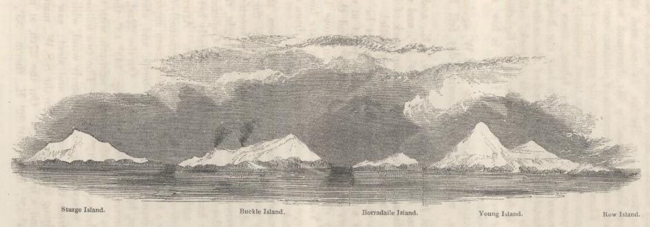
THE BALLENY ISLANDS.
Discovered 9th February, 1839. West Bluff of Centre Island in lat. 66° 44′ S., long. 163° 11′ E. Land bearing from West to East by South.
VOL. IX. 2 N
[page 524]
Blank page
[page] 525
water 34°. An amplitude at sunset, with the ship's head N.W., gave the variation 14° 54′ W.: thus, in the difference of 11 degrees of longitude, or a distance of about 250 miles in this parallel, the variation had changed 32° 45′, or nearly 3 points.
"March 1st.—With a steady breeze from the S.E. continued standing to the westward—passed several icebergs, and numerous flocks of penguins, petrels, and mutton-birds.
"March 2nd, A.M.—Squally from the S.E., with snow and sleet. At 8 cleared off a little. At noon, lat. obs. 64° 58′, long. 121° 8′, therm. 35°. P.M., Strong winds, and showers of snow and sleet; saw a great many birds. At 8, the water becoming smooth all at once, shortened sail, and hove-to. Saw land to the southward, the vessel surrounded by drift ice. At midnight strong breezes with snow.
"March 3rd, A.M.—Found the ice closing and becoming more compact; stood through the drift ice to the southward. At 8h. found ourselves surrounded by icebergs of immense size; to the S.W. the ice was quite fast, with every appearance of land at the back of it, but, the weather coming on thick, were obliged to steer to the northward along the edge of the pack. At noon, lat. by obs. 65° 10′, long. 117° 4′. P.M., Fresh breezes from the S.S.E. and clear; numerous icebergs in sight.
"March 4th.—Moderate and cloudy weather. At 5h. hauled to the westward; several icebergs in sight, and a great many birds and whales. At noon wind increasing, with a heavy sea from the N.W.; lat. obs. 63° 56′, long. by chron. at 4 P.M. 115° 30′. At sunset found the variations by ampl., with the ship's head N.E., to be 44° 11′ W. At 9h., being surrounded by icebergs with thick weather and heavy snow-squalls, hove the ship to for the night."
The two following days continued standing to the N.W., with variable winds. At sunrise on the morning of the 6th, in lat. 62° 40′, long. 164°, the variation by amplitude, with the ship's head to the N.N.W., was found to be 42° 21′ W. During the next four days, stormy weather with snow and sleet from the N.E.; stood to the N.W. whenever the numerous icebergs would allow the vessels to run. At midnight on the 10th, in lat. 61° 20′, the Aurora Australis shone with great splendour. The following day was very fine, with the wind from the N.N.E.: innumerable icebergs in sight. In the afternoon, in lat. 61° 27′, long. 105° 30′, the variation by azimuth was found to be 34° 30′ W.
During the next few days the vessels slowly made their way to the W.N.W., constantly surrounded by icebergs; saw whales, penguins, several sea-birds, and one albatross, the first seen since leaving Campbell Island; this occurred in lat. 61° 30′. May this be the southern limit of the range of this bird, probably the wandering albatross, which was seen by Mr. F. D. Bennett as far N. as lat. 38° S. off the coast of Brazil?*
March 13th.—Light variable winds from the eastward; surrounded by icebergs: in lat. 61°, long. 103° 40′, passed within a
* Journal, vol. viii., p. 211.—ED.
2 N 2
[page] 526
¼ of a mile of an iceberg about 300 feet high, with a block of rock attached to it, as represented in the following woodcut from a drawing made on the spot by Mr. John M'Nab, 2nd mate of the schooner.
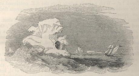
He describes the rock as a block of about 12 feet in height, and about one-third up the berg: it is unnecessary here to make any observation upon this very remarkable fact, as Mr. Charles Darwin has appended a note to these extracts, pointing out the value of such an evidence of the transporting power of ice:* we will, therefore, only add that this iceberg was distant 1400 miles from the nearest certainly-known land, namely, Enderby's Land, which bore W.S.W. of it. But it is highly probable, from the compact nature of the ice, &c., that land extends between the parallels of 66° and 68° S., in which case the iceberg would not be distant above 300 miles from this supposed land. The appearance of land seen by Captain Balleny on the 3rd of March, as above-mentioned, bore from the iceberg E.S.E., distant 450 miles.
On the following day the two vessels crossed the track of our great circumnavigator Cook in 1773, and, continuing to the north-westward, they on the 18th, in lat. 58°, long. 95° 15′, crossed the route of Bellingshausen in 1820. On the 21st, in lat. 55°, the autumnal equinox of these latitudes was rendered brilliant by a magnificent display of the Aurora Australis—numerous icebergs in sight, with penguins and various sea-birds. They now crossed Biscoe's track in April, 1831, being the third of the parallel routes, all running to the E.N.E., which occur here within about 5° of latitude; and on the following day encountered a strong gale of wind from the W., with a heavy sea running. In the afternoon of the 24th the gale had much increased; at midnight the cutter Sabrina burnt a blue light, distant 1 mile to the S.S.E.: this was answered immediately with another by the schooner, but the sea was running so high that she could not close the cutter.
* See Mr. Murchison's Silurian System, p. 541, who notices the great range of icebergs as seen by Captain Vernon Harcourt, R.N., in lat. 50° S. Also Mr. Bennett's Voyage in the Geographical Journal, vol. vii. p. 212.
[page] 527
March 25th..—Strong gales and squally weather—the vessel labouring and pitching violently. At daylight, says Captain Balleny's journal, "No signs of the poor cutter being in sight—I trust she may be safe." At 9h. a heavy sea broke on board the schooner, staving both boats, and sweeping everything from the decks, and laying the vessel on her beam-ends: for ten minutes she appeared to be settling in the water, but she gradually righted, and on sounding the well did not appear to be making much water. At noon, blowing a heavy gale from the W., with dark cloudy weather. Lat. by account 52° 15′, long. 94° 15′ E.
On the following day the gale moderated, and the schooner was enabled to stand to the northward, with the wind from the N.W. In lat. 49° they passed a quantity of sea-weed, and were surrounded by numerous penguins, divers, and other sea-birds. On the 1st April the Eliza Scott crossed the parallel of 45°, standing towards the Mozambique channel; and on the 17th September again reached the port of London, just in time to supply another Antarctic expedition, on the eve of its departure from England, with the information they had been enabled to obtain of a newly-discovered group of islands in the South-Frozen Ocean.
On looking at the excellent south circumpolar chart, just published at the Hydrographic Office, it will be seen that this voyage exactly fills up the gap of about 80 degrees of longitude within the parallel of 60°, which, on a former occasion, we pointed out as hitherto not sailed over by any navigator.* About 5 degrees of this navigation was within the polar circle. It were needless to recapitulate here the several voyages which, combined, have effected the circumnavigation of the globe within the parallel of 60°, as a glance at the above-mentioned chart, showing even the track of this voyage, will illustrate it far better than any description; and to that, then, we may refer all those who take an interest in the subject.
It would be impossible to close the simple but apparently faithful narrative of this voyage without adverting to the progress made in discovery in the Southern Seas through the spirited exertions of Mr. Charles Enderby, and other British merchants, so honourable to the commercial enterprise of our country. Graham Land, Enderby Land, Kemp Land, and now the Balleny Isles, are all discoveries made by the ships belonging to this disinterested and praiseworthy owner. The results of this voyage must tend to keep alive the supposition of the existence of either a great southern land or a vast mass of islands, whose northern
* Letter to the President of the R. G. S. on Antarctic Discovery, 1836, p. 12.
[page] 528
limits would seem to range between the 67th and 69th parallels, a part of which we trust, ere long, to see laid down in our charts, and not improbably rendered subservient to the interests of science, if not to the prosperity of our fisheries. Still less can we refrain from adverting to the expedition of the Erebus and Terror, commanded by Captain James Ross, which has recently left our shores, liberally fitted out by her majesty's government in the most complete manner, for scientific purposes, of any ships that ever sailed from Europe; and it is gratifying to know that the voyage of the Eliza Scott cannot but prove useful towards the success of the greater expedition, inasmuch as the Balleny Isles are situated exactly on the eastern verge of the circle traced by Captain James Ross on his chart, as the limit within which he hoped to find the southern magnetic pole; and thus their discovery will almost insure him a spot for planting his instruments at one of the places most desirable for making observations on magnetic dip, variation, and intensity.
And, although this latter expedition is mainly fitted out with the object of deciding the great problem of terrestrial magnetism in the southern hemisphere, and that its attention will be chiefly directed to this branch of physical geography, we cannot but hope that it may also do much in the cause of Antarctic discovery, and conclude with the earnest wish that the well-known zeal and ability of the gallant commander may be crowned with success, and that he may safely return to his country and his friends to receive the well-merited reward of his toils, in the applause and esteem of all civilized nations.