[front cover]
ACTA
VULCANOLOGICA
20 · 1-2 · 2008 / 21 · 1-2 · 2009
A VOLUME DEDICATED TO
PROFESSOR FABRIZIO INNOCENTI
Pietro Armienti, Massimo D'Orazio and Sergio Rocchi Editors
OFFPRINT

FABRIZIO SERRA EDITORE
PISA · ROMA
[page break]
EDITORS
PIETRO ARMIENTI, MASSIMO D'ORAZIO, SERGIO ROCCHI,
Dipartimento di Scienze della Terra, Università di Pisa, Via Santa Maria 53, I 56126 Pisa (Italy)
EDITORIAL BOARD
PATRICK ALLARD (Gif/Yvette, France) · ANTONELLA BUCCIANTI (Florence, Italy)
FABRIZIO CUCCOLI (Florence, Italy) · GIUSEPPE DE NATALE (Naples, Italy)
SAM J. FREETH (Swansea, UK) · JOSÉ LUIS MACÍAS (Mexico City, Mexico)
CLIVE OPPENHEIMER (Cambridge, UK) · MICHAEL R. RAMPINO (New York, USA)
MAURIZIO RIPEPE (Florence, Italy) · HAZEL RYMER (Milton Keynes, UK)
HIROSHI SHINOHARA (Tsukuba, Japan) · KEVIN M. SCOTT (Vancouver, USA)
YURI TARAN (Mexico City, Mexico) · DARIO TEDESCO (Caserta, Italy)
JEAN-PAUL TOUTAIN (Toulouse, France)
Manuscripts may be submitted to one of the Editors.
PUBLISHING HOUSE INFORMATION
«Acta Vulcanologica» is published six-monthly (June and December)
by Fabrizio Serra editore®, Pisa · Roma.
Subscriptions should be sent to Fabrizio Serra editore®, Casella postale no. 1, Succ. no. 8, I 56123 Pisa (Italy),
tel. +39 050 542332, fax +39 050 574888
fse@libraweb.net, www.libraweb.net
Pisa Office: Via Santa Bibbiana 28, I 56127 Pisa (Italy)
Rome Office: Carlo Emanuele I 48, I 00185 Rome (Italy)
I prezzi ufficiali di abbonamento cartaceo e/o Online sono consultabili
presso il sito Internet della casa editrice www.libraweb.net.
Print and/or Online official subscription rates are available
at Publisher's web-site www.libraweb.net.
Payments can be made on our postal current account no. 17154550
or by credit card (American Express, Visa, Mastercard, Eurocard)
Direttore responsabile: Alberto Pizzigati
Autorizzazione del Tribunale di Pisa n. 14 del 24 maggio 1991
«Acta Vulcanologica» is a Peer-Reviewed Journal
[page] 223
Special Issue
CHARLES DARWIN GEOLOGIST
AT SANTIAGO (CAPE VERDE ISLANDS):
A FIELD REAPPRAISAL
GIORGIO PASQUARÈ*,1 · GUIDO CHIESURA2 · TEODORO ALDO BATTAGLIA2
ILARIA GUARALDI VINASSA DE REGNY3 · FEDERICO PEZZOTTA3
1. Università degli Studi, Milano, Italy
2. Soil S.r.l., Milano, Italy
3. Museo Civico di Storia Naturale, Milano, Italy
ABSTRACT
Darwin's visit to the island of Santiago of Cape Verde as first stop of his journey around the world had a fundamental role for the maturation of his interest for Geology, a science that he considered to be his main research subject in the naturalistic field. In the 180 years that separate us from this event, no geologist has ever followed Darwin's footsteps to reconstruct the objectives, the methods and the results of his research on the island. Quotations found on biographical or historical texts are the only traces left of it, while in geological literature Darwin's contribution to Santiago's geology is almost completely absent. Also as a consequence of that, even in more recent works, same faults appear about the geomorphology and stratigraphy of the southern part of the island. The objective of this work is therefore to fill these gaps by means of a field revision of Darwin's geological observations, their interpretation and completion, taking into consideration the knowledge, the methodology and the opportunities offered by his time.
KEYWORDS: Darwin, «Beagle», Mantle Plume, Elevation Craters, Basaltic Lava Flows
1. INTRODUCTION
The present work is dedicated to the memory of Fabrizio Innocenti, who masterfully conciliated the objectivity of scientific observation and his profoundly religious soul.
The article presents the reconstruction and revision of the geological observations made by Charles Darwin at Santiago of Cape Verde on the first leg of circumnavigation of the globe he completed under the title of «Naturalist», on board the bark «Beagle» of the British Navy. The first true geological experience of Charles Darwin has a significance that transcends the specific episode. On his own admission, the three weeks passed on the arid ground of the Island of Santiago made of Darwin a geologist and of that geologist an author of scientific theories and geological texts. Our exercise thus had the specific idea of visiting areas and their geological structures (FIG. 1) that would see the young Darwin engaged in explaining the outcomes which the science of that day allowed him, along with the perplexities and limitations thereby entailed, to read his campaign notes taking into account the level of knowledge and the conditioning of the epoch.
With this work it is our intention to offer a geologists' tribute, perhaps modest but impassioned, to the first reflections of that genius who became a geologist right from the start of his scientific activities and remained as such ever after. A tribute due also because in the almost one hundred and eighty years dividing us from that occasion, only Pearson and Nicholas (2007) have revisited in person Darwin's work on Santiago of Cape Verde. Their work consisted moreover in an eminently historic investigation, in which the authors deal only with those aspects of Darwin's research useful to maintain that at Santiago he may have been far from abandoning catastrophism in favour of gradualism and that his Lyellian 'conversion' might have been very gradual during the further course of his voyage and certainly not effected while he was staying at Cape Verde.
2. HISTORICAL OUTLINE
Charles Darwin's encounter with geology came about at the end of a troubled academic passage. After a brief period of medical studies at Edinburgh he switched to Christ's College, Cambridge, for a course of theology. Here he enjoyed natural history studies but not the geology after attending to a few lectures by the neptunist R. Jameson while in Edinburgh. At Cambridge his botany professor John Henslow led the young student through a stimulating and beneficial course, later becoming his friend, mentor and scientific sponsor. Henslow opportunely persuades him to add geology to his program and encourages him to follow Adam Sedgwick, illustrious Cambridge professor of that science, on a field study course in Wales in summer 1831. In the meantime Darwin, greatly inspired by his reading of Alexander von Humboldt's Personal Narrative, confides in Henslow his dream of visiting the Canary Is-
* Corresponding Author: G. Pasquarè: giopa20@gmail.com
[page] 224
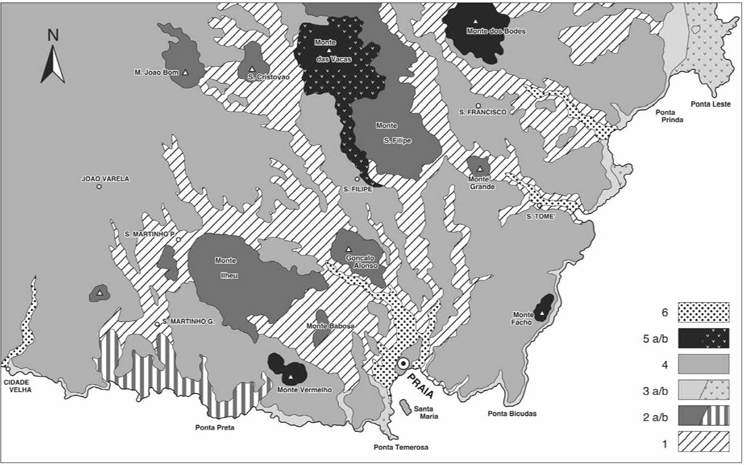
FIG. 1. Geological sketch-map of the studied area: 1. Old submarine basement; 2. Monte San Filipe Fm.: a-subarerial lava flows, b-littoral autoclastic lavas; 3. Ponta Temerosa Fm.: a-subaerial lava flows, b-littoral autoclastic lavas; 4. Pico de Antonia basalts; 5. Basaltic scoria cones: a-tephra, b-lava flows; 6. alluvial and estuarine deposits.
[page] 225
lands together with him and other students. A series of refusals on behalf of other possible participants and fortunate coincidences leading to an offer of departure for the Canary Islands, arrives to none other than Charles Darwin, unmarried and 'raring-to-go' naturalist. The itinerary of the ship, the Beagle commanded by Robert FitzRoy plans to dock first on the Island of Tenerife in Canary Islands. Overcoming paternal resistance, the young man embarks and two months later the longed for destination draws into sight, announced by the unmistakable profile of the summit of Teide Volcano rising above the clouds. Unfortunately however, disembarkation at Tenerife is refused by the port authorities due to news of a cholera outbreak in England in the meantime, and the mirage draws away from the poop of the «Beagle» as she alters course for the Island of Santiago in the archipelago of Cape Verde.
The field of action that is offered to the curiosity and enthusiasm of the young naturalist is not a botanical garden, a greenhouse of tropical plants, but a barren volcanic island that immediately challenges Darwin's scarce preparation in geological science. It is to be his baptism in geology, and already after the first day his immersion in complex stratigraphic, morphologic and volcanologic problems will be as good as total, so much so, that in the comments in his Notebooks, Nora Barlow writes «A brief line, "Wild cats, Kingfisher", is the only zoological note in the Cape de Verde; his mind was absorbed in the geological puzzle». In the continuation of his voyage Darwin is to collect an enormous documentation in all fields of natural science, with a net preponderance of geological observations with respect to the zoological and botanical ones, considering that 1383 pages of geological notes remained to posterity against 368 pages of botanical and zoological notes.
Darwin's geological activity continues, with alternate phases of decreasing commitment, until around 1850. He becomes a member of the Geological Society of London in 1836, was proposed for the job of secretary to President Murchison in March 1837, which he turned down alleging an inadequate knowledge of British geology. Subsequently he acted as second secretary from February 1838 until February 1841.
In 1845 the definitive edition of the «Journal of Researches» into the natural history and geology of the countries visited during the voyage of H.M.S. «Beagle» round the world, under the Command of Captain FitzRoy, have been published. The geological observations that constitute the corpus of the Geology of the «Beagle» were separately published in three volumes: «Structure and Distribution of Coral Reefs» (1842); «Geological Observations on Volcanic Islands» (1844); «Geological Observations on South America» (1846).
Contemporary geologists can still read these three works both with benefit and surprise. In the first volume Darwin formulates a theory on the formation of coralline structures in the Pacific, based on the assumption of gradual subsidence of the support of the base of the coralline structures, that is, of the oceanic volcanic islands, that unify the three fundamental structures of those constructions: the breakwater reefs, the barriers and the atolls. This work is still now considered valid and has been confirmed by numerous oceanographic explorations. In the second of the cited texts, Darwin articulates a theory on magmatic gravitative differentiation, while in the third he tackles three fundamental subjects: tectonic phenomena, that is, the upward raising of vast continental areas; metamorphism: the cleavage of rocks as distinct from their stratification; and last of all palaeontology: the excavation of bones of extinct mammals in the Pampas and their connections with living species. Of considerable importance also is his essay presented in 1838 to the Geological Society entitled «On the connection that exists between certain volcanic phenomena in South America and on the formation of mountain chains and of volcanoes as an effect of the same forces that raise the continents». H. T. Rhodes Frank (1991) analysed this essay and in the conclusive paragraph judges the theoretical scheme of the global tectonics traced by Darwin as «an almost prophetic statement of the mechanism that was to be discovered well over a century later», with clear allusion to the theory of plate tectonics.
3. THE DARWIN'S GEOLOGICAL INVESTIGATIONS AT SANTIAGO
During his stay at Santiago Darwin produced several geological and naturalistic notes as well as his personal impressions. In order of compilation they are as follows:
- The two 'manuscripts' referable to Santiago and to Quail Island presumably compiled by pen with pencilled additions, 'on location' between 16 January and 8 February 1832: fragmentary notes, frequently in the form of informal written messages almost exclusively of geological content, with numbered samples of the rocks collected. The prose is discontinuous and often unpunctuated. The first manuscript is conserved in the Cambridge University Library, the second, which contains two sections from Quail Island, is at Downe House. It appears that they were reworked by Darwin himself during the voyage and on his second passage in 1836.
- «The On-Board Diary», with notes almost daily on his day's activities, the itineraries and his excursion companions, descriptions of the scenery, personal emotions. These notes were presumably compiled on board the «Beagle» at each day's end.
- Letters written to his father, sisters and to his friend professor Henslow, on different dates subsequent to his stay at Santiago, presumably just before the arrival of an opportunity to send post to England.
- «The Journal of Researches», combined in what is known as «Voyage of a naturalist around the world», initially compiled and published as the third volume (the first two are Captain FitzRoy's) of the account of the expedition of the «Beagle», then reprinted as a separate volume.
- «Volcanic Islands» compiled during 1843 and published in spring 1844.
[page] 226
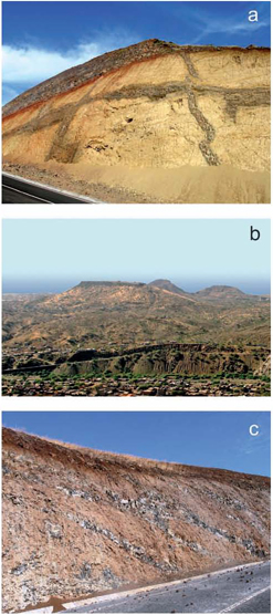
FIG. 2. a) Massive hyaloclastites and mafic dykes of the old submarine basement, unconformably covered by Pico de Antonia basalts; b) one of the Darwin's truncated conical hills: the Monte Babosa. In the background the two scoria cones of Monte Vermelho; c) topsets and foresets in a nephelinite lava delta of Monte San Filipe Fm.
- The texts taken into consideration for the preparation of the expedition and also for the re-examination of the Darwinian geological itineraries on Santiago are the Santiago and Quail Island manuscripts, «The On-Board Diary», as well as chapter 1 of the text of «Volcanic Islands», comprise the definite selection of the geological notes on the subject.
From an examination of the above texts it emerges that the itineraries Darwin followed on the island, departing from the town of Praia, grew to an average projection of about 15 km towards the hinterland. The reconstruction of the geological set up in this sector of the island started with the identification of an old submarine basement which he named the «Lowest Series», in which he recognised autoclastic, intensely altered submarine basaltic lavas, intersected by dense systems of igneous mafic dykes characterized by a great aboundance of augite (FIG. 2a) Along the coastal headland Darwin observes that these ancient rocks are unconformably covered by a sub-horizontal sedimentary layer of six meters average thickness composed prevalently of calcarenites rich in oyster shell, pecten, turritella, patella, corals, and echinoderms (FIG. 3a). In acknowledging the prevalence of living species up to present day in the marine coastline, he attributes the age of this marker-bed to the Upper Tertiary. Since he recognizes the indicative importance of a generalised upward movement of Santiago, for this layer he supplies data regarding the lithology, stratigraphy and palaeontology, quite detailed above all in the small island of Quail, today called Santa Maria, where he had established his operating base. The sedimentary marker is situated a few meters a.s.l. but in some cases it sinks below the sea, according to an interpretation proposed by Darwin that will be referred later.
Corresponding to the long and articulated coastline, Darwin observes that the calcarenitic marker level is conformably covered by an autoclastic lava emplaced in a littoral environment and in its turn covered by a thick pile of columnar jointed basaltic lava flows (FIG. 3b). His attention is particularly directed to the nature of the contact between the submarine basaltic flow-breccia and the sedimentary layer, with an accurate description of their complex interplay and the development of the thermo-metamorphic effects. The correlation between the coastal stratigraphy and the geology of the inner part of the island poses problems for Darwin, not least for the difficulty of negotiating such a vast and uneven area in the limited time dictated by Captain FitzRoy's schedule.
Darwin recognizes first of all the presence of rocks of his «Lowest Series» both along the numerous deep valleys intersecting extensive lava platforms and in different hills emerging from the platforms. Among these hills he distinguishes six prominent truncated conical hills composed by the old submarine volcanic rocks covered by thick basaltic plates (2b). The original extent of the tabular basalt flows would have been much larger and would have constituted a basaltic tableland slightly inclined toward the sea and resting upon the peneplaned surface of its «Lowest Series», on whose origin Darwin doesn't dwell. He appears to be in doubt in deciding whether the flows of the basaltic tableland had taken place in undersea or open air conditions. He also observes that the six truncated conical hills form a semicircular arc with the concave shape facing toward the interior of the island.
[page] 227

FIG. 3. a) Biocalcarenite from the Darwin's «uplifted beach»; b) Pillow-breccias and pillow-lavas of the upper Ponta Temerosa Fm. flowing on the Darwin's «uplifted beach» and covered by Pico de Antonia basaltic flows; c) Detail of the contact between the Darwin's calcarenite horizon and a basaltic lava flow of the lower Ponta Temerosa Fm.; d) One of the flat-floored, steep-flanked valleys that drew Darwin's attention.
In a paragraph of his work published in 1844 and dealing with his geological observations on volcanic islands, he takes up the morphology and structure of the great basaltic platforms of Santiago associating them with similar occurrences later observed on Saint Helens and Mauritius Islands. In all three cases he maintains that the basaltic tablelands constitute the margins of great depressions allied to the typology of elevation craters according to the theories of Leopold Von Buch and Jean-Baptiste Elie de Beaumont (according to these theories, the elevation craters developed from inflation of the ground because of the high-pressure vapour rising from subsurface magmatic bodies; after the vapours have escaped, the uplifted mass falls down forming huge craters, later called calderas; subsequently, if a canal between the crater and the earth's interior remains open, lavas and tephra can rise from it forming an eruption cone with its eruption crater inside the elevation crater). Here Darwin distances himself from the models proposed by the above Authors, proposing that the upward movement might never have formed a large dome-like hill, since the endogenous energy responsible for the structure would have been dissipated in the central part of the structure itself as a consequence of the eruptive liberation of the magma and the volcanic gases. The residual endogenous energy would have raised the marginal annular portion of the structure releasing it from the central depression through curved fault planes which today should be considered as listric faults.
Darwin then describes a very extended covering of subaerial basaltic lava flowing down from the high internal slopes of the island and reaching the costal cliffs. These basaltic flows run along the deeply eroded surface of the previous basaltic tableland and they are cut by the present sea cliffs in form of an extended plateau. The foregoing is at the origin of that terraced or stepped morphology of Santiago which Darwin described at the moment he observed the overall aspect of the island from the deck of the Beagle.
Darwin later turns his attention to other pap-form or conical hills rising around Praia, interpreting them as isolated volcanic centres emplaced over the subaerial basaltic lava fields. One of them, given by him as Signal PostHill and known today as Monte Facho, rises near the border of the basaltic plateau to the north-east of Praia as a group of three cones of coalescent basaltic scoria, the largest of which displays a crater-like structure surrounded by a ring dyke. Darwin maintains that it is related to a submarine centre of volcanic activity, in whose
[page] 228
rather disturbed morphology he envisages the demolishing action of wave movement. A lava flow coming from Monte Facho would have descended southwards along a channel carved in the basaltic plateau.
Examining the costal cliffs over which Monte Facho looms, he observed that the calcarenitic marker-bed running horizontally at a height of six meters above sea level, falls below sea level under the volcano, reappearing subsequently to occupy its common altitude a.s.l. The interpretation of this structure is also taken up again by Darwin in his «Geological Observations on Volcanic Islands», dealing with elevation craters. In this case the rather reduced dimensions of the phenomenon induce him to maintain that in this case the endogenous pressures were relatively weak and therefore the connection between the moderately raised annular portion and the central depression consisted of a flexural deformation rather than a listric-type faulting.
Darwin subsequently pays a lot of attention to the study of an eruptive center made up by two scoria cones, north-west of Praia, which he called Red Hill, today Monte Vermelho (FIG. 2b), to the largest of which he attributes emission of a sizeable basaltic flow that would have reached the coast. Near the summit of the volcano he also observes the presence of traces of floury calcareous clasts ripped by the magma from the sedimentary marker-bed before the eruption, intimately mixed with scoria fragments.
A further research subject Darwin tackles concerns the origin of the valleys which deeply scar the whole island following different orientations. He particularly concentrates on the stretches of the rivers cutting into the lava platforms near the coast, observing their large and flat valley floors bordered by steep flanks carved into the hard rock (FIG. 3d). In contrast to these wide valleys orientated in N-S and NE-SW direction there are narrower valley floors with a NW-SE orientation to which he assigns a younger age.
In the original 1832 manuscript Darwin expresses the opinion that these valley systems and the related morphology could be ascribed to unforeseen, catastrophic, meteoric events, whose effects he observed in the valley of Sao Domingos, impressed by its articulated somewhat steeple and tower-like rocky crests. The reference to the biblical flood appears here fairly explicit. In the text written twelve years later, Darwin changes this interpretation, proposing for the same valleys an origin by marine erosion contemporarily with a vigorous upward movement of the island. Whilst admitting the difficulty of explaining the total absence of sediments and marine fossils along these valley floors he anyway maintains his support for this latter hypothesis.
4. DARWIN'S GEOLOGICAL INVESTIGATIONS AT SANTIAGO COMMENTED AND REVIEWED
The Islands of Cape Verde are situated in the Atlantic Ocean, about 2,000 km east of the Mid-Atlantic Ridge, in correspondence with a large intraplate swell formed above a deep mantle plume (Pim et alii 2008). The historic character of our work however allows us to leave aside these aspects in order to connect directly to that pioneering phase of geology that moreover by this time had acquired full right to be numbered among the modern sciences. Therefore the work of revisiting the geological investigations conducted by Darwin at Santiago of Cape Verde covers the examination of the geological literature published after the voyage of the «Beagle» only for the aspects that are useful for direct or indirect connection to the work carried out there by Darwin himself.
Works of a certain prominence bearing on the regional geological framework and the geological evolution of the island were done by Serralheiro (1976) and Alves et alii (1979). The first consists of a voluminous regional geological monography, while the second, in which the same Serralheiro contributed the drafting, provides a geological map of the island to a scale of 1:100,000 with related explanatory notes. Both of these reports acknowledge in the area surrounding the town of Praia an old submarine eruptive complex of pre-Middle Miocene age, unconformably covered by submarine autoclastic lavas of Middle Miocene age. On both of them there are extended basaltic lava fields coming from the inside the island, with their equivalent littoral marine facies in proximity and along the present day coastal cliffs.
In spite of Darwin's work on Praia having been completed more than a century previously, his name does not appear in the bibliographical list of either of the above publications. These evidently determined future citing omissions of the geological work he contributed at Santiago, including the ones more recently performed regarding petrological, geochemical and paleomagnetic data on Santiago Island (Abranches et alii 1990; Martins et alii 2003, 2008; Holm et alii 2008; Barker et alii 2009; Knudsen et alii 2009).
Our field observations were carried out reconstructing and retracing all the itineraries followed by Darwin, also adding supplementary tracts studied for a better comprehension of the data and the observations contained in the Darwinian comments to the same itineraries. In Figure 1 a sketch is given taken from a geological map of the same area surveyed at a scale of 1:25,000 by G. Pasquarè during the present project. In the following lines, in the light of our observations we comment on the data and interpretations supplied by Darwin, according to the presentation of the subject matter contained in the preceding chapter.
In Darwin's «Lowest Series» one recognizes the predominance of mostly massive and sometimes bedded hyaloclastites and pillow breccias with hyaloclastic matrix, intersected by several systems of mafic dykes and sills (FIG. 2a). These submarine eruptive products probably moved as a fluid, dense and massive mass in the lower part and progressively vesicular in the upper bedded portion. The bedded hyaloclastites were probably turbulent low-concentration suspensions representing the distal parts of the hyaloclastic mass flows. The volcaniclastic rocks are crossed by multiple systems of
[page] 229
dykes formed during repeated, voluminous submarine lava extrusions. In the area north of Praia, profoundly altered masses of Fe-gabbros are observed and represent deeper portions of upraised oceanic crust.
The paleosurface of this Santiago's basal complex appears rather flat and generally devoid of intermediate deposits with the exception of a few alluvial deposits, already observed by Darwin who judged them to be formed on a plain next to the coast, whereas today they lie at an altitude of about 100 meters. Toward the interior of the island, outside the area studied, the surface of this paleorelief reaches 700 m. a.s.l. showing how the upward movement of the old oceanic basement of Santiago might have been conspicuous before the construction of the subaerial volcanic centers had caused the island to reach heights of near 2,000 m.
The oldest subaerial volcanic cover of this paleorelief rising up from the ocean and represented by flows forming the six truncated conical hills of Darwin's (FIG. 2b), are made up of melanephelinites and extend more extensive than he hypothesized inside the area he studied but also in the adjacent area toward north-east. The overall form of these lava flows suggests that they represent a large lava shield that extends until the valley of Sao Domingos where it is surmounted by the more evolved products of a large composite volcano strongly dissected by slope failures and by deep fluvial incisions. In the geological sketch of Figure 1 the lava flows of the shield are designated as the Monte San Filipe Formation, which represents the largest of the six truncated conical hills described by Darwin.
Approaching the coast around Ponta Preta, the lava flows of the shield, beginning from a height of about 60 m above sea level and until their immersion in the sea are transformed into spectacular lava deltas. These are made of alternate pillow breccias and thin and dismembered lava beds, forming thick foreset systems with average inclinations of about 30 degrees, covered as topsets by horizontal subaerial lava beds emitted during the same eruptive cycle. The overall structure of these lava deltas are quite similar to the ones designated as 'Gilbert-type deltas' in the fluvial geomorphology (FIG. 2c). These coastal lavas correspond partly to the Flamengos Formation of Serralheiro (1976) and Alves et alii (1979). These authors did not distinguish the nephelinitic lava beds on the summit of Darwin's truncated conical hills, from the successive basaltic lava fields coming from the Pico de Antonia volcano located North of the area considered here. They were consequently unable to identify the source of the submarine eruptive products belonging to the Flamengos Formation in this sector of Santiago.
A large erosive phase had newly modelled the island after the construction of the subaerial shield represented by the Monte San Filipe Formation, isolating the six truncated conical hills identified by Darwin according to a relatively planar surface having an average height of about 100 m less than the previous erosional surface. On this newer surface, no structure or deposit suitable for understanding its origin is recognizable. The surface itself is completely covered by new basaltic lava fields of basanitic composition forming a sub-horizontal tableland near to the coast while it progressively and gently tilts to join the Pico de Antonia volcanic complex. The latter is composed of a basal large shield on which a younger stratocone was built. This younger shield emitted the above-mentioned, basanitic large lava fields that reached as far as the study area, called Pico de Antonia basalts in the geological map of Figure 1.
Along the coast, in the neighbourhood of Praia and north-east of it, volcaniclastites and dykes of the old submarine complex are unconformably covered by a thin horizontal sheet of subaerial basaltic lavas. These latter are conformably covered by the the fossiliferous calcarenitic unit described by Darwin, which penetrates into the hollows of its scoriaceous crust indicating the lack of a consistent temporal hiatus between the two units (FIG. 3c). The calcarenitic unit is in turn capped by pillow lavas and volcaniclastic rocks rich in pillow fragments according to a marked disconformity between the Darwinian beach foreshore sediments and basaltic lavas emplaced in a definitely deeper marine environment (FIG. 3b). This situation can be easily observed near Praia, at Ponta Temerosa as well as in the northeastern portion of the area studied, around the promontory of Ponta Leste from where it continues northwards for a distance of at least 10 km. Along the terminal part of the valley of Sao Domingos, its flat and wide valley floor is represented by the horizontal surface of the subaerial lava flow above described. The flow is carved by a sequence of meanders encased in the hard basalt, bounded by vertical walls of 10 m height.
In the geological sketch-map (FIG. 1) all of the above described successions have been grouped into the Ponta Temerosa Formation, subdivided into a lower subaerial volcanic member and an upper submarine volcanic member. The sedimentary calcarenitic level placed between the two is not graphically representable. The Ponta Temerosa Formation, together with the intermediate sedimentary level, must be attributed to a marked environmental variability in a relatively short time interval which requires the presence of eustatic sea-level change mechanisms in the geological evolution of Santiago, a mechanism unknown at Darwin's times.
Scoria cones resting on the basaltic lava fields erupted from Pico de Antonia shield have no genetic relationship and are separated by temporal hiatuses. Scoria cones directly related with the grow of the shield are instead recognizable around the village of Rui Vaz, north of the area here studied. The cones of Monte Vermelho and Monte Facho did not produce lava effusions, contrarily to the affirmation of Darwin, while the large spatter cone of Monte das Vacas has emitted numerous basanitic lava flows, one of which descended for 2 km along a valley excavated in the Pico de Antonia basalts. Darwin had certainly seen this volcano during his itinerary towards Sao Domingos, but left no annotation about it. Another big scoria cone, Monte dos Bodes, was neither described nor seen by Darwin, probably being on the margins of its itineraries.
[page] 230
Regarding the aspects that induced Darwin to acknowledge the presence of elevation craters in the studied area we especially note that the biggest of them is represented by an ample collapse involving the north flank of Pico de Antonia. It was probably a polyphasic sector collapse affecting also the portion of the large composite volcano stratigraphically situated between the Pico de Antonia and the basaltic shield of Monte San Filipe. The products of this important event are represented by mud flows, debris flows and lahars recognised by Serralheiro (1976) and represented in the geological map of Alves et alii (1979) as Orgaos Formation, overlying the old submarine complex as well as the Flamengos Formation. The lack of pyroclastic deposits indicative of explosive paroxysms lead to the exclusion of a summit caldera collapse. By the way we recall how recent geophysical and batimetric investigations (Le Bas et alii 2007) recognised evidences of extended collapse of some undersea flanks of Santiago, characterised by avalanche debris, turbidite pathways and debris flows.
In the case of Monte Facho the progressive immersion of the calcarenitic layer below sea level described by Darwin, in the costal profile nearby the eruptive centre, seems to be simply due to the effect of the very gentle tilt of the layer itself toward the sea, combined with the presence of a protuberance of the shore line in correspondence with the volcano.
For what concerns the problem raised by Darwin about the origin of the particular morphology of the valley floors (FIG. 3d), we have to affirm that their origin through fluvial erosion and alluvial transport is obviously beyond doubt but it is also clear that during a phase of high sea level, their terminal tracts were transformed into long and wide estuaries. This is especially evident in the valleys that converge towards the city of Praia where coalescence gave birth to a large estuary, today partially invaded by the sea in correspondence with the omologous bay. On this theme we should maintain that the basaltic plateau on which the historic center of the city rises, and the island of Santa Maria as well, were islands emerging from the previous estuary. On the Island of Santa Maria, as described in detail also by Darwin, the lowest portion of calcareous marker-bed is substituted by layers of fluviatile gravels and sands, witnessing alternation of marine sedimentation with alluvial floods.
5. CONCLUSIONS
Most of Darwin's geological conceptions were based on the idea of continuous and balanced interactions between the crust of the continents and the oceanic floors, following vertical vectors. In this picture, the close connection between seismic, volcanic and orogenic activities holds an important position. Moreover, on the basis of his geological experiences, especially those acquired in South America, Darwin conceived the idea of an Earth considerably older than estimated by his contemporaries. Darwin's Earth model was that of a 'temporal container', wide enough to include his evolutionist theory of the organisms.
His research methodology was mainly based on detailed field observations and collecting of data, which he then put in a complex and sometimes rather obscure informative system. In Santiago, Darwin overcame his young age and lack of geological experience through a resolute engagement in placing his observations in the frame of interpretative models. The uplifting of about 10 m a.s.l. of a biocalcarenitic horizon deposited along a former beach represents his first challenging discovery. Impressed by the evidence of the uprising of the island, Darwin sought further proof of that, also making some mistakes, such as the submarine emplacement of the massive columnar basalts of its tronco-conical hills. Darwin was a supporter of Von Buch's Elevation Craters theory, which he later refused, and this led him to recognize the large Pico de Antonia volcano sector collapse. His idea of a marine origin of the Santiago valleys is obviously incorrect, but it could be partially explained if we consider the formation of large estuarine basins during the longitudinal profile evolution of the valleys themselves.
All the above cited stratigraphical, paleontological, volcanological and geomorphological observations made by Darwin in Santiago were clearly addressed to the geological evolution of the island. During the survey of the geological map of the Praia area, presented in this paper, the stratigraphic units by him directly or indirectly recognized were used. Their validity and utility, as confirmed in a present-day geological survey, reveal the very promising qualities of the geologist Charles Darwin, as he will largely confirm during the prosecution of his great journey.
ACKNOWLEDGEMENTS
We are grateful to Pietro Armienti for his careful revision and Corrado Venturini for helpful comments. We thank the Municipality of Milan, Istituto Nazionale di Geofisica e Vulcanologia, Soil S.r.l. and Nestlè Italiana S.p.a. for financial support. We thank also Dr. Antonio Querido, University of Cape Verde, for his hospitality and interest in the present project. A grateful appreciation is also due to Selene Pasquarè for her revision of the English version. The project was promoted by Associazione Ardito Desio, Roma.
REFERENCES
Abranches M. C., Storetve dt K. M., Serralheiro A., Lovlie R. (1990). The palaeomagnetic record of the Santiago volcanics (Republic of Cape Verde): multiphase magnetization and age considerations. «Phys. Earth Planet. Int.», 64, 290-302.
Alves C. A. M., Macedo J. R., Celestino Silva L., Serralheiro A., Peixoto Faria A. F. (1979). Estudio geologico, petrologico e vulcanologico da ilha de Santiago (Cabo Verde). «Garcia de Orta. Serie de geologia», 3, 47-74.
Barker A. K., Holm P. M., Peate D. W., Baker J. A. (2009). Geochemical stratigraphy of Submarine Lavas (3-5 Ma) from the Flamengos Valley, Santiago, Southern Cape Verde Islands. «J. Petrol.», 50, 169-193.
Barlow N. (1945). Charles Darwin and the Voyage of the Beagle, London, Pilot Press.
Darwin C. (1845). In: R. FitzRoy (ed.), Journal and Remarks, 1832-1836. Narrative of the Surveying Voyages of His Majesty's Ships Adventure and Beagle between the years 1826 and 1836, London, John Murray.
[page] 231
Darwin C. (1842). The Structure and Distribution of Coral Reefs, London, Smith, Elder & Co., printed by Steward and Murray, Old Bailey.
Darwin C. (1844). Geological Observations on Volcanic Islands, London, Smith, Elder & Co.
Darwin C. (1846). Geological Observations on South America, 1st edn., London, Smith, Elder & Co.
Darwin C. (1958). Autobiograpy, ed. by Francis Darwin, New York, Dover Publications.
Holm P. M., Grandvuinet T., Friis J., Wilson J. R., Barker A. K., Plesner S. (2008). An Ar-Ar study of the Cape Verde hot spot: Temporal evolution in a semistationary plate environment. «J. Geophys. Res.», 113, B08201.
Keynes R. D. (ed.) (2001). Charles Darwin's Beagle Diary, Cambridge, Cambridge University Press.
Knudsen M. F., Holm P. M., Abrahamsen N. (2009). Paleomagnetic results from a reconnaissance study of Santiago (Cape Verde Islands): Identification of cryptochron C2r.2r-1, 2009. «Phys. Earth Planet. Int.», 173, 279-289.
Le Bas T. P., Masson D. G., Holtom R. T., Grevemeyer I. (2007). Slope failures of the flanks of the southern Cape Verde Islands, in V. Lykousis, D. Sakellariou and J. Locat (eds.), Submarine Mass Movements and their Consequences, 337-345, Dordrecht (Netherlands), Springer-Verlag.
Rhodes F. H. T. (1991). Darwin's search for a theory of the earth: symmetry, simplicity and speculation. «British J. Hist. Sci.», 24, 1991.
Martins S., Mata J., Munha J., Madeira J., Moreira M. (2008). Evidencias geologicas e geoquimicas para a existencia de duas unidades estratigraficas distintas na formacao do Pico de Antonia (Ilha de Santiago, Republica de Cabo Verde). «Memórias e Notícias», n.s., 3, 123-128.
Martins S., Mata J., Munha J. (2003). Chemical evidence for complex and variable mantle residual paragenesis in the Santiago Island (Cape Verde). «Memórias e Notícias», n.s., 2, 19-37.
Pearson P. N., Nicholas C. J. (2007). "Marks of extreme violence": Charles Darwin's geological observation at St Jago, Cape Verde Islands («Geol. Soc. London Spec. Publ.», 287), 239-253.
Pim J., Peirce C., Watts A. B., Grevemeyer I., Krabbenhoeft A. (2008). Crustal structure and origin of the Cape Verde Rise. «Earth Planet. Sci. Lett.», 272, 422-428.
Serralheiro A. (1976). A geologia da ilha de Santiago. «Bol. Mus. Lab. Min. Geol. Fac. Cienc. Lisboa», 218 pp.
Von Humboldt A. (1995). Personal Narrative of a Journey to the Equinoctial Regions of the New Continent, London, Penguin Classics, 310 pp.
[page break]
[page break]
Proprietà riservata · All rights reserved
© Copyright 2010 by
Fabrizio Serra editore®, Pisa · Roma
www.libraweb.net
Stampato in Italia · Printed in Italy
ISSN 1121-9114
ISSN ELETTRONICO 1724-0425
[page break]
A VOLUME DEDICATED TO
PROFESSOR FABRIZIO INNOCENTI
Pietro Armienti, Massimo D'Orazio and Sergio Rocchi Editors
CONTENTS
| Fabrizio Innocenti (1939-2009) | 9 |
| ANDREA DINI, SERGIO ROCCHI, DAVID S. WESTERMAN, FEDERICO FARINA, The late Miocene intrusive complex of Elba Island: two centuries of studies from Savi to Innocenti | 11 |
| SAMUELE AGOSTINI, CARLO DOGLIONI, PIERO MANETTI, SONIA TONARINI, The 40-year contribution of Fabrizio Innocenti to understanding the geodynamic evolution of the Eastern Mediterranean | 33 |
| GIAMPIERO POLI, GEORGIOS CHRISTOFIDES, ANTONIS KORONEOS, TRIANTAFYLLOS SOLDATOS, DIEGO PERUGINI, ANTONIO LANGONE, Early Triassic granitic magmatism – Arnea and Kerkini Granitic Complexes – in the Vertiskos Unit (Serbo-Macedoniam Massif, North-Eastern Greece) and its significance in the geodynamic evolution of the area | 47 |
| GEORGIOS E. VOUGIOUKALAKIS, MICHAIL FYTIKAS, NIKOS KOLIOS, LORELLA FRANCALANCI, Cenozoic volcanic activity in Greece | 71 |
| FABRIZIO INNOCENTI, PIERO MANETTI, ROBERTO MAZZUOLI, PIERO PERTUSATI, MICHAIL FYTIKAS, NIKOS KOLIOS, GEORGIOS E. VOUGIOUKALAKIS, NIKOS ANDROULAKAKIS, SALVATORE CRITELLI, LUCA CARACCIOLO, Geological map (scale 1:50,000) of Limnos Island (Greece): explanatory notes | 87 |
| YOTZO YANEV, ROSITSA IVANOVA, Paleogene ultrapotassic volcanic rocks of the Eastern Rhodopes (Southern Bulgaria): Petrology, mimeralogy and origin | 99 |
| PIETRO COMIN-CHIARAMONTI, ALDO CUNDARI, EXCELSO RUBERTI, ANGELO DE MIN, JOHN GITTINS, CELSO DE BARROS GOMES, LALCHAND GOVINDRAM GWALANI, Genesis of Analcime and Nepheline-Potassium Feldspar-Kalsilite Intergrowths: a review | 123 |
| GIACOMO CORTI, PIERO MANETTI, TSEGAYE ABEBE, MARCO BONINI, FRANCESCO MAZZARINI, The volcanotectonic activity of the Main Ethiopian Rift (East Africa): insights into the evolution of continental rifting | 133 |
| PIETRO ARMIENTI, DANIELA GASPERINI, CRISTINA PERINELLI, KEITH D. PUTIRKA, A new model for estimating deep-level magma ascent rates from thermobarometry: an example from Mt. Etna and implications for deep-seated magma dehydration | 145 |
| RICCARDO PETRINI, LUCA ZIBERNA, CALOGERO PINZINO, The distribution of paramagnetic centers in glass and lavas from eruptive activity at Mt. Etna: implications for magmatic processes during basaltic eruptions | 159 |
| ANGELO PECCERILLO, KEEGAN ALAGNA, CARMELITA DONATI, The Radicofani Volcano: a window on a complexly zoned upper mantle beneath Southern Tuscany (Central Italy) | 167 |
| SIMONE TOMMASINI, LORELLA FRANCALANCI, RICCARDO AVANZINELLI, CHIARA MARIA PETRONE, The Subduction Factory of the Aeolian Volcanic Arc | 177 |
| SERGIO ROCCHI, GIANFRANCO DI VINCENZO, CLAUDIO GHEZZO, LAURA BRACCIALI, MAURIZIO GEMELLI, The early Paleozoic antarctic Margin of Gondwana: a synthetic Model after twenty Years of Investigations | 193 |
| MASSIMO D'ORAZIO, The Cenozoic Basalts from Central-Southern Patagonia: a review | 209 |
| GIORGIO PASQUARÈ, GUIDO CHIESURA, TEODORO ALDO BATTAGLIA, ILARIA GUARALDI VINASSA DE REGNY, FEDERICO PEZZOTTA, Charles Darwin geologist at Santiago (Cape Verde Islands): a field reappraisal | 223 |
ISSN 1121-9114
ISSN ELETTRONICO 1724-0425