[page] 267
MARCH 25, 1846.
1. On the Geology of the FALKLAND ISLANDS. By C. DARWIN, Esq., F.R.S., F.G.S.
THE Falkland Islands being a British colony, and the most southern point at which palæozoic fossils have hitherto been discovered, I am induced to lay a short account of the geological structure of these islands before the Society. They stretch from 51° to 52° 30' south, and extend about 130 miles in longitude. My examination was confined to the eastern island; but I have received, through the kindness of Captain Sulivan1 and Mr. Kent,2 numerous specimens from the western island, together with copious notes, sufficient to show the almost perfect uniformity of the whole group.
1 Bartholemew James Sulivan (1810-1890), 2nd Lieutenant on second voyage of the Beagle with Darwin.
2 William Kent (1805-1862), of Nantwich, Assistant surgeon on the Beagle September 1833-1836. Mentioned in CUL-DAR32.152; CUL-DAR33.207, 165; CUL-DAR34.90v; CUL-DAR35.358v, 369-370; Beagle diary, p. 207, Beagle diary new trans. pp. 407, 728. Darwin acknowledged his assistance in Darwin 1846 F1674. Shorter publications, p. 196.
[page] 268
The low land consists of pale brown and bluish clay-slate, including subordinate layers of hard, yellowish, sometimes micaceous, sandstone: in the clay-slate organic remains are exceedingly rare, whilst in some of the layers of sandstone they are extremely numerous, the same species being generally grouped together. Messrs. Morris and Sharpe1 have kindly undertaken to describe these fossils in a separate notice: they consist (as I am informed by them) of three new species of Orthis, which have a Silurian character; three of Spirifer, which rather resemble Devonian forms, and approach closely to some of the Australian species described by Messrs. G. B. Sowerby and J. Morris*; one species both of Atrypa and Chonetes, the latter approaching very closely some of the varieties of C. sarcinulata of Europe; an Orbicula and an Avicula, the species not determinable; and lastly, a fragment of a Trilobite and numerous traces of Crinoidea, apparently related to the genus Actinocrinus. The concurrence of these several organic forms in this remote part of the southern ocean, giving to the aggregate so close a general resemblance with the palæozoic groups of the north, is an interesting circumstance. None however of the species appear absolutely identical with northern forms, or with the Silurian and Devonian mollusca described by M. A. d'Orbigny2 from the Bolivian Cordillera; these latter, eleven in number, are likewise all distinct from, though several are most closely related to, northern forms: two crustaceans however and a Graptolite appear to be identical with European species. With respect to the thirty-four or thirty-five palæozoic mollusca from Australia,† Mr. Morris has come to the conclusion that all are new, with the exception of one Terebratula: some of the species, moreover, have required the institution of new genera. Mr. Lonsdale3 has likewise found that the palæozoic Australian corals are almost all new species. Although the frequent and close general resemblance of the palæozoic fossils in very distant parts of the world is extremely remarkable, especially when we compare intra- and extra-tropical districts (as in the case of those described by M. d'Orbigny), yet I conceive that the opinion, that the further we look back in time, the more widely distributed the same species of shells were, must be greatly modified.
We should bear in mind, that at the present day shells inhabiting seas, which instead of being divided by impassable barriers of land stretching north and south, are bordered by coasts running east and west or are interspersed with islands, often have enormous ranges: Mr. Cuming4 informs me, that he has upwards of a hundred species of shells from the eastern coast of Africa identical with those collected by himself at the Philippines and at the eastern coral-islands of the Pacific Ocean: now the distance from these islands to Eastern Africa is equal to that from pole to pole. Under similar circumstances Dr. Richardson5 has found that fishes have immense ranges. Moreover we should bear in mind, how few genera of shells are confined to particular regions of the world, that is, if we compare
* Strzelecky's Physical Description of New South Wales, &c., p. 279 et seq.6
† Strzelecky, ante cit., and the Appendix to C. Darwin's Volcanic Islands.
3 William Lonsdale (1794-1871), soldier, geologist and Curator and Librarian of the Geological Society of London 1829-1842.
4 Hugh Cuming (1791-1865), naturalist and traveller who collected shells and orchids in Chile and the Pacific.
5 John Richardson (1787-1865), ships' surgeon, naturalist and arctic explorer. Richardson 1845.
[page] 269
the extra-tropical zones together and the inter-tropical zones together. Hence, from the distribution of existing mollusca, we ought not to feel surprised at the fossil species of the same period, in the most distant quarters of the same great zones, being sometimes identical, or differing only by specific characters. It is however right to add, that not only all the existing shells of the Falkland Islands and of Tierra del Fuego are specifically different from those of the northern hemisphere, but I think that they differ more palpably in form than do the palæozoic species from the same quarters: in this comparison however of the living shells, the littoral species are included; and these no doubt always show the effects of climate and other external influences more plainly than deep-water genera, such as probably were Spirifer and Orthis.
———
The low clay-slate and sandstone districts of the Falkland Islands are broken by numerous ranges varying in height from a few hundred feet to between 2000 and 2500 feet, and all composed of stratified quartz. This rock varies from an arenaceous1 mixture to a pure white granulo-crystalline mass; it sometimes contains minute imperfect scales of mica arranged in parallel planes, and often small specks of a white substance, like earthy feldspar, exhaling an aluminous smell, but quite infusible under the blowpipe. Occasionally the rock assumes a curious brecciated appearance (apparently of concretionary origin), in which angular fragments of nearly pure quartz are imbedded in an opake siliceous paste, partly formed of the white earthy matter. I have observed these white and yellowish earthy specks in the quartz rocks of several other countries, and likewise in a calcareous rock in one of the Cape Verd islands, produced by the flowing of submarine lava over a recent shelly mass. The rock in this latter case is compact; and in a series of specimens, the gradual separation of the little specks of earthy matter, either through their mutual attraction, or more probably by the segregating influence of the stronger attraction of the atoms of carbonate of lime, could be most distinctly traced. There is good evidence that the quartz of the Falkland Islands has been softened by heat; and the analogy is so perfect between the little earthy specks in the two cases, that I believe they have been similarly produced.
I nowhere actually saw the superposition of the clay-slate* on the quartz, but in several places on the sea-shore I traced the most gradual transitions between these two widely different formations. It was particularly curious to observe how insensibly the gently inclined planes of stratification in the quartz disappeared, and the highly inclined cleavage-laminæ of the clay-slate, extending in their usual course, appeared: it was impossible to point out where the strati-
* Captain Sulivan seems to have found on the western island subordinate beds of a conglomerate or coarse grauwacke. On this island there appear also to be traces of tertiary and boulder formations, corresponding with those of Tierra del Fuego. Captain Sulivan observed on the western island numerous basaltic dikes.
1 Derived from or containing sand.
[page] 270
fication ended and the cleavage commenced. From the manner in which the clay-slate and sandstone often come up on each side to the base of the quartz ranges, I have no doubt that this rock is a lower and more arenaceous formation metamorphosed.
The many parallel ranges of quartz in the eastern part of the group extend east and west, but in the more westerly parts they run W.N.W. and E.S.E.: on the west side, however, of the great Sound between the two main islands, there is, according to Captain Sulivan, a fine range, 2000 feet in height, at right angles to the usual direction, and extending N.N.E. and S.S.W. The outline of the indented coast, and the position of the outlying islets, are in accordance with these axes of elevation. The cleavage-planes of the clay-slate strike almost invariably in the same direction with the quartz ranges: the laminæ are either vertical or highly inclined, generally at an angle above 50°, and dip either north or south, but most frequently to the south. The coincidence in direction (but not in dip) between the stratification of the quartz and the cleavage of the slate was strikingly seen at the western end of the Wickham Heights, which bend from their usual east and west line into a W. 35° N. course; and here at the foot of the hills I found the slate with an almost vertical cleavage striking in the unusual line of W. 30° to 40° N. I may add, that I found on the mainland of South America the cleavage-planes, with a high but variable dip, extending uniformly over extremely large areas, in the same direction as at the Falkland Islands, and in the same line with the prevailing axes of elevation, but intersected at right angles by other subordinate axes: I will not however here enlarge on this subject.
The beds of sandstone included in the clay-slate in the lower and less troubled parts of the island are either horizontal, or dip in various directions, most commonly to the south, at angles between 10° and 20°. I repeatedly observed that the clay-slate had exactly the same highly inclined cleavage above and below these beds. Where this occurred, the sandstone generally broke, when struck, in the line of the cleavage, and transversely to its own planes of division, and the seams were full of fossil shells: Professor Sedgwick* has remarked the same fact in beds of limestone similarly situated; and it shows that the molecular arrangement even of these compact rocks has undergone some change. The strike of the cleavage, although coincident with the main lines of elevation, seems to have no reference to the minor flexures; and it preserves a remarkable uniformity whether the stratification of the clay-slate (distinguishable only by the intercalated beds of sandstone) has remained horizontal, or has been tilted at small angles in various directions. Captain Sulivan, who was so kind as to observe carefully the cleavage of the rocks, has however given me a drawing and minute description of some clay-slate beds, exposed in a cliff on the southern coast, in which the cleavage in some of the beds strikes perpendicularly without having been in the least influenced by the minor flexures; whilst in others
* Geological Transactions, 2nd Ser., vol. iii. p. 477.
[page] 271
it is exactly at right angles to each flexure. The beds have been crushed into numerous successive folds, one of which is represented in the following woodcut.
1.
A, D, F. Beds of clay-slate, with cleavage-laminæ
perpendicular to the horizon.
E and part of C. Similar beds, with the
cleavage at right angles to every flexure.
B and parts of C. Beds of
imperfect, non-laminated clay-slate, with intercalated seams of
sandstone represented by the dotted parts.
F. Nucleus or core of
clay-slate formed by the lateral crushing of the strata, about two feet
high and one foot broad.
These nuclei occur in almost all the folds.
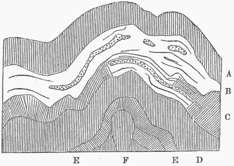
Captain Sulivan states, that in some of the strata the cleavage "in every part, however much twisted, was perpendicular to the horizon;" in others "it was perpendicular to every curve." I have never myself seen an instance of this structure, and I believe it is a new and interesting case. The remaining facts which I have to give refer entirely to the structure of the ranges, composed of quartz rock. In crossing the eastern island in a N.N.W. and S.S.E. direction, in a line intersecting the head of Berkeley Sound, we find north of it several low, parallel, interrupted, east and west ranges, with their strata all dipping a little west of south, at angles varying between 20° and 40°. South of Berkeley Sound the first range we come to is a short one, rising like all the others through the clay-slate formation: the strata near the summit of the principal hill are most regularly arched, with a curvature of 28° in the line of our imaginary section, and of from 14° to 16° in the line of the ridge: on the summit itself they are horizontal. A regular, flat-topped, oval dome (of which a section is here given) has thus been produced. A valley having been hollowed out near the summit, a very curious scene of natural architecture is presented, which excited the utmost astonishment in the old voyager Dom Pernetti.1 At the northern and southern base of this hill, the strata, instead of being, as near the summit, dome-shaped, dip directly inwards at angles of 40° and 50°: I have little doubt, from what I saw in other places, that these strata form parts (as shown by the dotted lines in the section) of outwardly bulging
2.
Dome-shaped hill of quartz, with strata dipping inwards at both the northern and southern base.
1 Pernety 1769. A book in the Beagle library.
[page] 272
flexures, produced apparently by the weight of the superincumbent mass on the lower part when in a pasty state.
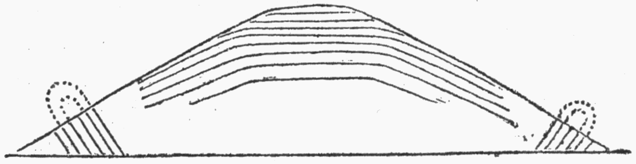
Proceeding in our southern course, a second short east and west range is met with, formed of three principal hills, of which the first (960 feet high) is anticlinal with a broken summit. The second hill is also anticlinal, with horizontal strata on its broad summit, showing traces of curvature towards the edges: the inclination is rather greater on the south than on the north side. Between this second and third hill there is an anticlinal hillock, the strata on its south side dipping at an angle of 59°, and its summit folded as represented in the diagram.
3.
Hillock of quartz with summit of axis-plane thrown over to the south.
We here see that the upper part of the axis-plane, to use a convenient term of the Professors Rogers, has been pushed over to the south. Throughout the third hill the strata at first appear all conformable, dipping from 50° to 55° N. by E.; but on examination I found a small portion, only fifty yards across in the line of the dip, inclined at an angle of 26° southward; and the tips of the adjoining beds were, as represented in the diagram, abruptly arched. Hence this hill has been formed by a mass of strata doubled on themselves, with the axis-plane thrown quite over to the south, as was the case with the upper part alone in the above-mentioned hillock.
4.
Strata of quartz dipping 50° to 55° north, with a fold in the middle, only fifty yards across.
I have described this hill more particularly on account of a curious appearance presented by the arched parts of the strata. The arching has been so abrupt, that in some loose fragments, presenting a natural section, the radius of the curve is seen to be only seven feet. The end section of one such fragment, twelve feet in length, is accurately given in the following woodcut (No. 5), but allowance must be made for a little displacement from an open fissure crossing it. In this case the convex or outer and exposed surface is remarkably even and smooth; it is traversed in the line of the axis of curvature by numerous parallel veins, from the tenth to the twentieth of an inch in thickness, and from half an inch to two inches apart from each other: these often thin out at both ends, but where one thins out, another commences either a little above or below. The veins are partially filled by transverse threads of quartz very
5.
Open fissure.
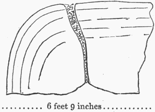
6 feet 9 inches
Base of an arched fragment of quartz.
[page] 273
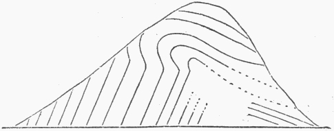
imperfectly crystallized. The quartz-rock must obviously have been in a pasty condition, when it suffered without fracture such abrupt curvatures; and it was impossible to examine these veins without recognising in them the effects of the stretching, and in the fibres or imperfect crystals of quartz, the adhesive nature of the ductile mass*. This hill, as well as the two others in the range, show traces of a quâquâversal or dome-shaped stratification; and we can thus understand the occurrence of some few veins at right angles to those numerous ones in the line of the principal curvature; for there must have been some stretching in two directions. I may add that the arched strata in the more regularly dome-shaped hill before described (No. 2), were intersected by a rectangular network of similar veins, almost equally numerous in both directions. All these greatly arched masses of quartz are very brittle.
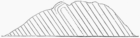
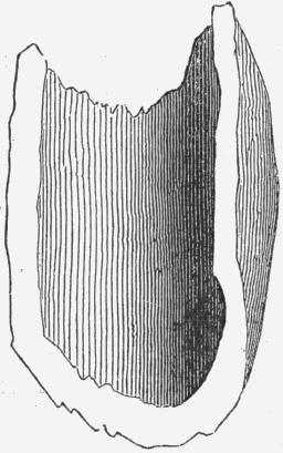
Referring once again to the fragment last figured (No. 5), it is seen to be divided by interrupted lines of stratification, concentric with the outer and convex and now accidentally exposed surface, but firmly united together. Captain Sulivan however found in another place innumerable similar fragments, in which the concentric layers were separate, so that the ground was strewed with gigantic semi-cylinders of quartz, like draining or ridge tiles; he measured one, represented in the diagram annexed (No. 6) and found it twenty feet in length, with a nearly regular diameter of twelve feet. In this instance the edges or rim on both sides are of equal thickness; but in some other cases, whilst the rim on one side was two feet thick, on the other it thinned off to a knife-edge, evidently in consequence of the unequal pressure it had undergone.
6.
Crossing a wide valley of slate and sandstone we come to the chief mountain-axis of the island, varying from 1500 to 2500 feet in height, and running nearly east and west. The strata on its northern flank dip northward; on the summit, which is from one to two miles broad, they are horizontal; on its southern side they are almost vertical with a southerly dip, and with their summits close to the horizontal beds abruptly arched; so that in this main range we have the same peculiar form of elevation, so common in all the smaller hills. At the southern base the strata were in some places folded in the
* In a paper by M. Elie de Beaumont1 read before the Soc. Philomathique, May 1839 (L'Institut, 1839, p. 161), it is stated that M. Gaudin2 was able to draw out threads of melted quartz: M. Gaudin also found that quartz (differently from alumina) retained its viscidity for some time when cooling,—a fact to be borne in mind when we attempt to account for the remarkable flexures which nearly all the quartzose ranges in this island, and likewise in many other parts of the world, have undergone.
1 Jean Baptiste Armand Louis Léonce Elie de Beaumont (1798-1874), French mining engineer and geologist. Élie de Beaumont 1839.
2 Charles Théophile Gaudin (1822-1866), Swiss palaeobotanist.
[page] 274
shape of upright arched gateways. I may mention that fifteen miles to the westward, at the foot of this same range, I found two hillocks of quartz only twenty yards apart, with the strata dipping at exactly the same angle of 40° to S.S.W., and therefore apparently quite conformable; but on close inspection the ends of the beds on the inner side of one hillock were seen to be arched in such a manner, as to show that they had been doubled on themselves, with the axis-plane inclined at an angle of 40°.
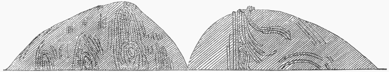
A wide undulatory district of slate and sandstone extends southward of the main range; but on the coast, Captain Sulivan again found two east and west quartz ranges: one of these is transversely intersected by a creek (near Port FitzRoy), and two good sections, a hundred feet in height, are exposed. These are given in the following diagram on account of the complexity of the curvatures, almost resembling those produced by the mingling together of two viscid fluids; and because in crossing the country any one would be apt to think that the dome-formed hills had been produced by single impulses from below, whereas we now see that perpendicularly beneath one dome, another may lie hidden in the solid rock*.
7.
I will not take up the time of the Society by giving any further details on the geology of these islands; nor would the foregoing account have been worth communicating, had it not been for the interest which is justly taken in ancient fossils coming from a very distant quarter of the world.
* It is singular in how many points the old quartz-rock of Anglesea, as described by Professor Henslow in his admirable paper in the Cambridge Phil. Trans. (vol. i. p. 359), agrees with that of the Falkland Islands. The quartz of Anglesea is granule-crystalline, and contains white earthy spots and a little mica; it passes insensibly into an overlying chloritic schist, and this again into clay-slate. The strata have been in a pasty condition, and have been singularly curved: they strike in the same direction with the laminæ of the overlying slates, but their average inclination is less.