[scroll up to see introductory matter]
October 10th —
3265 Trachytic cellular lava frequent large Crystals of glassy Feldspar — commonest kinds low down
3266 Base (Black grey) more abundant (olivine?)
267 do. with scarcely any Crystals
268 Compact Lava with many small Cryst of glassy Feldspar Basis finely Crystalline: — both latter more central parts
269 Finely & highly cellular Trachytic Lava with many Cryst of glassy Feldspar: outer surface bright red glassy cinders.
270 do. with imbedded fragment of altered granites
71, 272, 273) imbedded fragment of do. varieties coarser & finer grained. quartz Cryt. generally visible : Mica changed into glassy minerals — some perhaps Syenite:
274 do — perhaps part of Quartz or Feldspar Vein
275 Red harsh Claystone base with red earthy particles & glassy Feldspar: generally more of latter & more cellular
276, 277 Light dark greenish brown, semi-indurated Volcanic Sandstone
278 reddish brown, smally cellular Trachyte (Pap)
299 Grey compact do. few Cryst of glassy feld
dyke
Freshwater Bay1 , where we are2 bivouaced is formed <(a)> on its Western side by large circular hill3 with Crater on top, from which the strata dip in folds on all sides — These are of Volcanic Sandstones, — containing in layers
1 Caleta Bucanero (Buccaneer Cove), Isla Santiago (James Island). The general location of Darwin's camp site is 0°10.036'S, 90°49.468'W
2 The fact that Darwin used the present tense indicates that he wrote these pages about Santiago (James) on land rather than waiting until he was back on board the Beagle.
3 Cerro Cowan, Isla Santiago (James Island). 0°10.656'S, 90°49.798'W
[Notes to 716 (1)r]
(a) This is the principal & largest one in the neighbourhead & highest.
[This sentence refers to the "vertical masses" on 717 (2)r]
These columns project. — Infiltration hypothesis inadmissible. — Apparently currents longitudinal to Cone — The stratification does not always correspond, though generally to the sides. —
— numerous angular & semi-rounded fragments of Lava: I here saw from the boat that there 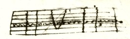 were alternations in vertical
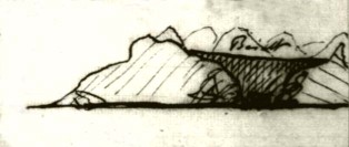
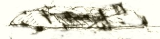
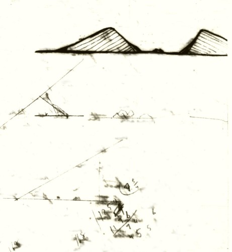
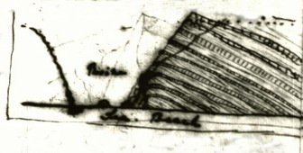
 columns masses: [small sketch]. The strata here were yellowish & apparently finer grained they were crossed by mass of a darker variety, the edge being serrated. — The lines of strata were continuous, as well a layer of pebble: — Some of them were wedge-shaped generally however sides parallel. — The appearance is as if some fluid had altered the rock for an equal distance on each hand. — This may perhaps be the real explanation for in such I generally noticed a fissure: However there were similar fissures traversing the yellow intervening substance without any such effect. — There Besides this Volcanic Mound, which I suppose to have been subaqueous, — there are others of similar constitution: — On the East side of Bay, — a  narrow point is I believe a mere slip out of large Crater [small sketch].1 There is however much confusion in its composition. The exterior diverging kinds are almost solely composed of
 strata layers of coarser & finer red glassy scoriæ, & fragments of Trachytic Lava; & then fine detritus. — The fragments
1 The promontory of Caleta Bucanero (Buccaneer Cove), Isla Santiago (James Island). 0°09.914'S 90°49.605'W
Mr Chaffers Observations1
On Bindloe's Isd 2 there is a Crater of soft Volcanic Sandstones.3 at a height of 300 ft he extracted some marine shells from it ([blank]) fragments of oysters were abundant. — Here was some [true] Trachyte, but the commonest is a jet black glassy scoriæ, which from its form must have been singularly liquid. (— 3286). — Tower Isd 4 is low & horizontally stratified & without Crater: consists of very cellular Lava — of a grey color apparently minutely Trachytic. — (3287) Abingdon Isd5 Consists chiefly of smally cellular reddish Brown Lava, abounding with very large & numerous Cryst of glassy Feldspar. — <<(3288)>> (Also Sandstone Crater. — 6 There is other variety however, more compact almost composed of less fractured Cryst glassy Feldspar angular vesicular <<(3289)>> (cavities. — In the former the appearance = singularly that of imbedded fragments
Indefatigable Island7 very little Bare Lava
Barrington8 Tampoco [neither]. —
Culpepper9 Wenams10
1 Beagle surveyor Edward Main Chaffers visited Islas Marchena (Bindloe Island), Genovesa (Tower Island) and Pinta (Abingdon Island) between 8-19 October. The earliest Darwin could have written the notes on page 717 (2)v was therefore 19 October, when Chaffers returned to the Beagle.
2 Isla Marchena.
3 Punta Espejo on the eastern side of Isla Marchena (Bindloe Island).
4 Isla Genovesa. Chaffers most likely landed on the northern side of the island.
5 Isla Pinta.
6 Tuff crater near Cabo Ibbetson, south-eastern side of Isla Pinta.
7 Isla Santa Cruz.
8 Isla Santa Fé.
9 Isla Darwin.
10 Isla Wolf.
are scarcely at all agglutinated. — Yet in places thin layers of pumiceous dust consolidated & stratified led me to presume they were of subaqueous origin. — I believe the terrestrial origin is certain from a layer of small rounded particles of cinders abounding with Bulimi1 in an extreme state of decomposition. In this mass are some small Lava streams. One point is rather curious. — The coast & a ravine gives two sections at rt ∠s of a minor point of eruption. — On the beach there are two or three <<worn>> paps of Trachytic Lava, slightly cellular of a brownish color . — (3278). One of these at the angle of the sections is about 15 ft high & joins on to them a diminutive streams of Lava. ![]() [small sketch] These first head <<slightly>> downwards, then upward & then again continuing downward. — showing their course over rim of Crater. — Above these there are about 6 more, which are not now joined to the column of Lava, such having been removed. — These streams are as I have said [
[small sketch] These first head <<slightly>> downwards, then upward & then again continuing downward. — showing their course over rim of Crater. — Above these there are about 6 more, which are not now joined to the column of Lava, such having been removed. — These streams are as I have said [most] diminutive. Upwards their length is only 10-20 15 yard downward 60-80. These [traverse] upwards & down It must be remembered, this little eruption took place on the slope of a Crater. — The thickness of the streams correspond to their
1 Bulimulus land snail shells.
718 (3)v [blank]
lengths. — I measured They all consist of a highly cellular greyish base abounding with large & numerous Crystals of fractured glassy feldspar. — The outer edges surfaces for about 2-4 inches is converted into bright red scoriæ of a glassy texture & friable 3269. — <<small>> such <<fragments of>> scoriæ separate the streams.1 I measured one stream, of which the Trachytic dark part was 8 inches, to which may be added 6 inches for the superficial red cindery matter giving 14 inches for that thickness, & this for whole extent. — Another was altogether only 8 inches. — The rest from one to three feet thick. — The loose intervening scoriæ, being of rather greater thickness. — This Trachytic Lava is remarkable by containing very many fragments of altered rocks, which clearly have been Granites & Syenites (3270:71:72:73). The <<glassy>> substance into which the Mica is converted is remarkable. — The Fragment apparently has been part of a former vein (3274). — It will be remarked, that the Crystals of glassy feldspar are not enlarged by [bubbles] neither are the Granitic fragments, which would induce one to believe all the glassy Feldspar, which is similar to that of the Granites, are imbedded. — A conclusion, which
1 This formation was named by the authors, "Darwin's layer cake." 0°10.033'S, 90°49.567'W. See: Estes G., Grant K. T., and Grant, P. 2000. Darwin in Galápagos: His Footsteps through the Archipelago. Notes and Records of the Royal Society of London. 54(3): 343-368.
719 (4)v [blank]
I do not believe, from reasons which will be given. — I should suppose all these streams Lavas have been ejected at one eruption epoch of activity: small intervals of time separating these streams. — It is remarkable to find Trachytic Lava. — one supposed to have little fluidity, forming streams 6 & 8 inches thick. — The pile of scoriæ is traversed in many by great broard dykes, running for distances vertical & several yards thick, composed of gry compact Trachyte, with only few Crystals: side & certain spots more cellular (3299).1 — The eruption of such matter doubtless has formed the small point of ejection. — In one part of the grand pile of scoriæ & fragments. — There were very many large pieces of a harsh red Claystone base, more or less vesicular & containing more or less Crysts of glassy Feldspar Speci & small bright red earthy specks. — Specimen shows the two cases in lesser extreme (3275). — I did not reach any stream of this rock, but it must be very abundant. — In central & rather lower part of the promontory, which I believe to have been bosom of Crater. There is a mass about 200 ft thick of a quite compact, greenish or blackish
1 A mistake for 3279.
720 (5) verso
like 3267 3268 [marginal comment to the first line of 721 (6)r]
grey Trachyte with few Cryst of glassy Feldspar: Its lower surface to the thickness about 2 ft, where it lies of the Volcanic detritus, is cemented fragments of slightly & finely cellular do. rock, but containing larger & more abundant Crysts of glassy Feldspar. — This mass thins out on the sides. — On the South side the whole Volcanic hill is encased by thinly stratified dark greenish brown, light, not hard Volcanic Sandstone (3276:77) Contains few large, nearly ∠r fragments of Lava: is highly pisolitic in places in its structure. — overlies without any passage the red detritus & scoriæ. — It covers the compact Trachyte in former Crater, & folds over whole side of Hill. — From its regular stratification & distinctness & compactness I thought I subaqueous: till I noticed arguments applied to origin of the <<inferior>> red detritus. Has it flowed as Mud, or could ashes, when they fall be so hardened by rain. — The former has analogy of Albermale Isd in support. — yet this whole substance seems to unite so continuously [with] the bases of the different Volcanic Mountains, as to lead one to suspect the latter argument. — Anyhow the sudden change in nature & color of this encasement is remarkable. —
(3.8 of mile diameter of Craters)
A north mound of Albermale Island
(800 ![]() [small sketch])
[small sketch])
Crater about 600 ft. very perfect. all sandstone
page in pencil.
Stream — Have burst from several small Craters at foot of central Trachytic mass of highest hills & Craters. — Consists of vesicular Greystones such as (3280) which abounds in a very remarkable degree, with quantities of olivine. is generally very Vesicular & sometimes rather a Blacker color (3281). — The Basis is much the same as in Central Trachytes, the olivine here replacing glassy Feldspar. — Its surface is smoother than the Basalt of Chatham Isd. — Yet many great fissures. — Surface ringed (like Cow-dung), which often take form of cables; folds in a runged drape & branches with rough bark. In this Island we have thus olivine Lava as the latest, whilst in Albermale that of Trachyte. — near to the sea, it has burst through an ancient crater, (composed of igneo-cemented red glassy scoriæ & greystone Lavas) filled up Crater & left only 2 pieces, which stand in front of each other.1 —
There is here a Beach, of large rounded cobble stones above present level of tides, although only a few feet. —
1 These kipukas are prominent features in Bahía James (James Bay), Isla Santiago (James Island). 0°13.877'S 90°50.761'W
722 (8)v [blank]
Travelling inwards in a SE line, where beyond the influence of the Sandstone Craters. All the rock is highly cellular blackish grey Trachyte, abounding with glassy Feldspar: (3265), parts are more compact (3266).— More in the interior: compact varieties are common, containing more or less numerous Crysts of glassy Feldspar. — Here I found a very perfect Crater: well wooded but entire & large.1 — Generally it may be remarked that the more cellular Trachyte contains the largest & mor perhaps more numerous Crysts of Feldspar. — This is the reason, I do not believe they preexisted. — Circumstances determine their size & [illeg] numbers. Specimens of more compact kinds 3267:32682
October 11th
3280. Black grey Lava abounding with Olivine, [basis] same as Trachyte, latter mineral
replaces glassy Feldspar.
3281 — do. Blacker more cellular. — Both very recent stream.
3282. Yellowish-brown Sandstone Resinous — Black glassy patches
3283 — do. compact Volcanic fine grained Sandstone.
At Puerto Grande.3 — There is stream of Lava 4 miles broard & 1-2 wide, — very recent, without vegetation. — surface glassy — yet covered by other
1 Cerro Pelado, Jaboncillos, Isla Santiago (James Island). 0°12.365'S 90°47.040'W.
2 For a discussion of these 4 geological specimens and the conclusions Darwin drew from them, see Herbert, S., Gibson, S., Norman, D., Geist, D., Estes, G., Grant, T. and Miles, A. 2009. Into the Field Again: Re-examining Charles Darwin's 1825 Geological Work on Isa Santiago (James Island) in the Galápagos Archipelago. Earth Sciences History 28(1): 1-31 and Grant, K.T. and Estes, G. B. 2009. Darwin in Galápagos: Footsteps to a New World. Princeton University Press.
3 Bahía James (James Bay), Isla Santiago (James Island).
[Notes to 723 (7)r]
& little Fissures which have acted as Fumaroles sides being white. — Although this appears as but of the other day. — It is crossed by a browner Lava. — which <<even>> from size of trees growing in its very margin must be many years old. — A terrapin was caught some years since with its shell appearing to have been burnt years before. The inhabitants believe this the effect of Volcanic fire. — I rather accidental fire in wood
Puerto Grande
To the South of this stream & a mile & 1/2 from the Beach, there is a Salina which is worked for Salt.1 — It occurs in a Crater — about 1/3 mile in diameter nearly circular <<& most beautifully regular>> sides very steep. — Brim rather higher on one half than other, — but not broken down. — where highest about 400 ft deep. — This is much deeper than the surrounding country. — Indeed on SE side ancient olivine Lava streams have nearly brought country up to level of the brink. — The whole upper part of rim is composed of compact, glassy, yellowish brown Volcanic Sandstone. — some of which is semi-Resinous in its nature & contains small glassy patches (3282-283). — <<Like in Chatham Island>> I do not doubt is of subaqueous origin. — although lower down there is much of a greenish darker brown. — Pisolitic Sandstones ( like that of yesterday2 only rather more compact. — In all parts few fragments of Lava. — These composed 2/3 of descent. — latter third of whole circumference is very precipitous & composed of olivine Greystone. — It appears as if whole bottom
1 Mina de Sal (Salt mine crater), Isla Santiago (James Island). 0°14.414'S 90°50.169'W
2 The fact that Darwin used the word 'yesterday' supports the idea that he wrote this page on 11 October. He would have seen 'pisolitic standstone' at Caleta Bucanero (Buccaneer Cove) on 10 October.
 [sketch]
[This sentence is linked to second to last sentence of 725 (10)r]
Mud either hardening in the air or flowing in the sea — perhaps would not essentially differ
of Crater, composed of Solid Lava had been blown up & great emission of ashes beneath water had formed the upper 2/3 of unbroken rim. — at base of Crater Lake surrounded by green margin of Saliferous Plants. — Lake about 6-12 inches deep — never drys. rests on pure Salt. — There are three or four distinct layers about 3 inches thick, separated by impure Salt. — the whole resting on such — I have Water for analysis. — Sides of lake deep mud. — Some Crystals of the Salt splendid cubes, sides nearly 2 inches long. — This salina is on the Projecting Headland South of Puerto Grande. — There is another higher & similarly constituted hill <<said to be>> also with Crater containing Salina.1 — And another more lofty mountain said to have dry Crater,2 Entirely constituted of the Volcanic Sandstone. — These where they enter the sea from compactness & stratification & especially <<present>> position I cannot doubt are subaqueous origin. — Yet on slopes of this mountain <<& indeed generally>> the nature precisely resembles those which I have believed to be sub-aerial. It is a difficult point. — The slopes of this mountain are really extraordinary from the great extent & perfect smoothness of the folding layers of this substance. <(a)> — It [continued on 725 (10)v]
1 Salina Escondida, Isla Santiago (James Island). 0°16.581'S 90°50.454'W
2 Pan de Azucar, Isla Santiago (James Island). 0°15.556'S 90°50.897'W
[continuation of last sentence on 725 (10)r]
precisely resembles a plastered floor. — Small branching fissures from drying — Large extents. — Mantle round the base. [2 small sketches]
Galapagos Isds October 1835
[The following pages consist of sheets folded in half, to make four pages. Size of each page is 16 x 20 cm.]
Hoods Island appears a mass of Lava.1 <<a very great number of small Craters>>
Sept. 16th N. West end of Chatham Isd :2 surface large angular fragment of black basaltic lava = <<crystalline (3239) >> vesicular in bands: surface also reddish highly vesicular <<in fragments>>. — [Only] <<& lowest>> structure consisted of angular & some rounded of vesicular & semi-compact <<(3239)>> Lava cementing a <<very >> hard Calcareous sand composed of broken shells — a few perfect ones (V specimen):3 Lime has percolated some of the most porous Lavas. — ∴ elevation recent & subaqueous Lavas. Very shoal sea.—
Outlying rock ![]() [small sketch] columns, in parts much olivine. — Sand <<on beach>> either composed of this or of minute bits of Shells: N.B. Calc: Tufa
[small sketch] columns, in parts much olivine. — Sand <<on beach>> either composed of this or of minute bits of Shells: N.B. Calc: Tufa
NE end of Island 18th . — Beds of Black or grey Lava: [survace] partially smoothed over with a Calcareous Tufa the interstices of Lava are so filled up4 :
1 This description is not an accurate portrayal of Isla Española (Hood Island). Isla Española (Hood Island) is low and vegetated with a few highly eroded craters that look like rounded hills. When the Beagle first entered the archipelago on 15 September Darwin would have seen both San Cristóbal (Chatham Island) and Isla Española (Hood Island) from afar. San Cristóbal (Chatham Island) has raw lava fields and large numbers of craters and Darwin may have been visualizing San Cristóbal (Chatham Island) when he wrote this sentence.
2 Actually the southwestern end of San Cristóbal (Chatham Island).
3 Cerro Tijeretas, San Cristóbal (Chatham Island). 0°53.290'S 89°36.487'W
4 Bahia Tortuga de Agua Dulce (Terrapin Road), San Cristóbal (Chatham Island). 0°42.150'S, 89°36.417'W
N.B. Calc: Tufa] added pencil.
726 (1)v
[notes to 727 (2)r]
have their
No lava in the folds which are now exposed.
About a league inland detatched small hills, in part detatched or [blended] joined with a central mass1 : ["have their" on 726 (1)v] Strata dipping from <<a common>> centre on all sides at about 40°. — Consist of lower bed in crumbling state & concretionary structure of 3220:21: (a) a compact soft not hard, yellow resinous substance; containing covered by more compact homogeneous (b) 3223-3224.
["No lava in the folds which are now exposed" on 726 (1)v]
— Contain occasional fragments of Lava. — Central mass amorphous, dyke in the barrier. — Evidently above the Basaltic lava. — A <<submarine>> Volcano after having poured out Lava has ejected much Ashes, <<or rather mud>> which having collected round its base & lastly filled up <<from deposition>> the Crater: [sign of]— There are other similar hills <<towards very extremes>>. — A point in front of Kicker rock appears very same formation. — Also many Black Basaltic cones are at no great distance : — Top of Kicker rock & opposite point, appear once to have formed a plain, if so horizontal upheaval have equaled [space left blank] ft. —
1 Pan de Azucar, San Cristóbal (Chatham Island). 0°43.424'S, 89°21.337'W
[Notes to 727 (2)r]
(a) Crystals — & a little calcareous matter. — I presume is a sedimentary, but most curious substance. Parallel ridges having appearance of dykes consist which traverse whole mountain consists of a more compact kind <<which on sides is not very distinct from Strata>>. — (3222.) — This substance is of great thickness, some 100 ft covered by 30 - 40 ft of harsh, brittle not hard, earthy Volcanic Sandstone, more or less coarse. (3223:3224) . — In centre of the Crater, the highest part of hill is chiefly composed of a paler coarse (white patches) earthy Sandstone (3225). — Kicker rock & point in front appear same formation: The sandstone however is hard fine grained compact, — containing minute patches of the Resinous substance (3226). Is traversed by dykes. — Appears remains of other Crater: Deposits from which have produced the Kicker plains. — As I have said Kicker rock is thus formed Cause of level top. I do not understand [contains] [probably] parts of old Volcano —
Chatham Isd
to SW of this Crater there a undulating district of a black rugged appearance, streamed over with Craters, which must strikingly remind me of the Iron foundaries in Staffordshire & Shropshire. — I counted in space of a few miles upwards of 60. — For an account V Small note Book1
(3234). Is specimens of the common Cryst but highly cellular Lava, with olivine &c
Again to the SW of this Craterized district there is a high hill, which forms a point (Finger Hill)2 & is nearly opposite to Kicker hill Rock. — 3 Round its base the more modern Lavas just described have flowed: It is in constitution closely allied to (Crater P 2).—4
1 This is a reference to pages 19b-33b of Darwin's Galapagos notebook. The earliest that Darwin could have written the entries in his field notebook is 22 September. This suggests that page 728 (3) of CUL-DAR37 was written on or after the 22nd .
2 Cerro Brujo, Isla San Cristóbal (Chatham Island). 0°45.600'S, 89°27.552'W
3 Leon Dormido. 0°46.644'S, 89°31.168'W
4 The crater described on page 2 is Pan de Azucar, Isla San Cristóbal (Chatham Island).
[Notes to 728 (3)r]
The very NE point of Isd is similarly constituted.<<Kings Specimens>>1
1 Cerro Pitt (Mount Pitt), Isla San Cristóbal (Chatham Island).. 0°43.058'S, 89°14.882'W. Midshipman Philip Gidley King most likely landed here, and collected specimens, on September 21 or 22 while Darwin was camped at the Craterized district.
Appear generally amorphous composed of Sedimentary Rocks. 3226 & 3238. Where foreign pebbles [particles] of Obsidian Pumice broken Crysts are <(a)> imbedded in a brown very compact almost [conch. part]: which contains many well rounded large pebbles & [angular] of vesicular or compact Lava. Is compact & hard. — Traversed by dykes (which in the one spot) thinned slightly downwards of ditto, but a Trace more compact substance (very similar 3236-3237). Till I hammered it, could not believe it was not true Basaltic dyke. — The mountain has then been fissure filled up. The mountain, again, subsequently to upheaval, has been fissured widely in same direction & now only filled with loose fragments: if very compact nature of stone & refilled fissure did not point out subaqueous nature the well rounded form of numerous pebbles would
[Notes to 729 (4)r]
(a) which passes into the Resinous substance mentioned at P. 2.1
Kicker 407 ft. Finger Hill 560 ft. Mount Pitt being 800. Has sea covered submarine arch mud [interior] of arches Highlands & [oldest] hills Intermediate district Craterized do.
1 Pan de Azucar, Isla San Cristóbal (Chatham Island).
— do so. Generally this stone is amorphous; but in other spots, a Crater formed dip at high angle, <<more than>> 50°— can be clearly be perceived: This Hill within recent period, in place of Peninsula, has been island — The sea has nearly cut the mountain in two, on the present inland side. — We see, a funnel shaped mass of black [ Augitic Crystaline] compact Basalt. <<with (red Olivine?)>> (3235) compact, owing to its subaqueous origin, — covered by thick stratum of more vesicular nature: The edges of the funnel spread out & cover on each side the sandstone: the lower part being vesicular & coarse, nearly like the upper part. We have now seen four points, very similarly composed, which have clearly been
 [small sketch1 ]
1 Cerro Brujo, Isla San Cristóbal (Chatham Island).
subaqueous volcanos: distinct & older than the Craterized district, or I may say phlægræan fields. These are the highest points in the neighboring country1 . — I am can well believe a horizontal upheaval of whole island would produce this whole story. — Yet would not an upheaval in each wh point more naturally explain high dip of the Sandstones. — Certainly the sandstone P 2 looked as if horizontally (or nearly so) stratified. — The fact is in accordance with Mr Lyells view of repeated till in same point & my supposed observation in the Cordilleras. — I am cautious for if so there [would] the Craters of Elevation. —
1 The four high points mentioned are Leon Dormido (Kicker Rock), Cerro Brujo (Finger Hill), Pan de Azucar (Sugar Loaf) and Cerro Pitt (Mount Pitt).
(Highest land above1700 ft.-)
Charles Isd
Hoods Isd swarm with Craters. Nearer 14 than 800.
The highest hill2 is 2000 1800 ft, a much broken Crater: escarpement red glassy Scoriæ. — From this point I counted from 35-40 hills, in <<summit of>> all of which there is a more or less perfect circular depression. — 3 In the lower parts there are Basaltic & Greystone vesicular Lavas: Generally the whole is covered with Vegetation & there appears to have been no recent stream. — <<Mr Chaffers informs>> all The small Islands around Charles have all Craters. — Champion Isd is a much weathered Craters, partially composed of Sandstone, containing marine Shells4 . — From the highest point 400-500 ft, Mr Chaffers brought me a Murrex. — Has this been a horizontal upheaval. — Everything shows
1 Small page number is absent. Should be #7.
2 Cerro Pajas (Round Hill), Isla Floreana (Charles Island). 1°17.732'S, 90°27.363'W
3 As Darwin ascended this hill on 27 September, this page must have been written on or after the 27th , perhaps on the way to Isla Isabela (Albemarle Island).
4 Isla Campeón (Champion Island) is not a tuff crater, but rather a scoria crater. Darwin was most likely referring to neighboring Isla Enderby (Enderby Island).
[small pencil sketch]![]()
[continues last line of 733r] Volcano, for near the shore there is no bottom with 160 fathoms: craterized district level:
Charles Isd
that in place of these Islands being formed by pile of poured out matter, there has been upheaval extending over these different Isds . — Both on Chatham & Charles <<there is>> a beach <<rounded lava rocks>> above action of present surf. Pres Sometimes present
![]() [small sketch] clear double line. The height of this beach appears, I think slightly to differ, where most, probably not more than 15 ft above highest wash. — // Brattle crater subaqueous, strata about 45, — Very stratified. SW end of Albermale Isd , black Lava streams at west end. Large round mountain from <<top of>> which immense streams of black Lava can be traced. Low country beneath studded with low & very perfect Craters in a more extraordinary manner, even than at Finger point: Here may be considered as flank of one great [sentence continued on 732v]
[small sketch] clear double line. The height of this beach appears, I think slightly to differ, where most, probably not more than 15 ft above highest wash. — // Brattle crater subaqueous, strata about 45, — Very stratified. SW end of Albermale Isd , black Lava streams at west end. Large round mountain from <<top of>> which immense streams of black Lava can be traced. Low country beneath studded with low & very perfect Craters in a more extraordinary manner, even than at Finger point: Here may be considered as flank of one great [sentence continued on 732v]
1 Small page number is absent. Should be # 8.
2 Isla Tortuga. 1°0.581'S, 90°52.430'W
October 1st Albermales [small sketch]
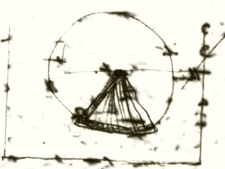
Banks Cove1 is seated in the midst of Craters: Examined the one <<a short distance>> to the south. — 2 Crater Elliptic, longer axis N & S. — length perhaps 3/4 of mile, breath 2/3. — Sides in highest part about 500 ft above base. — open to S. & Seaward. — <<+ +>> An immense stream of Lava from the mountain behind has crossed the mouth poured part of its contents inwards & part towards the sea. — Hence it is seperated by a broad tract of this substance. — <<+ +>> The bottom of crater is a deep lake of very salt water, is little, if at all elevated above the sea.) — In the middle are Three Islands3 , in one of which a small Crater is very evident: — In the whole circumference <<& escarpement>> the rock is Volcanic Sandstone [const] (3249), generally of brown & yellow color not very compact or hard. — some of the lower strata are
1 Caleta Tagus (Tagus Cove), Isla Isabela (Albemarle Island). 0°15.671'S, 91°22.279'W
2 Cráter Beagle (Beagle Crater), Isla Isabela (Albemarle Island). 0°16.826'S, 91°21.162'W
3 There are 6 islands, 3 of which are distinctly larger than the others. The islet with the small crater has been named Chaffers Island. For the names of the other 5 islets see Estes G., Grant K. T., and Grant, P. 2000. Darwin in Galápagos: His Footsteps through the Archipelago. Notes and Records of the Royal Society of London. 54(3):343-368.
however much more so. — In very many parts there is a pisolitic Structure (3250), the balls from size of shot to small bullets, imbedded, formed of thin <<[concentric]>> layers of [finer] mud. — Contains in places, abundant broken Cryst of olivine & glassy Feldspar. — In all parts, very many large & small more or less imperfectly rounded fragments of cellular & very compact Greystone & Basalt, & much vesicular Trachyte. — These pieces are arranged in layers. — I saw some strata, almost entirely composed of such Fragments. — The whole of this grand circle of Sandstone is thinly stratified: all the folds dipping very regularly from angle 25 to 33° to from The centre of Crater. — In no part is there a stream of Lava: But it is manifest, the volcanic eruptions
Banks Cove
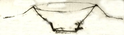
have taken place through such: — The external sides of the Crater slope up regularly at about same angle as the strata. — They are <<longitudinally >> furrowed (or radiated) at very regular distances, from the lip of Crater to base. — [small sketch]
![]()
These longitudinal doons are from 8 to 20 or 40 ft wide, are seperated fr from each other by gullies, — are not formed merely by the excavation of these latter: because the strata of each correspond with the curvature of doons. — <<+ +>> The appearance of the many is that of a plastered (plates cracked & in plates) archway. <<Some of them reach only half way down the hill>> — The gullies between no doubt have been <<+ +>> deepened <<by alluvial action>>. — Higher up, these archways are sometimes
hollow & have there a structure & appearance identical with those Lava of Basalt described at Chatham Isd . — At the very lip of the Crater, there present hoods, more or less hollow. — ![]() [small sketch] Also on the external <<highest part of>> sides
[small sketch] Also on the external <<highest part of>> sides of [larg] of Crater there are numerous gutters. ![]() [small sketch] from 1 to 2 feet wide, formed of the Sandstone, formed as it were by man to conduct a fluid. — There can be no doubt, from this description, but what this has been an <<exclusive>> Mud Volcano: from the ovens edge, the boiling thick mass has poured over in narrow streams. — From evaporation & cooling the upper surface has occassionally hardening, whilst the central has flowed onwards. —
[small sketch] from 1 to 2 feet wide, formed of the Sandstone, formed as it were by man to conduct a fluid. — There can be no doubt, from this description, but what this has been an <<exclusive>> Mud Volcano: from the ovens edge, the boiling thick mass has poured over in narrow streams. — From evaporation & cooling the upper surface has occassionally hardening, whilst the central has flowed onwards. —
It is worthy of remark that in this the highest part the pisolitic structure is well developed. — From the outline of the gutters & archways being preserved so perfect, it is manifest <<this>> matter has flowed over the sides subsequent to in the air. — or removed from the action of the sea. — Yet from the structure of the lowest strata, (their compactness &c &c ) <<which agrees with what has been observed in Chatham Isd>> I feel no doubt they are 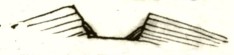 [small sketch] in certain spots, to the height of about <<100->> 150-200 ft. there is a casing of similar Sandstone (abounding with stony fragments) which dips very regularly to the
centre of Crater: From the stone composition of this I have no doubt it is a [giant] subaqueous formation. — It was remarkable how very little any thickening of this strata, although inclined at the high angle of 36°. — in the lower parts, could (if at all) be
perceived. — There are also piles of detritus. —
Hence, probably this was a mud Volcano in the sea: by horizontal upheaval or solely by a [many] of
accumulamud matter was accumulated to the height of 300-400 ft. —
forming an elliptical lagoon Island. — At this period the Volcanic action ceased: the
[covering] detritus was consolidated, & then the whole upheaved to present position & Elevation: — A mud Volcano in the sea, differs in no respect,
greater
Banks Cove
from a Volcano which only on land emits ashes & scoriæ. — I have particularly described this, because I do not recollect having read any description of <<one of>> these [cliffs] : — At Banks Cove, there is the remain of a larger & apparently older Crater, in a much more demolished state: the ship is anchored within. — The converging strata <(a)> are here very fully developed & dip beneath the water, [hence] there is 50 to 100 ft close to the shore: the rock is nearly similar: I noticed in one part of true Crater, the regular decrement in angle of dip, with proportional thickening of the strata, towards the basal margin. — The outline of this Crater has been broken by other large ones
[Notes to 740 (15)r]
(a) The stratification is in parts very highly inclined & most curiously contorted, from <<inferior>> [irregularities] & effects of currents. Section Particular Description
[sketch] 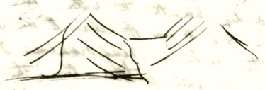
one of which is very perfect, with Salt Lake at bottom. These are partially included, & partially [intersect] the outline. — of the grand & older Crater. — All are composed of the stratified Volcanic Sandstone — In Chatham Isd we have seen such forming the principal mountains: here they are subordinate to a great hill 2000-3000 ft. high, from all parts of which Lava has flowed. — One enormous stream many miles broard, almost entirely destitute of vegetation, I believe I must except two or three Cactuses: interfolds behind & between these [mud] Sandstone Craters: we have
Banks Cove
To the N for many miles has entered the sea. — It is composed of Trachyte, (& in this respect interesting) about 4 feet from the surface, the rock is more compact, than higher up (although specimens do not so well show this) consists of very numerous large Crysts of glassy Feldspar imbedded in irregular vesicular black gry base (3247). — I was surprised to find the Crystal in the very superficies of this sub=Aerial current equally well developed (3248) . — The surface <<of the Lava>> as compared with the Greystone or Basaltic one of Chatham Isd is on a large scale much smoother. — there is not that appearance of large frozen billows, or nearly so many fissures of [contraction]:
On a smaller scale, the surface is excessively rough. — I should compare this to a lake violently agitated by wind, the other to the ocean. — The liquidity must have been more perfect (a fact believed to be uncommon) the general surface is more level: it has flowed through narrower channel & lastly the edges are infinitely thinner: consisting of the more vesicular fragments: & from one to 2 or 3 ft. high. — ["Very", on 742 (17)v Recent as this stream appears to the eye, — it is covered by in one part by a small <<narrow>> black Lava, which has from a minute & perfect Crater on side of mountain. — The great field of Lava, which has separated the basin of the first Sandstone Crater
Banks Cove
from the ocean, also has flowed from the same great Volcanic mass. — The Sandstone Craters must have burst up through streams of subaqueous Lavas of Basalt & Trachyte & we here see the latter overlying these. — Therefore such [lava have alternated.]
[This paragraph in lighter ink] — Albermale Island (greatest of group) consists of as yet1 four grand mounds, 2000-3000 ft high joined by low country, formed of Lava streams & studded with little Craters: — Narborough Island, which has an active Volcano & is more covered with bare Lava than any other we have seen; belongs to this group & is only separated by a narrow arm of the sea: — In Albermale Isd in 2d mound
1 The word "yet" suggests that he wrote this page before seeing Volcán Wolf (Wolf Volcano) further to the north. He would have seen Volcán Wolf (Wolf Volcano) from the Beagle after leaving Tagus Cove on October 2.
[Notes to 744 (19)r]
I believe there are 5 principal mounds (1) (in NW corner) lesser one.1 — (N or S chain) ? Is James Indefatigable Charles2 other parallel line?
1 Volcán Ecuador.
2 Isla San Cristóbal (Chatham Island) is more in line with Isla Santiago (James Island) and Isla Santa Cruz (Indefatigable Island) than is Isla Floreana (Charles Island).
from the south, there was steam issuing from Crater high up. — Near to South West mound, a point Craterized by Cones just like at Chatham, [really] on side of mountain. — 1 for a short distance from the shore no bottom, with 840 ft. // — At Brattle Island large, 2/3 circular Crater of Sandstone, lying close to main Island just like 1st Crater just described [illeg] must once have been: —
[This paragraph in lighter ink] There would appear as seen from west coast 5 principal mounds (& one rather smaller one on NW corner: — (Perhaps other in SE corner???)
1 Punta Cristóbal (Point Cristopher), Isla Isabela (Albemarle Island).
[Notes to 745 (20)r]
(whale 3730 ft (2360) 1 [small sketch2 ] 
Whilst (1) Crater is coated by mud nearly to the bottom which must have flowed in the air. — Crater (2) probably was entirely marine, for its sides are worn into cliffs & much degraded by action of the sea: & as has been mentioned the large [quantity] of [internal] converging strata: In Crater 1, The converging is so small, that perhaps it might have accumulated even anterior to last eruptions. — Yet I do not doubt at last eruption Crater full of Salt Water.
1 Whale Hill is now known as Volcán Darwin (Darwin Volcano), Isla Isabela (Albemarle Island).
2 Sketch of Cráter Beagle (Beagle Crater) (1) and Caleta Tagus (Tagus Cove/Banks Cove) (2) with the word Capt Fitz Roy written above what is now known as Darwin Lake.
[The following pages are single unfolded sheets measuring 20.5 x 25.5 cm. They were written after Darwin left the Galápagos Islands.]
1835 October Galapagos Isds
The archipelago of the Galapagos consists of ten principal Islands; of these — five, namely Albermale, Narborough, James, Indefatigable & Chatham considerably exceed in size the other five, Charles, Hood, Barrington, Bindloes & Abingdon. Besides these <<there>> are several <(a)> insignificant islets. The archipelago covers a space of ocean, extending over 125 miles of Latitude (from 0°.38'N to 1°.27'S) & 140 of Longitude. This space, although not the quantity of land, may be roughly compared to Scicily, conjointly with the Ionian Isles. All the Islands are strictly Volcanic in their nature constitution formation, the whole being composed of Lavas & Volcanic Sandstones. I believe if every Crater throughout the whole group was enumerated, the number would certainly amount to several thousand. Personally I have only visited four of the Islands, namely Charles, Chatham, James & Albermale Isd : I saw however specimens & received notices respecting the others from the various officers employed in the survey. In my description I will commence with the most Southern Isld & so proceed northwards. —
Note (a)
I exclude the small Islands of Culpepper & Wenman, which lie 70 miles to the
Northward, from this measurement of the group. —
1835 October Galapagos Isds
<(a)> The archipelago of the Galapagos Isds consists of 10 principal Isds which are scattered over a space equalling in extent the whole of Scicily & the Ionian Isles. — They are strictly Volcanic being entirely composed of Lavas & Volcanic sandstone, the latter not being very abundant. & only in the. I will begin with the description of the most Southern Islands & so proceed northwards.
<Charles Isd > — The highest hill is 1800 ft. its summit is formed out of the remains of a Crater. this escarpment consists of red glassy scoriæ cemented united together. — From this point I counted in different parts of the Island (although, only [words illeg] [its] diameter, the figure being nearly circular, is only 8 miles), from 35 <<39>> 40 hills, in the summit of all of which there is a more or less perfectly circular depression. — In the lower parts the Lavas are Basalts, or Greystones & more or less Vesicular. —
Mr Stokes found on the SW point <<& in another place>> some streams of bare & rugged Lava. With
39] added pencil.
I only personally landed on four Isds Charles, Chatham, Albermale & James Isd . — I saw specimens & received notices respecting the others from various officers. — (B) I should suppose in the whole group there must be several thousand Craters sufficiently perfect to be recognized as such
(B) I...as such] added pencil.
1835 Octob: Galapagos Isd
<Charles Isd > these <<two>> exceptions, the Isld is covered with Vegetation & there are no signs of very recent Violence. — On the North side of the Island I noticed in many places a beach of large rounded Rocks, which appeared to me decidedly to be quite beyond the reach of the Surf at the present level. — In one spot, there was a low double ![]() cliff & on the top of the both a bank of such pebbles. [small sketch] . Perhaps this raised beach may be, when highest, 15 ft above the line of
cliff & on the top of the both a bank of such pebbles. [small sketch] . Perhaps this raised beach may be, when highest, 15 ft above the line of highest any present action. — 1 All the neighbouring small Isds either consist solely of a Crater or a hill surmounted with one. — The walls are generally much broken down. — Mr Chaffers <3291> brought me from Champion Isd a fossil shell: which he extracted from Volcanic Sandstone at the height of 400-500 ft. — The whole hill being composed of this substance.2
— <Hoods Isd .> Is studded over with small Craters: in many parts, there are black naked streams of Lava. — Its height is 640 ft. — 3
1 Between Rada Black Beach (Black Beach) and Punta Daylight (Point Daylight), Isla Floreana (Charles Island).
2 Darwin's description more closely matches Isla Enderby (Enderby Island). Neighbouring Isla Campeón (Champion Island) is a low scoria crater.
3 The craters on Isla Española (Hood Island) are extremely worn and eroded. There are no recent lava flows.
[The following pages consist of sheets folded in half, to make four pages. Size of each page is 20.5 x 25.5 cm.]
1835 Octob Galapagos Isds
<Chatham Isd > The highest land is about 1700 ft. — The South side is steep & appears to consist entirely of Lava covered with Vegetation. — At the Eastern extremity & North shore, there are <(a)> some mounds of Volcanic Sandstones surmounted by a Crater. — a short distance to the West, I examined a smaller one. — 1 Having passed over a <<league of a>> level district of Basalt & Greystone, smoothed over & the interstices filled up by Calcareous Tufa, I came to some small hills in parts detached, <<in others>> joined to a central mass. — The strata dipped <<away>> from this centre on all sides with much regularity at about an angle of 40°. — In the external hills the lower strata, to the thickness of several hundred feet [stone] composed of a very singular stone; it is brownish yellow, compact, yet softish, containing some little Calcareous matter & of an imperfectly resinous appearance <3220>. — The whole is divided by a smally concretionary structure & hence is very crumbling. <3221>
1 Pan de Azucar, Isla San Cristóbal (Chatham Island).
[Notes to 749 (3)r]
(a) Specimens of the semi-resinous kind, like (32 36…38) — Height of this Hill 800 ft.
1835 Octob Galapagos
<Chatham> This is covered by a stratified mass from 30-40 ft thick of a coarse harsh brittle brown Volcanic Sandstone. — <3223> <3224> Both kinds contain occasional fragments of Lava. — In the former stone there was a remarkable appearance resemblance to dykes of hard stone rock. These however when examined closely were hard to distinguish from surrounding substance. — They consist of the very same semi-resinous substance, only a trifle more compact. — <3222> I suppose these must be explained, by what Mr Scrope1 describes as a shrinking of the rock & subsequent secretion <<from the>> of still partially liquid surrounding matter. — The central mass is a paler & coarser soft Volcanic Sandstone with white specks <3225>; its structure is amorphous. — This substance appears to occupy the hollow of the Crater: Both it & the external parts have been much wasted away. The latter only existing as distinct hills. — The sea, at the same time that the lower lavas were smoothed over with Calcareous Tufa probably effected this. —
1 George Poulett Scrope.
1835 Octob Galapagos Isds
<Chatham Id>
The whole mound is superimposed on the Basalts; in no part we have streams of Lava & only a few fragments. I cannot doubt that the semi-Resinous stone [is] a subaqueous sedimentary deposit. — The upper sandstone may <<either be of similar origin or>> have flowed as mud subsequently to the Crater having emerged from beneath the Sea. — I mention the latter supposition because a similar stone will presently be shown thus to have been formed. —
A few miles to the west there is a hill1 520 ft high forming a bold point in front of the Kicker rock & which is very nearly related in its structure to the first last Crater. — It is a broard & large mass, the whole (excepting centre) is composed of a compact <3226> <3238>, with almost a conchoidal fracture <(a)> slightly [sinuous] base which passes into the above semi=Resinous substance; in this are <imbedded> many broken crystals, specks of Pumice & Volcanic glass. Also great quantities of angular & well rounded large pebbles of Basalt. — The state in which these fragments were, almost [proves] the subaqueous origin of the rock: — At the present time, the sides of the hills, composed of this
1 Cerro Brujo (Finger Hill), Isla San Cristóbal (Chatham Island).
[Notes to 751 (5)r]
(a) Its concretionary structure is on a larger scale: hence does not crumble so much: this & the quantity of imbedded fragments is chief difference with [1st ] Crater. In all these compact subaqueous Volcanic Sandstone there appears to be strong tendency to a concretionary structure.
1835 Oct Galapagos Isds
<Chatham> <<substance>> dips deeply beneath the sea. The steep sides cliffs are traversed by broard dykes, which, untill I broke a fragment off I could not be persuaded were not Basaltic. — 1 As in the former case they consisted of same kind of Sandstone <3236, 3237>, perhaps a shade harder. — This one dike thinned downwards & I believe was filled from above; The mountain subsequently to its emersion, has been widely fissured parallel <<& close>> to this dyke line; & the fissure is only partially filled up with loose fragments of the Sandstone. —
This hill has untill lately existed as an Island <<instead of [a part of a] Peninsula>>: the low neck of land is partly formed of bare streams of Lava, which have flowed from the interior of the main Island around its base. — When the sea occupied this strait it wore away & exposed a section of the central parts of the Crater. — <<Hence>> on each side we have the Sandstone either as more commonly amorphous, or with Crateriform dip at the <a)> high angle of 50 degrees. — in the centre there is a funnel shaped mass of
1 The dykes are found on the seaward side of Cerro Brujo (Finger Hill), Isla San Cristóbal (Chatham Island) and can be accessed only by boat.
[Notes to 752 (6)r]
[three sketches1 ]
(a) 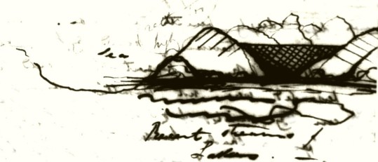
1 Sketches and diagram of Cerro Brujo (Finger Hill), Isla San Cristóbal (Chatham Island) with the words rather too high, recent streams of Lava, and Sea.
1835 Galapagos Isds
<Chatham>
Basalt, which on its margins thins out & covers the Sandstone. — The Basalt in central part of stream is very compact blackish grey: contains Crysts of red Olivine (?) <3235>. — The upper & inferior surfaces are cellular to some depth. — This Basalt must <<have>> existed as a pool of liquid matter within the Basin of the Crater. — The Kicker rock lies a few miles out at sea from this point. — it is <<of>> a most singular form. — a flat topped mass is surrounded by absolutely perpendicular cliffs & which from the depth of water, must be continued beneath the sea. — On one side is an equally abrupt spire. — The height is 400 ft. The whole consists of a Volcanic Sandstone similar to the last described [spot]. — I can only account for the fissure by supposing, that the external coatings have been removed & that the central mass which filled up the basin of a former Crater only now is left. — I have now mentioned four of these Craters, composed of Volcanic Sandstone.
1835 Galapagos Isds
<Chatham>
<How formed>They form the highest hills in this vicinity: & are of a more ancient date than much of the surrounding superficial Lavas. — As we know in terrestrial Volcanoes that may <<solely or>> at the close of an eruption or solely eject much finely comminuted ashes; so we may suppose the same to happen in a submarine one; the ashes here being in the state of <hot> mud which would soon be consolidated in regular strata around the orifice. —
I mentioned a stream of bare Lava as having flowed around the base of the Sandstone Crater: This has proceeded from a strange black distinct <<bare of all vegetation &>> studded over with small Craters so as to resemble those parts of Staffordshire & Shropshire where Iron Foundries are most common. — 1
In the space of a few miles I counted upwards of 60. — They arise on the sides of an undulating sloping piece of land. — In Mr. Scrope's work on Volcanoes2 there is a drawing <<of the Craters in Central France>> which gives a very good idea of this district. They are here <<however>> more numerous & smaller in size. —
1 Craterized district, Isla San Cristóbal (Chatham Island).
2 George Poulett Scrope. 1825. Considerations on Volcanoes. London: W. Philips.
How formed] added pencil.
1835 Galapagos Isds
<Chatham Isd >
The Lavas are of two ages: the <<surface of the>> one <<is>> entirely destitute of Vegetation, surface exceedingly rough, & the form like that of a sea petrified in its most tempestuous moments, & crossed by great fissures. — <(B)> The <<surface of the>> other is rather smoother, these fissures filled up with earth & partially clothed with a stunted vegetation. — By these characters streams of the two epochs can be readily distinguished; but taking into consideration the outline or forms <<alone>> the <<line division>> could scarcely be traced <(c)> — The Craters from which both these <sets of> streams have proceeded are nearly in the same state of preservation. — Their diameter commonly range from 30- to 150 yards. — they are elevated from <(a)> 50 to 100 ft above the surrounding country. — Generally the ring is perfect, that is after the Lava (which appears to have burst through the base) is perfect has flowed, a mass of scoriæ have been ejected & which have formed the Crater. — The Craters are commonly within 1/3 of a mile from each other. — some much close, even within 30 yards from rim to rim of distinct & perfect Crater. — The Crater consists either
[Notes to 755 (9)r]
(a ) The inside is nearly as deep, as the level of surrounding Lava. —
(B ) Near the outer parts of stream the fissures are generally parallel to the borders. — 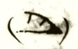 [small sketch] (section)
(c ) I have omitted to describe: the Lava is grey, irregularly vesicular with Olivine (3234). The irregularity in the form of the cells appears a common character in this part. — In parts there is an obscure prismatic structure & generally frequently the superficial parts are formed by loose cakes, which sound, when a person walks over them, like plates of Iron.1
1 Darwin apparently borrowed this imagery from James Colnett's book A Voyage to the South Atlantic and Round Cape horn… London: W. Bennett, 1798, a copy of which was on board the Beagle. See also Darwin's Galapagos notebook, p. 33b.
1835 Galapagos Isds
<Chatham Id >
of an irregular pile or more commonly a ring of black or red glassy scoriæ cemented together & mixed with [Repilla1 ] & fragments of Lava. — There were some Craters of another form consisting of mamilli — formed hill composed of a more compact, laminated Lava, with circular Crater & precipitous sides: it appear as if Lava had flowed on all sides at same moment from a point & subsequently that the orifice was blown formed by a circular central mass being blown up. — In several places & almost universally at the foot of these small Craters, there were nearly circular cavities from 30-60 ft deep & about the size of the smaller Craters. — sides precipitous: from the appearance of sides & bottom I have no doubt these are owing to the roofs of centres having subsided. — One small Crater had three of these surrounding it. — A case the reverse of this appears sometimes <to> have happened, where the Lava, [when] liquid appears to have been elevated into large bubble the summit of which having burst
1 Rapilli, or Lapilli.
1835 Galapagos Isds
<Chatham Isd >
has left irregular & deep cavities. At the Concepcion earthquake volumes of gas burst through the water in the Bay: such happening beneath fluid lava would cause the above appearance. — Generally ,where the Lava rises at the base of the Craters there were numerous small well ordered gutters from 2 to 4 ft deep.<nature & lava> <age of lava> — The roof was generally perfect & entire for considerable distances. — <Most of the small Craters have sent forth small streams of Lava:> <Looking at this district>I was much struck by the reflection how easily the sea would entirely remove these rings of scoriæ & from what I have above said how difficult it would then be to distinguish the different streams: the whole would appear as the result of one great eruption from one point: instead from very many points & at least at two epochs. — On the South side of this Island there is one Craterized district which appears as recent as this does. — Towards the west end of the Isd I landed in two places: in the both we had a black Basalt more or less vesicular & <3239> containing in some places is a good deal of Olivine.
nature & lava] added pencil.
age of lava] added pencil.
Most of the small Craters have sent forth small streams of Lava:] added pencil.
Looking at this district] added pencil.
1835 Galapagos Isds
<Chatham Isd >
In one station, the surface outline of the lava was very irregular although well clothed with low trees1 ; in the other, the country was smoother & I believe the Lava subaqueous, having flowed into shoal sea. —2 Anyhow in a cliff at this place3 , at a height of several ft above high water mark a breccia of huge fragments of vesicular & compact Basalt were united by a hard calcareous sandstone. In this were fragments of recent shells. I extracted the <3290> common fissurella, arca, & plates of a Chiton: all of which abound on the Beaches: The Calcareous matter had filled some of the cells of the more porous kinds <<of stone>>. — Here we have a proof of elevation to a small degree within recent times & which corroborates the fact of the dry pebble Beaches at Charles Isle. — Indeed, I believe, traces of a similar fact may be traced on the shores of this Isd . — At Barrington & Indefatigable Isds I hear of very little bare Lava. — but of abundant Craters glassy scoriæ arched gutters & that the both
1 Cerro Tijeretas (Frigatebird hill), Isla San Cristóbal (Chatham Island).
2 Southwest end of Bahia Stephens (Stephens Bay) near Punta Bassa, Isla San Cristóbal (Chatham Island).
3 Cerro Tijeretas (Frigatebird Hill), Isla San Cristóbal (Chatham Island).
1835 Galapagos Isds
are entirely Volcanic. — <Albermale> Isd is the largest in the Archipelago its length is upwards <<of 70>> miles. — 1 it is narrow in proportion is composed of five great principal mounds (& some smaller ones) which are joined by low land. — These mounds from form would appear to be surmounted by enormous Craters, from which bare & black streams of Lava can be traced down their sides. <<They are lofty, the one exceeding 4000 ft >> <the others between 3-4000 ft (a)> — The intermediate low [necks] of land & the flanks of the mountains are studded over with Craters. — I saw one point2 even more Craterized than the district of Chatham Isd . — Many of these appear to have been in recent action. Narborough Island <<(3720 ft)>> consists of one such mound it is separated only by a narrow straight from Albermale Isd . — Its sides are scored with naked Lavas, perhaps to a greater degree than anywhere excepting the East side of the central one of Albermales Isd. These two islands are the only ones in which there are accounts
1 Isla Isabela (Albemarle Island) is roughly 84 miles long.
2 Punta Cristóbal (Point Christopher), Isla Isabela (Albemarle Island).
[Notes to 759 (13)r]
(a) the one at SW extremity is 4700 ft to which may be added <<at least>> another 1000 ft for at that depth close to the shores no soundings could be were obtained: of the other mounds one is Volcano hill1 is 3720 & Whale Hill2 3730 & which heights agree in a [conforming] manner with that gre of Narborough Isd nearly 3720 ft.
1 Sierra Negra volcano, Isla Isabela (Albemarle Island).
2 Darwin Volcano (Volcán Darwin), Isla Isabela (Albemarle Island).
1835 Galapagos Isds
<Albermale Isd > of eruptions. We saw a Crater smoking in Albermale & in Narborough such has frequently been seen. Capt Pipon1 saw two in action at one time. — During the short period men have lived on Charles & James Isds an Earthquake has never been felt. — At the SE extremity there is a small outlying Isld (Brattle Isd ) in the form of a crescent2 <The internal diameter is 1 mile> some small Isd almost trace the circle of the Crater. — it appears entirely composed of Sandstone, the strata dip from the common centre at about 45°.—
Between In front of Narborough Isd there is a small cove (Banks cove)3 which is seated in the midst of Sandstone Craters. — I examined one a mile to the south with care. — 4 The Crater is elliptic: the longer axis runs N & S & is perhaps 3/4 of a mile long & 2/3 broard. — The sides are of nearly equal height; at the bottom, of the which is about 500 ft deep, there is deep lake of very salt water. — This can be only slightly elevated above the level of the sea. — In its middle there
1 Captain Philip Pipon of HMS Tagus sailed through Galápagos in 1814.
2 Isla Tortuga.
3 Caleta Tagus (Tagus Cove), Isla Isabela (Albemarle Island).
4 Cráter Beagle (Beagle Crater), Isla Isabela (Albemarle Island).
1835 Galapagos Isds
<Albermale Isd >
are three Islands in one of which a small Crater is very evident. — The Crater has an opening to the S or Seaward. — an immense stream of Lava from the mountain behind has crossed the mouth & has poured part of its contents inwards & part towards the Sea. — In the whole circumference of the escarpement of the Crater the rocks are Volcanic Sandstones. These generally are of a brown or yellow color light & brittle. <3249> Frequently there is a pisolitic structure <3250>: the balls from size of shot to small bullets, formed of thin concentric layers of the finer particles of the Sandstone. — 1 In the lower parts of the strata I noticed some compacter varieties. — In the Sandstones there are abundant broken crystals of glassy Feldspar & Olivine. — In many all parts very many large & small imperfectly rounded fragments of cellular &very compact Greystone, Basalt & much vesicular Trachyte. — These frag pieces are arranged in layers. I saw some strata almost entirely composed of such. — The whole
1 Accretionary lapilli.
1835 Galapagos Isds
of the grand circle of Sandstone is thinly stratified, all the folds dipping from <25 to 33° from the centre of Crater. — In no part is there a stream of Lava: but from the numerous fragments it is evident the volcanic eruptions must have burst through such beds of lava. — The external sides of the Crater slope up regularly at about same angle as the strata. — They are furrowed or radiated at very regular distances from the lip of the Crater to the base. This <<is caused by>> longitudinal doones as (from 8 to 20 & even 40 ft wide) which are seperated from each other by <<shallow>> gullies. The doones are not [merely] formed by the excavation of these intervening spaces, because the strata of each correspond with the external curvature. — The gullies, no doubt, have been deepened by alluvial action. — The appearance of the greater number, is that of the <top of a> plastered vaulted passage; the plaster being old, cracked & frequently separating in plates. —
1835 Galapagos Isds
<Albermale Isd >
Some of the archways only reach half way down the hill: the intervening gullies uniting,
the appearance does not differ from the ordinary furrows [impassed] by the drainage of
Basin water. — High up, these doons are sometimes really arched hollow channels: Both
their <<size>> structure & appearance is identical with those of Basalt described at
Chatham Island. — They are not however nearly so continuously hollow. — At the very lip
of the Crater they present the form of little hoods, the entrance being more or less clear. —
Also on the external side slope of mouth of Crater there are numerous, slightly [tortuous] gutters [small sketch] from 1-2 ft wide, formed of Sandstone & appears as if made by man to conduct a fluid. — There can be no doubt from this description but what this has been a Mud Volcano: from the [even] edge the boiling thick mass has poured over in narrow streams. From evaporation & cooling the upper surface has occassionally 
1835 Galapagos Isds
hardened whilst the central mass parts have flowed onwards. — It is worthy of remark that in this the highest part the pisolitic structure is well developed. — From the outline the archways & gutters being preserved entire, it is manifest the Volcanic mud flowed over the sides beneath the air & removed from the action of the sea. — Yet from the structure of some of the lower strata I suspect they are of subaqueous origin. — With this view perhaps the following fact may have some connection. — Within the Crater, in a few spots, there is a casing of Sandstone, which dips towards the centre of Crater. This is of the same nature but rather compacter <<& abounding with fragments>> as the [above] former kinds. the casing is thin & reaches to a height from 100 - 150 ft. — It may be described as a stratified <<& consolidated>> talus. — The strata were inclined at the high angle of 36°; it was remarkable that little or no thickening could be perceived in the extent of the lower part of [those] strata, which were visible <(a)> — At the foot of the Escarpment there were also large piles of loose detritus
[Notes to 764 (18)r]
(a) Section1 [small sketches]
1 Sketch of a section of Cráter Beagle (Beagle Crater) with an islet in the middle. Angle measurements and calculations are drawn below it.
1835 Galapagos Isds
<Albermale Isd > but of a very different structure. — If these strata were not deposited when the seas perhaps occupied this crater, they must be owing to the returning Volcanic mud which was not ejected at the last eruption. — From the present level of the lake in Crater, <<from the [clearness] of the Crater>> from the size & form of the mouth. — from the probability of a small horizontal upheaval it is very probable far from unlikely that the sea did once occupy the lower part. — At Banks Cove the Beagle was anchored within a Crater larger even than one described, but in a much more demolished state. Within the outer ring there is one (& I believe another) very perfect, & not very small Crater with a salt lake1 at its bottom elevated a few feet above the sea. — The whole are composed of Volcanic Sandstone: of the same nature, but where I examined, much compacter & harder & having more the appearance of a true subaqueous deposit. — The highest part is about 700 ft; the
1 Darwin Lake, Albemarle Island (Isla Isabela).
1835 Galapagos Isds
external sides, instead of affording a gentle slope, have been weathered by the sea into bold cliffs. — I could here perceive the angle of stratification gradually decrease towards the base of the section of part of the rim, & with this decrement the beds thickened. In this part also there was a much larger proportion of coarse fragments of Lava. Within the circle of the Crater there is nearly as much Sandstone, which has a converging, stratification or strata dipping towards the centre, as there is of that which dips externally: Hence the rim of the Crater is like the roof of a house; the stratification of this internal part is oftentimes curvilinear & very irregular, either from the effects of currents & inferior inequalities; it is in places very highly inclined so that in the cove there will be close to the shore from 50-100 ft depth of water. — I can feel a doubt that the whole of this Crater is the work of a submarine Volcano. — & that the internal converging Sandstone Illustrative Section of the Crater A & B the Rim of Crater.
 1
1
1 Sketch of Caleta Tagus (Tagus/Banks Cove) with the words A, 800 ft, B, Banks Cove, and Sea and an illustration of a ship.
1835 Galapagos Isds
<Albermale Isd > was deposited subsequently to the last period of activity: that horizontal upheavals have given it its present height; during <<which the action of the sea in this case is a perfect [illeg] >> which time the Sea has been wearing away much of the crater & which action is still continuing both from within & without. — I have particularly described these Craters because I do not recollect having read of an exactly parallel case. — nor indeed of a large Crater entirely composed of Volcanic Sandstone under any circumstances. All the Facts described are what one would suppose would <a priori> take place have resulted from a Volcanos situated as these appear to have been. — At Chatham Isd the Sandstone Craters were the had been the principal points of eruption in their respective districts: here they are quite subordinate to a great mound 3750 between 3 & 4 thousand ft high, at the foot of which they stand. — 1 From this great Volcano, torrents of Lava, have flowed, both from its summit & lateral small Craters. —
1 Volcán Darwin (Darwin Volcano), Isla Isabela (Albemarle Island).
which the action of the sea in this case is a perfect [illeg] ] added pencil.
1835 Galapagos Isds
<Albermale Isd >
One enormous stream many miles broad, almost entirely destitute of vegetation (I believe I must except 2 or 3 plants of a Cactus) interfolds behind & between the sandstone Craters. — To the north, for the length of several miles, it has entered the sea. — The whole of this Lava is finely characterized Trachyte. About four feet below the surface the rock is irregularly vesicular, Blackish grey & abounding with Cryst of fractured glassy feldspar. <3247>. — The very surface is composed of the same rock, only slightly more vesicular & with equally large Crystals <3248>. — The outline of the field of Lava as compared to the Basaltic one of Chatham Isd is much smoother. — there is not that appearance of huge frozen billows, or nearly so many fissures of contraction. On the contrary the surface itself is excessively rough. — I should compare the one to the ocean, the other to a lake violently agitated by a Storm. — The liquidity of this Lava must have been more perfect. — The fact is believed to be uncommon. — I judge of it from
1835 Galapagos Isds
<Albermale Is> these facts; the general surface is more horizontal; it has flowed through narrower channels & lastly the edges of the stream are infinitely thinner. — They consist of fragments of the more vesicular kinds, only from one to two or three feet high. — Very recent as this Lava appears to the eye, it is crossed in one part by a ribbon of blacker Lava which has flowed from a minute & perfect Crater high up on sides of mountain. — As the Sandstone Craters are seen to have burst through & ejected fragments of Trachyte & Basalt: it is probable they alternate. From the abundance of the former rock & the predominant dimensions of the described stream of Lava, I should suppose this Volcano <(a)> is essentially a Trachytic one. —
<James Isd> The only part of this Island which I examined is the west side. — The country here gradually slopes upwards to an elevation of about 3000 ft. — The whole is Trachytic Lava: the streams do not appear modern
[Notes to 769 (23)r]
(a) The extreme great north mound on Albermale Isd is — <<between 3 & 4000 ft>> high.1 The external rim of the Crater fixed by the triangulation of the survey has a diameter of 3.8 miles. — The other Craters in this island to the South have even greater dimensions.
1 Volcán Wolf (Wolf Volcano), Isla Isabela (Albemarle Island).
1835 Galapagos Isds
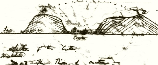
<James Isd > as they are well clothed with Vegetation. The streams as seen in the <<cliffs on>> Beach are generally thin & are separated by Scoriæ. In several parts there are old broken down Craters & in the central highest part of Isd — about 8 miles inland <<(& between 2-3000 ft high Estimation)>> there is a large & perfect Crater, circular, sides very precipitous <<& bottom walk wooded>>. In the vicinity nothing but Trachytic Lava is found: the channels by which the Lava has flowed over the rim are yet visible. — The walls of the Crater are chiefly composed of bright red & very glassy red scoriæ united together1 — The Trachytic Lavas in the lower parts of this Isd are very cellular & the imbedded Crystals of glassy Feldspar very large & abundant <3265> <3266 with olivine?!>: — In the higher central part the rock generally is more compact, the base blackish grey <3267> with scarcely any Crystals & or they are abundant & small <3268>, the basis itself being Crystalline.— A small bay, close to Albanie Isd2 is formed on its NE side by a promontory, which would appear to be slip out of centre  [small sketch] of an old
1 Cerro Pelado (0°12.365'S 90°47.040'W). Darwin also describes this crater in his Galapagos notebook, p. 46b. However his estimation of the size of the crater in the notebook ( "1/3 of mile diameter") does not correspond to Cerro Pelado (which is roughly 1/8th of a mile across) but to a near-by bowl-shaped depression at the summit of the island (0°12.724'S 90°46.872'W). The depression is large but gently sloped, uneven and without the red scoriae. The geological specimen (#3268) that Darwin collected in this area closely matches an outcrop of trachytic lava located between Cerro Pelado and the depression. See Herbert, S., Gibson, S., Norman, D., Geist, D., Estes, G., Grant, T. and Miles, A. 2009. Into the Field Again: Re-examining Charles Darwin's 1825 Geological Work on Isa Santiago (James Island) in the Galápagos Archipelago. Earth Sciences History 28(1): 1-31.
2 Albany Island.
1835 Galapagos Isd
<James Isd > Crater , the both sides being worn into precipitous cliffs by the action of the sea. — There is however some confusion in its structure. — The exterior diverging layers are almost solely composed of coarser & finer fragments of red glassy scoriæ, rapilli, fragments of Trachyte & their detritus. — In one part of the pile there were numerous <<& large>> fragments of a harsh red Claystone base, containing small bright red earthy specks <3275 very compact>, more or less vesicular & a varying quantity of glassy Feldspar Crystals. — I did not succeed in finding any stream of this Lava, although somewhere such must be in <<large great >> quantity. The fragments in the various layers are but little rounded & scarcely at all agglutinated together. In the higher parts, there were some fine & so well arranged paper-like layers of consolidated pumiceous dust; that I at first imagined they must have been of subaqueous deposition. — Immediately beneath these there was a thin [stratum] of very small & weathered fragments of Rapilli; with these were thousands of a small Bulimi: the shell in an excessive state of decomposition.—
1835 Galapagos Isds
<James Isd > When these shells were alive; this Layer must have formed the base surface of the Volcano. This proves the terrestial origin of at least all the upper parts of the Promontory. — In the middle <<& lowest part>> between the diverging piles there is a nearly horizontal bed of Lava, which thins out at its edges & appears to have filled up formerly the basin of the Crater <It is about 200 ft thick>. — The stone is a compact blackish or greenish <3267:68 like> with but few Cryst of glassy Feldspar: Its lower surface to the thickness of about 2 ft, where it lies on the Volcanic detritus is an igneo-cemented mass of fragments: these consist of the same substance slightly & finely cellular & containing larger & more numerous Cryst of glassy Feldspar than the compacter kinds. — The piles of scoriæ are traversed in several places by great broard dykes which are many yards thick, which run <<vertically>> for considerable distances. — They consist of a grey compact Trachyte <3279>, with only few Crystals of Feld. the sides & certain spots are cellular. — Parts of these dykes stand out isolated in the
1835 Galapagos Isds
<James Isd > sea forming lofty & singular pinnacles. The sea, when removing the loose fragments on either hand, has been unable to remove these & they now point out some of the limits of the former Crater. — In the piles of diverging strata there are some small Lava streams; these probably have flowed from a point of eruption in one of the grand dykes. — At a spot where a small ravine enters on the Beach; we have two sections at rt ∠s to each other. — The corner, or the line of junction the two, falls in the very centre of one of these small subordinate Volcanos.1 I have drawn the section which faces the Sea Beach. — [small sketch2 ] on the coast there are two or three little detached paps of a brown, small cellular Trachyte <3278>. — one of these rises to the height of 15 ft; is very irregular in form [small sketch] & [marks] the basal part of the corner. — In actual junction with it, three small streams of Lava [bends] upwards as if over the rim of the Crater & then slope
![]()
1 "Darwin's layer cake". See Estes G., Grant K. T., and Grant, P. 2000. Darwin in Galápagos: His footsteps through the Archipelago. Notes and Records of the Royal Society of London 54(3): 343-368.
2 The sketch of "Darwin's layer cake" is labeled with the words Ravine and Sea Beach. A rendition of the mirror image of this sketch was published in Volcanic islands.
1835 Galapagos Isds
<James Isd > continuously downwards. (— As I have drawn the point it is too regular.— ) Above these are 6 more thin streams, which are not now joined to the column of Trachyte. — These streams are very diminutive, upwards, (part seen in the Ravine section) They have an extension to about from 10 -15 yards; downwards from 60-80. — It must be remembered this eruption took place on the slope of the greater Volcano. — The thickness of the streams corresponds to their small lengths. — They all consist of a highly cellular greyish base abounding with large & numerous Cryst of glassy Feldspar. — The outer surfaces for about 2-4 inches deep is converted into bright red glassy scoria <3269>. Small <<Loose>> fragments of such scoriæ seperate the streams. — I measured one, of which the dark Trachytic part was only 8 inches thick, to which may be added 6 inches for the superficial external coatings of red cindery matter, giving 14 for total thickness, & this is the [dimension] for the whole length. — Another, for a space was altogether only 8 inches. — The rest from one to three ft:
[small sketch]
1835 Galapagos Isds
<James Is> The loose intervening scoriæ are of another greater thickness. — It is remarkable <<thus>> finding Trachytic lava, a kind supposed by many to possess very little fluidity, forming streams only 8 & 14 inches thick. — I should suppose <all> this Lava has been ejected at one epoch of activity, small intervals of time separating the streams. — The Trachyte here is interesting from containing very many small generally angular fragments of altered rock, which clearly have been Granites & Ignites. — Hand specimens do not impress the idea of their extraneous origin, with the force with which inspection of the bed itself does. — <3270:71:72:73>. The <<glassy>> substance into which the mica has been changed is remarkable. — One piece seems to have been part of a Quartz vein (3274) <3274>. — The Feldspar is in nearly the same glassy fractured state as is the Trachyte. (Is the form & size similar?) It will be observed that the fragments have not become vesicular. — In a like manner the Crystals of the most vesicular varieties <<of Lava>> are not thus affected. — One is led to suspect that all such Crystals proceed from the
Mem [Br] Lyell somebodys Paper on Leucite
1835 Galapagos Isds
<James Isd > Granite & that they are not produced in the liquid Lava. — Inspection of a specimen of a cindery, regularly & highly vesicular Trachyte, brought from Abingdon Isd by Mr Chaffers <3288>, where the Crystals are very large & perfect, will tell more on this side of the argument than any description. — Yet I am unwilling to take up this opinion: If the Trachyte is melted Granite the quartz & mica has formed the more feasible past! <which forms composes the matrix for is glassy Feldspar:> — In the fused mass, when at an intense heat, does not the quartz & a small portion of the other ingredients form the Crystals of glassy Feldspar. — May not these Crystallize at a temperature when the other rest of the matter is fluid? This will explain the imbedded <& extraneous> appearance of the Crystals. — I do not however understand <<in any point of view>> the observation, which I believe to be exact, in that the Crystals abound more in the more Vesicular varieties. — To return to the Promontory, on the inland side the layers of scoriæ are covered or encased by a thinly stratified dark greenish-brown, light brittle <3276> <3277> Volcanic Sandstone. — The bed is from 10 to 20 ft thick: it contains a few large nearly angular fragments of Lava: its
1835 Galapagos Isds
<James Isd > structure is in many places highly pisolitic. — The Sandstone overlies the red detritus & scoriæ, without any passage in the nature of the two. — In the basin of Crater rests on the solid Trachyte: from this folds over the rim of Crater & covers the external slope with a <<nearly>> uniform slope sheet. I observed however here traces of those longitudinal [convex] furrows, which may be compared to the [rays] on the shell of the Pecten. — To the south & at head of the cove, there are other old Craters, the upper strata of all of which resemble this Sandstone. <thin out> The lines of curvature from these different hills join, as if the Sandstone was one envelope. — I did not actually trace the unbroken strata. — At first with the <<consideration of this>> outline; of the stratified nature & compactness as compared to underlying scoriæ, <&> the sudden change in composition, I was perplexed concerning its origin. As it [overlies] the cinders <<with the Bulimi>> it must be terrestrial (which I originally doubted), hence either streams of mud have flowed out like Lava
thin out] added pencil.
1835 Galapagos Isds
<James Isd > from the Craters, or ashes having fallen, has been consolidated by subsequent torrents of rain. — The latter supposition will not explain the longitudinal arches, hence we are reduced to mud eruptions. <(a)> I may observe that cases might arise which would cause much difficulty. — for instance parts of such mud entering the sea. &c, &c.— I have already alluded to a Volcanic hill on the opposite or South side of the Bay Harbor: it is the highest <<(850 ft)>> in the neighbourhead; is surmounted by remains of a Large Crater.1 — The whole is composed of Volcanic Sandstone, full of fragments of Lava, which abound to such a degree, that some layers are composed of them. — The outside is worn into high & steep cliffs; which are continued deeply beneath the sea. — I do not doubt from the appearance & hardness of these strata that they are of subaqueous origin. — I observed one fact in the sandstone which as it bears an analogy to a somewhat similar fact, described in Chiloe <P. Huapacho2 > — I will mention. — In one part of the steep cliff, where the Sandstone was yellower, finer grained & softer there were dyke shaped masses with vertical & parallel sides,
1 Cerro Cowan, Isla Santiago (James Island).
2 Punta Guapacho, Chiloe.
[Notes to 778 (32)r]
(a) It is true such might be produced to a certain extent by the Mud carried by the Rain flowing down the hill sides. — It may be doubted how if the stratified appearance structure would be produced. — Yes it perfectly is as seen in the Isd of Ascension: The whole question must be considered with case, but the hollow channels afford a heavy argument in favor of mud eruptions. —
Yes it...eruptions. —] added pencil.
1835 Galapagos Isds
<James Isd > & others irregularly wedge shaped of a darker colour & harder Sands kind which in consequence projected in relief. — The fact change is rendered the more remarkable by lines of gravel of different degrees of coarsness, crossing both kinds. — When I state this I must add that sometimes there is a trifling irregularity at the points of junction: The line of junction has very frequently a serrated margin.
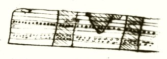
The appearance is as if some fluid had percolated through fissures & altered the rock to a certain distance on each side. <(a)> — On close inspection I did not think such an explanation admissible; But rather it must be owing to some <<<constant or frequent>>> current flowing longitudinally from the lip toward base of slope, thus slightly altering nature of depositions. — About five miles to the south of the above described localities, (at Puerto Grande), there is a field of Lava1 about 4 miles long & 1-2 broard.
1 James Bay lava flow, Isla Santiago (James Island).
[Notes to 779 (33)r]
(a) [This] is chiefly grounded from some of the irregular masses expanding in these upper parts into the regular overlapping strata. The sections of Craters with their strata dipping away from common centre on all sides shows very regular arches one within the other: if the section reaches deeply towards the rim the curvature is great arch is a very large one.
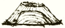 [Small sketch1 ].
1 Cerro Cowan, Isla Santiago (James Island).
1835 Galapagos Isds
<James Isd> which is bare & utterly destitute of vegetation & the surface glossy — the sides of the little Fissures which have acted as Fumaroles are yet white. — Recent as this stream appears it is crossed by another one of a slightly darker color but same constitution. — Near Close to a wall within the marginal fragments of this stream some low but old trees1 are growing. I conceive these must have been killed if they had been there when the Lava flowed. Hence we see how long the surface has resisted decomposition; to this day it is fresh & glossy. — <3280> The lava is a Greystone, which abounds in a very remarkable degree with Olivine, is generally very vesicular & sometimes of rather a darker color. <3281> — The Basis is nearly the same as in the Trachytes; the Olivine here <<appears to>> replaces glassy Feldspar. — The surface is smoother than in the Basalt of Chatham Isd yet here there are great waves & fissures. The superficies itself has assumed singular ringed & twisted forms which resemble cables, folds in thick drapery & rugged bark.
<[illeg] [mention] Douglas [on] [ferns]> <Vol IV p 337 19 months after wards rose strong through the fissure> <"and have sent forth luxuriant fronds as though nothing had happened to them, much less that they had been deluged with fire2 !!—>
1 Palo santo trees (Bursera graveolens).
2 Quoted from: Anon. 1834. Extract from a Private Letter addressed to Captain Sabine, R.A. F.R.S., by Mr. David Douglas, F.L.S. Dated Woahoo (Sandwich Islands) 3d of May, 1834. Journal of the Royal Geographical Society of London Vol. IV, p. 337.
[illeg] [mention]...with fire!!—] added pencil.
1835 Galapagos Isds
<James Isd>
These streams of Lava have burst from several small Craters, placed at the base of the high central Trachytic hills. — Near to the sea, a small Crater of glassy red Scoriæ & Greystone has been overwhelmed & almost concealed beneath the flood of stone.1 About 1 &1/2 mile from the Beach, there is a Salina which is worked for salt.2 — It occurs in a Crater, round the base of which the Sea above the sea above field of Lava has flowed. — The Crater in diameter is about 1/3 mile wide; is circular, sides very steep & beautifully regular. The Rim is rather higher on one side, where it is about 400 ft above the basin, than on the other: but in is no where broken down. — The Crater is much deeper than the surrounding country, indeed on the SE side, streams of ancient Olivine Lava have nearly brought the country up to a level with the brink. <a> The whole upper part of the walls is composed of a compact glassy yellowish-brown Volcanic Sandstone <3282>; some of it has a semi-Resinous fracture & contains small glassy patches <3283> & resembles
1 Kipukas in James Bay, Isla Santiago (James Island).
2 Mina de Sal (Salt mine crater), Isla Santiago (James Island).
[Notes to 781 (35)r]
(a) Has a sub-concretionary structure.
1835 Galapagos Isds
<James Isd > that of Chatham Isd. Lower down there is some brown ordinary Volcanic Sandstone with a pisolitic structure. The whole contains fragments of Lava & I do not doubt is of subaqueous origin. Such Sandstones compose 2/3 of <<depth of>> sides of Crater, the lowest third is much steeper & nearly precipitous, — so that the Crater at its upper margin is marked in its whole circumference by a kind of ring. < [small pencil sketch]>This lower third is composed of an olivine Greystone Lava. — It would appear, as if the whole bottom of the Crater, in which was
 be a bed of solid Lava had been blown up & that subsequently a great emission of ashes beneath the water had formed the upper 2/3 of unbroken rim. — The Basin of the Crater is now occupied by a lake of brine round which there is a green margin of Saliferous plants. The aspect of this & steep wooded sides have rather a picturesque appearance. — The lake is from 6-12 inches deep, it never drys, the water rests on a layer of pure Salt. —
1835 Galapagos Isds
<James Isd >
The Salt is quarried from the central parts of the lake, the margins being soft & muddy. (a
circumstance which happens in most Salinas). —
<Daubuisson Vol I p. 189 like mud volcanos of Sicily called salses for quantity of salt1 .>
There are three or four layers, each about 3 inches thick; they are separated from each other & rest on impure earthy layers <<of Salt>>.— Some of the Salt is Crystallized in beautiful cubes nearly 2 inches long in the square. — Is the salt a Volcanic exhalation? Or when the Crater was close to & on the level of the Sea, <(a)> did the Salt water percolate into it & deposit the Salt. — Perhaps an analysis of its Brine may throw some light on this. <1311 Tin label>. — At the distance of 2-3 miles there is another hill of similar appearance, in the Crater of which there is said to be another Salina. — Still closer there is a more lofty hill <(1200 ft)> than either, entirely composed of Volcanic Sandstone.2 Mr Sulivan informs me the Crater is dry, but beautifully perfect <circular>, its depth is about 600 ft, the bottom appeared on a level with the surrounding country.— <<the S side is a good deal lower than the north>> The Sandstone, belonging
1 In Volcanic islands, p. 112, Darwin refers to D'Aubuisson's Traité de Géognosie tome 1, p. 189.
2 Pan de Azucar (Sugar Loaf), Isla Santiago (James Island).
[Notes to 783 (37)r]
(a) Mr Sulivan informs me that there is a small Isd on the S East end of James Isd which consists of <<a mere circular ridge>> Volcanic Sandstone its diameter is 1/3 of mile. — is very low towards the South but not fairly broken through; it contains a shallow lake of water which appears to rest on Salt. This water appears to be on same level with the Sea.1 —
He has seen another Crater in which the <<Sea->> water entered at only at times of high water. —
1 One of the Rocas Bainbridge (Bainbridge Rocks).
1835 Galapagos Isds
<James Isd > to this mountain, where it is exposed in the low cliffs on the Sea- Beach, appears to me to be of Volcanic subaqueous origin. — Yet higher up on the flanks of the mountain, its nature precisely resembles that of which I have described as being a terrestrial mud eruption. — The lower slopes of this mountain are really extraordinary, from the great extent & perfect smoothness of the folding layers of this substance. It precisely resembles an immense plastered floor. — The smoothness is only interrupted by small & very narrow branching cracks <(a)> Mr Chaffers communicated to me the foll information respecting the following Isld s. Bindloes Isd . — The Volcanic rocks appear very recent & are only in a few places clothed with Vegetation: The commonest kind is a jet Black glassy scoriæ: <3286> which has assumed the various forms of melted lead poured into water. — it must have been reduced into a state of very complete fusion. — I saw also specimens of finely characterized Trachyte. — There is a steep crater also of Volcanic Sandstone; out of
[Notes to 784 (38)r]
(a)  [small sketch].
1835 Galapagos Isds
<Bindloes Isd >
Which Mr Chaffers procured 3 species of shells, &saw many fragments of an Oyster.
<(3292)> I am aware that Volcanic <<mud>> eruptions might well eject shells: but I
think there is at least an equal probability that the Sandstone is a submarine deposition &
has been subsequently raised to its present elevation of about 300 ft.
<Towers Isd > Towers Isd <<Hood:Charles>> is remarkable by its lowness &
flatness & apparently not containing a single Crater: is composed of rather thin strata of a
brownish very cellular (minutely Trachytic?) lava <3287>
<Abingdon Isd > The commonest rock is a reddish brown very cellular; cells small &
regular, imbedding vast numbers of very large Cryst of glassy Feldspar & which has been
mentioned <3288>: There is another kind, heavier, more compact, almost composed of
less fractured Cryst of glassy feldspar, separated by angular cavities. — <3289> In this Isd I saw also a large Sandstone Crater.
Culpepper & Wenams Isd . are situated about 70 miles to the north of the archipelago. —
They both show remains of being an ancient Crater & consist of hard rocks. —
Hood:Charles] added pencil.
1835 Galapagos Isds
Considering the Islands in the whole Archipelago; it may be remarked, that the Southern ones <Chatham> appear to be entirely composed of Basalt & Greystone, whilst the northern division is more essentially Trachytic. — In both of these formations the remarkable Sandstone Craters are common. <<It is said>> mud eruptions have generally taken place exclusively in Trachyte <<formations>>; the Salina in James Isd offers a well-marked exception. — <Sandwich>. These sandstone craters offer the most remarkable phenomenon in the geology of the group. — It must not be supposed that I have seen a quarter of <Obsidian> their number, or that I have described all I have seen. Their [presence] is the more remarkable as no where did I see ashes on the surface of the land. <generally near sea> — I heard however of one instance where such fell on board a vessel near James Isd . — Moreover the surface of in <a> the more recent streams of lava appears to resist decomposition for a singular length of time. — It certainly is strange that such rocks should give rise to mud
Chatham] added pencil.
formations] added pencil.
Sandwich] added pencil.
Obsidian] added pencil.
generally near sea] added pencil.
[Notes to 786 (40)r]
(a) I saw no where a well-formed column in the various sections of the Lavas.
[The following pages are unfolded sheets measuring 20.5 x 25.5 cm]
1835 Galapagos Isds
eruptions. — It may perhaps be observed that <<perhaps>> those Sandstones which I believe have been of subaqueous origin possess a concretionary or nodular structure & those which have flowed as mud, a Pisolitic one. — The idea of the submarine origin of much of this Sandstone necessarily presupposes an horizontal elevation to account for their present position. If the shells found by Mr Chaffers at considerable elevations are not considered as proofs; yet we have shown in the northern division, that such has taken place at least to a small degree. — In my own mind I can feel no hesitation about the extension of the fact. —
The vast & almost infinite numbers of craters, with which all the Islands are studded gives them a singular & highly characteristic aspect. — There is one very interesting observation made by Mr Stokes1 , Sulivan2 & Chaffers3 <<in their respecting surveys>> — namely that all the Craters are open or have the low part of their circumference on the South side. <<have their Southern side either much entirely broken down & removed or much lower than the remaining other parts of the circumference.>> This is more especially manifest in the low small Islands which consist solely of the ridge
1 John Lort Stokes.
2 Bartholomew James Sulivan.
3 Edward Main Chaffers.
The vast ...the ridge] paragraph crossed out with a large X.
have their...circumference.] added pencil.
1835 Galapagos Isds
There is one very interesting observation made in their respective surveys by Mrss Stokes, Sulivan & Chaffers, namely that all the Craters have their Southern side either entirely broken down & removed, or much lower than the other parts of the circumference. In the beginning of this Chapter, I have mentioned the extraordinary numbers of the Craters scattered throughout the group: these may be divided into three Classes. Firstly, the <<immense>> cauldron-like orifices of the Volcanos, which form the higher & central parts of the main Islands; secondly the <<numerous>> minute ones which are at most have only poured forth one or two streams of stony Lavas; & lastly the Craters composed of Sandstone, these in dimensions are generally intermediate in size between the two first classes. — It is, amongst this <<Latter>> kind of Craters, & especially when such happen to form outlying Islets that the fact, of the Southern side being most broken down, has invariably been observed. The following eleven islands are all more or less perfectly Crescent shaped; the southern half, having been nearly almost entirely removed. Brattle Isd which
[The following pages consist of sheets folded in half, to make four pages. Size of each page is 20.5 x 25.5 cm.]
Galapagos Isds
<[illeg]> is the largest & most perfect, the internal diameter, of the Crater being one mile; the three Crossmans1 & Enchanted Isd 2 ; these five are situated to the Southward & Eastward of Albermale Isd: Gardner, Champion & Enderby near Charles Isd : two small islets near Indefatigable Is3 & one near James Isd. 4 Mr Sulivan [illeg] also informs me that near the SE extremity of this latter Island there is the small Islet which has been described as containing a Salt lake has the Southern a part of the Southern side of the circular ridge not higher than 20 ft, whilst the remainder is perhaps 5 300 ft above the level of the Sea. Of the Sandstone craters situated on dry land, I can enumerate sixteen, which have the sides facing the South either quite open or much lower than the other parts of the Circumference. Charles Isd <<has>> two: Chatham two: Albermale three: James six: Bindloes two: Abingdon, one. — One of those in James & another in Chatham Isd have their northern sides low, but not so low as the Southern. — Thus altogether 28 instances have been adduced: in all these cases the low part is directed from SE to SW; I know of no certain exception
1 Los Hermanos.
2 Cowley.
3 Islas Daphne.
4 One of the Rocas Bainbridge (Bainbridge Rocks.)
Galapagos Isds
to this law, although probably some must occur. I must however observe that with respect to the 16 craters (not forming Islands), <<that>> as my accounts of some, were received from officers who necessarily paid more attention to the figure than the constitution of the land, I feel doubtful whether two or even three are not Lava, instead of Sandstone Craters. It must be remembered that the law does not appear, for examples are deficient, to extend to those Craters composed of solid Lava: I know certainly of three such, being open to the Southward, but likewise of an equal number, which are directed to different <<2>> or opposite <<1>> points. — The explanation of the apparently most strange circumference of all the Craters over a large district being broken down in one direction, does not appear difficult. Throughout the islands of the Archipelago, both the sea, from the trade wind & the long swell of the Great Ocean constantly unite their unwearied forces against Southern shores. Hence, that side, especially in the more exposed Islands, is bold
NB The trade wind has affected the forms of the craters at Ascension & must in a like manner have produced an original weekness on one side in these cases. —
page in pencil.
Galapagos Isds
& precipitous, whilst the northern shores approach the sea with a gradual slope. Taking into consideration the soft nature of the Sandstones, their probable subaqueous origin & progressive emersion; it would be strange, if those Craters did not bear witness by their ruined state, in a manner even more evident than the hard Lava rocks, on which side the ocean has exerted its powerful, unceasing action. — All the Craters in a large Archipelago thus having one certain side high & the opposite low or broken down, immediately calls to mind the nearly parallel fact in the Lagoon Islands in another part of the Pacific. I am so much the more bound to point out this coincidence, as I am no believer in the theory of Lagoon Isd [fasting] <being> based on the circular ridges of submarine Craters. — It is well known, that the opening & low parts of those Islands, is with respect to the direction of the wind, on the Leeward side; the surf however from the SW swell is nearly as great on that, as on the wind ward side: in this respect, therefore the case <(a)> of the Sandstone craters & that of the Lagoon Isd is not entirely similar
[Notes to 791 (42)r]
(a) There is another circumstance connected with this subject, which is of some interest. Five of the great Volcanic mounds of Albermale & Narborough Islds , which are surmounted by Craters having a diameter of between two & three miles, appear to the eye to be of an equal elevation. Three have been measured by angular observations: two in Albermale Isd1 are respectively 3720 & 3730 ft & that of Narborough Isd 3720 ft high. Inspecting the chart, one is tempted to exclaim; on such foundations, ready placed at an equal height, the Lithophytes might soon raise to the surface, their circular ridges of Coral rock. —
1 Sierra Negra volcano and Volcán Darwin (Darwin Volcano).
1835 Galapagos Isds
When now speaking on this subject Having alluded to the subject of the coral formations I nearly must notice the entire absence of all Coral such reefs in amongst these Islands. — Islands which are situated in the Pacifick & under the Equator. — Is it owing to a deficiency of <(a)> Calcareous matter? At James Isd from the fragments contained in the Lava, it would appear that the fundamental rock is Granitic. Does such extend under whole group? If so, does this account for the absence of a matter so common in Volcanic countries? Capt Fitz Roy has suggested that the cold water, which occassionally <State Facts> is brought up from the under currents & reduces the temperature of the Sea, on these shores, to a degree, perhaps unparalleled in such a Latitude, may account for this absence of a tribe of Animals, which seem to require a highly raised only to flourish where the heat is intense. — How far this idea ingenious idea may be of general application, will require extended observation.
[Notes to 792 (43)r]
(a) The only exception, which I know of, is a very little Calcareous Tufa at Chatham Isd . Are not coral formations equally absent in the Sandwich Isds ? — No
Galapagos Isd
From the Weather Journal kept on the board the Beagle, I find the mean temperature of the water of the Archipelago the Sea to be 68° (67°.9). The number of observations in number were 99, taken every day with some exceptions every day at 8 AM, noon & 8 PM; from the 16th of September when we first made to Chatham Isd to the 20th of October, when we finally left the <<the number>> Archipelago. — During this time the Beagle was either at anchor in different harbors or moving from Island to Island. The lowest temperature observed was 58° 1/2 at the SW extremity of Albermale Isd: several times on the West side of the same Island the temperature was 62° & 63°. — Now I find that from the 19th of November October to the 28th of [November], during which time we crossed the Low Archipelago, anchored off two places at Tahiti <<in the [whole] [of] which [illeg] [illeg]>> & sailed from it for 48 hours; the <<mean>> temperature of sea ascertained by 44 observats: was 77.5; & the lowest any day being 76.5. The difference therefore in the mean temp of Galapagos & <<of the ocean around>> Tahiti was 9.5: but the difference of extreme lowest 18° & frequently 14°. — We know that the whole ocean, near Tahiti abounds with Coral animals; & therefore we may presume the temperature of the Sea is there perfectly favorable to their growth; it may
[continued from 793 (44)r]
<<It seems probable>> easily be believed that an the same inhabitant of the Tropics & especially a marine marine families one would never survive never flourish <<not [true]>> so great a change as 18° under a temperature liable to vary to the amount of 18 degrees under two temperatures differing by so much as 18 degrees. — What is general mean Temp of ocean beneath Tropics? Vide. Humb. Voyage to Equanox: Regions: 3d Vol. Chap 39. — <<Vide latter part of VII Vol of Pers Narrative1 >>
NB. Humb. Frag. Asiatiqu. Vol II. P. 560.2 Some curious facts of coldness of deep waters of Pacifick in Lat 20°: currents from which are probably thrown to the surface by the outer parts of the steep volcanic Isd of the Galapagos.
Mean temp of Equatorial ocean <<oscillates between>> 26°.8 and 28°
80 - 83 Fah: Vol VII , 369 Pers Narr:
[The following pages are single unfolded sheets measuring 20.5 x 25.5 cm]
2 Humboldt 1831. Darwin also remarked on this in the Red notebook.
It seems probable] added pencil.
Vide latter part of VII Vol of Pers Narrative] added pencil.
Mean temp...Pers Narr:] added pencil.
Galapagos Isd
To conclude with this Archipelago: it has been remarked that the great continent of Africa is skirted at wide intervals by certain Volcanic Islands: much in the same manner we meet at a distance from the shores of S. America & beginning with the Atlantic, the Leeward Isles — Fernando Noronha, Trinidad, Martin Vas., S. Shetland, the two islands of Juan Fernandez, S. Felix, the Galapagos & Cocos. Nor is the idea of some physical connection altogether futile: everyone has heard of the coincidence of the earthquakes of Venezuela & the eruptions of the West Indian Volcanos: in a like manner twice during the violent agitations of the <ground> in Chili, Juan Fernandez (distant 330 geograph. miles) has suffered from Volcanic phenomena. <no Pumice> — Indeed at the Galapagos I imagined I saw in the abundance of the Trachytes & mud eruptions an alliance to the Volcanic formations of S. America: The nearest part however of the continent is 540°
could the Basalt forming Paste to Trachyte be softened & so basalt formed with less heat than Trachyte. —
[J. Ins]1 p. 247 —
(Does not explain olivine)
Berzelius2 thinks Olivine a preexisting [mineral] on account of [uniformity]3
{Sandstone craters with basalt in Chatham Isd 4 as well as James5 }
(No one crater <<In Chatham>> preeminent. Mem. azores
1 On Notebook A p. 31, Darwin wrote: 'There are some ideas about order of injected rock being determined by fusibility in L Institut p 247. 1837. — The most infusible first injected. — Basalt: last because it could reach the surface. before being cooled. —'
2 Jöns Jakob Berzelius.
3 On Notebook A p. 32, Darwin wrote: 'Berzelius. L'Institut. (1837 P. 297) thinks Olivine a preexisting mineral. — Mem. Galapagos:. Basalt deepest??'
4 Cerro Brujo (Finger Hill), Isla San Cristóbal (Chatham Island).
5 Mina de Sal (Salt mine crater), Isla Santiago (James Island).
could the Basalt...Trachyte. —] added pencil.
Galapagos Isd
distant. In the direction of the principal Volcanic vents & of the islands themselves a NW & SE line may be discovered. The principal line, pointed out by the linear shape & by four of the great mounds of Albermale Isd, includes also the distant small islands of Wenman & Culpepper & Charles Isld. — the direction however of this line is more truly NW by N than NW. Narborough Is & the SW mound on Albermale Is. make a second short parallel line. A third, directed NW & SE, is formed by the Islds of James, Indefatigable, Barrington, the shoal, & Hoods. A fourth, but not so regular a line, by Abingdon, Bindloes & Chatham Islands. — This direction will be seen to be parallel to the whole coast of N. America, & to be nearly in the same line, with that part of the shores of S. America, between C. Blanco & Arica. I have carefully pointed out, this construction of the archipelago, by four lines, directed from SE to NW, because it will hereafter be seen, over how vast a space, the form of the land has been influenced by lines, intersecting the Meridians at a uniform angle. —
Daubuisson Sandstone crater p 189 Vol I —
(Mackenzie Iceland Volcanic rocks1 )
(Abich on Leucite preexisting in Lava. Bull: Geolog. Soc. VII, 1832-1835)
Mackenzie has talked Lava flowing up Hill what do I mean p.390 2
See Red note B3 p. 2 ![]() [small sketch] XX Also p.34 —
[small sketch] XX Also p.34 —
craters broken down on one side Ascension
It will be safe to state that the feldspathic materials might be sorted & these basal forms base mountain Von Buch states structure [in] trachyte overlies base. At Auvernge very little Pumice though Trachyte same at Galapagos (p. 24 Daubeny)5 This [respect] contrast to Cordillera. Pumice <Etna Auvergne>
NB at St. Helena  [small sketch6 ] this volcanic structure will be discussed.
(Daubeny7 p 386. Good account of ejected fragments)
(Von Buch very strong about Trachyte being first ejected)
(Strong currents off Galapagos <<deposit probable>> with singular embedded remains
R.n. 558 XX
(Pisolitic balls p. 72 R N)9 (Olivine preexisting mineral A: p. 32)10
(Order of Ejected lavas A. p. 31)11
1 George Steuart Mackenzie. Travels in the Island of Iceland. (1810), pp. 389-390. Mackenzie remarks on bubbles or blisters of lava, and lava flowing up hill.
2 This same note is found in the Red notebook, p. 159.
3 Red notebook.
4 Pages 1e-4e of the Red notebook have not been located.
5 This same note is found in Red notebook, p. 38e.
6 This same sketch is found in Red notebook, p. 110.
7 Daubeny, Charles. 1826. A description of active and extinct volcanoes. London: W. Phillips.
8 On Red notebook p. 55 Darwin wrote: 'Strong currents off the Galapagos. — strata must be accumulating which like the secondary strata of England, <<besides ordinary marine remains>> may contain <shells few corals Tortoise> <<remains of Amphibia, exclusively.>> & Turtle bones. & the bones of <two graniniverous> a herbivorous lizard. — from the action of torrents. <<marine>> Tortoise & other species of large lizard. — There would probably be no other organic remains.-'
9 On Red notebook p. 72 Darwin wrote: 'Pisolitic balls occur in the Ashes which fill up theatre of Pompeei (?) . — Such have been seen to form in atmosphere. — Mem. Ascencion. concretions & Galapagos. —'
10 On Notebook A p. 32 Darwin wrote: 'Berzelius. L'Institut. (1837 P. 297) thinks Olivine a preexisting mineral. — Mem. Galapagos:. Basalt deepest??'
11 On Notebook A p. 31 Darwin wrote: 'There are some ideas about order of injected rock being determined by fusibility in L Institut p 247. 1837. — The most infusible first injected. — Basalt: last because it could reach the surface. before being cooled. —'
Mackenzie...p.390] added pencil.
craters broken down on one side Ascension] added pencil.
It will be safe...overlies base.] added pencil.
Etna Auvergne] added pencil.
[This is a small piece of paper measuring 14 x 15.5 cm]
Webster1 p. 185 account of Isd in front of V[illa] Franca nothing to be added to
Daubeny. Height 400 ft, of external rim — 300 yards diameter of rim
Peperino crater at Sandwich Isd & Basaltic lavas — Freycinet's Voyage
1 Webster, John White. 1821. A description of the island of St. Michael. Boston: R. P. & C. Williams.
Webster p. 185...of rim] added pencil.