VIII. Account of the Structure of the TABLE MOUNTAIN, and other Parts of the PENINSULA of the CAPE. Drawn up by PROFESSOR PLAYFAIR, from Observations made by Captain BASIL HALL*, R. N. F. R. S. EDIN.
(Read 31st May 1813.)
THE Paper which I have the honour of presenting to the Society, is drawn up from letters written by Captain HALL to some of his friends in this country, after a visit made to the Cape of Good Hope, and an excursion to the Table Mountain, in July last. I have given the description, as much as possible, in his own words, and have only connected parts, which, from the nature of the communications, were necessarily disjoined from one another. One of the letters being written to myself, and containing a general view of the whole, has been my guide for arranging the rest.
Captain HALL intended to have reduced his observations into order, for the purpose of laying them before the Royal Society, which, however, his professional avocations have not left him leisure to accomplish. In the mean time, as they make known a new fact in Geology, and one which, though from analogy, we might suppose that it was somewhere to be
* Then Lieutenant.
met with, has not hitherto occurred, it was thought right to lay them before the Society; and I have undertaken the arrangment of the materials the more willingly, that the descriptions, though coming forward without the accurate finishing which the author alone could be expected to give them, do great credit to his skill and judgment, and will, I am sure, be received by the Society as a most promising indication of the talents of a young and ardent Geologist, from whom much important information may hereafter be expected.
The Peninsula of the Cape is a narrow mountainous ridge, stretching nearly north and south, for thirty or forty miles, and connected on the east side, and near its northern extremity, with the main body of Southern Africa by a flat sandy isthmus, about ten miles broad, having Table Bay on the north of it, and the spacious indenture, or rather gulf of False Bay on the south. The Southern, extremity of this peninsula projecting into the sea, with False Bay, on the east, and the ocean on the south and west, is properly the Cape of Good Hope, and is the most southern point of the African Continent. At this point, the chain which constitutes the peninsula, though rugged, is lower than at the north end, where it is terminated by the Table Mountain, and two others, which form an amphitheatre, overlooking Table Bay, and opening to the north. The sketch Plate XIII. represents the positions here referred to.
Table Bay is open to the north and west, and is therefore an unsafe station for ships while the sun is in the northern hemisphere, and while the wind blows strong, as it always does, at that season from the north-west. The ships then rendezvous in False Bay, where they have complete shelter from the prevailing wind. The ship in which Mr HALL was, arrived on the

coast in July; it was obliged to go round the Cape to the latter station; and as they stood close in-shore when they worked into the Bay, he had an opportunity of seeing the general distribution of the strata in the peninsula, which seemed nearly horizontal, but dipping somewhat to the south.
On the east side of False Bay, the outline of the hills is extremely rugged, often running into sharp conical peaks, and altogether having the aspect of extreme asperity and barrenness.
The three hills which terminate the peninsula on the north, are the Table Mountain in the middle; the Lion's Head, sometimes called the Sugar Loaf, on the west side and the Devil's Peak on the east. The Lion's Head, which is about 2100 feet high, is separated from the Table Mountain by a valley, that descends to the depth of 1500 or 2000 feet below the summit of the Table Mountain, which is itself 3582 feet above the level of the sea. On the west of the Lion's Head, the ground, after falling, rises again, forming an inconsiderable elevation, known by the name of the Lion's Rump, from which the ground descends gradually to the sea. The amphitheatre, formed by these three mountains, is about five or six miles in diameter, in the centre of which is placed the Cape Town. The situation is magnificent, with the sea stretched out before it on one side, and the perpendicular cliffs of the Table Mountain overhanging it on the other. The Town itself is built with uncommon regularity, but has so many squares, gardens and trees interspersed, that the stiffness and formality of streets, either parallel or cutting one another at right angles, is entirely taken off. All round the town, on the land side, up to the base of the cliffs, where the piles of ruins from above effectually prevent cultivation, the ground is
M m 2
covered with gardens, laid out in the Dutch style. In this space, of course, the rock is nowhere to be seen. Exactly in the middle of the perpendicular face of the Table Mountain, a ravine indents it to a considerable depth. Down this a stream constantly runs, which is often suddenly swelled into an impetuous torrent, and has acted very powerfully in clearing away the earth and rubbish, and in laying bare the rock to a considerable extent. The ascent to the top is by this ravine, and, though the distance is not great, is a work of considerable labour, on account of the steepness, and still more, on account of the vast fragments of rock, which one must clamber over continually, and which seem so exactly poised, that the least addition to the weight of the projecting side, must precipitate them to the bottom. The cut thus made in the mountain is about twenty or thirty yards deep, and from ten to fifteen wide at the bottom, though, at the upper part, the walls are not distant from one another by more than eight or ten feet.
Captain HALL, in a letter to his father SIR JAMES, gives the following account of his first ascent.
"The day before yesterday, I set out on an excursion to the Table Mountain, with the ardour and impatience that you, I have no doubt, on similar occasions, have often experienced. I set out with the intention of following the course of a stream that descends from the ravine in the face of the mountain. For a considerable distance at the bottom of the mountain, the soil covers the rock; and a little higher up, I found large fragments of sandstone, and now and then a block of granite, which had come down from above. I came, after a short ascent, to a space where many yards of the rock were laid perfectly bare, and I found myself walking on vertical Schistus, or on what might be called Killas. This rock was in beds highly inclined,
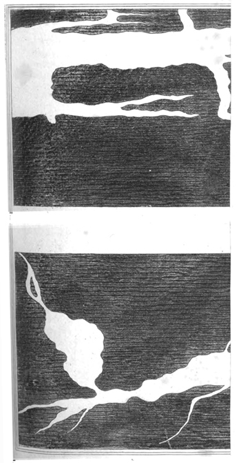
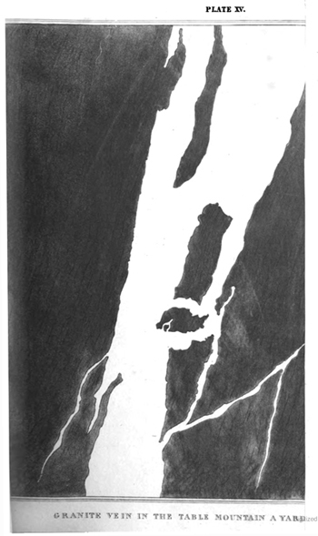
and stretching from east to west, which is nearly the direction of the mountain. It was not always easy to ascertain, which way these beds inclined. They were often almost vertical, and in some places I found them inclining from the mountain. On looking forward a little higher up, I Saw another portion of rock that was also laid bare, and which appeared to be Granite. I had now no doubt of reaching in a few minutes the precise junction of the two rocks, and I ventured to predict to my companion, who was not a little surprised at the pleasure I seemed to feel on this occasion, that we should immediately see veins from the main body of the granite, penetrating into the rock on which we were now standing. In this I was not deceived; the contact was the finest thing of the kind I ever saw; the Windy Shoulder* itself not excepted. The number of veins that we could distinctly trace to the main body of the granite was truly astonishing; and the ramifications, which extended on every side, were of all sizes, from the breadth of two yards to the hundredth of an inch. Masses of killas, cut off entirely from the main body of that rock, floated in the granite, without numbers, especially near the line of contact, and the strata appeared there broken, disordered, and twisted in a most remarkable degree.
Near this place I found a mass of killas in a state of decomposition; it had crumbled away, and left the granite dykes with many of the slender ramifications standing. The word ramification does not, however, properly express the nature of these smaller dykes; which are not branches, but plates or thin slender walls. There is nothing here that might not be ex-
* The spot which Mr HALL refers to, is on the side of Loch Ken in Kirkcudbrightshire, and is remarkable for veins of Granite, of the same kind with those here described. An account of it will be found in the preceding part of this volume, p. 99.
pected, on finding a vein partly stript of the containing rock; but as a specimen of this sort had never occurred to me before, I thought it worth mentioning.
From this point, following up the course of the stream for about 300 yards, I found the whole a solid mass of granite. The granite is characterised by large crystals of felspar, which, indeed, is true of all the granite which I met with at the Cape. Besides quartz and mica, large masses of hornblend enter occasionally into the composition of this rock.
After ascending about 300 yards farther, I came to a line where the granite ceased, and was succeeded by strata of superincumbent Sandstone. These strata were horizontal, and without any symptom of disturbance or violence whatsoever. There was not a shift nor a vein; and this junction formed a most marked contrast with that which we had left below.
Looking round from the point where I now stood, to all the parts of the amphitheatre, in the centre of which I was placed, I could trace the same line of junction, extending horizontally on every side.
From this point, where the sandstone was first discovered, for about 150 or 200 feet perpendicular, the rock continued of the same kind, viz. a red sandstone, in horizontal beds of no great thickness. From thence all the way to the summit the sandstone was of a much more indurated kind, quite white, and having pieces of water-worn quartz imbedded in it, from the size of a pea to that of a potatoe. The top is a plane of about ten acres, somewhat uneven, though, on the whole, nearly level. The weather acting very powerfully in this exposed situation, has worn holes, and laid open the strata in some places to a considerable depth; and the cement of the sandstone being softer than the included masses of quartz, these last, when they are exposed at the surface, are always pre-
sented with considerable relief. From the same cause, the bottom of every excavation is covered with a little beach of quartz pebbles, which have belonged to strata now worn away.
The day was remarkably fine, so that the prospect from the top of the mountain could hardly be seen to greater advantage than at this moment. It was, indeed, uncommonly grand, and the interest was heightened by the novelty of the objects, and, perhaps, not a little by the reflection, that the point on which we stood is so remarkable in the constitution of the earth's surface, and so memorable in the history of nautical discovery. A carpet of the richest heath embellished the summit, and I sadly regretted, that my knowledge of botany was not sufficient to enable me to describe the beautiful varieties of that plant for which the Cape is so justly celebrated.
The same structure that is found in the Table Mountain, extends to two others in its vicinity; particularly the upper part of the Lion's Head, which consists of sandstone. Under the sandstone is found granite; and on the
north side, when you descend farther, you come to killas in vertical beds, which extend farther to the eastward, forming the Lion's Rump, where the strata are not, strictly vertical, but incline to the north, at an angle of about 8° from the perpendicular; their direction or stretch is across the peninsula, or from east to west, as at the Table Mountain. I had not time to undertake a particular examination of the Devil's Peak. The upper part of it is certainly composed of sandstone; the junction of which with the granite is distinctly visible from many places.
The same structure, with the variation of some circumstances, seems to take place all over the peninsula. The line or the junction of the granite and the sandstone, lowers in its level, however, as you approach the southern extremity, and the
killas at last disappears entirely. I uniformly found the rock, which the sea washed towards the south part of the peninsula, to be granite, and five or six yards higher was the sandstone. That which lay next the granite, was the red, as before, and above that was the white and more indurated sandstone; nor did it seem that there was much difference between the thickness of the sandstone mass here and at the Table Mountain. I must not omit to remark, that at the entrance of Simon's Bay, a creek in the west side of False Bay, where our ship lay, there rose from the sea an oblong rock of granite, about ten yards long, four or five yards wide, and eight or ten feet high, called Noah's Ark: abreast of this, on the beach, I found two whin dykes, a foot wide each, cutting the granite.
"Were it not," continues Captain HALL, "too great presumption in me to step out of the province of simple description, to wander in the regions of theory, I would propose as a conjecture, That the great mass of Sandstone which forms the summit of the Table Mountain, and of all the hills in the peninsula, had been raised from its original horizontal position, to the elevated situation it at present occupies, by the Granite forcing it up from below; that the rest of the peninsula had been raised in the same manner, but not so high, or that it had been lifted up a little more on the east side than the west. The highly inclined position of the killas, at the base of the Table Mountain, and the disjointed nature of its junction with the granite, seem conclusive as to its having undergone a great change; while the veins of granite which traverse the strata, both by their appearance when they insulate the fragments of killas, and by their minuteness of ramification, seem to have been in a state of fusion, accompanied by very considerable violence."
Thus far Captain HALL; and the concluding remark, so far from requiring apology, seems to me a very fair interpretation of the phenomena he has described. Conformably to this view of the matter, I would only farther remark, that the phenomena here described point out two separate epochas, distinguished by very different conditions of the substances which now compose the peninsula of the Cape. That peninsula, it now appears, is a wall of granite, highest at the northern extremity, and lowering gradually to the south; faced, at its base, with grauwacky, and covered, at its top, with a platform of horizontal sandstone. The penetration of the killas or grauwacky, by veins from the mass of granite which it surrounds, proves that the killas, though the superior rock, is of older formation than the granite. The granite, therefore, is a mineral that has come up from below into the situation it how occupies, and is not one of which the materials have been deposited by the sea in any shape, either mechanical or chemical. It is a species, therefore, of subterraneous lava, and the progeny of that active and powerful element, which we know, from the history both of the present and the past, has always existed in the bowels of the earth.
The introduction of the granite into the situation it now occupies, must have taken place while the whole was deep under the level of the sea: this is evident from the covering of sandstone which lies on the granite, to the thickness of 1500 feet; for there can be no doubt whatever that this last was deposited by water. After this deposition, the whole must have been lifted up, as Captain HALL supposes, with such quietness and regularity, and in so great a body, as not to disturb or alter the relative position of the parts. Thus the granite is shewn, I think with great probability, to be newer than one of the rocks incumbent on it, and older than the other. I know not that we have ever before had an example of a fact which so directly ascer-
tains the place which granite really occupies, in respect of the other parts of the mineral kingdom; it is one that from analogy might be expected to take place, and it is highly favourable to the opinion, that granite does not derive its origin from aqueous deposition. It seems, indeed, to be an instantia crucis, with respect to the two theories concerning the formation of rocks.
The sandstone, which covers the granite at the Cape, has the appearance of being a very extensive formation, and is probably a part of the same which BARROW, LICHTENSTEIN, other travellers, have mentioned as composing many of the principal mountains over a great tract of Southern Africa. tenuity of the parts holding together large masses of that and indicating a singular approach to equilibrium between the causes that produce, and those that resist decay, was observed on the summit of the Table Mountain, as already mentioned; and similar appearances excited the surprise of the two travellers just named, in some of the most inland tracts which they visited.
Plates XIV. and XV. are representations of veins of granite connected with the main body of that rock, and penetrating into beds of killas or grauwaky, which are nearly vertical.