[map]
[page 1]
A
CHRONOLOGICAL HISTORY
OF THE
DISCOVERIES
IN THE
SOUTH SEA
OR
PACIFIC OCEAN.
PART I.
Commencing with an Account of the earliest Discovery of that Sea by Europeans, And terminating with the Voyage of SIR FRANCIS DRAKE, in 1579.
ILLUSTRATED WITH CHARTS.
BY JAMES BURNEY,
CAPTAIN IN THE ROYAL NAVY.
LONDON:
PRINTED BY LUKE HANSARD, NEAR LINCOLN'S-INN FIELDS, AND SOLD BY
G. AND W. NICOL, BOOKSELLERS TO HIS MAJESTY, PALL-MALL; G. AND J. ROBINSON, PATERNOSTER ROW; J. ROBSON, NEW BOND-STREET; T. PAYNE, MEW'S-GATE; AND CADELL AND DAVIES, IN THE STRAND.
1803.
[page 2]
[page i]
TO THE
RIGHT HONOURABLE
SIR JOSEPH BANKS, BART. K. B.
ONE OF HIS MAJESTY'S MOST HONOURABLE PRIVY COUNCIL, PRESIDENT OF THE ROYAL SOCIETY, &C. &C.
SIR,
THE volume, which I have the honour to offer to Your notice, is intended as a contribution towards the advancement of a plan for a Digest of Maritime Geographical Discovery; a work which has long been wanted, and which every addition to the general stock renders more necessary.
Carefulness of arrangement is seldom to be found in the early collections of travels. These collections are, in general, to be regarded rather as valuable repositories, than as containing any regular series of information. Our countryman, Hakluyt, deserves to be excepted from this remark: perhaps there is no general collection wherein the compiler has been more studious of method. Indeed, the necessity for method
b
[page] ii
did not formerly exist in the same degree as at present. A single volume might then have contained nearly all the published relations worth preservation, of those who had travelled 'by land or by water.' The words voyage and journey, were then used as synonymous terms; and it is but of late, that they have acquired separate and appropriate meanings. A Spanish book is entitled, " A Diary of the Voyages of King PHILIP V. from Versailles to Madrid, and his Journey to Naples*:" though King PHILIP went by land to Madrid, and by sea to Naples. At the present time, in France, every traveller is called, un voyageur. With books, as with men, when the numbers of a community increase, distinctions become necessary, and sometimes, as in this case, separation. The most obvious and natural, was that marked by the elements: travels by land, and those by sea, we now scarcely consider as undertakings of the same species; the name of journey is given exclusively to the former, and of voyage to the latter; and the distinction is become the more strongly established in Great Britain, from its being so peculiarly a maritime country.
The accounts of voyages now in the possession of the public, are alone sufficient, both in number and in quantity, to form a considerable library. The length to which some of the relations have been extended, especially those of a modern date, and the want of any general arrangement, are become
* Diario de Viajes de el Rey Philipe V., desde Versailles a Madrid; y Jornada a Napoles.
[page] iii
vexatious obstructions to the acquisition of knowledge in maritime geography.
The utility of method and compression, to prevent irregular exuberance in so important a branch of science, is evident beyond contradiction. The manner in which the attempt may be made with the best prospect of success, seems the only object of enquiry. Various modes of reducing the voyages into methodical order present themselves; and probably each so far eligible as to possess some peculiar advantage.
To place the whole in the order of time, would be attended with this great inconvenience, that to obtain a satisfactory account of any one subject, it might be requisite to consult every volume in the collection, however extensive.
To distinguish the discoveries of different nations, making a distinct class of the voyages of each, is liable to the same objection.
A third method, which seems to me to possess many, if not the greatest advantages, is that of classing the voyages according to some hydrographical division of the globe. This has been attempted, but in few instances with any tolerable degree of success. If the divisions have been judiciously allotted, they have not been strictly preserved. The same irregularity has prevailed in collections which consist wholly of republications, where it is difficult to imagine that any good reason could exist against an adherence to correct arrangement.
b 2
[page] iv
Among modern collections, one of the most full, and the most regular, is the Histoire General des Voyages of M. Prevot, the foundation of which was laid by Astley. M. Prevot undertook more than could be performed with accuracy, as every man will discover who undertakes the whole. The earlier volumes required to be supplied by additions and amendments in those afterwards published, by which the subject is much dispersed. The Histoire General des Voyages is nevertheless a most valuable work, and there is reason to be astonished that so large a mass of geographical information should have been so well compiled and published by the exertions of any individual; and the irregularities in the collection are much atoned for by a copious and good index.
To form a complete History of Voyages, is an undertaking that would require, for a great number of years, the labour and united efforts of many able associates. In such an employment, a rapid progress is scarcely compatible with correctness, and especially in those parts where it is thought necessary to compress and consolidate many accounts into one. By compression, is not to be understood the vicious practice of curtailing, in the generality of what are called abridgements; a practice ill adapted to works designed for information.
With respect to nautical remarks, some are involved with the most interesting incidents of a voyage; and some few are, independent of all other circumstances, of more real importance, as well as more satisfactory to curiosity than any incident of the narrative. But it must be acknowledged, that a great part of the nautical remarks in many voyages are not within either of the above descriptions; and the reader cer-
[page] v
tainly has sufficient reason to complain, when he finds the relation of a voyage greatly swelled with minute accounts of days works, lunar observations, &c. even in known seas, and when far distant from land; as if it were a matter of importance to settle the exact geography of a spot in the middle of the ocean, where no mark exists by which it can be ever recognised.
To remedy this, by striking out any part of what is useful, is to exchange superfluity for defect. Many have supposed that to abridge, is a work of no labour; that to read and reject such parts as are disapproved, is nearly the whole that is required: the consequence has been, that abridgements have been undertaken by persons very inadequately skilled in the subject of which their original consisted. Many things that are justly objectionable, cannot be wholly omitted without leaving a chasm: to furnish the necessary explanation on such an occasion, may require both labour and experience; for where the task is carelessly or unskilfully performed, an abridgement is of no use: when information shall be wanted, recourse must be had to the original authority.
To form a complete account of any voyage, it is necessary that no incident, remark, or observation, in any former relation, shall be omitted which can be in the least serviceable to science, which can excite interest, or satisfy curiosity: and to state every thing remarkable or extraordinary, however useless or incredible; with, occasionally, an observation on the degree of credit to which it appears entitled. It is likewise satisfactory, that many things, which appear of little use and uninteresting, should be noticed, though only a single line be
[page] vi
bestowed on them; and not always the less satisfactory for their being noticed with brevity. In short, every thing should be mentioned which possesses any prospect of utility, and the quantity of remark may be proportioned to the importance and to the occasion; avoiding to seek brevity at the expense of the more valuable qualities of information or interest.
All this might be admitted, and the accounts of voyages be yet greatly compressed, and at the same time enriched.
It is not to be supposed that any mode of arranging the subject could be devised, which would obviate every inconvenience. The following division is proposed as one which appears capable of preserving its classes in a great measure distinct from each other.
The first class may contain the voyages to the North of Europe; those in the North seas, and towards the North pole.
The second, those along the West coast of Africa to the Cape of Good Hope; and the discoveries of the Atlantic Islands.
The third, East from the Cape of Good Hope to China, including the Eastern Archipelagos between New Holland and the coast of China. Japan might have a section to itself as a supplement to this class.
The fourth might contain the whole of the discovery of the East side of America, except the Strait of Magalhanes and
4
[page] vii
of Le Maire, which are more connected with the voyages to the South Sea.
The fifth class may comprehend the circumnavigations and voyages to the South Sea. With these, the discoveries on the West coast of North America are so much interwoven, that they cannot, without disadvantage, be separated.
The discoveries made by the Russians in the seas near Kamtschatka, and from thence to the North, would appear not improperly as a supplement to the fifth class.
New Holland might form a sixth class. This country would naturally have divided itself between the third and fifth, had not its importance so much increased within the few last years, that it now requires a distinct class to itself.
The foregoing division is offered as a sketch for a general plan: the classes are capable of modification, according to the convenience or inclination of those who may undertake any part of the task; and, in each, chronological order might with ease be preserved.
An inconvenience to which the plan here suggested may be liable, is, the necessity for repetition which must sometimes occur. To place each particular of information in its respective class, is the method most adapted to useful purposes; yet the voyages must not be broken or disjointed; for by such a process, too much of their interest would be sacrificed. Captain Cook's discovery of the East coast of New Holland could not be spared, either from the account of his voyage, or from a
[page] viii
history of the discovery of New Holland. Other similar instances must occur; but such repetitions would bear a very small proportion to the whole. It might be necessary, however, in a complete collection, when a voyage of any class contained information that also belonged and was material to another class, to make a transfer; substituting, in lieu of the information transferred, a brief, but complete, abstract, with a reference to the place where the fuller description was to be found. For instance, the island of Madeira is described in many voyages of a more distant class. All those descriptions might be collected, and placed in regular order immediately following the account of the discovery of Madeira; and in the part from which the description is taken, the vacancy might be supplied by an abstract and reference, which, as the incidents belong exclusively to the narrative, would leave no chasm; the recapitulation so managed would occupy too small a space to attract notice; each class would be rendered entire, and the accounts of voyages would not sustain injury.
It is a material advantage in regular arrangement, that it affords encouragement and facility to such an undertaking. In a geographical division, each class forms of itself a complete head of discovery; and by being separately considered, the attention of the writer is more concentrated to one point.
For the subject of the present work, I have chosen the discoveries made in the South Sea, to which my attention has been principally directed, from having sailed with that great discoverer and excellent navigator, the late Captain Cook;
[page] ix
under whose command I served as Lieutenant in his two last voyages.
And here, Sir, it is proper to explain my motives for addressing you on this occasion.
Independent of the wish natural to an author to obtain such countenance as he believes will stamp the most estimation on his performance, I am desirous, on many accounts, to recommend my work particularly to your notice. You have visited, and are well acquainted with the scenes I am endeavouring to describe. To you my plan was first communicated, and the encouragement it received from you, determined me to the undertaking. You indulged me with the most unrestrained use of your valuable library; not merely with access, but with permission to take away, for more deliberate consideration, whatever appeared connected with my pursuit; thus rendering it, to all purposes of utility, my own. To these reasons I may justly add, that, next to His Majesty, you have been one of the greatest patronisers and promoters, in this or in any country, of Geographical Discoveries.
To Mr. Dalrymple I have been greatly indebted for assistance. From his large collection of scarce Spanish books, I have been furnished with several original accounts of Spanish discoveries, which I had no other means of procuring. Much labour has likewise been saved me by his "Historical Collection of Voyages and Discoveries in the South Pacific Ocean;" a work which, besides giving a clear outline of the subject, has been extremely useful as an index to direct
c
[page] x
me to original information. It has, indeed, been my Vade Mecum.
It is with great satisfaction I am enabled to state, that the outline of my plan for a General History of Maritime Discovery had the entire approbation of Major Rennel. Let it not be supposed that in saying this, I intend to insinuate any recommendation of the performance of that part which I now submit to the public. The merits of a plan and of its execution are to be decided separately; and very inexperienced must be the reader who encourages himself to expect that every work will fulfil the intention of its author.
I have been favoured by Mr. Arrowsmith with many useful communications, which his knowledge in modern geography, and the materials he has collected concerning the more recent navigations an the Pacific Ocean, so well enabled him to impart.
It might be considered as an omission not to notice that the Histoire des Navigations aux Terres Australes, by M. De Brosses, is similar in plan, and still more so in the extent of its design, to the work which I have undertaken. It is, however, very evident, that the principal object of M. De Brosses, was to explain the advantages of distant colonies, and to recommend the settlement of lands discovered in the Southern hemisphere. His book, considered as a geographical work, affords no proof of laborious research. His information in this respect, appears to have been collected with haste, and adopted without examination. His division of the Southern discoveries into Magellanique, Australasie, and Polynèsie, is
[page] xi
methodical, and clear for the purposes of description; but could not be preserved in narrative, as is evident from the most cursory perusal of M. De Brosses's work. The names likewise are objectionable; inasmuch as they give an appearance of technical obscurity to his subject, keeping the reader at a mysterious distance.
His Table of Contents is well contrived to exhibit, in small space, a general and comprehensive view of all the navigations performed in the different divisions of his subject. It is to be regretted, that this author had so light an opinion of the importance of the task of registering and methodizing geographical information, and has not bestowed on it more of his labour and attention.
The geography of the South Sea has much greater obligations to M. Fleurieu for his Treatise on the Discoveries to the South East of New Guinea. Zeal for the reputation of France has sometimes carried him into discussions not necessary to his subject; but in the more material parts of his work, there is much diligent investigation and comparison, and his labours in this, and in other publications, throw much light on the discoveries made in that part of the globe.
The form of the ensuing History was not a matter of reflection or choice; the subject without premeditation fell into that shape; and, with a few slight deviations from chronological order, it has been found capable of preserving the integrity of each voyage distinct and unmixed with other matter.
How far the account I now offer of the discoveries to the time of Sir Francis Drake's circumnavigation maybe defective,
c 2
[page] xii
I know not: I have searched all the materials within my reach, and I have been fortunate in obtaining access to most of the works from which I had reason to expect original information.
In digesting what I found, I have endeavoured to preserve the most striking features of the different narratives I had occasion to consult; and have been especially careful that no geographical notices of any value should be neglected.
Having thus explained my design, I submit my performance to your judgment without further comment; assured as I am, that every attempt to convey useful information, will experience from you favourable attention.
I have the honour,
SIR,
To subscribe myself,
With the most sincere
Respect and Esteem,
Your greatly obliged and
Obedient Servant,
James Burney.
[page xiii]
CONTENTS.
CHAPTER I.
Introductory; containing a brief Account of the Discoveries made in the South Sea, previous to the Voyage of MAGALHANES.
| Page | |
| Line of boundary of the South Sea or Pacific Ocean | l, 2 |
| Columbus, his motives and opinions | 2, 3 |
| Meridian of Partition | 3 |
| Expedition of the Cabots | 4 |
| Corte Real | ib. |
| Strait of Anian | 5 |
| Americus Vespucius | 6 |
| Discovery of R. de la Plata | 7 |
| Discovery of the Sea to the West of America | 8 |
| Name SOUTH SEA | 9 |
| Juan de Solis | 10 |
| Islands de las Perlas | ib. |
| Schemes for sailing Westward to the Moluccas | 11 |
CHAP. II.
Voyage of FERNANDO DE MAGALHANES.
| Page | |
| Arrival of Magalhanes at the court of Spain, and his proposals | 13 |
| Terms of agreement with the emperor Charles V. | 15 |
| Original accounts remaining of the voyage | 16, 18 |
| His departure from Spain | 19 |
| At Brazil | 20 |
| Rio de la Plata | 22 |
| Port San Julian | 25 |
| Mutiny of the fleet | 27 |
| Rio de Santa Cruz, discovery of | 31 |
| Wreck of the Santiago | ib. |
| Natives at Port San Julian | 33 |
| The Guanaco | 34 |
| The natives named Pata-gones | ib. |
| Treachery of the Europeans | 35 |
| Description of the Patagonians | 36 |
| Short vocabulary of their language | 37 |
| Cape de las Virgenes | 39 |
| A strait discovered | ib. |
| Tierra del Fuego | 41 |
| Magalhanes enters the South Sea | 43 |
| Desertion of the St. Antonio | ib. |
| Passage in Pigafetta's narrative | 45 |
| Island San Pablo | 48 |
| Island Tiburones | 49 |
| The name Pacific given to the South sea | 51 |
| Observations on the track of Magalhanes across the South Sea | ib. |
| The Ladrones | 57, 59 |
| Humunu, Zuluan | 60 |
| Archipelago of St. Lazarus | ib. |
| Mazagua | 61 |
| Zebu | 65 |
| Battle at Matan | 77 |
| Death of Magalhanes | 78 |
| His character | 79 |
| Circumnavigation of the globe completed by him | 80 |
d
[page xiv]
CHAP. III.
Sequel of the Voyage after the Death of MAGALHANES.
| Page | |
| Massacre of the Spaniards at Zebu | 83 |
| Bohol | 84 |
| Mindanao | 85 |
| Cagayan Sooloo | ib. |
| Puluan | 86 |
| Borneo port and city | 87 |
| Sensitive tree | 93 |
| Zolo Islands: pearls there | 94 |
| Tidore | 97 |
| Spices produced at the Moluccas | 100 |
| The clove tree | 101 |
| Bird of Paradise | 105 |
| The ship Vitoria sails for Europe | 106 |
| Timor | 110 |
| St. Jago | 111 |
| Arrives in Spain | 112 |
| Attempt of the Trinidad to sail from the Moluccas to New Spain | 115 |
| Advantages of the Voyage of Magalhanes to Geography | 118 |
CHAP. IV.
Progress of Discovery on the Western coast of America, to 1524; Disputes between the Spaniards and Portuguese, concerning the Spice Islands. Attempt to discover a Strait near the Isthmus of Darien.
| Page | |
| Hernando Cortes sends ships along the Western Coast of New Spain | 119 |
| Junta de Badajoz | 122 |
| Attempt of Gomez | 124 |
CHAP. V.
Voyage of GARCIA JOFRE DE LOYASA, from Spain to the Moluccas. Discovery of the North Coast of Papua, by the Portuguese. Voyage of ALVARO DE SAAVEDRA, from New Spain to the Moluccas.
| Page | |
| Loyasa sails from Convnna | 129 |
| Island S. Mateo (St. Matthew) | ib. |
| Cape de las Virgenes | 131 |
| Wreck of Del Cano's ship | ib. |
| Discovery of Land to the South | 133 |
| Natives in the Strait of Magalhanes | 135 |
| Four ships enter the South Sea | 136 |
| One sails to New Spain | 137 |
| Death of Loyasa and Seb. del Cano | ib. |
| Island San Bartolome | 138 |
| At the Ladrone Islands | ib. |
| Mindanao | 140 |
| Island Polola | ib. |
| Talao | 142 |
| Zamafo | 143 |
| Molucca Islands. Tidore | 144 |
| North Coast of Papua discovered by the Portuguese | 145 |
| Menusu, Bufu (Dos Graos) | ib. |
| Islands de Sequeira | 146 |
| Saavedra sails from New Spain | 148 |
| Discovers Islands los Reyes | ib. |
| Arrives at the Moluccas | 150 |
| Sails thence for New Spain | 151 |
| Land of Papua | ib. |
| Returns to the Moluccas | 153 |
| Sails a second time for New Spain | ib. |
| Islands Los Pintados | 154 |
| Los Buenos Jardines | 155 |
| Death of Saavedra | 157 |
| The ship returns to the Moluccas | 158 |
| The Spaniards abandon the Moluccas | 160 |
[page xv]
CHAP. VI.
Various other Expeditions between the Years 1526 and 1533, each inclusive. Discoveries on the Western coast of America. Discovery of California.
| Page | |
| Sebastian Cabot to Brazil | 162 |
| Ships of Villegagnon | 163 |
| Passages across the Isthmus of Darien | ib. |
| First Spanish town built in Peru | 164 |
| Ships sent by Cortes discover California | 168 |
| Island Santo Tomas | 169 |
CHAP. VII.
Expedition of Simon de Alcazova. The Spaniards penetrate to the South from Peru.
| Page | |
| Alcazova sails from San Lucar | 171 |
| Island de la Trinidad | ib. |
| He quits the Strait and sails to P° de Leones | 174 |
| Expedition of his people inland | ib. |
| Alcazova killed | 175 |
| City of Los Reyes built | 176 |
| Almagro marches into Chili | ib. |
CHAP. VIII.
The Marquis Del Valle sails to California. Voyage of Hernando de Grijalva, and Alvarado, from Peru to the Moluccas. Voyage of Alonzo de Camargo from Spain to Peru.
| Page | |
| Cortes sails to California, and forms a settlement there | 177, 178 |
| The settlement abandoned | 179 |
| Voyage of Grijalva and Alvarado | 180 |
| Remarks on Galvaom's account of their Voyage | 184 |
| Guedes or Joseph Freewill's Islands | 185 |
| Voyage of Al. de Camargo | 186 |
CHAP. IX.
Relation given by Marcos de Niza, of his Journey to Cevola. Discovery by Francisco de Ulloa, that California was part of the Continent.
| Page | |
| Cevola or Cibola | 191, 192 |
| Voyage of F. de Ulloa | 193 |
| He discovers California to be part of the Continent | 199 |
| Ancon de San Andres | 202 |
| Isle de Cedros | 206 |
d 2
[page xvi]
CHAP. X.
Continuation of the Discoveries to the North of Mexico. Expedition of Hernando de Alarcon, and of Francisco Vasquez de Cornado.
| River de Buena Guia | Pages 212, 2l6 |
CHAP. XI.
Schemes for Maritime Expeditions, formed by Pedro de Alvarado. They are frustrated by Ms Death. Voyage of Juan Rodriguez Cabrillo, to the North of California.Establishment of the Spaniards in Chili. The Coast of Japan seen for the first Time by Europeans.
| Page | |
| Death of Pedro de Alvarado | 220 |
| Plans he had formed | ib. |
| J. Rod. Cabrillo sails from New Spain | 221 |
| Cape de Fortunas | 223 |
| Santiago the first town built by the Spaniards in Chili | 225 |
| Japan seen for the first time by Europeans | ib. |
CHAP. XII.
Voyage of Ruy Lopez de Villalobos.
| Page | |
| Track of Villalobos from New Spain to Mindanao | 228, 232 |
| Sto Tome. La Annublada. Roca partida. De los Reyes. Los Corales. Los Jardines. Matalotes. Arrccifes | 228, 233 |
| Mindanao. Sarrangan | 234 |
| The San Juan sails for New Spain | 236 |
| Name Las Philippinas given | ib. |
| Villalobos sails to the Moluceas | 237 |
| The Navigation of the San Juan | 238 |
| Islands: Abriojos, Dos Hermanas, Los Voleanes, Forfana | 239, 240 |
| Second attempt of the San Juan | 241 |
| Land of Papua named New Guinea | ib. |
| Villalobos departs from the Moluccas | 243 |
| His death | ib. |
CHAP. XIII.
Events connected with Maritime Expeditions in the South Sea, to the Year 1558. Ships sent to examine the American Coast to the South from Valdivia. Juan Ladrilleros to the Strait of Magalhanes.
| Page | |
| Preparations for the conquest of the Philippines | 244 |
| City of Valdivia founded | 245 |
| Schemes of P. de Valdivia | 246 |
| He sends two ships to the Straits | ib. |
| Voyage of J. Ladrilleros From Valdivia | 247 |
| He arrives in the Strait | 248 |
| Proceeds to the east entrance, and returns, | ib. |
5
[page xvii]
CHAP. XIV.
Expedition of Miguel Lopez de Legaspi, from New Spain to the Philippine Islands.
| Page | |
| Sails from Navidad | 252 |
| Island de los Barbudos | 253 |
| Islands de los Plazeres | ib. |
| I. de Paxaros | ib. |
| Las Hermanns | ib. |
| Arrival at the Ladrones | 254 |
| At the Philippines. Tandaya | 258 |
| Abuyo. Mazagua | 263 |
| Camiguin. Bohol | 264 |
| Zebu | 266 |
| P. Urdaneta sails for New Spain | 269 |
| Arrives at Acapulco | ib. |
| His route | 270 |
| Zebu submits to the Spaniards | 271 |
CHAP. XV.
Of the Islands discovered near the Continent of America in the Pacific Ocean.
| Page | |
| Islands Juan Fernandez and Mas-a-fuera | 274 |
| The Galapagos | ib. |
| Malpelo. Cocos Island | 275 |
CHAP. XVI.
Discovery of the Salomon Islands, by Alvaro de Mendana.
| Page | |
| Isle de Jesus | 278 |
| Baxos de la Candelaria | ib. |
| Santa Ysabel | ib. |
| A brigantine built, and sent on discovery, | 279 |
| Many islands discovered | 279, 280 |
| The brigantine sails round Santa Ysabel | 281 |
| Guadaleanar | 282 |
| The Island San Christoval | 283 |
| Santa Catalina and Santa Ana | 284 |
| Mendana sails for New Spain | 285 |
| Island San Francisco | ib. |
| Returns to Lima | 286 |
| Reports concerning another voyage | ib. |
| Remarks on the situation of the lands discovered by Mendana | 287 |
[page xviii]
CHAP. XVII.
Progress of the Spaniards in the Philippine Islands. The Islands San Felix and San Ambor discovered. Enterprise of John Oxnam, an Englishman, in the South Sea.
| Page | |
| City of Manilla built | 292 |
| Islands S. Felix and S. Ambor | ib. |
| Oxnam crosses the Isthmus of Darien | 294 |
| Builds a vessel and sails into the South Sea | 296 |
| His adventures | 296, 299 |
CHAP. XVIII.
Reports concerning the Discovery of a Southern Continent.
CHAP. XIX.
Voyage of Francis Drake round the World.
| Page | |
| Sails from England | 305 |
| Mogadore | 306 |
| Cape Blanco | 308 |
| Islands: Mayo, Brava | 309 |
| Rio de la Plata | 310 |
| Bay of Seals | 313 |
| The natives there | 313, 316 |
| Port San Julian | 317 |
| Trial of Thomas Doughtie | 320 |
| Three ships pass the strait | 325 |
| They are separated | 326 |
| Southernmost part of Tierra del Fuego discovered | 327 |
| Island Mocha | 329 |
| Valparaiso | 331 |
| Callao | 335 |
| Rich Spanish ship captured | 338 |
| Island Canno | 339 |
| Guatulco | 341 |
| New Albion | 342 |
| Of the situation of Port Drake | 354 |
| Islands of St. James | 355 |
| Drake leaves the coast of America | 356 |
| Islands of Thieves | 357 |
| Islands near the east of Mindanao | ib. |
| Sarangan and Candigar | ib. |
| Molucca Islands. Terrenate | 358 |
| Crab Island near Celebes | 361 |
| The ship on a rock | 362 |
| Extraordinary escape | 363 |
| Java | ib. |
| Arrival at Plymouth | ib. |
| Account of the Elizabeth | 367 |
| The Shallop | 368 |
| The Marigold | 369 |
[page xix]
CHAP. XX.
| Some Account of the Charts to this Volume, with Miscellaneous Observations on the Geography of the 16th Century. Evidence in favour of the Probability that the Country, since named New Holland, was discovered by Europeans within that Period | 370 |
APPENDIX.
| Remarks on the Projection of Charts, and particularly on the Degree of Curvature proper to be given to the Parallcls of Latitude | 383 |
ERRATA.
| Page | 39, | line 19, and in margin. | for Virgines read Virgenes, |
| 102, | line 4, | for where read whither. | |
| 109, | in margin, | dele Timor. | |
| 113, | line 11, | for circumdediste read circumdedisti. | |
| 121, | line 10, | for douple read double. | |
| 157, | line 18, | for Cortez read Cortes. | |
| 181, | line 9, | for no tact read not act. | |
| 225, | in the last paragraph, | for seen on their coast anchored before Awa,, oppsite the island Tsikok, read had been seen in Awa on the island Tsikok, lying opposite. | |
| [The passage, as it is printed in p. 225, was taken from Schenchzer's translation of Kæmpfer's History of Japan. In the original, the fact is stated as in the correction.] | |||
| 306, | in note *, | for the same read similar. | |
| 329, | line 14, | insert an inverted comma. |
[page xx]
DIRECTIONS FOR THE BINDER.
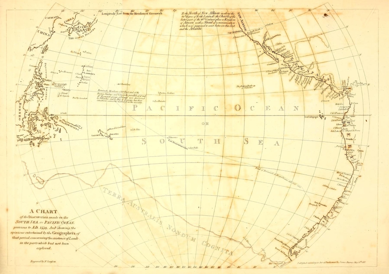
| A Chart of the Discoveries made in the South Sea or Pacific Ocean | To face the Title. |
| Sketch of the Salomon Islands | To face page 277. |
| Chart of the Southern Parts of America | |
| Chart of the Philippine and Molucca Islands | After page 382, and before the Appendix. |
| Chart of California and the Gulf |
[page 1]
A
HISTORY
OF THE
DISCOVERIES
IN THE
SOUTH SEA.
CHAPTER I.
Introductory; containing a brief Account of the Discoveries made in the South Sea, previous to the Voyage ofMAGALHANES.
MOST of the names which have been assigned to the different portions of the Ocean, are descriptive either of the climate, situation, or of some quality peculiar to the sea they are intended to designate. The names, South Sea, and Pacific Ocean, are both of a characterising nature: but it will appear that their application has been extended far beyond every signification of the words which the most liberal construction can allow, and equally beyond the space for which they were originally intended, to limits which, till within the last thirty years, remained undiscovered.
The line of boundary which seems designed by nature for this great sea, is formed, on its Eastern part, by the Western
B
[page] 2
coast of America, taken from its Southern extremity (Terra del Fuego) to the shore near mount St. Elias, in 60 degrees North latitude. The northern limits are marked by the continuation of the American coast from mount St. Elias towards the West, "with the chain of islands called the Fox and the Aleutian islands. The western boundary may be described by a line drawn from the Cape of Kamtschatka (Cape Lopatka) towards the South, passing by the Kurili islands, and the Eastern coast of the Japan islands; from thence by Formosa, and along the East of the Philippines; by Gilolo; by the North and eastern coast of New Guinea; and by the East coast of New Holland, to the South-east cape of Van Demen's land.
Considering the present state of science in our quarter of the globe, it is scarcely possible to reflect, without astonishment, that the whole of this great expanse of ocean, and even its existence, three centuries ago was unknown to Europeans: for though Marco Polo, in the 13th century, gave notice of the existence of a sea Eastward of China, his information did not reach within the limits above described.
1492.
The expectation of being able to sail Westward from Europe without interruption, to the Spice islands, appears to have been the principal inducement of COLUMBUS in undertaking, and of the Spanish court in promoting, the celebrated voyage which first marked the western limits of the Atlantic ocean, and made known to Europeans another continent. The most esteemed geographers of that time were of opinion, and have so represented it in their maps, that from the Western shores of Europe and Africa, to the eastern part of Asia, the whole space was, with the exception of some islands, a continued open sea; Asia being then believed to extend much more towards the
[page] 3
East than experience has since shewn*. The discovery of America opened a new field for enterprize, and with such powerful attractions, as for a time to eclipse the original object, and wholly to engross the attention of the Spanish adventurers. America, however, was not supposed to be of an extent to obstruct entirely the sailing West from Europe to the Eastern Indies; and the attempt to accomplish that navigation was soon renewed.
Meridian of partition.
Immediately after the discovery of what was then called a New World, Pope ALEXANDER the VIth, to prevent disputes between the Spaniards and Portuguese, respecting their titles to the possession of so many new countries, and no doubt partly in support of the maxim long inculcated, that the disposal of earthly kingdoms was a right inherent in the Papal See, issued a bull of donation, fixing as limits of partition, a meridian to be drawn 100 leagues West of the Azores and Cape de Verd islands; from which meridian, the bull granted
* Antonio de Herrera, in the beginning of his history of the Western Indies, has related the following anecdote of Columbus.
'Columbus reckoned, that as cosmographers had written of as much of the world as amounted to 15 hours, without having come to the eastern extremity, the end must consequently be yet farther; and the more it extended to the east, the nearer it must approach to the Cape de Verd islands. He was confirmed in this opinion by his friend Martin de Bohemia (i. e. Martin Behaim).'
Herrera, Dec. 1. lib. 1. cap. 2.
Major Rennel remarks, 'that the splendid discoveries of Columbus were prompted by a geographical error of most extraordinary magnitude;' the extent of China, and its distance to the east from Europe, being both so much magnified, that many at first imagined the new discoveries of Columbus to be a part of Asia.——Geographical System of Herodotus examined and explained, &c. p. 685.
Correspondent to the idea that Columbus, by sailing westward, had reached India, his new discoveries obtained that name. It afterwards became necessary to distinguish the India of the Ancients by the appellation of the Eastern India, and to bestow the addition of Western on the Modern India.
B 2
[page] 4
1494.
1497.
to the Spaniards dominion over all lands newly discovered, and to be discovered, as far as 180 degrees to the West: and to the Portuguese the same distance Eastward. At the instance of the Portuguese, with the consent of the Pope, in 1494, the line of partition was by agreement removed 270 leagues more to the West, that it might accord with their possessions in the Brasils*. Notwithstanding the generosity of Alexander the VIth, thus exclusively exerted in favour of Spain and Portugal, so early as the year 1497†, an expedition was undertaken by the English, which was conducted by the Cabots (John and Sebastian, father and son) who sailed in search of a passage to the North of the Spanish discoveries, but were stopped by the continent.
1500.
In the year 1500, Gaspar de Corte Real, a Portuguese, obtained leave of king EMANUEL to make a voyage for discovering unknown lands. He departed from the Azores with a de-
* On the latter adjustment, the Spaniards afterwards rested their claim to the Spice islands. The Spanish geographers reckoned from the island St. Antonio, the most western of the Cape de Verd islands. 370 Spanish leagues measured on the same parallel, (which seems to be the proper construction of the bull) is equal to 22 degrees of longitude, and would place the Meridian of Partition at 47° west from Greenwich. Argensola says, according to the terms of agreement between the monarchs of Spain and Portugal, the Meridian of Partition fell upon the country of Brasil, at the western part of the entrance of the river Maragnan. Herrtra, in the eharts to his Descrip de las Ind. Occidentales, has drawn it above a degree to the east of the same river. In Herrera's chart, the Meridian of Demarcation is placed 30° west from the first meridian, and the first meridian passes through Cape Verd. The opposite Meridian of Demarcation, supposed to be 180 degrees from the former, has been drawn variously, according to the opinions or views of the different geographers. Malacca was generally included by the Spaniards in their half, which comprehended, as later observations have shewn, not less than 213 degrees of the equator: a division to which the Portuguese did not subscribe.
† One account dates the expedition of Cabot in 1496.
Vide. Hakluyt, Vol. I. p. 6 and 7. edit. 1600.
[page] 5
sign similar to that of the Cabots, and pursued nearly the same track. He fell in with the eastern coast of Newfoundland, and sailed along that side of the island, till he arrived at its northern extremity, where, finding an opening to the West, he proceeded in that direction, till he came near the entrance of the river now called St. Laurence. Finding, in such a length of route, a clear sea before him, he concluded that he was in a passage or strait, which led to the Pacific Ocean; and returned to Lisbon, to communicate the news of his discovery, giving to the supposed strait the appellation of Anian*, it is said, after three brothers so named.
Corte Real's navigation is briefly noticed by several authors, who almost all vary from each other in the circumstances. Antonio Galvaom, who was his countryman, and nearly his contemporary, seems the best entitled to credit. He relates that Gaspar sailed a second time the same voyage, and was wrecked; but another ship that went in company with him, returned to Portugal. Miguel Corte Real, brother to Gaspar, fitted out three ships at his own cost, and went in search of his brother. They arrived at a part of the American coast, where there were several entrances of rivers and inlets. Each vessel took a different route, having previously agreed that they would meet again before the 20th day of August. Two of the ships rejoined each other at the appointed time: but the ship in which was the unfortunate Miguel was not again seen or
* The strait of Anian, formerly the subject of much geographical discussion has by some been supposed to have been so named after a province of China of the name of Ania, mentioned in the travels of Marco Polo: but in the charts of the 16th century, a passage is given to the sea round the north of America and Anian appears as a country on the north west part of that continent.
[page] 6
heard of*. On the return of the two ships to Portugal, Joaō Vasques de Corte Real, the eldest brother, who was chamberlain to king EMANUEL, would have undertaken a voyage in the hope of tracing his two brothers, but the king would not suffer him to embark in so hazardous an enterprise. The land called Labrador was named likewise the land of Corte Real, and the sea near the entrance of the river St. Laurence, was called the Gulf of the Three Brothers †.
1501.
In 1501, Americus Vespucius, a Florentine, then in the service of the king of Portugal, discovered along the coast of South America (not then so named) according to his own account ‡, 600 leagues to the South, and 150 leagues to the
* Tratado dos Dcscobrimentos, pelo Antonio Galvaom, p. 36. edit. 1731. Lisboa.
† Description du Nouveau Monde, Tirée des Tableaux Geographiques de Petrus Bertius.
‡ Letters of Americus Vespucius, in Ramusio's Collection, vol. i. fol. 128.
Americus Vespucius, a vain man, bnt an enterprising and good navigator, has been accused of constantly appropriating to himself the 'glory' of being the first European discoverer of the New Continent. Herrera, Dec. 1. 1. 4. c. 2.
Columbus saw the Continent in August 1498, not then suspecting it to be such; for having found so many large islands, this land was likewise supposed to be of the same description. By Vespucius, it was not seen before June 1499, when he was engaged in an expedition, of which Alonso de Ojeda was the chief commander.
In fact, the first Europeans who saw the main land of America, were the English, under the command of Cabot; and certainly Cabot might have advanced a claim in every respect superior to that of Vespucius. To Columbus, however, the great leader of the western navigation, and to him only, is Europe indebted for the knowledge of America: the discovery of the Continent was a necessary and certain consequence of the discovery of the West Indian islands; besides that he was the actual discoverer of South America.
In 1507 (the Admiral, Christopher Columbus, being dead) Americus Vespucius was taken into the service of the king of Spain, with the title of Pilot Mayor (chief pilot) and was employed in making charts of the new discoveries, which gave him opportunity to affix his own name to the land of South America. Don Diego, the son of Columbus, remonstrated against the disingenuous eonduct of Americus Vespucius [Herrera, Dee. 1. 7. 5.]: the name, nevertheless, not only remained, but has been extended to the whole of that Continent.
6
[page] 7
West, from Cape Saint Augustine: but it does not appear that he kept sight of the coast to so great a distance. In an edition of the geography of PTOLEMY, printed at Rome in the year 1508, there is a chart, an extract from which was lately published by Mr. Dalrymple, in which it is said that ships of the Portuguese had observed a continuance of the land to the South, as far as to 50 degrees of South latitude, without its there terminating. By this, it may be presumed, was meant the voyage of Vespucius: it is not however probable, that he followed the coast regularly so far as to Rio de la Plata; for that river was not known to Europeans till several years after his voyage. It is remarkable in this chart, that the name America does not appear. The land of Brasil is there called Terra Sancle Cruris, and is delineated as being separate from the northern continent.
1502.
Various attempts were likewise made by the Spaniards to penetrate farther to the West: one in particular by COLUMBUS himself in 1502, who, with that view, examined 370 leagues along the coast of that part of the continent, since known by the names of Terra Firma, and the Spanish Main.
1512.
In 1512, Juan de Solis, a Spaniard, discovered the great river de la Plata, which name was given to it on account of the quantity of silver there seen.
The knowledge that the eastern part of China was washed by the ocean, demonstrated the certainty of a sea to the west of the newly discovered continent: but the first actual information obtained by Europeans of this sea, was given to the
[page] 8
1513. Discovery of the sea to the West of America.
1513. Sept. 25.
Spanish conquerors by the native Americans. Basco Nunnez de Balboa, a Spanish commander at Darien, to verify the intelligence he had received, marched with a body of Spaniards, and with Indian guides, across the isthmus. He was opposed in the passage by the natives. They demanded who the bearded strangers were, what they sought after, and whither they-were going? The Spaniards answered*, 'they were Christians, that their errand was to preach a new religion, and to seek gold; and that they were going to the southern sea.' This answer not giving satisfaction, Balboa forcibly made his way. On arriving at the foot of a mountain, from the top of which he was informed that the sea he so anxiously wished to discover was visible; he ordered his men to halt, and ascended alone. As soon as he had attained the summit, he fell on his knees, and with uplifted hands returned thanks to Heaven, for having bestowed on him the honour of being the first European that beheld the sea beyond America. Afterwards, in the presence of his followers, and of many Indians, he walked up to his middle in the water, with his sword and target; and called on them to bear testimony that he took possession of the South Sea, and all which appertained to it, for the king of Castile and Leon. Pietro Marti re, in his Decades, (Dec: 3. lib. 1.) mentions letters received by him from Nunnez, "written after his concise and warlike manner †, by which we understand that he has passed over the mountains dividing the ocean known to. us, from the sea on the south side of this land hitherto unknown." Francisco Pizarro was an officer under Nunnez in this expedition.
* Gomara. Istoria de las Indias, 34 fol. Folio edit. 1552.
† 'Suo militaii stilo compactus.'
[page] 9
The name SOUTH SEA.
The particular position of the coast of that part of the American continent from whence the sea on the other side was first discovered, appears to have stamped on it the denomination of the SOUTH SEA. The isthmus of Darien lies nearly East and West; consequently, there the two seas appear situated, the one to the North, and the other to the South. If the new sea had been first discovered from any part to the South of the bay of Panama, it would probably have received some other appellation. A consequence resulting from the name thus imposed has been, that the Atlantic ocean, by way of contra-distinction, has occasionally been called the North Sea, even in its most southern part. A ship sailing through the strait of Magalhanes, has been said to have passed from the North Sea into the South Sea, or vice versa: and in the Dict. Encyclopédique, we meet with the following article, 'Riviere de la Plata,—qui pr end sa source a Pérou & va se jetter dans la mer du Nord par le 35me deg. de Lat. Merid.*. The two seas nevertheless, relatively to each other, are North and South only in the neighbourhood of the isthmus of Darien: in their general extent they are East and West.
The discovery of the 'South Sea' immediately provoked, or rather, stimulated afresh, the enquiry whether it communicated with the Atlantic, and if so, by what means. As the coast of America in extending to the South, was found to recede westward, in like manner as the coast of Africa does towards the East, it was natural by analogy to infer a similar termination: and as the Portuguese were encouraged to prosecute the discovery round Africa, by a knowledge of the
* 'River de la Plata, whose source is in Peru, and which discharges itself into the North Sea, in the 35th degree of south latitude.'
C
[page] 10
sea to the East of that continent, so likewise were the Spaniards strengthened in their opinion by the discovery of Balboa.
1515. Juan de Solis.
In 1515, the king of Spain, FERDINAND, again sent Juan Diaz de Solis, who was one of the most able navigators of his time, to explore the Southern coast of America, and to endeavour to discover a passage that way into the South Sea, and to the Spice islands. This commander and several of his followers were unfortunately killed in a quarrel with the natives of Rio de la Plata, by which circumstance the accomplishment of the undertaking was reserved for MAGALHANES; the expedition being abandoned after the death of Diaz de Solis, those who remained returning with the vessels to Spain. A small island in Rio de la Plata, near the North shore, is yet distinguished in some of the charts by the name of Solis, and two rivers on the same shore, by the names of the greater and less Rio de Solis.
1516.
Islands de las Perlas.
The Spaniards at Darien in the mean time, in their pursuit of plunder, continued to increase their knowledge of the coast of the newly discovered sea. In 1516, Hernan Ponce de Leon sailed in small barks along the coast to the West from the bay of Panama 140 leagues, and discovered a port to which was given the name of San Lucar, but afterwards of Nicoya, from the Cazique who then governed that part of the country. The Spaniards cut timber near the shore, on the North side of the isthmus, and with extraordinary labour conveyed it across the land to the other shore, for the purpose of building vessels to prosecute greater enterprizes. The conquest of the islands, since named de las Perlas (the Pearl islands) situated opposite to a small gulf in the isthmus, now called the Gulf de San Miguel, was among their ear-
[page] 11
1516.
liest exploits in the South Sea. P. Martire*, speaking of the first of these islands visited by the Spaniards, says, "this island is now better known to our men, who have also brought their fierce king to humanity, and converted him from a cruel tiger, to one of the meek sheep of Christ's flock." From these people the Spaniards took 110lbs., at eight ounces to the pound, (libras octunciales) of pearls, and imposed on them an engagement to furnish 100 lbs. (of the same weight) of pearls annually for the great king of Castile. It is possible that for a short time such a tribute might be collected, as the natives, it may be supposed, had in store a stock that had been accumulating for ages: but it is not very probable that the annual produce of the fisheries would supply such a demand. The pearls that were at first thus obtained, had lost much of their primitive lustre, from the natives having been accustomed to open the shells by means of fire.
Schemes were soon planned for attempting to sail from the shore of the newly discovered sea, to the Spice islands. The ideas then entertained of a Western navigation to the Moluccas, and likewise how generally the subject was at that time discussed, will appear from the following extract†. "There came to me," says P. Martire, "the day before the ides of October this year, 1516, Rodriguez Colminares, and Francisco de la Puente, who affirmed, one that he had heard of, the other that he had seen, divers islands in the South Sea to the West of the Pearl islands, in which trees are engendered and nourished, which bring forth aromatic fruits, as in India; and therefore they conjecture that the
* Dec. 3. l.10. Eden's Translation.
† P. Martire, Dec. 3. lib. 10. Eden's Translation.
c 2
[page] 12
land where the fruitfulness of spice beginneth, cannot be far distant. And many do only desire that leave be granted them to search farther, and they will of their own charges, frame and furnish ships, and adventure the voyage to seek those islands and regions. And they think it better that ships should be prepared in the gulf de San Miguel, than to attempt the way by Cape St. Augustine (in Brasil), which is long, difficult, and full of dangers, and is said to reach beyond the 40th degree of latitude towards the pole. Antartic."
1517.
In 1517, the Spaniards founded Nata, on the Western side of the bay of Panama, which was the first town built by them on the coast of the South Sea; and the following year, they established themselves at Panama. The design of prosecuting discoveries thence towards the Spice islands, assumed a regular form; a commander in chief being appointed by the Spanish court, to direct the proceedings of the ships intended to be fitted out in the South Sea for that purpose. Vessels were constructed and equipped; but the undertaking at this time failed, in consequence of the wood, of which the ships were built, becoming worm-eaten within a month after they were launched into the salt water*.
* Herrera, Hist, de las Ind. Occid. Dec, 2, lib, 4, cap.1.
[page] 13
CHAP. II.
Voyage of FERNANDO DE MAGALHANES.
1517.
ABOUT this time* FERNANDO DE MAGALHANES. †, by birth a Portuguese, and of a good family, who had served five years with reputation in the East Indies, under the celebrated Albuquerque, thinking his services ill requited by the court of Portugal, banished himself ‡ from his native land, and solicited employment from the king of Spain. He was accompanied by one of his countrymen, Ruy Falero, who was esteemed to be a good astronomer and geographer. They offered to prove that the Molucca islands fell within the limits assigned by the Pope to the crown of Caftile, and undertook to discover a passage thither, different from the one used by the Portuguese. It is said that they first presented their plan to Emanuel, king of Portugal, who rejected it with displeasure; probably, being of opinion that it would be prejudicial to the interests of the Portuguese, who were then quietly suffered by the rest of Europe to possess exclusively the advan-
* The Spaniards date the arrival of Magalhanes at the court of Spain, in 1517. The Portuguese in 1518.
† The Spanish authors call him Magallanes, and generally with the Christian name Hernando. Galvaom, De Barros, and others of his countrymen, write the name Fernando de Magalhanes, and this orthography has been adopted by Mr. Dalrymple. The Strange practice (for it is one of those which custom cannot familiarise) of translating proper names, even when composed of words which have no descriptive or second meaning, has not been neglected in that of Magalhanes. In Spanish it is Magallanes; in Italian, Magaglianes; and the English of Magalhanes has been Magellan.
‡——determino de desnaturalizar-se del Reyno. Herrera, Hist. de las Ind. Occ. Dec. 2. lib. 2. c. 10.
[page] 14
tages of the East Indian navigation, to encourage the discovery of a new route to those seas. An enterprize of such a nature, undertaken by one of their countrymen, for the benefit of foreigners, must naturally have excited great indignation in the Portuguese; and to this sentiment may be attributed several anecdotes which the writers of that nation have related to the disadvantage of MAGALHANES.
Some authors have stated that MAGALHANES had himself been at the Moluccas: others, that Francisco Serrano, the discoverer of the Moluccas, was the friend and relation of MAGALHANES, and in correspondence with him. Argensola* says, that the Portuguese general, Albuquerque, sent Antonio de Abreu, Francisco Serrano, and H ERNANDODE MAGALLANES, from Malacca, in three ships, by different routes, to seek for the Moluccas. The credit due to these accounts, will best appear from the track pursued by MAGALIIANES in the voyage about to be related. It is sufficient here to remark, that Galvaom, who was governor for the Portuguese at Ternate (one of the Molucca islands) in the year 1537, and therefore probably was well acquainted with the facts, has named Antonio de Breu, and Francisco Serrano, on this occasion, but not MAGALIIANES.
The emperor CHARLES V. received favourably the proposals of MAGALHANES and Falero, notwithstanding that strong remonstrances and opposition were made by the Portuguese ambassador, who exerted all his influence to prevent this undertaking; and who endeavoured, by large promises, to prevail on MagalHanes to return to Portugal: but (says Fray Gas-
* Conquista de las Malucas, lib. 1.
[page] 15
par *) MAGALHANES had too much regard for his own person to trust to such promises. Assurances, however, were given, that nothing should be attempted prejudicial to the rights of Portugal. MAGALHANES and his companion were made Knights of St. Jago, and the title or rank of Captain was given to them. The Emperor engaged to furnish five ships for the voyage with 234 men, and necessaries for two years: that the chiefs should have the government of such islands as they discovered, with the title of Adelantado †, to them and their heirs born in Spain; that they should receive a twentieth part of the clear income and profits accruing from their discoveries: that in this their first voyage, the discoverers should receive one-fifth of what the ships brought home: that if either MAGALHANES or Falero died, the survivor should be entitled to the whole of the rights contracted for: and during the space of ten years, that no other subject on his own private account was to be allowed, without their licence, to sail the same course. To these grants were added, the privilege of sending, in future, merchandize of the value of 1000 ducats yearly in the king's ships, on condition of paying the king's duty ‡.
Herrera relates, that MAGALHANES, on being questioned by some of the Emperor's ministers, what course he proposed to pursue, if he should not find a passage into the South Sea on the American side, answered, that he would then go by the Cape of Good Hope; for as the Moluccas fell within the
* Couquista de las Philipinas.
† From Adelantar, to precede or excel: a title by which the king's governors or lieutenants were frequently distinguished.
‡ Herrera, Dec. 2. lib.2. c. 19; and Fray Caspar de San Augustin. Conq. de las Islas Philipomas.
[page] 16
Spanish limits, by so doing he could not prejudice the rights of the Portuguese. This anecdote does not appear to be confirmed by any evidence, neither is it strengthened by the subsequent proceedings of MAGALHANES.
Orders for the equipment, according to the foregoing stipulations, were sent to the India House at Seville.
Previous to entering upon the relation of a voyage so important both in itself and in its consequences to Geography, and which it has been observed is not one of those which can easily be traced step by step from any printed account, it may be satisfactory to give a brief statement of the materials which have been consulted.
There is reason to believe, that the most perfect and authentic account of the voyage of MAGALHANES was one written by Pietro Martire, a Milanese, generally distinguished by the appellation of P. Martyr de Angera, who was in the service of the emperor CHARLES V., and at the time a commissioner for the affairs of the Spanish Indies. He was ordered by the emperor to repair to Seville, for the express purpose of collecting all the information that could be obtained, both oral and written, from those who returned, and to draw up a history of the voyage. He completed his task, and the manuscript was sent to Pope ADRIAN VI. at Rome, under whose auspices it was to have been printed. But ADRIAN dying soon after (as likewise did P. Martyr), the work seems to have been neglected by his successor; and, in the sacking of the city by the Connétable de Bourbon, 1527, the copy was unfortunately lost, probably consumed by the flames, as it has never since appeared. In Martire's 5th Decade, cap. 7, which has for title De Orbe Ambito, and is addressed "Adriano Pontifico Maximo," there is an abridged
[page] 17
account, or rather the author has recapitulated the heads of the voyage.
A narrative by Antonio Pigafetta Vicentino, one of those who performed the voyage, appears to have been the first detailed account given to the public. The author relates, that, immediately after his return, he presented to the Emperor a journal, in which he had day by day recorded whatsoever passed in the course of the voyage. The account he published is called a copy of his Journal; but the early part has the appearance of having been composed from memory, probably with the assistance of some notes he might have retained: and there is reason to conjecture, that he did not begin to keep a regular journal till the voyage was considerably advanced. Pigafetta was a man of observation, but with very moderate literary acquirements; he was fond of the marvellous, and much addicted to the superstitions of his time*.
In Ramusio's collection of voyages, there is a very short account, said to have been written by a Portuguese seaman who sailed with MAGALHANES, which contains some particulars worthy of notice respecting the track.
The same collection contains likewise a narrative in the Italian language, in the form of a letter, addressed to cardinal
* Pigafetta's narrative was written in a mixed or provincial dialect of the Italian language. He presented a copy to Louisa of Savoy, the mother of Francis I. when she was regent of France during the minority of her son. A translation into the French language, in which the narration underwent some abridgement, was made and published by her order. Ramusio inserted an Italian version in his collection; but what became of the originals of this and of two other copies (one presented by Pigafetta to the Pope, the other to Villers Lisle Adam, grand master of Rhodes) in not known. A copy, however, has been lately discovered in the Ambrosian library at Milan, translations of which into the French and Italian languages, have been published by Jansen, printer and bookseller at Paris.
D
[page] 18
Salzubrgense, written by Maximilian Transylvanus, one of the secretaries of the Emperor CHARLES the Vth, composed from information principally collected from the officers and mariners who returned, with every one of whom Transylvanus professes to have conversed.
That which has generally been regarded as the most respectable authority in the possession of the public, concerning the voyage of MAGALHANES, is the account of it which appears in Antonio Herrera's History of the Indies. As historiographer to his Catholic Majesty, Herrera had access to all the documents and papers of the Royal Chamber, and. of the Council of the Indies. His relation, nevertheless, in common with every other, is deficient in several important particulars. Fortunately he is most full in the early part, where Pigafetta's account is most defective.
Respecting circumstances of equipment and plan, as well as of several scattered articles of information concerning the voyage itself, other good authorities might be mentioned; but for the most material facts, the works already named are to be regarded, as forming the original source from whence all the subsequent relations have been supplied.
1519.
When the fleet was nearly ready for sailing, a dispute arose between MAGALHANES and Falero, which of them should enjoy the distinction of carrying the flag during the day, and the light at night. To prevent the bad effects of a disagreement between the commanders, the Emperor ordered that Ruy Falero, on the pretext of his not being in perfect health, should remain behind, to be employed on a future occasion. Some accounts say, that excess of study during the negotiation, turned the head of Falero, and that the vexation of this dismission caused his death. He is however mentioned in
[page] 19
the history of Herrera, foliciting the Emperor for employment several years afterwards.
The Ships destined for the voyage were:
The Trinidad, of 130 tons and 62 men. In this ship MAGALHANES embarked.
The San Antonio, 130 tons and 55 men, commanded by Juan de Cartagena, who was comptroller of the fleet.
The Vitoria, 90 tons and 45 men, commanded by Luys de Mendoza, treasurer.
The Conception, 90 tons and 44 men; Gaspar de Quesada, commander.
And the Santiago, of 60 tons and 30 men, commanded by Juan Rodriguez Serrano, who was likewise chief pilot.
The other pilots in the fleet, were Estevan Gomez, a Portuguese, Andres de San Martin, Juan Lopez de Carvallo, Sebastian del Cano, Juan Rodriguez de Mafra, and Basco Gallego.
Before their departure, the oath of fidelity was with public solemnity administered to MAGALHANES, as Captain General of the expedition, in the church of Sta Maria de la Vitoria at Seville; the captains and other principal officers likewise took an oath of fidelity and obedience to MAGALHANES as their commander; and every one belonging to the fleet publicly attended Mass on shore, and made confession.
Departure from Spain, Sept. 20th. 1519.
August 10th, 1519, the ships dropped down the river Guadalquiver, from Seville; but they did not sail from San Lucar till the 20th of September, on which day the voyage must be said to commence. The general established signals for both night and day, and prescribed the order of sailing, according to which the Capitana (by which name it was customary with
D 2
[page] 20
the Spaniards to distinguish the ship of the commander in chief) was to take the lead.
1519. September.
September 26th, the fleet arrived at Teneriff, where they stopped to take wood and water.
October.
October 2d, in the night, they sailed from Teneriff, and when clear of the land steered to the South West, till the next day at noon, at which time the captain-general ordered the course to be changed, fleering South, and at times South by West. This course being different from what had previously been settled in a consultation held with the principal officers and pilots of the fleet, gave much discontent to the captains of the other ships. Juan de Cartagena, commander of the St. Antonio, remonstrated with the general for not steering more towards the West. MAGALHANES made no other answer to his representations, than that it was the business of those under his command to follow his ship, and not to call him to account. This course, however, carried them so near to the coast of Africa, that, after crossing the equinoctial line, they Were becalmed twenty days*, and met with unfavourable winds and weather for a month more.
Pigafetta, in this part of his relation, has given strange descriptions of birds seen by them; some which never make nests, and have no feet, but the female lays and hatches her eggs on the back of the male in the middle of the sea, &c.
December. Brasil.
December 8th, they made the coast of Brasil, in 20° South, and on the 13th anchored in a port which they called the Bay of Sta Lucia, the latitude of which, according; to their
*Herrera, Dec. 2. lib. 4. cap. 9, who says, that in twenty days they did not advance above three leagues.
4
[page] 21
observations, was 23° 45′ South. This it was supposed was the Bahia de Genero, or Rio Janeiro of the Portuguese *.
1519.
Immediately on their arrival, the natives in canoes came to the ships, bringing various kinds of refreshments in great abundance. As a proof of the plenty of provisions, as well as of the simplicity of the natives, it is related, that for a king out of a pack of cards, they gave in exchange fix fowls, and thought they had made a good bargain. For a hatchet they offered a slave; but this traffic MAGALHANES prohibited, that cause of complaint might not be given to the Portuguese nation, and that the number of the consumers of provisions in the fleet might not be increased. In the sequel, nevertheless, it appears that they took at least one Brasilian with them.
The Brasilians are thus described by Pigafetta. 'They are without religion. Natural instinct is their only law. It is not uncommon to see men 125 years of age, and some of 140. They live in long houses or cabins they call boc, one of which sometimes contains a hundred families. They are cannibals, but cat only their enemies. They are olive coloured, well made, their hair short and woolly. They paint themselves both in the body and in the face, but principally the latter. Most of the men had the lower lip perforated in three places,
* In the port where they anchored, Andres, Je San Martin observed, December 18th, the sun's meridian altitude 89° 40′, which, by applying the declination 23° 25′ South, gave for the latitude 23° 45′ South. Herrera, Dee. 2. lib. 4. cap. 10. If they were in Rio Janeiro, the sun, as it always is there at the Southern solstice, must have been South of them, and the result of the observation, properly computed, would have been 23° 05′ South. If the sun was North of them, which in their calculation they have supposed, thev were not at Rio Janeiro, but in some port farther South. Modern observations place Rio Janeiro in 22° 54′ South.
[page] 22
in which they wore ornaments, generally made of stone, of a cylindrical form, about two inches in length. Their chief had the title of Cacique. They are of a good disposition, and extremely credulous. When they first saw us put out our boats, and that they remained close to the sides of the ships, or followed, they imagined them to be the children of the ships.' Part of this description seems borrowed from Vespucius.
Whilst the fleet remained in the Bay of Sta. Lucia, Andres de San Martin, who was styled the cosmographer, observed altitudes of the moon and of Jupiter for determining the longitude: but the results did not prove satisfactory.
December 27th, the fleet proceeded towards the South.
1520.
Riode la Plata.
January 11th, they made Cape Sta. Maria, on the North side of the entrance into Rio de la Plata †, which may be known by three hills, that at a distance appear like islands: and on the 13th, they entered that river, and sailed up two days, when the shoalness of the water obliged them to anchor. Here they took in fresh water and wood, and caught plenty of fish. This was the place where Juan de Solis had been killed, and probably on that account it was that the natives did not come near the
* The particulars of this observation are thus given in Herrera. Saturday December 17th, at 4h 3om A. M. the D was above the Eastern horizon 28° 30′ and Jupiter 33° 15′, being right over the moon. From this difference of 4° 45′ in the altitude, it was computed that 9h 15m had elapsed since the time of Jupiter being in conjunction with the moon: consequently, that the time of the conjunction at the place of observation, was 7h 15m after noon of December 16th. By the almanac of Monteregio, the time at Seville, when the conjunction happened, was December 17th, at 1h 10m P.M. San Martin attributed the error to the tables. Herr. Dec. 2. 4. 10.
† The name given to the river by the natives was Parana-gnacu, which signified the Great Water. [Galvaom's Hist.of Disc.] From this the name of Paraguay seems to be derived, unless from the Spanish words agna, water, and parrar, to spread its branches.
[page] 23
1520.
ships. Some of them appeared in their canoes, but kept at a distance. Three boats were sent towards them, on whose approach they all fled. The Spaniards landed and pursued the Indians, but could not overtake any. They saw trees that had been cut with European hatchets, and on the top of one tree a cross, which had been erected, was standing. One night, a single Indian in a canoe had the courage to venture on board the general's ship, which he entered without shewing any symptom of fear. He had for clothing the skin of a goat. A silver porringer being shewn to him, he made signs that on shore there was plenty of that metal. MAGALHANES gave him a linen shirt and a red cloth waistcoat, and in the morning he was allowed to depart, in hopes that by his report of the treatment he had received, more of the natives would be encouraged to visit the ships: but no others came, neither returned he any more.
The natives here seen are described to have been of extraordinary large stature. "Semi-sylvestres ac nudos homines, Spitamis duabus hunanam super-antes staturam*."
The Santiago was sent to examine higher up the river, and was about fifteen days on that employment. The general, in the mean time, with the two smaller ships, examined the Southern parts, unwilling to believe, without full conviction, that so large a body of water would not afford them a channel to the Western sea.
February.
Tuesday, February the 6th, they quitted this river: and either from being forced to the Northward by the winds, or the general wishing to be more fully satisfied concerning some part of the coast that had already been passed, the fleet were, on
* P. Martyr, Dec. 5. cap. 7.
[page] 24
1520.
the 12th, in 33° 11′ South*, where the Vitoria struck several times on a shoal, but got off without receiving any material damage.
1520.
In 42° 30′ South, they discovered a great bay, which they named the Bay of St. Matias. They followed the direction of the coast in sailing round it 50 leagues, to examine if there was any opening. No anchoring ground was found, and the depth of water in some parts was 80 fathoms †.
To the South of Bay St. Matias they anchored in a bay, where they found great numbers of penguins, sea-calves, seals, &c. In this place they had much bad weather, and the Capitana was in danger of being driven on the rocks, by the parting of one of her cables.
Pursuing their voyage towards the South, they anchored in another bay, which was narrow at the entrance and capacious within, and which the general hoped would prove a safe port for the fleet to winter in‡: but here likewise they experienced so much stormy weather and distress, that they were glad to depart, naming the bay De los Trabajos (i. e. of sufferings.)
* Noticia de las Expediciones al Magalhanes, published as a second part to Relation del Ultimo Viaje al Estrecho, en 1785 y 1786. Madrid 1788. The author of this memoir was favoured with the opportunity of examining some original papers concerning the early voyages, which are preserved in the Archivo General de Indias, amongst which was a diary of Francisco Alvo, one of the officers in the expedition of Magalhanes.
† The peninsula de San Josef, on the Eastern coast of South America, forms with the adjacent shores two bays. One of them, north of the peninsula, extending from about 42° 20′ to 41° South latitude, corresponds with the account here given of the Bay St. Matias. The depth of water in the bay is remarkable, as regular soundings are obtained at much less depth all along that coast, and at a considerable distance from the land.
‡ The places where they anchored between the Bay St. Matias, and Port San Julian, are not sufficiently marked in the accounts to be ascertained, or to encourage conjecture.
[page] 25
1520. April. Port San Julian.
By the slowness of their progress, they must have remained a considerable time at these anchorages, or have met with very unfavourable winds at sea; for, on Easter eve, they anchored in a river and port, to which was given the name of Port San Julian, in latitude 49° 18′ South, by their observations.
MAGALHANES had, for disrespectful or mutinous conduct, deprived Juan de Cartagena of his command, and confined him; and had appointed Alvaro de Mezquita, his own kinsman, to be captain of the St. Antonio. The day after arriving in port, being Easter day, the Captain General gave directions that Mass should be performed on shore, and that every person in the fleet should attend its celebration; but neither Luys de Mendoça, nor Gaspar de Quesada, the captains of the Vitoria and Conception, appeared; which was regarded by the Captain General as a symptom of disaffection; and such in the sequel it proved.
Port San Julian appearing to be a safe and commodious harbour, MAGALHANES determined on remaining there till the winter season, which now approached, should be passed: and as fish were caught in abundance, he ordered a retrenchment in the allowance of provisions. This occasioned much murmuring. The people seeing the barrenness of the country, and apprehensive of the hardships they might have to endure, by wintering in a climate where they already found the cold very severe, represented that the land had all the appearance of extending directly towards the Antarctic Pole, without sign of either termination or strait, and that some of their company had already fallen victims to the difficulties they had encountered: they therefore desired that he would either continue the accustomed allowance, or return back. They alleged " that it was not the King's design they should endeavour
E
[page] 26
1520. Port San Julian.
after impossibilities: it was enough that they had gone farther than any person before them had ever ventured; and if they approached nearer to the Pole, some outrageous tempest might cast them into a place from whence they could never extricate themselves, and must all perish."
To these representations MAGALHANES answered, that "he was bent on performing what he had undertaken. The King had ordered the voyage, and it was his duty to advance till he met with a termination of the land, or with some strait, one of which must of necessity exist. That the work of discovery should not be farther prosecuted till the winter was over. As to provisions, the Bay of San Julian afforded wood, water, fish and fowl, all of them in plenty; and they should feel no want of bread and wine. He was assured that they could not be deficient in that valorous spirit which naturally belonged to the Spanish nation; and the more they suffered, the greater would be the reward they might expect from their King, for whom, he questioned not, they should discover a World as yet unknown." This speech, for the present, in a great measure silenced complaint: but it was among the principal officers that discontent had taken the deepest root. The being commanded by a Portuguese was of itself a cause of offence, and doubtless was regarded as, in some degree, disreputable; which however could only, with any show of propriety, have been urged as an objection before they engaged under his command. It was argued that MAGALHANES, being of that nation, was little interested for the welfare of the Spaniards, or of the fleet; and that, by their destruction, he might hope to make his peace with the king of Portugal. They regarded as an insult his taking upon himself the entire direction of the expedition, and acting in a manner so inde-
[page] 27
1520. Port San Julian.
pendent of the votes and opinions of the captains and pilots of the fleet. The manners of the Captain General appear to have been little calculated to lessen their repugnance to his authority: many circumstances, however, evince that he possessed, in a high degree, the confidence of the inferior officers and seamen, among whom several were of his own country. And this, added to his resolute and active disposition, proved sufficient to support him in his command.
Mutiny of the fleet.
Soon after their arrival at San Julian, a boat was sent from the Capitana with orders to call, in her way to the shore, on board the St. Antonio, to take in four men to assist in watering. As the boat approached the St. Antonio, she was hailed to keep back, and told that Gaspar de Quesada commanded in that ship. During the night, that officer had boarded and taken possession of the St. Antonio, which was not effected without some struggle, in which the master was killed. Quesada confined Alvaro de Mezquita, the captain, and Mafra, one of the pilots, and released Juan de Cartagena. It was then agreed between them that Juan de Çartagena should take the command of the Conception, and that Quesada should remain in the San Antonio: a weak and injudicious arrangement; for it is not to be supposed that either of them, in such a cause, could possess, or obtain immediately, with a new ship's company, the same degree of influence and powers of management which he would have been capable of exerting with men accustomed to his command. All this was transacted with so little noise, that on board the Captain General's ship no suspicion had been excited.
Intelligence of the mutiny being carried to the General, he ordered the same boat immediately to go through the fleet, and to demand of each ship, the St. Antonio as well as the rest,
E 2
[page] 28
1520 Port San Julian.
for whom they declared. The St. Antonio answered, that they were for the King and for Gaspar de Quesada. In the Vitoria, Capt. Luys Mendoça answered the same, as did Juan de Cartagena in the Conception. Serrano, in the Santiago, had heard nothing of what had passed among the other ships, and answered that he was for the King and for MAGALHANES. The mutiny being so far advanced, MAGALHANES, with not less wisdom than courage, judged that measures of a conciliating nature would be construed as the effect of fear, and therefore that 'temerity was a better remedy than sufferance*. At the same instant he formed and began to execute his plan, and if he had limited himself to the use of honourable means, his praise in this particular would have been without alloy. The Vitoria was the outermost ship nearest to the mouth of the river, and it appeared to the General of importance to secure her first. For this purpose he put 30 of his best men into the longboat, and five into the skiff (esquife). The officer who went in the skiff was instructed to go on board the Vitoria, to deliver a letter to Captain Mendoça, and whilst he should be reading it, to stab him; during which time the longboat would be advancing to his. support. This commission was undertaken by one † Gonçalo Gomez de Espinosa, inspector (meirinho) of the fleet, and MAGALHANES trusted it would be attended with success, from the knowledge that there were many in the Vitoria who were disposed to join with him. Espinosa, who went prepared with a dagger, punctually executed his instructions: and the ship, without farther opposition, returned to her duty.
* Que era mejor remedio la temeridad que el sufrimiento. Herr. D. 2. 1. 9. c. 12.
† Asia, de J, De Burros. Decade 3. liv. 5. cap. 9.
[page] 29
1520. Port San Julian.
This act, which cannot be called by any other name than assassination, has been related without censure: and in the opinion of some, the circumstances will, perhaps, be considered as sufficient justification. Alexander's treatment of Parmenio, as related by Q. Curtius, from which the conception of MAGALHANES'S design seems to have originated, was an act of greater injustice, Parmenio being only suspected, whilst the rebellion of Mendoça was manifest and declared.
About midnight, the St. Antonio was observed to be coming down the river towards the Captain General's ship, supposed at first to be with the intention of fighting, for which the Trinidad and Vitoria were both prepared. But the fact was, the strength of the ebb tide had caused the St. Antonio to drag her anchors. As she came within reach of shot, the Admiral ordered the great guns to be fired into her. One ball went into the cabin where Mafra the pilot was confined, and passed between his legs. Gasper de Quesada appeared armed and alone on the quarter-deck, calling to his men, but they would not stir: and soon after the St. Antonio was boarded, and Quesada, with all who were concerned in the mutiny, were secured. The Conception, thus bereft of her confederates, submitted to the Captain General's authority.
The proceedings of MAGALHANES against the subdued mutineers are differently related. According to Herrera, on whose information it appears most safe to place reliance, he ordered Luys de Mendoça, who had been killed in the Vitoria, to be quartered. After an enquiry, which lasted some days, Gaspar de Quesada was condemned to be strangled, and then quartered, and a servant of his to be hanged. For want of an executioner, the servant was reprieved, on condition of undertaking the office, which he performed, Juan de Cartagena,
[page] 30
1520. Port San Julian.
and Pero Sanchez de Reino, a French priest, who was in the St. Antonio, were sentenced to be set on shore at Port San Julian, and to be left in that country. Above forty others were found guilty, whom MAGALHANES pardoned, says Herrera, because he had occasion for them, and did not think it convenient to increase discontent by too great severity. He likewise judged it necessary to relax a little from the regulations he had recently made respecting the allowance of provisions.
All we find in Pigafetta's relation respecting the mutiny, is in the following paragraph: "We had scarcely anchored in this port, when the captains of the four other ships conspired to kill the Captain General. These traitors were Juan de Cartagena, Louis de Mendoza, Antonio Cocca, accomptant, and Gaspard de Casada. The conspiracy was discovered: the first was quartered; the second was poignarded. Gaspard de Casada was pardoned; but, a few days after, he plotted new treasons. The Captain General, who dared not take his life, as he had been appointed captain by the Emperor, set him on shore, with a priest his accomplice* "
Between these two accounts of the mutiny, there is material difference from beginning to end. The summary kind of relation, given by Pigafetta, concerning this event, has little the appearance of being written at the time by an eye witness of the facts. It is likewise to be remarked, that he has related the meeting with the natives of Port San Julian, before the account of the mutiny, though the mutiny preceded the other circumstance nearly two months †. Other instances occur in his narrative of similar irregularity.
* The French edition by Jansen, pages 36 and 37.
† What is said by Pigafetta of Gaspard de Casada, should have been related of Juan de Cartagena, who was, Episc. Burgensis familiarem; qui ex regia sanctione datus erat Magagliano collega, secundusq; classis dux. P. Martyr, Dec. 5. c. 7. The bishop of Burgos, Don Juan, Rodriguez de Fonseca, was president for the affairs of the Indies, and one of the greatest friends and patrons of the expedition, which might be a reason with MAGALHANES for not proceeding with greater rigour against Juan de Cartagena. It however admits a question, whether the being abandoned in such a country, would, to a European, be a punishment more lenient than death; and, in an instance which afterwards occurred, where choice was given, the latter was preferred.
6
[page] 31
1520. Port San Julian.
Peter Martyr says, 'between the Castilians and the Portuguese, there is a natural hatred and grudging from all antiquity. MAGALHANES, by seeking divers occasions, under pretence of justice, consumed many of the Spaniards, because they obeyed him unwillingly.' Supposing this to be a true representation, the Spaniards were the aggressors, in showing their unwillingness to obey. Their unwilling obedience, however, had grown into disobedience. After quelling the mutiny, MAGALHANES certainly acted with lenity towards the mutineers.
R. Sta Cruz discovered.
The Santiago wrecked.
In the beginning of May, Capt. Juan Serrano was ordered to sail in the Santiago, to examine the coast to the southward. At 20 leagues distance from Port San Julian, he discovered a river a league in breadth at the entrance, to which (it being the feast of the Holy Cross, May the 3d) he gave the name of Sta Cruz*. He remained in it six days fishing, and killing sea-calves. In proceeding to examine further to the South, when he was three leagues from Sta Cruz river, a violent gust of wind from the East drove the vessel on shore. Fortunately, her fore part was thrown by the sea upon a flat, so that all the men, 37 in number, got safe to land; but the vessel bilged, and was entirely wrecked. After enduring great hardships, living many days upon shell fish and herbs, they contrived,
* Ortelius, in his map of America, names it the river of Juan Serrano.
[page] 32
1520 Port San Julian.
with some planks which they found driven on the shore, to make a small boat. In this, Serrano sent two men, for it could not carry more at a time, who crossed the river of Sta Cruz, and the eleventh day after leaving their companions, arrived in very miserable plight at Port San Julian. The Captain General immediately dispatched 20 men by land, the weather being too rough to send assistance by sea, with bread, wine, and other provisions, to the wrecked crew. The severity of the weather had obliged them to thaw ice for drink. Two days were occupied in transporting the men across the river, having no other means for that purpose than the small boat they had built. When they arrived at Port San Julian, they were distributed among the different ships, and Serrano was appointed to command the Conception. Christoval Rabelo* was made captain of the Vitoria.
For the convenience of refitting the squadron, a house was built on a small island in the harbour, and a forge set up. A party of men were sent to examine the country, who erected a cross at 30 leagues distance from the ships. They returned without having met any inhabitants, and reported the country to have a barren and desolate appearance.
It is an instance of the Captain General's vigilance and activity, that he kept a party of men two months at the river of Sta Cruz, provisions being occasionally sent them from Port San Julian, to try if any part of the wreck of the Santiago, or of her stores, could be recovered; and to watch for and collect such things as the sea should throw on the coast, that they might be taken up by the fleet in their progress to the Southward.
*Herrera, Dec. 3. 1. 4. According to De Barros, Duarte Barbosa was made captain of the Vitoria.
[page] 33
1520. Port San Julian.
June. Appearance of the natives.
The fleet had lain two months in Port San Julian, without any natives being seen. One day, when it was least expected, a man, of a gigantic figure, appeared on the beach nearest the ships. He was almost naked: he sung and danced, at the same time sprinkling dust upon his head. A seaman was set on shore, with orders to make gestures similar to those of the Indian, intended for signals of amity, which was so well performed and comprehended, that the 'giant' accompanied him to the Captain General. He pointed to the sky, as if to enquire whether the Spaniards had descended from above. The object which most astonished him, was his own figure in a looking-glass; at the first sight of which he started back so suddenly as to overturn four Spaniards who were behind him. "This man," says Pigafetta, "was so tall that our heads scarcely came up to his waist, and his voice was like that of a bull." More of the natives shewed themselves on the shore near the ships, making signs that they wished to come on board; and, says a Spanish author, 'greatly marvelling to see such large ships, and such little men.' A boat was sent, and they were taken to the Capitana. The description given by Herrera, of the size of these people, has more the appearance of truth than that given by Pigafetta. Herrera says, the least of the men was larger and taller than the stoutest man of Castile. They had bows and arrows, and were clothed in clokes made of the skins of some animal neatly sewed together. A kettle of pottage was made with biscuit for them, sufficient to have satisfied twenty Spaniards, which six Indians entirely eat up. When they had finished their meal, and satisfied their curiosity, they desired to go, and a boat carried them to the shore.
* Lopez de Gomara.
F
[page] 34
1520. Port San Julian.
The next day, two of the natives brought some venison (which was the flesh of the animal whose skin served them for clothing). In return they received each a present of a red jacket, with which they were much pleased. The day after, one of the Indians brought more venison. The same man visited them several days following. He was taught to pronounce the Lord's prayer, and at length was christened by the name of Juan Gigante. Juan seeing the Spaniards throw mice into the sea, desired he might have them for food; and those that were afterwards taken being given to him, he carried them on shore. At the end of six days, Juan Gigante ceased coming, and the Spaniards did not see him again.
The Guanaco.
The natives named Pata-gones.
The greatest number of natives that were at any one time in the neighbourhood of the ships, was eighteen. They had with them four young animals alive, of the same species as those already mentioned. They were led about with a kind of halter, and sometimes were made use of as a decoy to take others, in the following manner: the young ones being left tied to a tree, the wild animals of the same species would come to play with them, which gave the men, who watched in concealment, an opportunity to shoot them with arrows. This animal is described by Pigafetta to have the head and cars like those of a mule, the body like a camel, legs like a stag, and a tail like that of a horse, which it resembles likewise in its neighing. The name given to it was guanaco (camelus huanacus; Linn.): The natives wore a kind of shoes made of its skin, which caused their feet to appear like those of the animal; on which account MAGALHANES named the people Pata-gones: pata signifying in the Spanish language a hoof or paw.
After a short time, the natives left Port San Julian, and during the space of 20 days, none of them were seen. At the
[page] 35
end of that time, four men of those natives, who had already visited the ships, returned.
1520. Port San Julian.
Treachery of the Europeans to the natives.
To these people MAGALHANES was guilty of a treacherous breach of hospitality; however, among the Spanish discoverers, it might have been regarded as a matter of course, and perhaps as necessary. Wishing to retain the two youngest of. these natives to carry with him to Spain, he practised the following stratagem to prevent their availing themselves of their superior size and strength. Under the semblance of friendship he presented them with knives, beads, and other toys, so as to completely fill their hands: bright iron lings were then produced, which, as they much desired, and could not well take in their hands, he proposed to put on their legs; to which they unsuspectingly consented, and were by that means chained. When they discovered the ungenerous artifice, they became furious, and struggled with all their might, Pigafetta unfeelingly adds, howling and invoking Setebos, who was their principal devil, to come to their assistance.
Endeavours were made to seize the other two natives, in exchange for whom it was hoped that the wives of the two intended to be kept might be procured, 'and the race of giants be carried to Europe.' Nine Spaniards with difficulty got them down, and they were bound: one of them nevertheless broke loose, and the other afterwards made his escape.
Some fires being seen on shore in the night, at day-break seven Spaniards were sent to the place; but before they reached it, the Indians were gone. The Spaniards followed
* From this part of Pigafetta's narrative, it is s apposed that Shakespear took the name of Setebos for one of his evil spirits.
——his art is of such power
It would control my dam's god Setebos. Tempest, Act I.
F 2
[page] 36
1520. Port San Julian.
their tracks in the snow till near sun-set, and were about to return, when they saw nine Indians armed with bows and arrows. Each of them had three bundles of arrows hanging to a leathern girdle, one before and one on each side. They attacked the Spaniards, who had only a single musket, and managed their weapons so dextrously, that they killed one man; and had it not been for the targets, the Spaniards would all have perished. Being thus defended, with their swords they put the Indians to flight. During the attack, many women lay concealed in a valley, who likewise fled with the men. The Spaniards seized on some half-dressed meat which the Indians had left, and lighting a fire in the woods, cooked it for their supper. When they returned to the ships, MAGALHANES, in revenge for the death of the Spaniard, sent 20 men on shore in pursuit of the Indians, with orders to take or kill all they should meet: fortunately, this party saw none of the natives, and, after a fruitless search about the country eight days, they returned to the ships.
Description of the natives.
The Patagonians did not appear to have any fixed place of residence. Their huts were light frames, covered with skins, and easily moveable. They fed upon raw meat, or meat nearly raw, and roots; and the Spaniards gave them the character of being great eaters. They were all, of both sexes, painted; not in an uniform manner, but each according to his own fancy. They had tools made of sharp edged flints. Their arms and dress have been noticed above, as likewise the different accounts given of their size by Herrera and Pigafetta. P. Martyr describes them statum grandiore, &c. and Maxim. Transylvanus that they were in height 10 palms or spans, i. e. seven feet six inches. They were remarked to be swift of foot, running as fast as a horse at full gallop*. In colour they were
* Pigafetta.
[page] 37
1520. Port San Julian.
blacker than was thought to correspond with so cold a climate. The women were not so tall as the men, but more corpulent: the Spaniards did not think them handsome, nevertheless the men shewed symptoms of jealousy.
The following words of their language are given in Pigafetta's relation. Their pronunciation was guttural.
| Setebos | The Greater Deity. |
| Cheleule | The Lesser Deity. |
| Benibeni | Marriageable. |
| Babai | Married. |
| Calemi | Young. |
| Anti | Guide. |
| Calischen | Blind of one eye. |
| Her | Head. |
| Oter | Eye. |
| Ochecel | Eyebrows. |
| Sechecel | Eyelid, Eyelashes. |
| Or | Nose. |
| Oresche | Nostrils. |
| Chiau | Mouth. |
| Schiaine | Lips. |
| For | Teeth. |
| Scial | Tongue. |
| Secheri | Chin. |
| Archiz | Beard. |
| Sane | Ears. |
| Ohumez | The mouth of a beast, fish, &c. |
| Scialeschiz | Neck. |
| Pelles | Shoulders. |
| Ochii | Chest. |
| Tol | Heart. |
| Oton | Breast. |
| Gechel | Body. |
| Tepin | Knees. |
| Coss | Leg. |
| Perchi | Ankle-bone. |
| Ti | Foot. |
| Tire | Heel. |
| Caotschoni | Sole. |
| Colmi | Nail. |
| Riaz | Arm. |
| Salischin | Arm-pit. |
| Chene | Hand. |
| Canneghin | Palm of the hand. |
| Cori | Fuger |
| Holion | Pulse. |
| Holl | Dog. |
| Ani | Wolf. |
| Cache | Goose. |
| Cleo | Jay. |
| Hoi | Fish. |
| Siameni | Oyster. |
| Capac | Root which serves for bread. |
| Terrechai | Cloth. |
| Cathechin | Girdle. |
| Aichel | Cap, Bonnet. |
| Faiche | Red. |
| Oinel | Black. |
| Peperi | Yellow. |
| Calexchem | Sun. |
| Settere | Stars. |
| Gialeme | Fire. |
| Holi | Water. |
| Theu | Snow. |
| Giache | Smoke. |
| Aro | Sea. |
| Oni | Wind. |
| Ohone | Hurricane. |
| Pelpeli | Gold. |
| Sechey | Jewel. |
| Aschame | Kettle. |
| Etlo | Porringer. |
[page] 38
1520. Port San Julian.
| Seche | Arrow. |
| Rei | To go. |
| Ohomagse | To combat, to fight. |
| Tiam | To cover. |
| Irocoles | To cook, to dress. |
| Gheglie | To ask. |
| Gechare | To scratch. |
| Mechiere | To eat. |
| Os | To smell, to Sniff. |
| Conne | To look. |
| Hai | To come. |
Their religion, Pigafetta says, is confined to worshipping the devil. From the accounts of this voyage, however, there seems nothing offensive in the manners or disposition of the Patagonians; and in the quarrel between them and the Spaniards, they were perfectly blameless. The two natives who were detained, suffered an additional and unnecessary hardship in being separated, and kept in different ships.
Besides the guanaco; ostriches, foxes, and rabbits, of a smaller breed than the European, were seen here.
Andres de San Martin went on shore with his instruments at P. San Julian, and observed the latitude to be 49° 18′ South, which may be esteemed a remarkably correct observation for that time. When the sun was at his greatest altitude, the shadow of the thread pointed South 8° 15′ East. By so artless a process did the navigators of those days endeavour to determine the variation of the compass.
The ceremony of taking possession of the country for the king of Spain was not neglected, and a cross was erected on the top of a hill, which they named Monte Christo. When the ships were preparing to sail, Juan de Cartagena and Sanchez de Reino were put on shore, with a stock of bread and wine.
August. Santa Cruz.
On the 24th of August, the fleet left Port San Julian, and proceeded to the river of Santa Cruz, according to Pigafetta, in latitude 50° 40′ South, where they continued till near the
* In the charts, according to the latest surveys, the entrance of Santa Cruz river is placed in 50° 16′ south.
[page] 39
1520. October
end of October, finding in this port abundance of fish, with wood and water.
On the forenoon of October 11th, an eclipse of the sun was expected. At eight minutes past ten, A. M. the sun, having then reached the altitude of 421/2°, began to lose its brightness, and gradually continued so to do, changing to a dark red colour, without any cloud intervening that could be perceived. No part of the body of the sun was hid, but the whole appeared as when seen through a thick smoke, till it passed the altitude of 44 1/2 degrees, after which it recovered its former lustre*. This phenomenon was probably occasioned by a halo round the moon passing over the body of the sun, which was not otherwise eclipsed at Santa Cruz.
Cape de las Virgines.
A strait discovered.
October 18th, quitting this port, they proceeded towards the South* along the coast. In latitude 52° South, they found themselves near a cape, from whence the coast turned directly Cape to the West, where a deep opening was discovered in the land. This being on the feast of Saint Ursula (Oct. 21st), the cape was named De las Virgines; the fleet anchored near to it, and the Captain General sent the two smallest ships separately, to examine the inlet to the Westward, with instructions not to be absent longer than five days. At the time prescribed they returned. One ship had found only some bays, in which were shoals and breakers. The other ship reported that the opening to the Westward was a strait, up which they had sailed three clays without finding a termination, and that the depth of water was so great, that in many parts their sounding lines would not reach the bottom. As they advanced, no diminution in the swell of the sea was observable, and the
* Herrera, Dec. 2. 9. 14.
[page] 40
1520.
current of the tide was stronger when it set towards the West, than when it ran Eastward. From which circumstances they conjectured, that there was a passage through to the other sea*.
The fleet enter.
Upon this intelligence, all the ships sailed into the channel, and anchored a league within the entrance. A boat was sent on shore to examine the country. At a mile distance from the sea side was seen a building, which served as a burial-place for the natives, in which were two hundred graves. On the coast they saw a dead whale, and many bones of whales.
October 28th, being three leagues to the West of a cape, which was named St. Severin †, the latitude was observed 52° 56′ South. The San Antonio was sent forward to reconnoitre, which ship advanced fifty leagues without meeting any obstruction, and then returned. The report made by her diffused general satisfaction, and little doubt now remained of the long-wished-for strait being found that would lead them to the South Sea.
It appeared on enquiry, that the quantity of provisions remaining in the ships was sufficient only for three months ‡.
* In the discovery of the strait, the account given by Herrera, which appears to have been drawn up with attention, and has in it nothing objectionable, has been followed. Pigafetta writes, that both the ships went deep into the strait: that they were absent two days, and returned together under full sail, with flying colours, firing guns, and shouting.
† The name of St. Severin does not now appear in the charts, having shared the same fate with many other names given by the first discoverers. It was probably an inner cape of one of the narrows. The latitude is, in this case, no guide: the observations of that time, from the incorrectness of the instruments and tables, being frequently erroneous above a degree.
‡ If the fleet had originally been victualled for two years, according to the terms of agreement, there would have been nearly eight month's provisions remaining, notwithstanding the loss they had sustained by the wreck of the St. Jago. But the vessels were not of sufficient capacity to contain the requisite quantity of provisions for so great a number of men.
5
[page] 41
1520. In the Strait.
MAGALHANES, to avoid giving fresh cause of discontent, by appearing to act under such circumstances without advice, thought if necessary to summon a council of the captains and principal officers. At this consultation, Estevan Gomez, the pilot, who was reckoned a skilful navigator, voted for returning to Spain, "where," he said, "they might fit out afresh with other ships: for that with their scanty stock of provisions, should they attempt to sail to the Moluccas, and meet with calms, or contrary winds, having so great a sea to cross, they must necessarily perish." The majority present, however, were of a contrary opinion to Gomez; and MAGALHANES said, with great composure, that ' were it even certain they should be reduced to the necessity of eating the hides that were on the ship's yards, his determination was to proceed, and make good his promises to the Emperor; and he trusted that God would assist and conduct them to a happy conclusion.' He then gave orders to prepare for sailing, and that no one in the fleet, on pain of death, should speak of returning to Spain, or of the shortness of provisions.
Tierra del Fuego.
Here it was that in the night they observed many fires on the Southern shore of the Strait, for which reason MAGALHANES named the land on that side Tierra del Fuego.
November.
The next morning they sailed onward. The land, on each side, presented a beautiful landscape. The channel appeared to them to be in some places, little more than a musket-shot in breadth: in others, the shores receding formed deep bays; but, for the greater part, the distance from shore to shore they estimated to be about a cannon-shot. The height of the land, or the prominent appearance of the shores, must have deceived them in the distance, which is greater across than they have represented.
G
[page] 42
1520. In the strait.
In the course of this navigation, the ships probably anchored much oftener than is noticed in the accounts; one of which remarks, that in mid-channel there was great depth of water, and when it was necessary to anchor, they were obliged to approach very close to the shore, where anchorage was generally found at the depth of 25 or 30 fathoms*.
When they had advanced above 50 leagues within the entrance, they found themselves between mountains which were covered with snow; but the border of the land near the sea-shore was well clothed with woods of tall trees of various sorts.
Besides the channel in which they were steering, another arm of the sea was observed, which appeared likewise to promise a passage. The Captain General sent the St. Antonio to examine it, with directions to return within three days. Pigafetta says, this was towards the South-East, a direction in which they did not want to penetrate, and would scarcely have expended time in exploring. Herrera says, they discovered another arm of the sea before them; and De Barros, that the strait, branching in two directions, the ship of Captain Alv. de Mezquita was ordered to examine the Southern † branch. After the St. Antonio was gone, MAGALHANES, with the rest of the ships, advanced forward one day, (anduvo un dia) and anchored in a port, where they caught a great quantity of sardinas and shads, and likewise took in wood and water. The wood, in burning, yielded a fragrance that was very grateful.
Six days passed without the St. Antonio appearing: the Vitoria was therefore sent in quest of her, and three days afterwards, MAGALHANES went, with the other ships, to assist in the search, though it was now generally suspected that the
* Pigafetta's Narrative.
† De Barros, Dec. 3. liv. v. cap. 9.
[page] 43
1520. In the strait.
They enter the South Sea, Nov. 27th.
St. Antonio had deserted the fleet to return to Spain; and Andres de San Martin advised the Captain General not to lose more time. MAGALHANES nevertheless continued the search six days, at the end of which, having no hope that she would rejoin the squadron, the course to the Westward was renewed for passing through the strait; and on the 27th of November, 1520, (37 days after the discovery of Cape Virgines, at the Eastern entrance,) they found themselves again in an open sea, the coast of Tierra del Fuego terminating to the Westward in a cape, to which they gave the name of Cape Descado, (the desired cape,) and the shore of the American continent taking a Northern direction.
Public thanksgivings were ordered, and MAGALHANES was so greatly rejoiced at finding a clear sea before him, that he is said to have shed tears.
Mutiny and desertion of the st. Antonoio.
The ship St. Antonio, as had been conjectured, had sailed for Europe. The winds and currents had prevented her advancing far into the inlet which she had been sent to examine, and Captain Mezquita was returning to join the fleet, when the crew, headed by the pilot Gomez, mutinied. Mezquita was wounded and overpowered; and the mutineers, immediately that they became masters, directed the course homeward. Estevan Gomez, who, as well as his commander, was a Portuguese, had engaged himself in the Spanish service, and had been appointed to, or been promised, the command of a small squadron for making discoveries, when MAGALHANES arrived in Spain, in consequence of whose proposals, the expedition which had been projected for Gomez, was laid aside. This preference, shewn to MAGALHANES, accounts for the opposition his plans met with from Gomez, and for the little inclination the latter had to contribute to their success.
G 2
[page] 44
1520.
That there may not again be occasion to mention the St. Antonio, the sequel of her proceedings will be briefly related in this place. The mutineers chose a person named Jerome Guerra for their captain. They arrived at San Lucar about the end of March 1521, where they alleged, in excuse of their conduct, the cruelty of MAGALHANES to the Spaniards, the scarcity of provisions, and the unfit condition of the ship to proceed farther. The ship's company, with their officers, were all ordered to the † Casa de la Contrataeion at Seville, to undergo examination; and depositions were taken from 55 persons who returned in the ship. Jerome Guerra, Estevan Gomez, and four others, were adjudged to be detained to answer hereafter to the charges that might be produced against them; in the mean time they were hot to receive any part of their pay, and all their effects in the ship were taken into custody. The rest of the ship's company were discharged. The wife and sons of MAGALHANES were called on to give security that they should not leave the kingdom till all the circumstances of this transaction were fully known. Orders were likewise given to send in search of Juan de Cartagena and his companion ‡.
In the St. Antonio, was one of the Patagonians who had been seized at Port San Julian. He languished in his confinement till the ship approached the warm latitudes, when he fell sick, and died a victim to the curiosity of strangers.
To return to MAGALHANES and his companions.
The length of the strait they had passed was judged by some to be 110 leagues; which differs very little from what
* Herrera, 3.1.4.
† House of Commerce.
‡ De Barros says, lhat the St. Antonio, after deserting the fleet, called at P. San Julian, and took J. de Cartagena and Reino on board.
[page] 45
1520.
late surveys have determined it to be. In this first navigation it is described as affording many good harbours, which abound with wood, fresh water, fish, and salutary herbs; among the latter a sweet celery is particularised.
The strait was, early after its discovery, distinguished by a variety of names. It was called de la Vitoria, from the Eastern entrance having been seen first by those on board the ship la Vitoria. In a rude chart, which accompanies the narrative of Pigafetta, it is marked Streto Patagonica. Gonz. F. de Ovicdo, in his General History of the Indies, mentions it to have been named the Archipelago de Cabo Desseado, which could only apply to the Western part. These names have been superseded, and not injudiciously, by that of its great European discoverer.
Remarkable passage in Pigafetta's narrative.
In Pigafetta's narrative is the following remarkable passage, which has been, and possibly may continue to be, a source of much wild conjecture: "When the entrance near Cape Virgines was first discovered, every one was so fully persuaded that this strait had no outlet to the West, that it would not have entered into their imaginations to have examined it, without the great knowledge and experience of the Captain General*, who knew that he must make his passage through a strait much concealed, as was seen in the treasury of the King of Portugal, in a chart made by that most excellent man Martin de Boemia."
To say that without the experience of the Captain General, and the information he had previously received, it would not
* —il Capitano Generale che sapeva de dover fare la sua navigazione per uno streto molto ascoso, como vite ne la thesoraria del re de Portugal in una carta fata per quello excelentissimo huomo Martin de Boemia, &c.
[page] 46
1520.
have entered into their imaginations to have examined the opening before them, could be no other than a thoughtless mode of expression. Their object was to seek a passage, and very superficially must they have gone to work, if, on finding such an opening, they had passed it without examination.
In Herrera's History of the Indies, there are sentences of a similar tendency, which he seems to have taken, with some allowance, from Pigafetta, or from the same sources of information. Herrera says *, that Christopher COLUMBUS was confirmed in his opinion of a Western navigation by Martin de Bohemia his friend; and that MAGALHANES went more assured of finding a strait, because he had seen a chart made by M. de Bohemia, from which he obtained much light. In another passage † he relates, that MAGALHANES, at the court of Spain, produced a globe, finely painted, on which was clearly delineated all the earth, and on it was likewise marked the track he intended to pursue; but that the strait was purposely left a blank.
If any mention of such a chart could be traced to a date prior to the voyage of MAGALHANES, it would be entitled to some degree of credit: but the assertions above cited, being written posterior to his discovery, they require the support of strong evidence, such as the production of the chart in question, with satisfactory proof to establish the fact of a date early enough to anticipate the claim of MAGALHANES. When such evidence shall be produced, it will be time to enter seriously into the enquiry; but, till then, it would be injustice to the memory of a great enterprise.
Not with the honours of MAGALHANES only, has Martin Behaim (for that is the right name) been invested. COLUMBUS
* Decade 1. lib. l. cap. 2. and 2. 2. 19.
† Herrera, Dec. 2. 2.19.
[page] 47
1520.
has been equally stripped, and Behaim decorated, with the title of discoverer of America. Unfortunately for these claims, pretensions have been advanced in favour of other competitors*.
It would be extraordinary indeed if enterprises so calculated to excite curiosity, should, without any apparent reason, be kept profoundly secret; and yet more, that the reputation of such discoveries should be, by general consent of the European world, assigned to other men, and remain to them undisputed, during the life time of the real discoverer.
Martin Behaim, who was a native of Nuremburg, made there in 1492 (the same year in which COLUMBUS, sailed on his great voyage of discovery) a terrestrial globe. A description and representation of this globe has been published. On it there appears no American continent, or land to obstruct a navigation Westward to China. After the discovery of America, there is reason to believe that Behaim new modelled his geography; and it is not improbable that both COLUMBUS and MAGALHANES might have been preceded in their ideas of a Western navigation by M. Behaim, and M. Behaim by many others, though perhaps not with ideas so enlightened and correct on the subject; but the claims advanced are for
* Among the rest, Antonio Gulvaom relates that, in 1428, Don Pedro, son of JOHN I. of Portugal, travelled into England, France, Germany, and Italy; and that he brought home a map of the world, wherein all the land was delineated, and in which the Strait of Magalhanes was called Cola do Dragaō (the dragon's tail). He adds, 'Francisco de Souta Tavares told me, that in 1528, the Infant Don 'Fernando showed him a map which had been made more than 120 years, in which was marked the Cape de Boa Esperança (of Good Hope) and all the Indian navigation.'
Tratado dos Descobrimentos Antigos E. Modernos.
Pelo Antonio Galvaō, p. 22. Edit. 1731.
[page] 48
1520.
originality of achievement, not of idea. Thus much it has been thought necessary to remark, as doubts concerning the priority of discovery have been countenanced by persons, whose opinions are entitled to respect.
Passage across the South Sea.
MAGALHANES, with the three remaining ships, (the Trinidad, Vitoria, and Conception,) having entered the South Sea, steered a * Northerly course, the more speedily to get out of the cold and tempestuous climates. In the first part of their navigation from the strait, they experienced much stormy weather.
December.
December 18th, the latitude was observed 32° 20′ South. As they approached the warm latitudes, the wind became favourable, and the Captain General ordered the course North West, and afterwards West North West.
December 24th, they had decreased their latitude to 26° 02′ South.
1521. January.
Island San Pablo.
On the 24th of January, 1521, they discovered a small uninhabited island, on which nothing was found except birds and trees, and which did not even afford anchorage. It was named San Pablo†, probably in memory of the remaining
* Herrera, Dec. 2. lib. 9. c. 15. Gomara also relates, that having passed the strait, they turned the prow to the right hand towards the equinoctial. Pigafetta says, "We sailed between the West and North West by West, till we arrived at the line." The Spanish authorities are, in this instance, to be preferred; the course, as stated by them, is more consonant to the general practice of experienced navigators, who would naturally, under the same circumstances, endeavour to get early into the low latitudes, as well for the benefit of the trade wind, as of favourable weather.
† Noticia de las Exped. Magal. The old charts, and likewise the Portuguese relation in Ramusio, call this island S. Pedro.
5
[page] 49
1521.
Patagonian, who died in this passage, and who, when at the point of death, was christened by the name of Pablo (Paul).
There is much disagreement in the accounts respecting the situation of this island. Herrera does not mention the latitude, and others vary from 15° South to 18° South. The latitude, according to the Diary of Francisco Alvo, which appears to be the account most worthy of credit, is 16° 15′ South *. Near San Pablo the ships remained two days to catch fish †.
February. Island Tiburones.
February 4th, they discovered another small island similar in all respects to the former, which was named Tiburones, on account of the number of sharks near it. In the latitude assigned to this island likewise, the accounts vary from 14° South, to 9° South ‡. The authority which, in the preceding instance has been preferred, places it in 11° 15′ South. As the ships crews suffered greatly from the badness and scarcity of the provisions, and were much disappointed in not finding any relief to their necessities at these islands, the two collectively, though they are not less than 200 leagues distant from each other, received the appellation of Las Desventuradas (the Unfortunate Islands).
* Notic. de las Exp. Magal.
† Max. Transylvanus says, near one of the Desventuradas. According to the dates, it must have been near S. Pablo the first island.
‡ The Desventuradas are placed
By Pigafetta the 1st island, San Pablo in 15° S. The 2d island, Tiburones in 9° S.
By the relation of the Portuguese seaman
(in Ramusio) 18° S. 14° S.
By de Barros 18° S.13° S.
By Fr. Alvo, which is the only one of these accounts that is accompanied with a date 16° 15′ S 11° 15′ S.
H
[page] 50
1521.
It appears, indeed, peculiarly unfortunate, that ships so much in want of relief, should pass over so large an expanse of sea, wherein fruitful and inhabited islands are numerously scattered, and many of them mountainous, so as to be visible at a great distance, without seeing any other than two. solitary and desert islands*.
As they advanced in their passage, they endured great distress. Pigafetta relates, that to preserve themselves from starving, they ate saw dust, and the leather from off the rigging. Their stock of water fell short, and, to boil their rice, they mixed one third of sea water with the fresh. Many of the men were attacked by the scurvy, and twenty died of that disorder, the Patagonian and a native of Brasil being among the number.
February.
February 13th, they crossed the equinoctial line, there is reason to believe near the 188th degree of longitute West (or 172° East) from Greenwich. The loose and general manner in which their navigation is described, allows little to be affirmed
* Two other islands have been mentioned by Pigafetta in his narrative of this part of the voyage. 'In questo camino passarono appresso due isole motto alte, l'una della quali è venti gradi lontana dal polo anturtico, &c.' i.e. 'In this route we passed near two islands very high, one of which is 20 degrees distant from the pole antarctic, named Cinpanghu: the other 15, named Sumbdit.' The French translation has rendered the words passarono appresso, "nous rangeames les cotes,"— and the passage has been inserted in other relations in such a manner as to occasion some perplexity; though it is evident that by its author it was no otherwise intended than as a remark en passant, from a supposition that such lands existed in the neighbourhood of their track; he having before expressly said, that in sailing across the Pacific ocean, they discovered no land except the two unfortunate islands, one.in 15° South, the other in 9° South. Pigafètta appears to have had in his contemplation, though without correct information, the Zipangu (Japan) of Marco Polo, who likewise mentions another island near it, that was high in the middle.
[page] 51
1521.
with certainly respecting the track. The inferences which may be drawn from such contradictory and imperfect accounts, require some length of dissertation to explain; for which the reader is referred to the ensuing Observations on the Track of MAGALHANES across the South Sea.
They continued steering between the West and North West by West. Pigafetta says, after they were in 13° North latitude, they steered to the South of West, decreasing their latitude. At length, on March the 6th, being, by Pigafetta's relation, in latitude 12° North, but according to the account in Herrera, which is corroborated by De Barros, in 15° 48′ North, to their, great joy they discovered an island to the North West, and soon after, two others* to the South West.
A long continuance of mild and temperate weather which they had experienced, occasioned the name of Pacific to be given to the sea in which they had been sailing. This name, MAGALHANES and his companions could design only for the sea within the mild latitudes: for from the strait they at first 'navigated with great storms (con gran tormenta) till December the 18th, when they found themselves in latitude 32° 20′ South†.' So tempestuous a sample of the climate could not entitle the higher latitudes to be comprehended under the appellation Pacific.
Observations on the Track of MAGALHANES across the South Sea.
The whole distance sailed from the Western entrance of the strait to the islands named the Ladrones, Herrera states at 2800 leagues; Pigafetta, at 'near 4000 leagues'; and the narrative of the Portuguese seaman inserted in Ramusio,
* Pigafetta.
† Herrera, Dec. 2. 9. 15.
H 2
[page] 52
1521.
11904 miles. The Spaniards had an interest in shortening the account of their run to the Moluccas, which on subsequent occasions has not escaped their attention; but in the present instance,, the difference that appears between the relation of Herrera and the other two accounts, seems to have been principally occasioned by the not using leagues of the same standard in the reckonings. The Spanish or Portuguese league 17 1/2 to an equatorial degree, was the measure then most generally used by the geographers and navigators of those nations, and was probably the league by which the distance in Herrera was estimated.
After clearing the strait, MAGALHANES steered towards the North. Allowing the course made good by him as far as to the latitude of 32° 20′ South, to have been North North West, which considering the destination of the fleet, must be reckoned a Northerly course, and that from that parallel he sailed without greatly deviating from one direct course, till he arrived at the Ladrone islands, the whole distance by such a track would be about 9200 geographical miles (60 to a degree); and, with a small allowance for occasional variations, will agree with Herrera's distance, 2800 Spanish leagues, equal to 9600 geographical miles.
The point of the track (the extremities excepted) most capable of being settled with any degree of certainty, is at crossing the equinoctial line. Pigafetta, according to the French copy by Jansen, from the manuscript in the Ambrosian library, places it at 122 degrees of longitude from the meridian of demarcation; and three weeks afterwards, in sight of the Ladrones, he gives the longitude from the same meridian 146 degrees. In the copy of Pigafetta's narrative in Ramusio, the numbers are different: the crossing the equinoctial is there
l
[page] 53
1521.
said to be at 120 degrees from the meridian of demarcation; and making the Ladrones at 149 degrees. By the Ambrosian manuscript, therefore, allowing half a degree for their distance from the land when it was first seen, they crossed the Line 24 1/2 degrees East of the Ladrone islands; by the Italian copy in Ramusio at 29 1/2 degrees.
The relation of the Portuguese seaman gives the distance sailed from the equator to arriving at the Ladrones 2046 miles, which number, reduced in the proportion of the whole distance by his account (11904 miles) to 9600, the number of geographical miles by the track above conjectured, will give 1676 geographical miles (60 to a degree) for the distance from the Ladrones when they were at the equator; the longitude corresponding to which is 24°. These accounts agreeing so nearly, the mean of the three, 26 degrees, may be received as tolerably correct; which places the crossing the Line by Magalhanes, in longitude 172° East from Greenwich.
This affords some assistance towards investigating the situation of the Desventuradas. The only passage in Herrera, that relates to the position of these islands, is the following. 'The fleet sailed 2000 leagues without seeing other land than the two islands Desventuradas. They afterwards navigated 800 leagues to 15° 48′ North, when they saw two beautiful islands;' i.e. the Ladrones. Dec. 3. lib. 1. cap. 3.
If by this was meant that the distance from the Westernmost of the Desventuradas to the Ladrones was only 800 leagues, the expression is not sufficiently explicit to warrant such construction; and if admitted, it would place the islands more to the West than they appear to be by any other account.
De Barros says (Dec. 3. 5. 10.) that the first of the Desventuradas was discovered when, by their estimation, they were
[page] 54
1521.
1500 leagues distant from the strait; but whether the distance in a direct line, or the distance which they had sailed is meant, is not clear.
When MAGALHANES was near to these islands, his course seems to have been directed more Northerly than it had been some time before; and still more to the North, after passing Tiburones (the second island), as appears by the short space of time, in which the latitude was run down from thence to the equinoctial line.
The latitudes which are found, accompanied with dates, after they were within the limits of the trade wind, are
| December 24th | Latitude 26° 02′ South. |
| January 24th | 16° 15′ |
| February 4th | 11° 15′ |
| February 13th | at the Equator. |
The continuance of their sailing towards the North is noticed in the relations; and it is probable that when they had so far advanced, MAGALHANES became anxious to reach in time the parallel in which he proposed to continue. There might likewise have been during the run from the parallel of 11° 15′ South, to the equinoctial line, an increase of wind. The dates will admit of both; and Pigafetta immediately after passing the islands, remarks that their daily run by the log was 50, 60, and sometimes 70 leagues; but his leagues were shorter than geographical leagues.
The distance between the two Desventuradas, in different accounts, is said to be 200 leagues (from the circumstances it may be conjectured Spanish leagues). The dates of their discovery compared with the latitudes, will give their positions nearly as follows:
[page] 55
1521.
| Latitude. | Long. from Observ. at Greenwich | |
| San Pablo | 16° 15′ S. | 158° W. |
| Tiburones | 11° l5′ S. | 169° W. |
Whether either of these islands have, since the period of their discovery, been again seen by Europeans, is doubtful. The Dog Island of Le Maire and Schouten is much too far to the East to countenance the opinion of Le Maire, that it was one of the Desventuradas of MAGALHANES. The circumstance mentioned in the relation of that voyage, of three dogs being seen there, which could not bark, and which were supposed to be Spanish, is rather to be regarded as evidence of Dog Island being either itself inhabited, or in the vicinity of inhabited lands. Such dogs are common in the South Sea islands, and in many warm countries. Bernal Diaz speaks of dogs in Mexico, of a species which did not bark, and which were bred by the natives for food.
The writer of a Spanish account of the voyage of Sarmiento, anno 1579–80, mentions the islands San Felix and San Ambor, as being Las Desventuradas; but such a supposition could only have proceeded from a total want of information concerning the voyage of MAGALHANES.
The island Solitaria, discovered by Mendana, in latitude 10° 40′ South, and in longitude, as calculated from the distances given in the Spanish relation, about 173½° West from Greenwich, which is described to be a low island, about a league in circuit, with a lagoon or salt water lake in the middle, may with some appearance of probability be supposed the island Tiburones.
In a chart of the American hemisphere, in Vol. I. of Theod. de Bry, date 1596, the Desventuradas, by the names of San Pedro and Tiburones, are laid down, the former in longitude
[page] 56
1521.
82° West, the other 94° West, from the Western part of MAGALHANES' Strait; which might be instanced in support of the preceding calculation, but unfortunately the latitudes are so wide from every other account, that it discourages the belief of the islands having received their place in this chart in consequence of well derived information.
Ortelius, in his chart of America and the Pacific Ocean, (Theatrum orbis Terrarum, edit. 1584, Chart N° 5) has followed the latitudes given by Pigafetta. Tiburones, the Western of the two islands, he has placed in 70 degrees longitude from the West entrance of the Strait, and in 35 degrees longitude East from the Ladrones; that is, at two thirds of the longitude from the Strait towards the Ladrones. This proportion, applied to the longitudes, as at present settled of the Strait and the Ladrones, would give for the longitude of Tiburones 168° West from the meridian of Greenwich.
There yet exist accounts of the navigation of MAGALHANES that have not been published. In Biblioth. Pinelo de Leon. two manuscripts are mentioned under the title of Navegacion de MAGALLANES; one of them with the name of Duarte de Resendi, at one time governor or agent for the Portuguese at the Moluccas (Factor de las Malucas) of whom Argensola says, that he was 'a curious man,' and that he preserved likewise the papers of Andres de San Martin. The other manuscript of the navigation of MAGALHANES, is a diary, said to have been in the keeping of Antonio Moreno, cosmographer of the Casa d'la Contratacion. This latter it is probable, is the diary of Francisco Alvo, from which the author of Noticias de las Expediciones al MAGALHANES, has given extracts, and which is now lodged in the Archivo General de Indias. Unless some account of the daily progress is preserved, it will scarcely
[page] 57
1521.
be possible ever to trace the course of MAGALHANES in a manner that shall be unexceptionable. With respect to the situation of the Desventuradas, there are however sufficient circumstances to warrant fully the conclusion that they are as far to the West as I have placed them.
A track described according to the ideas here suggested, will make the course of MAGALHANES pass very near the island Otaheite.
NARRATIVE of the VOYAGE continued.
March.
March 6th, the land now discovered afforded a delightful and encouraging prospect. The island which was first descried was more elevated and larger than the other two*. They were inhabited; and, as the ships approached, the natives came off in canoes, bringing with them cocoa-nuts, yams, and rice. They were a stout well-made people, of an olive colour, had long hair, and their teeth were dyed red and black by way of ornament. They wore no other covering than a kind of apron fastened round their middle, of a cloth made of the bark of a tree. They had lances pointed with the bones of fish. Their canoes had lateen sails, (in shape resembling a shoulder of
* Saypan, Tinian, and the small island Aguigan, correspond exactly with what is related of the islands of this groupe first seen by MAGALHANES. Saypan has a remarkable-high-peaked mountain, and is the Northernmost and largest of the three islands above named. The island seen by MAGALHANES to the North West was remarked to be more elevated and larger than the two seen to the South West. In Commodore Byron's voyage, the islands Saypan, Tinian, and Aguigan, were seen at the same time, and are thus mentioned. "At sunset, the extremes of them bore from North West 1/2 North, Westward to South West; and the three islands had the appearance of one." Commodore Byron's Voyage round the World, chap. 10th. Vol. I. of Hawkesworth's Collection.
The latitude of Saypan is 15° 20′ North. Tinian about 15° N. The three islands are nearly in a line North and South from each other.
I
[page] 58
1521.
mutton) and each had an outrigger; i.e. a light boom or pole running in the water parallel to the canoe; with which it is connected, and preserved in its parallel position by transverse small poles securely fastened to each. The outrigger, by its weight and buoyancy, keeps steady the canoe, which, being a vessel of light and narrow construction, would, without such support, be in constant danger of oversetting.
The canoes of these islanders were built alike at both ends, which enabled them to go with either foremost; and they sailed with great swiftness. They were variously and fancifully painted, and the largest that came off would not carry more than ten men.
The Captain General wished to have rested at these islands; but the natives were so much addicted to pilfering, that causes of quarrel very soon occurred, and became frequent. Whatever was within their reach, they attempted to take, and the number that flocked on board the ships became so great, that the General thought it prudent to order his deck to be cleared of such restless visitors; which was not effected without force. The Indians, indignant at this rough treatment, attacked the ships with lances and stones. The Spaniards, in return, fired their guns, and shot with arrows, and some of the natives were killed. The ships, however, remained cruizing near the islands, and the natives, notwithstanding what had happened, continued to visit and to barter with the Spaniards; till one evening they unfortunately found an opportunity to steal a skiff that was towing astern of the Capitana, and to convey it on shore to one of the islands: which so much provoked the General, that he landed the next day, with 90 men, and set fire to their houses. Several of the natives were killed, and the Spaniards carried off all the provisions they could find.
*
[page] 59
1521. March.
The Indians seeing so much mischief done on account of the boat, turned her loose into the sea, and the Spaniards picked her up. Pigafetta relates, "When we were about to land to punish these islanders, our sick requested, if any of them should be killed, to have their intestines, which they were persuaded would cure them in a short time." Pigafetta has not explained how this medicine was to have been administered or applied.
MAGALHANES thus recovered the skiff, but he did not think it advisable to remain longer among people with whom such repeated acts of hostility had passed.
The Spaniards gave to these islands the name of Islas de las Velas Latinas, alluding to the sails of their canoes. They likewise called them, on account of the thievish disposition of the inhabitants*, the Ladrones.
The Ladrones.
The houses of these islanders were built with wood, and roofed with boards. Within they were divided into separate apartments, with the convenience of windows, and fine mats served them for beds. The Spaniards procured here sugar-canes, cocoa-nuts, yams, bananas, and some hogs.
Leaving the Ladrones, MAGALHANES steered between the West and West South West; and on the 16th, of March, at day light, land was seen before them, high and of considerable extent; distant from the Ladrones, according to their account, 300 leagues. They anchored at a small uninhabited island near the South East end of a large island. Water
* Ant. Galvaom mentions them by the name of Los Jardines (the gardens); and likewise by that of Dos Prazeres (the pleasant islands). They afterwards, in 1668, received the name of Las Marianes, in honour of Maria Anne of Austria, the widow of PHILIP IV. of Spain. Of all these names, the Ladrones is that by which they have most commonly been distinguished.
I 2
[page] 60
1521. March. Humunu.
Archipelago of St. Lazarus.
being found on the small island, tents were erected there, and the sick people landed. On the 18th in the afternoon, a canoe, containing nine men, came to them from a small island not far distant, named Zuluan. The General received these people with demonstrations of friendship, and made them presents: they in return presented him with, some fruits and palm-tree wine. Their behaviour was remarkable for its decency: they appeared to be pleased with the Spaniards, and made signs that, in a few days, they would bring to the ships rice and other provisions. The large island was by the natives called Zamal*, and the one near to which the ships had anchored, Humunu. Many other islands being in sight, to the whole was given the name of the Archipelago of St. Lazarus, a name long since fallen into disuse.
The natives were mindful of their promise, and supplied the Spaniards with provisions, which were paid for with European commodities, and the ships remained at this anchorage nine days. The inhabitants came from different islands in the neighhourhood. They appeared to be a civilized people, and well disposed to strangers. Some of the principal persons among them wore ear-rings, bracelets of gold, and long pieces of cotton cloth, embroidered with silk, about their heads. They were olive-coloured, and, in general, inclined to corpulency: they went nearly naked, and rubbed their bodies with scented oil. The natives of some of these islands had holes cut through the cartilage of their ears, which was lengthened so much that there was room to pass a man's arm through. They had the custom of marking their bodies in the manner, which, to use a word lately adopted from the language of a
* In the later charts, named Samar.
[page] 61
1521. March.
people more recently discovered, we call tattow: and they all chewed a kind of fruit called areca, wrapped up in the leaves of the same tree, which were called betel. Their arms were cutlasses, with bucklers, clubs, and lances, many of which were ornamented with gold. Their lands were cultivated, and they had storehouses, in which were deposited cloves, cinnamon, pepper, mace, and nutmegs.
Mazagua.
March 25th, they sailed from Humunu, steering towards the South West, and passing through between four islands, whose names were Cenalo, Huinangan, Ibusson, and Abarien, on the 28th they anchored at a small island, called Mazagua, or Massana*.
A canoe, in which were ten men, came off from a small town, sent, as it appeared, to enquire of what country these ships were, and the purpose of their visit. MAGALHANES had with him a slave, named Enrique, a native of Sumatra, who was able to make himself understood by these people, some amongst them being acquainted with several of the Indian languages. By this interpreter, MAGALHANES answered the messengers, that they were subjects of the king of Castile; that their errand was peace and commerce; that they wanted to be supplied with provisions, for which they were willing to pay such prices as should be demanded. To this application they received an answer from the chief of the island, importing, that he had not a sufficient store of provisions for the supply of so many people, but what he had, he would divide with them. This message was accompanied with a present of four hogs, three goats, and some rice, being all that for the present could be spared by him.
* Believed to be the island, marked in some of the present charts, Limasava, near the south end of the island Leyte. Pigafetta calls its latitude 9° 40′ North, and its distance from Humunu 25 leagues. French Copy, p. 87.
[page] 62
1521. March. Mazagua.
The day following, the chief, attended by some of his principal people, made a visit to the General, to whom he presented three porcelain vases, full of rice. MAGALHANES paid great attention to his guest; shewed him many articles of European merchandise, which were much admired, and presented him with some. To increase his wonder, the great guns, and other fire arms, were exhibited, and some of them discharged: and, that the islanders might be fully convinced that no arms, or force of theirs, could withstand European prowess, a Spaniard, in complete armour, made his appearance, who sustained the attack of three men, armed with swords and daggers, without the least impression being made by their strokes. At this sight, the natives were greatly astonished; "but," Gomara says, "not so much as our people imagined."
Pigafetta relates, that he was ordered by the General to attend the chief to the shore. The chief's name was Colambu: Pigafetta calls him the Rajah Colambu. He had with him a brother, and they each had large possessions on another island: those of Colambu, in the land of Butuan and Calagan*, where he most generally resided. The house, occupied by the rajah during his occasional visits to Mazagna, was built in the form of a hay-stack; it was thatched with leaves of the banana tree, and rested upon four large posts, at such a distance from the ground as to render a ladder necessary for entrance. The rajah, at his meals, sat on mats, with his legs crossed under him. The vessels, in which he was served, were of porcelain, or of gold, and the candles were made of gums from trees. At Butuan, it was said, pieces of gold were found as large as nuts, and sometimes as large as eggs, but mixed with earth. This
* Butuan and Cagayan, in the Spanish charts: in the north part of Mindanao.
[page] 63
1521. March. Mazagua.
rajah, says Pigafetta, was the handsomest man I saw among these people. His hair was black, and hung loose on his shoulders; he had a light covering of silk on his head; in his ears he had two rings of gold; round his middle he wore a piece of cotton cloth, embroidered with silk, which reached to his knees; and, by his side, a dagger, or short sword, the handle of which was gold. In the Ambrosian manuscript, it is said, that on each of his teeth, (in ogni dente) he had three spots of gold, which gave to them the appearance of being fastened in his head with that metal. The Italian copy in Ramusio, has given this part differently. Instead of such inconvenient ornaments, it is there said, that on each of his fingers he wore three rings of gold. The editor of the French copy of the Ambrosian manuscript observes, in favour of his account, that it will appear less strange, when it is considered that at Macassar, (on the island of Celebes,) some of the inhabitants draw their natural teeth, and substitute teeth made of gold *
March the 31st, being Easter day, the Spaniards celebrated Mass on shore, with great solemnity; and, among the ceremonies observed, was a general discharge of the artillery from the ships at the elevation of the host, of which the ships were advertised by signal. The rajah and his brother were both present at the service, and, in imitation of the Spaniards, made their adorations before the cross. MAGALHANES questioned them, by his interpreter, concerning their religion; and, by their answers, it appeared that they worshipped a supreme being, whom they addressed by the name of Abba.
The General ordered a cross to be erected on the top of a hill, by which, if other Europeans should come to the island,
* French Translation, by Jansen, p. 80.
[page] 64
1521, March. Mazagua.
they might know that Christians had been there before. Colambu informed MAGALHANES, that about thirty* leagues distant from Mazagua, there was a large island, named Zebu, the king of which was his relation, and who was able to supply the ships with as much provisions as should be required. Being desired to provide a pilot, Colambu undertook to be himself their conductor.
At Mazagua, a large ingot of gold was offered to the Spaniards for six strings of glass beads; but the exchange was forbidden by the Captain General, that the islanders might not be taught to comprehend how much more the Europeans valued gold than their own merchandise. The different estimation in which gold was then held by the Spaniards, and by the islanders, appears in the following instance which is related. An Indian brought a jar of rice and some figs to sell, for which he demanded a knife. The General, by way of experiment, offered him money, and, among other pieces, a double pistole of gold; but the money was refused, and the knife taken in preference †
The departure for Zebu was deferred a few days, at the desire of the rajah, as die rice harvest at Mazagua was then getting in. He requested assistance from the General, who sent some of his people on shore, and the work was soon completed. The animals found at Mazagua were dogs, cats, hogs, goats, and fowls: and the vegetable food there was rice, millet, maize, panicum, (probably a species of the bread fruit,) cocoa-nuts, oranges, citrons, bananas, and ginger.
* Herrera says, 20 leagues, Dec. 3.1. 3. Pigafetta, that from Massana to Gatighan is 20 leagues, and to the West, 15 leagues from Gatighan is Zebu. Gatighan must have been very near to, or part of the island Leyte.
† Pigafetta. French translation, p. 87.
[page] 65
1521. April. Zebu.
April the 5th, MAGALHANES sailed from Mazagua towards the North West*, running between two large islands, named Bohol and Leyte †, and on Sunday, April the 7th, arrived at the port and town of Zebu, which is on the East side of the island Zebu.
The ships entered the port, saluting with their cannon, and with all their colours flying. Above 2000 of the islanders came down to the water-side, armed with spears and shields, who gazed with astonishment, and not without some mixture of alarm at a sight so new to them, and in appearance so formidable, as were the ships of the Europeans.
An officer, accompanied by the interpreter, was sent from the Capitana, as embassador from the General to the King of Zebu. The object of the King's first enquiry was to learn the occasion of the ships coining to his island. Answer was made by the interpreter, that the commander of the ships was Captain to the most powerful Monarch on the earth; that the intent of his voyage was to go to the Moluccas; and that the particular business for which he stopped at Zebu, was to obtain provisions and refreshments in exchange for merchandise. One of the King's ministers then, in his master's name, bade them welcome; at the same time he notified to the interpreter that it was the constant usage in that port for all ships that came there to traffic, to begin by paying the port duties. The interpreter replied, that his commander representing so great a Monarch, could not pay tribute to any other King. There happened to be then in the port a vessel from Siam. A Moor merchant that came in her, gave the King some information
* The French translation of Pigafetta says 'au sud-est.' In Ramusio, the words are, 'verso il vento di Maestro.'
† Fray Gaspar. Conq. de las Philipinas.
K
[page] 66
1521. April. Zebu.
respecting the power of the Europeans. Their friend, the Rajah Colambu, likewise having landed, represented the Spaniards to be a peaceable people who had brought valuable commodities to barter; and the demand for duties was dropped. The King of Zebu, whose name was HAMABAR, charged the officer of MAGALHANES to inform him, that when the people of these islands contracted friendship with strangers, it was customary for the principal person on each side to part with some blood from the breast, which they were to exchange and drink*. MAGALHANES returned answer that he was content to comply with the custom; but the next morning, a messenger from the shore informed the General, that the King would dispense with the performance, and accept his willingness as a sufficient token of peace. On the receipt of this message, MAGALHANES, to express his satisfaction, ordered all the guns to be fired by way of salute, which, for a short time, caused great alarm among the inhabitants, till the Captain General sent to explain to them, that it was intended as a mark of amity, and in honour of the Lord of the city.
Another custom, necessary to smooth the way in all subsequent transactions, was not dispensed with. The commanders of vessels, in friendship with the people of Zebu, were always expected to undergo the ceremony of exchanging presents with his Majesty. This was insisted upon, and the choice left to the General to give first, or to receive first. As the King appeared to attach much importance to the observance of this usage, the honour of the first step was resigned to him, and readily accepted.
* Herrera, Dec. 3. 1. 3.
[page] 67
1521. April. Zebu.
On the morning of Tuesday, the 9th, the Kings present a arrived on board the Capitana, being brought by the King's nephew, who was his heir, attended by the chief minister, and others of the principal people of the island. MAGALHANES, on this occasion, affected great state. Three chairs of red velvet were prepared as seats for himself, for the Prince, and for the Rajah of Mazagua, who came with him. Chairs with leathern seats were placed for the minister, and for those who appeared to be of rank; for the rest, mats were spread on the deck. The present consisted of great baskets full of rice, some hogs, goats, and poultry, which were delivered with an apology for the meanness of such an offering to so great a personage. The Captain General ordered refreshments to be served, after which he gave to the Prince a piece of fine white linen, with several other things, and made presents to each person in the company, suited to the idea formed of his rank.
In the afternoon, MAGALHANES sent the expected return, which consisted of a silken vest made in the Turkish fashion, a crimson bonnet, some strings of chrystal beads placed on a silver plate, and two gilt drinking glasses, by two messengers. They were conducted to the King's palace, and received with all the parade of a full court. The King was seated upon a fine mat on the ground. He was a short corpulent man; his dress was very similar to that already described of the Rajah of Mazagua; but his body was adorned with painting rendered indelible by means of fire. In his ears were two great circles of gold, surrounded with precious stones, and he had on a rich necklace. He appeared to be well satisfied with the present brought him; and the messengers, having been regaled, returned on board.
K 2
[page] 68
1521. April. Zebu.
This preliminary business being settled, the Spaniards obtained supplies of various kinds of provisions in great abundance, for which they paid with beads, bells, and other European trinkets.
The King of Zebu had no son. He had daughters, the eldest of whom was married to his nephew, who, in consequence of this alliance, was regarded as heir to the King.
Power descended in hereditary succession, and with this strange condition, that at a certain age, the consequence of the father ceased, and all the authority descended to the son* a custom or law the more remarkable for its great affinity with the law respecting succession at some of the islands in the Pacific Ocean, where the new-born son is invested with the title and honours that were before enjoyed by the father. The General, when this custom was explained to him, expressed strong dissatisfaction.
Whether MAGALHANES was actuated by a pious zeal for the religion he professed, or was ambitious of the glory of making converts, we have not knowledge enough of his private character and habits to determine. He began very soon to discuss religious subjects with the natives of Zebu, and earnestly to recommend to them the faith of the Christians. To inspire the Indians likewise with awe and respect, for the power of the Spaniards was constantly an object of his attention. Immediately on the arrival of the ships, the man in complete armour was displayed before the messengers of the King of Zebu, in the same manner as had already been done at
* Pigafetta's narrative, p. 94. It is not expressed whether this law extended over private possessions, or was peculiar to the sovereign power.
[page] 69
1521. April. Zebu.
Mazagua, and the exhibition produced sensations favourable to the consequence of the Europeans.
The consent of the King being first obtained, the General caused a stone house to be built on shore, to serve as a chapel. When the ground was consecrated, two of the seamen, who died at this time, were taken on shore and there buried.
On Sunday, April 14th, the chapel being prepared and ornamented with tapestry, and branches of the palm tree, MAGALHANES, with many of his people, landed to celebrate mass. In their procession to the chapel, they were preceded by the Royal ensigns, and two men in complete armour. The novelty of the scene, and the solemnity observed, attracted a numerous concourse of the natives, and fixed their attention. The King of Zebu and his family, with the principal people of the island, were among the foremost of those who came to observe the customs of the Christians. He and the rest of the islanders present, behaved with great decorum during the service. With the help of the interpreter, the officiating priest endeavoured to give them some instruction in the Christian faith; and he was so successful that the King, and after his example, many others, desired to be made Christians. A white dress was put upon the King, and the priest baptized him by the name of CARLOS, after the Emperor. The Chief of Mazagua was christened by the name of JUAN. The Queen, the eldest Princess, and their attendants, were likewise baptized, and in a short time all the inhabitants of the town.
The whole island of Zebu, however, was not subject to the dominion of one Prince. It contained several little sovereignties which were independent of each other, and wars between them were consequently frequent. MAGALHANES, not willing that the work of conversion, which had been so prosperously
[page] 70
1521. April. Zebu.
began, should be confined within the narrow limits of the King of Zebu's territory, ordered mass to be performed daily at the chapel; before which a large cross was erected. Invitations and encouragements were held out to all comers to embrace the Christian faith, but with strong injunctions that, on so doing, they should destroy their idols.
The people of Zebu, at the time MAGALHANES arrived among them, were idolaters, as were likewise the inhabitants of all the islands of the same Archipelago which he had already passed. The Spanish authors, (as likewise does Pigafetta,) when speaking of them with any allusion to their religion, generally use the appellation Gentiles, to distinguish them from the professors of Mahometism, who had not only spread their religion, but had extended their dominion over many of the Eastern islands.
The sudden conversion of the people of Zebu to the religion of strangers, who had no other means of communicating their instructions, than through the intervention of an ignorant interpreter, is truly extraordinary; but may more naturally be attributed to an indifference for their own modes of worship, than to any conviction which, in so short a time, under such circumstances, could have been impressed upon them of the merits of the religion they embraced*.
* This slenderness of attachment to their idolatry appears to have been, even in our own time, characteristic in those natives of the Philippine Islands, who had preserved their original customs. In a chart published from a Spanish manuscript, date 1754, of the North side of Mindanao, inserted in the second volume of Mr. Dalrymple's Collection of Plans of Ports, the following remark appears on one part of the coast: 'The greater part of the natives retired to the mountains on account of the invasion of the Moors. These are, as yet, chiefly Gentiles, easily to be converted.'
6
[page] 71
1521. April. Zebu.
The Captain General established a kind of factory on shore, in a house which the King took under his own protection. This was intended principally for the purpose of bartering for provisions. When the European commodities were exposed, the people of Zebu regarded them with surprise and delight. For iron, brass, and the larger articles of merchandise, they gave gold in exchange: for trinkets, and things of small value, they brought provisions: 14 lb. of iron procured as much gold as was valued at 15 ducats. At this island, the business of trade was well understood. The natives were fair dealers. They used scales, weights and measures: and in this port there were junks from Siam, and vessels from various parts of India.
The Spaniards obtained intelligence at Zebu concerning the situation of Borneo, and the Molucca Islands. This is remarked both in Herrera and in Pigafetta*, directly contradicting the opinion that MAGALHANES had been at the Moluccas. As to the correspondence supposed to have been held between him and Francisco Serrano, the discoverer of the Moluccas, if such correspondence existed, the latitude seems not to have been thought of in the communication; perhaps as being unconnected with the question of right or title, which rested solely on the place of the meridian. The work in Ramusio, entitled Libro di Odoardo Barbosa, Portoghesi, does not in the least help to shew that Barbosa, who sailed with MAGALHANES, possessed information respecting the Moluccas, though it contains a description of almost every part of the East Indies. The treatise was not published till many years after the death of Barbosa, and was drawn up by another Portuguese traveller, who added materials of his own to what he found in Barbosa's
* Herrera Dec. 3. 1. 4. Pigafetta's Narrative, p. 129. French translation.
[page] 72
1521. April. Zebu.
papers. MAGALHANES, running so much as he did to the North of the Equinoctial Line, combines, with many other circumstances of the track, to prove that the latitude of the Moluccas was a point of information they had yet to seek.
The new Christians were regular in their attendance at the chapel, and the number of proselytes daily increased by the arrival of people from other parts of the island, as well as from other islands, who desired to be baptized. MAGALHANES was careful to explain to the King of Zebu, if not the duties required, the many benefits that would accrue to him in becoming a Christian; one amongst which, he assured him, would be the power of vanquishing with ease his enemies*. The desire of possessing such an advantage, a motive very distant indeed from the spirit of Christianity, appears to have been a strong inducement with the King to attach himself with zeal to a religion he was so little able to comprehend. Trusting to the promises of MAGALHANES, that he should be rendered the most powerful among the Princes of the islands, he acknowledged himself to be a vassal of the crown of Spain. The General, to prove to him the value of the friendship of the Spaniards, and how much it was his interest to continue firm in his allegiance, summoned a meeting of the other Chiefs, four of whom attended. These were required formally to submit themselves to the new Christian King as their sovereign, and threatened that their refusal to obey him as such, would be punished with death, and confiscation of their possessions. This menace drew from all the chiefs the promise demanded of obedience, and a full acknowledgement of the authority of the Christian King. But two of the Chiefs, as soon as they
* Pigafetta's Narrative, p. 105. Fr. edit. and in Ramusio, vol. I. fol. 359. E.
[page] 73
1521. April. Zebu.
were more at liberty, made light of the command. Against one of these the General went with two boats and forty of his men; and coming upon him in the middle of the night, plundered and burnt one of his villages, and set up a cross there.
Pigafetta gives a relation of a miraculous cure effected on the brother of the Christian King of Zebu, whose recovery from a dangerous illness was ascribed wholly to his turning from his idolatry. The first act of his convalescence was to burn the idol which he had before held in the greatest veneration, and to break down his temples; this was performed amidst the applauses and acclamations of his countrymen. The Captain General undertook to reform many of their errors, and promised that at some future period he would bring them many priests and monks to instruct them in all matters concerning religion*.
At this time, the character of the Spaniards was held in high estimation by the people of Zebu. A rich present of jewels was prepared by the King, which he proposed to send by MAGALHANES for the Emperor: and a present was likewise provided, as a proof of his regard, for the General himself, consisting of a pair of gold ear-rings, two bracelets of gold for the arms, and two rings of gold for the ankles, the whole enriched with precious stones. The natives likewise, whenever any of the Spaniards landed from the ships, Mere always ready to invite them into their houses, and to offer them refreshments.
The Queen sometimes made her appearance at the chapel, with a large train of female attendants, and much pomp.
* Narrative of Pigafetta, p. 95. Fr. Edit.
L
[page] 74
1521. April. ZEBU.
On one of these occasions it is mentioned, that the General sprinkled rose water over the Queen and her principal ladies; an instance of attention which was highly gratifying to them. The women of Zebu were esteemed handsome by the Spaniards. They had long black hair; their complexion was nearly the same as that of the women of the South of Europe. The strange custom of having the ears cut through, was general amongst them, and they wore large circular pieces of wood so contrived as gradually to enlarge the opening. Some of the women wore veils, though the body, except a light covering round the middle, was entirely naked. Pigafetta says of the natives in general, that they were wholly addicted to pleasure and idleness. Five or six -hours of every day were occupied by their meals*. Their meats were very little cooked and much salted, which made them drink much and often. Their houses were built upon piles driven in the earth; the space under the earth served to lodge the goats, hogs, or poultry. In the villages many of the houses were constructed in trees †
The animals at Zebu were dogs, cats, hogs, goats, and poultry. The two former were equally with the rest used by the natives for food ‡. The vegetable provisions were rice, millet, the panicum, maize, cocoa-nuts, sugar-canes, oranges, lemons, pumpkins, ginger, garlic, besides many other fruits common to tropical countries; wax and honey are likewise enumerated among the productions of Zebu.
Near the port of Zebu was a small island named Matan § over which the Captain General was desirous to extend his
* Narrative of Pigafetta, p. 119. Fr. Edit.
† Ibid. p. 89.
‡ Ibid. p. 118.
§ According to the account of Pigafetta, the village which had been burnt, was on the island Matan, and its name Bulaia.
[page] 75
1521. April. ZEBU.
authority. He accordingly sent to demand of Cilapulapo, the chief of Matan, a tribute, as an acknowledgement of fealty and obedience due to the Emperor, and that he would submit himself to the Christian King of Zebu; threatening that if these conditions were not complied with, his town (which was likewise named Matan) should be destroyed. The chief of Matan, who was of a warlike disposition*, and on that account high in reputation among the natives, returned answer, 'that he desired to be on good terms with the Spaniards, and that he might not be accounted inhospitable, he sent them a present of provisions. As to obedience, he could owe none to strangers of whom he had never before heard, neither would he submit to do reverence to those he had long been accustomed to command 1/4.' This answer did not at all satisfy the General, and he determined to go and punish the King of Matan for his contumacy. His friend, the Christian King, advised him against the expedition, as he had received information that not only the Chief, whose village had been burnt, but likewise the others who had made their submission, were at Matan with their forces to support the cause of the Chief of that island. Captain Juan Serrano entertained the same opinion with the King of Zebu, and endeavoured to dissuade his commander from the undertaking; but he continued firm in his first determination. Pigafetta relates, that he was deceived by a promise of being joined by one of the Chiefs as soon as he should land at Matan. MAGALHANES, however, was not of a disposition that rendered encouragement necessary.
* Epist. di Massim. Translyvanus.
† Gomara, Istoria de las Indias, fo. lii. Edit. 1552, and Epist. di Mass. Trans. Ramusio, vol. I. fol. 350 C.
L 2
[page] 76
1521.ZEBU.
April 27th.
The King of Zebu, finding the General so resolute, prepared to join in the expedition, as did his son-in-law, and most of the principal inhabitants of the town of Zebu. At midnight, on the 26th of April, MAGALHANES set out for Matan, with 60 Europeans in three boats, accompanied by the Christian King, (so Herrera constantly styles the Zebu Chief,) and 1000 of his men, in canoes. They arrived at the island of Matan two hours before day, but it being low water, the boats could not get within a cross-bow shot of the town. By advice of the Christian King, the landing was deferred till day-light, as it was supposed that the people of Matan, warned by the former expedition of the Spaniards, had made preparations against a night attack: and this was not a mistaken conjecture, for they had dug pits between the landing-place and the town, and fixed in them sharp stakes.
MAGALHANES, whilst he waited the approach of day, sent on shore the Moor merchant, formerly mentioned, to offer in his name, proposals of accommodation, the conditions of which were, that the King of Matan should make his submission, acknowledge the sovereignty of the crown of Spain, and pay the tribute demanded; that then all past offences should be forgotten, and he and his people be regarded as friends. The King of Matan, not intimidated by the approach of the Spaniards, returned an answer of defiance, to which, with mischievous pleasantry, he added a request, that he might not be attacked before day-light, as he then expected considerable reinforcements*. This was said in the hope of enticing, or provoking the Spaniards to immediate action. When it was light, the King of Zebu offered to make the first onset with his 1000
* Narrative of Pigafetta. Fr. edit. p. 121.
[page] 77
1521. April. ZEBU.
men, which would, he said, if they were supported by the Spaniards, ensure the victory. MAGALHANES not only declined accepting this offer, but was so fully persuaded that no number of Indians could withstand the attack of sixty armed Europeans, that he ordered the Christian King to remain quietly with his people in the canoes, from whence they might take notice how the Spaniards fought*.
Battle at Matan.
Accordingly, leaving a small number with the boats, MAGALHANES landed with his men, and marched up to the town. [Herrera says 55 Spaniards landed. Pigafetta states the number to be 49, among whom himself was included, and that 11 were left to guard the boats.] No enemy appeared at first to oppose them, and some of the houses had been set on fire by the Spaniards, when a strong body of Indians were seen advancing on one side. By the time the Spaniards had made dispositions to attack them, a second body of Indians appeared, advancing from another quarter, and MAGALHANES was obliged to make a division of his force. Pigafetta says, the Indians had divided themselves into three battalions; that two attacked the Spaniards in flank, and the third in front. He estimated their strength at 1500 men: Herrera states it at 6000 men; and Gomara at 3000. The Indians, however, did not venture on a close attack; nor does it appear that the Spaniards advanced beyond the town; but a kind of missive battle was kept up during the greater part of the day, with stones, lances and arrows on one side, against the musquetry and cross-bows of the other. The islanders, finding they received less injury from the fire of the Spaniards than they had apprehended, were encouraged to approach near enough to
* Herrera. Dec. 3. 1. 4.
[page] 78
1521. April. ZEBU.
Death of Magalhanes.
aim their darts at the person of the Captain General, who, with the intention of intimidating them, sent a few of his men to set fire to some houses at a small distance, above twenty of which were consumed; but this measure produced a contrary effect. Either from rage at seeing their houses burnt, or believing they could attack the detached party with advantage, numbers of the Indians rushed towards the spot, and two of the Spaniards were there killed. The Indians, perceiving that their darts and arrows made no impression when directed against the heads or bodies of their enemies, which were protected by armour, adopted the plan of aiming only at their legs. At length, the ammunition of the Spaniards began to fail, and their fire slackened, which being observed by the islanders, they pressed on, and MAGALHANES found it necessary to order a retreat. The Christian King, during the whole of this time, had paid the most exact obedience to the commands he had received from the General; he and his men looking quietly at what was passing, without moving from their canoes. Early in the retreat, MAGALHANES was wounded in the leg by an arrow; his person being known to the Indians, their efforts were principally directed against him. The boats were still at a distance, the shore being flat and rocky; and many of the Spaniards, instead of making an orderly retreat, hastened towards them with precipitation. The helmet of MAGALHANES was twice beaten off with stones; his right arm being wounded, he could not use his sword; and being closely pressed on by multitudes, he was brought to the ground. When he was down, an Indian killed him with a lance.
In the latter part of this unfortunate affair, the Christian King, seeing the distressed situation of the Spaniards, advanced
*
[page] 79
1521. April. ZEBU.
to their relief, by which many were saved. Eight of the Spaniards fell with their commander, among whom was Christoval Rabelo, captain of the Vitoria. Twenty-two were wounded, of which number was Pigafetta, by an arrow in the face. Four of the Zebu Indians were likewise killed. Of the people of Matan, fifteen were killed, and a great number wounded. The 27th of April, the day of this unfortunate battle, was Saturday, a day which the General held in particular vencration, and had chosen, on that account, for the expedition to Matan.
His character.
Thus unexpectedly fell MAGALHANES, by a quarrel unnecessarily engaged in, for a cause which cannot be defended, and in the prosecution of which he consulted his presumption rather than his judgment. He is, nevertheless, well worthy the title of 'Great Captain,' given him by Herrera. In his person there was nothing remarkable: he is said to have been under the common size. In his disposition, he was quick, and perhaps irritable. Herrera calls him 'un hombre prompt;' and certainly, in resolution and decision, few men of any age have equalled him. A strong and peculiar feature in his character, appears to have been inflexible perseverance. He was bent on the performance of whatsoever he undertook, and no common circumstances of discouragement would turn him from his purpose. He was a man to encounter difficulties: whilst he believed them surmountable, they increased the earnestness of his pursuit. As a navigator, he was not inferior to any of his time. As a discoverer, he was second only to COLUMBUS, whose enterprise was so grand, that it left no room for an equal. COLUMBUS atchieved that which no man, except himself, had ever dared to undertake. The praise due
[page] 80
1521. April. ZEBU.
The circumnavigation of the Globe completed by him.
to MAGALHANES is, that he performed what no one before him had been able to accomplish*.
Though it may be remarked, that MAGALHANES did not encompass the Globe, yet by his having, previous to this voyage, been in the East Indies, he was not many degrees short of having made the circuit. The honour of being the first who completed the European navigation round the world, belongs, however, indisputably to MAGALHANES, by his sailing in a Westerly route beyond the meridian of the Moluccas, which had before been discovered by an Eastern route.
* The age of MAGALHANES, at the time of his death, has not been met with in any work consulted for this narrative; nor does it appear in the Biographical Dictionaries. In the discourse of Lopes Vaz, (Hakluyt, vol. III. p. 789. edit. 1600,) it is said he was born at Punta de la barte, in Portugal: in what part of Portugal is not specified, but the place seems not to have been thought of sufficient note to be allowed room in the maps.
[page] 81
CHAP. III.
Sequel of the Voyage after the Death of MAGALHANES.
1521. April. ZEBU.
THE King of Zebu, at the desire of the Spaniards, sent messengers to the Chiefs at Matan to demand the bodies of their slain, and particularly of the General. But no offers of reward, though they were desired to name in European merchandise their own terms, could prevail on them to part with the body of MAGALHANES.
On the first notice of the defeat, those who were intrusted with the care of the factory had the prudence to convey, immediately, all the merchandise to the ships. The next day Duarte* Barbosa and Juan Serrano were appointed, by election, joint commanders in chief.
This method of appointment was not uncommon, and is a specimen of the state of naval regulations in that age.
May.
On Wednesday, May the 1st, the Christian King sent early in the morning to the ships, to give notice that the jewels intended as a present for the Emperor, were ready for delivery; and therefore he invited the commanders and officers to an entertainment on shore, that they might, in due form, receive the presents into their charge. Such was the purport of the message: but, in fact, the invitation was made with the diabolical intention of killing his guests. The opinion he had at first formed of the Spaniards was wholly changed by their
* Synonymous with Odoardo, i. e. Edward. Herrera says, Barbosa was chosen General, Dec 3. 1.9. Pigafetta, that Barbosa and Serrano were joined in the chief command.
M
[page] 82
1521. May. ZEBU.
defeat. He no longer placed reliance on their raising him to superior power, or maintaining him against his enemies. He wished to make his peace with the King of Matan, and the other Chiefs, who had threatened if he did not treat the Spaniards as enemies, that they would all join against and destroy him. By the plot he had formed, he hoped at the same time to satisfy the Chiefs, and to obtain possession of the ships and the merchandise in them. In both the contrivance and execution, he was encouraged and advised by the interpreter Enriques, who had been wounded in the battle at Matan. This man had shewn himself a faithful servant to MAGALHANES; and, after his master's death, he expected to have been considered as free; but some sharp language to a contrary purpose, given him by the new commander, Barbosa, it is said instigated him to revenge. Barbosa accepted the invitation of the King of Zebu, contrary to the opinion of Juan Serrano, who observed, that the presents might have been sent to the ships, and that it was both dangerous and unnecessary for so many of their company to trust themselves defenceless among the Indians so soon after the late disaster. Serrano seems not to have been gifted with the power of persuasion. He prevailed as little with Barbosa as he had before done with MAGALHANES. Barbosa said he was determined to go, and that all who were willing to be of the party might go with him: that if Serrano was afraid, he was welcome to consult his own safety by staying on board. Stung with this reply, Serrano suffered himself to be provoked out of his discretion, and was the first to get into the boat. Twenty eight Spaniards went on shore, and were received.by the King with a small retinue. Carvallo, the pilot, and another Spaniard, seeing the King's brother, who had been miraculously cured, take the chaplain
*
[page] 83
1521. May. ZEBU.
to his own house, suspected that evil was intended, and returned to the ships. The rest, as if led by their fate, proceeded to the feast. In the midst of the entertainment, they were set upon by armed men concealed for the purpose, and fell victims to the unprovoked cruelty of their treacherous host; being, it was supposed, all murdered except Enriques the interpreter, and Captain Juan Serrano, who, having been much in favour with the Indians, was spared. San Martin the astronomer was among the unfortunate guests at this fatal feast.
The outcries of the victims during the massacre were heard at the ships; and soon after the Indians were seen dragging the dead bodies down to the water-side, and casting them into the sea. The Spaniards on board immediately weighed the anchors, and the ships fired upon the town; in consequence of which the islanders brought Juan Serrano, manacled and naked, to the nearest part of the shore. He called to his countrymen, and begged for his sake that they would desist from firing, as otherwise he was threatened with immediate death. He related the fate of his companions, and intreated to be ransomed, the Indians demanding for his release two pieces of ordnance. Carvallo, who was the principal officer remaining, would take no step towards recovering Serrano; on the contrary, he would not afterwards suffer any boat from the ships to approach the shore, on the pretence that he apprehended farther treachery was meditated by the people of Zebu. His true reason Pigafetta explains to have been, that by the detention of Serrano he expected to become commander in chief; and this consideration prevailing over every sentiment of duty and humanity, he gave directions for making sail, which was done, and the ships ran out of the port, regardless
M 2
[page] 84
1521. May. ZEBU.
of the entreaties of Serrano; the Spaniards thus basely abandoning their commander. What afterwards became of him was not known; but there was reason to believe, from the cries heard by those on board, that the Indians put him to death.
The foregoing is the account given of the massacre at Zebu by Pigafetta* and by Herrera †.
Peter Martire relates differently both the cause and the circumstances. He says, the Captains and about ten more of the officers were at the entertainment, and that many of the mariners were on shore straggling and dispersed. That he, Peter Martire, conversed with one of the men who escaped from the shore, by name Martinus de Judicibus, a Genoese, who believed the misfortune originated in the licentious conduct of some of the Spaniards towards the women, the men of Zebu being of a jealous disposition.
The port they had left, Pigafetta places in latitude 10° 1′ North ‡, and longitude 164° West, from the line of demarcation.
BOHOL.
The ships sailed to the island Bohol, where they anchored, at what part it is not easy to ascertain §; but there is reason to conclude that it was on the Western side. By the battle at Matan, and the treachery of the King of Zebu, they had lost 35 ║ men: this, with their loss by sickness, had reduced their number to 115, which was judged too small a company for the management and defence of three ships. The Conception being the oldest vessel, and the most infirm, was
* Narrative, p. 128. Fr. Edit.
† Decade 3. 1. 1. c. 9.
‡ The charts place it rather more to the North.
§ Herrera says 10 leagues from Zebu. Pigafetta, 18 leagues.
║ Herrera, 3. 1. 9.
[page] 85
1521. BOHOL.
therefore cleared of every thing which could be of use, and burnt. Juan Carvallo was chosen commander in chief, and Gonçalo Gomez de Espinosa was made Captain of the Vitoria.
MINDANAO.
From Bohol they sailed to the South South West, by an island called Panilongon*, and continuing their course, arrived at a place called Chippit, on the Western part of the island Mindanao †, where they anchored, in 8° North, by Pigafetta's account, and 3° West from the port of Zebu. The King of this part of the island, Mindanao, came to the ships, and as a sign of amity, he drew blood from his left hand, with which he touched his breast and the tip of his tongue. The Spaniards performed the same ceremony. Provisions of all kinds were plentiful here, except rice, winch was the article most wanted by the ships. The natives cooked their rice in an earthen vessel in the following manner: they first covered the inside of the vessel entirely with a large leaf, and then put in the rice and water, which being covered, was left to boil gently till the rice acquired a consistence nearly equal to that of our bread. The people here were Gentiles ‡; but vessels belonging to Moor merchants from Malacca and Java frequented the port.
CAGAYAN. SSOOLOO.
From Chippit they sailed towards the West South West, and anchored at a small island (by their account 43 leagues
* Panglao.
† By Herrera, called Quepindo. Pigafetta says, they anchored at an island called Butuan; but he afterwards explains that, where they anchored, was a continuation of the same land on which was Butuan. The latitudes, longitudes, and distances given by Pigafetta, do not all accord with each other, and consequently must disagree with the charts. They are however useful indications in settling the track, concerning which Pigafetta in this part of his relation, has been much more circumstantial than Herrera.
‡ Herrera, 3. 1. 9.
[page] 86
1521. CAGAYAN. SSOOLOO. PULUAN.
from Chippit, and in latitude 7° 30′ North) called Cagayan *. The inhabitants, who were few in number, were Moors exiled from the island Borneo. From Cagayan, the ships steered towards the North West, and came to a large island called Puluan†, where they procured a sufficient store of rice and other provisions. With the Chief at Puluan, the same ceremonial was observed as with the King at Chippit. The inhabitants, like those of the other islands, went nearly naked. They were remarkably fond of cock-fighting, and bred many which were of a large size for that purpose, though at the same time they were held in such a degree of superstitious veneration, that they were never eaten. They delighted in ornamenting themselves with trinkets, such as rings, small brass chains, and bells. A circumstance remarked more to their credit was, that almost every man cultivated his own field.
At Puluan the Spaniards made enquiry for the island Borneo; but the natives at first evaded giving them information. It afterwards appeared that the island Puluan was subject to a Mahometan Prince, who was sovereign of Borneo, or more probably of part of that island, and who resided at the city of Borneo. At length, with some difficulty, a Moor pilot was procured to direct them. From him they learnt that ' to the nearest part of Borneo it was ten leagues, and
* There are two islands of this name, Cagayan and Cagayan Sooloo. The latter is the island at which the Spaniards anchored. The other Cagayan is above 2° more to the North.
† Named in the charts Palawan or Paragua, and in some Palaran. Pigafetta gives for its latitude 9° 20′ North, which he must have intended for the body of the island, and not for the place of their anchorage, which appears to have been near the South part.
[page] 87
1521. PULUAN.
thirty to the city; which gave the Spaniards much satisfaction, because they knew that they should there obtain notice of the Moluccas*.'
The foregoing quotation from Herrera, is an additional proof how much they were in the dark respecting the situation of those islands. The distance to Borneo and to the city spoken of, is more correctly given in Pigafetta, who says, 'from Puluan, having sailed 10 leagues to the South West, we saw land, which we coasted at least 50 leagues before we found an anchoring place.'
July BORNEO.
On July 8th, the ships entered a port in latitude 5° 15′ North†, keeping boats to sound before them, on account of the shallowness of the water. They anchored a league within the entrance, being then distant from the city of Borneo three leagues ‡.
9th.
The morning after they anchored, three boats, the prows of which were carved in imitation of serpents heads, and gilt, came from the shore to the ships, with trumpets sounding, kettle-drums, and other loud music. The people in them saluted the Spaniards by taking off their silk bonnets, which were so small that they scarcely covered the crown of their heads. It being understood that a secretary of the King of Borneo, was in one of the boats, he was saluted by the firing of cannon. The secretary enquired from whence the ships were, and what was their business. He was answered that
* Herrera, 3. 1.9.
† Pigafetta gives the latitude 5° 5′ North, which is not far from the truth. The longitude he makes 176° 40′ West from the meridian of partition; which, compared with his other longitudes, is too much to the West, being 12° 40′ West from the port of Zebu.
‡ It is remarkable, that the Portuguese likewise discovered the island Borneo this same year.
[page] 88
1521. July BORNEO.
they were vassals of the King of Spain, who had come with commodities to trade; and samples of their merchandise were shown to him. The Spanish commander sent by the secretary a present for the King, of a crimson velvet cloak, a chair ornamented with blue velvet, and other things; and to himself and officers he likewise made presents. Provisions after this were soon brought off to the ships, and various kinds of liquors: among others, "The wine of rice, which," Pigafetta says, "is as clear as water, but so strong that many of our people were intoxicated with it. They call it Arach." The King of Borneo, whose name was SIRIPADA, was so well pleased with the presents, and with what was reported to him concerning the strangers, that he sent to the Spanish commander to desire that two of the Spaniards should come to the city, that he might see them. This request was gladly complied with, and Espinosa, Captain of the Vitoria, went on shore, being furnished with presents and six attendants (one of whom was Antonio Pigafetta, the author of the narrative so often quoted). They were received by a large body of men armed with bows and arrows, sabres, shields, and breast-plates of tortoise-shell. An elephant was brought to the landing place, on whose back was fixed a wooden castle, in which were five or six armed men. The elephant being trained, stooped for the convenience of those whom he carried to alight, and Gonçalo de Espinosa, with his retinue, entered the castle. He was carried to the King, who, when he had satisfied his curiosity, dismissed him with a present of Chinese damask.
Pigafetta speaks highly of the riches and magnificence of the court of Borneo *. No one was allowed to have direct
* Gomara likewise says, the King of Borneo was always served in gold, silver, or porcelain, fol. 54.
[page] 89
1521. BORNEO.
communication by speech with the King, except his Queen and sons. Every other person who had any thing to impart to the monarch, addressed himself first to some courtier, his immediate superior in rank, who made the matter known to another, a degree his superior; and thus, step by step, it ascended to a minister who might unfold the business to his sovereign by means of a tube placed in the wall. In this manner Espinosa's conversation was conducted, through the intervention of one of the King's secretaries. The modes of expression among the people of Borneo must have been remarkably precise, if the representations of any of the lower class of subjects reached the sovereign with unaltered meaning. Espinosa, at his return, reported that the city was very populous, and advised, that, till they were better acquainted with the inhabitants and their customs, the ships should remain at a distance.
The inhabitants were Moors, (Mahometans). The city, Pigafetta says, contained twenty-five thousand families. Its situation was not merely by the sea-side, but below the high-watermark; the houses, which were of wood, being constructed on posts, to keep them out of the water. When the tide came in, all communication through the city was carried on by boats. The king's house, and the houses of a few of the principal people, stood on dry land. Before the King's house, which was built of stone, there was a strong brick wall, or parapet, with embrasures in the manner of a fortress, on which (the French translation of the Ambrosian manuscript says) were mounted fifty-six pieces of brass, and six of iron, ordnance*.
* Bombardes de bronze et de fer. p. 145.
N
[page] 90
1521. BORNEO.
Besides this city, there was another city belonging to the earlier inhabitants (properly the natives) who, in the Spanish account are called Gentiles, and were worshippers of the sun and moon. This last was larger than the one inhabited by the Mahometans, and each had their separate King independent of the other. The houses of the Gentiles, like those of the Mahometans, rested on posts, which were washed by the tide. Such was the enmity which subsisted between the two cities, that scarcely a day passed in which quarrels did not occur. This part of Borneo was extremely fruitful, producing rice, sugar, and great variety of fruits; ginger, camphire, mirabolanes, wax, and gums. They had elephants, camels, horses, buffaloes, asses, sheep, and goats; geese, poultry, ravens, and many kinds of birds. The people appeared to be rich in gold, pearls, and jewels. They make porcelain with a light coloured earth, which they bake under-ground above fifty years; so that it is proverbial amongst them, that they do not make porcelain for themselves, but for their posterity. It was said that poison, being put into any of the porcelain vases of this country, immediately broke them. They highly prized European commodities, especially glass, arms, copper, iron nails, linen, and quicksilver, which last they used medicinally. Both Moors and Gentiles bathed often. They understood letters, and wrote on a paper made of the bark of trees*. The King never went abroad, except to the chace, or to war. When to the latter, his station was, by established custom, always in the front of the battle †; not because it was the post of honour, but that their Kings might not be fond of making war.
* Herrera, 3. 1. 10.
† Ibid. and Gomara, 1st, de Indias, fol. 54.
[page] 91
1521. BORNEO.
July.
As the people of Borneo continued friendly, the Spaniards became more unreserved in their intercourse. There being occasion to caulk the ships, five men were sent to the Moor city to purchase wax to make a cement that should answer the purpose of pitch. Three days elapsed without the men returning, which created much apprehension in the ships. This was increased by the appearance of some junks, the largest vessels used in that part of India, entering the port and anchoring near them. The morning after the arrival of these vessels, (Monday, July 29th,) above 150 small vessels were seen coming from the shore. The Spaniards, afraid of being attacked on all sides, got under sail, and with so much haste, that they left one of their anchors in the ground. They then attacked the junks, two of which they captured, the crews abandoning them. The smaller craft, on the firing of the guns, retreated, and the other junks, to escape from the Spaniards, ran aground.
Auguft.
The ships continued near the port of Borneo, and on the 31ft, they made prize of another junk, in which were 100 men, five women, and a young child. Amongst the men was one of the King of Borneo's generals, who was said to be a son of the King of Luzon (Luconia), besides other Moors of consequence. Some of these prisoners, the Moor general being of the number, were sent on shore with a message to their King, purporting, that if the Spaniards who were detained, were not returned to the ships, every vessel coming to the port should be destroyed. In consequence of this, two out of the five Spaniards were sent on board; but the Moor King would not part with the other three. The ships continued some days longer blocking up the port; at length,
N 2
[page] 92
1521. BORNEO.
after plundering and destroying some vessels of small value, it was determined to prosecute the voyage.
It must have been owing to mismanagement on the part of the Spaniards, after getting so many of the natives into their possession, some of whom were people of the first consequence, that all their own men were not recovered. Pigafetta says, that Carvallo, without consulting any one, released the principal prisoner (the King's general); and that it was afterwards discovered to have been done for a sum of money. This does not, however, appear very probable, as among the Spaniards detained on shore there was a son of Carvallo. Sixteen men and three women, of the Borneo prisoners, were kept in the ships; the women with the intention of presenting them to the Queen of Spain.
Conformably to the resolution taken, which the expiring authority of Carvallo had not power to control, they steered to the North East, along the coast of Borneo, retracing part of their former route, in search of a port where they might conveniently repair the ships. As they were thus sailing with fine weather, the Trinidad grounded on a shoal, near an island called Bibalon, where she stuck some time, but floated off with the rising of the tide. Shortly after, they took a junk bound to Borneo, with a lading of 30,000 cocoa-nuts.
Herrera says, they put into a bay on the coast of Borneo. According to Pigafetta's account, they found a port at an island between the North Cape of Borneo, and an island called Cimbonbon, in 8° 7′ North. At this port they remained near six weeks to resit. No mention is made of inhabitants being seen during that time, and it is probable that there were not any of the human kind on the island. They saw crocodiles,
6
[page] 93
1521. BORNEO.
and wild boars, and killed one of the latter as it was swimming in its passage from one island towards another. They likewise found turtle, oysters, and other shell-fish of various kinds. A tree is mentioned here, the leaves of which, even those that fall, are animated. They resemble the leaves of the mulberry tree, but are rather longer; the petals are short and pointed, and there grows on each side something resembling two short feet; they shrink from the touch. Pigafetta relates, that he kept one of them in a box nine days; when the lid was taken off, it travelled quite round the box, and he was of opinion that it lived, upon air*. Herrera speaks of the same tree, 'whose leaves falling on the earth, move like worms.'
When the ships were ready for sea, Carvallo was, by general consent, deposed from the command. Herrera says, for not observing the royal regulations (regemientos reales). Espinosa was appointed commander in chief, and Juan Sebastian del Cano, a native of Biscay, who at the departure of the fleet from Spain, was master of the Conception, was made Captain of the Vitoria.
The day after they left the island, they took a junk from Borneo, in which was the Governor of the island Puluan. They exacted for his ransom four hundred measures of rice, twenty hogs, as many goats, 150 fowls, and other provisions, the receiving of which detained them seven days. After he had paid the price of his liberty, the Spaniards, in remembrance of his kindness to them when they were at Puluan, made him some valuable presents, and they separated content with each other.
* Narrative of Pigafetta, p. 154. Fr. Edit. and Herrera, Dec. 3. 1. 10.
[page] 94
1521. October.
The ships sailed towards the East, and again came near Cagayan Sooloo, passing to the North of that island, whence they steered East by South. This course carried them in sight of some small islands, near to which the sea appeared as if covered with herbs*. They saw to the West two islands, Zolo (Sooloo), and another which Pigafetta calls Taghima †. Pigafetta says, that on these islands the finest pearls were found. He heard at Borneo, that the King of that country had married a daughter of the King of Zolo, who one day described to her husband two pearls of extraordinary size that were in her father's possession. The King of Borneo conceived a passionate desire to obtain them, and went with 500 vessels full of armed men to Zolo, where he seized on his father-in-law, and several of his family, whose release could no otherwise be obtained than by the delivery of the admired pearls. These pearls were said to be 'as large as hens eggs, and so perfectly round, that when placed on a smooth, level table, they were never at rest ‡.'
* Islands to the West and West North West of Basseelan Island.
† The name of Taginio is given to the island now called Basseelan, in a chart of the Eastern Asiatic Islands in Dudley's Arcana del Mare.
‡ Mr. Dalrymple, in his account of the Sooloo pearl fishery, mentions pearls of extraordinary size; not so large indeed as those Pigafetta speaks of, nor similar in shape. The Manangcy, a large shell fish, by some of our voyagers denominated the New Holland Cockle, produces large pearls. Mr. Dalrymple says, the most beautiful of them that he ever saw, was one belonging to Lord Pigot, which weighed 8 dwt. 17 grs., and was 49/50 of an inch long, and 38/50 of an inch in diameter. 'Lord Pigot had one of the Manangcy pearls sawed through the middle; 'it was very dull, and indeed quite opake on the outside, but in the center was found one of the cat's eye kind, about the size of a pea; it is, therefore, probable that all the Manangcy pearls have such a centre.' Historical Collection of the several Voyages and Discoveries in the South Pacific Ocean, Vol. I.
[page] 95
1521. October.
It is not clear whether the ships passed between Basseelan and the Sooloo Islands, or between Basseelan and the coast of Mindanao. The seeing the Sooloo Islands to the West, appears to favour the former supposition; but Pigafetta afterwards relates, that they sailed by two villages, Cavit and Subanin, on the coast of Mindanao, and by an island named Monoripa*, the inhabitants of which had no houses, but lived always in boats. After passing these, they steered towards the North East, keeping near the coast of Mindanao, for a town called Maingdanao, where they hoped to obtain information of the route to the Moluccas. With this view they seized a bark of the country, unfortunately not without her making resistance, by which seven, out of eighteen men, composing her crew, were killed, and the rest were made prisoners. Amongst them were some of the chiefs of Mindanao. On the intelligence procured so much at the expense of humanity, Espinosa altered the course towards the South East.
In this direction they passed near four islands, whose names were Ciboco, Biraham-batolach, Sarangani, and Candigar. They anchored in a port near the middle of Sarangani, on the side towards Candigar. This port Pigafetta places in 5° 09′ North †, and 50 leagues distant from Cavit. The inhabitants were Gentiles. The ships stopped at the island one day, (October 28th). Here likewise they forcibly detained two other Indians to serve them as pilots. The Spaniards seem to have thought themselves justified, either by their quarrel with the people of Borneo, or by the importance of their pursuit, to use violence
* Subanin, and Monoripa Island, are probably the same with Samboangan, and Manalipa Island of the present charts.
† Sarangani and Candigar are in latitude 5° 25′ North.
[page] 96
1521. November.
against any Indians they were strong enough to overpower, whenever it would procure them convenience. By the direction of the new pilot, the ships steered South South West from Sarangani, and passed through among eight islands, some of them inhabited, and some desert, which formed a kind of street*, at the end of which was a fine island named Sanghir †. The wind was here contrary; and whilst they were near this island, the Sarangani pilots, and some of their Mindanao prisoners, though they were kept fettered, jumped overboard in the night with their irons on, and one of them with a small child, his son, hoping to make their escape to the shore. The Spaniards were afterwards informed, that the child, not being able to keep himself on his father's back, was drowned.
Continuing to the South, they passed near five islands, named Chéoma, Carachita, Para, Zangalura, and Ciau, which last was reckoned to be distant 10 leagues from Sanghir. There is on Ciau, a mountain, not very high, but of considerable extent. They passed an island named Paghinzara, on which were three high mountains; and 12 leagues to the East, they found an island named Talaut, with two smaller islands, both inhabited, named Zoar and Mean ‡.
* Narrative of Pigafetta, p. 160. Fr. Edit. Their names are given Cheava, Cavino, Cabian, Camanuca, Cabaluzao, Cheai, Lipan, and Nuza.
† Pigafetta says, it is in latitude 3° 30′ North; its distance from Sarangani 27 leagues; and that it was divided between four Princes or Rajahs.
‡ Pigafetta's Narrative, p. 160 to 162. The three last named are the Talautse islands. Many of the islands, mentioned by Pigafetta, may be recognised in the present charts, but with some variation from the situations and names assigned to them by him. The irregular order in which some of the islands are named, may be owing either to Pigafetta speaking of them from report only, or to the traverse made in their course, in consequence of contrary or variable winds.
[page] 97
1521. MOLUCCA ISLANDS. November.
Wednesday, November 6th, four high islands were seen to the East, which the Spaniards learnt from one of their Indian pilots, who, having been wounded, could not, with the rest, attempt his escape, were the Molucca Islands so long sought after.
TIDORE.
9th.
On Friday the 8th, in the afternoon, the two ships anchored at the island Tidore, (one of the Moluccas,) close to a town, in 20 fathoms, and saluted with a discharge of all their cannon. The same afternoon, people came from the King of Tidore, to enquire concerning the ships; and, on hearing that they were Spaniards, expressed much satisfaction at their arrival. The next day, the King, whose name was ALMANZOR, went off in a boat, seated under a silk awning, and made a tour round the ships. Espinosa, to show him respect, sent boats to meet him, and he afterwards went on board the Capitana with his attendants. He was richly dressed in embroidered linen and silks. As he entered the ship, he held his nostrils closed, being a Mahometan, on account of the smell of the hogs which were on board. The Spaniards behaved to him with the greatest, attention, kissing his hand, and saluting with their cannon. They made him, in the name of the Emperor, a magnificent present of velvets, cloths, glasses, cutlery, and other European commodities. His attendants likewise were remembered. Leave was demanded in form by the Spaniards to trade in his island, which was immediately granted. The King said, he had, some time before, dreamt that vessels from a far distant land would arrive at his country*; and he had thereupon examined the moon, the appearance of which had
* The Portuguese, in the Moluccas, had received from Europe news of the sailing of MAGALHANES.
O
[page] 98
1521. MOLUCCA ISLANDS. TIDORE.
November.
assured him of the speedy accomplishment of his dream. To the bows and salutations made him, he never returned the slightest inclination of his head, and was particularly careful to avoid stooping, as being an action unsuitable to his dignity. He, however, embraced the commanders; advised them to anchor their ships nearer to the town, and, at taking leave, expressed himself much satisfied with his reception.
After this visit, the Spaniards landed, and purchased provisions of the natives. Four days after their arrival, they began to enquire for spices, of which they hoped to procure a cargo: but several days passed without their obtaining more than four quintals*, which the people at Tidore valued at two ducats. This scarcity made them think of departing to seek for a cargo at the other islands; which, when the king heard, he went on board to the Spanish commander, and informed him, that though there was not then at Tidore a sufficient quantity of cloves dried to furnish the ships, he had, however, sent to collect spices, from the other islands. He promised solemnly, that if they remained in his port, and would engage not to seek for spices elsewhere, they should be with him in perfect safety, and he would procure for them the quantity necessary to complete their lading. To these conditions the Spanish commander assented. Two Moors then brought a box into the ship, of as much weight as a single man could lift with both hands, and enveloped in a silk covering, so that what it contained could not be seen; but it was supposed to be the Alcoran. ALMANZOR put his hands on the box, then laid them on his head, and to his breast, in confirmation of the covenant they had made. Gonçalo de Espinosa likewise swore, before
* The quintal is 100 lbs.
[page] 99
1521. MOLUCCA ISLANDS. TIDORE.
November.
an image of the Virgin Mary, to be faithful to his agreement. It was farther stipulated, that ALMANZOR was to be a constant friend to the Kings of Castile, and that the Spaniards were always to come to Tidore, in preference to going to the other islands for spices; and they were to be furnished at a certain fixed price, to be paid in cloths, linens, and other merchandise.
At the request of the King of Tidore, the three female prisoners, and all the men prisoners excepting those of Borneo, were liberated. Another mark of attention shewn by the Spaniards to this Chief, was, the killing all their hogs, which was done under the deck, that the Moors might not be offended with the sight; the dislike manifested by them for these animals being so great, that if by accident they met one, they always shut their eyes and held their noses.. For this sacrifice the King made them ample compensation by a large present of goats and poultry.
The islands, comprehended under the name of the Moluccas*, were only five, Terrenate, Tidore, Motir, Maquian, and Bachian or Patian. They lie near the West coast of a large island called Gilolo, and in a similar direction nearly North and South. They are in sight one from the other, except Bachian, which is the largest, and is not seen from any of the other islands. They are all, Maquian excepted, rendered remarkable
* Some authors are of opinion, that the name for these islands is properly Moloc, which, in the language of the natives, signifies head or chief; they being esteemed the principal, among several groupes of islands, in the same seas. Others derive the name from Maluco, an Arabic word, signifying (par excellence) the kingdom. Argensola, Conq. de las Malucas, lib. 1.
They were called las Malucas by the Spanish writers at the time of their discovery, and long after: latterly the Spaniards have written the name las Molucas.
O 2
[page] 100
1521. MOLUCCA ISLANDS. TIDORE.
November.
by pyramidical mountains resembling sugar loaves, which are highest at Terrenate* and Tidore.
Herrera has given the latitudes of the Molucca Islands very incorrectly. Pigafetta has placed Terrenate in 0° 40′ North, Tidore 0° 27′ North, Motir exactly under the equinoctial line, Machian 0° 15′ South, and Bachian 1° South †.
By Pigafetta's account, Tidore was in longitude 161 degrees West from the meridian of demarcation, "which line of division," he says, "is 30 degrees to the West of the first meridian, and the first meridian is 3 degrees to the West of Cape Verd‡." By this way of reckoning, Pigafetta makes the longitude of Tidore 194° West from Cape Verd; corresponding to 148 1/2 East of Greenwich, which is about 21 degrees more East than their position as at present established. Herrera, in his Descripciones de las Ind. Occid. has reckoned the Moluccas at 194 degrees of longitude West from the meridian of Toledo §, which is about 35 degrees East of their real situation.
The spices produced at the Moluccas were cloves, ginger, mace, cinnamon, and nutmegs, all of which grew there with little cultivation. The cloves grew on the mountains, and were supposed to receive nourishment from the clouds with which
* The mountain at Terrenate is a volcano. Argensola says it generally emitted fire at the time of the equinoxes.
† The first four are in North latitude, between the equator and 1° North. Bachian, which is larger than the other four islands taken collectively, is South of the Equator.
‡ French translation from the Ambrosian manuscript. This is placing the meridian of demarcation 6 degrees more West than the terms of agreement between the Spaniards and Portuguese specify. Several old Spanish charts have the meridians of partition or demarcation marked 30° and 210°.
§ Cap. 26.
[page] 101
1521. MOLUCCA ISLANDS. TIDORE.
November.
they were frequently environed. Gilolo, and other islands in the neighbourhood, likewise produced cloves, but of an inferior quality to those of the Moluccas.
1521. MOLUCCA ISLANDA. TIDORE. November.
The clove tree, as described by Pigafetta, is moderately tall; the trunk is about the thickness of a man's body; the branches extend most from the middle, diminishing upwards so as to give to the tree a pyramidical form. The leaves resemble those of the laurel; the bark is of an olive colour; the cloves grow in clusters of from ten to twenty at the end of the smaller branches. The tree yields more fruit on one side than on the other, according to the season. They are gathered twice in the year, about the times of our Midsummer and Christmas. The cloves are at first white, they become red in ripening, and black as they are dried. The tree thrives only on the mountains, and perishes when transplanted to the lower grounds. The leaves, bark, and wood of the tree have as much odour and savour as the fruit itself. The fruit, if not gathered at its proper maturity, grows so hard, that no part of it will remain good, excepting the outside. When first gathered, the natives moisten them with salt-water*. The greatest quantity of cloves are produced at Terrenate, which is esteemed the principal island.
The Moors had established themselves at the Moluccas about 50 years before: they had likewise conquered the greater part of Gilolo, and. had founded on that island two Moorish sovereignties. There was a King of the Gentiles at Gilolo, called RAJA PAPUA†, who inhabited the interior part of the island, and was said to have much gold in his possession.
* Herrera, 3. 1. 11.
† Pigafetta.
[page] 102
1521. MOLUCCA ISLANDS. TIDORE.
Nov. 13th.
November 13th, a Portuguese, named Pietro Alfonso de Lorosa, arrived from the island Terrenate, and went on board the Spanish ships. He had been sixteen years in the Indies, the last ten of which he had passed at the Moluccas, where he came with the first discoverers. From Lorosa, the Spaniards learnt that the news of the undertaking of MAGALHANES, and of his having sailed from Seville, had reached the Moluccas nearly twelve months before them: and that the Portuguese in India had received orders to oppose the Spaniards; but the wars in which they were engaged in other parts of India, furnished them with too much employment to allow of their sending, at this time, a force to the Moluccas sufficient for such a purpose. Francisco Serrano, the discoverer, and first Portuguese commander at Terrenate, had been dead eight months, and it was supposed that he had been poisoned by the King of Tidore, in revenge for having assisted the people of Terrenate against him. The widow of Serrano, a native of Java, with two children, which she had by him, were seen by Pigafetta.
Among the articles of information given by Lorosa, one was, that a caraval and two junks, belonging to the Portuguese, had arrived but a short time before at the Moluccas: that the junks went to the island Bachian for cloves; where seven Portuguese, who were in them, taking some liberties with the women of the island, were killed by the natives, who afterwards seized the junks, with 400 bahars of cloves which the Portuguese had purchased, and merchandise sufficient for the purchase of 100 more. Those in the caraval, on hearing what had happened to the junks, sailed from the Moluccas.
Lorosa asked permission of the Spanish commander to em-
[page] 103
bark with his wife in the Spanish ships, and to return with them to Europe, which was granted.
1521. MOLUCCA ISLANDS. TIDORE.
A warehouse had been constructed on shore for the Spaniards, that they might more conveniently dispose of their merchandise; but the ships did not begin to take in cloves (except the small quantity already mentioned) till the 26th. In the mean time, the King of Terrenate, whose name was CORALA, and LUZUF, one of the kings of Gilolo, paid a visit to the ships. It is said that they both, and likewise other chiefs, voluntarily declared themselves to be the allies and vassals of the King of Castile.
The Mahometan sovereigns at these islands took to themselves a great number of women, almost every family of any consequence being required to subscribe one female to the seraglio of their prince. One of them only enjoyed the title of wife. LuzuF was reported to have 600 children. ALMANZOR, the King of Tidore, had only 26; but he was originally a Gentile, and had been not long converted to Mahomedism †
On the 25th, a large quantity of cloves arrived at Tidore from the other islands, in consequence of the exertions made by the king ALMANZOR, who had himself been to hasten them.
Nov. 26th.
The next day, the King invited the Spaniards to a feast on shore, it being customary, he said, at Tidore, when a vessel took on board the first of her lading, to give an entertainment to the merchants and mariners. This invitation recalled to mind the fatal feast at Zebu, and the Spaniards prudently answered it with acknowledgments and excuses.
The comparative estimation in which the different European commodities were held by the natives, appears from the fol-
* Herrera, 3.1. 11.
† Conq, de fas Malucas.
[page] 104
1521. MOLUCCA ISLANDS. TIDORE.
lowing rates which were settled as the price of a bahar of cloves, (the bahar being 406lbs. i. e. four cantari, or quintals, of 100lbs. each, and 6lbs.)
| Red cloth of a good quality | 10 yards | For one babar (406 lbs.) of cloves. |
| Cloth of an inferior quality | 15 yards | |
| Linen | 26 yards | |
| Drinking-glasses | 35 | |
| Hatchets | 15 | |
| Guzerat cloth | 10 yards | |
| Knives | 150 | |
| Timbrels of their own country | 3 | |
| Quicksilver (the cathil is 2 lbs.) |
The Spaniards derived part of their merchandise from the Indian vessels they had plundered; and their cargo was, in like manner, furnished in part from the plunder of the Portuguese junks at Bachian.
Whilst they traded for spices, provisions were not neglected, the Moluccas abounding in all the usual productions of the other islands in those seas. The water with which the ships were supplied at Tidore, was from a hot spring, and exceedingly warm when first taken up, but became cold after being exposed a short time to the air. There were bees at Tidore not larger than common flies: they made their hives in the trunks of trees, and the honey was remarkably good.
The houses at Tidore were like those seen by the Spaniards at the other islands, but not so much elevated above the ground. They were enclosed within cane hedges. The women, Pigafetta thought ugly: the men were, nevertheless, strongly inclined to jealousy. The natives used for clothing, cottons,
6
[page] 105
1521. December. MOLUCCA ISLANDS. TIDORE.
silks, &c. besides which they made a cloth of the bark of a tree, which they first soaked, and then beat.
By the middle of December, the ships had completed their cargoes; and, during the latter part of the time, spices fell so much in price, that a bahar was bought for two ells of riband.
Preparations were now made for sailing; and the princes of the islands, Almanzor, Luzuf, and Corala, with the King of Bachian, delivered letters and presents to the Spanish commander for the Emperor. The presents consisted of spices, some young men, natives of the Moluccas, and various productions of the islands. The King of Bachian sent two dead birds preserved, which were of extraordinary beauty. In size, they were not larger than the thrush: the head was small, with a long bill; the legs were of the thickness of a common quill, and a span in length; the tail resembled that of the thrush; they had no wings, but in the place where wings usually are, they had tufts of long feathers, of different colours; all the other feathers were dark. The inhabitants at the Moluccas had a tradition that this bird came from Paradise, and they called it Bolandinata, which signifies the bird of God. Gomara relates some marvellous things concerning this bird, and that it was called Mamucos.
Wednesday, December 18th, was the time fixed for the departure of the ships. When the day arrived, the Kings of the islands went on board to take a farewell of their European friends, and proposed to accompany them as far as to a small island near Tidore, named Mare. The Vitoria was the first ship under sail, the anchor of the Trinidad sticking so firmly in the ground, that it could with difficulty be weighed. Whilst her people were endeavouring to effect this, it was perceived that she had sprung a leak, and that the water
P
[page] 106
1521. December. MOLUCCA ISLANDS. TIDORE.
was flowing fast into the hold; but where it entered could discovered. In consequence of this event, the sailing postponed, and the Vitoria resumed her former station. The King of Tidore sent for men who were excellent divers, to assist in examining the ship's bottom. Pigafetta relates, that these men dived with their hair loose, because they imagined that the water entering the ship, would draw the hair to that part, and indicate the place of the leak. Several days were occupied in unsuccessful endeavours to remedy the defect. At length it was judged necessary that the cargo should be taken out of the Trinidad, in order to careen her. As this would unavoidably be a work of much time, a separation was agreed upon, and it was determined that the Vitoria should proceed, without delay, to Europe, by the Cape of Good Hope; and that the Trinidad, after she was repaired, should sail to the Eastward for Panama.
The letters from the Kings of Tidore, and the other islands, with the presents for the Emperor, were put on board the Vitoria, and as it was apprehended that she was too deeply laden, 60 quintals of cloves were taken out of her, and landed at the house designed for lodging the cargo and equipage of the Trinidad.
The Vitoria sails for Europe.
The day of separation, being arrived, the King of Tidore sent two pilots on board the Vitoria to conduct her clear of the islands in the neighbourhood. The forenoon was employed by the company of the Trinidad in writing letters to their friends in Spain. At noon the Vitoria sailed, and at parting, the two ships saluted each other with a mutual discharge of their cannon.
Herrera dates the sailing of the Vitoria at the beginning of the year 1522; Pigafetta, near the end of December 1521.
6
[page] 107
1521. December.
Her equipage, Pigafetta says, consisted of 47 Europeans, (himself being of the number) and 13 Indians*. There remained with the Trinidad 53 Europeans.
One of the King of Tidore's people, who went with the Vitoria to the island Mare, procured a supply of wood to be immediately brought to her, and she proceeded on her voyage homeward bound.
Their track from the Moluccas to Timor is passed over by Herrera with a short general notice. By Pigafetta it is given loosely, and not with much accuracy; but in the route he names islands, some, which were seen by them, and some, of which he received information, with circumstances indicative of their situation, that are not in the latest charts; and his account appears to merit being consulted in the navigation of those seas. It is therefore transcribed without abridgment in the note†subjoined; and, to make it more clear, separate
* Herrera states the number that sailed in the Vitoria from the Moluccas to have been 60, the ship's company, 'and' some natives of the islands. Several reasons, which cannot be explained without being more minute than the occasion demands, are in favour of the number mentioned by Pigafetta.
† The Navigation of the Vitoria from the Moluccas to the island Timor. From the Narrative of Pigafetta.—N. B. The remarks inclosed within hooks are added.
'The pilots said the time of the year (the end of December) was favourable for the passage among the islands, and that we ought not to defer our departure. From Tidore we went first to Mare, a small island: thence continuing our route [on what course is not mentioned] we sailed through between a number of islands, whose names are Chacouan, Lagoma, Sico, Gioghi, Caphi, Laboan [probably Labuhat-hill in Bachian], Toliman, Titameti, Bachian, (one of the Moluccas,) Latalata, [to the North of Bachian, and must have been first passed,] Jabobi, Mata, and Batntiga. We passed to the West of this last, and steered West South West. We saw some small islands to the South. The pilots said it was necessary to anchor during the night, to avoid the danger of running upon shoals. We stood then to the South East, and came to an island in latitude 2 degrees South, [the French translation says 3 degrees South, the copy in Ramusio 2 degrees,] called Sulach, 53 leagues from Tidore. [In Robertson's chart, three islands are named Xulla, with different additions. Two of them seem to have been taken for one island, and designed by Pigafetta, under the name of Sulach].
'Near Sulach are other islands [it is not said whether the Vitoria saw any of them]; their names Silan, Noselao, Biga, Atulabaon, Leitimor, [a part of the island Amboyna,] Tenetum, Gonda, Kayalruru, Manadan, and Benaya.
'We afterwards coasted the islands of Lamatola [Lissamatula in the charts] and Tenetum; and having run in the same direction 10 leagues from Sulach, we came to a large island called Buru, [in the charts Bouro,] where we anchored; Buru is in 3° 30′ South, 75 leagues from the Moluccas.
'Ten leagues towards the East from Buru is a larger island, which approaches to Gilolo, and is called Ambon. [By the large island Ambon, East of Buru, Pigafetta must have intended Ceram and Amboyna, supposing them to be joined.']
Between Ambon and Buru are three islands, surrounded with shoals, called Vudie, Kailaruru, and Benaya; and four leagues South of Buru, is the small island Ambalao. [Between Ceram and Bouro, in the charts of M. D'Apres and M. Bougainville, are three islands, Menipe, Kelang, and Bona, and to the South the island Amblan.
Thirty-five leagues from Buru, South by West, lay Banda, with 13 other islands [The situation of the Banda islands are worse described than any other place in this account. Pigafetta's notice of them is only from report, and he must have misapprehended the intelligence given him; as they are to the East South East from Bouro.] The largest is Zoroboa: the others are Univeru, Pulan, Baracan, Lailuca, Mamican, Man, and Meut. Chelicel, Saniananpi, Pulai, Puluru, and Rasoghin. The last five are small. They are near to each other. The latitude of Banda is 6° South, longitude 2° 30′ West of Tidore. We did not go to them as they were out of our route.
From Buru, steering South West by West, in. 8° South, we arrived at three islands near each other. Zolot, Nocemamor, and Galian. Whilst we were sailing in the midst of these islands, a violent tempest obliged us to put before the wind, and brought us to an island of good elevation, which was called Mallua, where we anchored. Mallua is in 8° 30′ South, longitude 8° 40′ West, from Tidore. [Pigafetta places Tidore 161° West from the line of demarcation, and Mallua 169° 49′ West, from the same line.]
From Mallua, when we had sailed five leagues to the South South West, we came to a large island, called Timor, which extends to 10° South latitude, and to 174° 30′ West longitude, from the line of demarcation.
[What he afterwards mentions, being from report only, of lands and islands to the West North West, as far as Malacca, Java, &c. is of less consequence to repeat. Most of the islands named in the preceding account have been recognised, and have place in the charts under the same names, or with names and situations so nearly similar, that their identity cannot be doubted.]
P 2
[page] 108
1521. December.
from the circumstances of the narrative with which it is not necessarily connected.
[page] 109
1522. TIMOR.
After sailing by a number of islands they came to one named Sulach, in 2° South, inhabited by Gentiles. Pigafetta says, they and the inhabitants of other islands near Sulach, were cannibals.
January.
They afterwards anchored at the island Buru, in 3° 30′ South, where they procured provisions. From Buru, they steered South West by West, and passing three islands in latitude 8° South, they anchored at another named Mallua, in 8° 30′ South, on the 10th of January, which is the first date that appears in Pigafetta's narrative after leaving Tidore.
At Mallua, they remained 15 days to caulk the ship's sides. The natives are represented as resembling 'brute beasts' more than men. They went almost naked, and fastened to themselves, both before and behind, pieces of goat's skins made into the form of tails. They wrapped their beards up in leaves, and kept them enveloped in reed cases. This island produced pepper and wax. For a pound of old iron they purchased 15lbs. of wax. Another pilot was taken on board here.
Pigafetta has related many wonders, which were recounted to him by one of their Molucca pilots; such as of people whose ears were so long that one served the purpose of a mattress to sleep on, and the other for a coverlid. Of the
[page] 110
1522. TIMOR.
tree Campanganghi, on whose branches perched birds large enough to pounce upon buffaloes, occasionally upon elephants, and to take them up into the air, &c.
January 26th, they sailed from Mallua, and having gone five leagues South South West, they came to the island of Timor. The ship stopped near a village named Amabam, and a boat was sent on shore to purchase provisions; but the chief of the village demanded a high price, and the Spaniards had very little to give. The chief of another village, called Balibo, going on board the ship with his son, the Spaniards detained him till he sent for seven bullocks, some goats and hogs; which, when he had done, they satisfied him as well as in their circumstances they could afford.
They anchored near other villages along the coast. The inhabitants of Timor were Gentiles, and every part which they saw of the island appeared populous. It was observed, at many of the islands in these seas, that the natives were much afflicted with the venereal disease; but at Timor in a more inveterate degree than at any other place they visited.
The Spaniards traded here for white sandal wood, cinnamon, and wax, which were produced on the island. Pigafetta names several islands that he was informed lay to the West North West from Timor, distant one day's sailing, where much cinnamon grew.
Whilst the Vitoria remained at Timor, a mutiny broke out among her people; upon what occasion, or in what manner it was quelled, is not related; but several lives were lost; some of the mutineers were executed, and others deserted the ship.
February.
February 11th, the Vitoria sailed from Timor; and when they had gained the open sea, clear of the islands, they steered
[page] 111
1522.
to the West South West. As the ship was in a weak and defenceless state, to avoid meeting with any ships of the Portuguese in the passage round the Cape of Good Hope, they sailed as far South as to 42° South latitude. But the winds were so unfavourable, that they were kept in the neighbourhood of the Cape nine weeks. The ship became leaky, and provisions began to grow short. Some among the company were so greatly dispirited as to propose steering for the Portuguese settlements at Mosambique. At length, however, on May the 6th, they passed round the Cape; in doing which, after all their caution, they were under the necessity of approaching it within the distance of five leagues.
Their distresses in this passage must have been extreme. They lost, Spaniards and Indians, 21 men. "We observed," says Pigafetta, "when the dead bodies were cast into the sea, that the Christians descended always with their faces towards Heaven, and the Indians with their faces downwards." This observation Herrera has gravely copied.
July.
ST. JAGO.
In the beginning of July, they were near the Cape de Verd Islands, and it was put to the vote*, whether they should make for the African continent, or for the islands, to seek relief. The latter was determined;. and, on the 9th of July, their provisions being then wholly expended, they anchored at St. Jago. As there was reason to apprehend that the Portuguese would be hostile, if it was known from whence the ship came, when their boat was sent on shore, those who went in her were instructed to say that they had come from America. By this device, the boat made two successful trips to the shore, and returned each time laden with rice.
Here they first discovered that their Western circumnavigation had occasioned the difference of a day in their
* Noticia de las Exp, al Magal.
P 4
[page] 112
1522. July.
ST. JAGO.
reckoning of time; the day being at St. Jago, July the 10th, when, by the account kept in the Vitoria, it was Wednesday the 9th.
Arrival in SPAIN, Sept. 6, 1522.
The boat was a third time sent on shore with Martin Mendez, the ship's steward, and 12 others, to get water and provisions, and with orders to purchase some negroes to assist in working the pumps, many of the ship's company being sick, and the leaks having increased. One of the seamen, who went on this occasion, was so indiscreet as to offer spices in payment for things he wanted to purchase; in consequence of which the boat was stopped, and the Portuguese commander made dispositions, with some small vessels lying near the shore, for attacking the ship; but his intention being perceived in time by the Spaniards on board, Captain Del Cano got under sail, and left the island. On Saturday, the 6th of September, the Vitoria arrived at San Lucar, the number of Europeans remaining in her being only eighteen.
Thus at length was completed one of the most extraordinary and eventful voyages that has ever been undertaken; a voyage which cannot be contemplated, without producing impressions only to be communicated by original discovery. Whilst the advancement of science shall continue to interest mankind, Magalhanes, whose enterprise and perseverance first practically demonstrated the form of our planet, will be remembered with admiration and gratitude.
The time expended between the departure of the fleet from Spain, and the return of the Vitoria, was three years within fourteen days; and the distance sailed in different directions during that period, according to the ship's reckoning, was 14,160 leagues. The cargo brought home in the Vitoria. consisted of 533 quintals of cloves, a considerable quantity of cinnamon, nutmegs, sandal wood, besides various articles of less importance.
[page] 113
1522.
On the 8th of September, the Vitoria went up the river to Seville, and the day following, her people walked with bare feet in procession, to two of the principal churches, to return thanks to God for their safe return.
Juan Sebastian del Cano was ordered to attend the Emperor at Valladolid, where he was received in the most honourable manner. A pension of 500 ducats, was settled on him for life, and letters of nobility were granted to him, with a coat of arms, on which were branches of the clove, cinnamon, and nutmeg trees; a globe for a crest, and the motto, 'Primus circumdediste me.' Liberal rewards were bestowed on his companions, to some of whom, likewise, coats of arms were given, symbolical of their achievement. The letters and presents sent by the Kings of the Moluccas were delivered to the Emperor, among which were the natives from those islands, who lived to arrive safe. One of them is described to have been very intelligent, and so curious in his enquiries concerning trade and the value which spices bore in Europe, that, from motives of commercial prudence, it was determined he should never be permitted to return to his own country, though the others were sent back.
The Spaniards who had been detained at the island St. Jago, were released by order of the King of Portugal, and the greater part of them arrived in Spain. The names of all the Vitoria's people who returned, Herrera has preserved in his history, from which the following list is copied.
Juan Sebastian del Cano, Captain.
Miguel de Rodas, Master.
Martin de Insaurraga, Pilot.
Mig. de Rodas, Mariner.
Q
[page] 114
1522.
Nicolas Griego.
Juan Rodriguez.
Basco Gallego.
Martin de Judicibus.
Juan de Santander.
Hernando de Bustamante.
Antonio Lombardo.
Francisco Rodriguez.
Anto Fernandez.
Diego Gallego.
Juan de Arratia.
Juan de Apega.
Juan de Acurio.
J. de Zubieta.
Lorenzo de Yru a.
a.
Juan de Ortega.
Pedro de Indarchi.
Ruger Carpintete.
Pedro Gasco.
Alfonso Domingo.
Dieoo Garcia.
Pedro de Balpuesta.
Xiineno de Burgos.
Juan Martin.
Martin de Magallanes.
Francisco Alvo.
Roldan de Argote.
From the man last named in the list, a mountain in the Strait of Magalhanes, was called Campaa de Roldan; but the name has been omitted in the chart of the last survey.
M. Prevot has remarked, and no doubt it will immediately strike the reader, that the name of Pigafetta is not found in the list of the persons who returned. Mr. Dalrymple, as well as M. de Brosses, has concluded Antonio Lombardo to be Pigafetta. The Vicentin being a part of Lombardy, leaves little room to question that the Chevalier † Antonio Pigafetta Vicentino, and Antonio Lombardo, was the same person. The author of Noticia de las Exp. al Magal. informs us, that Antonio Lombardo sailed from Europe in the quality of one of the Captain General's domestics. His narrative has not
* Herrera, Dec. 3. 4. 4. and Descrip. de las Ind. Occid. cap. 23.
† He was created a Kuight of Rhodes, in 1524.
6
[page] 115
1522.
obtained much favour amongst Spanish writers, who have profited by it, without making acknowledgement, or even naming the work; and among writers of other nations, some have, very inconsiderately, treated its author with contempt. His narrative has certainly many defects, but it ought not to be forgotten that, amongst those who accompanied MAGALHANES, no other has given to the world equal information concerning the expedition.
The ship which, by Argensola, is stiled La Venerable Nao Vitoria, and, by Gomara, La Famosa, has been the subject of many fabulous histories and poems; and some have affirmed that she was carefully preserved at Seville, till she fell to pieces with age. Oviedo, however, who wrote at the time, relates that after having encompassed the globe, "the ship Vitoria made a voyage from Spain to this city of Santo Domingo, of the Island Espaola, and returned to Seville; and from Seville she again came to this island, and, in her return towards Spain, was lost; so that it was never known what became of her, or of those that went in her."
There yet remains to be related the fate of the ship La Trinidad, which was left by the Vitoria at Tidore.
Attempt of the ship La Trinidad to sail from the Moluccas to New Spain.
AFTER the departure of the Vitoria from the Moluccas, the Kings of Tidore and of Gilolo, assisted in the most friendly manner in forwarding the repairs of the Trinidad, and
* Historia General de las Indias, part 1. lib. xx. De los Infortunios y Naufragios.
Q 2
[page] 116
1522.
equipping her for sea. As the Spaniards had collected more spices than could be taken in the ship, Espinosa placed four of his people at Tidore, to form a factory for the benefit of other Spanish ships that might arrive at the Moluccas; and he complied with a request from one of the Kings of Gilolo, to leave with him three Spaniards and two pieces of ordnance.
April.
April 6th, 1522, the Trinidad sailed from Tidore, and went first to a place called Zamafo, on the Island Morotay, 40 leagues distant from Tidore, and in 2° 30′ North latitude; where, by order of the King of Tidore, to whom the island was subject, they were furnished with provisions. From Zamafo, the winds not permitting them to go direct to the East, they stood to the North East, in which direction, in 16° North, they discovered two islands, which they named the isles of San Juan; and afterwards, on the same course, in 20° North, they discovered another island, which they called La Griega †. The natives came from this island to the ship. The Spanish accounts say, that they were a savage people. Some of them ventured on board, and the Spaniards detained one by force. Ant. Galvaom writes, that at La Griega, the simple natives went into the ship, of whom the Spaniards kept some, with the intention to shew them in New Spain.
August.
They continued their course to the North, constantly striving against Easterly winds, till they were in 42 degrees North latitude; and then they had not the good fortune to find any change in their favour. Four months after their departure from the Moluccas, they were assailed by a violent tempest that lasted five days, which carried away their mainmast,
* Herrera, 3. 4. 2. and Cong, de las Malucas. Argensola, lib. 1.
† In the old Spanish charts, marked Gregua.
[page] 117
1522.
August.
broke the castle of the prow, and the castles of the stern*. The distressed state of the ship, and the continuance of East winds, obliged them to turn back. They endeavoured to steer for the island from whence they had taken the Indian, but could not fetch it. Twenty leagues distant from that island, they discovered another, at which they anchored, with the greater part of the crew sick. This island was small, and did not contain more than 40 inhabitants. From them the Spaniards procured a few sugar canes, and found a well, at which they filled 15 casks with good water. Four of the Spaniards deserted here, one of whom, on a promise of pardon, returned. They judged this island to be 300 leagues† from the Moluccas, towards which, when they sailed, they bent their course. Twenty-seven of the crew of the Trinidad died in this unfortunate attempt to sail to New Spain. When they arrived within four leagues of Tidore, they learnt from a vessel of the country, that during their absence, the Portuguese had built a fort at Terrenate, and had at that island a considerable force. Gonçalo Gomez de Espinosa sent by this vessel a letter to Antonio de Brito, the Portuguese commander, in which he gave an account of the distressed condition of his ship and ship's company, and requested succour. De Brito, with great readiness, sent them provisions, and men to assist in
* Herrera, Dec. 3. 4. 2.
† It afterwards appeared from a circumstance which will he related in its place, that this island was one of the same group with those which had been named the Ladrones. The other three discovered by the Trinidad, are likewise to be reckoned part of this group. The geography of the Ladrones is very imperfectly known to us. The longitude of the body of Tinian has been settled by lunar observations to be 146° East from Greenwich, which may assist in estimating the longitudes of the other islands. In Herrera's list of the Ladrones, the name of Tinian does not appear.
[page] 118
1522.
August.
bringing the ship to Terrenate: but soon after she was there, he seized on the ship and cargo, and on the journals, charts, and papers that were in her. The men left by Espinosa at the factory at Tidore, he had before taken. Such of the Spaniards as he thought could be useful to him he retained; the remainder he sent, to Cochin*, that from thence they might be conveyed to Europe in the Portuguese homeward bound ships. After an absence of five years, a small number of the crew of the Trinidad reached their native country; who had not the same good fortune with those that returned in the Vitoria, to have their names transmitted to posterity.
The advantages obtained to Geography by the Voyage of FERNANDO DE MAGALHANES, are to be regarded as very important: he discovered the limits of the continent of America towards the South, and the communication of the Atlantic with the South Sea.
His other discoveries are, the two islands las Desventuradas; the islands Saypan, Tinian, and Aguigan, of the Ladrones; and the Archipelago of St. Lazarus, afterwards included in the name of the Philippine Islands.
By the ship La Trinidad, under Espinosa, four islands were added to the group, called the Ladrones.
* First to Malacca, and from thence to Cochin. Herrera says 48 of the Trinidad's people wore sent prisoners to Malacca; which number does not agree with the preceding relation, unless it is supposed that Espinosa recruited his ship's company with Indians.
[page] 119
CHAP. IV.
Progress of Discovery on the Western coast of America, to 1524. Disputes between the Spaniards and Portuguese concerning the Spice Islands. Attempt to discover a Strait near the Isthmus of Darien
1522.
IN New Spain, the expectation of finding new treasures, occasioned discoveries to be. prosecuted with eagerness. In the beginning of the year 1522, Giles Gonçáles d'Avila equipped four vessels, and, with Andres Nino, a pilot, sailed in search of adventures along the coast to the West and North from the bay of Panama, to 17 1/2 degrees of North latitude. One of the objects of this expedition was to examine the bay of Amapalla (named also the bay of Fonseca, after the bishop of Burgos) which was supposed to be a Strait passing to the Eastern sea.
Hernando Cortez likewise, this year, having extended his conquests to the shore of the South Sea, ordered four ships † to be built at the port of Zacatula, two of which were designed for an expedition to the Moluccas, and two to be employed on the coast of America, to search for a Strait near the Isthmus of Darien. Cortez founded a town at Colima; and his discoveries joining those made by Andres Nino, a general knowledge of the coast was obtained from Colima to the gulf of San Miguel. The project of sending to the
* Galv. Discov. of the World. Herrera, Dec. 3.1. 4. c. 5.
† Herrera, 3. 3.17.
[page] 120
1524.
Moluccas was for the present prevented, the vessels, by some accident, being burnt.
In 1524, Francisco Pizarro, and Diego de Almagro, undertook to make discoveries and conquests of the countries bordering on the coast of the sea towards the South from Panama. Pizarro sailed from that city with one ship and two canoes, in which were 80 Spaniards and 4 horses; Almagro remaining at Panama to collect more men and provisions, with which he was to follow. Pizarro bent his course first to the Pearl islands, to take in wood, water, and herbage for the horses; from thence he sailed to Port de Pias (Pines, so named from the number of those trees which grew there) on the continent, about 30 leagues to the South East from Panama, and there landed his men, in hopes of finding provisions. These circumstances shew the extreme poverty of their equipment. In their search, they marched three days along the banks of a river named Biru † in the territory of a Cazique, whose name was Biruqueta. From this river, or from the Cazique, originated the name given to the country now called Peru‡, which was not then so called by the inhabitants; neither was it distinguished by any particular name before the entrance of the Spaniards among them.
In. an account of maritime discovery, it is seldom necessary to notice the enterprises by land of the Spanish depredators:
* Herrera, Dec. 3. 6. 13. Gomara says 114.
† A small river, without a name, appears in the charts, emptying itself into Port de Pias. The circumstance above stated attaches some importance to the name.
‡ Herrera, 3. 6. 13. Garcilasso de la Vega derives the name from one of the natives who was taken prisoner to the South of the bay of Panama, in the time of Nuez de Balboa.
[page] 121
1524.
those of Pizarro are mentioned no otherwise than as they contributed to the making known the Western coast of South America.
In Europe, the discoveries made by MAGALHANES became the cause of much contention and dispute. The new passage to the Indies was regarded by all the European nations, except Spain, as a common benefit. By Spain it was claimed as their exclusive property.
The Moluccas were likewise claimed by the Spaniards on the douple plea of being within their limits, and as the free gift of the kings of the Islands. The council of the Indies in Spain represented to the Emperor CHARLES V. that with the footing he had obtained in the Indies, he might enrich his subjects and his kingdom at small cost; and therefore they pressed him to prosecute his right. This advice was favourably received by the Emperor. Ruy Falero presented a memorial, in which he recommended that a fleet should be sent every year to the Moluccas, and consequently one return every year: that in such a succession, cargoes for each would be prepared by their predecessors, and the whole might be conducted with less expense and more security, than if the trade were continued by irregular and independent expeditions. JOHN III. king of Portugal, alarmed with the apprehension of losing the Spice Islands, sent ambassadors to the court of Spain, to entreat the Emperor to defer sending any ships to the Moluccas till the question of right should be decided. The Emperor assented to this request; and it was agreed between the two monarchs to refer the matter to the
* Herrera, Dec. 3. 5. 20.
R
[page] 122
1524. JUNTA DE BADAJOZ.
determination of 'learned men, cosmographers, and experienced pilots,' by whose opinion they both promised to be guided. Pursuant to this agreement, Commissioners of the above description were appointed for each side; and a meeting was held in 1524, on the borders of the two kingdoms, at a place between the cities Badajoz and Yelves*. The first proceedings of the assembly were rendered remarkable by the attention bestowed on minute observances of forms, the adjustment of which occupied many days. As soon, however, as the pretensions of the parties were mutually made known, the punctilios of ceremony gave way to the warmth of debate; but neither conviction nor agreement ensued. The Portuguese commissioners argued, that the line of demarcation should be drawn 370 leagues from Buena-vista or Sal, the most Eastern of the Cape de Verd islands. The Spaniards insisted that the line ought to be drawn 370 leagues to the West from St. Antonio, the most Western of the Cape de Verd islands; and they produced a chart to show that the Moluccas were above 180 degrees to the East, reckoning from the island St. Antonio. The Portuguese likewise exhibited their charts. Each exclaimed against the injustice of the claims advanced by the opposite party; and, after two months of wrangling and altercation, the assembly broke up in a manner less ceremonious than that in which it had met; the Spaniards pronouncing judgment in favour of themselves, and the Portuguese threatening to put to death every Spaniard that should be found in the Moluccas. The Spanish authors say, that by the superior abilities of their advocates, they overthrew the arguments of their antagonists.
* Gomara, Istoria de las Indies, fol. 57. Herrera, Dec. 3. 6. 7.
[page] 123
1524.
The Portuguese commissioners are represented to have given way to irritability of temper in the management of this debate, or rather contest. There certainly were many circumstances of provocation to aggravate them. Allowing (what is by no means clear) that the longitude of the Moluccas was in reality so ill understood as to occasion doubts within which limits they were situated, the Portuguese had to plead priority of discovery and of occupancy; and they could not otherwise regard the pretensions of the Spaniards than as an insulting usurpation of superior power. On the other hand, it is to be observed, in excuse for the Spaniards, that they had recently received information of the seizure of their ship La Trinidad, that her people had been made prisoners, and that her cargo, consisting of 700 quintals of cloves, had been plundered by the Portuguese at Terrenate.
Gomara, who recounts the particulars of the meeting between the Spanish and Portuguese commissioners with much exultation, relates the following story: 'One day it happened that Francisco de Mela, Diego Lopez de Sequeira, and others of the Portuguese commissioners, were walking on the banks of the Guadiana; a child, who was watching some clothes that his mother had washed, called to them, and asked if they were the men who came to divide the world in two.' They answering 'yes,' he turned round, and pulling up his coats, said, 'Make, if you can, as good a line of division as that.'
Conformably to the rest of the proceedings of the Spaniards on this occasion, directions were given, that the Spanish charts should be marked so as to accord with the late decision.
The belief of the existence of a passage to the South Sea, near the Isthmus of Darien, had not yet been abandoned.
R 2
[page] 124
1524. Attempt of GOMEZ.
Immediately after the Junta de Badajoz, by which name the meeting just described has been distinguished, Estevan Gomez, the pilot, who appears to have preserved himself in favour with the Spanish court, by his zeal in maintaining the claims of the Spaniards against those of his countrymen, the Portuguese, sailed* from Corunna, in a caraval of 50 tons, equipped one half at the Emperor's expense, and half at the expense of private adventurers, to search for the expected Strait. He examined the coast of the American continent from the Isthmus to Florida, and sailed farther that way than had before been done by the Spaniards. Nevertheless his conduct in this voyage proved little less disgraceful to him, than the part he had acted in the voyage of MAGALHANES. Previous to his outset, he had spoken too confidently of the new passage to the Spice Islands and China; which he purposed to discover; and in the course of the voyage, he seized and carried from their own country, some Indians for slaves, contrary to an express command issued by the Emperor. On his return to Corunna, some of the ship's people being demanded what cargo they had brought home, answered esclavos (slaves). From the similarity of the words, the answer was mistaken for clavos†, which signifies cloves; and a report immediately spread and reached the Emperor's court, that Gomez had returned laden with cloves, which when the truth became known, occasioned much disappointment and displeasure.
An expedition followed this, more promising in appearance,
* Herrera, 3. 4. 20. and 3. 8. 8.
† Clavo is Spanish for a nail; and cloves were so called on account of their resemblance in shape to a hail.
4
[page] 125
1524.
and from which more reasonable expectations of success were formed.
It seems proper to notice here, that the second expedition to the Strait of Magalhanes, has by some writers been attributed to a squadron of vessels fitted out by a Bishop of Plaisance, supposed to be in the year 1523 or 1524. In Lopez Vaz, and likewise in a small treatise, called Recueil des Navigations de l'-Estroit de Magellan, (Amst. 1622,) if is related, that this squadron, being bound for the Moluccas, arrived at the Strait with a fair wind, and advanced 20 leagues within the entrance, when a strong wind coming from the West, drove three of the vessels on the coast, where they were beat to pieces; the fourth was forced back out of the Strait. After the storm abated, she entered the Strait a second time, to seek her companions; but seeing so great a number of people (the crews of the wrecked vessels) on the shore, the Captain, on account of the smallness of his vessel and the scantiness of his stock of provisions, would not stop to receive them on board, but passed through into the South Sea, and went to Peru. Those who were left in the Strait, 250, with their Captain, whose name was Quiros, the same relation says, were never afterwards heard of.
M. de Brasses has given credit to this account, in his Navigations aux Terres Australes; and likewise to another, stating the third expedition to the Strait to have been undertaken from Chili, by the order of Don Garcia de Mendoza, Governor of that province. The fourth place only is reserved for the expedition of Loyasa, undertaken in 1525.
The voyages fitted out by the Bishop of Plaisance, and by Don Garcia de Mendoza, took place many years later than has been supposed in the relations above cited; and the
[page] 126
1524.
former without the circumstance of 250 men being left to perish in the Strait. The Spaniards did not establish themselves in Chili before the year 1540, and Don Garcia was not appointed Governor of that province till several years after* that period.
* D. Garcia was born in the year 1535. Figueroa. Hechos de Don Garcia Hurtado de Mendoza. Madrid, 1613.
[page] 127
CHAP. V.
Voyage of GARCIA JOFRE DE LOYASA, from Spain to the Moluccas. Discovery of the North Coast of Papua, by the Portuguese. Voyage of ALVARO DE SAAVEDRA, from New Spain to the Moluccas.
1525.
AS it was not intended by the Spaniards that the sentence pronounced in their favour at Badajoz, should be unproductive of advantage, the Emperor ordered a fleet to be fitted out at Corunna, for sailing to the Spice Islands. Don Garcia Jofre de Loyasa, a native of Ciudad Real, and Knight of St. Juan, was appointed Captain General of the expedition, with the following ships under his command:
The Santa Maria de la Vitoria, of 300 tons, in which the General sailed.
The Santi Spiritus, 200 tons, Juan Sebastian del Cano, Captain, who was second in command.
The Annunciada, 170 tons, Pedro de Vera, Captain.
The San Gabriel, 130 tons, Don Roderigo de Acua, Captain.
The Sta Maria del Parrel, 80 tons, Don Jorge Manrique de Najera.
The St. Lesmes, 80 tons, Francisco de Hozes; and
A Pinnace, called the Pataca, (Patagonian,) commanded by Jago de Guevara.
The number of persons embarked in this fleet were 450.
The instructions to the commander in chief, and those from the commander in chief to the other captains, and to the
[page] 128
1525.
pilots of the fleet, are given by Herrera* at considerable length. The commander was strictly charged not to trespass in any manner, either by trading or by making discoveries, within the limits belonging to the crown of Portugal (which limits, however, do not appear defined in the account given of. the instructions). To guard against disagreements concerning the route, such as had happened between MAGALHANES and his officers, the captains, pilots, and masters, were enjoined not to sail or to steer any course, otherwise than by order from the Capitana; and the Captain General was likewise directed not to alter his route in pursuit of new plans, without calling a council of all the captains, pilots, and masters in the fleet. If any ship should be separated from the commander in chief, the instructions directed that she should make the best of her way to the Moluccas, where she was to wait a certain time; and if the fleet did not arrive before she sailed, she was to leave notices (the manner of doing which was specified) of her having been there, and of such other circumstances of information as might be supposed useful. Loyasa was empowered, if it appeared proper and convenient, to remain Governor of the Moluccas, and to keep with him two of the smallest vessels. In the event of his death, the other captains were named for the office of Governor in rotation, except Sebastian del Cano, it being particularly specified that he was to undertake the charge of conducting the fleet home.
The ships were furnished with all things necessary for defence, and for trade; but they were moderately laden, that their sailing might not be impeded. Letters and presents
* Dec. 3. lib. 7. c. 5. and 6.
[page] 129
LOYASA. sails from CORUNNA,
July 24, 1525.
from the Emperor for the Kings at the Moluccas, were put on board; a benediction was pronounced on the standard, and on July 24th, 1525, the fleet departed, with the crews all in high spirits*.
August
August the 2d, the fleet anchored at Gomera, one of the Canary Islands, where they stopped twelve days to take in water and refreshments. In steering from the Canaries, LOYASA followed the example of MAGALHANES, by navigating near the coast of Africa, and was, in a similar manner, detained by calms.
October.
ISLAND ST. MATTHEW.
Near the equinoctial line, they met with a Portuguese vessel, from which they obtained information of the situation of the island S. Mateo (St. Matthew), and steered for it. They anchored at the island, October 20th, nearly ten weeks after leaving the Canary Islands.
The island of S. Mateo is described to be high land; and only four leagues in circuit. It was well covered with trees, among which were the palm and orange. There were oh it no inhabitants; but, according to the account given them by a Portuguese, the island had been settled by some of that nation, who had been all killed by an insurrection of their slaves. Human bones were seen on the ground, and the remains of houses. A wooden cross also was then standing, on which was an inscription importing, that Pero Fernandez
* The particulars here related of Loyasa's and Saavedra's voyages, are collected from Gomara's 1st. de las Indias, fol. 58; Herrera's History, 3d and 4th Decades. Argensola, Conq. de las Malucas; A. Galvaom's History of Discoveries; and Noticia de las Exp. al Magallancs; in which last are extracts from a Diary of Hernando de la Torre, and from a Relation by Urdaneta, (both of whom were officers in the expedition of Loyasa,) and from the declaration of Fray Juan de Arreyzaga, who likewise sailed in the fleet.
S
[page] 130
1525. October.
touched at the island in 1515. Besides cocoa-nuts and oranges they found here fowls and wild hogs; and caught fish and sea birds. The island S. Mateo, according to their cosmographer, is in 2 degrees South latitude; but the account of others in the same fleet, differed from him*.
November.
November 3d, LOYASA sailed from S. Mateo.
December.
The Capitana separated from the fleet.
December 4th, they made the coast of Brasil in 21 1/2° South. On the 28th, the fleet was separated by stormy weather. The next day they all met, except the Captain General's ship, in search of which they remained cruising three days near the spot where they had parted company; at the end of which time, Del Cano, concluding that the Capitana was before them, made sail with the other ships for the Strait. The San Gabriel was shortly after separated.
1526. January.
The 9th of January, 1526, Del Cano, being near the river Santa Cruz, sent the Pataca in to look for the Capitana, with directions, if she was not there, to place a letter under a cross (as had been preconcerted in case of separation) to inform the Captain General, if it should fall into his hands, that the other ships had sailed on for † Puerto de las Salinas, in the Strait of Magalhanes, where they purposed to provide themselves with water and wood, and where they hoped to join him.
As the four ships proceeded to the South, on Sunday the 14th, they perceived an opening in the coast, which was
* Herrera, 3. 7. 7. The island of St. Matthew is now placed in the charts 1° 24 South.
† Noticia de las Exp. al Magallanes. In what part of the Strait P. de las Salinas is, there appears no means of determining; but it may be conjectured that it was the P. de Sardinas of Magalhanes, where he took in wood and water, and caught fish in great quantities, and probably preserved some with salt.
[page] 131
1526. January.
believed to be the Strait, and the ships ran so near the shore, that some of them got aground, but floated off again with the rising of the tide. To ascertain whether or not they were now at the entrance of the Strait, Del Cano sent a boat to examine the opening, in which went Martin del Cano, one of the pilots, Juan de Arreyzaga, a priest, Bustamante, and Roldan, both of whom had sailed with MAGALHANES, and four other men. When they had entered the inlet, Bustamante and Roldan affirmed that it was the Strait, and were for making signals to that purpose to the ships. Arreyzaga and the pilot were of opinion that it was not the Strait. After some dispute, it was determined to advance to a point farther within, before any signal should be made; but as the tide of ebb was running strong, they landed, and leaving the boat, walked to the proposed point. From this point they went on to another, and in like manner to a third, till they were three leagues within the entrance, by which time they were all convinced that this was not the Strait, but a river. They then returned to the boat, but during their absence it had been left by the tide, and was aground at a considerable distance from the water's edge. They were therefore necessitated to remain where they were for the night.
CAPE DE LAS VIRGENES.
Wreck of DELCANO'S ship.
In the mean time, whilst the ships were waiting for the return of the boat, they got sight of a cape to the South, which was recognized to be Cape de las Virgenes, towards which they immediately made sail, and when near it, anchored. The next day the wind and sea were so high, that the anchors could not hold the ships; and the Santi Spiritus, del Cano's ship, was driven on shore near the cape, and wrecked. Nine of the crew were drowned; but the rest got safe to land, and the greater part of the stores were saved. The bad weather continuing,
S 2
[page] 132
1526. January.
the clay following, the Annunciada parted from her anchor, and lost a boat; and the other ships were obliged to throw overboard most of their guns. Captain Del Cano ordered a party to go by land along the coast to the North, to search after the boat and people who had been left behind; and then went on board the Annunciada, to conduct the remaining ships to a safer anchorage. A few days afterwards, the Annunciada, the Sta Maria del Parrel, and the St. Lesmes, anchored within the entrance of the Strait.
All this time, the pilot and people who had been sent to examine the opening to the North of Cape de las Virgenes, were detained in the river by bad weather, and by their boat having received damage. They had subsisted upon shell-fish and herbs. The fifth day of their being absent from the ships, they went to an island in the middle of the river, where they found birds like pigeons, that had white bodies with red bills and feet. At another part of the same island, sea geese ('ansares marinas')* were in such numbers, that they covered the ground; they could not fly, and each bird, when cleared of its intestines and skin, weighed 8 lbs. They took a good supply of these into the boat, and went to the mouth of the river to wait till more temperate weather would allow them to go after the ships. They were found here by the men whom Del Cano had sent. When they were informed of the loss of the Santi Spiritus, and that some of the ships had entered the Strait, the boat and birds were abandoned, and the whole party began their journey by land to join the ships.
The river which had thus been mistaken for the entrance of the Strait, must have been that which has since been named
* Herrera, 3. 7. 7.
[page] 133
1526. January.
the river Gallego; the North cape of which, Cape Buen Tiempo, (Cape Fair Weather,) from the similarity of its position with the neighbouring land, might be taken for Cape Virgenes, without any impeachment of the abilities of Del Cano, especially in a navigation as yet so new and little practised.
The remaining ships meet in the Strait.
The Captain General, LOYASA, after being separated from his fleet, put in at Rio de Santa Cruz, where he found the letter which had been left for him; and afterwards he met the San Gabriel and the Pataca. With them he arrived at the entrance of the Strait on the 26th of January, which happened to be at the same time that the people from the river Gallego, who had travelled twenty leagues, arrived there by land. Signals made by the travellers were seen from the ships, and boats were sent, which took them on board. LOYASA joined Del Cano, and the rest of the fleet, within the Strait, in a bay they named De la Vitoria.
February.
Discovery of Land to the South.
It was then settled that Del Cano should go with the three smaller vessels, and a boat from the San Gabriel, to bring the crew of the Santi Spiritus, and the stores which had been saved of the wreck; the Captain. General proposing to remain till their return, with the other ships, in the bay De la Vitoria. Whilst Del Cano was employed on this service, a strong wind came on, from which the Pataca, and the boat of the San Gabriel, took shelter in a small creek. The Santa Maria del Parrel regained the Strait, but the St. Lesmes was forced to sea. When she returned, her Captain, Francisco de Hozes, reported that he had been driven to the Southward to 55° South latitude, and had there seen land; and it appeared to him that the coast of Tierra del Fuego there terminated*.
* Noticia de las Erped. al Magallanes, from the manuscript of Urdaneta.
[page] 134
1526. February.
The author of Noticia de las Exped. al Magallanes, supposes that the land seen by Fr. de Hozes was Cape Horn; but probabilities are against this supposition, less on account of the difference in latitude, Cape Horn being in 56°, than of the extent of the projecting land intervening between that Cape and the East entrance of the Strait. The land seen by the Spanish ship, may be, on safer grounds, conjectured to be the land now known by the name of Staten Land, which, without leaving any difficulty, agrees with the report of De Hozes.
The ships that were in the bay De la Vitoria did not find in that port sufficient protection from the violence of the winds. In a gale, the Capitana drove on shore, broke her rudder, and otherwise received so much damage, that the General found it would be necessary to careen her. As soon as the weather permitted, he quitted the bay, and sailed with the Capitana, the Annuneiada, and S. Gabriel, out of the Strait for the Rio de Santa Cruz, which was judged to be a safe port for their purpose.
March.
The relations here do not agree. According to the Not. de las Exp. Magal. the Annuneiada was driven out of the Strait, destitute of cables, boat, or pilot; and the San Gabriel separated shortly afterwards. Neither of these vessels, however, appear again in the accounts of the voyage. The rest joined the Captain General at Santa Cruz; from whence, after refitting, they sailed again for the Strait, the 29th of March.
April.
Sunday, April 8th, they re-entered the Strait, and, on the 11th, anchored in a good port, which they named San Jorge (St. George)*.
* Herrera, 3. 9. 4. Neither Bahia de la Vitoria, nor de San Jorge, appear among the names in the present charts. Bay De la Vitoria was not far within the entrance; it being related that some of the Spaniards walked thither from the place without the Strait, where the Pataca took shelter during the storm, as before noticed.
4
[page] 135
1526. April.
Natives in the Strait of MAGALHANES.
Fires made by the natives had been observed in different parts of the coast, and large footsteps of men had been seen. The Spaniards found a canoe, the sides of winch were formed of the ribs of whales. Whilst they remained in Port San Jorge, two canoes came to the ships; the people in them were of large, size; 'some called them giants: but,' says Herrera, 'there is so little conformity between the accounts given concerning them, that I shall be silent on the subject.' It appears that the Spaniards and the natives were not well disposed towards each other. The gestures of the natives were supposed by the former to be menacing; they shewed firebrands, which was construed into an intention of setting fire to the ships. The Spaniards pursued them with their boats, but the canoes of the Patagonians went with swiftness, and could not be overtaken. The behaviour of the natives of this country to the first Europeans they saw, and the displeasure shown by them on receiving this second visit, form a contrast, which may naturally be attributed to the treatment they experienced from the Spaniards in the earlier intercourse.
The ships put into another port in the Strait, to which they gave the name of Puerto Frio, where they suffered much from the cold, and some of the people died.
The description of the Strait in the accounts of this voyage, differs in few points from the descriptions given in the first voyage. Several good ports were remarked on the South side, some it is said, 'in which ships might lay secure without anchors*.' Variety of fish were caught, among others, sardinas
* Herrera, Dec. 3. 1. 9. c. 4.
[page] 136
1526.
and anchovies. The tides from the different seas met in the middle* of the Strait, and with much noise. In some parts, the stream was very rapid, especially at the narrows. A great number of openings and channels were observed, besides the principal channel in which they sailed. The depth in some places was found to be 500 fathoms. Among the trees, there were oaks of several kinds. A wild cinnamon is mentioned, of which the Spaniards eat: the wood, whilst green and fresh, burnt well.
May. Four ships enter the South Sea.
May the 26th, LOYASA, with the four remaining vessels, the Sta Maria de la Vitoria, Sta Maria del Parral, San Lesmes, and Pataca, entered the South Sea. Sebastian del Cano was on board the Capitana with the General LOYASA.
June.
June 1st. In 47 1/2° South, by a gale of wind, which lasted four days, the ships were again separated. There were at that time in the Pataca fifty people, and they had only-four cwt. of biscuit on board; for the vessel being of small dimensions, had been supplied from time to time with provisions from the Capitana. When there appeared to those in the Pataca no prospect of rejoining the other ships, they steered for the coast of New Spain. A passage in Herrera† has made
* Subsequent accounts remark the meeting of the lides, from the opposite seas, to be much nearer to the Western entrance than to the Eastern.
† 'Y siguiendo cl patage, su viage, en demanda de la equinocial, y aviendole atravessado muchos dias avia, se hallò desta parte della en dos grados, Segun juzgavan de la primeru tierra descubierta de Christiunos 350 legnus, que pensavan que seria la isla de las perlas, pero parecia impossible, por que lu isla de las perlas esta al Levante de Panama, en la costa de Castilla de Oro, 14 ° 15 leguas, y en siete grados de la linea equinocial.' Dec. 3. l.9. c. 5. M.de Brosses has supposed this passage to be connected with one that immediately follows it. 'Y u los onze de Julio, vieron dos islas, sin poderse certificar, si la una era isla, o tierra firme.' Quoting Herrera for his authority, M. de Brosses says, "A sept degrès au Nord de la ligne, ils virent une terre, &c.—C'etoit peut être l'isle de la Passion revuès depuis en 1711."
Nav. aux Terres Australes.
[page] 137
1526.
it doubtful whether an island was discovered in their route, when they were in 2 degrees North latitude, and by their estimation '350 leagues from the first land discovered by the Christians,' (meaning New Spain,) or whether it was expected only by some on board to meet there with the Pearl Islands, which Herrera observes was impossible, they being to the East of Panama, and in 7° North latitude. If land was discovered by the Pataca in 2° North, the passage seems, through inadvertency, to be left imperfect.
One sails to New Spain.
The Pataca pursued her course to the North. On July the 10th, in 13° North, the sea near them appeared full of snakes. On the 11th they made land, but whether continent or island they could not determine. The following day they were close to the main land; but not having a boat, some days passed before they could effect a communication with the shore. At length, on the 25th of July, they anchored at Tecoantepeque, from which place the friar Arreyzaga, and the Captain, were conducted to Cortez, in Mexico.
The Sta Maria de la Vitoria, in which was LOYASA and Del Cano, steered to the North West. Both these commanders were taken ill, and the ship became so leaky, that it was necessary to keep two pumps constantly at work.
July the 26th, they crossed the equinoctial line. On the 30th, they were in 4° North, when the Captain General, LOYASA died. Sebastian del Cano succeeded in the command; but outlived his predecessor only four days. Toribio Alonzo de Salazar (who had left Spain in the capacity of accomptant 'contador,' in one of the other ships, but had been removed to the Capitana, on a suspicion entertained by the General, that he was conspiring to desert the fleet with the ship to which he belonged) was then chosen commander;
T
[page] 138
1526. August.
ISLAND SAN BARTOLOME.
and, he ordered the course to be directed for the Ladrone. islands.
August 21st*, they discovered in 14° North latitude, an island, to which was given the name of San Bartolome. The part first seen, was high and mountainous. They sailed along the North East, the North, West and South West sides of the land, but could not find anchorage. The next day, being to leeward of the island, they saw a narrow sandy point of land, extending eight leagues, near which they could not find bottom at 100 fathoms depth. The birds, called boobies, were very numerous near this island; many alighted in the ships, and on the seamen's hands. Bonetas, albacores, and dolphins, were caught here. The distance of this island from the Ladrones, was reckoned to be 328 leagues †.
September. At the LADRONE ISLANDS.
On September the 4th, they made the two Southernmost of the Ladrone islands, which lay North and South from each other, in 12° and 13° North latitude‡. Before the ship arrived at an anchoring place, the islanders came off to them in canoes, bringing water in calabashes, fish, rice, and fruits, for which they would receive only iron in exchange. To the great surprise of the Spaniards, there came to them from
* Noticia de las Exp. al Magal. The date in Herrera is, by mistake, marked September 13th.
† Herrera, 3. 9. 6. In the parallel of 14° 328 Spanish leagues is 19° 20′ of longitude, which places San Bartolome in 165° 20′ East longitude, from Greenwich. The chart in Herrera's Descrip. de las Ind. Occ. places S. Bartolome in 12° North, and only 16 degrees East from the Ladrones. In the chart of the track of the Galeon in Anson's Voyage, it is laid down in 14 ¼° North, and nearly 18° East from the island Tinian.
‡ Herrera, Dec. 3. 9. 6.
[page] 139
1526.
The LADRONEs.
an island named Borta*, one of their own countrymen, Gonçalo de Vigo, a native of Galicia, who acknowledged that he had sailed from Spain in the fleet of MAGALHANES, and had deserted from the ship La Trinidad, when Espinosa stopped at one of the islands to the North, in his return to the Moluccas, after his ineffectual attempt to sail to New Spain. Two other seamen, who had deserted at the same time, he said had been killed by the natives, and on that account he had quitted the Northern islands. He begged to be received on board, and to be pardoned for his desertion; which requests were both granted.
The ship remained at the Ladrones till the 10th, taking on board water, and procuring provisions. No quadrupeds were seen among the islanders, nor birds, except turtle doves, of which they appeared very fond, keeping them in cages, and teaching them to speak.
The natives of these islands, whose characters appear in so disadvantageous a light in the voyage of MAGALHANES, were in this voyage remarked to be of good dispositions. Their religion was idolatrous; they likewise worshipped the bones of their ancestors, which they carefully kept in their houses, and anointed with cocoa-nut oil. Both sexes let their hair grow long, and some of the men their beards. Their arms were slings and spears, and many of the latter were pointed with human bones.
Besides the two commanders, LOYASA and Del Cano, 38 others of the ship's company had died in the passage from
* Herrera says from 'Borta, one of the islands first discovered;' but in the chart accompanying his Descrip. de las Ind. Occ. the name of Borta is applied to one of the most Northern islands of the Ladrones.
T 2
[page] 140
1526. September. 10th.
the Strait of Magalhanes to the Ladrones; the remainder were in a weak condition, and the labour of the pumps heavy. Their distresses nevertheless were not so great as to render the measure to which they recurred for relief, an act of necessity. When the ship was ready to depart, they allured eleven of the islanders on board by deceitful means, and carried thęm away for the purpose of working the pumps.
They sailed with light winds, and made but small progress. A short time after leaving the Ladrones, Toribio de Salazar died. In the election of a new commander, the votes of the ship's company were divided, one party declaring for Martin Yniguez, the other for Bustamante. The nomination by agreement was referred to umpires; who decided in favour of Yniguez.
October. MINDANAO
According to the account of this voyage, as given by Herrera, on October the 2d they made the Eastern coast of the island Mindanao, and anchored in a port of a province called Vizaya*, or Bisaya, in 8° 04′ North latitude.
ISLAND POLOLA.
In the Noticia de las Exped. al Magallanes, it is related from the manuscripts of De Torre and Urdaneta, that in 8° latitude, they found an island of Gentiles, which was called Polola, and was one of the Archipelago of San Lazarus. This is perhaps the earliest intimation to be found of the island, since named San Juan, by the East side of Mindanao.
In the port where the ship anchored, no inhabitants were at first seen; but, towards evening, a boat of the country was perceived, which was immediately followed by one sent from
* Mindanao was at that time divided into six provinces or small sovereignties. Vangundanao, Parazao, Birrian, Burrey, Bisaya, and Maluco-buco. Herrera, Dec. 3. 9. 9.
[page] 141
1526. October. POLOLA.
the ship, till they came to another bay, and to a town by the side of a river. The Spaniards; having with them a man who understood the Malay language, purchased of the inhabitants some rice, fowls, and palm wine, with which they returned to the ship. The next day, Yniguez sent the boat again, to endeavour to procure more provisions; but the Indians told those who went, that they could not spare more till the people who lived in the mountains should bring them a supply. According to the Spanish accounts, the Indians supposed the Spaniards to be Portuguese; and this, they say, occasioned much distrust on both sides. The Spaniards proposed to the islanders, that they should each give a hostage to the other, that their intercourse might be continued with a greater degree of confidence. This proposal was accepted, and the Galician, Gonçalo de Vigo, landed; in exchange for whom, one of the natives who appeared to be of a superior rank by his dress, which was a silk habit with a dagger that had a gold handle, entered the boat; taking however the precaution to leave his silken garment and golden dagger on shore. A hog and some fowls were then brought to the beach, for which the Indians demanded much more than the Spaniards conceived to be their value. Whilst they were bargaining, De Vigo slipped from his keepers, and fled to the boat, where he reported that the Indians had hostile intentions. Before the natives could recover from their surprise at his escape, the Spaniards jumped on shore, and seizing on the hog and fowls, carried them and the Indian hostage off to the ship. Captain Yniguez sent the boat back to propose to the natives the release of their hostage on condition that they would sell their provisions at a fair price; but they refused to hold farther intercourse with the Spaniards. At this place, the eleven
[page] 142
1526. October. POLOLA.
natives who had been stolen at the Ladrone islands, made their escape from the ship, and were afterwards killed by the people of this country, who not understanding their language, took them for corsairs.
Before this quarrel happened, the Spaniards, in their short communication with the natives, obtained some gold bracelets, in exchange for European trinkets. The islanders were furnished with great variety of arms, as swords, daggers, spears, javelins, bows, &c.; and it is said that they never went without arms in the midst of their own towns: even the children carried javelins. The Spanish accounts of this voyage describe them to be a warlike and treacherous people. It is not impossible that the natives of Mindanao employed the very same epithets in speaking of the Spaniards.
A longer continuance here was rendered unsafe by the repeated attempts of the natives, to cut the cables during the night, which it required constant vigilance to prevent.
TALAO.
On leaving this port, the ship sailed along the coast towards the South. After having passed Mindanao, they saw many other islands. October 22d, they anchored near the North West part of an island, named Talao, in 3° 35′ North*. They found the natives of Talao friendly, and obtained from them a good supply of provisions. The Spaniards made preparations here for meeting their enemies; for such they expected to find the Portuguese; and it is remarked that they mustered at Talao 150 men†.
* Herrera, 3. 9. 9. The island Talaut lay directly in their route to the Moluccas, but the latitude makes it difficult to believe that the Talao here mentioned is intended for the same island.
† Noticia de las Exp. Mag.
[page] 143
1526. October. TALAO.
By the number of the Spaniards remaining, notwithstanding the loss of so many in the passage across the South Sea, it 1526. may be conjectured that one of the small ships (the S. Lesmes) had been abandoned, and her crew received into the Capitana. Of the other ship, the Sta Maria del Parrel, some account will shortly be given.
October the 27th, Yniguez sailed from Talao for the Moluccas, steering South by East; and, on the 29th, saw the island Gilolo, near which they were four days becalmed.
November. ZAMAFO.
November 4th, they anchored at Zamafo, in the island Morotay, which place was subject to the King of Tidore. They learnt from the natives, that the Portuguese kept a strong force at the Moluccas, that they had made war against the people of Tidore, and had burnt their principal town, on account of the King's attachment to the Spaniards. Martin Yniguez procured from the Governor at Zamafo, a boat of the country, by which he sent an officer, Andres de Urdaneta, to give notice to the Kings of Gilolo and Tidore of the arrival of the Spaniards.
These Chiefs received the intelligence with much satisfaction; and it was concerted between them and the Spanish commander, that the ship should repair to a port in the island Gilolo.
They left Zamafo, November the 18th; contrary winds in their passage obliged them to anchor in a bay of an island named Maro, '12 leagues from the cape of Gilolo'*. Whilst they lay there, a messenger came to them with a letter from the Portuguese commander at Terrenate, (Don Garcia Enriguez,) in which he insisted on the right of the Portuguese
* Herrera.
[page] 144
1526. December. MOLUCCA ISLANDS. TIDORE.
to the Molucca islands, and invited the Spaniards to repair to Terrenate, where he promised that they should be received with honour; adding, that if this invitation was refused, they should be brought there by force. Yniguez paid little attention to this message; and, as the wind continued adverse to his reaching the port at first proposed in Gilolo, he sailed direct for the island Tidore, and on the last day of December, anchored close to the place where, but six weeks before, the town had stood. He was there joined by one of the Kings of Gilolo, and the King of Tidore; the former named ABDERRAMENJAMI, who was above 80 years of age, the latter a youth of 13 years, named RAJAMI, son to King ALMANZOR, who had lately died.
1527. January.
January 19th, the Portuguese, to show that their late message was not merely an unmeaning threat, attacked the Spanish ship at Tidore, with two galeons, a brigantine, and a number of other barks; but, after being repulsed in repeated assaults, they returned to Terrenate.
The war thus commenced, was continued some time with various success, the Portuguese being assisted by the people of Terrenate, and the Spaniards by the people of Gilolo and Tidore; but the operations were almost wholly confined to enterprizes on the water. Fleets of canoes sometimes met and engaged, and much blood was spilt, without any thing decisive being effected.
May.
In May, a new Portuguese commander arrived (Don Jorge de Meneses), who, finding himself not strong enough to dislodge the Spaniards whilst they were so well supported by the
* Noticia Exp, al Mag. According to Herrera, the Portuguese armament attacked them before they anchored at the island Tidore.
4
[page] 145
1527. TIDORE.
people of Tidore and Gilolo, proposed a truce, to which Yniguez agreed, but without either party being disposed to place much confidence in the promises of the other.
Discovery of the North coast of PAPUA, in 1526.
Don Jorge de Meneses had, in his passage from Malacca to the Moluccas, by extraordinary and accidental circumstances, discovered the North coast of Papua (the land now called New Guinea). Being appointed to take the command at the Molucca islands, he left Malacca with two ships and 60 men, August the 22d, 1526*. The route to which the Portuguese had been accustomed, was by the South of Borneo, and of Celebes, and by the island Amboyna. Don Jorge chose to try another course, and went round the North of Borneo, by ' Taguima +,' one of the Sooloo islands, pursuing nearly the track which had before been sailed by the ships Trinidad and Vitoria of MAGALHANES'S squadron. But by currents, and their want of information respecting that route, they were carried to the Eastward, past the North end of Gilolo; and going afterwards to the South, they came to islands, 200 leagues distant from the Moluccas, inhabited by a people called Papuas‡, a name given to them by the natives of the Moluccas, on account of their curled hair. In a port named Versija, under the equinoctial line, they ' wintered,' [i.e. remained till the change of the monsoon.] After which, they sailed for the Moluccas, making their course to the South of Batochina, (another name for Gilolo,) and in that track they saw two islands, Menusu, and Bufu, which they named Dos Graos, (Grain islands.) Meneses arrived at Terrenate in May 1527.
* De Barros, Decade 4. lib. 1. c. 16,
†Ibid.
‡ Argenola says, the word papua signifies, in the language of the natives, black. Galvaom derives the name as above.
U
[page] 146
Islands DE SEQUEIRA.
Another discovery made by the Portuguese in these seas, nearly at this time, requires to be here mentioned. Don Jorge de Meneses being commander at the Moluccas, sent from thence a ship to the North, under Diogo da Rocha, Captain, with Gomez de Sequeira, pilot. They met with islands to the Eastward of Mindanao, and the islands of St. Lazarus, (at what distance is not specified,) in latitude '9 or 10 degrees†,' which were named after the pilot of the ship, the islands De Sequeira.
1527.
To resume the subject of the proceedings of the Spaniards at Tidore; with the assistance of the King of Gilolo, they began the construction of a brigantine. Their ship, the Sta Maria de la Vitoria, had received so much damage in different actions, and in the storms she had previously encountered, that she was rendered wholly unserviceable.
The truce did not last long, and each party accused the other of being the aggressor. A new treaty, however, was in a short time concluded.
July.
In July, Martin Yniguez, the commander of the Spaniards, died. According to the relation of Herrera, he fell by the treacherous practices of the Portuguese; the agent sent by Don Jorge de Meneses to settle the terms of the truce, having put poison into his wine. He was much lamented by the Spaniards, being esteemed a resolute and prudent commander. He was the fourth who had filled that station since the departure of the fleet from Spain.
* Galvaom dates the discovery of Rocha, in 1525.
† Gulvaom, Trat. dos Descobrimcutos. With such insufficient data, the islands De Sequeira cannot, with propriety, be placed in any chart. It is however probable, that they were part of the group now known by the name of the Pelew Islands.
[page] 147
1527. July. TIDORE.
At a new election, Bustamante was a second time disappointed of obtaining the command, the Spaniards choosing for their General, Hernando de la Torre. Hostilities with the Portuguese were again renewed, the blame of which may be reasonably attributed to the Portuguese, who constantly received supplies from India, whilst the force of the Spaniards was gradually decreasing.
Cortes equips vessels for the MOLUCCAS
Whilst this petty warfare was carried on with much cruelty on both sides, a small armament sailed for the Moluccas from New Spain. The arrival there of the Pataca, with the news of Loyasa having entered the South Sea, revived in Cortes the desire he had long entertained of sending ships to the Spice Islands. He had received letters from the Emperor CHARLES the Vth, advertising him of the sailing of the ships of Loyasa, and of another squadron of ships, designed likewise for the Moluccas, under the command of Sebastian Cabot; and recommending to him a co-operation from New Spain. This appeared a favourable time for such an undertaking; and Cortes ordered three vessels to be prepared with as much speed as the means he possessed would allow. ALVARO DE SAAVEDRA, a man of distinguished merit, who was a kinsman of Cortes, was appointed General of the expedition. He embarked in a ship named the Florida, with a company of 50 Spaniards. The other two vessels were named the St. Jago, and the Espiritu Santo: on board the former were 45 men, and in the latter 15. Thirty pieces of cannon were mounted in the three vessels; and they were furnished with merchandise.
* Conq. de las Molucas.
U 2
[page] 148
1527. October.
SAAVEDEA sails from NEW SPAIN.
1528. Islands DE LOS REYES.
They departed from Zivat-lanejo, a port of New Spain, OR the eve of All Saints day (October 31st) 1527. The three vessels sailed in company 1000 leagues, and were then separated by bad weather. Two of them were not afterwards heard of. Saavedra pursued his course alone; and arrived at the Ladrones †. Sailing from thence, he discovered on the day de los Reyes, i. e. twelfth day, a group of islands in 11 degrees ‡ North latitude, which he named the Islands De los Reyes. Anto Galvaom supposes them to be the Islands De Sequeira, before discovered by the Portuguese: but as there is a considerable difference in the latitude ascribed to these two discoveries, it seems probable that Da Rocha and Saavedra did not see the same islands.
The men of Los Reyes are described to be a stout, swarthy, people, with long hair, and much beard. Their only clothing consisted of fine matting fastened round their middle. They used canes for lances, and had large sailing vessels.
MINDANAO
After leaving these islands, Saavedra made the coast of Mindanao. According to the reckoning of the pilots, they had sailed from New Spain 2000 leagues. Gomara and' Herrera, who may both, be supposed apprehensive of falling into the Portuguese division, add, 'though in a direct line only 1500 leagues§.'
* Galvaom says in 20° North; but no port of that name appears so far to the North in the charts.
† Galvaom says, at the islands which MAGALHANES named Dos Prazeres.
‡ Gomara, Conq. de Mexico, fol. 113. Herrera, Dec. 4. 1. 6.
§ Gomara, Conq. de Mexico, fol. 113. Herrera, Dec. 4. 1. 6. The part of New Spain, from whence Saavedra sailed, is 2500 geographical leagues (equal to nearly 2200 Spanish leagues) distant from the Eastern of the Philippine islands.
[page] 149
1528.
Herrera says, Saavedra went to Mindanao, Visaya, and to other islands, which are in 8° North latitude, where the natives had iron swords, and used gunpowder and poisoned arrows. At these places, Saavedra procured a supply of provisions. Whilst he was at Visaya, there came to the ship a Spaniard, named Sebastian del Puerto, who had sailed in the Sta Maria del Parrel, one of Loyasa's fleet, and who had now made his escape from the natives. He reported to Saavedra, that the Sta Maria del Parrel, after being separated from the General, Loyasa, came to Visaya, where she was surprised and taken by the natives, who killed the Captain, Don Jorge de Manriquez, and many others. The rest being made prisoners, were most of them sold to the people of other islands. Del Puerto related that he had accompanied the master he had been obliged to serve, to the island Zebu; and he was informed there that eight of MAGALHANES'S people had been carried from Zebu to be sold in China. If such was the fact, they must have been some of those who were supposed to have been killed with Barbosa, at the entertainment given by king Hamabar.
SARRANGAN. CANDIGAR.
Saavedra sailed from Mindanao to Sarrangan and Candigar; where he heard of the Spaniards being at Tidore, and of the war carried on between them and the Portuguese. At Candigar he found two more of the crew of the Sta Maria del Parrel, whose release he obtained by paying 70 ducats. It was discovered in the sequel, that on the arrival of that ship at Visaya, one of her boats being sent on shore, was attacked by the natives, and the crew killed; that the ship then left Visaya, and sailed to the Southward. Shortly after, the ship's
* Tienen tiros. de Polvora. Her. 4. 1. 6. and Gomara, Conq. Mex. fol. 113.
[page] 150
1528.
SANGHIR.
company mutinied, and threw overboard the Captain, his brother, and most of the officers. Being without captain or pilot, the ship got aground at the island Sanghir, where the crew was attacked, and overpowered by the Indians. Of the former, many were killed, and the rest were made slaves. Those who were found and released by Alvaro de Saavedra, had taken an active part in the mutiny; and not long after, their guilt was detected, and they were brought to justice.
At the MOLUCCA ISLANDS.
When Saavedra arrived near the Molucca islands, which was early in the year 1528, his ship being seen from Terrenate, some of the Portuguese went off in boats to enquire from whence she came. They were answered from New Spain; upon which, without asking more questions, they returned to the shore. In the afternoon of the same day, some Spaniards went in canoes from Gilolo to make similar enquiries. When they were told, that the ship belonged to New Spain, they would not, at first, credit what they heard; but suspected that the people in her were Portuguese, who wanted to decoy them into the ship: and under this persuasion, they would have returned, if one man, more confident than the rest, had not ventured to, go on board. The next day, before Saavedra reached the anchoring place, he was attacked by a Portuguese brigantine and a number of country boats from Terrenate; but the Spanish brigantine, which had been built at Gilolo, advancing to the assistance of Saavedra, the Portuguese retreated.
There remained at this time with Hernando de la Torre, 120 men* of those who had left Spain with Loyasa. The addition of Saavedra's force, enabled the Spaniards to resist
* Gomara.
[page] 151
TIDORE
the attacks of the Portuguese, who had received considerable reinforcements. In one of these attacks, a Portuguese brigantine was taken, her Captain being killed in the engagement.
Saavedra's vessel was repaired at Tidore, and furnished with a cargo of 70 quintals of cloves, with which he purposed returning to New Spain. When he was ready for sea, a Portuguese, named Simon de Brito Patalin, according to the Spanish accounts, desired to be taken on board, and offered to serve in the capacity of pilot. At the desire of Hernando de la Torre, Saavedra consented to receive Brito, and four other Portuguese, who had been captured in the brigantine.
June SAAVEDRA sails for NEW SPAIN.
On June the 3d*, he departed from Tidore, with a South West wind, having on board his vessel 30 men; but when for they had run three days to the North East, the breeze failed, and they had light winds with calms thirty days. At 170 leagues, by their estimation, from Tidore, they anchored at an island, named Hamei†, of which the latitude is not mentioned.
Land of PAPUA.
Afterwards, at 250 leagues from the Moluccas, they found more land: no latitudes are given, but the relations say it was part of the land called Papua. The Spaniards believing that the country abounded in gold, gave it the name of Isla del Oro‡. The inhabitants seen were black, with short curly hair; they went naked, but had swords, and other arms made of iron. From the resemblance between the natives of
* Noticia de las Exp. al Magallanes dates the sailing of SAAVEDRA from the Moluccas, July 11th. Gomara and Herrera, both give the date June 3d, Dec. 4. 3. 6. and Conquista de Mexico, folio 113.
† Lavanha, p. 61.
‡ Argensola, Conq. de las Malucas, 1. 2.
[page] 152
1528.
Land of PAPUA.
this country and those of the coast of Guinea, this land came afterwards to be called New Guinea.
Saavedra remained a month among these people, and was furnished by them with provisions. When he was preparing to sail, Brito Patalin, with others of the Portuguese whom he had brought from Tidore, deserted with the ship's boat, the only one with which she was furnished. Saavedra was on shore at the time, and was obliged to construct a raft for his conveyance to the ship. This loss was the cause of great distress to them in the sequel, the want of a boat disabling them from taking on board a sufficient provision of wood and water.
They proceeded on their voyage, running by more of the same land, 100 leagues, which led them towards the South. Some canoes came from an island and attacked the ship with arrows, the consequence of which was, the Spaniards took three of the natives prisoners. They then sailed 250 leagues*, (it is not said in what direction, but it seems to have been to the North,) and arrived at other islands, the people of which were white†, and had beards. These islands lay in 7 degrees‡ Some of the natives approached the ship, and.
* Herrera, 4. 3. 6.
† The light copper-coloured complexion is frequently, by the Spanish and Portuguese voyagers, called white. In the charts likewise, to distinguish the Indians of the before mentioned complexion from the black and woolly-headed Indians, some of the islands in that sea are named Yslas de Hombres blancos, i.e. Islands of White Men; and others, Yslas de Crespos, (Crespos signifying curled, or frizzled).
‡ Herrera has said 7 degrees latitude, but not staled whether North or South. It has never been supposed that Saavedra went so far to the South of the equator as to 7 degrees South latitude. In some of the charts of the 16th century, islands, by the name of Barbudos, (bearded people,) are placed in 7° North, and near the meridian of the Eastern part of New Guinea.
6
[page] 153
1528.
made threatening gestures with stones and slings, of which the Spaniards took no notice, but passed on.
Returns to the MOLUCCAS.
From hence, Saavedra sailed to the North and North East, to 14° North, and finding the wind continued unfavourable, he bore up to return to the Moluccas.
The defect of information in this part of the account of Saavedra's navigation, renders it equally unpleasant and unsatisfactory. Nothing more can be said with certainty concerning it, than that he discovered about 50 leagues of the land of Papua, beyond what had been discovered by Meneses. The island in 7° latitude, was probably one of the many comprehended under the name of the Caroline Islands.
De Brito Patalin, and another of the Portuguese, who had run off with Saavedra's boat, found their way towards the Moluccas, as far as to Gilolo, where they were discovered by some Spaniards, and carried to their General, Hernando de la Torre. They were questioned concerning Saavedra, and reported that he was wrecked: but on his arrival in October, they were condemned and executed. The Portuguese accounts say these executions were unjust. The guilt or innocence of Patalin and his companions rests upon the question, whether they embarked voluntarily, or upon compulsion.
1529. May.
SAAVEDRA sails a second time for NEW SPAIN.
Saavedra's vessel was careened and repaired, and he departed a second time from Tidore for New Spain, in May 1529†. He sailed by the North of Gilolo, and from thence towards the land of Papua, following the same route at the beginning, as in the former year, till he came, to the island where the three natives had been taken prisoners, whom he
* Herrera, 4. 3. 6.
† Galvaom.
X
[page] 154
1529.
now brought back. When they recognised the well known land, two of them jumped from the ship into the sea, and swam away; the third, being of a more tractable disposition, had become friendly with the Spaniards, who had christened him; and he had made some progress in learning their language. He undertook to speak to his countrymen, and to explain to them that the Spaniards came not with hostile, but with friendly intentions. When the ship drew nearer land he left her, and swam towards the shore; but the Spaniards had the mortification and regret to see their Indian friend assaulted by his countrymen, whilst he was yet in the water; and he was killed in their sight.
PAPUA.
Galvaom writes, that in this second attempt to sail to New Spain, Saavedra followed the coast of Papua to the East, above 500 leagues, and to the latitude of 4 or 5 degrees South; and that he found the coast clear, and affording good anchorage.
Islands Los PINTADOS.
From this land, (Papua,) they steered to the East North East*, and came to a group of small islands in 7° North latitude, which they judged to lie midway between the Moluccas and New Spain. Herrera says, 1000 leagues from Tidore, and as many from New Spain †. One of these islands was four leagues in extent, and four others were only one league in extent each. They were inhabited; and a canoe with lour or five men came from them and approached the ship. The Indians in this canoe were of a dark colour, and had beards; they were marked in the body as if with an iron, (most probably tattowed,) on which account the islands were called Los Pintados, (Islands of the Painted People ‡.) Their
* Herrera, 4. 5. 6.
† Ibid.
‡ Galvaom, Dos Descobrimentos.
[page] 155
1529.
manner of speaking seemed to be menacing; and when they found that their speeches were. not much regarded, one of them threw a stone with so much force, that it split a plank of the vessel's side. The Captain ordered a musket to be fired towards, but not at them, which frightened the people in the canoe, and they paddled away.
LOS BUENOS JARDINES.
The ship sailed on to the North East, and having run 80 leagues from the islands just mentioned, other low islands were discovered, which were likewise inhabited. At one of them, the ship found anchorage. A number of the natives collected together on the shore, who called to the ship, and waved a flag. Seven canoes afterwards went off, and Saavedra threw to them a cloke and a comb. Upon receiving these things, twenty men and one woman entered the ship. The Spaniards imagined the woman to be a sorceress, and that she was brought to find out what kind of beings the new comers were; for she touched each of the Spaniards, one by one, with her hands. The Captain treated the islanders with kindness, made them presents, and when they returned to the shore, sent one of his people with them, who was well received, and taken to the Chief's house, which was large and thatched with palm leaves.
These islanders were of a light colour: like the people of Los Pintados, their bodies and arms were marked so as to have the appearance of being painted. The women appeared beautiful; they had long black hair, and wore coverings of very fine matting. The weapons used by the men, were spears and clubs. Their canoes were made of pine wood, which is driven there at certain seasons of the year.
* Herrera.
x 2
[page] 156
1529.
LOS BUENOS JARDINES.
Saavedra finding the islanders so friendly, landed with some of his people to pay a visit to the Chief. The natives, men women, met him with music of tambourines and singing. He was conducted to a thatched house, where he sat down with the chief. The musquets of the Spaniards attracted the attention of the islanders, and the Chief made enquiries concerning their use. When this was explained as well as their mode of communication would allow, he desired that one of the musquets might be fired, which was done to satisfy him; but the noise caused so much alarm, that, except the Chief and a few more, all the rest (Herrera says 1000 men) fled in canoes to another island that was three leagues distant; and it was some time before they became sufficiently re-assured to return. The Captain being in a declining state of health, the ship remained here eight days. The natives supplied the Spaniards, with 2000 cocoa nuts, for which, recompense was made; and the ship took on board here eight pipes of water.
Herrera writes that these islands are in 8° degrees North, which does not agree with his account of the course and distance sailed from the first group (Los Pintados). Galvaom places the second group 'in 10 or 12 degrees North latitude,' and says, that they were many in number, small, and laying close together. Galvaom's latitude of them has most the appearance of being correct. They, were named by the Spaniards Los Buenos Jardines, i. e. The Good Gardens.
In estimating the longitude of these islands, the distance reckoned from Tidore only, is entitled to consideration; that being the place from whence they had taken their departure, and to which they returned. Los Pintados, according to that distance (reckoning in Spanish leagues) are 56 1/2° of longitude
[page] 157
1529.
East from Tidore; and attending to the circumstances of the narrative, will give for the situations,
| Latitude. | Long. from the Observatory at Greenwich. |
| Of the Islands Los Pintados 7° N. | 176° West. |
| Los Buenos Jardines, from 10deg; to 12° N. | 174° West*. |
Death of SAAVEDEA.
Sailing from these islands, they stood between the North East and North, till they were in 27° North latitude; at which time Alvaro de Saavedra, their commander, died. A short time before his death, he ordered his people to attend him, and recommended to them to continue their course to the North, till they were in 30° North latitude; and if then they saw no prospect of making their passage to New Spain, that they should return to Tidore, and place themselves and the vessel, under the command of Hernando de la Torre, to do with as he thought best for the service of the King. Finally, he named for his successor, as Captain, Pero Laso, a native of Toledo.
Alvaro de Saavedra is mentioned with much respect in the accounts of the discoveries of that time. He is represented and appears to have been a man of liberal character and endowments. Galvaom says, that he had formed a plan, and, if he had lived, would have endeavoured at its execution, for opening a passage, from sea to sea, through the Isthmus of America †.
* It is very possible that some of the islands seen in 1788, about 12° of longitude to the West of the situations here mentioned, and between the parallels of 5° North and 10° North, maybe the Pintados and Buenos Jardines discovered by Saavedra; but such a conclusion cannot be warranted before that part of the Pacific Ocean shall have been more fully examined.
† This project very early engaged the attention of the Spaniards. Jos. Acosta, who was not friendly to such an undertaking, writes, that many were of opinion, that one sea was higher than the other, and that the attempt would be attended with some great calamity.
Jos. de Acosta, Hist, Natural y Moral dc las Indias, l. 3. c. 10.
[page] 158
1529.
The ship returns to the MOLUCCAS
Pero Laso lived only eight days after the death of Saavedra. The remaining Spaniards followed the instructions of their deceased commander, and sailed to 31° North latitude, when they reckoned themselves 1200 leagues from the Moluccas, and 1000 from the coast of New Spain. The wind continuing to oppose their progress to the Eastward, they shaped their course back towards the Moluccas, where they arrived at the turns to the end of October, with their number reduced to eighteen.
During the absence of Saavedra's ship, the Portuguese, having received an addition of strength from other parts of India, had succeeded in driving the Spaniards from Tidore, and Hernando de la Torre, by the desertion of some of his men, found himself obliged to subscribe to a convention, by which he engaged not to enter any of the Molucca islands without the consent of the Portuguese; and on that condition the Portuguese were to allow him and his people to remain at Zamafo unmolested, till one or the other side should receive instructions from Europe.
Nevertheless, the return of Saavedra's men, small as such a reinforcement was, encouraged the Spaniards once more to renew hostilities, for which they assigned as a reason, the non-observance of some articles of the convention on the part of the Portuguese. At this time it appears that the number of the Spaniards amounted to between 90 and 100; but their hopelessness of success had created divisions amongst them, and their interest with the natives was ruined by a report, which the Portuguese were very industrious in publishing, that the Emperor had sold, the Molucca islands to the King of Portugal. This report obtaining credit, caused strong sensations of indignation, not only in those who had till then been friendly to the Spanish interest; but in the natives of all the islands, who began to consider by what means they might
6
[page] 159
1529.
rid themselves of both Spaniards and Portuguese, by whom they and their country were thus regarded as a transferable and saleable property. The rival Europeans, from a sense of the common danger to which a general confederacy of the natives would expose them, desisted from molesting each other.
It is observable in the accounts of these wars for the possession of the Moluccas, which, as they are written by Europeans, will not be suspected of any surcharge in this particular, that both the Spaniards and Portuguese acted with more rigour against the natives, who were adherents of the opposite party, (seldom giving them quarter,) than against each other.
The Spaniards all this time received neither succour nor directions from Europe: their vessels were worm-eaten and decayed; and the Portuguese confidently affirmed that the islands had been pledged by the Emperor to their King. Under these disheartening circumstances, De la Torre refused giving credit to any assertions or documents not properly authenticated from his own court. He endeavoured by various means, but without success, to send an account of his proceedings, and of the reduced condition of himself and people, to Spain.
By the Emperor they were neglected in an unaccountable manner. In the year 1529, CHARLES V. being in want of money, and partly in consideration of inter-marriages which took place between the Royal families of Spain and Portugal, pledged to the crown of Portugal, his title and claims to the Moluccas, without limitation of time, for the sum of 350,000 ducats; a transaction which gave much dissatisfaction to the Spanish nation: and no proper measures were
[page] 160
1529.
taken to communicate relief or information to the persons who were employed, and who were exerting themselves so zealously in defence of those claims*.
With, the decrease of their strength, their means of procuring subsistence failed. And at length Hernando de la Torre consented to depart with his people from the islands, on condition that the Portuguese would provide them with the means of returning to Spain. They left the Moluccas in 1534, and were conveyed to Cochin in vessels belonging to the Portuguese, from whence, after much delay, they were sent in different ships to Europe. Urdaneta, one of the officers, was the first that arrived. He was charged with letters from De la Torre for the Emperor, which contained a relation of the circumstances of the expedition, and various charts †; but his papers were pillaged at Lisbon by the Portuguese. In February 1537, he reached Spain, after an absence of almost 12 years. Hernando de la Torre arrived soon after, and was well received by the Spanish ministry, the Emperor being at that time absent on an expedition against Tunis: and thus terminated this most laborious and unproductive enterprize.
By the treaty of 1529, between the Emperor and the King of Portugal, all the countries lying to the West of a meridian
* The Spanish ambassador at Lisbon did demand that the people of Loyasa's armament should be allowed to return to Europe in the Portuguese ships; and this was promised: but no order concerning them appears to have arrived in India, nor does it seem to have occurred as necessary, that the Spaniards there should have had an order from the Emperor, or from his ministers, before they could, with propriety, abandon any possession which they were able to maintain.
† Noticia de las Exp. al Magal.; and Herrera, Dec. 4. 5. 10.
[page] 161
1529.
drawn at 17 degrees East from the Moluccas (which was explained to signify all to the West of the Ladrones) were relinquished or pledged to the Portuguese*.
Though the honour of sending forth the second ship that encircled the globe cannot be claimed by the Spanish nation, it is nevertheless a justice due to the memory of the few of Loyasa's and Saavedra's men, who reached their native country, to notice them as the navigators who the second time performed that tour.
* Tratado de Unities das Conquistas. Ed. 1750. Lisboa.
Y
[page] 162
CHAP VI.
Various other Expeditions between the Years 1526 and 1533, each inclusive. Discoveries on the Western coast of America. Discovery ofCalifornia.
BETWEEN the departure of Loyasa's fleet from Spain, and the cession of the Spice islands to the Portuguese, several other expeditions were undertaken, the notice due to which has been deferred, to avoid interrupting the account of that voyage.
1526. Sebastian Cabot sails for the MOLUCCAS.
In the beginning of the year 1526, four ships were fitted out by merchants at Seville, intended for the Moluccas. They employed Sebastian Cabot to undertake the direction and command, and he sailed from Spain in April.
Proceeds no farther than to BRASIL.
Cabot's conduct in this voyage did not give satisfaction, and was thought unequal to the high reputation he had acquired. The Spanish writers say of him, that he was a better cosmographer than a mariner, or commander. His vessels were not sufficiently stored and provisioned for the long voyage he had undertaken, and his officers and men became discontented. On arriving at the coast of Brasil, he abandoned the original plan, and confined his researches and enterprises to the river Dc la Plata.
Attempts of others.
In the same year (1526) two Genoese vessels, attempted to through the Strait of Magalhanes. They arrived at its entrance, but were beaten back by storms. One ship returned to Genoa; the other was wrecked in the river De la Plata*,
* Lopez Vaz. Hakluyt's Collection, vol. 3. p. 790.
[page] 163
1527.
and her men joined the Spaniards, who were there under Sebastian Cabot.
In 1527, some merchants of Galicia fitted out three vessels for the Spice Islands; and others were sent by M. Villegagnon, a Frenchman, who had formed a settlement at Rio Janeiro. One of the Galicians was wrecked, and none of these vessels so far succeeded as to gain entrance into the South Sea, though those sent by Villegagnon are said to have gone as far South as to the 55th degree.
Two Portuguese ships are mentioned by Lopez Vaz*, which made an attempt equally ineffectual to pass the Strait, in which they lost two pinnaces, or small barks, and were forced to return.
Passages across the isthmus of DARIEN.
The difficulties and dangers, added to the great length of the navigation to the Moluccas by the Strait of Magalhanes, occasioned many who were experienced in maritime and commercial affairs, to be of opinion that the spice trade might be carried on with more fafety and expedition across the isthmus of Darien. Four different parts were pointed out as being commodious for the transportation of goods, with little difficulty or labour, from one sea to the other, where they might be re-shipped. The first, by the lake of Nicaragua†, which is distant but three or four leagues from the shore of the South Sea, and communicates with the opposite sea by a river or
* Loptz Vaz. Hakluyt, vol. 3.
† The province and lake of Nicaragua, were so named after the Cazique, who governed that part of the country when the Spaniards first arrived there. Herreta relates, that the people of Nicaragua were, at one time, so cruelly oppressed by the Spaniards, and took their subjugation so deeply to heart, that they abstained from co-habiting with their wives two whole years, that they might not have children who should be slaves to their conquerors. Dec. 4.3.2.
Y 2
[page] 164
1527.
1529.
canal (called El Desaguadero), which is navigable for large barks, but with some dangerous falls. The second by the river De Chagre, which river rises within four leagues of Panama, and discharges itself into the sea on the North side of the isthmus, near an island called Bastimente, where there is a safe port. The third, up the river Vera Cruz in the gulf of Mexico, and by a route which had on several occasions been used by the Spaniards to Tecoantepcque. The fourth was by opening a road from Nombre de Dios, across the isthmus to Panama, which" was reckoned a distance of 17 leagues. This last seems to have gained the preference, orders having been given for establishing houses of trade at Nombre de Dios and at Panama. Gomara speaking of the difficulties, says, 'There are mountains, but also there are hands.' All projects of this nature, however, were for a time set at rest, by the relinquishment of the Moluccas to the Portuguese; and for many years the navigation of Europeans in the South Sea was confined to expeditions made by the Spaniards along the Western coast of America †
1531. The first Spanish town built in PERU.
In 1531, the first town built by the Spaniards in Peru was founded a short distance to the South of the city of Tumbez, and named San Miguel de Tangarala ‡.
* A. Galvaom, and Herrera, 4. 9. 2.
† The roules. across the isthmus that have been most in use arc two, both of them to Panama, one by the river Chagre, the oilier wholly by land from Portobello. D. Ant. dc Ulloa gives an account of his journey across, by the river Chagre. He was five days in going from the mouth of the Chagre to Cruces, the place where he disembarked, which was five leagues distant from Panama. Viage a la America Merid. Por Don Ant. de Ulloa. Vol. I. lib. 3. cap. l.
‡ The ground on which this town first stood being found unhealthy, a new situation was chosen, and the name changed to S. Miguel de Piura.
[page] 165
1531.
NEW GALICIA.
Towns of COMPOSTELLA, and SAN MIGUEL, built.
About the same time*, the Spaniards in Mexico seized on the country of Xalisco, and that, with all the other lands subjected to them bordering on the coast of the Pacific Ocean to the North from port De la Navidad, were collected under one jurisdiction (Audiencia), and named the kingdom of Nueva Galizia (New Galicia), which appellation was given, Herrera says, because the country was rugged, and the natives strong. Reports of richer countries to the North, and of seven cities lying in that direction, concerning which many extravagant things were related and eagerly credited, incited the Spaniards to extend their enterprises yet farther. In 1531 and 1532, the Spanish commander at Xalisco, Nuño de Guzman, a man of an extraordinary brutal and ferocious disposition, marched towards the North in search of the seven cities, and penetrated beyond Culiacan and Cinaloa, committing, as he went, the most wanton acts of barbarity: but the cities which were the object of his pursuit, he could not find. He built the towns of Compostella, and San Miguel. The former, situated between the latitude of 21° and 22° North, was at first called Espiritu Santo, but the name was afterwards changed to Compostella, which is that of the capital of Galicia in Old Spain. The town of San Miguel, to the North, and 80 leagues distant † from Compostella, at the time it was built, was the most Northern settlement of the Spaniards upon the Western coast of America.
1532. Expedition of Hurtado de Mendoza.
Hernando Cortes, lately created Marques del Valle de Guaxaca, in the year 1532, sent two ships under the command of Diego Hurtado de Mendoza, to make discoveries
* Xalisco was invaded by Nuo de Guzman, in 1530.
† Descrip. De las Ind. Occid. Herrera, cap. 11.
[page] 166
May. Expedition of Hurtado deMendoza
along the coast to the North West from Acapulco. They sailed from Acapulco in May, first to a port called De Buena Esperanza (of Good Hope) in the province of Colima, where they took on board more people, with artillery and provisions; and from thence went to Xalisco, at which place they purposed to take in water; but Nuo de Guzman, actuated by motives of enmity to Cortez, sent orders to prevent them; upon which Hurtado departed. He proceeded along the coast to the North West, and had advanced 200 leagues beyond Xalisco, when his people began to mutiny. Hurtada judged it expedient, therefore, to make a division of his people; and putting all the disaffected men into one ship, he ordered them to sail back to New Spain. With the other ship he continued his navigation along the coast. What further progress he made is not known, as neither the commander nor any of his followers lived to revisit New Spain. In his return towards that country, he stopped at the river Tamochola, 70 leagues to the North West from Culiacan, where, landing with 15 or 20 men, they were attacked by the natives, who killed them all, and afterwards took the vessel. The Spaniards in Mexico remained in ignorance of the fate of Hurtado till the year following, when a party of Guzman's people, in one of their Northern excursions, received the account from the natives. The mutineers in the other vessel, being distressed for want of water, and not daring to stop at Xalisco for fear of Nuo de Guzman, put into a bay on the coast, which they named De
* Herrera says, the river Petatlan (so named because the houses of the natives were covered with mats, petat, in their language, signifying a mat) is 50 leagues from Culiacan, and the river Tamochola, 20 leagues beyond Petatlan. Dec. 5.1.7. The rivers Petatlan and Tamochola, nearly correspond with the situations assigned to the rivers Mayo and Hiaqui, in Costanso's chart, and in the chart prefixed to Noticia de la California.
6
[page] 167
Vunderas (of flags), where they likewise were overpowered by the natives, and only two of them escaped to give the relation*. When Cortes heard of the loss of this ship, he immediately ordered two others to be built; and was so intent on his plans for making discoveries, that he superintended their equipment himself.
1533. Expedition of Bezerra and Grijalva
They were named La Concepcion and the San Lazaro, and commanded by Diego Bezerra de Mendoza, and Hernando de Grijalva. Bezerra, in La Concepcion, had the chief command. The instructions given them by Cortes, were to continue the discovery of the coast to the North West, and to make search after Diego Hurtada de Mendoza.
They sailed from a port named St. Jago in 16½° North †, on the 30th of October 1533. The night of the 31st, the weather became boisterous, and the two ships were separated. A few days afterwards, the pilot of the Capitana, Fortun Ximenes, conspired with some of the crew, and killed their Captain, Bezerra, whilst he was sleeping. Several of Bezerra's friends were wounded, all of whom, with others who were averse to the party of the mutineers, were set on shore at the province of Motin. The author of Noticia de la California, writes, that the mutineers, 'to fly from the anger of Cortes, sailed to the North West in search of new islands and lands: but they could not fly from the vengeance of God; for having anchored in a port, afterwards named the bay De Sta
* The account of Hurtado's expedition is collected from Galvaom, Tratado dos descobrimmtos. Gomara, Conq. de Mexico, fol. 116. Hcrrera, Dec. 4. 10. 15. and Dec. 5. 1.7.
† Herrera, 5. 7. 3.
[page] 168
1533. Discovery of CALIFORNIA.
Cruz*, which, according to all the indications, is in the interior coast of California, (not at that time so called,) Ximenes went on shore, and was attacked and slain by the Indians, with twenty other Spaniards†.' Three or four Spaniards, who remained in the ship, sailed in her to Chametlan, a port within the government of Nuo de Guzman; to obtain whose protection they reported, that they had discovered a country which abounded in pearls. Guzman, without hesitation, appropriated the vessel, and all that was in her, to his own use, with the intention of pursuing this new discovery; and he took measures to prevent any account of the transaction from transpiring beyond the limits of his own province, that the knowledge of it might not reach the Marquis Cortes.
This appears to have been the first discovery of California by the Spaniards. They had, however, a short time before, received some imperfect intimations of such land from the natives of Colima.
December.
Hernando de Grijalva, in the St. Lazaro, after being separated from Bezerra, ran to the South East, in hopes of rejoining him. In endeavouring afterwards to get to the North West, a long continuance of light and unsteady winds from the North threw him to a considerable distance from the coast of the continent. On the 20th of December he discovered an island. Antrind; Galvaom says, that Grijalva sailed 300 leagues without seeing land, except an island which he named Santo
* Bernal Diaz says, that after the death of Bezerra, Ximenes took the command, and discovered an island (for such at first it was supposed to be) which was named Santa Cruz.
† Noticia dc la California, y de su Conquista, por el P. Miguel Venegas, &c. part 2. § 2. Madrid, 1757.
[page] 169
1533. Island SNATO TOMAS.
Thomaz, in 19° North latitude. Herrera's account states, that having been far from the land, he stood to the Eastward, and December 20th saw an island in 20° 20′ North †, and anchored near its South side, opposite to the highest part. It was named Santo Tomas, and was judged to be 25 leagues in circuit, and 25 or 30 leagues distant from the main land to the North. There were beautiful trees, and many birds on the island; but no inhabitants were seen, nor was any fresh water found on the part near which they anchored ‡.
It is to be remarked, that Grijalva, not having any knowledge of the Gulf of California, might naturally attribute to the coast of America, a continuance of the same Westerly direction which had been found in the long: range of coast already known; and with such a belief, he would suppose the continent to be nearer to him than in fact it was.
From Santo Tomas, Grijalva steered for the continent, and returned along the coast to Tecoantepeque. It is related that in this voyage 'a fish passed close to the ship, which was by every one on board affirmed to be a man of the sea, who raised his head above water three or four times to look at the ship §.'
About the time of Grijalva's return, Cortes received information of the fate of Bezerra, and the detention of his ship
* Trat. Dos Descobrim. p. 79. Edit. 1731.
† Dec. 5. 7. 3.
‡ By comparing these accounts with the early part of the voyage of Villalobos, and with the description given of Socorro by Captain Colnet, there appears little reason to hesitate in pronouncing the Santo Tomas of Grijalva, to be the same island with the Annublada of Villalobos, and with the Socorro of the late charts.
§ Passo junto a la nao un pescado, que todos affirmaron, que era hombre marino. Dec. 5. 7. 3.
Z
[page] 170
1533.
by Nuo de Guzman, against whose proceedings he preferred a complaint to the chamber of audience at Mexico, and required that the murderers of Bezerra should be compelled to appear, and that Guzman should be ordered to restore his ship. No effectual redress, however, was obtained by his application.
The further progress of discovery along the coast to the North of New Spain, must for the present be postponed, to give room for the account of an enterprise, which was at this period undertaken from Europe for the purpose of making discoveries and conquests in the South Sea.
[page] 171
CHAP. VII.
Expedition ofSimon de Alcazova. The Spaniards penetrate to the South from Peru.
1534.
IN Spain, Simon de Alcazova, a Portuguese, who had served the King of Spain many years* and been made a knight of St. Jago, contracted with the crown to discover and people 200 leagues of the country bordering on the sea coast to the South of Peru, to begin from where ended the government of Diego de Almagro, which was called the kingdom of New Toledo†.
September. Sails from SAN LUCAR
Alcazova departed from San Lucar ‡, September the 21st, 1534, with two good ships, well furnished with provisions and stores, and 250 men. They stopped at the Canaries to repair some damages received at sea, and sailed thence October the 8th.
November the 20th they saw the island De la Trinidad § not the island near the coast of Paria, but a small one of the
* Simon de Alcazova had been named one of the commissioners for Spain to the junto of Badajoz, in 1524, but was objected against by the Portuguese commissioners for being a native of Portugal, and on that account excluded.
† The conquests of Pizarro and Almagro in Peru, were in 1534 divided into two governments. The Northern, named New Castile, was given to Pizarro; the Southern, named New Toledo, was assigned to Almagro.
‡ Herrera has given a minute and particular account of this expedition: there is likewise preserved in the Spanish archives of the Indies, a manuscript relation of Juan de Mori, who was one of Alcazova's officers. The author of the Noticia de las Exp. al Mag. has given some circumstances from a copy of the relation by Mori. There is great difference between the dates in the two accounts.
§ Noticia, &c.
Z 2
[page] 172
1534.
same name in the South Atlantic, in 20° 32′ South latitude, and longitude 29° 33′ West from Greenwich. In the run from thence to the continent of America, the two ships separated. The Capitana made, the coast near the river Gallego, not far from Cape De las Virgenes. Their stock of water was almost expended: Alcazova, however, would not stop there to take a supply, being apprehensive that, as the season was so far advanced, the delay might occasion the failure of their passage into the South Sea. He passed on accordingly towards the Strait of Magalhanes, but met with adverse winds, and was kept at sea longer than could have been foreseen or expected. The other ship, which was the smallest, named the San Pedro, after the separation, put into a port on the American coast, which they called Arrezife de Leones y Lobos (Rocks of the Sea Lions and Wolves), where she recruited her stock of water, and afterwards sailed for the strait, which she entered with the Capitana, who had been all the time at sea, in great distress. Herrera relates, that in Alcazova's ship they were fifty days without water, and that the dogs and cats on board were kept alive with wine*.
1534. January.
The ships met at the entrance of the strait, January 17th, 1535. On the Northern shore, a cross was yet standing with an inscription which shewed that it had been placed there by MAGALHANES; and the remains of a wrecked vessel lay on the coast, which was supposed to be the ship lost there of Loyasa's fleet A small number of the natives were likewise seen; but all that is said concerning them is, that they gave tokens of being pleased with the arrival of the Spaniards.
* Dec. 5. 7. 5. The author of the Noticia says, they were 'many' days in total want of water, and that wine was given to the animals.
[page] 173
1535.
Enters the Strait of MAGALHANES.
February.
Quits the strait.
When the ships were between the two capes at the narrowest part of the entrance, a gust of wind came on so suddenly, and with so much violence, 'that' says the relation, 'it carried away half their sails, and seemed as if it would take the ships up into the air'. They, however, got through the entrance, and anchored near two islands 25 or 30 leagues within the strait, where they found shelter from a strong South West wind. These islands they called De los Pajares*, from the number of birds on them, many of which they killed with sticks. When they had remained at this anchorage about three weeks, with Westerly winds, the principal officers, thinking, by the coldness of the weather, that the winter was set in, though the middle of February had not yet arrived, importuned Alcazova to return out of the strait, for the purpose of taking their station for the winter at the port De Leones y Lobos, where they said would be found plenty of fish to subsist the people: the Captain of the San Pedro likewise affirmed that he had seen gold among the Indians at that place. Alcazova, against both his judgment and inclination, suffered himself to be persuaded by their representations and importunities, and they sailed out of the strait to Po de Leones y Lobos †.
* Not found in the charts by that name; which, with equal propriety, would have been applicable to almost every island in the strait.
† No latitude having been mentioned, the situation of this port, or whether it was one that had been discovered in any of the former voyages, cannot be clearly ascertained. In Not. de las Exp. al Mag. it is called the bay of the cape De St. Domingo; and Gomara (fol. 58.1st. tie las Indies) says, the cape of St. Domingo is before you come to the Strait of Magalhanes. The latest charts place a Puerto de los Leones in 44° 13′ South, and in an old 'Ruttier, or Directory for Sailing from the River of Plate to the Strait of Magelane,' inserted in the 3d vol. of Hakluyt's Collection of Voyages, p. 724, a port of the same name is placed in 44° South latitude: and it is remarked, that "as a man goeth thither after he be in 43 degrees or more, he must have a care to look out for certain small rocks which lie near the land, and North of the harbour." This description agrees with the name Arrezife de Leones, in Herrera, (Dec. 5.7. 5.), and it is probable that it was in this port Alcazova anchored.
[page] 174
1535.
Puerto de Leones. March. Expedition inland.
Soon after their arrival in this port, an expedition was undertaken to examine the country, and to make discoveries by land. Aleazova set out from the ships, with 225 men, on the 9th of March; but being corpulent, and not in good health, after travelling 14 leagues, he returned to the ships with 30 others, who had not strength sufficient to bear the fatigue of such an undertaking. The travelling party under the conduct of Rodrigo de la Isla, whom Aleazova had appointed to be his lieutenant, continued their journey towards the North West, and sometimes to the West, 'the pilot of the San Pedro, directing them with a compass and an astrolabe, as if they were on the sea.' Twenty-five leagues from the place where they parted with their commander, they came to a river between two mountains, which, on account of some resemblance to the Guadalquivir, they called by the same name. The water was deep and the current rapid. The pilot conjectured that this river emptied itself into the Bahia Sin Fondo (the Bay without Bottom). They found here some Indians whom they took for guides; and made floats with which they crossed the river. Afterwards at another river or branch of the same, they caught fish like salmon. When they had been 22 days from the ship, and by their reckoning
* The Ruttier in Hakluyt, reckons the Bahia Sin Fondo to be 37 leagues distant to the North North Cast from Po de los Leones. The Bahia Sin Fondo appears to have been the B. St. Matias of Magalhanes, on the North side of the peninsula, now named De San Josef.
4
[page] 175
1535.
April.
ALCAZOVA killed.
had travelled above 100 leagues*, their biscuit was all consumed, and the majority of the people demanded to return. The guides affirmed, that if they went on, they would soon arrive at an inhabited country, the natives of which wore ornaments of gold in their ears, and about their arms. Rodrigo de la Isla urged that as they were at so great a distance from the ships, the safest way would be to proceed; but neither his authority nor arguments could induce the people to obey, and he was obliged to acquiesce in their determination. In the journey back, Juan Arias and Gaspar de Sotelo, two of the officers, entered with others into a conspiracy to kill the General, Simon de Alcazova, which, when they arrived at the ships, they perpetrated. The pilot of the Capitana and several others fell with their commander. The project of the mutineers was to become pirates, and to plunder the ships of the Indies; but Arias and Sotelo quarrelled for the chief command. The greater number being on the side of Arias, Sotelo with his followers took up their quarters in the San Pedro, the smaller ship.
This division gave opportunity to Rodrigo de la Isla, and those who had not joined in the mutiny, to surprise the mutineers, and to recover the ships. De la Isla, in the King's name, formed a court of justice, by the sentence of which, Arias and Sotelo were beheaded; six others of the most guilty were executed, and six were left on shore. Juan Mori was made Captain of the San Pedro. The ships afterwards sailed for the West Indies, but the Capitana was wrecked on the coast of Brasil, where most of her men were killed by the natives. About 20 out of 110,. escaped in a boat to the San Pedro,
* Not. de las Exp. Magal.
[page] 176
1535.
which, after a long passage, arrived at Hispaniola (St. Domingo). It may be said of this expedition, that it was not less unfortunate, and certainly much more disgraceful, than any which had preceded it.
City of LOS REYES built.
IN the year 1535 was founded the city of Los Reyes, more commonly known by the name of Lima, which is a corruption of the word Rimac, the name of the valley in which the city was built From the fertility of the country, and the beauty and convenience of the situation, this place was in its origin intended for what it has since been, the capital of Peru.
The Spaniards penetrate into CHILI.
Po Viejo, Truxillo, and some other places on the coast of the South Sea, were founded nearly at the same time. In the beginning of the same year, Diego de Almagro marched from Cuzco, with an army of Spaniards and Peruvians, to make discoveries of the countries to the South. Almagro passed the vales of Copayapo † and Coquimbo, the latter in nearly 30° South latitude, beyond which he continued his route farther towards the South 100 leagues, to a large town, then called Concomicagua. Not meeting with the riches which were expected to have been found, Almagro established no colonies in this country, but returned by the way of Arequipa to Cuzco.
* Ulloa. Viage a la Amer. Merid. vol. 2. lib. 1. cap. 3.
† Herrera, 6. 2. 1. The vale of Copayapo, is the Northern limit of the province of Chili.
[page] 177
CHAP. VIII.
The Marquis Del Valle sails to California. Voyage of Hernando de Grijalva, and Alvarado, from Peru to the Moluccas. Voyage of Alonso de Camargo from Spain to Peru.
1536.
IT is now time to resume the account of the enterprises which were carried on from New Spain, for obtaining a knowledge of the countries along the coast to the North West. The discovery of California by one of the ships belonging to the Marquis del Valle (Cortes), and the detention of that ship at Xalisco, has been related. The Marquis, finding his complaints against Nuo de Guzman disregarded, determined to attempt in person the recovery of his ship. He sent three vessels along the coast, to the North West, whilst he marched himself from Mexico, with a force, towards the province of New Galicia. He met no opposition from Guzman; but when he came to the port of Chametlan, the vessel was found stripped and a useless wreck. His other ships joined him at that port, and he embarked there with as many people as the three vessels could carry; among whom, besides sailors and soldiers, were women, and tradesmen with their families, who were desirous of forming a settlement in the lately discovered land. (California)
Cortes sails to California
Cortes sailed towards the North West, and on the first of May came to a mountainous point of land, which he called San Felipe; and three leagues from Point S. Felipe, were two islands close to each other: one of which he named St. Jago, and the other De las Perlas, that being the island where it was
A a
[page] 178
1536.
said Fortun Ximenes had found pearls*. From thence he sailed to the port where Ximenes had been killed, in 231/2° North, which was a good harbour secured from all winds. Cortes gave to it the name of Bahia de Sta Cruz †
In what manner this country came to be distinguished by the appellation of California, is left uncertain. It is not believed that the name was derived from the natives; as the missionaries who have since resided among the Californians, have not at any time heard of such being applied to any port, bay, or part of the country ‡. Some have conjectured that on account of the heat of the weather, Cortes formed the name California, from the Latin words calida and fornax. But we are not told that there was greater heat of weather in the peninsula, than on the opposite coast of New Spain; and it has been remarked, that no other of the names given by Cortes, were immediately from the Latin language. It appears to have been at first given only to a bay. Bernal Diaz de Castillo, in his history of the conquest of Mexico, says, Cortes went to discover other lands, 'and met with California, which is a bay§.' Afterwards the name was made to comprehend the whole peninsula. By some, all the Northern coast on that side of America, has at times loosely been called California.
Forms a settlement there.
Cortes landed the new settlers at the bay of Sta Cruz, and dispatched the vessels back for more people, and horses; but
* Gomara, Conq. de Mexico, fol. 116 and 117. The land of San Felipe, and the islands are not sufficiently marked in this account, to be discoverable in the present charts. If the land now called Point San Lorenzo is mountainous, it is most probably the Point San Felipe of Cortes.
† In Costanso's chart named Puerto de Corses.
‡ Noticia de California.
§ Y Toparon con la California, que es una Bahia.
[page] 179
1536.
they were separated by storms, and only one returned; in which the General embarked, and sailed 50 leagues, Gomara says 'in a sea like the Adriatic*.' He afterwards went to Culiacan, and took oh board provisions, with which he returned to his colony at Santa Cruz, where the people had been greatly distressed: for the country, not being cultivated, afforded no other food than wild fruits and game, and not in quantities sufficient for their support. Further supplies were afterwards brought from the opposite coast.
D. Ant. De Mendoça Viceroy of MEXICO.
1537.
Settlement at SANTA CRUZ abandoned.
The arrival from Spain of Don Antonio de Mendoça, appointed Viceroy of New Spain, which happened at this time†, made the friends of the Marquis, in Mexico, anxious for his return thither; and they sent messengers, who found him at his settlement at Santa Cruz. Upon receiving the intelligence, he departed for New Spain, leaving his colony to the care of Francisco de Ulloa; this was in the beginning of the year 1537. Ulloa, finding that subsistence could not be obtained, soon after embarked all the people, and followed the Marquis to Acapulco.
In Peru, the absence of Almagro upon his expedition into Chili, had encouraged the natives to make an attempt to recover their country from the European invaders. Their efforts, though they proved ineffectual, brought the Spaniards into great difficulties. The Peruvians laid siege to the city of Cuzco, in defence of which Juan Pizarro, one of the brothers of Francisco, was killed; but on the approach of Almagro, when
* Conquista de Mexico, fol. 117.
† Bernal Diaz, who is not very accurate in his dates, places the arrival of D. Ant. de. Mendoça in Mexico, before the return of Cortes from Spain, after he was created a Marquis.
A A 2
[page] 180
1537.
he returned from the South, the Peruvian Inca raised the siege; and disbanded his army.
Voyage of Grijalva and Alvarado.
Franciseo Pizarro, during the period of his greatest distress, had dispatched messengers to all the Spanish governments from whence assistance could be expected, with representations of the perilous situation of the Spanish affairs in Peru. Pizarro's messengers arrived in Mexico, at the time of Ulloa's return from California; and the Marquis Cortes immediately sent two of his ships to Peru, with soldiers, artillery; and stores*. One of the ships was commanded by Hernando de Grijalva, the other by an officer of the name of Alvarado; but not, as Argensola relates, the great Alvarado (meaning Pedro de Alvarado, the companion of Cortes, and one of his principal officers in the conquest of Mexico). They had orders, after fulfilling their primary object, to proceed in search of lands to the Westward; whether they were to sail in company, or had separate instructions, the accounts are not in agreement. The relations of this expedition are of that imperfect kind that afford no certainty of information, and from the brief and general manner in which the circumstances are stated, they have more the appearance of having originated in vague reports, than of resting upon evidence of the facts.
In one account* it is said, Grijalva departed in April 1537, from the port of Pageta in 6° North, (this seems to be a mistake in the copy, and that the port of Payta in 6° South was intended), to search for certain rich islands which were supposed to lie to the West. He steered in that
* Herrera, Dec. 5. 8. 10. Galvaom, Trat. dos Descobrim.
† De Couto, 5. 6. 5.
[page] 181
direction, and to the South West, till he came to 29 degrees South latitude; after which he ran to the North, and crossing the equinoctial line, continued his course Northward to 25° North latitude, endeavouring to make California; but the East and North East winds prevented his reaching that coast. He therefore returned to the equator again; and his people then required of him that he would bear away for the Moluccas. The same account adds, that Grijalva refused, declaring that he would no tact the part of a traitor by entering the Portuguese territories: upon which the people mutinied; killed Grijalva, and chose another commander, who steered towards the Moluccas; but the first land they made was the land of Papua, after they had been four months at sea. The ship being in too crazy a condition to carry them farther, was abandoned, and seven men (all who remained of the crew) took to their boat. As they were going by an island, which they named Crespos (curly headed), they were obliged to surrender themselves to the natives, and some of them were carried to the Moluccas, where they were ransomed and relieved by Antonio Galvaom.
The death of Grijalva, and the loss of his ship at the Papuas, is confirmed by Herrera. (Dec. 7. 5. 9).
Antonio Galvaom, whose account concerning this voyage is to be deemed the most authentic, as he was at the time Governor for the Portuguese at the Moluccas, gives the following relation*:
Cortes being informed of the state of Pizarro, determined that the ships which he sent to his relief, should ' sail to the
* Tratado dos Descobrimentos. Lisboa. Edit. 1731.
[page] 182
1537. Galvaom's relation of the voyage.
Moluccas, and make discoveries in their route near the equinoctial line, as the islands of Cloves are in that parallel; and for that purpose he fitted out two ships with provisions, arms, men, and all things necessary, appointing Captain of one ship, Ferdinand de Grijalva, and of the other, one Alvarado, a gentleman (Fidalgo). They went first to St. Miguel de Tangarara, to assist Francisco Pizarro, and from thence to Maluco, all along near the line, as they were commanded; and they said, that they sailed more than 1000 leagues without seeing land, on one side or the other of the line; and, in two degrees North, they discovered an island, which is called ϴ Acea, which appears to be from the islands of Cloves 500 leagues, a little more or less, to the East: but whence, as they sailed, they had sight of another island, which they named Dos Pescadores (the island of fishermen)*.'
* This part is obscure and ambiguous. The punctuation of the original has been preserved, where the passage stands 'e em dous graos do Norte descobriraō huma Ilha q se chama o Acea, quc parece estar das Ilhas do Cravo quinheutas legoas pouco mais, on menos a Loeste: pera onde hiaō houveraō vista doutra, q pozeraō nome dos Pescadores.' This is rendered in the translation above, as if the words were d'as Ilhas do Cravo 500 leg. a lo este: which appeared to be the only sense that would apply to the passage. The translation of Galvaom's History of Discoveries, published by Hakluyt, has nevertheless given the following very different construction.' In 2° North, they discovered an island named Acea, which seemeth to be one of the islands of Cloves: 500 leagues, a little more or less, as they sailed, they came to the sight of another, which they named I. de los Pescadores'.
This translation must have been from one of the earliest editions of Galvaom's work, which was, even in Hakluyt's time, very scarce. Hakluyt received the translation in manuscript, which he kept by him several years, wishing to compare it, before publication, with the original; but could not meet with or obtain a copy, though he was himself part of the time at Lisbon. The Portuguese edition followed in the present work, is of the year 1731; and it is observable that a small variation in the punctuation, (placing the colon after the word Cravo, instead of after Loeste), would agree with the sense, as given in Hakluyt's publication.
6
[page] 183
1537.
Going still in this course, they saw an island which was named Haime, towards the South, (i. e. in South latitude); another which was named Apia, then they came in sight of Seri; turning towards the North in one degree, they anchored at another, which was named Coroa. From thence they went to another under the line, which was called Meonsum, and from that to Bufu in the same parallel.
The people of all these islands are black, with curled hair (cabello revolto), whom those of Maluco call papuas. They eat human flesh, are great witches, and so given to devilishness, that the devils go among them as companions.
There is here a bird of the size of a crane, which cannot fly, not having wings sufficient for flight; but they run like a stag. With the feathers of this bird they adorn the heads of their idols. There is likewise a herb, which, being dipped in warm water, if laid on any part of the human body, and licked with the tongue, will draw out the blood. The natives use this leaf to bleed with.
From these islands they arrived at others, named the Guedes*, which are one degree towards the North; standing East and West with the island Terrenate. The inhabitants have hair like the people of the Malucos†. They stand 124 or 125 leagues from the island of Moro (Gilolo, by the Portuguese was called Batochina de Moro), and 40 or 50 more from Terrenate. From the Guedes, they went to the isle of Moro, and to the islands of Cloves, going from
* Guedes, in the Spanish language, signifies locks of hair.
† Argensola gives a similar account of these islands, which he calls Gelles, discovered, lie says, by Alvarado; and that in colour, dress, and customs, they resemble the inhabitants of the Moluccas, but have a different language. Conq. de las Malucas, lib. 2.
[page] 184
1537.
one to the other; but the people of the country would not allow them to remain, saying to them, "Go unto the fortress where the Captain Antonio Galvaom is, and you will be received with good will; but we will not suffer you to land without his licence, for he is father of the country."
Galvaom's account of their proceedings goes no farther. Faria y Sousa, in his Portuguese Asia*, mentions, that they were wrecked upon the coast of some of the islands, and that those who got safe to land were kept prisoners by the natives, till Galvaom procured their liberty, and gave them assistance.
Remarks on the preceding Account.
IN the Memoire of M. Buache, Sur des Descouvertes a faire dans le Grand Ocean (inserted in Mem. de l'Inst. National, Division Mor. & Pol. Vol. III. p. 264), the island o Acea is supposed to be the Christmas island of Captain Cook. By the article o being prefixed, though the word Acea is not found in the Spanish dictionaries, if may be presumed that the name was imposed by the discoverers; which is in favour of M. Buache's conjecture, as the island seen by Captain Cook was not inhabited.
The distances are not reconcileable to any hypothesis. From the coast of Peru to the Moluccas is above 2600 Spanish leagues. Galvaom's account comes so short of this, that it may reasonably be suspected the notice of some distance has
* Part IV. Chap. 9.
[page] 185
been omitted; and it is not expressed that Acea was seen directly after the having sailed 1000 leagues, though in the reading, that inference naturally presents itself. Nothing with certainty can be affirmed of this island, more than that it is in 2° North latitude, and above 1000 leagues distant from the coast of Peru, which is not sufficient to decide upon its situation.
The islands seen between Acea and Guedes, may be reckoned in the neighbourhood of, or part of, the Papuas, and most of them very near to each other. Haime was seen by Saavedra in 1528, and estimated at 170 leagues from Tidore. The islands Meonsum and Bufu seem to be the Dos Graos seen by D. Jorge de Meneses, in 1526.
In the present state of geography, it is to be apprehended that any attempt to assign distinct places in the charts to the islands of Grijalva and Alvarado, from data so wanting in precision and ill ascertained, would interfere with, and render perplexed, the little which is known with certainty of the geography of New Guinea. It is indeed probable, that most of the islands in question are laid down as modern discoveries under other denominations. Among these, it appears right to reclaim for the earlier navigators, the Joseph Freewill's Islands of Carteret for the Guedes, with which they agree so well both in situation and in the description of the natives, that their identity cannot be doubted. They are three small islands lying within a reef. In the account of Captain Carteret's voyage, there is a chart of them, copied from a drawing made by one of the natives with chalk on the ship's deck, which probably was not a very correct original, but the limits given them were marked from the estimation of the European navigators. 'The natives,' says Captain Carteret, 'are of the Indian copper colour, the first of that complexion that we had seen in these parts, with fine long black hair.'
B b
[page] 186
Capt. Carteret calculated their position, 0° 50′ North latitude, and 8° 53′ West longitude, by his reckoning in a direct run from the middle of the largest of the Admiralty Islands; which answers to 138° East from Greenwich. Since that time, they have been seen by Mr. Mears, who gives their position 0° 56′ North, and longitude from Greenwich, by lunar observations, 137° East. Lieut. M'Cluer, of the East India Company's Marine, in 1790, saw small islands, supposed to be the same, which he places in 134° 35′ East from Greenwich. The mean of the three longitudes, 136° 32′ East, agrees with the distances in Ant. Galvaom's account; '125 leagues (Spanish), from Gilolo, and 40 or 50 more from Terrenate.'
Transactions in PERU.
1539. Town of AREQUIPA built.
SOME circumstances, which took place about this time in Peru, require to be here mentioned. The retreat of the Inca from Cuzco, did not produce tranquillity in that country, but was succeeded by a civil war between the Spanish commanders; which did not terminate till Francisco Pizarro, by the defeat and execution of his old associate Diego de Almagro, erected himself sole governor of Peru, and the country to the South. In 1539 he founded a town at Arequipa, and made preparations for sending a force into Chili, under the command of Pedro de Valdibia*.
In the same year, three vessels sailed from Spain, with the design of passing to the Spice Islands by the way of the South Sea. They were fitted out by Don Gutierre de Vargas, bishop of Placentia, and commanded by Alonso de Camargo †.
Voyage of Alonso de Camargo.
This little squadron left Seville in August, and arrived off Cape de las Virgenes, January the 20th, 1540. The Capitana
* Herrera, Dec. 6. 7. 1.
† This expedition is briefly noticed in many authors. Herrera, Dec. 6. 10. 10. and Dec. 7. 1. 8. Gomara, 1st. de las Indias, fol. 58. Noticia de las Exp. Mag. Argensola. Likewise by Galvaom, who dates their sailing from Spain in 1544.
*
[page] 187
1539.
was wrecked in the Strait of Magalhanes, but the people were saved and taken on board one of the other ships, which passed through the Strait, and after encountering many difficulties, they anchored in a port on the coast of Chili, in 38° 30′ South, which they called Puerto del Carnero, because the natives there gave them a sheep. From thence they afterwards found their way to Arequipa. This vessel is said to be the first that furnished any notice of the intermediate coast between the Strait of Magalhanes and Peru. One of her masts was taken to Lima, and preserved in that city many years as a curiosity.
The third vessel did not pass the Strait, but returned to Spain.
B b 2
[page] 188
CHAP. IX.
Relation given by Marcos de Niza, of his Journey to Cevola. Discovery by Francisco de Ulloa, that California was part of the Continent.
IN a short time after the arrival of Don Anto de Mendoça in Mexico, Nuo de Guzman was removed from the government of New Galicia, where his conduct had produced among the natives a general spirit of hatred and revolt against the dominion of the Spaniards. The viceroy, by the advice of the bishop of Chiapa, Bartolome de las Casas, instead of pursuing the customary mode, and employing an armed force to suppress the discontents occasioned in that province by the tyrannical administration of Guzman, had sent with the new governor, Vasquez de Cornado, who went in 1538, a number of religious men to inculcate sentiments of peace, and the precepts of Christianity. They were authorized to give assurance to the natives, that in future none of them should be made slaves, or be otherwise oppressed. This method of proceeding produced the desired effect, and many of the natives, who had fled to the mountains, and to hiding places, to escape from the power of the late Governor, returned on the faith of these promises, to cultivate and live upon their lands. Some of the missionaries that were thus sent, engaged in other enterprises more laborious and dangerous.
They undertook to penetrate into the countries yet unexplored by Europeans, and without arms or other protection
6
[page] 189
than the holy cross, to make discoveries, and to spread the knowledge of the Christian religion among the nations then unknown to the North.
To facilitate the accomplishment of these objects, a number of the natives of the most Northern parts under the Spanish dominion, were instructed in the language of their conquerors, that they might assist the missionaries in the quality of interpreters. The most remarkable of these undertakings was the journey of Marcos de Niza, a friar of the order of S. Francis*. As the enterprise of this holy father is connected with, and was the cause of, some voyages afterwards made for discovery, a. brief abstract of it will be here given.
1539. March. Journey of friar M. de Niza.
He departed from Culiacan in March 1539, in company with another friar named Honorato,. and a native of Africa, a black, named Estevanico, who had served with the Spanish commander, Panfilo de Narvaez, in Florida, and was one of the four who survived that expedition, so unfortunate to those engaged in it. They were provided with interpreters, and many of the natives voluntarily joined the party, some at their outset, and others in the way. Honorato was taken ill early in the adventure, and did not go farther than Petatlan, 50 or 60 leagues from Culiacan.
Relation of F. Marcos de Niza.
From Petatlan, friar Marcos de Niza, with his followers, travelled along the coast, where people came to him from islands; and he saw some that came from the land where the Marquis Cortes had been. At the end of a desert of four
* A relation of this journey was written by the friar M. de Niza. It is published in the 3d vol. of Ramusio's Collection, p. 356 and seq. and an English translation in Hakluyt's Voyages, Vol. 111. p. 366, from which the parts cited in the account here given are extracted.
[page] 190
1539.
Relation of F. Marcos de Niza.
days journey, he found Indians who had not knowledge of the Christians, the desert obstructing communication between them and the countries to the South.
1539. Relation of F. Marcos de Niza.
'These people,' says the friar, 'entertained me exceeding courteously, gave me great store of victuals, and sought to touch my garments, and called me Hayota, which, in their language, signified a man come from Heaven.' The principal motive of this undertaking, however, was not one of a pious or spiritual nature. It was to spy out the land, whether it were good or bad, and to bring of the fruit, that his countrymen might know if they should go up and possess it.
'These Indians,' says the friar, 'I advertised by my interpreter, according to my instructions, in the knowledge of our Lord God in Heaven, and of the Emperor. I sought information of other countries, and they told me that four or five days journey within the country, at the foot of the mountains, there was a large plain, wherein were many great towns, and people clad in cotton. I shewed to them metals which I carried with me, to learn by them what rich metals were in the land. They took the mineral of gold, and told me that thereof were vessels among the people of that plain; that they had thin plates of gold wherewith they scraped off their sweat; that the walls of their temples were covered therewith, and that they used gold in all their household vessels.
'I sent Estevanico another way, and commanded him to go directly Northward, to see if he could learn of any notable thing which we sought to discover; and I agreed with him, that if he found knowledge of any people, and rich country, which were of great importance, he should go no further, but should return in person, or send me tokens;
[page] 191
1539.
Relation of F. Marcos de Niza.
to wit, if it were a mean thing, he should send me a white cross, one handful long; if it were a great matter, he should send me a great cross, &c.
Estevanico, in his new route, very soon received information concerning the seven cities, and that the nearest was Cevola, which was said to be distant 30 days journey*. Towards Cevola, Estevanico directed his steps, sending messengers to the father; who, the fourth day after their separation, received from him 'a great cross as high as a man.' At the sight of this token, and on hearing the reports of the messengers, friar Marcos set forward, following the steps of his intelligencer. The friar relates that in this journey, by a small deviation from a direct route, he came in sight of the sea coast in 35° North, which he saw stretched from thence to the West. Giving him credit for speaking to the best of his knowledge, it cannot be supposed that he had other means of estimating his latitude than by guess, or that he saw any sea coast beyond the Gulf of California.
Estevanico did not wait for his superior, but proceeded towards Cevola. When the father had travelled four weeks journey beyond the place from whence the messengers had first been sent, there met him one of the Indians who had gone with Estevanico, and was now returning in great haste and terror. The account which he gave to the friar was, that when they had arrived within a day's journey of Cevola, Estevanico dispatched messengers before him with a present for the governor
* Herrera mentions the same distance. He writes the name Cibola. Dec. 6.1. 7. c. 7. Ortelius, in his chart, N° 5. America, Sive Novi Orbis, places Cevola. in 356° North latitude, and about 7° of longitude East from the mouth of the river Colorodo. Theatrum Orbis Terrarum. Edit. 1584.
[page] 192
1539. Relation of F. Marcos de Niza.
of the city; and, among the things sent, was a string of bells. The governor, when he saw the bells, refused to receive the present; and, 'with great rage, willed the messengers to get them packing with speed; for he knew well enough what kind of people they came from;' and he gave warning, that if they entered the city, he would put them to death. Estevanico, not believing that the governor intended to execute what he threatened, would not be so repulsed; and his followers being persuaded by him into the same opinion, they all went on till they were close to the city, which they were not allowed to enter, but were shut up in a large house that stood without, and all the things Estevanico had brought for traffic were taken from him. The morning following, the people of Cevola fell upon them, and only three out of more than 300 (which number was composed of men, women, and children) escaped being massacred; Estevanico was among the slain.
The two other Indians who escaped, likewise met father Niza, who recounts, that notwithstanding this disaster, he was determined upon obtaining a sight of Cevola before his return, and by making a distribution of the merchandise he had brought with him, he prevailed on a few of the Indians to accompany him. He proceeded accordingly, till he came to a mountain, from whence he could take a good view of the city. The most material particulars respecting Cevola, in the Account given by the friar at his return to Culiacan, were, that the city was large; that the houses were built of stone, and had upper stories; that gold and silver were more abundant there than in Peru; and that he was informed Cevola was the least of the seven cities.
The truth or falsehood of such accounts could not remain
[page] 193
1539.
long unexamined. The Viceroy immediately conceived the project, and began to plan the means of conquering the newly discovered countries. The same ideas and desires were entertained by the Marquis Del Valle, who affirmed, that as he held, by covenant with the Emperor, the offices of Captain General of New Spain, and discoverer of the South Sea, the prosecution of these enterprises properly belonged to him. Pedro de Alvarado, who had been one of Cortes's captains in the conquest of Mexico, but was at this time governor of the province of Guatemala, likewise claimed the right of undertaking the proposed conquest, in virtue of an agreement he had entered into with the Emperor for making discoveries; on which account he had already been at great expense in building ships, and making preparations. It appears from these circumstances, and particularly from the pretensions of Alvarado, that Cevola was supposed to be at no great distance from the sea coast. The disputes between the Viceroy and the Marquis del Valle on this occasion, were carried so far as to cause a lasting disagreement between them, each claiming exclusive privileges. Cortes, having vessels in readiness, was the first in sending out to prosecute farther the discoveries towards the North.
Voyage of Francisco de Ulloa.
The conduct of the expedition he had planned, the Marquis confided to Francisco de Ulloa, who had with him three
* An account of the voyage of F. de Ulloa is in Gomara, Conq. de Mexico, fol. 117. In Herrera, Dec. 6. lib. 9. There is likewise in Ramusio, vol. III. p. 340, a relation written by Francisco Preciado, one of the people who sailed with Ulloa, which gives a large and circumstantial, though not very clear, account of their navigation. Of Preciado's account, there is a translation in the third volume of Hakluyt's Collection. Between the account of this original voyage of discovery of the Gulf of California, and the charts given of that sea by Miguel Costanso, and in the Noticia de California, there is so little correspondence, that there are but few opportunities even of conjecturing where the same place is intended by the relation and by the delineations.
Costanso's chart appears to be a revision, and may probably, in some parts, be a correction of the chart in the Noticia; but in other parts there are omissions, and it is less descriptive. The narrative of Preciado gives more information respecting the navigation of the gulf than either of the above charts. Not one of the names given by Ulloa appear in them. It is equally extraordinary and unsatisfactory that there should be such frequent occasion to remark on the little respect shown by the Spanish geographers, in this particular, to their early discoverers.
C c
[page] 194
1539. July.
August.
vessels, the Sta Agueda of 120 tons burthen; the Trinidad of 35 tons; and the Sta Tomas, of 20 tons. They sailed from Acapulco in July 1539. The Trinidad soon after losing one of her masts in a storm, they put into the port of St. Jago in Colima, whence they again sailed the 23d of August. The 28th of the same month, they had another heavy storm in the entrance of the Gulf of California, which separated the Sta Tomas from the other two vessels. At the commencement of the gale, the pilot of the Sto Tomas had reported her to be in a leaky condition, and that he was apprehensive she would founder; for which reason the commander Ulloa directed, that if they should separate, the St0 Tomas should repair to the haven of Sta Cruz. In the hopes of finding her there, Ulloa, with the other two ships, sailed to the bay of Sta Cruz, where they staid five days; but they obtained no tidings of the St0 Tomas, and proceeded without her.
September.
They left the bay of Sta Cruz, September 12th, and near the coast of that haven, saw three islands, which did not appear large. From thence, they ran over to the opposite
* The different relations disagree in the date. According to Gomara, Ulloa sailed in May. Herrera says July 28th; and F. Preciado, July 8th.
[page] 195
1539. September.
coast, and at the end of two days and a half were near the river San Pedro y San Pablo, before the entrance of which, at four or five miles distance from the main land, is a small island. The banks of this river were on both sides beautiful and woody. They sailed towards the North along the coast 15 leagues, in which space they found two other rivers, ' as large or larger than Guadalquiver, the river of Seville in Spain.' In the land near the sea coast, there were seen lakes. The country was woody, and at a distance from the coast were very high mountains covered with wood. The two rivers were distant the one from the other about two leagues †.
They sailed on 18 leagues beyond the rivers; and along the coast was a plain, in which were lakes whose mouths opened into the sea. The Captain sent a boat to examine for a port; but the coast and before the mouths of the lakes was shoal. The country had a good appearance, and was inhabited; but near the sea shore was flat and sandy.
[From this period, the narrative of Preciado appears to have been a regular journal, giving an account of each days progress: but the dates have been omitted.]
The next day they sailed along the coast 16 leagues, in the middle of which space was a bay four or five leagues wide. During the night, they anchored and lay in 20 fathoms.
* In the parallel of the Marks islands, a river is placed on the charts with the name of R. de San Pedro; but too far to the South for the R. San Pedro y S. Pablo here meant, and would not answer with the account of Ulloa's subsequent navigation.
† The river Cinaloa, and the port near it to the South, agree belter with this description than any other part of the coast in the charts.
C c 2
[page] 196
1539. September.
The next day they sailed by the coast towards the North; and, having advanced three or four leagues, they saw three openings into the land, within which the water appeared like standing pools. They anchored in six fathoms, a league from the land. The boat was sent on shore, and gathered some herbs. A few Indians were seen. Half a league within the ship there was not found above one or two fathoms depth.
The day following they proceeded towards the North West, keeping always in sight of the coast, and had soundings from 15 to 10 fathoms depth. Having sailed six leagues, they passed a bay which was about five leagues across. This day they sailed about 16 leagues by a level coast; but the country not so pleasant as that which they had before passed.
They sailed on all night to the North West. The next day at noon their latitude by observation was 27 ¾° North *, and they were near a headland of white sand, which they named Cabo Roxo (the Red Cape), for what reason is not mentioned, but it may be conjectured to have been on account of the colour of the sea, which, among the appellations bestowed upon it, has been called Mar Bermejo, and Mar Roxo. The coast appeared shoal, and they passed three or four rivers. The weather being bad, they anchored at night in a large haven.
* Hakluyt gives the latitude of Cape Roxo, 27 ¾° North. Ramusio, both in Edit. 1556, and Edit. 1606, gives the latitude 29 ¾° North. Herrera likewise says 29 3/4°; but his account is evidently an abridgement of the narrative of Preciado, and probably copied from Ramusio. Hakluyt's latitude agrees so much better with the sequel of Ulloa's progress, and the extent of the Gulf of California, that there would have been reason to conjecture his translation was from some other, and in this particular more correct copy; but that Hernando de Alarcon, who was the next that sailed in the same track, accused the pilots of Ulloa of being deceived two degrees in their latitudes.
4
[page] 197
1539. September.
The next day they continued towards the North, and passed an island one league in circuit, and three leagues distant from the mouth of the haven they had left. Farther on they came to a harbour with two entrances from the sea. They went in by the Northern entrance, having depth from 10 to 12 fathoms, which, as they ran farther in, decreased to five fathoms, where they anchored in a pool. This was one of the finest harbours in the world, or rather a bason, containing many excellent havens* and mouths of rivers. And here they caught great store of fish. Captain Ulloa landed, and took possession with such ceremonies as are customary, and a cross was by his command erected upon a hill, which was set up by Francisco Preciado. 'The country was full of fresh and green grass,' and by its delightful appearance, was supposed to be populous. Some small cottages were seen, in which there were pieces of earthen ware, as well made as those of Spain, and wears for catching fish were likewise found.
From this port they departed [whether the same day on which they entered it, or the day after, is not made clear, the latter seems most probable] and sailed towards the North West with good weather 10 leagues. Here they began to observe, near the sea shore, exceeding high mountains spotted with white; and on them many birds had their nests in holes of the rocks. All night they were becalmed.
The next day, as they pursued their course to the North West, with good weather, land was seen to the Westward,
* Puerto de Guaimas is the only place in the chart of the Eastern coast of the Gulf, which appears in any manner fitted to this description. It may be remarked of Preeiado's account, that his description of Cape Roxo, and of the harbours and coast immediately beyond the Cape, appear so distinct and circumstantial, that there is reason to believe the places might be easily recognised by any one who sailed along the coast.
[page] 198
1539. September.
which was supposed to be a part of the same land in which was the bay of Santa Cruz. As they sailed on, the land to the West became more visible. They passed an island that was two leagues in extent *; and near the sea coast on their right hand, they saw more high and barren mountains. This day their progress was 15 leagues.
All the next clay they sailed with favourable winds and weather, and advanced 20 leagues along a coast full of small hills, without grass or trees. At night they lay at anchor in 20 fathoms.
The next morning early they got under sail, and continued towards the North West. They arrived at a part where the the sea was only 12 leagues broad from shore to shore †, and the depth so great that they could find no bottom. In the midst were two islands four leagues distant from each other. The length of this day's run is not given.
The day following they sailed on towards the North 15 leagues, passing a bay that made a circuit of six leagues into the land, in which there were many coves and creeks.
The next day they sailed 10 leagues, along a coast which was a continuation of naked mountains, without trees. By the shore there was great depth of water. At night they anchored.
The next day they sailed towards the North West 15 leagues. Near the sea shore was entirely sand, and but few trees were seen on the plains. Farther within land the country was
* Probably the island Tortuga.
† Between the Eastern shore of the Gulf and the I. del Angel. The islands S. Pedro and S. Esteban, answer to the two islands four leagues asunder. Vide chart of P. Fernando Consag. 1747, in the 3d volume of Noticia de lu California.
[page] 199
1539. September.
mountainous. In the midst of this day's run, they saw some small rocks in the sea, which they named Los Diamantes, four leagues distant from the main land, [i. e. from the Eastern shore of the Gulf, near to which they sailed in the whole of their progress Northward].
The day following they sailed until evening eight or nine leagues in a kind of circuit. High barren mountains were seen on both sides. Here the sea began to be shoal, and the water was white*, of the colour of chalk. At night, as usual, they anchored.
The next day they went on eight leagues to the North West. They continued their course, and at length came to five fathoms depth, the sea becoming black, thick, and muddy. They ran over towards the Western land, but did not increase their depth. They anchored therefore for the night, and found the tides, both flood and ebb, to be very strong and rapid, but regular, running about six hours each way. At high water they had 11 fathoms depth.
CALIFORNIA found to be part of the Continent.
The next day, the captain and the pilot went to the top of the mast, from whence they could discern a continuity of land all round the Northern part of the horizon, and that the coast along which they had been sailing, was joined to the Western land, which they had hitherto believed to be an island. The shore to the North was sandy, and so low, that it could scarcely be discerned beyond the distance of one league. An inlet, or large river, was seen to the North, into which the tide ran with great fury. The Captain went on shore,
* Apparent changes in the colour of the sea are generally occasioned by the quality of the bottom.
[page] 200
1539.
and took formal possession of the country. No inhabitants were seen*.
Preciado, in this part of his narrative, makes a reflection not of a very philosophical nature. 'Seeing that there was land on both sides of us all the way from Culiacan, was the cause of great wonder: and if the land should extend to a great distance within the sea coast, there is country enough to conquer for a thousand years †. '
Captain Ulloa believed it would be fruitless labour to endeavour to penetrate farther to the North within the Gulf in which he found himself; therefore the same day, with the ebb tide, he fell down along the coast on the side of Santa Cruz; but the wind being contrary, as soon as the flood tide made, he anchored.
October.
The next day they sailed along the coast towards the South West, with light winds; so that in that and the following day their progress did not exceed eight leagues.
The day after this, pursuing their course, they saw a great haven, and an island, a cross-bow shot from the main land. Observing smoke, on both the main land and the island, Captain Ulloa went on shore, and found that the smoke proceeded out of the earth, which was covered with cinders. On the shores of the island were great numbers of seals, some of
* The sum of the distances mentioned in the narrative from Cape Roxo to the head of the Gulf, amounts to 105 Spanish leagues, and is to be increased by an allowance for above two days sailing, of which the distances are not specified. The whole distance being on courses generally to the Northward of North West, the difference of latitude between Cape Roxo and the upper part of the Gulf, will not be less than five degrees.
† Ci è paese da conquistar per mille anni.
Ramusio, Edit. 1606. Vol. III. p. 285.
[page] 201
1539. October.
which the Spaniards killed for food. The wind being unfavourable, they remained at anchor the remainder of this and all the next day.
The Captain went again to the main, near which he saw seven or eight Indians, who appeared to be of the tribe of the Chichimecas*, fishing on a raft made of canes. When they saw the Spaniards they fled; but being pursued, one of them was taken, as likewise were the fish which they had caught.
These people were naked. They carried water in the skins of beasts, and fished with hooks made of bone.
The Indian that was taken did nothing but weep, and would not be soothed, which made the Spanish Captain compassionate him; and he gave him some clothes and other presents, and then set him at liberty. When he returned to his companions, and they found that no harm had been done him, it encouraged them all to advance towards the boat; but it being dark, and the ships at a great distance, Captain Ulloa did not wait for them.
The two next days they sailed along the same coast, with light variable winds, and advanced only five leagues, by high naked mountains. Afterwards they sailed between the main land and an island on which were exceeding high mountains †. In the main land was a large haven, into which they ran and anchored. Captain Ulloa landed and took possession
* One of the native tribes of North America, inhabiting principally near the Western coast of New Spain, believed by the Spaniards to be the most ancient of the tribes in that part of America. The name is supposed to be of Mexican origin, compounded of the two words chichi, a dog, and mecatl, a string or cord.
† This land is laid down as described by Preciado, in the chart of the upper part of the sea of California, by Padre Fernando Consag, who made a voyage thither in 1746-7. Noticia de la California, Part IV. Appendix, 3.
D d
[page] 202
1539. October.
ANCON DE SAN ANDRES.
in the name of the Marquis del Valle for the crown of Spain, and called the harbour Ancon de San Andres*.
They saw some huts here, and two Indians of extraordinary stature, with bows and arrows, who fled on seeing the Spaniards. The country was barren and very thin of trees or grass. There were paths not well beaten, and tracks of dogs, hares, and rabbits.
They remained two days in the bay De San Andres; and on the 8th of October, proceeded on their voyage to the South, sailing in a channel between the main land and a large island, which was supposed to be 80 or 100 leagues in circuit †. They examined narrowly along the shore of the main land, 'which was always on their right hand,' hoping to find some outlet to the West, that they might again sail towards the North; for in that direction only they could hope to approach the main object of their expedition.
12th.
As they continued towards the South, the appearance of the country on the Californian side, close to which they now kept, gradually improved. They passed several bays and harbours in the main land, and by some islands of considerable size. On Sunday, October 12th, they were almost inclosed by the main land on their right, and by islands on the other hand. At night they were near three large villages, and next morning a canoe with some Indians came near the ship, who spoke
* Gomara says, the Ancon de San Andres, is in latitude 32°, and something more. On the land in those parts there are many volcanos and naked mountains. The country is poor. There were found on the shores the teeth or tusks of animals, some large horns, which were heavy and much bent; many and large tortoise shells. The inhabitants go naked, and with their hair cut short. They wear on their breasts, shells of mother-of-pearl. The sea there is red, and in it are many whales.—Conq. de Mexico, fol. 117.
† In the chart, named Canal de Balbenas, i. e. Channel of the Whales.
6
[page] 203
1539. October.
in a language which those in the Spanish ship could not understand. Their pronunciation resembled that of the Flemings. They would not venture on board the ships, and seeing the Spaniards getting a boat ready, they made towards the shore with great haste. In a short time after, five other canoes came out of a creek. Captain Ulloa, wishing to obtain some knowledge of them, ordered the ships to anchor. At the distance of a stone's throw the Indians stopped, and began to speak. Signs of invitation were made from the ships, but they showed no disposition to trust themselves in the power of strangers, and kept in a constant state of readiness for retreat. Captain Ulloa went in a boat towards them, on which they made for the land. The Spaniards pursued and overtook one of the canoes, in which was a single Indian, who threw himself into the sea. The Spaniards endeavoured to lay hold of him, and he was several times struck with the blades of the oars, yet he swam and dived alternately with so much activity and dexterity, that he eluded their grasp; and as often as his head came above water, after diving, he called out "Belen" as loud as he was able, to his friends. When he was near the land, three other canoes, full of Indians, with bows and arrows, put off from the shore to succour him. Captain Ulloa, who, to do him justice, however ill adapted his measures were to his purpose, had no other intention from the first, than to get acquainted with the Indians, and by means of presents to gain their friendship, seeing them advance so resolutely, to avoid committing or receiving mischief, returned to the ships, and got under sail.
These Indians were of large stature, corpulent, and strongly made. Near this place they passed an opening or bay, of
D d 2
[page] 204
1539. October.
which they did not discern the bottom; and some on board. were of opinion that it led through to the open sea.
The country here, and as they sailed to the South, appeared green and pleasant, with hills not very high, and vales; and the grass seemed not to be above a span in length. At one place where they landed, they saw cherry, apple, plum, and other fruit trees, and in the woods some animals of the dog kind*.
On the 18th of October, they reached the bay of Santa Cruz.
[This relation drawn up by Francisco Preciado, besides being of the first discovery, is the only detailed and circumstantial account that has been published of the navigation of any ship to the head of the Gulf of California].
November.
October 29th, Ulloa sailed with the Sta Agueda and the Trinidad, from the bay of Sta Crùz, to follow, as before, the direction of the coast: but being impeded by contrary winds, he had advanced on the 10th of November, not more than 54 leagues from the bay of Sta Crùz, towards the South and South West. The country near the Southern Cape of California, was beautiful, and appeared to be well inhabited. The shore was bold, the least depth, as they sailed, being 54 fathoms. By the variations visible in the appearance of the sea beach, it was evident that the rise and fall of the tide was very great.
* The relation says, called Adibes, which is the Spanish name for a species of dogs which bark continually.
[page] 205
1539.
The coast was soon found to take a Northern direction, and their progress was opposed by a long continuance of North West winds. The two ships were separated and rejoined twice within the first month after quitting Sta Cruz.
December. On the exterior coast of CALIFORNIA.
On the 1st of December, they anchored near the coast, and boats went to procure water; in doing which, they were attacked by the natives. Captain Ulloa and some others were wounded, not dangerously, ' and Berecillo, their best mastiff dog (they had two others) was wounded with three arrows, and would no more return to the charge.'
Near this watering place, they found a bay or port, with three fathoms depth at the entrance, and deeper water within. No latitude is mentioned.
Eight or ten leagues farther to the North West, they came to some inlets like passages between islands, into one of which. they sailed, and found a good harbour entirely inclosed with land, which they named Bahia de San Abad. The latitude is not given: but the description seems to agree with the Bahia de la Madalena. In this port they took a supply of water, and at this part of the coast they had intercourse with the natives, who exchanged pearl shells and feathers for beads and other trinkets: but this traffic was conducted with much caution and mutual distrust, and their separation was not friendly.
1540. January.
Almost the whole of the month of December the winds blew from the North West, in which direction the coast was found to continue. At times they advanced a little, but at other times they were driven back. The 1st of January (1540) they arrived in sight of two small islands near the main land*;
* S. Roque and S. Marcos.
[page] 206
1540. January. ISLE DE CEDROS.
and on Monday the 5th, having advanced since the 1st of the month 35 leagues, they came to two other islands, one of them much larger than the other, lying at some distance from the coast of the main land. They were high, and on the top of each were many tall, slender trees. The large island was 20 leagues in circumference, and was afterwards named De los Cedros, i. e. the Isle of Cedars.
They sailed to the Northward above 20 leagues beyond this island, and were then in 30° North latitude*. In the last 50 leagues of their progress, they observed great quantities of sea weed floating, under which were fish.
On the 9th of January, a strong Northerly wind obliged them to run back for shelter under the Isle de Cedros, near the South part of which they anchored in 30 fathoms.
This side of the island was mountainous, and covered with burnt earth and ashes; and though the island had before appeared to them like a habitable country, full of trees, they did not here see any appearance of vegetation. They landed, and, by digging pits, obtained water; but it was in small quantity, and of indifferent quality.
On the 14th they anchored near the Northern part of the island, which had a very different aspect from the opposite extremity, being green, well covered with trees, and inhabited.
15th.
The next day, they anchored in 30 fathoms, near an. Indian village on the same island, and Captain Ulloa went with two boats to search for water. As the boats went towards the
* This would give 29° North, for the latitude of the North part of the island, which is about half a degree North of its true position. Captain Vancouver observed the latitude of a mountain on the South part of the Isle de Cedros, to be 28° 08′ North.
[page] 207
1540. ISLE DE CEDROS.
shore, the Indian women and children, with their goods, were seen to be hastily removing towards the inland country, whilst the men, armed with staves or clubs three yards long, and of the thickness of a man's wrist, advanced to oppose the landing of the Spaniards, whom they resolutely attacked with stones and with their staves. But when the people had landed from both the boats, the Indians, being few in number, were discouraged and soon after fled. One Indian was left dead on the strand, and some were wounded. The Spaniards pursued, and Berecillo, their mastiff, seized an Indian and pulled him down; but another Indian came to his relief, and, with his staff, gave the dog a blow on the back, which put a period to his prowess for that day. As the Spaniards went forward, the women, being frightened, left behind many of the things they had been carrying away, which were seized by Ulloa's people. This booty consisted of fresh fish, dried fish, about 28lbs. of the latter being ground to powder, and many seal skins, some of them dressed very clean. With these the Spaniards went back to their boats, and returned to the ships.
The canoes of these Indians were made of the trunks of cedars, not hollowed, but merely fastened parallel and close to each other. Some of these trunks were twice the thickness of a man, and six yards in length. On the hills in the North part of the island, there were groves of those trees, for which reason the name De los Cedros was given to the island. Water and wood were procured by the Spaniards at the North side. of Cedros, and they caught there some rabbits, and an animal of a kind between a deer and a goat.
The North West winds continued fixed. Ulloa made many attempts to get to the North, but was always forced to return for shelter to the Isle de Cedros. The Santa Agueda, the larger
[page] 208
1540.
vessel, being a heavy sailer, and in want of repair, Captain Ulloa determined to send her back to New Spain, and to endeavour, with the Trinidad only, to proceed on the proposed discovery. He made choice of such of the men as he thought most fit to remain with him, and put the rest on board the Sta Agueda. The Trinidad was equipped as well as their remaining stores would admit, and, previous to separation, the company of both vessels made confession. The priest on this occasion enjoined that the seal skins which had been taken from the Indians, should be restored. They were accordingly all collected, and Francisco Preciado had the charge of seeing this duty performed.
April.
On the 5th of April the two vessels parted, the Sta Agueda sailing for New Spain. In this ship Francisco Preciado went. He relates, that as they were sailing, after having passed round the South Cape of California, they saw, in the space of one hour, above 500 whales, and that they kept together in squadrons. Sea weeds likewise were seen that grew from the bottom in 15 fathoms depth, and were so long that many fathoms of them floated on the surface.
The 18th of April, the Sta Agueda arrived safe at the port of St. Jago de Buena Esperanza, in the province of Colima.
Ulloa, in the Trinidad, endeavoured in vain to get farther North. The utmost he reached, was to a point of land which he named Cabo del Enganno* (the Cape of Deception). The winds blowing unceasingly from the North West, and his provisions being nearly expended, he bent his course for
* Hakluyt (Vol. III. p. 424. Edit. 1600) says in 30 degrees and a half North latitude. From what authority he has not ftated.
[page] 209
1940.
Ullo returns to NEW SPAIN
New Spain, where he arrived after an absence of a year, which was employed in this expedition*.
This was the last enterprise of discovery in which the Marquis del Valle was concerned. The disputes between him and the Viceroy Don Ant° de Mendoça, added to some other matters, in which he thought himself injured, determined him to go to Spain to seek redress from the Emperor, and he never more returned to America. His discoveries (including those of which he was the great promoter) contributed much to the geography of America and the South Sea. Considering his limited powers, questioned and opposed as they were by a Viceroy, who was likewise a man of distinguished abilities, and who regarded him with the jealousy of a rival, his exertions must appear extraordinary. If Cortes had obtained the Viceroyalty, a power which the Spanish cabinet was too cautious to trust in the hands of a person whose character for ability and enterprise was in such high estimation, discovery in that part of the world would probably have been more advanced. The expeditions he fitted out were well planned, and he was liberal in his equipments; 200,000 ducats are said to have been expended by him on this pursuit.
* Herrera writes that Ulloa, after the departure of the Sta Agueda, went to the North, and that what became of him was never known. Dec. 6. 9. 10. This seems to have been written from misapprehension of a passage in Ramusio. Preciado, it appears, left a copy of his relation with some person at the port of St. Jago, who, in transmitting it, added the following note.
'This ship of Captain Ulloa, (the Sta Agueda,) which parted and turned back again the 5th of April, arrived at the port of St. Jago de Buena Esperanza, the 18th of the same month; and, after staying four or five days, went on for Acapulco. From which time, to this 17th day of May 1540, I have received no tidings of her.'
Both Gomara and Bernal Diaz notice the return of Ulloa, and the latter relates the manner of his death at Xalisco.
E e
[page] 210
1540.
One reflection nevertheless, will force itself with conviction upon every sober mind. His motives in all these enterprises were new conquests and gain*. It is therefore little to be regretted, that his success was not equal to what might, have been expected from such active endeavours so ably directed, and which, in any cause not injurious, they would have merited.
His greatest maritime discovery was the land of California, the whole extent of which, and its junction with the Continent, was first determined by the ships fitted out at his charge, and in part conducted by himself. The Gulf for a long time was known by the name of Mar de Cortes. There is undoubtedly more propriety in an appellation which marks its affinity with the coast by which it is formed: but as California is not a native name, or one whose origin is known, it would have appeared at least as reasonable, if the land itself, as well as the Gulf, had received the name of Cortes.
* Gomara says of the expedition of Francisco de Ulloa, ' Pensava Fernanda 'Cortes hallar otra Nueva España;' i. e. Cortes hoped to have found another New Spain. Conq. de Mexico, fol. 117.
[page] 211
CHAP. X.
Continuation of the Discoveries to the North of Mexico. Expeditions of Hernando de Alarcon, and of Francisco Vasquez de Cornado.
1540.
AT the time of the return of the ship Sta Agueda, the Viceroy Don Antonio de Mendoça had but just completed his preparations for the discovery and conquest of the seven cities of the North. Francisco Vasquez de Cornado, governor of New Galicia, was directed to march from his province with a small army into the country of Cevola or Cibola; and three vessels carrying stores and provisions for the troops, were sent along the coast to the Northward, the commander of which, Hernando de Alarcon, had instructions to wait, in a certain latitude, for Cornado, and to co-operate in the best manner he could with the army.
Cornado departed with his forces from Culiacan the 22d of April.
Alarcon sailed from Acapulco on the 9th of May, with two ships named the San Pedro and Sta Catalina, and called at St. Jago de Buena Esperanza, in Colima, where he was joined by the San Gabriel.
An account of his proceedings and the circumstances of this voyage, were written by Alarcon himself, and addressed to the Viceroy Don Ant. de Mendoça. An Italian copy of Alarcon's relation is in the 3d Vol. of Ramusio's Collection; of which Hakluyt has given an English translation. An account of the expedition is likewise given in Herrera*, and some general notices in Noticia de la California †.
* Dec. 6. 9. 13.
† The author of Not. de la California calls him Francisco de Alarcon.
Ee2
[page] 212
1540.
From Port St. Jago, Alarcon directed his course towards the North, keeping close to the coast of the Continent. His orders imported that he was to join Vasquez Comado in 36 degrees North*; but the directions given appear to have been, if not contradictory, such as rendered the performance of them very uncertain. The ship Sta Agueda, sent home by Ulloa, had arrived early enough to give the Viceroy an opportunity to new model his instructions to Alarcon, in consequence of the discovery that California was a part of the Continent.
Alarcon says, 'I sailed along the coast without departing from 'it, in hopes of finding some token which might give me intelligence of the General Vasquez de Cornado. When we came to the flats and shoals [meaning those before the mouth of the river, at the head of the gulf] from whence the ships of the Marquis del Valle, commanded by Captain Ulloa, returned, it seemed to me, and to the rest, that we had the firm land before us, and the pilots and the rest of the company were of opinion, that we ought to have turned back as Captain Ulloa had done. But because your Lordship commanded that I should bring you the secret of that gulf, I resolved not to cease without seeing its end.'
Alarcon left the ships at anchor, August the 26th, and taking two boats with 20 men, he entered the river. The first day he advanced fix leagues, partly by tracking the boats against the stream.
The next morning he continued his route up the river, and at the break of day was near some cottages, from whence the boats were no sooner seen, than 10 or 12 Indians advanced, calling to them with a loud voice, and with all the marks of violent rage: others immediately began to carry their effects out of the cottages to hide among the bushes; and many joined those that were near the water side. They made signs, accompanied with me
* Noticia de la California, Part II. §3.
[page] 213
1540.
nacing gestures, for the Spaniards to return out of the river. Alarcon, seeing the disturbance their presence had occasioned, caused the boats to be anchored in the middle of the river, and there quietly remained, strictly charging his people that they should not stir, or make any signs; and this so well succeeded, that the natives, in a short time, became more composed, and stood on the shore gazing at the strangers. The number of the natives soon increased to about 250; they were armed with bows and arrows, and clubs, and had flags or banners, like the Indians of New Spain. Alarcon went to the stem of his boat, with an Indian he had with him, to serve as an interpreter, who spoke; but he was not understood by the people on shore, neither could he understand their language. The boats were then made to approach gradually towards the shore, on which the natives immediately renewed their outcries, and put stakes in the water between the boats and the land. Captain Alarcon, as a sign of peace, took his sword and target, and casting them down in the boat, set his foot upon them: he then displayed different kinds of wares with which he was provided for exchange, and called for some of the Indians to fetch them. Upon this, they flocked together, and, after a consultation, one of them advanced into the water with a staff, at the end of which some shells were suspended, and delivering them, received in return some beads and other things, which he carried to his companions; and thus, by the exercise of a little patience, the repugnance of the natives was gradually overcome, and an intercourse began.. Several of the Spaniards afterwards landed, which at first gave displeasure; but the quietness of their demeanour removed all suspicion. The natives gave the Spaniards some cakes of maize, and a kind of bread called mizquiqui. They desired to see an harquebuss fired, and one was discharged, at which they were all startled, except two or three old men, who reproached the rest for. being so much alarmed;
[page] 214
1540.
and the speech of one of these elders made many of the younger men rise from the ground, and begin to handle their weapons., Alarcon endeavoured to appease him by the offer of a silken girdle; but the stern old orator had wrought himself into too great a rage to accept this peace offering: he gave Alarcon a rude shove with his elbow on the breast, and turned from him to speak to his countrymen. The Spaniards then returned gently, but without delay, to their boats, and embarked, and the wind being favourable, hoisted their sails to pursue their course up the river.
These Indians had their faces painted, some all over, some only in parts; and they were every one blackened with coal. Some had visors or masks, which were shaped like human faces, and coloured. They had caps or helmets made of deer skin, and decorated with feathers; holes were bored in their ears and nostrils, to which they hung ornaments; they wore girdles of divers colours, and to the hinder part of them were fastened bunches of feathers, which hung down like tails. Their hair was cut short before, but behind reached below their waist. Round the brawn of their arms they kept a string wound rather tightly, and so often, as to cover the breadth of a hand. They were a well made people, and well featured.
The boats stopped at anchor in the midst of the river during the night. The next day, Saturday the 28th, they set forward early. About sun rise the Indians flocked to the banks of the river on both sides, shouting to the boats; but there was no flag or banner among them. Some of those nearest the boat stepped into the river. The interpreter spoke, but was not understood; and Captain Alarcon made signs to the Indians that they should lay aside their weapons, which some did, whom he beckoned to come near the boat, and gave them small presents. The rest perceiving this, they likewise laid aside their weapons. Appearances being so friendly, Alarcon landed among them, and
2
[page] 215
1540.
they entered into traffic with him. For coloured glass beads, they gave provision of maize, and skins which were well dressed*. Those who came to make an exchange, before they would deliver the goods they brought, first retreated to a little distance, and gave a loud shout, making motions with their hands and arms, after which they approached to complete their bargain.
This may perhaps be regarded as the earliest instance of a traffic for furs on the Western coast of America, entered into by Europeans. Many of these Indians wore habits neatly made of skins, well cleaned and dressed.
Alarcon, according to his own account, went up the river against a strong stream 85 leagues, which required the labour of 16 days to perform: the return occupied only two days and a half. He met with people whose language was understood by his interpreter; but he could obtain no certain news of the General, Vasquez de Cornado. He gave to the river the name of Buena Guia* (the Good Guide) out of respect to the Viceroy, the device of whose armorial bearings was Nuestra Sennora de Buena Guia.
Alarcon went a second time up the river, but he was equally unsuccessful as at the first in his endeavours to gain intelligence of Cornado and the army. He took with him the pilot, Nicolas Zamorano, to observe the altitude of the pole; but the latitude to which he reached, is no otherwise mentioned than by his remarkings that he went four degrees beyond Captain Ulloa, and, as he was informed by the Indians, within 10 days journey of Cevola; and that the pilots of Ulloa were erroneous in their latitudes two degrees. The natives likewise told him, that the river ran up a great distance beyond the farthest part he had
* 'Pelle ben aconcie.' Ramusio, Vol. III. p. 304. Ed. 1606. 'Cueros bien was bados.' Herrera, Dec. 6. 9. 13.
† Since called the river Colorado.
[page] 216
1540.
seen, that many other rivers fell into it, and that they were ignorant of its source.
Leaving the river De Buena Guia, Hernando de Alarcon sailed down the Gulf of California; and returned to a port in Colima.
The Viceroy was so much dissatisfied with the conduct of this expedition, that Alarcon, who had before been high in his favour, retired to one of the estates of the Marquis del Valle; where he shortly after died*. If what is said in his own account be true, that he was ordered to examine the head of the Gulf; there seems little cause to lay blame to his charge. In his navigation up the river, he must have reached nearly, if not quite, the prescribed latitude; and certainly there was a much greater probability of meeting Vasquez de Cornado that way, than there could have been by sailing along the coast to the West of California. His relation betrays a considerable degree of vanity; and contains more, probably, than met with credit. He has reported long conversations, professed to have been carried on between himself and the Indians, who, he says, wished to make him their King. Such stories seldom meet with indulgence in the relation of an unsuccessful adventure.
Expedition of Vasquez de Cornado.
Francisco Vasquez de Cornado, as before noticed, left Culiacan in April. His army was composed of Spaniards and Indians. Very early in the march, they found reason to complain of being disappointed in the expectations which had been formed from the representations given by Friar Marcos de Niza; and as they advanced, no encouraging circumstance appeared to revive their hopes. Indeed it may easily be imagined, that every thing they met with would appear poor and insignificant to men whose. minds were pre-occupied with ideas of magnificence. The. Spaniards marched over fertile lands, abounding in fruits and
* Not. de la California.
[page] 217
1540.
animals; but their object was gold and silver, of which the country had little to afford them. The seven cities which had been so largely spoken of, proved to be seven small towns. They were all situated in a country called Cibola, or Cevola, remote from the sea coast. The inhabitants, Cornado relates, had no knowledge either of the sea to the North, or of the Western sea; and from the Western sea he judged they were distant 150 leagues.
Being unwilling to return without any compensation for their labour and fatigue, the Spaniards traversed the country to 40 degrees North latitude. Many of them perished by hunger and by battles with the natives. At the attack of one town, 50 horses were wounded, and several Spaniards killed. At length it was discovered that the ornaments supposed to be of gold, possessed by the natives, were nothing more than ornaments of copper.
It may be concluded that the friar Marc. de Niza was himself deceived by yielding too implicit faith to the accounts he received from the Indians. He, however, experienced an equal degree of indulgence from his countrymen, when he took to himself the credit of having verified their descriptions.
Gomara relates, that in one part of the route of Cornado's army, they came to the sea coast, where they saw vessels that had in their prows figures of birds like pelicans, wrought in gold and silver. These vessels were laden with merchandise, and the Spaniards believed that they came from China, as the people in them made signs that from their country they had sailed 30 days*.
* Gomara. Conq. de Mexico, fol. 116. Edit. 1552. Galvaom says, that these vessels were seen on the American coast in 1542; that they had sailed from their own country above 30 days, and were supposed to have come from Japan or China.
F f
[page] 218
1540.
The remains of the Spanish army being fully convinced of the fallacy of the reports concerning the riches of the North, returned to Mexico, without having performed any thing in the course of their expedition answerable either to their. own expectations, or to those of its projector.
[page] 219
CHAP. XI.
Schemes for Maritime Expeditions, formed by Pedro de Alvarado. They are frustrated by his Death. Voyage of Juan Rodriguez Cabrillo, to the North of California. Establishment of the Spaniards in Chili. The Coast of Japan seen for the first Time by Europeans.
1540.
1541.
CORTES embarked for Spain in the year 1540. After his departure, Pedro de Alvarado, who had built and equipped a number of vessels, openly engaged in a partnership and junction of interests, in all that related to maritime expeditions and discoveries, with the Viceroy Mendoça, with whom he is accused* of having before secretly negociated. After some conferences, they went together to see the fleet Alvarado had collected, which consisted of twelve ships and two galleys. They could not for some time agree in the nomination of a Captain General for this fleet, as each wished to appoint one at his own devotion. This difference was accommodated by the determination of Alvarado to take the command himself, and to leave his province under the protection of the Viceroy. The ships were ordered to rendezvous at Puerto de Navidad, and Alvarado went thither by land, with the intention to embark. When he was at Navidad he received a letter from Christoval de Oñate, who commanded in Xalisco, requesting assistance against the natives, who had taken advantage of the absence of Vasquez
* Accused, because many regarded it as an act of ingratitude in Alvarado against his former Chief, by whom he had constantly been considered as a friend and companion.
F f 2
[page] 220
1541.
Death of P. de Alvarado.
de Cornado, (not yet returned from the adventure of the seven cities,) and had risen in arms against the Spanish government. As it appeared to be very material to the success of the intended maritime enterprises, that the provinces near the Western coast should be left in security, Alvarado put himself at the head of a considerable part of his force, and marched with great celerity to the relief of the Spaniards in Xalisco. In a retreat from the Indians, or in an attack, (for it is differently related,) being on the side of a steep hill, the horse of one of his own soldiers, who was a considerable distance above him, lost his footing, and came rolling down with his rider, and struck against the General so violently, that in consequence of the shock and the bruises he received, he expired on the fourth day, (the day of San Juan, in the year 154l).
Plans which had been formed by him.
It is said that Alvarado had formed plans for making voyages to the Northern coast of America, to the Spice islands, and to China. By his unforeseen death, all the preparations, which had been made at great expense, were for a time rendered useless, (the forces that had been collected by him, when bereft of their leader, immediately dispersing) and the ships lay forsaken in the ports.
1542.
The death of Alvarado likewise rendered it necessary for the Viceroy to take the field in person, to stop the progress of the natives in Nueva Galicia. The management of this war did not long divert his attention from projects of discovery. Some of the ships in the port De la Navidad were again put in a state for service; and, in the month of June 1542, about a year after the death of Pedro de Alvarado, two were sent under the command of Juan Rodriguez Cabrillo, an experienced seaman, by birth a Portuguese, to obtain knowledge of the coast to the North of California.
The material parts of Cabrillo's navigation, as given by
*
[page] 221
1542. Voyage of J. Rod. Cabrillo.
Herrera*, are collected in the following recital. They afford no other than a general agreement with the present charts. The names originally imposed have not been preserved, neither are the first descriptions of the situations, such as can with certainty be applied to the charts.
Sails from NEWSPAIN
1542. Voyage of J. Rod Cabrillo.
June the 27th, Cabrillo left Puerto de la Navidad, with the ships San Salvador and La Vitoria, and sailed to the Westward across the entrance of the Gulf, and afterwards along the exterior coast of California to the North.
On July the 8th, they were in 25° North, 'in which latitude is the point De la Trinidad.'
Wednesday, July the 19th, they anchored in a port in 27° North, which they called De la Madalena †, where they found good shelter, and stopped to take water.
August the 20th, they were near Cape Del Enganno, in. 31° North.
September the 14th, they anchored near a Cape in 33° North latitude, that was steep, high, and bare of trees, which they named C. de la Cruz.
Tuesday, October 10th, in 351/3° North, they were near an Indian town, from which the inhabitants came off to trade with the ships (with what commodities they trafficked is not related). The Indians here had so great a number of canoes, that Cabrillo named their town Pueblos de las Canoas.
At this time, light winds and calms occasioned them to advance very slowly along the coast.
October the 18th, they were in 361/2° North, near a point of land, which, from its length, bore some resemblance to a galley, and was named Cabo de la Galera.
* Herrera, Dec. 7. lib. 5. cap. 3. and 4.
† Probably not the game port at present so named.
[page] 222
1542.
The wind coming to blow from the North West, they stood off to sea, and saw two islands, one of which had eight leagues of coast East and West; the other four leagues. In the latter they found a small but good port, which was named De la Possession. They are 10 leagues distant from C. de la Galera. Herrera adds, they lie West by North; but whether it is meant from C. de la Galera, or from each other, is not clear.
There were on this island many people who lived by fishing. They made beads of the bones of fish, which served them as articles of exchange with the people of the continent. They went naked, and painted their faces in squares 'in the manner of a chess board.' The Spaniards remained eight days at Puerto de la Possession, and during that time were upon terms of great good will with the inhabitants.
They put to sea again with the wind from the Southward; but it soon changed, and they could not advance. They anchored near Cape De la Galera, which afforded good shelter against the North West winds, and anchored likewise at other parts of the coast. The country appeared well peopled, and the natives friendly. Some of their principal men visited the ships, danced to the Spanish music, and slept on board: they lived in large houses, not unlike those of New Spain: they enclosed their dead in wooden coffins; and the name by which they called their country, was Sejo.
November.
Saturday, November the 11th, they advanced again to the North West, Herrera says, making constant search for the river De Nuestra Scñora, which they could not find*.
In 371/2° North, they saw a high ridge of mountains, covered with trees, and at their termination to the North West in 38° North, was a cape, which was named Cabo de Martin. The ships in the night were separated.
* This must have been some river found by the Spaniards, or of which notice had been obtained in their excursions by land.
[page] 223
1542.
Tuesday, November 14th, the Capitana came to a Cape which projected far into the sea, and was covered with tall pines, wherefore it was named Cabo de Pinos. They observed the latitude 40 degrees. From this station, they saw a continuation of the coast to the North West 15 leagues; high and mountainous land.
On the 15th, the two ships met again, and the next day anchored in a large bay which was named Bahia de Pinos.
They were once more driven back by the winds from the North West, which, it was remarked, were always accompanied with clear unclouded weather.
The 23d, they anchored again at the isle De la Possession, and remained there on account of bad weather, till the end of December.
1543.
All January, 1543, and the greater part of February, they were struggling against the North West winds.
Cape de FORTUNAS.
Monday, February the 26th, they were near a Cape in 41 degrees North latitude, which they named C. de Fortunas, on account of experiencing there a gale of wind. This lasted till March the 1st, with extreme cold weather. On that day they observed in 44° North.
On Saturday the 3d, they stood in for the coast, and intended to make Cape De Pinos; but high winds forced them to the island De la Possession; and there they found the break of the sea so great, that they went and anchored near the South South East part of another island, which they named San Sebastian.
The severity of the weather, and their bread being expended, prevented any further attempts towards the North.
Return to NEWSPAIN
April the 14th, they returned to Puerto de Navidad, 'sorrowful for having lost their commander Juan Rodriguez Cabrillo, who was carried off by sickness. Herrera calls him a good man, and well skilled in navigation.' That Cabrillo
[page] 224
1543.
was a man of good dispositions, may be collected from this circumstance of his voyage, that though he had frequent intercourse with the natives in different parts of the coast, their behaviour to him was every where friendly; the credit of which must be supposed in a great degree due to mildnefs and frankness in the conduct and manners of this commander.
Though Cabrillo sailed, according to the observations taken, to 44° of North latitude, Cabo de Fortunas appears to have been the most Northern land seen by him. The name of Cape Mendocino is not mentioned in Herrera's account of the voyage, but it appears in the summary of the general contents of the seventh decade. The author of Noticia de California, likewise writes, that Cabrillo saw a Cape in about 40° North, to which, as a mark of respect to the Viceroy, he gave the name of Mendoça or Mendozino; and that he afterwards came to Cape De Fortunas, in 41° North.
Conformably to this, the Cape De Pinos of Herrera's account should be the present Cape Mendocino*; but on comparing the other latitudes given in the account of this voyage with the charts, it seems most probable that the Cape now called Mendocino was the Cabo de Fortunas of Cabrillo.
The island of eight leagues of coast differs two degrees in the latitude ascribed to it, from the island Sta. Cruz, as placed in the charts; yet it can no where else be looked for; and one of the smaller islands near Sta Cruz, must be supposed the island De la Possession.
It appears strange, and may be considered as an instance of mismanagement, that in the plan of a voyage designed to make discoveries so far to the North, no attention was paid to the seasons. Cabrillo sailed so late in the year from P. de la
* Captain Vancouver describes Cape Mendocino to be a head land extending from 40° 19′ North, 10 near 40° 30′ North.
[page] 225
1541.
Navidad, that he could not be expected to reach to the extent already discovered by Ulloa, before the most favourable time for examination in a high Northern latitude would be past.
SANTIAGO, the first town built by the Spaniards in CHILI.
Whilst these enterprises were carried on from Mexico, the Spaniards in Peru had been equally assiduous to extend their dominion towards the South. In 1541 was founded the first Spanish town in Chili, in 34° 15′ South latitude, by Pedro de Valdivia; to which was given the name of Santiago*.
JAPAN seen by Europeans in 1542.
In 1542, the land of Japan was for the first time seen by Europeans †. Three Portuguese seamen, Antonio de Mota, Francisco Zeimoto, and Ant° Pexoto, deserting from their ship at Siam, embarked on board a junk bound to Liampo in China. When they were near that port, a storm drove them from the Chinese coast, and they saw land to the Eastward, in 32° North latitude, which was one of the Southern of the Japan islands.
Kempfer relates ‡, that, according to the accounts of the Japanese, the first European ship seen on their coast anchored before Awa, opposite the island Tsikok. The discovery of which Galvaom speaks, seems to be a different circumstance, the vessel in which the Portuguese seamen were, being Chinese.
* Herrera, Descrip. de las Indias Occ. c. 22.
† Ant. Galvaom. Trutado dos Descobrimentos, p. 94. The existence of the Japan islands was made known to Europe so early as in the 13th century, by the travels of Marco Polo.
‡ Book iv. ch. 5.
G g
[page] 226
CHAP. XII.
Voyage of Ruy Lopez de Villalobos.
1542.
THE same year that Cabrillo sailed to the North, the Viceroy fitted out a squadron for the islands of the Archipelago of San Lazarus, discovered by MAGALHANES. It has been remarked, that by the treaty of 1529, the Spaniards had ceded all pretensions to the countries to the West of the Ladrones; but by this undertaking, it must be supposed either that some new agreement had taken place, or that the Spaniards differed from the Portuguese in their interpretation of the treaty of 1529.
Andres de Urdaneta, who had served in the expedition of Loyasa, and was esteemed to be an officer of great experience, both in military and maritime affairs, being at this time in Mexico, was desired to undertake the conduct of this expedition*; but Urdaneta, yet in the vigour of his days, and inured to habits of activity and enterprise, had determined to retire from the world, and to embrace a monastic life †; which resolution he shortly after put in execution. The command was therefore entrusted to Ruy Lopez de. Villalobos, brother-in-law to the Viceroy.
Though among the accounts of the early Spanish discoveries,. there are many instances of contradiction that can by no honest means be reconciled, they are frequently connected with circumstances which afford inferences that lead either to a discovery of truth, or a detection of error. There is, nevertheless, danger that much labour bestowed to produce agreement may sometimes create a temptation to misinterpret or disguise. The voyage of Villalobos is one of those of which the navigation is
* Conq. de las Philipinas, por Fray Gaspar, liv. 1. c. 6. Hist. de la Orden de S. Augustin en la Nueva Esp. por F. Juan de Grijalva. Edad. 1. c. 31.
† Andres de Urdaneta, was born A. D. 1498. Fray J. de Grijalva, E. 3. c. 10.
6.
[page] 227
1542.
rendered extremely perplexed by the various and disagreeing accounts concerning it which have been published. Some parts indeed have been cleared up by subsequent voyages; others, unless time shall give additional information, must remain as they are; something clearer, perhaps, if the confusion can be made manifest *.
That this may be done, and at the same time that nothing material may be omitted, it has been thought necessary to draw up in one view, and opposed to each other, separate abstracts of the different accounts of the navigation of Villalobos, and particularly of his passage from New Spain across the Pacific Ocean. This is in some measure making the reader share in the perplexity; but no other method occurred which promised to be equally intelligible.
The squadron was composed of two ships, a galley, and two pinnaces, or packet boats. The number of men embarked were 370, many of whom were native Americans. Four religious, of the Order of S. Augustin, were sent with the armament for the purpose of instructing the natives of the islands, and converting them to Christianity.
Being provided with every thing that was judged conducive to the success of the undertaking, Villalobos departed from New Spain in the latter part of the year 1542. The accounts which follow of his track across the Pacific Ocean, are given from Galvaom, Herrera, and the pilot Gaetan. The track is very slightly mentioned by Grijalva, though in many particulars of the voyage he is more full than any other of the authors here mentioned.
* The earliest and most authentic accounts found of the expedition of Villalobos are in Galvaom, Trat. dos Descobrimentos: in Herrera, Hist. de las Ind. Occid. Dec. 7. lib. 5.: in Grijalva, Hist. de la Orden de S. Aug. en la N. Espan. Edad. 1. cap. 34 & seq. and in Ramusio's Collection, vol. l.p. 370. Venet. Edit, 1613. which last is a relation by Juan Gaetan, a pilot employed in the fleet of Villalobos.
G g 2
[page] 228
The Track of VILLALOBOS —
| From Ant Galvaon's Trat. dos Descobrimentos. | From. Ant* de Herrera'a Hist. de las Indias Occid. |
| On the eve of All Saints day, they sailed from Porto de Natal to the West and West by South. | They sailed from Puerto de Juan Gallego, in New Spain, on the day of All Saints, 1542. |
| In 19° they saw the island Sto Thomaz, which Hernando de Grijalva had before discovered. Beyond, in 17°, they saw another, which they named A Nublada. From thence they came to another, which they named Roca Partida, (i. e. The Divided Rock). | Having sailed 180 leagues, in latitude 18° 30′ North, they came to two uninhabited islands, 12 leagues from each other. The first was named Sto Tome, the other La Annublada; and 80 leagues farther they discovered another island, which they named Roca Partida. |
| December 3d, they discovered banks, on which they had only six or seven fathoms depth. | A chasm in this part of the narrative. |
| The 25th of the same month they saw the islands which Diego da Rocha, Sequeira, and Alvaro de Saavedra had discovered and named Dos Reyes. |
[page] 229
— From NEW SPAIN to MINDANAO.
| Abstract of the Relation of the Pilot Juan Gaetan. | Remarks |
| From P. de la Navidad, we went to Puerto Santo, whence we sailed on All Saints day, 1542. | Puerto de Juan Gallego, and Po Santo, are names not in the charts of that part of the coast of New Spain. |
| We discovered some uninhabited islands, as, the island San Thomaso, 180 leagues from New Spain; the island Rocha Partida, which is beyond the other above 200 leagues. [Che è piu avanti dell altri piu de cc leghe]. | Gaetan's account is drawn up in a very irregular manner. He begins with the islands Los-Reyes; ' but before that,' he says, ' we discovered some islands, &c.' |
| The 200 leagues of Juan Gaetan may be suspected to have been intended for the distance from New Spain. | |
| And we sailed beyond Roca Partida above 200 leagues, when we had soundings in 7 fathoms, being then in 13° or 14° North latitude, and no land in sight; but we believed ourselves to be near the island San Bartholomco. | There is nothing in Herrera concerning these banks: — |
| When we had navigated 30 days, and sailed by my estimation 900 leagues, we saw many islands which were called De los Reyes, in 9, 10, and 11 degrees North, inhabited by a poor naked people, who had no other clothing than a kind of cloth; " con the coprono le parti dishoneste " Here we found fowls, cocoa nuts, &c.; but we saw no gold, nor silver, nor other things of value. | —nor concerning the islands De los Reyes: neither is the distance in any manner made to correspond with the other accounts. From which omission, and the distance 62 leagues, which next follows, it is evident that a part of Herrera's account has been lost. |
[page] 230
| And farther to the West they found other islands in 10° North, standing in a circle; and they anchored amongst them, and got water and wood. | And having sailed 63 leagues farther, they discovered an archipelago, of low islands covered with trees, near which, with some difficulty, they found anchorage. The inhabitants were poor, and fled to the woods. The Spaniards found water here, and named the islands El Coral. |
| The day De los Reyes of the following year (January 6, 1543) having sailed 35 leagues, they passed 10 other islands, which, for their pleasant appearance, they named Los Jardiues: their latitude was from 9° to 10° N. | |
| In the month of January 1543, they sailed again, and had sight of other islands, the people of which came in canoes, with crosses in their hands, and saluted them in Spanish, saying, Buenos dias, matalotes; which made the Spaniards wonder, as they did not know that many of those, people had been christened by Francisco de Castro, who was sent for that purpose by Ant. Galvaom. | When they wore 100 leagues to the West from Los Jardines, they parted from the galley in a storm; and on the 10th of January, having gone 50 leagues farther, in latitude 10 degrees, they came to a beautiful island, where they did not anchor; but the natives came off in canoes, who made the sign of the cross, and called to them in the Castilian language, ' Buenos dias, matalotes,' (Good day, sailors): for which reason they named this island De los Matalotes. |
| 35 leagues to the West, they passed a larger island, which they named Arrecifes, on account of the many reefs near it. | |
| February 1st, R. Lopez do Villalobos had sight of Mindanao in 9° North latitude. | February 2d, they anchored in a bay they named De Malaga, in 7 degrees latitude. |
[page] 231
| Relation of J. Gaetan continued. | Remarks. |
| Past the islands De los Reyes 18 or 20 leagues, we discovered islands which we called Coralli (the Coral islands) in, 9 or 10 degrees, a little more or less; and there took wood and water. The inhabitants were like those of Los Reyes. | Fr. Juan de Grijalva says, they discovered these islands on Christmas day, and found anchorage; and that they were called Los Corales; because one of their anchors honked and brought up from the bottom a branch of very fine coral. |
| From thence about 50 leagues to the West by South, we found islands of a beautiful appearance, nearly in the latitude of the Coralli, which we culled Li Giardini. | |
| From thence we sailed 280 leagues in the same parallel, and found a small island, well peopled and fruitful, in nine or ten degrees latitude, which we named Il Matelotes. | Los Matalotes, according to Grijalva, is a small, high, and fruitful island; the shore steep, and not affording anchorage. Edad. 1. cap. 31. |
| 30 leagues farther, we came to another island, which we called De los Arrecifes. It was about 25 leagues in circuit, and. inhabited. | |
| 140 leagues from this to the West by South, we made the land of Mindanao. |
[page] 232
Remarks on the Geographical Positions given in the preceding Accounts.
THE island first seen by Villalobos, after his departure from New Spain, is the same which is marked Sto Berto, in some of the present charts. Villalobos supposed it to be the island which had been discovered by Grijalva, and therefore called it Sto Tome. The second island, however, which he named La Annublada, and which has since been named Socorro, is evidently the Sto Tomas of Grijalva. (Vide page 169).
The Roca Partida of Villalobos, notwithstanding the distance at which the accounts place it from the coast of America, must be supposed the same island which at present is so called; for besides that the name Roca Partida (the divided Rock) is so appropriate to its appearance, as greatly to encourage a belief in the identity*, the course steered by the ships of Villalobos led directly thither from the islands first seen.
Dependance is not to be placed on any of these accounts for accuracy, particularly in the first part of this navigation; nevertheless it seems proper that the situation pointed out by Gaetau for the seven fathom banks should be noted in the charts. The banks marked De Villalobos, in the chart of the track of the Galeon, published in Anson's Voyage, are much farther West than those which were seen in this voyage.
The islands called Los Reyes, by Villalobos, are considerably to the East of the Ladrones, and consequently must be different islands from the Los Reyes of Saavedra, or Sequeira. The distance from New Spain to the East coast of Mindanao, Juan
* Captain Colnet, in the History of his Voyage, has given a view of the island Roca Partida. That, with the two first islands, appears in the present charts according to the situations which he has assigned them.
[page] 233
Gaetan's account makes but 1420 leagues, i. e. 900 to Los Reyes, and 520 from Los Reyes to Mindanao. The error in the distance bears too large a proportion to the whole, to apply proportional corrections; and in this case no purpose would be answered by so doing; for if it were endeavoured, upon any basis of calculation, to mark the situations of the Los Reyes, the Coral Islands, and Los Jardines of Villalobos, it is evident they must fall on part of the space already occupied in the charts by the chain of islands called the Caroline Islands, whose positions, it is true, a very few excepted, are given from accounts equally indistinct with those of the present voyage; but there would be no gain in exchanging one uncertainty for another. The discovery of Villalobos, however, is to be regarded as the original proof of the existence of that chain.
Los Matalotes, and Los Arrecifes, are marked in the charts, (the former with the same name, and Los Arrecifes under the name of the Pelew Islands,) and nearly in the same situations which are attributed to them in the accounts of this voyage, (i. e. 8° and 10° East from the coast of Mindanao).
1543.
Grijalva writes, that the original design of the expedition was to form an establishment at Zebu, and in the orders given to Villalobos, he was particularly directed not to touch at the Moluccas, or at any settlement belonging to the Portuguese. After the ships left the islands Los Corales, which he dates January 20th, 1543, a consultation was held concerning the course to be steered. One of the pilots, Antonio Conso, who had sailed with Saavedra in his voyage from New Spain, represented that it would be necessary to keep as far North as in 11° North, to secure the being able to pass to the North of Mindanao. Conso's advice was over-ruled, and a more southerly track was taken,
H h
[page] 234
1543.
the majority being of opinion that there would be no difficulty in getting to the North at any time they pleased. When they made the land of Mindanao, they became sensible of having committed an error in disregarding the advice of Conso, as they found the wind along the East coast of that island, blowing regularly from the North.
MINDANAO
Thus disappointed in their intention of passing to the North of Mindanao, they looked for a port, and in the beginning of February 1543, anchored in a bay on the Eastern coast of that island, in latitude 7° North, which they named Malaga*, where they remained till near the end of Lent, (about three months). The General landed, and took formal possession of Mindanao for the Emperor CHARLES the Vth, giving to the island a new name, that of Cesarea Caroli; a name which it did not long retain, and which is now scarcely remembered. The General would have established a colony at this part of Mindanao, but the situation was believed to be unhealthy. Ant° Galvaom says, the natives opposed their design, and, from attachment to the Portuguese, refused to sell them provisions. Many of the Spaniards died here of the scurvy, and of agues. To supply the place of the galley, which was separated from them in a storm at sea, they built a small vessel.
SARRANGAN.
They departed from Malaga Bay in May, and the winds still blowing from the North, they sailed in the contrary directions and came to the islands Sarrangan and Candigar†, near the South part of Mindanao. Sarrangan had a fertile appearance; and here Villalobos determined to settle. The natives at first were friendly; but as soon as the purpose of the Spaniards was
* No port on the East side of Mindanao is so called in the Spanish charts.
† Herrera, Dec. 7. 5. 5., says, these islands are 4 leagues South from the Great Island (i.e. Mindanao) and that Sarrangan is 6 leagues in circuit: Gaetan, that they are situated East and West from each other, distant half a league.
[page] 235
1543.
understood, they became hostile, and stopped all further supplies of provisions. Villalobos attacked the Indian towns, and after a contest, in which six- of the Spaniards were killed, and others wounded, the inhabitants, who had suffered much more considerably, finding themselves unable to resist the invaders, abandoned their homes and the island, and went over to Mindanao.
After thus cruelly and unjustly dispossessing the natives of their country, Villalobos, to provide as well as he could against the scarcity with which he and his people were threatened, ordered Indian wheat to be sown. This labour, and some disputes about the division of plunder obtained from the expelled natives, occasioned murmurings among his soldiers; but the wheat was sown, and the Spaniards remained long enough in possession of their newly acquired territory to benefit by the harvest.
In the mean time, the General sent vessels to the South coast of Mindanao, and to other islands, to endeavour to procure provisions in the way of barter: but the natives were at every place unwilling to supply the Spaniards, who then had recourse to violence, by which means a small quantity only was obtained, and with the loss of several of their men.
With the return of these vessels, however, the galley, which had separated from the fleet, arrived at Sarrangan, and brought the welcome news that, at Mazagua, Tandaya, and Abuyo, they had been received with friendship by the natives, and had been furnished with provisions*.
To improve this piece of good fortune, the General dispatched the galley again to the same places, and with her the smallest
* Grijalva speaks of Tandaya and Abuyo, as parts of the same island. Edad. 1. cap. 32. Herrera, both in his chart and description, makes them different islands, ' Tandaya, the most celebrated of all the islands, being the first that was discovered.' Description de las Ind. Occ. cap. 26.
H h 2
[page] 236
1543.
The ship San Juan sails for NEWSPAIN
Name LAS PHILIPINAS given.
but best conditioned vessel of his squadron, the San Juan, commanded by Bernardo de la Torre. The galley was ordered to purchase provisions, with which she was to return to Sarrangan; but the San Juan, after being victualled for the voyage, was to proceed for New Spain, that the viceroy might be informed of the situation of the armament, and send them assistance. In the instructions to the commanders of these vessels, Villalobos gave to all the islands the general name of Las Philipinas*, in compliment to Prince PHILIP; by which name they have from that time been distinguished.
Soon after the departure of these vessels, a messenger arrived at Sarrangan from the Moluccas, with a letter from Don Jorge de Castro, the Portuguese governor, which contained a declaration of the claims of the king of Portugal to all the islands in those seas, and a requisition that the Spaniards should not make war upon, or in any manner molest, the natives, whom the Portuguese were bound to protect and defend. The letter added, that if the Spaniards wanted provisions to pursue their voyage elsewhere, they should be supplied; Ruy Lopez de Villalobos sent an answer, in which he acknowledged the right of the Portuguese to the Molucca islands, and that he had orders from the king of Spain, not to visit them; but that he should resort at his own discretion to any of the other islands, as they were all within the limits belonging to the crown of Spain. A repetition of similar messages and answers passed between the commanders. The want of food, however, was a pressing circumstance: the galley that had been sent to the North, had procured a cargo of provisions; but, in her return, met with a storm; and, in order to save the vessel from foundering, the greater part of the lading was thrown into the sea. The misconduct of the Spaniards, added to the influence exerted by
* Grijalva, Edad. 1. c.32.
[page] 237
1544. Villalobos quits SARRANGAN.
the Portuguese, precluded all prospect of relief from the islands in their neighbourhood; and at length their distresses forced them to relinquish their present situation, and they embarked, after having remained a year at Sarrangan.
The intention of the General when he sailed from thence, was to go to the Northern islands, where the galley had found friends and provisions; but the winds and currents were so adverse, that after many days struggle, without advancing in the proposed route, and the provisions being nearly expended, no other resource appeared than to make for the Moluccas, however contrary to the orders he had received. Before this was done, a formal deposition was drawn up, stating the necessity of the case. Grijalva relates another circumstance by which Villalobos was encouraged to take this step. With the messengers of Don Jorge de Castro, there came some natives of Tidore, who secretly made proposals to the Spaniards to repair. to their island.
Sails to GILOLO.
Villalobos arrived near Gilolo, the 24th of April 1544. The Portuguese, who were at war with the people of Gilolo, sent to require of the Spaniards that they should not land at that island. Ruy Lopez made answer, that if the Portuguese would furnish him with provisions, he would leave the Moluccas, and return to Las Philipinas (the Philippine islands). The Portuguese, however, would not agree to supply the Spaniards but on the condition of their entirely quitting those seas: the king of Gilolo at the same time sent them invitations, with offers of provisions, and a place to build a fort, which determined the conduct of Villalobos, and he landed with his people at Gilolo. Here they found one of their countrymen, Pedro de Ramos, who had sailed from Spain with Garcia de Loyasa in 1525, and who had constantly lived at Gilolo from the time that Hernando de la Torre had quitted the Moluccas.
The situation in which Villalobos had involved himself, caused
[page] 238
1544.
Removes to TIDORE
Return of the San Juan.
him to act with irresolution. Necessity might be urged in justification of his going to the Moluccas; but that plea would not bear him out in contracting alliances, and engaging in war against the Portuguese. He was likewise apprehensive that he should not at Gilolo be furnished with provisions sufficient for his people. These considerations induced him to send messengers both to the king of Tidore and to the Portuguese at Terrenate, which conduct gave the people of Gilolo suspicions that he was negotiating secretly with their enemies. The king of Tidore, at this time believing that the Portuguese were contriving to seize him, offered to receive the Spaniards. Villalobos proposed as the terms of agreement, that the Spaniards should protect the people of Gilolo and Tidore, and that war should not be made against the Portuguese. These conditions being mutually agreed upon, Villalobos went with his people to Tidore; and there he was rejoined by the San Juan, which ship had failed in the attempt to sail to New Spain.
Account of her Navigation.
Accounts remain to us of this navigation by Gaetan*, who went pilot in the San Juan, by Galvaom†, and by Herrera‡. The account of Gaetan contains the most information, and has most the appearance of being correct, and therefore is here given, with remarks where additions are made from the other relations, or where they differ materially from his.
The San Juan, a small ship, with a crew of 18 or 20 men, sailed from Sarrangan, August 26th; 1543§, and went by the East of Mindanao, to the Northern side of the island Tandaya, where they were furnished with provisions.
From Tandaya they sailed to the East for some days with a fair wind, when the wind gradually veered round, and came
* Relation of Juan Gaetan, in Ramusio, Vol. I
† Trat. dos Descobr. p. 96,97.
‡ Herrera, Dec. 7. 5. 8.
§ Herrera.
¶ Galvaom
[page] 239
Island ABRIOJOS.
from the South East quarter. Having gone 200 leagues, a little more or less, they discovered a small island in 16° North, which they named Abriojos, (i. e. open your eyes), because it is almost level with the water's edge*.
Island ABRIOJOS.
LAS DOS HERMANAS.
Farther on to the East by North, 26 leagues †, they discovered two large or high (grandi) islands in 16° and 17°, which were named Las Dos Hermanas, i. e. The Two Sisters.
LOS VOLCANES
Continuing to the East and North East, in 25° North, they saw three islands, having sailed 300 leagues from the before mentioned islands, and their estimated distance from Tandaya, being 500 leagues. These islands were in 24° and 25° North latitude; one of them was a volcano, and they were named Los Volcanes ‡.
FORFANA.
October 2d, thirty leagues farther to the East by North, they saw another island uninhabited, which was named Forfana § beyond which there stood a high pointed rock, which cast out fire in five places.
They continued towards the North East till October the 18th, when they were nearly in 30° North latitude, and about 700 leagues distant from Tandaya; and then it was discovered that they had sailed too late in the year, and that their stock of water was not sufficient for them to proceed. They accordingly stecred back for the Philippines; and after much sailing about the islands in search of the General, joined him at Tidore.
Herrera has supposed Las Dos Hermanas, to be on the same meridian with the Ladrones; but the early discoverers reckoned
* Herrera says in 26°; and Galvaom, that near the tropic of Cancer, September 25th, they saw an island, which they named Mal Abrigo, (the island of bad shelter). Gaetan's account is the most connected and the most consistent.
† The distance 26 leagues is given in Herrera, who adds, that they are situated North and South with the Ladrones.
‡ Galvaom says, four islands were seen, and calls them Los Bolcanes.
§ The name Forfana, and what follows in the sentence, is from Galvaom.
[page] 240
1544.
the Ladrones four degrees of longitude nearer to the Philippines than they are now placed in the charts. In the voyage of MAGALHANES, the distance was reckoned only 300 leagues, with which estimate the charts of the 16th century coincide. The San Juan, excepting a few days at her first departure from Tandaya, sailed close to the wind, crossing the general trade, and may be supposed to have made not so much Easting, in fact, as by the accounts of those on board; so that without reckoning much upon the effect of currents, which in the open sea are always subject to the influence of the prevailing winds, it will appear very probable, that the Sulphur Island, with the North and South Islands, seen by the Resolution in her return from the last voyage of Captain Cook, are the islands which were called the Volcanes, discovered by the San Juan. Their agreement in number, their spreading nearly a degree in latitude, and in the same parallels, and their appearance so well corresponding to the name, form a combination of circumstances that amount to very little short of conviction. Sulphur Island (the middle island of the three) is in 24° 48′ North latitude, and in longitude from the meridian of the Observatory at Greenwich 141° 20′ East. Its distance in the charts from the strait of San Bernardino, is 410 geographical leagues. Assuming this ground for computation, will give the following longitudes for the islands discovered by Bernardo de la Torre.
| Abriojos | 132° East from Greenwich. |
| Las Dos Hermanas | 133° |
| Los Volcanes | 141° 14′ to 141° 24′ |
| Forfana | 142½°, and in latitude 25½°. |
The Spaniards continued at Tidore the remaining part of the year 1544, the Portuguese commander no otherwise disturbing them than by making a formal requisition for their departure,
6
[page] 241
1545.
Second Attempt of the SAN JUAN.
and prohibiting all who were subject to his government from holding intercourse with the Spaniards; but the term of Don Jorge de Castro's command at Terrenate expiring, he was succeeded as governor by Jordan de Fletes, who visited Villalobos at Tidore, and the visit was returned at Terrenate, which circumstances naturally created much distrust and apprehension in the kings of Tidore and Gilolo. In the month of May, 1545, the San Juan being repaired, was again dispatched for New Spain, under the command of Yñigo Ortiz de Retez. It was near the time of the year, when the westerly monsoon is expected to set in, and the season was the most favourable that could be chosen for a Northern navigation: nevertheless, Retez was directed to go to the South of the line, it being supposed they should that way find milder seas, and more easily perform their voyage, than by going to the North*.
At their outset they met with unfavourable winds and calms, but afterwards had winds from the South West †. Tuesday, June 16th, they came to an archipelago of islands, near the land of Papua, which Herrera supposes to be the islands where, some time before, the ship of the Marquis del Valle, commanded by Hernando de Grijalva, had been lost. On the next day, the 17th, they observed in 2° South, and were near land of most inviting appearance. They sailed 230 leagues along the North coast of this land, and believing it not to have been before discovered by Europeans‡, they named it Nueva Guinea i. e. New Guinea, on account of the resemblance between the natives and those of the coast of Guinea.
The particulars which are related respecting this navigation, in addition to the foregoing, afford no distinct information. The most material are, that they anchored in different ports of Nueva Guinea, and found wood and water. July 21st, they ob-
* Grijalva, E. 1. c. 35.
† Herrera, Dec. 7. 5. 9.
‡ Juan Gaetan's Narrative.
I i
[page] 242
1545.
served in 3° South, being then near four islands, which they called De la Madelena; and farther to the East, they discovered five more islands. They continued towards the South East, and South; but light variable winds and currents made them lose ground; and they did not arrive at the termination of the land. They stood to the North from the coast of New Guinea, in expectation of again meeting the South West wind; but they had the breeze from the North East. On August 19th, they saw two low islands, in 11° South, from which people came off in canoes who were hostile. Finding that they could make no progress to the North or East, they steered back for the Moluccas, and arrived at Tidore, October 3d, to the great disappointment of the Spaniards there, who had entertained strong hopes that the passage to New Spain would have been effected, as at Tidore the weather had been fine, with light Southerly winds, during the whole time that the San Juan had been absent*. What added to their mortification was, that after her return, the winds came fresh from the Westward, and continued to blow in the same direction till the end of December.
The sequel of the proceedings of Villalobos were disgraceful to himself, and injurious to the Spanish character in India. Jordan de Fletes, the Portuguese commander, proposed to provide the Spaniards with conveyance to Europe, by the way of India; their own vessels being too much decayed for such a service. Villalobos summoned a council of the principal officers, and demanded their opinions on the measures most proper to be pursued in their circumstances. They recommended the remaining in their present station, and adhering to the engagements that had been entered into with the kings of Gilolo and Tidore, and they pressed that another trial should be made to send to New
* Juan Gaetan did not sail in this second expedition of the San Juan; but relates that she went to six or seven degrees South latitude, sailing in the whole 650 leagues without losing sight of land.
*
[page] 243
1545. Villalobos agrees to depart from the MOLUCCAS.
Spain. Ruy Lopez, after thus obtaining the advice of his officers, concluded privately, and without their knowledge, an agreement with the Portuguese commander, for the Spaniards to quit the Moluccas, on condition of being furnished with the means before proposed. When the agreement was made known, both men and officers remonstrated with their commander against incurring the infamy which would attend such a violation of his engagements as would be the abandoning the people of Tidore and Gilolo, who had received and assisted them in their distress, and who, from the time that the ships of MAGALHAUES had first visited them, had shown such constant attachment to the Spanish interest. Ruy Lopez had the baseness to allege, by way of excuse, that his engagements with the kings of Tidore and Gilolo, were not made in the name of the king of Spain, and therefore were not to be considered as binding to the Spaniards: and he not only persisted in his plan of returning by India, but assisted the Portuguese with men and ammunition against the king of Gilolo.
His death.
Vessels were provided for the Spaniards, and the Portuguese commander sent them a supply of clothing; but several of the Spaniards would not accept of assistance from the Portuguese, and chose to remain in the islands with the people of Gilolo and Tidore. The rest embarked for India. In their passage, they stopped at the island Amboyna, where Ruy Lopez de Villalobos, consumed more by vexation than disease, died. Those who had thus far accompanied him, were carried to Goa, and from thence sent to Lisbon, where they arrived in the latter part of the year 1547.
I i 2
[page] 244
CHAP. XIII.
Events connected with Maritime Expeditions in the South Sea, to the Year 1558. Ships sent to examine the American Coast to the South from Valdivia. Juan Ladrilleros to the Strait of Magalhanes.
New Preparations for the conquest of the PHILIPPINES:
THE ill success of Villalobos did not discourage the Spaniards from the design they had formed of gaining possession of the islands now named the Philipinas. Don Antonio de Mendoça (Herrera says*) 'seeing it was clearer than the sun, that those islands lay within the limits of the Spanish hemisphere,' and being strongly encouraged by the Emperor, determined upon another attempt, and began to make preparations for that purpose; but before they were sufficiently advanced to give effect to his plans, his attention and exertions were required elsewhere.
From the time that discord among the Spanish commanders in Peru first broke out into open war, there had taken place an almost uninterrupted succession of rebellions and civil contests in that country. The known prudence and steady character of the Marquis de Mendoça, pointed him out to the Spanish court, as the person most capable of quieting these disturbances, and of re-establishing order. He was appointed Viceroy of Peru, and went to that province in 1551, his removal being much regretted by the inhabitants of Mexico, both natives and Spaniards, as the affairs of that country, during his vice-royalty, had been conducted with mildness and regularity.
He was succeeded in the vice-royalty of Mexico by Don Luis de Velasco, who, as a preparatory step to the expedition medi-
* Dec. 8. 4. 13.
[page] 245
They are discoutinued.
tated against the Philippines, sent a ship, called the San Augustin, to search for a port* on the exterior coast of California, which, might be convenient for ships that should undertake the passage from the Philippine Islands to New Spain; but the San Augustin returned without performing any thing that has been thought worth remembering. Some other affairs of more immediate concern helped likewise to divert the thoughts of the new Viceroy into other channels; and the whole project seemed to die away and to fall into oblivion.
1551. City of VALDIVIA founded.
The number of years that elapsed without the Magalhanic Strait being navigated, gave rise to a saying, that the passage had closed up: a phrase expressive of the idea generally entertained that the difficulties and dangers of the navigation rendered the Strait a useless discovery. The many enterprises to the Pacific Ocean which had miscarried, created a degree of superstitious prejudice against the discovery itself. It was asserted (not indeed very correctly) that 'all who were principally concerned in the discovery of the South Sea, had come to an untimely end: Basco Nunez de Balboa was beheaded; Magalhanes was killed by infidels; Ruy Falero died raving; the Mariner De Lepe, who first discovered the Strait from the topmast, turned renegado, and became a Mahometan,' &c. Notwithstanding these prejudices, as the dominion of the Spaniards in Chili became established and extended, the desire of a more independent, if not more direct, communication with the mother country than the one at that time practised (which was by sea to Panama, thence by land across the Isthmus, and by a second embarkation to Europe) brought the passage of the Strait again into contemplation. In 1551, was built in the province of Chili, in the 40th degree of South latitude, the city which was named after its founder, Valdivia. Some rich gold mines were, about the same
* Not. de la Calif. Part II. § 3.
[page] 246
1551. Schemes of Pedro de Valdivia.
time, found near the city of La Conception, and Pedro de Valdivia, the governor of the province, set to work with extraordinary diligence, to extract profit from the discovery. The scheme which ambition and avarice had suggested to his mind, was to embark for Europe with all the treasure he could amass; where he hoped the consideration due to his former services, with the assistance of so valuable a cargo, would obtain his continuance in the government of Chili, with some honourable title, such as had for similar services been bestowed on Cortes and Francisco Pizarro. To forward his purposes of exaltation, the natives were commanded to contribute their labour, and above 20,000′ Peruvians were obliged to work in the mines*. With the wealth to be thus procured, Valdivia designed to sail by the Strait of Magalhanes to Spain; and, to gain a previous knowledge of the navigation, he sent two ships to reconnoitre and make observations along the coast as far as to the Strait.
He sends two ships to the Strait. 1552.
These ships were commanded by Captain Francisco de Ulloa†, and sailed early in the year 1552. In what manner Ulloa executed his commission does not appear; but it is probable that his observations contributed towards a description ‡ which, in Herrera's history of the transactions of the same year, is given of that part of the American coast, i.e. from the river Biobio, and the city of La Conception to the Strait of Magalhanes.
The hard servitude imposed on the natives of Chili, provoked them to rise in arms against their oppressive task masters, an event which overthrew all the schemes of grandeur projected by Valdivia. That officer, entertaining a more contemptuous opinion of the enemy he had thus raised against himself than there appear circumstances to justify, ventured, with a small
* Herrera, Dec. 8. 7. 5.
† Not the discoverer of the Gulf of California.
‡ Herrera, Dec. 8. 7. 9.
[page] 247
1552.
force, to give them battle. The Chilese were victors, and the Spanish general, with the greater part of his men, fell in the conflict.
July the 21st, 1552, died Don Antonio de Mendoça, the Viceroy of Peru. His death, with that of Pedro de Valdivia, caused fresh disturbances and contests among the Spanish commanders in that part of America.
1555.
In 1554, Don Hurtado de Mendoça, Marquis de Cañete, was appointed viceroy of Peru*, where he arrived the year following. Geronymo de Alderete was appointed governor over the province of Chili; but Alderete died in the passage from Panama, and the new viceroy of Peru, sent his son, Don Garcia Hurtado, who had then scarcely completed his twentieth year, to be governor in Chili.
This is one of the latest circumstances mentioned in the Decades of Antonio de Herrera, whose history of the Western Indies is not continued farther than to the year 1555. The Spanish navigations in the Pacific Ocean, form but a small portion, and one probably not deemed the most important, of his work: it is not therefore to be supposed that he could bestow the time necessary for collecting all that was worth preserving respecting them. In some instances he has only copied from authors his predecessors. His history nevertheless contains more information on the subject of the early discoveries in the Pacific Ocean, than is to be found in any other publication of equal authority.
1557. Voyage of JUAN LADRILLEROS from VALDIVIA.
In 1557, Don Garcia equipped two vessels of moderate burthen, named the San Luis, and the San Sebastian, to examine the Southern part of the coast of Chili, as far as to the Strait
* An order for the speedy departure of the Marquis de Cañete, was signed in London, Nov. 5th, 1554, by Prince PHILIP; of which Figueroa, in his History of the Marquis, has given a copy. He stiles PHILIP, king of England and of Naples. Lib. 1. pp. 12, 13.
[page] 248
1557.
of Magalhanes. The commander was Juan Ladrilleros, and there went pilots with him, Hernan Gallego, and Pedro Gallego.
They sailed from Valdivia in November 1557*, and pursued at first the same route which Ulloa had gone in 1552.
1558. He arrives in the Strait.
Proceeds to the East entrance, and returns.
The inexactitude, both of his own observations, and of those which he took for his guide, occasioned him to get entangled in various canals and openings in the coast, by which much time and most of their provisions were expended. As their distress increased, the people petitioned Ladrilleros to return; and when they found he was determined on proceeding, they entered into a conspiracy to take from him the command of the ship; but their practices were discovered, and Ladrilleros. ordered the ringleader to be hanged. The two vessels afterwards were separated by a storm, and one returned to Valdivia, with few of her crew remaining. Ladrilleros, with the other ship, continued his examination of the coast, making as he proceeded very minute descriptions. At length he arrived in the Strait, and anchored in a port which he named Nuestra Señora de los Remedios†, where he remained during the greater part of the winter, (from the end of March to July 22d, 1558). He afterwards continued his examination with great diligence, till he completed the execution of his commission, by arriving at the Eastern ‡ entrance of the Strait. From thence he sailed back to Chili, where he arrived with only one seaman, and a negro, besides
* Figueroa dates their sailing in 1558. Heches de D. Garcia Hurtado. Lib. 3. Two copies of a manuscript journal, written by the commander, are yet existing in the Spanish Archivo Gen. de Indias, from which the author of Noticia de las Exped. al Magallanes has given some of the most material particulars, and among them that they sailed in the year 1557.
† The name is not in the charts.
‡ In the Noticia de las Exped. al Magal. it is called a su boca del N.
[page] 249
1558.
himself, to navigate the vessel, the rest of his people having perished by hunger, and the severity of the weather, in the Strait. Figueroa says, that in this expedition 70 men died. The principal geographical information which was so dearly purchased, was some knowledge of the island Chiloe, and of the archipelago of islands near it. This attempt was followed by others from Chili and Peru to the South; of which the only remembrance preserved is, that some of the vessels so employed were lost on the coast, and that others returned without finding the Strait.
K k
[page] 250
CHAP. XIV.
Expedition of Miguel Lopez de Legaspi, from New Spain to the Philippine Islands.
WHEN, by the retreat of the Emperor CHARLES V. from worldly honours and power, PHILIP II. mounted the throne of Spain, the project of forming an establishment at the Philippine Islands was revived. In 1559, King PHILIP sent orders to D. Luis de Velasco, viceroy of Mexico, to prepare an armament for the conquest of those islands; and in the directions it was enjoined, that with the ships and forces to be employed, there should be sent 'holy guides to unfurl and wave the banners of Christ in the remotest parts of those islands, and drive the devil from the tyrannical possession which he had held so many ages, usurping to himself the adoration of those people*.' As the failure of the expedition of Villalobos was attributed less to misfortune than to mismanagement, the king wrote to the Padre, Fray Andres de Urdaneta, 'requesting and commanding † him to embark in the present one, to aid as well with his abilities and advice towards promoting its success, as by the performance of the duties of his holy order. To a request so pressing and so honourable the Padre cheerfully yielded.
The religious profession he had embraced, was a bar to his accepting the office of Captain General; but so great was the estimation in which he was held, that the viceroy referred to him the nomination to that appointment; and he fixed upon
* F. Gaspar. Conquista Temp. y Spir. de las Islas Philipinas, liv. 1. c. 13.
† Yo vos ruego, y encargo que vais en los dichos navios. Grijalva, Ed. 3. cap. 1.
6
[page] 251
Miguel Lopez de Legaspi, a man of extraordinary prudence, who was then in his 59th year.
F. Urdaneta recommended that the first object of their undertaking should be to make a settlement in some part of Nueva Guinea, which country he believed would be found to possess every desirable convenience. And if on examination it should not answer to the expectations formed, yet would it be of advantage to establish a post in a land which, by its Easterly situation, would serve as a step or resting place between the Philippine or Spice Islands, and America. He suggested likewise that Nueva Guinea might possibly be a Continent, and extend Eastward to the land of Tierra del Fuego.
1564.
The viceroy seemed to acquiesce in the reasonings of the P. Urdaneta; but the plan to be pursued had been marked out by the Monarch himself. During the equipment, the viceroy died; which event occasioned so much delay in the preparations, that the departure of the ships did not take place till late in the year 1564, when the General received sealed orders from the Audiencia Real at Mexico, which were to be opened after they should have sailed 100 leagues from the coast of New Spain.
The armament consisted of two large and two small vessels, i. e.
Capitana, The San Pedro of 500 tons, on board of which ship the Captain General, Legaspi, and the Padre Urdaneta, embarked;
Almiranta, The San Pablo of 400 tons, commanded by Don Matheo del Sauz;
The San Juan of 100 tons, Captain Juan de la Isla;
And the San Lucas packet-boat, of 40 tons, Captain D. Alonso de Arellano.
The whole number of persons embarked under the command of Legaspi, was 450; among whom was a native of Tidore, who had been converted to Christianity, and had accompanied the people of Villalobos through India to Spain. From Spain he
K k 2
[page] 252
was sent to Mexico, to serve as an interpreter in the present expedition; by which he completed the tour of the world. The name which had been given to him was Jorge.
1564. Sail from P. NAVIDAD, Nov. 21.
They sailed from Port de la Navidad, November the 21st 1564*, and the fourth day after, the Captain General opened his sealed instructions in the presence of all the religious, and of the principal officers. By these, their destination was marked for the Philippines, and their track, to pass near the islands discovered by Villalobos. It was ordered that the principal part of their force should remain at the Philippines, and likewise, all the religious, except F. Urdaneta, who was directed to undertake the conducting the first vessels that could be dispatched (by a route which had not hitherto been discovered) to New Spain. Fray Urdaneta, who expected that a preference would have been given to the land of Papua, bore his disappointment without repining.
To comply with the instructions, they steered west by South till they came to the parallel of 9° North, in which they kept, expecting to make the islands De los Reyes and Corales.
On Thursday night, Nov. 30th, the General ordered the San Lucas packet-boat to keep a-head of the squadron, as she was a good sailer, and drew little water. But the next morning she was not to be seen. The Captain of the packet, and the pilot, were both dissatisfied with the expedition, and had kept the vessel under full sail all night, for the purpose of separating from the fleet. Their subsequent proceedings will be hereafter noticed.
Lopez de Legaspi continued to sail in the parallel of 9°, 'a quarter of a degree more or less, according to the difference of the pilots in observing the sun,' till the Padre Urdaneta af-
* F. Juan de Grijalva, and Fray Gaspar, from whose accounts the present relation is drawn up, differ in some particulars of no great import. Fray Gaspar. is the most full, and has been chiefly followed.
[page] 253
1564.
1565. January 9th.
Island De Los BARBUDOS.
firmed that they must have passed the islands De los Reyes, and the Corales. The pilots disagreed in their reckonings, some being 200 leagues more advanced than others*. The course was directed to the North of West, to get into 10° North; and on Tuesday the 9th of January, in that latitude, they discovered a small island about three leagues in circuit, covered with trees; but it was surrounded with reefs; and they could in no part find anchorage. They saw a small village among the trees, and some Indians on the beach. The General sent boats on shore; but the natives fled into the woods. There was on the island poultry, cocoa-nuts, potatoes and millet. The natives who were seen had long hair, and large beards; for which reason the island was called De los Barbudos. It was 10 at night before the boats returned to the ships, and the General then continued his course to the West.
Islands DE Los PLAZERES.
I. DE PLAZERES.
LAS HERMANAS.
The next morning (Wednesday the 10th) they saw land, which appeared like a large island; but at noon, being near, was found to be a number of islands, connected by reefs or shoals, the whole forming a circle inclosing a large space in the middle. They were called De los Plazeres, on account of the shoal banks which ran from island to island. No anchorage was found near them, neither were any signs of inhabitants perceived. The same evening they discovered another island, uninhabited, which they named De Paxaros (of birds): and near it were reefs or shoals, which extended eight or nine leagues. On Friday the 12th, they discovered other islands similar to the former, the reefs and banks of which formed an inclosure. These laft they named Las Hermanas, (the Sisters).
Other ISLANDS.
Sunday, January 14th, towards evening they discovered other islands, which they approached the next morning, and found to be low, uninhabited, surrounded with dangerous reefs, and
* Grijalva, E. 3. cap. 4.
[page] 254
1565.
Arrive at the LADRONES.
without anchorage. Padre Urdaneta believed them to be the islands called by Villalobos Los Jardines, and that the ships were not so far advanced as had been imagined. Some of the pilots, however, judged that they were but a short distance from the Philippine Islands. On Wednesday 17th, the course was changed to North West, to avoid falling in with the Philippines, in so low a latitude as Villalobos had done: and when they arrived between the parallels of 12° and 13° North, they steered West, in which course, on Monday, 22d of January, at 10 in the forenoon, they made land to the North West, which some affirmed to be the Philippine Islands; and Urdaneta, more correctly, that they were the Ladrones.
This great error in the reekoning of the pilots, is a proof how much they had been deceived by former accounts, in the distance of the Philippine Islands from New Spain. Fr. Andres de Urdaneta, who had before been in those seas, and possessed science to assist his experience, knew how erroneous the first accounts were.
The islands discovered in this passage were all seen within a short time of the arrival at the Ladrones. A comparative view of the dates may assist in forming an idea of their situations.
November 21st, sailed from P. de la Navidad.
January 9th, saw the island Barbudos.
Made sail from it, at 10 P. M.
10th, A. M. saw Los Plazeres.
P. M. saw the island De Paxaros.
January 12th, Las Hermanns.
14th, P. M. saw islands supposed to be Los Jardines of Villalobos. Staid by them till the next morning.
17th, altered the course to N. W., and on the 22d, at 10 A. M. made the Ladrones.
[page] 255
1565. January.
The average rate of sailing from New Spain to the Ladrones, was 34 geographical leagues per day. This mode of calculation is too uncertain for any other purpose than to form conjectures on the general situation of the islands mentioned; from which it may be supposed, that they are all comprehended within a space that is distant from the Ladrones from 200 to 400 leagues. In the chart, showing the track of the Galeon from New Spain to the Philippines, and back, published in Commodore Anson's Voyage, islands, with the names Piscadores, Arresites, (Arrecifes) and others, are laid down between these distances from the Ladrones, and in the same latitude which is assigned to the islands seen by Legaspi, i. e. 9° to 11° North. Their appearance in the chart exactly corresponds with the accounts given in this voyage*.
It is now time to continue the relation of the proceedings of Legaspi. Before the ships were within two leagues of the land, the natives of the Ladrones flocked off in canoes; but they would not venture closer than within the distance of a stone's throw of the ships. The General ordered knives, scissars, glasses, and other things, to be put on a plank, to which the Indians swam. They made signs for the Spaniards to go on shore, and, by showing fruits which they had brought, and patting their bellies, signified that there they would be plentifully supplied.
At the island GUAHAN.
At sun-set, the ships were near the island Guahan †; but seeing no place to anchor, they stood towards the South part of the island. Night came on, and the Indians returned to the shore. The fleet ran along the coast, till they passed round
* Captain wallis likewise, in 1767, saw islands which he supposed to be the Piscadores, in latitude from 11° to 11° 20′ North, and in longitude from Greenwich 167 1/2 to 168 degrees East.
† In the later charts written Guam.
[page] 256
1565. GUAHAN.
by a small low island, from whence, to the great island, there ran a reef or chain of rocks, forming a bay, in which the ships anchored. A creek was found, where there was fresh water, near to which was good anchorage.
The reserve of the natives soon wore off, and they became familiar. They had preserved the remembrance of the name of Gonçalo, (a Spaniard of Magalhanes's fleet, who was found here by the ships of Loyasa) and frequently repeated it. They brought provisions, in exchange for which they preferred iron to every other commodity. They are accused of having been at this time very unfair traders, and as much in the habit of pilfering as at any former period. To prevent quarrels with the natives, the General issued an order, that no person belonging to the ships should land without his licence; that their trees and plantations should not be touched; and that no one should be allowed to traffic with them, without having first obtained permission. This order was published in all the ships, with other regulations, to prevent offence being given to the natives; at which, says Fray Gaspar, the soldiers did not rejoice.
In a full council of all the religious, and of the principal officers which the General summoned, the Padre Urdaneta advised that they should settle at this island, which appeared capable of furnishing them with sufficient subsistence. He observed, that at the Ladrones they could much more conveniently send to New Spain, and receive succours from thence, than at the Philippines; and that there were many more islands to the North, of which they might take possession. Legaspi disapproved this advice, as being contrary to the orders of the King, which were to seek the Philippines.
All the Captain General's care and good intention did not prevent disagreements and mischief from frequently occurring
[page] 257
1565. February. GUAHAN.
between his people and the islanders. Fray Gaspar gives all the blame to the Indians. When the ships were preparing to sail, a boat was sent on shore to get water. One of the seamen who went, fell asleep among the trees; and the boat returned to the ships without his being missed. Either from hatred to the Spaniards, or from some circumstance of provocation, the Indians killed him, and his body was found by the Spaniards who were sent on shore in search of him. When it was carried on board, the General ordered the Maestre de Campo, Don Matheo del Sauz, to land with 100 soldiers, to revenge the outrage. They marched to a village a league within the shore; but the houses were deserted. Returning to the water side, they set fire to some canoes; and then leaving a party of soldiers concealed among the trees, the rest of the Spaniards embarked, and put off from the shore, as if with the intention to return to the ship. The Indians believing that the whole had embarked, descended from the hills to save their canoes from the flames; but when they came near, and saw the Spaniards, they fled again; so that, says Gaspar, all the satisfaction that was desired could not be obtained, although the arquebuses killed and wounded many, and some were taken prisoners, three of whom, being mortally wounded, the Maestre de Campo ordered to be immediately hung on the spot where the body of the seaman had been found; a fourth prisoner was saved from sharing a similar fate by the intercession of two friars. The M. de Campo, seeing it was not possible to bestow more correction on the persons of the Indians, contented himself with burning all the houses and canoes near the landing place, which having done, he returned to the ships, taking with him his prisoners. Though the island Guahan abounded in rice and fruits, there was not seen in it at this time any animal, either tame or wild. The natives were not accustomed to eat flesh, nor would the pri-
L l
[page] 258
1565. February. GUAHAN.
soners, who were carried away in the ships, eat any animal food, except fish, 'That which most caused admiration was, that they would drink salt water, and were such expert swimmers, and passed so much of their time in the water, that, as among other animals, some are amphibious, in like manner it seemed as if these people were in their nature amphibious.' Gaspar and Grijalva, both describe the houses of these people, that they were lofty, neatly built, and well divided into apartments; the whole raised a story from the earth, and supported upon strong pillars of stone. Fundadas sobre fuertes pilares de piedra. Besides these dwelling houses, they had others for their canoes, built likewise with great stone pillars; one of which, near the watering place, contained four of their largest canoes†. The tops of the hills were bare of trees. Sulphur was found in the island, and signs of metal. Grijalva says, the islands composing the groupe, called the Ladrones, are thirteen in number.
Arrive the PHILIPPINE Islands. TANDAYA.
They left Guahan, February 3d, and steered to the West, without seeing any land, till the 13th, at eight in the morning, Islands. when they made the island Tandaya. In the evening, they anchored near the East part of the island, in a great bay in 45 fathoms, badly sheltered by some high rocks. Boats were sent both to the North and to the South, to search for another anchoring place; but they returned, (those sent to the North after being absent six days), without finding one more secure. There were inlets to the South; but the depth of water was not sufficient to admit the entrance of vessels larger than canoes. Some of
* Gaspar, lib. 1. cap. 17.
† The view of the watering place at Tinian, plate 34, in the History of Commodore Anson's Voyage, contains a representation of pillars, which answer to this description.
[page] 259
1565. February. TANDAYA.
the natives came to the ships the day after their arrival, from whom it was learnt that the place they were at was called the Great Ybabao; that in the Northern part of the same island was Tandaya*, so named after the chief; and that it was there that Bernardo de la Torre had formerly been.
The General treated these, their first visitors, with great courtesy, and by them sent invitations to the chiefs of the island. This, in a short time, procured the arrival of other visitors, among whom were some of consequence. The chief of these, whose name was Caubus, made offers of attachment and alliance; which he desired might be rendered inviolable by each party taking some drops of blood from their arms and breast: ' in which ceremony it is their custom to mix 'the blood with a little water or wine, and to drink alternately, till the whole is disposed of. The performance of this ceremony is the most secure establishment of friendship amongst the natives of the Philippines; for though they have sometimes broken their faith thus pledged, yet it has been found by experience, that alliances contracted in this manner, are more to be relied on than when conducted with any other formalities whatever†.' The General excused himself from giving this proof of friendship, as he did not think that among his visitors there was any one of sufficient power or authority to contract for the whole; yet by presents and other attentions, he so well satisfied his guests, that they did not appear offended. He explained to these people, that the motives of the Castilians in coming to their island were to preach the truth, to trade with them, to assist and to defend them like true friends.
* Conq. de las Philipinas, por Fray Gaspar, l.1. c. 18.Gaspar afterwards calls the whole island by the name Tandaya.
† F. Gaspar, 1. 1. c. 18.
L l 2
[page] 260
1565. February. TANDAYA.
Supplies of vegetables and fruits were brought to. the ships; but no animal food, except one fowl. Before they left this an choring place, the General took possession of the island, and of some small islands to the East of the ships, in the name of the Kino of Spain. By the observations of Urdaneta and the pilots, the latitude of the small islands was something more than 12 degrees North (doze grados largos)*.
Tuesday, the 20th of February, they sailed by the coast towards the South side of the island Tandaya. The next morning they came to a point, near which were two small islands. To the West of this point, between it and the two islands, they had soundings in 12 and 15 fathoms, and a little farther on they came to anchor in a bay they named De San Pedro, at the mouth of a river near which was a town named. Caniongo, which could not be seen from the sea, being hid by mangrove trees (manglares). Some natives, who appeared to be of distinction, went on board the Capitana, one of whom said he was a kinsman to Tandaya. With this chief, the Maestre de Campo exchanged the customary token of friendship. The same account was given by the Spaniards here as at the former place, of the intent of their coming, and the General informed the chiefs of Caniongo, that he was charged with valuable presents from the King of Castile for Tandaya, as a proof of his esteem, for that chief, and in return for the kindness he had formerly shown to the ships of Villalobos's fleet. He therefore desired that they would furnish a canoe, by which he might dispatch a messenger to the chief Tandaya, to request he would send some confidential person to confer with. him, and to. receive the presents which theSpanish monarch had sent.
When the real object of the Spaniards in this expedition is
* F. Gaspar, 1. 1. c. 18.
[page] 261
1565. February. TANDAYA
compared with the language they held forth, it must be acknowledged that hypocrisy could not be carried farther. Their errand was to conquer, without having received offence; and their motive was the desire of other men's possessions. To disguise this, even from themselves, as much as it was capable of being disguised by language, their object was described by the terms predicar, pacificar, y poblar, i. e. to preach, to make peaceable, and to people. At every place where they came, they performed the ceremony of taking possession of the land for the crown of Spain; by which it was intended to establish, against all other claims, a right to take actual possession at any future period which might be convenient.
Fray Gaspar, the historian of the conquest of the Philippines, evinces in his relation a constant readiness to accuse the natives of treachery and cruelty, and, Avithout betraying the shadow of a doubt concerning the justice of Legaspi's undertaking, to show that in every disagreement with his countrymen, the natives only were to be blamed. It is certain that at this time they must have been well acquainted with the views of the Europeans, however friendly might be their professions: and it should be remembered, that their first reception of Magalhanes, and all that passed between them and the Spaniards, before the latter were found to aim at sovereignty over them, was a civilized intercourse; and on the part of the natives, hospitable and friendly. Since that time, the attempts which had been made on their own islands, and the example of the establishments formed by the Portuguese at the Moluccas, had given some reason for a change in their disposition towards the Europeans.
The islanders appear to have comprehended the cajoling nature of Legaspi's language: they would neither furnish a canoe, nor the means of sending to Tandaya; but they assured the General, that he would come himself, as soon as he knew of
[page] 262
1565. February. TANDAYA
the arrival of the ships, of which they would immediately advise him. The General, not confiding in their professions, sent an officer, Martin de Goyti, with two boats, and provisions for six days, with directions to search along the West coast of the island, for the 'river Tandaya*;' and that he should endeavour to see and speak with the chief, and repeat to him what had been said in the presence of his kinsman the day before. As the island Abuyo (now in the charts Leyte) was divided only by a narrow strait from Tandaya, he was likewise, if he could find opportunity, to contract friendship with the lord of that island.
After Martin de Goyti departed, mass was celebrated on shore, to consecrate the act, which followed, of taking possession of the island Tandaya, in the name of King PHILIP. Afterwards, the General went with his boats towards Caniongo; but when he arrived in sight of that town, the inhabitants were seen armed and drawn up in warlike array, to oppose the land ing of the Spaniards. The General, by his interpreter, declared to them that his coming was entirely in friendship: but the natives ceased not to reply, that the Spaniards 'gave good words, but bad works.' The General, finding that no impression could be made by speeches, returned to the ships. The natives seeing the Spaniards retreat, began to throw stones, but some muskets fired over their heads dispersed them.
To engage deeply in a history of the conquest of the Philippine islands, would lead from the general subject of this work. But having cntered so far, and the proceedings of Legaspi being interwoven with circumstances of a maritime nature, a summary account, as far as is connected with the present voyage, may be satisfactory, and appears in some degree necessary.
* Grijala.
[page] 263
1565. February. TANDAYA.
M. de Goyti went to the West side of Tandaya, and passed a river of that name. He likewise visited the island Abuyo. After 15 days absence, he returned with the information of his having found a large town, named Cabalian*, at the extremity of the island Abuyo, which place appeared capable of supplying them with provisions, and that the inhabitants were of a peaceable disposition.
March. ABUYO.
The ships left the bay of San Pedro, March 5th, and, in the evening of the same day, anchored near Cabalian. Their expectations were disappointed in the reception given them by the inhabitants, who were too much alarmed at the sight of such large ships, and at the number of people they contained, to give them encouragement to remain. With difficulty, and by having recourse to force and stratagem, the Spaniards procured a supply of provisions.
MAZAGUA.
After a short stay, it was determined to try their fortune at Mazagua, otherwise called Dimasaba†. The 9th of March, they left Cabalian, and sailed to the South. According to the accounts given of Mazagua, by Bernardo de la Torre†, the town was on the East side, and the port for ships on the West side, of the island. It was hoped that there the natives would, as in former times, be friendly to the Spaniards. When they were near the island, Padre Urdaneta went, with the Maestre de Campo, in a boat to look for the town, carrying presents which were designed for the king or chief; and the ships sailed on towards the West of the island for the port. Urdaneta found neither towns, nor signs of inhabitants on the Eastern side, except a single Indian,. who, as the boat ran along the coast, was seen on a rock. He
* Cabalian appears in the charts near the South East part of the island Abuyo (Leyte).
‡ Called also Limasaba.
† Gaspar, 1. 1. cap. 20. Hernando de la Torre is there named by mistake.
[page] 264
1565. March.
called to them to demand who they were? They answered Castilians: upon which the Indian hastened from the rock to a small hill near him, and set fire to a pile.of wood which had been disposed there for that purpose. This circumstance shows what a general alarm the arrival of the Spaniards had spread among the islanders. The boat rejoined the:ship at the port; and no other native having been seen than the centinel just mentioned, it was determined to pass to the island Camiguin, near the North of Mindanao.
CAMIGUIN.
On March 11th, they anchored at Camiguin, under the shelter of a bank or reef, half a mile distant from the island. The Spaniards landed, but the natives all fled, and kept at a distance. They searched the deserted houses of the inhabitants, and what provisions could be found, were transported to the ships. Camiguin is about ten leagues round, and may be known by two high woody mountains. Its latitude was observed 91/2° North.
BOHOL.
The 14th March, they, left Camiguin, intending to go to Butuan, on the island of Mindanao, which was reported to be a place of great trade; but the winds and currents threw them near the island Bohol, and there they anchored. The natives, as soon as they observed the approach.of the ships, made fires along the coast, and the inhabitants, of the villages near the shore retired to the mountains.
The Spaniards were now reduced to the necessity of obtaining provisions for their present subsistence by force. The General Legaspi was not naturally disposed to violence;.and to preserve to the Spaniards a character among the natives for integrity and good faith, when opportunities offered, he made compensation to the islanders for the depredations which the necessities of his fieet had induced him to commit.
The Fray Gaspar ascribes the dislike of the natives, and their shunning all intercourse with the Spaniards, to the practices
6
[page] 265
1565. BOHOL.
of the Portuguese, the people of which nation, among many other charges laid against them, are said to have passed themselves upon the natives for Spaniards in various depredatory expeditions. The evidence produced of this, is a conversation which he relates to have passed between the General Legaspi and the pilot of a Bornco junk. By the assistance and mediation of this pilot, the chief of Bohol was prevailed on to visit the ships, taking hostages first for his security. To inspire him with confidence in the Spaniards, Legaspi performed the ceremony of bleeding with him, and represented that the motive of the ships being sent to these seas, was to establish, in the name of the king of Castile, a commerce between his vassals and the natives of the islands; and they had come prepared with merchandise for that purpose. The General added, that as he had now exchanged friendship with the chief, he would be ready as a friend to assist him on any occasion that should offer. The inhabitants after this brought provisions to the ships to sell; and, in a few days, another chief arrived, who it appeared was the superior; and the General had again to contract amity in the established form.
From Bohol, the General sent the San Juan and a pinnace that had been brought in frame, one to Mindanao, the other to Zebu, where they were to endeavour to trade, and to gain as much information as they could concerning all the islands. And at a council held, it appeared necessary that an establishment should, as speedily as possible, be formed in one of the islands, and that a ship should be sent to New Spain, with intelligence of what had been done.
On the return of the San Juan, and the pinnace, another council was held, and it appeared from all the information that had been obtained, that Zebu would be the most commodious place for an establishment, the island being fruitful, and having a good port. It was accordingly determined to repair
M m
[page] 266
1565. April. BOHOL.
to Zebu: and if the natives should refuse to be friends with the Spaniards, and to supply them with provisions at a just and moderate price, to declare war against them; which it was maintained would be the more just, as the principal people of Zebu, in the time of Fernando de Magalhanes, had given their obedience to Spain; had been baptized, and had received the Gospel; from which they afterwards apostatized, and returned to their idolatry, after traitorously murdering the followers of Magalhanes, ' whose blood called for justice against them.' This was the general opinion of the council, to which the members save their signatures. The author* of this account remarks, that among other considerations of importance, one was, that, 'when the authority of the Spaniards should be properly established, and the natives quieted, the Gospel might then be preached, which was the principal motive of the Spanish monarch in sending to those islands.'
ZEBU.
The ships left Bohol, April 22d, and were five days going the short distance to Zebu, 16 leagues. They entered the port firing their cannon, to answer the double purpose of salutation and intimidation. When the ships were anchored, the General sent boats close to the town, where a great number of the inhabitants had collected near the water side; and the interpreter, performing the office of a herald, in a loud voice gave notice, that the Spaniards were come to contract peace and friendship with the people of Zebu, and the Spanish General demanded that the king or chief of Zebu would meet him for that purpose. The boats then returned to the ships.
This proclamation, ushered with the parade of their entry, created great consternation in the town; and one of the principal inhabitants was sent by the king, whose name was Tupas, to the ships, with a message of welcome to the General, and to
* Fray Gaspar.
[page] 267
1565. APRIL. ZEBU.
make known that the king intended to visit him the same day. No visit, however, was made; and the inhabitants were observed to be removing; their effects; a precaution not unnecessarily taken; for the soldiers and mariners in the fleet, who had with difficulty been restrained from plundering at the other islands, hoped that here they should be let loose to revenge the death of their countrymen killed in the time of Magalhanes: and it is probable that symptoms of this disposition of theirs had been noticed by the king's messenger. On seeing that the natives had taken alarm, they exclaimed, that no ceremony ought to be observed with apostates who were the enemies of Christians, and that the town ought immediately to be assaulted. The regularity of the General's plans, however, were not to be disturbed by their impatience. The next morning a summons was sent in great form to require the promised visit from the king, who endeavoured to pacify the Spaniards with excuses. The summons was repeated three times; but Tupas did not choose to trust himself in the power of the Spaniards; and his non-compliance was termed a breach of faith. A body of the Spaniards was landed; and as the last act of formality, Tupas and the other chiefs were required to yield their obedience to the King of Spain, as his vassals, according to the fidelity promised and homage yielded by them to Magalhanes. Two hours were allowed for their determination, at the expiration of which time, if their submission was not made, they would be proceeded against as rebels. As no answer arrived within the limited time, the town was fired upon, and the troops afterwards entered it without opposition, the cannonade having terrified and dispersed the natives.
The conduct of the Spaniards on this occasion is not graced by many of those circumstances which are thought to dignify, and which give a colour of justice to revenge. Forty-four years had elapsed since the bloody feast at Zebu, and the
M m 2
[page] 268
1565. April. ZEBU.
present inhabitants, a few of the most aged excepted, could have no knowledge of the transaction, otherwise than from report. Yet the cause would.probably have been deemed sufficient to justify the attack, had it been determined by other motives than those of interest, or if to avenge the murder of their countrymen had been one of the prescribed objects of the expedition. But the desire of vengeance seemed to have been obliterated by time, till the island of Zebu was found to be more fertile, and to afford more convenience for a first establishment, than any other of the islands the long neglected, injury was then taken from the shelf to be converted to profit.
With the leaders of the expedition, revenge was no other than a pretext; and therefore it could not be difficult to have practised forbearance: nevertheless, by the cannonade, and the intemperance of the soldiers, the greater part of the town was burnt to the ground, which was some cause of regret to the Spaniards, as by the conflagration a considerable quantity of provisions was consumed.
In one of the houses which escaped the flames, there was found an image, three quarters of a yard in. length, supposed by the Spaniards to have been designed for a representation of an infant Christ; which they conjectured had been left at Zebu by some of Magalhanes's people*. The natives declared that the image had been in the island time immemorial, and had descended to them from their ancestors. The Spanish accounts however say,. there could be no doubt of the image having been intended to represent our Saviour, as a small cross was attached to its neck. The spot where they found the image was consecrated, and there, after
* Pigafetta relates, in his narrative of the voyage of Magalhanes, (Vide French Edit. p. 107,) that he presented to the queen of Zebu a small statue, which represented the Virgin Mary with the infant Jesus. But this gift made hy Pigafetta will not answer to the description of the image found in the time of Legaspi.
[page] 269
1565. May. ZEBU.
wards was founded the first monastery built at the Philippine islands.
On St. Michael's day, (May the 8th,) the Spaniards marked out ground for a town. That day was particularly chosen in compliment to the General, whose name was Miguel; and the new town received the name of San Miguel. The wants of the Spaniards were not wholly relieved by their having thus established themselves in the island Zebu,: the Indians for a length of time approached them only for purposes of annoyance, and the Spaniards obtained their. subsistence principally by plundering.
The people of Zebu, however, did not feel that indignation against the Spaniards which it is natural for men to entertain against the invaders of their country. They appear to have been seized with the apprehension that the fleet of-Legaspi had come expressly for the purpose of revenging the death of Magalhanes and his companions. This idea was favourable for the Spaniards, as it rendered the people of Zebu more disposed, than otherwise they would have been, to enter into terms of accommodation. But before any thing of this kind was concluded, a ship was dispatched for New Spain.
The Capitana being the strongest built vessel, and a fast sailer, was repaired and equipped for that purpose. Felipe de Salcedo, nephew to the General, was appointed Captain: but the direction of the navigation was intrusted solely to P. Andres de Urdaneta.
P.Urdaneta sails for NEWSPAIN
Arrives at ACAPULCO, October 3d, 1565.
They left the port of Zebu the 1st of June 1565. Towards the end of September, they were near Port De la Navidad; but that place having been abandoned by the Spaniards, because the situation was reckoned unhealthy, they did not anchor till they arrived at Acapulco, which was on the 3d of October. In this passage, sixteen of the ship's company died, the master
[page] 270
1565.
and the pilot being of that number. The following particulars are related of the route.
The route sailed by him.
They sailed from Zebu with South West winds, and made, the Ladrone islands. They had afterwards East winds, with which they sailed to 36° North, in which latitude they had sight of a cape of Japan. They continued to the North beyond the 40th degree of latitude, in search of North West winds, and at one time were so far North as 43°. No other, land than what has been mentioned was seen. The diligence and abilities of P. Urdaneta, in accomplishing this passage, have been justly extolled; and the Spanish pilots have given the honour of the first discovery of the navigation from the Eastern Indies to New Spain, to his name. It is, nevertheless, necessary to notice another return in the same track, though accompanied with circumstances of disgrace.
The desertion of the San Lucar packet from the squadron of Legaspi, in the passage from New Spain, has been mentioned. She afterwards arrived at Mindanao; and at one place, whilst they lay at anchor, from the top of her mast the other ships of the armament were seen to pass by; but no endeavour was made to rejoin them. The packet did not remain long at the Philippine Islands. They departed for New Spain, when, or upon Avhat course, is not related; for those who sailed in her made neither chart nor journal of their voyage. All that appears is, that they fell in with the American coast near Cape Mendocino, and arrived at New Spain three months earlier than the P. Urdaneta. They reported that the rest of the fleet had perished; and Arellano, the commander, had the assurance to embark for Spain, to solicit reward for his actions and discovery. The unexpected appearance of the Padre Andres de Urdaneta at the Spanish court, produced a change in the prospects of Arellano, who was sent back a prisoner to New Spain,
*
[page] 271
1565.
with an order from the Spanish ministry, that he should be embarked for the Philippine Islands, to be delivered into the hands of his General, Legaspi.
The order of past events cannot be altered; but the honour of proving the practicability of sailing from the Eastern Indies to Mexico, has properly been adjudged to the P. Urdaneta, who, in performing the voyage, was exerting his knowledge and experience in the service of his country, who kept journals with the greatest care, and who made a chart of those seas, which for a long time served as a guide for subsequent navigators*.
The island ZEBU submits to the Spaniards.
To close the subject of the expedition of Mig. Lopez de Legaspi, it remains to be related, that shortly after the departure of the Padre Urdaneta, a formal treaty of peace was concluded between the Spaniards and the people of Zebu; the terms of which were drawn up in seven articles. Of these, the first and the third are the most remarkable. By the first, the people of Zebu acknowledged themselves to be the vassals of the King of Spain. The third was in the words following: "If Tupas and the other chiefs of Zebu demand assistance of the Spaniards against any of their enemies, it shall be given; and the people of Zebu are in like manner to assist the Spaniards whenever required." This third article, which seems to place the people of Zebu on terms of equality with the Spaniards, was exactly calculated to separate that people in interests from all their neighbours, and to make them the instruments by which the Spaniards might reduce the other islands to a state of subjection.
In 1566, a galeon, named the San Geronimo, was sent from
* Urdanela's chart was in use among the Spaniards at the time Grijalva published his History, A. D. 1623. Vide Ed. 3. cap. 10.
[page] 272
New Spain, and arrived at Zebu in October*. The account of her voyage affords no geographical information.
In 1567, the San Juan (one of Legaspi's squadron) was dispatched for New Spain; and the same year, two vessels from thence arrived at the Philippines.. From this time, the navigation between the islands, and New Spain, ceased to be regarded as extraordinary; the proper track was understood, and communications became frequent †. Very few of these are found, in the relations of the Spanish authors, to contain any thing material to navigation or geography.
* Labor Evangel, &c, de la Comp. de Jesus en las Islas Philipinas, por P. Franc° Colin, lib. 1. c. 20.
† In a few years after this, there appears to have been two regular annual returns established from the Philippine Islands to New Spain. Fray Gaspar relates, that in 1572, orders were received from New Spain, for one of the two ships which returned from the Philippines, to sail by the coast of China to the North, and to keep afterwards in a high latitude, to examine along the coast of Nero Spain.
[page] 273
CHAP. XV.
Of the Islands discovered near the Continent of America in the Pacific Ocean.
AN improvement which was made at this time, in the mode of navigating between the ports of South America in the Pacific Ocean, brought into notice some islands situated a short distance to the West of the continent; and gave great encouragement to the undertaking of enterprises by sea, as it removed an apprehension which had been a great restraint on mariners in that part of the world. Along the coast of Peru, and part of the coast of Chili, the winds from the South are those which most generally prevail; and it had been a custom invariably adhered to by vessels bound from one port to another, to keep close to the land, from an idea, that if they were to lose sight of the coast, the trade wind would render their return impracticable. The passage from Peru to the ports of Chili was consequently tedious and difficult. A Spanish pilot, named Juan Fernandez, was the first who ventured to make the experiment of standing to a distance from the land*, where he found the winds favourable for getting to the South, and by running in that direction, till he was beyond the influence of the trade wind, he regained the coast without difficulty, making the passage much more expeditiously than it could have been
* Memorial of Juan Luis Arias, recommending the conversion of the natives of new discovered lands. Published by Al. Dalrymple, Esq. Edinburgh 1773.
N n
[page] 274
Islands JUAN FERNANDEZ, AND MAS-A- FUERA.
performed by the in-shore navigation. In these new and circuitous tracks, several islands were found not far to the West of the American continent. The order in which they became known, is not stated here with certainty. The earliest date concerning; them that has been met with in the present investigation, is given to the two islands named, one of them after its discoverer, Juan Fernandez, and the other, being more distant from the continent, Mas-a-fuera (more without). According to the dictionary of Alcedo, these islands were first seen in 1563*. Juan Fernandez, the largest of the two, is in 33° 42′ South latitude, and distant from the American coast 115 geographical leagues. Mas-a-fuera is 28 leagues to the West of J. Fernandez, and in latitude 33° 48′ South. Whether they were inhabited or not, at the time they were first discovered by Europeans, is not noticed in the accounts of them. The land is habitable; and the writer of Commodore Anson's Voyage mentions, that Juan Fernandez obtained a grant of the island, which bears his name, on which he resided some time; but it was afterwards abandoned by him.
The GALAPAGOS.
The group of islands under the equinoctial line, named Los Galapagos, appears with the same name in the map of
* Diccionario Geographico Historico de las Ind. Occid. por D. Ant° de Alcedo. As there is not given above, any original description of the islands treated of in this chapter, it has been judged necessary to introduce a few additional remarks in the form of notes. More full and satisfactory accounts will occur in the relations of subsequent voyages, and will appear there with more propriety than they would in this place. Juan Fernandez is five leagues in length, and one in breadth; in shape irregular. It affords fresh water, wood, and near the North East side, anchorage. The Spaniards had a fort and garrison on the island in 1767. There is likewise anchorage, wood, and water, to be obtained at Mas-a-fuera, but not with the same degree of convenience as at Juan Fernandez. The South West point of Juan Fernandez, according to the observations of Captain Vancouver, is in 33° 45′ South, and in longitude 78° 51′ West, from the meridian of Greenwhich. With this position the late Spanish charts agree;
3
[page] 275
America and the South Sea, in the Theatrum Orbis Terrarum of Ortelius, Edit. 1570, Map N° 5; but as they are spread over a wide space, it is probable that they were discovered long before. So early as in the time of P. Martire, it was said that islands had been seen in the South Sea to the West of the Pearl Islands*.
The Galapagos received their name from the circumstance of those islands being much frequented by turtle. They are barren and uninhabited. Although they are under the equinoctial line, the temperature of the air there is so fine and salubrious, that they have been called Encantadas, i. e. the Enchanted Islands. They are distant from the continent, from 170 to 210 geographical leagues.
Malpelo and Cocos Islands, the latter not with that name, are likewise in the same edition of Ortelius; but the islands of Juan Fernandez are not placed there, which is an argument, that the date of his discoveries is preceded by that of the other islands here mentioned.
MALPELO.
Malpelo is a high and barren rock, surrounded with smaller rocks, and may be seen in clear weather at the distance of 20 leagues. It is situated near the fourth degree of North latitude †, and 45 leagues distant from the main land.
Cocos Island.
Cocos Island is likewise uninhabited; but it affords anchorage, (which is best near the North East extremity,) excellent water, wood, fish, and birds, and (which is not its least advantage, especially to ships that have been a length of time at sea) cocoanut trees grow there in such numbers, as to have given rise to
* P. Martire, Dec. 3. lib. 10. See likewise page 11 of this volume.
† The Spanish charts place the island Malpelo in 3° 55′ North latitude. Captain Colnet estimated its latitude, but not from observation, to be 4° 20′ North. The name Malpelo, signifies ill covered, or bald.
N n 2
[page] 276
its present name. It was at first named Santa Cruz, because it was discovered on the feast day of the holy cross*. The latitude of the middle of the island is about 5° 30′ North, and its distance from the nearest part of the continent, about 80 leagues†. Several rocks or small islands lay scattered round it within the distance of two or three miles.
The Islands San Felipe and San Ambor, are among the discoveries made by Juan Fernandez; but they were not seen till some years later, and will be noticed in their proper place.
* Alcedo's Dictionary. The year is not mentioned. Cocos Island and the Galapagos were formerly much frequented by the English buccaneers.
† The situation of the anchoring place at the North East part of Cocos Island, was settled by the observations of Captain Vancouver and his officers to be 5° 35′ North latitude, and 86° 55′ East longitude from Greenwich.
[page break]
[page break]
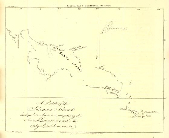
[page] 277
CHAP. XVI.
Discovery of the Salomon Islands, by Alvaro de Mendana.
1567.
AFTER the settlement of the Spaniards in the Philippine Islands, the next voyage of importance to the geography of the Pacific Ocean, of which there appears any published relation, was made by Alvaro de Mendana in 1567. Lopez Garcia de Castro, having become, by a vacancy in the vice-royalty, president and governor of Peru, fitted out vessels for the purpose of discovering lands which were believed to exist in the South Sea. It is doubtful whether or not this belief was merely conjectural. From a passage in Herrera's description of the Indies*, it may be inferred that the name of the Salomon Islands had been applied to some discovery made at a more early period. In the sequel it will be necessary to notice other circumstances which give room for the supposition that voyages of discovery were made about this time by the Spaniards, of which no account has ever publicly appeared.
The expedition which is the subject of the present chapter, was commanded by Alvaro de Mendana, a relation of the president. With him went as chief pilot, Hernan Gallego, who had sailed in the same capacity with Ladrilleros. The fullest account that is extant of this voyage, is in lib. v. of a work entitled Hechos de Don Garcia Hurtado de Mendoça, 4me Marques de Cañete, written by Dr. Christoval Suarez de Figueroa, printed at Madrid, 1613. This work is dedicated to the Duke of Lerma, and the approbation is signed by Antonio de Herrera. The account given by Figueroa, of Mendana's voyage, though defective in many parts, carries in itself suffi-
* Cap. 27.
[page] 278
1567.
cient evidence that it was drawn up from the journals of the discoverers.
What ships or force Mendana had with him, Figueroa has not otherwise specified than by, making mention of two ships in the course of his narrative. This being the only account which has been met with of the voyage, it has appeared necessary to give from it a translation nearly literal, and particularly in the statement of the geographical facts, some of which are ambiguously expressed. In the narrative of Figueroa, there are frequent and abrupt transitions to new subjects; but his expressions are brief and to the purpose.
Ilse de JESUS.
BAXOS DE LA LARIA.
They departed from Callao (the port of Lima) January the 10th, 1567*. After sailing 1450 leagues, a small island was discovered in latitude 6° 45′ South, which they named Isla de Jesus, of which nothing farther is said, than that it was inhabited by people who in colour resembled Mulattos. The weather began here to be unsteady, with thunder and lightning. At 160 leagues distance from the I. de Jesus, they discovered reefs, in the midst of which were small islands. They were seen to extend 15 leagues, and lay in a direction North East and South West. The middle part was in latitude 6° 15′ South. They were named Baxos de la Candelaria (the Shoals of Candlemas). From the island De Jesus, to these, the ships were 17 days in navigating.
SANTA YSABEL.
They had sight of other land, (whether seen from Candelaria, or after leaving those shoals, is not specified,) which they went to examine, and found a port where the ships anchored, to which was given the name of Sta Ysabel de la Estrella (Sta Ysabel of the Star.) This land was of large extent. It was inhabited by people who were of the complexion of. Mulattos, and had
* In Figueroa erroneously printed 1568. Herrera dates the departure of Mendana in 1567; and Figueroa himself makes the return to Peru in January 1568.
[page] 279
1567.
A brigantine built.
curly hair. They wore scarcely any covering; and they worshipped serpents, toads, and similar creatures. Their principal diet was cocoa-nuts and roots, particularly a root they called venaus. There appeared among them a scarcity of animal food; and it was believed that they eat human flesh; for the Chief sent to the General a present of a quarter of a boy with the hand and arm. The General ordered this gift to be buried in the presence of those who brought it, which appeared to give them much offence. These people had frequent wars with their neighbours, and made captives. The Spaniards performed mass on shore; and, finding good materials here, they built a brigantine, in which the General sent the Maestre de Campo, Pedro de Ortega, with 18 soldiers, 12 mariners, and the pilot Hernan Gallego, to make farther discoveries.
She is sent on discovery.
Island MALAITA.
The brigantine sailed to the South East, the coast of Sta Ysabel running in that direction, and being on their right hand. Six leagues from the port, they found two small islands, with tall palm trees, in latitude 8°; and afterwards, in the same direction, many others. They likewise saw a great bay with eight small islands, all inhabited by people, whose weapons were clubs, bows, and arrows. To the East of this bay, at 14 leagues distance, they saw a large island, which was called by the Indians Malaita. In the midway lay two small islands, in latitude eight degrees. It being Palm Sunday, one of the islands was named I. de Ramos.
As they proceeded along the coast of Sta Ysabel, they came to a port and a cape in nine degrees latitude, about 14 leagues distant from the bay they had passed; they named the cape, Prieto, (i.e. the Black Cape). To the South East from this
* In Figueroa, it is South West (Edit. 16*13): but the subsequent account shows that it ought to have been South East, and it has been so rendered by M. Fleurieu, in his Account of Discoveries to the South East of New Guinea.
[page] 280
1567. LAGALERA
BUENAVISTA.
FLORIDA. SANDIMAS. SAN GERMAN, GUADALUPE. SESARGA.
cape, about nine leagues distant, they found several islands. They went to the first, which was five leagues in circuit, and LAGALERA surrounded with reefs. They called it La Galera. A league beyond La Galera, and South East nine leagues from cape Prieto, is another island, of 12 leagues extent, which appeared fertile, and was well peopled, the natives living in regular villages or towns. They named this island Buena Vista: its latitude is 9 1/2 degrees. In its neighbourhood were seen many other inhabited islands, and five that lay in a chain East and West. They landed at the first. The natives dyed their hair red: they were much afraid of fire arms: when they collected together, or gave alarms, it was by the sound of conch shells and drums. They eat human flesh. This island is 25 leagues in circuit, its latitude 9° 30′. The Spaniards named it Florida. The names given to the three others, were San Dimas, San German, and Guadalupe. To the South of the five islands, there lay another, which was named Sesarga: [probably on account of its shape, Sesga, in the Spanish language, signifying a slope or declivity]. It is about 8 leagues in circuit, in latitude 9 3/4°; and lies South East from Buenavista, 5 leagues distant. It is high, round, and well inhabited. This island produced yams and bread-fruit (panays) in great plenty, and some hogs were seen. In the middle of the island was a volcano, which continually emitted smoke.
ISLAND GUADALCANAR.
Beyond this, was seen an island of. great extent, in which was a deep and broad river, from whence many natives, men, women, and children, came in canoes to look at the Spaniards. The Maestre de Campo went on shore at a village, where he found baskets with green ginger and other good roots; and likewise some hogs. This island the Spaniards named Guadalcanar, and the river, De Ortega. From this place the brigan-
* By which it appears that Buenavista was one of the five.
[page] 281
1567.
tine turned back to seek the port where the ships had been left.
1567. The brigantine sails round Sta YSABel.
They were [then] ordered to sail round the island Sta Ysabel. They passed close to Cape Prieto, and from thence towards the West. Seven leagues from the cape to the West South West, [the account in Figueroa adds likewise, 'at the distance of five leagues,' but from what place has been omitted,] is an island, to which they gave the name of San Jorge. The channel formed by this island with Sta Ysabel, is six leagues broad at the South East entrance, and but one league broad at the Western. Here was found a port, with depth of water from 8 to 12 fathoms, clear, and sufficiently capacious to contain 1000 vessels: the entrance was to the South East, and the passage out, to the North West, at which part there was a town consisting of more than 300 houses. Pearls were seen in the island San Jorge, which the Indians held in small estimation, and gave many to redeem a canoe which had been taken from them.
The brigantine pursued her course along the coast of Sta Ysabel; and having gone 40 leagues, came to extensive reefs, among which were many canoes with Indians fishing. The canoes all advanced, and the Indians shot their arrows at the brigantine, and then retreated. Among these reefs, there are many small islands, some inhabited and others not. And near the point or end of Santa Ysabel, which runs to 7 1/2 degrees [latitude], there were many inhabited islands. The length of this island was reckoned 95 leagues, the breadth 20, and the circuit more than 200 leagues †.
* The wind being at the time from the South East, must have occasioned this port to be thus described; for without some peculiar circumstance of wind or current, every entrance into a port must be an outlet, and vice Versa.
† This measure is much too great for the island Santa Ysabel. It may be suspected that the distances were designed for the whole of the islands sailed round by the brigantine: and so applied, they would be tolerably correct.
O o
[page] 282
1567.
Bats were seen, which, between the tips of the wings when extended, measured five feet.
Having coasted the whole length of the South West side of the island, and arrived at the North West extremity, they found the winds blowing regularly from the East and South East; and they had to navigate in that direction, to arrive at the port De Estrella, where the ships lay. They could not at first make any progress against the winds. The M. de Campo therefore sent forward a canoe with nine soldiers, one mariner, and a native whom he had made his friend, to inform the General where the brigantine was, and the cause of her detention. The canoe proceeded along the coast, till falling in among reefs, she was beaten to pieces. The men got safe to land. Their powder being damaged by the water, they travelled back, by the sea side, towards the brigantine, in constant apprehension of being attacked by the Indians. Fortunately for them, the brigantine advanced along the coast, and took them on board; and afterwards she made her passage good to the ships.
The ships sail to GUADALCANAR.
The ships companies were sickly, and some of the people had died: the General therefore left the port, (De la Estrella,) out of which the ships sailed by an opening between reefs, which are at its entrance. With East winds, accompanied by squalls, they sailed to the island Guadalcanar, where they anchored opposite to a beach. They searched for another port, and found one near to a river; the river they named Gallego, and the port De la Cruz. The next day, they took possession of the land for the King of Spain, and erected a cross on a little hill, in doing which they were attacked by the Indians with bows and arrows. Two of the Indians were killed by the Spanish fire-arms, and the rest fled. Afterwards the General sent Don Fernando Enriquez, with the chief pilot, and 30 soldiers, to examine the country. Whilst they were, in search of a river, the natives attacked them in such numbers, that they were obliged to give
[page] 283
1567. GUADALCANAR.
The brigantine again sent on discovery.
Returns.
up their pursuit, and attend solely to their defence. The mariners reported, that in this river there was a quantity of gold. As the party returned, they bartered with the natives for two hens and a cock, which being the first fowls that had been seen among the islands, was a circumstance that gave great satisfaction to the General. The Spaniards continued to make daily discoveries of new lands, and to gain knowledge respecting the country. Don Fernando, and the chief pilot, were sent in the brigantine to the East South East, and having sailed two leagues in that direction, they came to the river Ortega, and found the coast full of villages. They proceeded, stopping occasionally at 'different islands and rivers, too many to particularise.' At some places they found the natives hostile, and at others they experienced friendly treatment. At length they returned to the ships.
During the time that the brigantine was absent on this service, the Indians had attacked a boat that was sent to take in water, and killed the steward and nine other Spaniards. The chief of the district where the ships lay, had, at one time, shown friendship for the General; but he was afterwards disgusted on account of the General having seized a boy, one of the natives, whose release the chief had demanded and had been refused. Captain Pedro Sarmiento, was sent, with all his men, to take revenge for the attack which had been made on the boat. They landed, and killed twenty of the Indians, and burnt many of their habitations; which having done, they returned on board. A second descent was made, and more houses were destroyed.
June. 1567.
At the island SAN CHRISTOVAL.
June 13th, the ships sailed from port De la Cruz, and beat up to windward, by the coast of Guadalcanar, in a track which the brigantine had been before. From hence they went to another island, to which was given the name of San Christoval, where a port was found, and the ships anchored. At this place
O o 2
[page] 284
1567.
the General landed; but the natives were not pleased with the visit, and made signs to the Spaniards that they should return to their ships; which desire of theirs not being attended to, they showed their displeasure by various gestures and actions. They scattered the sand about with their feet and hands, and running into the sea, threw the water up into the air. Seeing the disposition of the natives, the General ordered the trumpet to be sounded for a retreat; but Pedro Sarmiento landed with his people and joined the General. The Indians advanced towards them in order for battle, each man being armed with two or three darts, and with clubs, bows, and arrows. The General not being able to keep them at a distance by signs or speech, to avoid being embarrassed by their too near approach, ordered some muskets to be fired, by which one Indian was killed, and others wounded; the rest dispersed and fled. The Spaniards entered one of their towns, and found a quanity of cocoa-nuts and almonds sufficient to have loaded a ship, and the rest of the day was employed in transporting these provisions on board, the Indians not daring to interrupt them. At night the Spaniards re-imbarked.
Sta CATALINA. Sta ANA.
The island San Christoval is narrow and mountainous. The port where the ship anchored is in 11 degrees latitude. The brigantine was sent to make farther discoveries. She found two islands three leagues apart from each other: one was named Sta Catalina, the other Sta Ana. Sta Ana is low and round, with a rising in the middle, which has the appearance of a castle. It is well peopled and fertile: on it were hogs and fowls, and there was a good port on the East side. The discoverers landed here, and were attacked by the natives, who were painted with different colours. They carried boughs on their heads, and each wore a band round his body. Three of the Spaniards were wounded by them. A dart was thrown at the Spanish commanding officer with so much force, that it pierced through both his
9
[page] 285
1567.
target and arm. Two of the Indians being killed by the musquetry, the rest fled. The brigantine coasted along the island San Christoval, and returned to the ships.
Mendana sails for NEWSPALN
According to the report of the chief pilot, no more land was discovered in this quarter; but to the Westward he was of opinion there would be found land of large extent. The General held a consultation with the officers and pilots, in which it was resolved to repair the ships and return to Peru by the Northern navigation, without employing more time in making discoveries, as their provisions and stores were nearly expended. The ships, agreeable to this determination, were repaired; and they sailed from the port of the island San Christoval. They were seven days occupied in getting to windward of that island; after which, with winds from the South East quarter, they sailed to the North East and North East by East. They had afterwards at times the Wind from the North East quarter.
Island SAN FRANCISCO
Between the parallels of 4° and 2° South, they passed some matting of palm leaves, and burnt wood, floating on the water; which it was conjectured had drifted out of the rivers of New Guinea, and that country was supposed to be but a small distance to the West. Near the equinoctial, they had light winds, and were 11 days in advancing 25 leagues. In 5° North they had a heavy fall of rain, and filled their water casks. After this, they had the wind steady from the Eastward. 'They saw land and went to it.' [No latitude or other mark of situation is mentioned]. It was inhabited; but the natives kept at a distance. The Spaniards found a tool made of an iron nail, a fowl, and some pieces of cord. They could meet with no water; but palm trees were seen cut in such a manner as to collect the juice for a beverage. They saw farther on, a low, round sandy island, surrounded with reefs, on which were a few bushes, and sea birds innumerable. It was two leagues in circuit, and its latitude 19° 20′ North. They named it San Francisco.
[page] 286
1567.
Returns to LIMA.
They ran to the North of 30° latitude, and (in October) met hard gales of wind in which the Capitana was in danger of foundering, and obliged to cut away her mainmast; and they lost sight of the Almiranta (the ship of the officer next to the commander in chief). The Capitana afterwards made the land of California near the Isle de Cedros, and anchored in a bay on that coast. At length, on January the 22d, 1568, they anchored in the port of Santiago; and three days after, they had the satisfaction of seeing the Almiranta arrive, but without her. mainmast, and in as distressed a state as the General's ship. They sailed from Santiago, March the 2d, and returned to Lima.
The description of the lands seen in this voyage, do not appear to have immediately excited any uncommon degree of interest or expectation in the minds of the Spaniards in Peru. The name of the Salomon Islands was however given to the whole of the large group of islands discovered by Mendana, from his making Sta Ysabel to his sailing from San Cliristoval; but was probably not conferred on them till after the conclusion of the voyage, as it does not occur in the account of Figueroa. In 1572, Ave find that the Salomon Islands were spoken of, as appears from a short description of New Spain, written that year by Henry Hawks, an Englishman, who had visited that country, and which Hakluyt has inserted in his Collection of Voyages. Hawks gives the following short relation:
'Four years past, to wit, 1568, a ship made out of Peru to seek the Salomon Islands, and they came somewhat to the South of the equinoctial, and found an island with many black people, in such number that the Spaniards durst not go on land among them. And because they had been long upon the voyage, their people were very weak, and so went not on
* Hakluyt, Vol III. p. 467.
[page] 287
land to know what commodity was upon it. And for want of victuals, they arrived in Nova Hispania, in a port called De Navidad, and thence returned back again unto Peru, where they were evil entreated, because they had not known more of the said island.'
Whether this relation had its origin in reports which circulated in Mexico, concerning the voyage of Mendana, or that another voyage of discovery was undertaken from Peru immediately after his return, appears doubtful. It is however well established that the islands of Mendana were not revisited by Europeans till two centuries after their discovery, though the appellation of the Salomon Islands encouraged romantic ideas concerning the riches to be found there. Lopez Vaz says, in the conclusion of his discourse, that 'the discoverer of these islands, named them the Isles of Salomon, to the end that the Spaniards, supposing them to be those isles from whence Solomon fetched gold to adorn the temple at Jerusalem, might be the more desirous to go and inhabit the same*.'
Geographical Remarks.
The lands discovered by Mendana in this voyage are:
The Island de Jesus,
The Baxos de la Candelaria,
The Salomon Islands,
And two Islands in North latitude.
It is doubtful whether the mention of some distance has not been omitted between Candelaria and Sta Ysabel. The distance from Callao to Sta Ysabel is 2100 Spanish leagues. By the Spanish reckoning in this voyage, supposing no part left out
* Hakluyt, Vol. III. p. 802.
[page] 288
in the account, the distance was estimated at only 1610 leagues; but there are so many instances of errors, equal in magnitude, and of a similar nature (i. e. the distances diminished), among the reckonings of the early navigators in the Pacific Ocean, that no inference of omission can be fairly made in the present case. Figueroa has not given dates, which might have assisted in supplying the deficiency of other information. Herrera, in his Description de las Ind. Occid. says ' in 7° latitude, and to the North of Sta Ysabel, are the shoals of Candelaria.' Herrera's information respecting the Salomon Islands was general, and not very correct. It however may be deemed, with the addition of the other circumstances, sufficient for admitting, that if Sta Ysabel was not discovered from the Baxos de la Candelaria, it was seen very soon after quitting those shoals.
BAXOS DELA CANDELARIA.
The discoveries of the last forty years have verified the discoveries of Mendana, though the knowledge obtained of the geography of the Salomon Islands is not move than sufficient to explain their general position. Very few of the points marked in the original account have been recognized and identified. M. Fleurieu believes, that a shoal which the Spanish frigate La Princesa fell in with, in 1781, and named El Roncador, is the Baxos de la Candelaria of Mendana. The place and circumstances support this conjecture; and M. Fleurieu has calculated the situation from such information as the journal of the Princesa's voyage furnished; by which he makes the South West part of the shoal to be in latitude 6° 45′ South, and longitude [from Paris 157° 45′ East] 160° 05′ East from the meridian of the Observatory at Greenwich.
Island DE JESUS.
Taking this longitude for the Baxos de la Candelaria, (the West part), the island De Jesus, to preserve the proportion of the distances given in the narrative (1450 leagues
* Cap. 27.
[page] 289
from Callao, and 160 leagues from La Candelaria) must be placed in 172° 30′ East longitude from Greenwich.
The voyage of Mendana afforded opportunities for making a good chart of the Salomon Islands, but good charts were not among the common productions of that time, and it might be asserted, without presumption, that a good chart of the Salomon Islands has not yet existed. The whole which is at present known of them, is by no means equal to what appears to have been known by the first discoverers. From their time till after the middle of the last century, it may in strictness of truth be said, that the Salomon Islands were lost to the knowledge of Europeans. Conjectures respecting their situation, varied more than one third of the distance across the Pacific Ocean; and it has been thought necessary to advance arguments to prove that the original accounts were not fictitious. The voyage of M. Surville, in 1769, must be said to have first put an end to this uncertainty, and to have determined their situation; for the islands of the North West extremity, seen by M. Bougainville in the year preceding, were not marked by such peculiar circumstances as could establish any proof of their forming a part of the Salomon Islands.
M. Fleurieu, with much study and labour, put together the parts of this archipelago, which were seen at different times; the North West part by M. Bougainville, in 1768; the North East part by M. Surville, in 1769; and the South West side, as delineated by Lieutenant Shortland of the British Navy, in 1788. Since that time the Salomon Islands have been seen in different parts, by both English and French navigators. If the whole of the materials obtained by them can be collected, the geography of those islands will be much advanced, but will still be far from perfect. These materials could not be procured for the present purpose; but to render more easily intelligible both the narrative and a few remarks of comparison between
P p
[page] 290
the first accounts and the modern discoveries, a sketch has been annexed, for the basis of which, M. Fleurieu's reduced chart has been followed. The variations made, are chiefly in the South East part, from the track of M. d'Entrecasteaux, as described in Labilladiere's publication. Taking that and the latitude for guides, the Capes Philip and Sidney of Shortland, have been joined to the Eastern land or Cape Oriental of Surville, which, by the track of M. d'Entrecasteaux, appears to be more to the North than it was formerly laid down.
SANCHRISTOVAL.
This position of the shores, and the views of the Eastern land which were taken from M. Surville's ship, accord with the old accounts, which describe San Christoval to be narrow and mountainous land.
Sta CATALINA, and Sta ANA.
The Isles De la Delivrance answer to the Sta Catalina and Sta Ana of Mendana, beyond which 'in that quarter no more land was discovered.'
SESARGA.
Placing the Cape Sidney, of Mr. Shortland, so much to the Eastward, renders it necessary to give extension to the whole of his survey, by which his Mount Lammas is carried more to the East, and additional reason given for the conjecture that it is the Sesarga of Mendana.
Cape PRIETO.
The Cape Prieto may be looked for to the North West from the Mountain. According to the first accounts, that cape is so much surrounded by islands, (by Malaita and others, to the North and East, by Buena-vista, San Jorge, &c. to the South East and South West,) that probably it would not be visible either to M. Surville, or to Mr. Shortland, who both, though on different sides, sailed clear without the archipelago, and, in the greater part of their tracks, were too far distant from the land to distinguish and ascertain the capes and openings.
The port De La Estrella, and the island Malaita, are marked from M. Fleurieu's sytematic chart of the Salomon Islands.
[page] 291
Sta YSABEL.
Since their voyages, it has been proved, by different passages which have been navigated, that the island Sta Ysabel, at which Mendana first anchored, cannot have the extent mentioned in the account of Figueroa; and it must be supposed either that the brigantine passed some openings without noticing them, or that the distances, 95 leagues in length, and 200 in circuit, were intended to include all the islands which she had at that time circumnavigated. One of the late penetrations was made to the East of Cape Nepean, and passing through, came out near the harbour which M. Surville has named Port Praslin, giving 7° 18′ South, for the latitude of the North West part of Sta Ysabel.
The foregoing observations do not entirely agree with the opinions formerly held by M. Fleurieu. The subjects of difference, however, are points merely of conjecture; and the variations, such as the additional information obtained since those opinions were formed, might naturally produce. M. Fleurieu's reputation for geographical knowledge and penetration, are established upon too good a foundation to render any explanation of this nature necessary upon his account.
The islands seen to the North of the equator by Mendana, in his return to New Spain, are not entitled to any notice in the charts, from the account given in the relation of Figueroa. A small island surrounded with rocks, with the name of San Francisco, is placed in the chart of the track of the Galeon, in Commodore Anson's voyage, in 191/2 ° North latitude, and 84° of longitude East from the Strait of San Bernardino; but, this is not to be supposed the San Francisco of Mendana, as his track in crossing the trade wind from the Salomon Islands, could not have been so far to the East in that parallel.
P p 2
[page] 292
CHAP. XVII.
Progress of the Spaniards in the Philippine Islands. The Islands San Felix and San Ambor discovered. Enterprise of John Oxnam, an Englishman, in the South Sea.
1571.
City of MANILLA built.
IN the Philippine Islands, the Spaniards did not remain contented with the possession of the single Island of Zebu. They extended their 'pacification'* to other islands, and, in 1571, established themselves in Luconia, under the direction of Miguel Lopez de Legaspi, who, that year, founded the city of Manilla, which has since been, and is at present, the capital of the Spanish settlements in the Philippine Islands.
Islands SAN FELIX and SAN AMBOR discovered. 1574.
In 1574, the pilot Juan Fernandez, discovered two more islands in the neighbourhood of the American Continent, which were named San Felix and San Ambor. They are described by the Spanish accounts to be small, uninhabited, and uninhabitable, being without fresh water; and that they were the resort of birds, sea calves, and fish. Their latitude 25° 20′ South, and their distance to the West from Copiapo, 154 leagues†.
* Grijalva, Edad 3. cap. 20. fol. 137, col. 4. It ought to be remarked, but not as an apology for the Spaniards, though it is unfortunately true, that bad actions mutually lend countenance to each other, that the conduct of other European nations, in their treatment of the Indians, was upon a model very similar. The patent of HENKY VII. of England, to the Cabols, grants licence (plenam ac libcram authorilatcm) to him and his three sons, to inake discoveries of countries inhabited by Gentiles and Infidels: 'and the towns, cities, castles, islands, &c. which they are able to subdue, occupy, and possess, to subdue, occupy, and possess them accordingly, (quæ subjugari, occupari, possideri possint, subjugare, occupare, &c.) as our lieutenants and governors.' Hakluyt's Collection of Foyages, Navigations, &c. Vol. III. p. 4.
† Viage al Estrecho de Magallanes, por el Cap Pedro Sarmiento de Gamboa en los annos 1579, 1580, p. 50. Captain Colnet, who visited them, in 1793, has laid down. their positions;
San Felix, in 26° 14′ South, and longitude 79° 24′ West from Greenwich.
San Ambor—26° 17′ South, 79° 10′
By the Spanish charts they are placed three miles more to the South, and 0° 42′ of longitude more to the West, than by Captain Colnet.
[page] 293
The English at this time first began to project enterprises in the South Sea. England and Spain were not in a state of open war; but the circumstances and events of the reigns of PHILIP the IId, and of Queen ELIZABETH, were such as did not fail to produce a strong degree of animosity between the two nations; which neither would be at the pains to conceal. Acts of aggression were committed by individuals of both, and connived at, sometimes encouraged, by the Sovereigns. During a great part of Queen ELIZABETH'S reign, the two countries may be said to have been in a slate of open (though not declared) enmity, and of private warfare.
With these dispositions, a number of English adventurers entered into schemes for enriching themselves at the expense of the Spanish settlements in America; in revenge, it is said, for injuries done either to themselves, or to some of their countrymen, by the Spaniards in that part of the world. John Oxnam, or Oxenham, of Plymouth, was the first Englishman who extended these schemes to cruising against the Spaniards in the South Sea. He had accompanied Captain (afterwards Sir Francis) Drake, in 1572–3, on an expedition to the West Indies, in which that commander left his ship on the North side of Darien, and, being joined by the Indians who inhabited that part of the country, marched across the isthmus with the intention of intercepting the Spanish treasure that was expected to have been sent upon mules from Panama to Nombre de Dios. The drunkenness of one of the English seamen prevented this attempt from succeeding*.
In the account of Captain Drake's journey across the isthmus, there is the following passage: 'it gave a special encouragement unto us all, that we understood there was a great tree about
* Sir Francis Drake Revived, p. 58.
[page] 294
the mid way, from whence we might at once discern the North Sea from whence we came, and the South Sea whither we were going.
The fourth day following, [this was the eighth day of their journey,] we came to the height of the desired hill, (lying East and West, like a ridge between the two seas,) about ten of the clock; where the chiefest of the Symerons* took our Captain by the hand, and prayed him to follow him. Here was that goodly and great high tree, in which they had cut and made divers steps to ascend near to the top, where they had made a convenient bower, wherein ten or twelve men might easily sit; and from thence we might see the Atlantic Ocean we came from, and the South Atlantic so much desired. South and North of this tree, they had felled certain trees, that the prospect might be the clearer.
After our Captain had ascended to this bower, with the chief Symeron, and having, as it pleased God at this time by reason of the breeze, a very fair day, had seen that sea of which he had heard such golden reports; he besought Almighty God of his goodness, to give him life and leave to sail once in an English ship in that sea. And then calling up all the rest of our men, acquainted John Oxnam especially with this his petition and purpose, if it would please God to grant him that happiness: who, understanding it, presently protested, that unless our Captain did beat him from his company, he would follow him by God's grace†.'
* The name by which the independent Indians who then inhabited the Isthmus of Darien were called. They were people who had fled from the dominion of the Spaniards; and living on that account in a state of continual warfare with their former masters, they willingly joined themselves with the English. The hill up which Drake was conducted, might probably be the same from whence Nunnez de Balboa first saw the South Sea.
† Sir Francis Drake Revived, p. 54. Quarto Edit. 1653. London.
6
[page] 295
To both was granted the desired boon of sailing upon the South Sea; but they went by different routes, at different times, and their enterprises finished with different success.
The following testimony is borne to the ability and fidelity with which Oxnam served under Drake. There was occasion to send a party of men on shore, for a purpose which the people would not consent that their Captain (Drake) should undertake. The relation says, 'John Oxnam and Thomas Sherwell were put in trust for our service, to the great content of the whole company, who conceived greatest hope of them next our Captain, whom by no means they would condescend to suffer to adventure again this time*.'
1575.
Drake's return to England from the voyage just noticed, was in August 1573. In 1575, Oxnam was again in the West Indies, having under his command a ship of 120 tons burthen, and 70 men. The history here given of his adventure, is extracted from An Account of the West Indies, and the South Sea, written by Lopez Vaz, a Portuguese, which, with its author, fell into the hands of the English, in Rio de la Plata, in 1586, Portugal at that time being a part of the Spanish monarchy, and at war with England.. An abridged translation of the work of Lopez Vaz, is in Hakluyt, Vol. III. p. 778.
Oxnam went among the Symerons,. (the Indians before described,) who were equally well disposed to the English as on the former occasion. When he was informed that a new regulation had been made by the Spaniards, and that the treasure was now always conducted by a strong guard of soldiers, he determined on an enterprise equally bold and extraordinary.
Oxnam crosses the Isthmus of DARIEN.
He landed his men in the same place where Captain Drake had before landed, and laying his ship ashore, covered her with
* Sir Francis Drake Revived, p. 81.
[page] 296
1575.
Builds a vessel, and launches into the SOUTH SEA.
Returns to the Isthmus.
boughs of trees, and buried all his guns in the ground, except two small pieces of ordnance, which he took with him, besides muskets, and a sufficient store of provisions and necessaries. Thus furnished, without leaving one man in the ship, he departed for the other sea, accompanied by a number of the Indians. When they had marched 12 leagues, they arrived at a river which ran into the South Sea. In a wood by the side of this river, Oxnam cut timber, and built, a pinnace, which was 45 feet long by the keel. When the pinnace was finished, he embarked with his people, and fell down the river into the South Sea*, taking six Indians with him for guides. They sailed to the Pearl Islands, and remained near them ten days, at the end of which time they captured a small bark from Quito in Peru, in which were 60,000 pesos of gold†, and a quantity of wine and bread. Shortly after, they made prize of a vessel from Lima, with 100,000 pesos of silver in bars. These riches were all taken into the pinnace, and they went to a small town on one of the Pearl Islands, inhabited by Indians, from whom it was hoped pearls would be obtained; but the Indians had not many. From the Pearl Islands, they went towards the main land, and after dismissing the two prizes, the pinnace re-entered the river from which she had sailed. Some of the Indians at the Pearl Islands, as soon as the Englishmen had departed, hastened in their canoes to Panama, to give notice of what had passed.
* We read of an inhabitant of Britain, who embarked on the South Sea, before this expedition of Oxnam; but it was only as a passenger, and in a Spanish vessel. This was John Chilton in the year 1572, who sailed from Panama to Peru.
It is probable that other Britons were on the South Sea before Chilton, as it appears that a North Briton, Thomas Blake, settled in the city of Mexico, so early as the year 1536. Hakluyt, Vol. III. p. 450. and 458.
† The peso of gold was 16 Spanish rials, nearly equal to eight shillings English: the peso of silver was half of that value.
[page] 297
1575. Is pursued by the Spaniards.
The Governor of that place, within two days after receiving the intelligence, sent four barks, in search of the English, with 100 soldiers, and a number of Indians, under the command of Juan. de Ortega. Ortega went first to the Pearl Islands, and was there informed what course the Englishmen had taken; and continuing his pursuit, he met the vessels that had been captured and dismissed. By them he was directed to the river. When he came to the entrance, he was at a loss which way to take, as the river fell into the sea by three different mouths. Whilst he was deliberating, a quantity of feathers of fowls were observed floating out of one of the lesser branches; and that way Ortega entered. The fourth day, according to the account, of his advancing up the river, the pinnace of the Englishmen was descried lying upon the sand, with only six men near her, one of whom was killed by the Spaniards, and the others fled. The pinnace was searched; but there was nothing in her except provisions. Leaving twenty of his people to take care of the barks, Juan de Ortega landed with 80 men, armed with musquetry. When they had marched half a league from the river, they found a place that was covered with boughs of trees, where the Englishmen had hid all their booty, which the Spaniards dug up, and with it returned to their barks, well satisfied with their success, and not intending to trouble themselves farther about the English. But Oxnam, with all his men, and 200 Symerons, eager to recover the treasure, followed the Spaniards to the river's side, and attacked them with more impetuosity than good management. Ortega disposed his men advantageously among the bushes; and the English were repulsed with the loss of eleven men killed, and seven taken prisoners; whilst, on the part of the Spaniards, only two were killed, and a few wounded. The prisoners were questioned,
Q q
[page] 298
1575.
how it happened that they had not departed with their treasure, having been fifteen days unmolested. They answered, that their Captain had commanded his men to carry all the gold and silver to the place where the ship was, and had promised them a share; but the seamen demanded an immediate division; upon which the Captain, being offended at their distrust, would not suffer them to carry it; but said he would get Indians to undertake the business. The delay occasioned by these disagreements, gave time for the Spaniards to overtake them. Oxnam received the first notice of their approach by the men who fled from the pinnace. He then came to an agreement with his people, and got the Indians to join with him; but in the attack, having lost several of his best men, he purposed to return to his ship.
The Spanish Captain, with his prisoners and the treasure, returned to Panama, the Governor of which place immediately dispatched messengers to Nombre de Dios, with intelligence where the English ship lay concealed; in consequence of which, before Oxnam arrived at the place, his ship, ordnance, and stores, were taken.
In this desitute condition the Englishmen lived some time among the Indians; and had begun to build canoes on the North side of the Isthmus, as the means by which they might escape from their present situation; but having lost all their tools, their work was advancing very slowly, when 150 Spaniards, sent by order of the Viceroy of Peru, came upon them, and put an end to their occupation. Fifteen, who were sick, were at that time taken prisoners; and, in the end, they all fell into the hands of the Spaniards, and were carried to Panama. Oxnam was questioned whether he had the Queen's commission, or a license from any other Prince or State? To which he replied, that he had no commission; But that
[page] 299
1575.
he acted upon his own authority, and at his own risk. Upon this answer, Oxnam and his men were all condemned to death; and the whole, except five boys, were executed. Thus unfortunately did the first exploit of the English in the South Sea terminate. Of Oxnam, their leader, it has been remarked, that if the same spirit of enterprise and resolution had been exerted by him in a legal cause, he would have been entitled to lasting praise.
Q q 2
[page] 300
CHAP. XVIII.
Reports concerning the Discovery of a Southern Continent.
1576.
ABOUT this period, a discovery is attributed to Juan Fernandez of greater importance than any of those formerly made by him; but the accounts that appear concerning it, are brief and obscure. The recent enterprises of other Europeans in the South Sea, must have rendered the Spaniards more than usually circumspect in preventing all knowledge concerning their possessions and discoveries in that part of the world from being made public: and it is supposed that the apprehension of more serious attempts being meditated, was the reason that the farther prosecution of the discovery and establishment of the Salomon Islands was for the present suspended.
Concerning the discovery just alluded to of Juan Fernandez, there appear, in a memorial written by Doctor Juan Luis Arias, the following short notices, which exhibit a curious mixture of the probable and the fabulous. No date is affixed to the memorial: but it was written after the English had settled in the Bermudas (which was in 1609), and that event is mentioned as an incitement to the Spanish monarch to form establishments at the islands discovered in the Pacific Ocean, lest the English or Dutch should take possession of them, and introduce among the natives the venom of their heresy.
Arias says, 'The pilot Juan Fernandez sailed from the coast of Chili, a little more or less than 40 degrees, in a small ship, with certain of his companions; and navigating upon courses between the West and South West, arrived in a month's time at a coast, which, as far as they could judge, appeared to be continent (tierra firme), the land fertile and pleasant, in-
*
[page] 301
habited by white people, well made, of our own stature, dressed with very good woven cloth (muy buenas telas), and so peaceable and kind, that by every way in which they could make themselves understood, they offered the Spaniards entertainment of the fruits and riches of their country, which appeared to be in all parts good and fruitful. But having gone so lightly equipped, they were fully content for this time, with having discovered the coast of this great continent (gran tierra firme) so much desired; and they sailed to Chili with the intention of again returning to the same land, better provided; and determining, till that could be done, to keep the discovery secret. But the matter was delayed from day to day, till Juan Fernandez died; and, with his death, this important business fell into oblivion. But it is to be noticed, that many have reported this discovery of Juan Fernandez in the following manner, affirming that they heard it from himself. That is to say, that steering to the West from Lima, being bound to Chili, and having departed from the coast to a certain longitude, which in proper season would be declared, and afterwards steering nearly on a South course, he discovered the aforesaid coast of the Southern continent, in a latitude which likewise, when convenient, would be made known; from whence he made his voyage to Chili'.
[It is to be remarked that the most material point in which these accounts differ, is respecting the outset, which in one is stated to be from the coast of Chili, and in the other, from Lima. Both agree that from the discovered land, Juan Fernandez sailed to Chili; and, except in the first particular, the two accounts serve to illustrate each other]. Juan Luis Arias continues;
'Other relations, well worthy belief, place the discovery as at first stated; but whether it be in this or in the other manner, or that there were two different discoveries, it is a thing certain that the coast of the Southern continent was discovered; for this has been testified by persons of great credit and authority,
[page] 302
to whom the said Juan Fernandez communicated the account, with the above-mentioned descriptions and circumstances of the coast and of the inhabitants. And one of these witnesses who has affirmed this to your Majesty, and who heard it from the said pilot, and saw the description which he drew of the coast, was the Maesse de Campo, Cortes;, a man of well known credit, and who had been employed in Chili near 60 years.—On the coast of this land were seen the mouths of very large rivers.'
Some particulars in the foregoing accounts, oppose their being wholly rejected. The mode of navigating described in the relation, is exactly conformable to what would naturally be practised on such an occasion, and with such views. When Juan Fernandez first made the experiment of a new route from Lima to Chili, it may be supposed he did not go farther from the coast than was necessary for getting to the Southward. Increasing confidence in the new navigation, with the hope of making discoveries, appear to have afterwards encouraged him to venture to greater distances. In such cases, he would of course sail as far as he intended to go Westward, within the limit of the trade wind, and afterwards steer to the South to put himself in the way of variable winds.
The only land at present known, that in any respect answers to the description of the Tierre Firme of Juan Fernandez, is New Zealand; but the distance from the American continent, (above 100 degrees of longitude,) though it does not exceed the powers of a good vessel with favourable winds, is full great for a month's sailing; yet it is not sufficient to be conclusive against the possibility of that country having been seen by Juan Fernandez.
It is necessary to remark that Juan Luis Arias, the writer of the memorial from which the report is extracted, was not a man possessed of much geographical knowledge, or who had made enquiry on the subject. In speaking of the discoveries of Mendana, he has confounded dates, names, and situations. He
[page] 303
says, Mendana, besides the Salomon Islands, discovered in the year 1565 the island of San Christoval; its middle, in latitude from seven to eight degrees*. Respecting the Continent of Juan Fernandez, Arias speaks only from reports, which are yet more liable to variation. Nevertheless, the authorities on which he gives them, as well as the circumstances, are such as must be supposed to have some foundation in facts.
Another observation to be made on this subject is, that there remain intermediate spaces, not traversed by any track at present known, capable of comprehending lands much larger than New Zealand.
The, belief of the existence of a Southern continent had gained great strength. A writer of that time, speaking of the land of Guadalcanar,, says, 'yet they know not perfectly what to make of it, but think it may be part of that continent which extends to the Strait of Magalhanes.' The geographers of the same period, likewise, were not less prepossessed with similar ideas, and have represented the Tierra del Fuego, as part of a great continent extending both Eastward and Westward to New Guinea, and round the South Pole, occupying nearly all the space which had not been cut off by the tracks of European navigators; and this ideal continent they have not left destitute of its capes and gulfs.
* Page 16.
[page] [304]
CHAP. XIX.
Voyage of Francis Drake round the World.
1577.
IN 1577, was undertaken the celebrated voyage of Francis Drake into the South Sea. England and Spain still preserved the appearance of peace with each other, and the justice of Drake's undertaking has accordingly been a subject of much question. Arguments, indeed, may more readily be found in its exculpation than in its defence. Drake had himself first received injury from the Spaniards, he being one of those who accompanied Sir John Hawkins to St. Juan de Ulloa, in 1567–8. It is true that he had afterwards made himself some amends by reprisals upon the Spaniards: but he had seen the South Sea, and the golden dreams which that sight presented to his imagination, were a stimulant not easily to be resisted by a man of his enterprising and adventurous spirit.
Drake did not embark on this expedition without encouragement from his superiors. In a relation, entitled, The World Encompassed, it is affirmed that he had a commission from Queen ELIZABETH, his sovereign, and likewise that she delivered to him a sword, with this remarkable speech, "We do account that he which striketh at thee, Drake, striketh at us." That he had a written commission, is not very probable: but there is reason to believe that she favoured and promoted his undertaking. Sir Christopher Hatton, who was vice-chamberlain, and a privy counsellor, introduced him to her Majesty*; and, it is said, he communicated to her the plan of his voyage, and that
* Stowe's Annals, p. 807.
[page] 305
1577.
it received her approbation. By this, and the countenance publicly shown to him afterwards, whatever blame may be imputed to the expedition, the Sovereign shared equally with Drake.
The vessels employed in this expedition were the property of private individuals, his friends, with whose assistance he equipped the following light squadron:
The Pelican, which was the Admiral's ship, burthen 100 tons.
The Elizabeth, of 80 tons, Captain John Winter.
The Marigold, a bark of 30 tons, Captain John Thomas.
The Swan, a fly-boat of 50 tons, Captain John Chester.
The Christopher, a pinnace of 15 tons, Captain Thomas Moone.
These vessels carried 164 men, and were furnished with provisions, arms, and stores for a long voyage, and with the frames of four pinnaces in separate pieces, to be put together as occasion might require. During the out-fit, pains were taken to conceal their destination; and, to prevent suspicions, it was publicly given out that they were bound for Alexandria*.
The smallness of this force for an enterprise of such magnitude, is not so extraordinary as that a navigation, which, on account of its difficulties and dangers, had been many years discontinued, should be undertaken in vessels so diminutive.
Sails from ENGLAND, Dec. 13th.
On the 15th of November, 1577, this fleet sailed from Plymouth with a fair wind; but the next morning, being off the Lizard, the wind came from the South West, and they put into Falmouth, where a violent gale obliged the Pelican and the Marigold to cut away their main-masts, on which account they returned to Plymouth; and, having repaired the damages sustained in the gale, they set sail a second time, December the 13th.
* Relation in Hakluyt's Collection, Vol. III. p. 730.
R r
[page] 306
1577. December.
When they were out of sight of land, the General* first gave occasion to his people to conjecture the route intended, by appointing for the place of rendezvous, in case any vessel should be separated from the fleet, the island Mogadore, on the coast of Barbary.
MOGADORE
December 25th, they made Cape Cantin, on the coast of Barbary, and, on the 27th, they anchored between the island Mogadore and the main land, having first sent a boat before them to sound the depth, which was five fathoms close to the rocks †
The island Mogadore is of moderate height, and about a league in circuit. It is an English mile distant from the main land, the space between forming a good harbour. The best entrance is to the North, for the South channel is dangerous, having but eight feet at low water, and is full of rocks‡.
The island was not inhabited; but the arrival of the ships was soon perceived by the Moors on the main land, many of whom came down to the nearest part of the shore. A white flag was waved to them, and, in return, they made signs that they desired to be taken on board. The General sent a boat to them, and in her, one of his people, who had formerly been a captive in the country, and understood a little of the language. Two Moors, who appeared to be above the common rank, returned with the boat to the Admiral, one Englishman being left on shore as a pledge for their safety. They were well entertained and feasted by the General, who made them presents of some linen, shoes,
* In the early relations of this voyage, the commander in chief is constantly called the General, or the Captain General; and his ship is called the Admiral: in which particulars, the custom of the English and Spanish marine was the same.
† Voyage of Mr. John Winter, by Edw. Cliffe, Mariner. Hakluyt, Vol. III. p. 748.
‡ Ibid.
[page] 307
1577. December. MOGADORE
and a javelin. They promised that the next day they would bring merchandise of the country to exchange for that which was in the ships. When they returned to the shore, the Englishman, who had been left as a hostage, was quietly restored.
The next day, at the time appointed, the Moors came again to the sea side, and with them camels, which seemed to be laden with wares. They called for a boat, and one was immediately sent. As soon as she arrived at the landing place, which was among rocks, a seaman, named John Fry, leaped on shore, intending to become a hostage as on the preceding day: but he was immediately seized by the Moors, who laid him on a horse, and carried him away, whilst the boat's crew, seeing a number of armed men start up from behind the rocks, found it necessary to consult their own security by returning to the ships.
When the General was informed of this outrage and breach of faith, he landed with a party of his people, and marched a small distance into the country, in the hope of being able to redeem his man, or to obtain some satisfaction; but the Moors kept at a distance, and neither offered to resist his progress, nor would they approach to treat with him; and he was obliged to return to the ships without having intercourse of any kind with the natives.
In this port, one of the pinnaces which had been brought from England in pieces, was set up; and when finished, which was on the last day of December, the fleet left Mogadore, sailing out at the Northern passage, by which they had entered.
The occasion of the violence committed by the Moors, was a desire of their King* to be informed with certainty what ships
* This was the famous Muley Moloch, who overthrew SEBASTIAN, King of Portugal, in 1578.
R r 2
[page] 308
1577.
these were, and to obtain intelligence concerning the Portuguese, from whom an invasion was then expected, (and which in fact did happen in the course of the year following). Fry was taken to the King's presence; and when he had given an account of the fleet and its destination, he was dismissed; and the King gave orders for his being conducted back to the ships with offers of friendship and assistance to the General. But before Fry arrived, the fleet had departed. He was not long afterwards sent to his own country, in an English merchant ship.
At the port of Mogadore, the ships took on board a supply of wood. Whether or not they found water is not mentioned. At the South side of the island, were three hollow rocks, under which were 'great store of very wholesome, but ugly fish to look at*.'
1578. January.
Cape BLANCO.
The fleet continued to the South, keeping near the coast of Africa. In their run to Cape Blanco, they fell in with, and captured three Spanish fishing boats, called caunters, and two caravels: and on their arrival at that Cape, January 17th, they took a Spanish ship, which was lying there at anchor, with only two men on board.
They remained five days at Cape Blanco, where they caught plenty of good fish. Fresh water appears to have been very scarce in the neighbourhood of the Cape at this season. It is related, that one day some natives came down from the mountains with leathern bags, bringing with them ambergrease and other gums, with which they wanted to purchase fresh water from the English: but the General, compassionating the misery
* The World Encompassed, p. 4. Edit 1652. The latitude of Mogadore in The World Encompassed, is given 31° 40′ North. In Cliffe's Account, it is 31° 30′ North; and the course from Cape Cantin to Mogadore, South South West, 18 leagues: but whether it is the true course, or the course by compass, is not specified.
[page] 309
1573. January.
of their condition, gave them water whenever they asked for it, and likewise food, without allowing them to make any return.
Four of the prizes were released here, after taking out of them such necessaries as were wanted for the fleet. A caravel, bound to St. Jago for salt, was afterwards dismissed. One of the caunters of about 40 tons burthen was retained, in lieu of which was given to the owner, the Christopher pinnace.
Island MAYO.
January 22d, they sailed from Cape Blanco. On the 28th, they anchored near the West side of the Island Mayo; and some of the people were sent on shore in hopes of finding fresh water; but the inhabitants, most of whom were the servants of the Portuguese in the island St. Jago, salted the wells near the landing place, and fled from their houses. A party of the English marched through the islands, and found fruits and good water; but too far from the sea side for the ships to be supplied.
On the 30th, the fleet sailed from Mayo, and in passing by the South West part of the island St. Jago, they made prize of a Portuguese ship, bound to Brasil, laden with wine, clothes, and other commodities, and having on board many passengers. The charge of this prize was committed to Mr. Thomas Doughtie, with 28 men under him; but he was soon after removed on a complaint of his having received, and kept to his own use, some things which had been presented to him by some of the Portuguese prisoners*; and Mr. Thomas Drake, the General's brother, was made Captain of the prize.
Island BRAVA.
They next sailed to the island Brava, which is thus described in the relations of the voyage: 'About two leagues from the island of Fogo, lieth a most sweet and pleasant island. The
* Manuscript relation of Francis Fletcher, minister. In the British Museum.
[page] 310
1578.
trees thereon are always green, and the soil almost full of trees; so that it is. a storehouse of many fruits and commodities, as figs always ripe, cocos, plantains, oranges, lemons, cotton, &c. Prom the banks into the sea do run in many places the silver streams of sweet and wholesome water, which with boats may easily be taken in. But there is no convenient place or road for ships, nor anchoring ground to be had, the sea being above 120 fathoms in depth close to the shore.'
Whilst the fleet was near Brava, the General dismissed all the prisoners taken in the Portuguese ship, except the master, Nuno da Silva, who was detained, because it was discovered that he was a good pilot for the coast of Brasil*.' To the rest of the Portuguese, the General gave the pinnace, which had been set up at Mogaclore, with a butt of wine, provisions, and their wearing apparel.
February.
They took on board a small supply of water at Brova, and made sail from the island on February 2d. In their passage across the equinoctial, the rains supplied them with more water.
March.
On March the 28th, the 'Portugal prize' was separated from the rest of the fleet, and was missing all that day; but the next day she was again seen, and rejoined company, to their great satisfaction; for the wine and provisions with which she was laden, were the most valuable part of their stores.
April. R. DE LA PLATA.
April the 5th, they made the coast of Brasil, in 31 1/2° South, and, on the 14th, anchored within the entrance of the river De la Plata, the General having appointed that river to be the next place of rendezvous in cases of separation, after leaving the Cape de Verd Islands: and here the caunter, which had been separated a week before, rejoined them.
* Relation of a voyage made by Nuno da Silva. Hakluyt, Vol. III. p. 743.
5
[page] 311
1578.
The fleet afterwards removed to an anchorage 18 leagues within the river, where they killed seals which resorted to the rocks in great numbers. 'These were good and acceptable meat, both as food for the present, and as a supply of provisions for the future*.'
April 20th, they sailed yet farther up the river, till they found but three fathoms depth, where the ships rode in fresh water.
May.
The 27th, the fleet departed from the river De la Plata, pursuing their course towards the South. That same night the Swan parted company. On May the 8th, the caunter was once more separated.
May the 12th in the afternoon, the rest of the fleet being near the coast in latitude 47° South, they saw a bay within a headland, which appeared like a commodious port; but as there were many rocks near the entrance, the General did not think proper to stand in with the ships without a previous examination; he therefore anchored at three leagues distance from the land, and the next morning went, for that purpose, himself in a boat. As he approached the shore, a native made his appearance by the sea side, singing and dancing to the noise of a rattle which he shook in his hand, and, by his manner, seeming to invite them to land. But suddenly a thick fog came on, and the weather became tempestuous. The General, though he was three leagues from his ships, thought it necessary to return immediately without staying to land; the fog however thickened, and the ships could no longer be seen. In this perplexity, Captain Thomas, in the Mangold, anxious for the General's safety, ventured to stand with his vessel into the bay; and the General went on board of her, and came to an anchor
* World Encompassed, p. 16.
[page] 312
1578. May.
in a secure situation. The other ships which had been left at anchor without, by the increase of the storm, were obliged to get under sail and stand out to sea.
The next day (the 14th) the weather being fair, and the fleet not being in sight, the General went on shore, and caused fires to be made, which might serve as signals to the dispersed ships; and soon after, they were all assembled, except the Swan, and the Portuguese prize, which had been named the Mary.
Some natives were seen, to whom signals were made by waving a white cloth. They answered by gestures and by speech; but kept at a distance.
Near the rocks were found, in places constructed for the purpose, above 50 ostriches, besides other birds, dried, or drying, for provisions for the inhabitants. The thighs of the ostriches were equal in size 'to reasonable legs of mutton*.' These provisions, with a bag containing small stones of various colours, the General took on board. Cliffe relates, that they were placed as if designed by the natives for a present to the Europeans. It is probable, however, that something was left in lieu of them by way of compensation, as the natives afterwards became familiar and friendly.
The ostriches do not fly; but, with the help of their wings, run swiftly, taking such large strides that no man can overtake them. The natives decoy them with plumes of feathers fixed on the end of a staff, the fore part being made to resemble the head and neck of an ostrich, behind which they hide themselves, and move towards their intended prey, till they have driven or allured them within some neck of land near to the sea side, across which they spread large and strong nets to prevent their return, and then set dogs upon them†.
* The World Encompassed, p. 19.
† Ibid.
[page] 313
1578. May. Bay of Seals.
This place was not found convenient for the ships, and May 15th, they departed. On the 17th, a good port was found in 47° 1/2 South latitude, in which the fleet anchored. Immediately after giving orders for the dispatch of the necessary business of the fleet, the General sent out the Elizabeth, Captain Winter, to search to the Southward for the two missing ships, the Swan and the Mary; and he sailed himself, 'in the Admiral', for the same purpose to the Northward. He met with the Swan the same day, and brought her into harbour. As separations had been so frequent, he determined to lessen the number of ships, that their force might be more compact, and the more easily be kept together. Every thing, therefore, that could be of service to the other ships, was taken out of the Swan, and she was broken up for fire wood.
The ships had been some days in this port before any natives were seen. One day some of the English being upon a small island, from whence to the main land there was, at low water, a dry passage, a number of the natives showed themselves upon the part of the main land nearest to the island, who called out, danced, and made other signs inviting communication. It being then high water, the General sent a boat to them, furnished with bells, cutlery, and such things as he thought would be most acceptable.
As the boat approached, the natives assembled together upon a hill at a distance from the water's side, and sent down two of their company, who descended swiftly and gracefully; but they stopped short before they arrived at the English. To remove as much as possible all cause of apprehension, some things were tied to a pole, which was struck in the ground at a small distance from the landing place, and left for them. The Indians came and took the things, and put in their stead some carved bones, and feathers, which they wore about their heads. Many of the natives afterwards came and trafficked with the
S s
[page] 314
1578. May. Seal Bay.
English; but they would not at this time receive any thing by hand, or in any other manner than by its being placed on the ground for them, which they expressed by the word toyt: zussus signified to exchanǵe, and their dislike of any thing was expressed by the word coroh. They gave, in exchange for the English wares, their arrows, which were made of reeds pointed with flints, and such feathers and bones as have been before mentioned.
These people had no other covering than a skin, which, when they were sitting or lying in the cold, was thrown about their shoulders; but when they were in motion, it was disposed round their loins like a girdle. They painted themselves all over; and in the manner of doing it, indulged in a variety of fancies. Some had one shoulder made white, and the other black; and similar contrasts were exhibited with their sides and legs. In the black parts were drawn white moons, and in the white part, black suns: but it was supposed that the custom of painting themselves was not so much for the sake of decoration, as to serve for protection against the cold. Dr. Johnson, in this part of his Life of Sir Francis Drake, says, 'It is observable that most nations, amongst whom the use of clothes is unknown, paint their bodies. Such was the practice of the first inhabitants of our own country. From this custom did our earliest enemies, the Picts, owe their denomination. As it is not probable that caprice or fancy should be uniform, there must be, doubtless, some reason for a practice so general and prevailing in distant parts of the world, which have no communication with each other. The original end of painting their bodies was, probably, to exclude the cold; an end, which if we believe some relations, is so effectually produced by it, that the men thus painted never shiver at the most piercing blasts. But doubtless any people so hardened by continual severities, would, even without paint, be less sensible
6
[page] 315
1578. May. SEAL BAY.
of the cold than the civilized inhabitants of the same climate. However, this practice may contribute, in some degree, to defend them from the injuries of winter, and, in those climates where little evaporates by the pores, may be used with no great inconvenience; but in hot countries, where perspiration in greater degree is necessary, the natives only use unction to preserve them from the other extreme of weather: so well do either reason or experience supply the place of science in savage countries*.'
The voyagers themselves disagree in their descriptions of the natives seen in this port. Cliffe says, they were people of mean stature, well limbed, but very sly. He relates, that one of them, as the General stooped, snatched off his hat, which was of scarlet, with a gold band, and ran away with it; and that the General would not suffer his people to hurt any of them by way of resenting the injury. Mr. Fletcher, on the contrary, writes, that the people seen at this place were of large stature; that the hat was a gift from the General, and that the Indian, proud of the gift, wore it every day. In other particulars, they are described as being well made, handsome, strong; swift of foot, and very active. The number of men who frequented the port amounted to about fifty. No canoes were seen among them. They fed on seals and other flesh, which they ate nearly raw. 'They would cast bits of 6lbs. weight each into the flame, till it were a little scorched, and then tear it in pieces with their teeth, like lions, both men and women†.'
Their dispositions were cheerful, and they were much addicted to merriment. The sound of the trumpet delighted them, and they danced with the English seamen. Mr. Fletcher relates the following anecdote. 'One of the giants, standing with our
* Works of Saml Johnson, L. L. D. vol. xii. p. 111. 8vo. Edit. 1792.
† Manuscript of Mr. Francis Fletcher, in he British Museum.
S s 2
[page] 316
1578. May. SEAL BAY
men, taking their morning's draught, showed himself so familiar, that he also would do as they did, and taking a glass in his hand (being strong Canary wine) it came no sooner to his lips, than it took him by the nose, and so suddenly entered his head, that he was so drunk, or at least so overcome, that he fell on his bottom, not able to stand, yet he held the glass fast in his hand, without spilling any of the wine, and when he came to himself, he tried again, and tasting, by degrees got to the bottom; from which time he took such a liking to the wine, that having learnt the name, he would every morning come down the mountains with a mighty cry of Wine, Wine, Wine; continuing the same till he arrived at the tent.'
This port was named Seal Bay. In the inner, or Southernmost part, there was a river of fresh water, and several islands, where the ships found a plentiful supply of provisions, such as seals, penguins, and birds.
June.
June the 3d, the fleet sailed from Seal Bay. The 12th, they anchored in a small bay, where they unloaded the caunter, and abandoned her, letting her drift to sea.
Port SAN JULIAN.
The 14th, they weighed, and on the 17th anchored in another bay in 50° 20′ South; but they put to sea the day following, keeping a constant look-out for their Portuguese prize. On the 19th, they had the good fortune to meet her; and on the 20th, their whole force being joined, they anchored in Port San Julian, which the account, in The World Encompassed, places in latitude 49° 30′ South.
As soon as the ships were secured, the General, with his brother Thomas Drake, Captain Thomas, Robert Winter, Oliver, the Master Gunner, and two others, went in a boat to search for a convenient watering place, and to discover what provisions the port could furnish.. At a place where they landed, two of the natives, men of large stature (Patagonians) came to them, and appeared pleased with their arrival. The General made
[page] 317
1578. June. Port SAN JULIAN.
them several small presents, which they received with marks of satisfaction; and. in a short time were perfectly familiar. Oliver, the gunner, shot an arrow out of an English bow, to show them how far it would carry. The natives tried with their bows, but could not reach to the same distance, and were much pleased at seeing Oliver shoot. Some time after, another of the natives came, 'but of a sowrer sort.' He disliked the intimacy which had grown between his countrymen and the strangers; and appeared very angry, making signs to the English that they should depart*. Mr. Robert Winter, partly in sport, and partly that the native who last arrived might see a specimen of English dexterity, tried to shoot an arrow at full length, as Mr. Oliver had done before; but the string of his bow broke. As he was busied in fixing the string again, the natives, without the English having any previous apprehension that they were meditating mischief, shot their arrows at him, and wounded him first in the shoulder, and afterwards one of their arrows pierced his lungs, but he did not fall. The Gunner took aim at them with his calliver; but it missed fire, and he was slain outright by an arrow.
The General immediately gave directions to those that were on shore with him, to cover themselves with their targets, and under that defence to approach the enemy (whose numbers increased), but not in a regular line, and that they should break the arrows that were shot at them, lest the Indians should pick them up to use again; for he had observed that they had but small store of arrows. At the same time, he took the piece which had just missed fire, and with it shot at the man who had killed the gunner, and who was the same that had began this quarrel. He aimed so well that he shot the Indian in the
* Narrative by Edward Cliffe..
[page] 318
1578. June. Port SAN JULIAN.
belly, who, with the pain, roared so hideously that his companions were terrified and fled, though many more of their countrymen appeared in the woods advancing to their assistance. The General, on account of the wounded man, Robert Winter, hastened to the ship, that he might; have speedy succour; nevertheless, Mr. Winter lived but two days. The gunner's body, which had been left on shore, was sent for the next day, and was found stripped of the upper garment, with an English arrow sticking in his right eye.
The writer of The World Encompassed, speaking of the size of these people, supposes the name given them to have been Pentagones, to denote a stature of 'five cubits, viz. seven feet and a half:' and remarks, 'that it described the full height, if not somewhat more, of the highest of them.'
It is remarkable after such an affray, and may be received as a proof that the dispositions of the Patagonians were not in general mischievous and revengeful, that they attempted no farther injury, nor offered any kind of molestation to the English, who, during the remainder of their stay in this port, a space of nearly two months, suffered no interruption on shore in their watering, wooding, or other avocations.
A greater evil than that which has been just related, we are told was ready to creak forth at Port San Julian, which says The World Encompassed, if it had not been detected and prevented in time, would have extended itself not only to, the violent shedding of innocent blood, by the murder of the General and his most faithful friends, but to the overthrow of the whole expedition.
Mr. Thomas Doughtie was accused of plotting to the above effect. In all the English relations published, this business is mentioned in terms so general and so barren of circumstance, that the specific act on which the charge was grounded does not appear: and though the propriety of the proceedings
[page] 319
1578. Port SAN JULIAN.
has been much canvassed, no settled opinion has been established.
The relation in The World Encompassed, proceeds to state, that these plots were laid before they left England; and that the model of them was shown to the General at Plymouth: but he would not credit 'that a person whom he so dearly loved would conceive such evil purposes against him; till at length, perceiving that the manifold practices grew daily more and more, and that lenity and favour did little good, he thought it high time to call these practices into question: and therefore, setting good watch over him, and assembling all his captains, and gentlemen of his company together, he propounded to them the good parts which were in the gentleman, the great good will and inward affection, more than brotherly, which he had ever, since his first acquaintance, borne him, not omitting the respect which was had of him, among no mean personages in England; and afterwards delivered the letters which were written to him, with the particulars from time to time, which had been observed, not so much by himself, as by his good friends; not only at sea, but even at Plymouth; not bare words, but writings; not writings alone, but actions, tending to the overthrow of the service in hand, and making away of his person.
Proofs were required and alleged, so many, and so evident, that the gentleman himself, stricken with remorse of his inconsiderate and unkind dealing, acknowledged himself to have deserved death, yea many deaths; for that he conspired, not only the overthrow of the action, but of the principal actor also.'
When the evidence had been fully discussed, 'they all, above 40 in number, the chiefest in place and judgement in the whole fleet, with their own hands, under seal, adjudged that, he had deserved death; and that it stood by no means with
[page] 320
1578. Port SAN JULIAN.
their safety to let him live; and, therefore, they remitted the manner thereof, with the rest of the circumstances, to the General.'
After this verdict was returned, the General gave to the condemned party, the choice, 'Whether he would be executed in this island? Or be set upon land on the main? Or return into England, there to answer his deed before the Lords of her Majesties counsel?
Mr. Doughtie chose the first, giving as his reasons, that he would not endanger his soul, by consenting to be left among savage infidels; and as for returning to England, if any could be found to accompany him on so disgraceful an errand, yet the shame of the return would be more grievous than death; and therefore 'he preferred ending his life on the island, desiring only that he and the General might once more receive the holy communion together before his death, and that he might not die other than the death of a gentleman.'
No reasons could persuade Mr. Doughtie to alter his choice: seeing he remained resolute in his determination, his last requests were granted; and 'the next convenient day a communion was celebrated by Mr. Francis Fletcher, pastor of the fleet. The General himself communicated in the sacred ordinance with Mr. Doughtie, after which they dined at the same table together, as chearfully in sobriety as ever in their lives they had done; and taking their leave, by drinking to each other, as if some short journey only had been in hand*.'
After dinner, all things being ready prepared, by a provost martial appointed for the occasion, Mr. Doughtie, 'without any delaying of the time, came forth, and knelt down;' and, desiring all the bye-standers to pray for him, he laid his head on the block, and bid the executioner perform his office.
* World Encompassed, page 32.
[page] 321
1578. Port SAN JULIAN.
Such is the account given of the transaction in The World Encompassed; where it is detailed at sufficient length to have afforded more information.
Lopez Vaz, in his discourse on the Western Indies, mentions that he learnt from Nuno da Silva, the Portuguese pilot, that at Port San Julian, a gentleman was put to death because he would have returned home *.
The narrative, entitled, The Famous Voyage, contains only the following short remark concerning this affair. 'At Port San Julian, our General began to enquire diligently into the actions of Mr. Thomas Doughtie, and found them not to be such as he looked for, but rather tending to contention or mutiny, or some other disorder.'
Cliffe, yet more summarily relates, 'the last of June, Mr. T. Doughtie was accused and convicted of certain articles, and by Mr. Drake condemned.'
The manuscript relation of Mr. Francis Fletcher, differs materially from the foregoing representations. Nothing appears in it of any choice given to Mr. Doughtie, between death and living upon any terms: and, so far from confessing guilt, Mr. Fletcher relates, that 'he utterly denied the truth of the charges against him upon his salvation, at the time of his communicating the sacrament; and at the hour and moment of his death.'
Mr. Fletcher, after remarking upon the circumstances of his former disgrace, adds, 'but now more dangerous matter is laid to his charge, and by the same persons, (John Brewer, Edward Bright, and others of their friends,) namely, for words spoken by him to them, being in England, in the General's garden at Plymouth, long before our departure, which had
* Hakluyt, Vol. III. p. 791.
T t
[page] 322
1578. Port SAN JULIAN.
been their part or duty to have discovered them at the time, and not to have concealed them for a time and place not so fitting. How true it was wherewith they charged him upon their oath, I know not; but he utterly denied it, affirming that he was innocent of such things whereof he was accused, judged, and suffered death for.'
It is evident that Mr. Fletcher speaks of Mr. Doughtie in terms of more than common regard; and, in giving his character, has described him as a man of extraordinary endowments.
The account of this transaction, as far as the circumstances are known, has been given at some length, as it forms one of the principal objections which have been made to the conduct of the commander in this expedition. Such imperfect statements, however, are not calculated to fix opinion; and the subject perhaps cannot be better closed than by the reflections which they produced in the mind of Dr. Johnson. 'How far it is probable that Drake, after having been acquainted with this man's designs, should admit him into his fleet, and afterwards caress, respect, and trust him; or that Doughtie, who is represented as a man of eminent abilities, should engage in so long and hazardous a voyage, with no other view than that of defeating it; is left to the determination of the reader. What designs he could have formed with any hope of success, or to what actions worthy of death he could have proceeded without accomplices, for none are mentioned, is equally difficult to imagine. Nor, on the other hand, though the obscurity of the account, and the remote place chosen for the discovery of this wicked project, seem to give some reason for suspicion, does there appear any temptation from either hope, fear, or interest, that might induce Drake, or any commander in his state, to put to death an innocent man upon false pretences.'
5
[page] 323
1578. Port SAN JULIAN.
The bodies of Mr. Doughtie, and of those who had been killed by the Patagonians, were buried on an island in the harbour; and upon their graves, says Mr. Fletcher, I set up a stone, whereon I engraved their names, and the day, month, and year of their burial.
That Drake should take shelter during the winter season, in the same port where Magalhanes had wintered so many years before, and, like him, should there execute one of his officers upon a charge of mutiny, are circumstances of coincidence which have not escaped notice in the early accounts.
The Portuguese prize, the Mary, being leaky and troublesome, was unloaded and broken up, and the fleet reduced to the number of three; the Pelican, the Elizabeth, and the Marigold. Having completed their watering, wooding, and repairs, on August the 17th, they sailed from Port San Julian.
August.
August the 20th, they made Cape Virgenes, which at the distance of four leagues, was remarkable for its high and steep gray cliffs, full of black spots. Here the General changed the name of his ship, out of respect, it is said, to his friend Sir Christopher Hatton, calling her, instead of the Pelican, the Golden Hind.
In the Strait.
August 24th, the ships anchored, 30 leagues, by their account, within the entrance of the Strait, near three islands 'laying triangle-wise.' To the largest of them was given the name Elizabeth Island. They remained by these islands one day, and killed a great number of [penguins] 'a kind of fowl, whose flesh is not far unlike a fat goose here in England. They have no wings, but short pinnions, which serve their turn in swimming*.'
In the passage through the Strait, the ships were frequently
* Narrative of Edward Cliffe.
T t 2
[page] 324
1578. In the Strait.
Natives of small stature.
obliged to anchor, and sometimes in separate places. The land on both sides is described as mountainous, with high frozen peaks; but the low and plain grounds, as fruitful. The tides were observed to rise and fall above five fathoms perpendicular*. When they approached the Western entrance, a number of channels were observed towards the South, upon which account the ships anchored near an island, and the General went with some of his officers in a boat, to discover the best passage. As they returned, they met a canoe, in which were Indians of small stature, but well made†. This canoe was made of the bark of trees, and had a semicircular high prow and stern. The body was handsomely moulded, and the workmanship excellent. It had no other closing up or caulking of the seams, than their being stitched with thongs made of the skin of seals, or some other animal, and yet were so close that scarcely any water entered the canoe. The tools which they used, were knives made of muscle shells (which in the strait are of an extraordinary size, some of them 20 inches in length). The thin brittle edge of the shell is broken off, and a new edge made, fey rubbing or grinding upon stones, which is so sharp and well tempered, that it will cut the hardest wood, and even the bones of which they make fishgigs. They had a house on the island, which was simply a few poles covered with the skins of beasts. The vessels in which they kept water, and their drinking cups, were made of the bark of trees, of good shape and workmanship.
In the Western part of the strait, the ships were near the South shore, and the number of openings with the broken land
* World Encompassed, p. 35.
† Drake appears to be the first voyager who met with small people in the Strait. If he had not seen likewise the Patagonians, his account would have raised great doubts of the veracity of the Spanish relations. The size of the people now met with, is not otherwise particularised than by the term 'of mean stature.'
[page] 325
1578. September.
there seen, are described in the relations 'to be no strait at all, but all islands*.' By their observations, which are not, more than others of that age, to be commended for their accuracy, 'the entrance of the Strait was in 52° South, the middle in 53° 15′ South, and the going out in 52° 30′ South.
Three ships pass the Strait.
September the 6th, they cleared the Strait, and entered the South Sea, 17 days after making Cape De las Virgenes. It was the intention of the General to have steered to the North, to get as speedily as he could out of 'the nipping cold.' The winter they had passed, however, had been thus far mild; the temperature of the air appearing to them like that of England.
The second day after they were out of the Strait, they had sailed to the North West about 70 leagues †, when a gale of wind came on from the North East, which blew with such violence and constancy, that for more than a fortnight the ships could carry no sail, and were driven to the West South West, till they were in 57° South latitude, and 'above 200 leagues in longitude'‡ to the West of the Strait. This wind, to a ship intending to cross the Pacific Ocean, might have been esteemed favourable; but Drake's plan was to get to the North, without departing from the American coast.
September 15th, at 6 P. M. the moon was partially eclipsed, and continued in that state for an hour. On the 24th, the wind became favourable, and they made sail steering to the North East, on which course they continued seven days §, when they came in sight of land; but the weather would not permit them to anchor.
* World Encompassed, p. 39.
† Cliffe, and Nuno da Silva.
‡ The Famous Voyage of Sir Francis Drake. Hakluyt, Vol. III. p. 734. See also the Relation by Nuno da Silva.
§ Relation by Nuno da Silva, in Hakluyt, Vol. III. p. 744.
[page] 326
1578. September. The MARIGOLD separated.
On the night of the 30th, having made the land, the wind blew strong, and the Marigold, Captain John Thomas, was obliged to bear away before the gale (the direction of the wind at the time is not mentioned); and was separated from the other two ships.
October.
The other two ships separated.
On the 7th of October, towards night, the Admiral and the Elizabeth, under low sail, stood into a bay, near the Western entrance of the Strait, a small distance to the North of a Cape they had before passed*, where they hoped to have found shelter from the bad weather; but a few hours after coming to an anchor, the cable of the Admiral broke, and she drove out to sea, and was thus separated from the Elizabeth, which ship remained in the port, without making any attempt then or afterwards to follow the Admiral. On the contrary, the next day, October the 8th, taking advantage of his absence, Captain Winter re-entered the Strait.
Cliffe relates, 'the 7th of October, falling into a dangerous bay full of rocks, we there lost company of Mr. Drake the same night. The next day, very hardly escaping the danger of the rocks, we put into the Streights again, where we anchored in an open bay for the space of two days, and made great fires on the shore, to the end that if Mr. Drake put into the Streights again, he might find us. We afterwards went into a sound, and staid three weeks, naming it The Port of Health; for there our men, being the most part of them before very sickly, did recover. Here we found great muscles, some 20 inches long, pleasant meat, and many of them full of seed pearls.
We came out of this harbour the first of November, giving over our voyage by Mr. Winter's compulsion, full sore against the mariners' minds.'
* World Encompassed, pp. 38 and 40.
[page] 327
1578. October.
To return to the General's ship—
Driven from 'the buy of parting of friends,' into the open sea, and separated from all the other ships by a continuance of the tempestuous weather, she was carried back again into 55° South, 'in which height they ran in among the islands before mentioned, lying to the Southward of America, through which they had passed from one sea to the other*,' (i. e. the land of Tierra del Fuego,) and there anchored. They remained in quietness two days, and found wholesome herbs and good fresh water.
The winds, however, returning to 'their old wont,' they were once more forced from their anchorage, and their shallop, which had been put out for necessary purposes, lost sight of the ship. In the shallop were eight men, who had provisions only for one day; but they had the good fortune on the third, to regain the shore, where they subsisted upon fish and roots; and within a fortnight after their separation from the ship, they re-entered the Strait†. What afterwards became of them will in the sequel be related.
Southern-most part of T. DEL FUEGO discovered.
The General's ship was driven farther to the Southward, and ran in again among the islands; and 'at length,' says The World Encompassed, 'fell in with the uttermost part of land towards the South Pole; which uttermost cape or head-land of all these islands, stands near in the 56th degree, without which there is no main nor island to be seen to the Southwards; but the Atlantic Ocean and the South Sea meet in a large and free scope‡.'
On the 28th of October, the storm, which with small intermissions had continued 51 days, ceased, and at this Southern
* World Encompassed, p. 41.
† Purchas, his Pilgrimes, Vol. IV. p. 1188.
‡ World Encompassed, p. 44.
[page] 328
1578. October.
extremity of the land they found an anchoring place, at which they remained two days.
The circumstances here related from The World Encompassed, are corroborated by the other accounts, from which it appears, that this anchoring place was at the island, the South part of which has since been named Cape Horn.
Nuno da Silva says, being under 57 degrees, they entered into a haven of an island, and anchored about the length of a cannon shot from the land, in 20 fathoms.
Mr. Fletcher relates, 'myself being landed, did, with my boy, travel to the Southernmost point of the island to the sea on that side, where I found the island to be more Southerly, three parts of a degree, than any of the rest of the islands.'
Among these islands, families of natives were frequently seen passing in canoes from one to another; the children wrapped in skins hanging at their mother's back. To all the islands which lay without, and to the South of, the Strait, the General gave the name of the Elizabethides.
It has been necessary to trace minutely the navigation of Drake immediately after his entrance into the South Sea; in order to examine upon what foundation an idea was for so great a length of time entertained of his having discovered lands to the westward of Tierra del Fuego*. This belief seems to have been created by the uncouth and unconnected manner in which the author of The, Famous Voyage of Sir Francis Drake to the South Sea, and there hence about the whole Globe of the Earth, has drawn up his narrative. But whether the accounts are examined separately, or taken in the aggregate, they furnish clear evidence for the establishment of two points. One, that no
* Islands are laid down to the West of Tierra del Fuego, with the name Elizabethides, in some of our best modern geographical grammars.
[page] 329
1578. October.
land was seen by Drake to the Westward of Tierra del Fuego in that parallel; the other, that he was the discoverer of the land which is now named Cape Horn, from accidental circumstances, similar to those which occasioned the discovery of the land afterwards named Staten Island, by one of the ships of Loyasa's fleet *.
The discovery of Drake made the first reduction of the Terra Incognita; but the Tierra del Fuego was still retained as forming a part of it, in the charts. Mr. Fletcher, however, in his journal, says, 'We altered the name from Terra Incognita to Terra nuno bene Cognita.'
November.
On the 30th of October, the wind coming fair from the South, the General weighed anchor, 'departing hence from the Southernmost part of the world known, or like to be known†. They sailed first to the North West. The next day, they took in provisions of birds at two islands, and continued from thence steering to the North West. Afterwards, to keep in with the land, they steered to the North, and sometimes to the East of North ‡.
Island MOCHA.
They coasted the American shore, till they arrived at the island Mocha, where they anchored November the 25th.
In the evening, the General went on shore. The island appeared well stored with maize (Indian corn); with sheep, and other cattle. The inhabitants, who were Indians, came to the boat, and presented the General with two fat sheep, and some fruits, for which he made a suitable return. The Indians having appeared so friendly, the General went again the next morning, taking some empty casks in the boat, a convenient place for
* Vide pages 133, 134, preceding.
† Manuscript Journal of Mr. Francis Fletcher, in the British Museum.
‡ The World Encompassed. The direction in which they sailed from the Southern harbour, is additional confirmation of the preceding account.
U u
[page] 330
1578. November. MOCHA.
filling water having been pointed out by them. Two of the seamen landed with the casks: but they had scarcely left the boat, when they were suddenly attacked and slain by the natives, who had treacherously prepared an ambush for the rest of the English. They afterwards shot their arrows, and with such effect, that every one in the English boat was wounded, the General in the face under the right eye. It was with some difficulty they got clear from this unexpected attack, the Indians pursuing their advantage so closely, that they seized and took away four of the boat's oars.
The English relator, who possessed a full share of the opinions and prejudices entertained at that time by his countrymen against the Spaniards, ascribes this attack of the natives to their hatred of that nation. He mentions, that one of the English, asking for water, used the word agua, which made the natives suppose them to be Spaniards*. Drake, probably believing this to be the case, did not seek to revenge the injury he had received from the natives, but sailed the same day. All the wounded men fortunately recovered, though they had lost their principal surgeon.
They made diligent search as they sailed along the coast for the missing ships, the General having appointed, in case of separation, that the ships should endeavour to rejoin each other on the coast of Peru, in or near the latitude of 30 degrees South.
November the 30th, they anchored in a bay 'in 32°, or 'thereabouts,' where the country did not at first appear to be inhabited; but cattle were seen, supposed to be wild. A boat was sent to examine the place. In returning, she met a canoe, in which was an Indian fishing, who was taken to the General.
* World Encompassed, p. 48.
[page] 331
1578. November.
This Indian had long hair upon his head, but no beard, and was dressed in a white garment that reached to his knees. He seemed gentle and tractable. The General gave him some linen, a butcher's chopping knife, and other things; and made him comprehend that the ship wanted provisions, and would pay for any that should be brought. He was then released, and went on shore in his canoe; the ship's boat being sent at the same time. His treatment on board the ship, and the sight of the gifts he had received, gave so much content to the natives, that they brought clown to the sea side a fat hog, some poultry, and other provisions, which they carried to the ship in one of their canoes; and an Indian, who was supposed to be the principal person among them, 'having sent back his horse*,' went on board in the ship's boat. From this Indian, who spoke the Spanish language, they learnt that they had passed the port of Valparaiso, six leagues, and that a Spanish ship was then lying there at anchor. He undertook to pilot the English to Valparaiso; but it does not appear that he knew, or suspected, they were enemies to the Spaniards.
December.
VALPARAISO.
December 4th, with their Indian pilot on board, they sailed; and called the bay they left, Philip's Bay, in compliment to their conductor, whose name was Felipe. The next day they arrived at Valparaiso Bay, where they found at anchor, a ship named (in the English accounts) The Captain of Moriall, or The Grand Captain of the South, Admiral to the Islands of Salomon †. They made prize of this ship, and found in her 1770 botijas, or jars full of Chili wine; 60,000 ‡ pesos of gold, with some jewels, and other merchandize: The Spaniards of the
* The World Encompassed.
† World Encompassed, p. 51.. It is probable that by these titles Alvaro de Mendana was designed.
‡ Lopez Vaz.
U u 2
[page] 332
1578. December.
town, who were not more than nine families, abandoned the place; and it was rifled by the English seamen, who took the ornaments out of the church, which however consisted only of a silver chalice, two cruets, and an altar cloth. These things the General caused to be delivered to Mr. Fletcher, the minister. Wine, bread, bacon, and other provisions, were found in the warehouses, from whence the ship was well furnished; and, on the 8th, they sailed from Valparaiso, taking their prize with them, and one of her men, who was a Greek by birth, and went by the name of Juan Griego, to serve as a pilot to Lima. The rest of her people the General set on shore. Felipe, the Indian pilot, was rewarded for his services, and landed at the part of the coast most convenient to him.
COQUIMBO.
They continued to search for the missing ships as they sailed along the coast. The General's ship was too large to examine close to the shore, and a boat was not of sufficient strength to defend herself if attacked by the enemy: it was therefore determined to set up a pinnace, which might with safety look into every bay and creek, to try if they could again meet their countrymen. With this intention, on December the 19th, they anchored opposite the mouth of the river Coquimbo, in six fathoms, about a cannon shot distance from the entrance. Not far to the North, was a town named Cyppo*, where the Spaniards had a considerable force, of which the English were not apprized. The General sent 14 men to the shore to get water. They had filled six pipes, when they perceived a large body of Spanish horsemen, accompanied by Indians on foot, approaching them. The English had kept so good a watch, that they had full time to retreat to a rock in the water, and thence into their boat, which conveyed them out of the reach of the enemy. One man, how-
* Not in the charts by that name; but the Spanish names are very incorrectly given in the old English relations of this voyage.
*
[page] 333
1578. December.
ever, Richard Minivy, was so obstinate and fool-hardy, that he resisted every endeavour to make him retreat with the rest, and when the Spaniards came near, he killed one of their horses with a halberd, and was himself run through with a spear. The Spaniards laid the dead body upon a horse, and it was taken to their town.
This place not suiting their purpose, 'nor the entertainment being such as they desired*,' the General weighed anchor, and the next day, December 20th, anchored in a bay in 27° 55′ South, where the pinnace was set up; and as soon as she was completed, the General embarked in her, leaving his ship at anchor, and sailed back towards the South, to make search for his scattered ships. After one day's trial, finding no progress could be made in that direction, being opposed by the wind, he rejoined the ship. At this anchorage, a great quantity of fish was caught, of a kind like that called the gurnet in the English seas.
1579. January.
They remained in this bay till January the 19th, and then proceeded slowly along the coast. On the 22d, at an island near the coast, a small distance to the North of a mountain called Morro moreno (the brown mountain), they found four Indians fishing, who shewed them a place on the main land, where there was fresh water; but it was at a distance from the sea-side, and the water not in great quantity.
TARAPAGA.
Farther to the North, they landed at a place called Tarapaca, and whilst they were looking for water, they found a Spaniard lying asleep, and near him 13 bars of silver, worth 4000 Spanish ducats, which they took. A small distance from the same place, they again landed, and met a Spaniard and an Indian driving eight Peruvian sheep, which are the beasts of burthen
* The World Encompassed.
[page] 334
1579. January.
of that country, each laden with an hundred pounds weight of silver. The sheep and treasure the English conducted to their boat.
These seizures are related in the World Encompassed, in a style of exulting jocularity. The sleeping Spaniard they 'freed from his charge, and left him to take the other part of his nap in more security:' and afterwards, they 'could not bear to see a gentleman Spaniard perform the office of carrier; therefore, without intreaty, offered their service.' The following passage in the same relation, shows the extravagant ideas entertained by its author of the riches of Spanish America. 'Hereabout, as also all along, and up the country throughout the province of Cuzco, the common ground wheresoever it be taken up, in every hundred pound weight of earth, yieldeth 25 shillings of pure silver, after the rate of a crown an ounce.'
Peruvian sheep.
From this part of the coast, many Indians went off to the ship, in canoes, which were frames covered with the skins of seals, who exchanged fish for knives and glasses: and at an Indian town, where two Spaniards resided as governors, the English obtained, in the way of traffic, some Peruvian sheep. These animals arc described to be about the size of small cows, having strength more than proportioned to their stature. One of them bore the weight of three stout men and a boy, without appearing oppressed. They have necks like camels, and heads "that have some resemblance to those of other sheep. Their wool is fine, and their flesh good. They supply the place of horses, and travel with heavy burthens over mountains, which no carriage or other animal laden can pass*.
February. ARICA.
February the 7th, they arrived at Arica, where two Spanish ships were lying at anchor; from one of which they took above
* The World Encompassed, p. 56.
[page] 335
1579. February.
forty bars of silver 'of the bigness and fashion of brickbats,' in weight about 20 lbs. each; and from the other 200 jars of wine.
The town of Arica is situated in a pleasant valley abounding with all good things, the soil being the most fruitful of any that was seen along the coast*.
The next morning they sailed in pursuit of a ship which they were informed was not far before them, and richly laden. They took with them one of their prizes, and a negro of her crew. The General sailed in the pinnace close to the shore, and the ships kept on their course a league without him.
AREQUIPA.
At Arequipa they found the ship, the object of their chace, laying at anchor; but she had received notice of Drake's being on the coast time enough to land 800 bars of silver belonging to the king of Spain. This vessel, and two others of their prizes, they discharged here, by first setting all their sails, and then committing them, without any person on board, to the guidance of the elements.
They sailed on for Callao, the port for Lima, and in their route met a vessel laden with linens, of which they took a part. When the English first made their appearance at Valparaiso, messengers had been dispatched from that place to spread the alarm along the coast; but the great distance of Lima, and the difficulty of the roads, gave opportunity to Drake, slow as his progress had been to the North, to give the first notice of his own arrival at Callao.
CALLAO.
He arrived there on February 15th, when it was near night. Seventeen vessels were lying in the road, 12 of which were moored, and had all their sails on shore. These were examined by the Englishmen, who took out of them a chest of silver, some
* The World Encompassed gives for the latitude of Arica 20° South, which is above a degree and a half more South than its position in the present charts.
[page] 336
1579. February.
silks, and linens. In boarding a ship from Panama, one Englishman was killed. The General made enquiry of the prisoners taken in the vessels, what ships had lately sailed for Panama; for to that city gold and silver was sent by sea from every other port on the coast. By these enquiries, he gained intelligence that a ship called the Cacafuego had left Callao the 2d of February, laden with treasure for Panama.
As the coasting navigation of the Spanish vessels in these seas was seldom very expeditiously performed, it being usual for them to stop and transact business at the different ports which lay in their route, the General determined to endeavour to overtake this ship before she should reach her intended place of destination. Previous however to leaving Callao, he cut the cables of all the ships in the port, leaving them to drive as the winds should direct; and the masts of the two largest ships he ordered to be cut away. He then departed towards the North under full sail, and when the wind failed, the ship was towed by the boats.
The damage done by Drake to the shipping along the coast, appears not to have been the effect of wantonness, but of provident foresight; and committed upon motives of self defence, to disable them from being used in pursuit of him. The circumstance of cutting away the masts of the largest ships is related by Nuno da Silva, who was under no temptation to favour the English. The precautions thus taken, and the expeditious manner of pursuit practised by the English, proved fortunate for them in more than one respect. The lightness of the winds, notwithstanding all their diligence, rendered the first of their progress from Callao very slow; and they were yet in sight of the port, when the Viceroy of Peru, Don Francisco de Toledo, arrived there, who gave immediate directions for the equipment of two ships*, in each of which 200 armed men were
* Lopez Vaz, and the Relation of Nuno da Silva.
[page] 337
1579. February.
embarked; and they left the port of Callao in pursuit of Drake, intending to board his ship if they could come up with her; for they were unprovided with artillery. The same night that they quitted the port, a fresh breeze sprung up, of which the English made all the advantage in their power, and they looked forward too eagerly to be overtaken. The Spaniards, who were no better furnished with provisions than with cannon, were not qualified for pursuit, and returned to Callao. The Viceroy, as speedily afterwards as he could, sent out a force more properly equipped, under the command of Pedro Sarmiento de Gamboa*; but this could not be done time enough to interrupt the proceedings of the enemy.
In the way to Payta, the English met a small vessel, from which some ornaments of silver were taken, and she was dismissed. On February the 20th, they passed the port of Payta. The pinnace boarded a vessel at anchor there, from which she took some provisions; and, what was of more consequence to their purpose, learnt, that the ship they were in quest of, had sailed from Payta only two days before.
They afterwards met two other vessels; from one they took a negro; the other was a ship bound to Panama, in which they found about 80 lbs. weight of gold, a gold crucifix set with emeralds, and some silver; besides which, she had a cargo of cordage, and ships' stores. The crew and passengers were sent away in a boat for the land: the ship was kept till the next day, when the English, having taken out of her such things as they wanted, left her to drive in the sea.
February 24th, they crossed the equinoctial line, impatient to come up with the object of their pursuit, and the General
* The same Sarmiento who sailed with Mendana on the Discovery of the Salomon Islands.
X x
[page] 338
1579. March.
promised to reward him, whose fortune it should first be to descry her, with a golden chain.
March 1st, they made Cape San Francisco*; and the same day, at three in the afternoon, a sail was seen about four leagues before them, which proved to be the ship they were in search of. It is said she was first seen by John Drake †, from the top of the mast. The Spanish Captain, Juan de Anton, having no suspicion that an enemy was so near him, stood towards the strange ship, supposing her to be one of those that traded along the coast. When they were near each other, Drake hailed them to strike, which the Spaniard refused to do, till after one of his masts was shot away, and himself wounded with an arrow ‡.
As soon as possession was taken of the Spanish ship, Drake made sail with his prize, steering a direct course from the land, all that night, and all the next day and night; when, thinking they were at a safe distance from the coast, they stopped, and lay by their prize four days, taking out her cargo, and loading their own ship. The treasure found in this Spanish vessel consisted of 13 chests of ryals of plate, 80 lbs. weight of gold; 26 tons of uncoined silver; and a quantity of jewels and precious stones. The value of the whole was estimated at 360,000 Pesos§; of which, 300 bars of the silver belonged to the King of Spain, the rest was the property of private merchants.
The English having removed this treasure to their own ship, 'which now might well be called the Golden Hind,' on the 7th,
* In 0° 40′ North latitude.
† The Famous Voyage, &c. A brother of Francis Drake, of the name of John, lost his life in the expedition to the Isthmus of Darien, in 1572. Whether the John Drake, who sailed in the present voyage, was related to the General, is not mentioned.
‡ Relation of a voyage by Nuno da Silva, Hakluyt, Vol. III. p. 747.
§ The Pesos de Oro must have been here meant (See note †, page 296), as the uncoined silver, at five shillings per ounce, would be worth £. 212,000.
1
[page] 339
1579. March.
made sail, and the Spanish ship was allowed to proceed on her voyage to Panama, little compensated for the loss of her cargo by the witticisms which were liberally bestowed by the captors.
To make farther search for their associates from whom they had been so long separated, seemed vain, and they had no other motive for protracting their stay in this part of the world: on the contrary, it would have been highly imprudent in them, after the purpose of their voyage was so fully satisfied, to have remained longer in the seas where they had committed so much mischief and depredation. Their wishes naturally tended homewards, and the route which first presented itself, was to return by the way they came. But besides that the time of the year was unfavourable for a passage round the South of America, there was reason to apprehend that the Spaniards would station ships to wait there, in the hope of intercepting them.
The plan which the General determined upon, and which is not less creditable to his abilities than to his spirit for enterprise, was, to attempt the discovery of a passage by thé Northern parts of America, from the Pacific to the Atlantic Ocean. The relation, entitled The World Encompassed, says, 'All of us willingly hearkened and consented to our General's advice; which was, first to seek out some convenient place to trim our ship and store ourselves with Wood and water, and such provisions as we could get; and thenceforward to hasten on our intended journey, for the discovery of the said passage, through which we might with joy return to our longed homes.'
Island CANNO.
Drake accordingly steered for the land of Nicaragua. On the 16th, they made the coast near a small island named Canno, two leagues distant from the main land, in a small bay of
X x 2
[page] 340
1579. March.
which they anchored in five fathoms, close to the shore *, and near a fresh water river. This place was chosen to refit the ship.
On the 20th, the pinnace was sent in chace of a Spanish vessel that was passing close by the island, and brought her in. She was laden with sarsaparella, butter, honey, and various other things. The General ordered the sarsaparella to be landed, and the vessel was made to serve as a warehouse to lodge the stores of the English ship, which was laid on shore, and her bottom examined.
The island Canno supplied them with wood and fish. There were alligators and monkies on the island. Whilst the ship remained near it, a violent shock of an earthquake was felt.
March the 24th, the repairs, wooding, and watering, being completed, they sailed to the Westward, with their last prize in company, which they kept with them two days longer; and detained some of her crew to serve as pilots. Among the papers of this vessel, were letters from the King of Spain to the Governor of the Philippine Islands, and 'the sea cards wherewith they should make their voyage, and direct themselves in their course†.
* Nuno da Silva. The World Encompassed says,'we settled ourselves in a fresh river between the main land and the island of Caines.' In William Funnel's account of that coast (see Dampier's Voyages, Vol. IV. p. 89), the island Canno is described to be in latitude 10° North, and about 15 leagues distant, in adirection nearly South East by East, from the Gulf of Nicoya: it is a league in circuit; and there is good anchorage, with a watering place on the North East side. In D. Antonio de Ulloa's Chart, Canno is placed twice that distance from the Gulf of Nicoya, and in latitude about 8° frac14; North.
† Relation by Nuno da Silva. Whether these sea cards were charts of those seas, or only the cards of steering compasses, is not explained.
[page] 341
1579. April.
April the 6th, they met another vessel, laden with linen cloths, silks, fine white China dishes, and other commodities. Of these they took such things as suited them, among which was a falcon of gold, handsomely wrought, with a large emerald set in the breast*. They took likewise a negro out of this vessel, and one of her seamen to pilot them to some place where fresh water might be obtained; after which, they dismissed her, and in her, the Spanish seamen who had been taken out of the former prize.
GUATULCO.
On the 15th, they anchored at Guatulco, which town they plundered. They released here all their Spanish prisoners. Nuno da Silva, the master of the Portuguese ship taken near the island St. Jago, and who had been brought thus far with the English, was likewise dismissed. An hour or two before they sailed, he was put on board a Spanish ship that lay in the harbour.
This dismission has been represented as an act of cruelty, as if Nuno da Silva had been left among his enemies. Spain and Portugal, however, were not at war with each other, either when Drake sailed from England, or at the time Da Silva was discharged; neither does it appear to have been done contrary to his inclinations. In a short time after, Spain and Portugal became subject to the same monarch. According to Hakluyt, Nuno da Silva wrote his Relation of a Voyage, giving an account of the proceedings of the English during the time he was their prisoner, for the Viceroy of Mexico, and it was afterwards sent to the Portuguese viceroy in India. How Hakluyt obtained his copy, he has not mentioned. Da Silva's relation is plain,
* In Camden's Life and Reign of Queen ELIZABETH, it is said, that a negress was taken out of this vessel, who became pregnant in Drake's ship, and was afterwards put on shore at some island (in the East Indies). No such circumstance is met with in the other relations of the voyage.
[page] 342
1579. April.
concise, and not tinctured with prejudice or resentment against the English. It differs little in material points from the English accounts.
Drake sails from New Spain.
April the 16th, they left Guatulco, steering 'directly off to sea, and (the accounts say) they sailed 500 leagues in longitude to get a wind *:' (meaning a favourable one) from which it is to be supposed that they went so far with Northerly winds.
June.
On June the 3d, they had sailed in different directions, since leaving Guatalco, 1400 leagues without seeing any land, and had arrived in 42° North latitude †. The night of the 4th, a great alteration was experienced in the temperature of the air. The cold was so piercing that the people, being recently come from a climate exceedingly warm, were quite benumbed with the sudden change: and it increased 'to that extremity in sailing two degrees farther North, that meat, as soon as it was removed from the fire, would presently be frozen, and the ropes and tackling of the ship were quite stiffened‡.'
Makes the coast of America to the North.
The 5th day of June, they were forced by contrary winds to run in with the land, which was then first descried§, and unexpectedly, as they had not imagined the land of America, in that latitude, to extend so far to the West. They stood towards, the shore, and anchored in an open ill-sheltered bay. The wind was strong and in gusts; upon any intermission, there came a thick, stinking fog, in which they were enveloped, till it was dispersed by the renewed strength of the wind.
* World Encompassed, p. 62. The Famous Voyage says, 600 leagues; but it must be observed of that account in general, that it is evidently the work of a person very little acquainted with the circumstances of the voyage; and who seems, on some occasions, purposely to have introduced confusion as a veil to ignorance. The description of Drake's Navigation on the coast of New Albion, in Hakluyt, Vol. III. p. 440, is an extract from the Famous Voyage.
† World Encompassed, p. 62.
‡ Ibid. p. 63.
§ Ibid.
[page] 343
1579. June. on the Western coast of North America.
They could not remain here, and the direction of the wind, with the severity of the cold, not only discouraged them from persisting in the attempt to go farther North, but 'commanded them to the Southward whether they would or no.'
From the latitude of 48 degrees, to which they had advanced, to 38 degrees, the land along the coast appeared to them to be of moderate height*; but every hill (many were seen, and none very high) was covered with snow, and this in the month of June.
In 38° 30′ North, they found 'a convenient and fit harbour,' where they anchored on June the 17th.
The foregoing is the account of Drake's discovery of the land to the North of California, as given in the World Encompassed.
The Famous Voyage, &c. has omitted to notice the first anchoring near the coast. It is there said, 'The 5th day of June being in 43 degrees North, we found the air so cold, that our men complained; and the further we went the more the cold in creased upon us; wherefore we thought it best for that time to seek the land, and did so, finding it not mountainous till we came within 38 degrees towards the line.' In this relation, it appears that they went to the North of 43 degrees, but not how far beyond.
The following paragraph, however, in The World Encompassed, is explicit on the subject. 'Though we searched the coast diligently, even unto the 48th degree, yet found we not the land to trend so much as one point in any place towards the East.' Sir William Monson, likewise, commends the resolution of Drake for having 'after almost two years spent in unpractised seas, left his known course, and ventured upon an unknown sea in 48°, to which latitude he arrived, thinking to find a passage into our seas†.'
* World Encompassed, p. 64.
† Sir W. Monson's Naval Tracts, Book IV.
[page] 344
1579. June. Western coast of North America.
A portion of the range of coast seen by Drake is described in the voyage of Juan Rodriguez Cabrillo, to be high and mountainous, which agrees with the descriptions of modern navigators. When Cabrillo was there, the sky was remarked for its clearness during the continuance of North West winds. Drake sailed along the same coast at a different season of the year, when the atmosphere was foggy, and the inland mountains consequently obscured; and by the remark that every hill was covered with snow in the month of June, it may be supposed that the land, at least the mountainous part, was higher than to the English it appeared.
The land at which Drake now arrived, was inhabited, and as the ship sailed into the harbour, houses of the natives were seen close to the water's side.
The day after they anchored, a number of the natives showed themselves on the shore, and a. single man in a canoe was sent off to the ship. Immediately upon leaving the shore, though at a considerable distance from the ship, he began to speak, and continued so to do, as he rowed or paddled on, addressing his discourse to those on board. When he was within a moderate distance of the ship, he stopped, and made a long and more formal oration, which was accompanied with much action; and when he had finished his harangue, with great show of reverence he retired to the shore. Soon after, he came a second time in the same manner; and again a third time, bringing then a bunch of feathers, and a small basket made of rushes. The feathers were much like those of a black crow, and were neatly fastened together, clean, and handsomely cut. The basket was filled with an herb which they called tabah. These things he tied to a short rod or stick, and cast them into the ship's boat. The General would have made him some return; but he would receive nothing except a hat, which being thrown from the ship into the water, he took up; refusing to meddle with other
[page] 345
1579. June. Western Coast of North America.
things which were put on a plank in the water, and pushed towards him.
It is not related that any farther intercourse immediately took place in consequence of the advances thus made by the natives: but when any boat afterwards went from the ship, they would follow, and regard every thing the people in her did, with curiosity and admiration.
It is remarked, that the complaints made by Drake's people of the cold were not to be attributed to the tenderness of their bodies, coming so lately from a warm climate, but to the severity of the season itself: 'for the inhabitants of the place, who had never been acquainted with warmer climates, in whom custom of cold was as it were a second nature, used to come shivering in their warm furs, crowding close together, body to body, to receive heat one from another, and to shelter themselves under lee banks; and afterwards (when they became more familiar with the English) they endeavoured, as often as they could, to shroud themselves for warmth under the garments of the Englishmen.' This extreme cold, it is more reasonable to ascribe to a season unusually severe, than to the general temperature of the climate at so advanced a season of the year, in a country situated under the same parallel of latitude as the Southern parts of Europe.
The ship had sprung a leak at sea, and to lighten her to come at the leak, it was found necessary to land the stores and goods: On the 21st, the ship was for that purpose brought to anchor close to the shore, and the General landed his men, with tents, and such things as were necessary for building a fort for the defence of themselves and their effects. When the people of the country observed that the strangers were thus establishing themselves on the land, they began to collect towards the spot with their arms, and in large companies: yet, when they drew near, they stood with an appearance of great respect and awe, attentively observing what was doing, and manifesting no symptom
Y y
[page] 346
1579. June. Western Coast of North America.
of hostile intentions. Signs were made to them to lay aside their bows and arrows, which they did immediately on being so desired. The General, wishing to obtain their good will, distributed presents among them, and they in return presented the General with feathers, network, and some gave their garments, which were skins of beasts. In the evening, they retired from the tents, apparently well satisfied. But when they returned to their houses, they began to make loud lamentations, crying for a length of time together, so that the English, from whom their dwellings were not less than three quarters of a mile distant, heard them very distinctly, especially the women, who, raising their voices, shrieked in a most miserable and doleful manner.
These expressions of grief might have proceeded from some cause entirely resting among themselves, and with which the strangers had no connection; but the circumstances certainly countenanced the probability that they were occasioned by an apprehension that the errand of the new comers was to dispute with them the possession of their country. Not trusting therefore to their present peaceable and humble demeanor, the General fortified the tents by building round them a stone wall, that the business of repairing might be carried on with security.
For two days after the night of lamentation, no native came near the tents. At the end of that period, a more numerous assemblage than had before been seen, appeared on the top of the hill which was nearest to the English fort. From this station, one of their orators delivered a loud and long speech, in doing which he made such violent exertions, and 'his words fell so thick one on the neck of the other, that he could hardly fetch his breath again.' When he concluded, all the natives present, bowing their heads in token of reverence, spoke together aloud, or rather chanted in a solemn and lengthened tone the monosyllable Oh! which was supposed by the English to express their
[page] 347
1579. June. Western Coast of North America.
assent to all that their orator had uttered. After this prelude, the men, leaving their bows on the ground, descended the hill, and with bunches of feathers and baskets of the herb tabah* came to the fort to offer these gifts to the General, which he accepted, and made them presents in return.
In the mean time, the women, who remained on the hill, as if from apprehension for the safety of their husbands and relations, began with shrieks and lamentations to tear their cheeks and bosoms with their nails; and putting off their upper garments, they dashed themselves repeatedly against the ground till they were almost covered with blood, holding their hands over their heads that the violence of the falls might not be broken.
The General, struck with sorrow at this miserable spectacle, ordered all his people to prayers. During the performance of divine service, the natives sat looking on with silent attention, except that at every pause, they chanted their oh of assent. With the singing of the Psalms they were most delighted, and afterwards they frequently requested the English to sing, which they called 'gnaah.'
The author of Noticia de las Exped. Magal. says, that Drake, to acquire the friendship of the natives, read to them various chapters in the Bible, though by no method whatever they could make themselves understood. Such a comment on this occasion is not doing justice to the motives of Drake. He hoped that the solemnity of the ceremony would have the effect of putting a stop to the barbarous rites they were performing; and instances are afterwards related of the same means being repeated for that purpose with success.
When the service was ended, the natives rose to depart; but, before they went, they restored the presents which had been
* It is said in the Famous Voyage that the natives brought bags of tobacco.
Y y 2
[page] 348
1579. June. Western Coast of North America.
made them; and no one could be prevailed on to carry with him a single article of the things he had received.
The English relations report, not very wisely, that the natives regarded Drake and his people as gods; and 'they returned the presents,' says the World Encompassed, 'because they thought themselves sufficiently enriched and happy, that they had found so free access to see us.' This construction of the behaviour of the natives prepared the way for another, which was made in the sequel, with no better foundation.
From the facts related, which are here collected without variation, it appears more credible, that the natives were in doubt respecting the intentions of the strangers, whether their visit was merely of a temporary sojourn, or that the purpose of their coming was to establish themselves in the country. Their refusal of presents might be either in compliance with some accustomed ceremonial on similar occasions, or, which is a reason of a more substantial nature, because they judged it dangerous under such circumstances to retain the gifts of strangers, whom they could not understand well enough to comprehend, whether their offerings were intended gratuitously, or made with some condition annexed.
The news of the ship being on the coast spreading into the country, the number of the natives at the port where she lay increased, and among others whom it attracted, was the chief or king. On the 26th, two men in quality of ambassadors, or rather heralds, arrived at the fort with a message to the General. One spoke aloud what the other softly prompted, and the delivery occupied half an hour. By their speech, and by signs, the purport of their errand was comprehended to be, that their Hioh or King intended to visit the fort, and that he desired some token of peace and friendship should be first sent to him. This ceremony the natives had observed towards the English at their arrival, and the demand was willingly complied with;
[page] 349
1579. June. Western coast of North America.
what was thought proper for the occasion being delivered to the messengers.
The Hioh was soon after seen approaching with a numerous train. In the front, came a man 'of a large body and goodly aspect,' bearing a staff or club of dark coloured wood, about a yard and a half in length, to which were fastened two pieces of net-work. The staff, with the pieces of net-work, the relations have dignified with the appellations of the sceptre or royal mace, and two crowns. There were likewise attached to the staff, a bag of the tabah, and three chains of great length made of a bony substance, 'every part thereof being very little, thin, finely burnished, with a hole pierced through the middle: the number of links making one chain, being in a manner infinite.' It seemed to be the privilege only of the superiors among the natives to possess chains of this kind, and the number of them which any person wore, marked his quality or importance.
Next to the mace-bearer came the Hioh, who was a handsome man, and of good stature. His dress was a caul of net-work upon his head, similar to those just described, and on his shoulders he had a garment made of the skins of rabbits. He was attended by a guard of about 100 'tall and warlike men,' who had each a coat shaped like the one worn by the Hioh, but made of different skins. Some of them wore feathered cauls, and the heads of others were covered with a very fine down which grows in that country upon a herb much like our lettuce. The face of every one was painted, but not alike, and each man brought something in his hand for a present. Next came a number of the common people, who had feathers in their hair, which they gathered up in a bunch behind. The rear of the train was composed of women and children. The women likewise brought each a round basket or two, with bags of tabah,
[page] 350
1579. June. Western coast of North America.
broiled fish, and a root they called petah, of which was made a kind of meal to be either baked or eaten raw.
The General perceiving the number of his visitors, ordered all his people under arms, to be prepared for defence if any mischief should be attempted. When the Hioh drew near, a general silence was observed, and the mace-bearer, with the assistance of a prompter, pronounced, in an audible voice, an oration, which, at its conclusion, received the general assent of all the natives present. The men and women then advanced; but the children remained behind. Being arrived at the foot of the hill, the mace-bearer, with composed countenance, and stately carriage, began a song, and approached with a measured step, in a kind of dance; the chief and all his men joining in both the song and the dance; but the women preserved the same measure in silence. The harmless manner of their approach, took from the General all doubts: directions were given for their being admitted without interruption, and they entered the fort singing and dancing in the manner described.
When their dance was finished, they, by signs, desired the General to be seated. The Hioh and others of the natives made speeches, after which, the singing was renewed; and whilst they all joined in full chorus, the Hioh placed one of the feathered caps of net-work on the General's head, the chains about his neck, and saluted him by the name of Hioh.
These honours paid to a stranger, have more than a shade of resemblance to the custom which has been found among so many Indian nations, of exchanging names with those whose alliance or friendship they desire. The General, to have manifested an equal return of consideration, might have decorated his visitor with some ornament, and have saluted him by the name of Drake. But the compliments and ceremonials of the native chief were differently understood; and it was imagined
4
[page] 351
1579. June. Western coast of North America.
that he had invested Drake with the insignia of royalty, and that the natives, with 'true meaning and intent,' had resigned to him their right and title in the whole land, and made themselves and their posterity his vassals.
The invariable custom adopted by Europeans, of claiming and taking formal possession of every new land they meet with, whether it is inhabited or uninhabited, never entering into the consideration, no doubt disposed Drake to credit (if it is true that he did credit it) that these people simply and for no cause, value received, or other consideration, made a voluntary gift of themselves and their country to him, a perfect stranger.
Such, however, is stated to have been the fact: and as against allegations of fact, incredulity is no proof, that the reader may examine the evidence, and judge for himself, an extract from the original relation of the circumstance, which, as well in the manner as in the matter contained, is such as seems to require little comment, is given in a note underneath*
These things which were understood to be so freely given, the accounts say, were accepted by the General, in the name and to the use of her Majesty.
* ——They made signs to our General to have him sit down, unto whom, 'both the king and divers others made several orations, or rather indeed, if we had understood them, supplications that he would take the province and kingdom into his hand, and become their king and patron; making signs that they would resign unto him their right and title in the whole land, and become his vassals in themselves and his [their] posterities: which that they might make us indeed believe that it was their true meaning and intent, the king himself, with all the rest with one consent, and with a great reverence, joyfully singing a song, set the crown upon his head, enriched his neck with all their chains, and offering unto him many other things, honoured him by the name of Hyoh. Adding thereunto (as it might seem) a song and a dance of triumph; because they were not only visited of gods (for so they still judged us to be) but the great and chief god was now become their god, their king, and patron, and themselves were become the only happy and blessed people in all the world.' World Encompassed, p. 76.
[page] 352
1579. June. Western coast of North America.
After the performance of the ceremonies which have been described, the Indians mixed familiarly with the English, and the Hioh remained with the General, without attendants, and with perfect confidence.
Some of the natives appeared to conceive a strong degree of attachment for individuals among the English, and the youngest were most generally the objects of this regard. To express their feelings, they would begin to cry, and tear their flesh; nor was this practice abandoned till after repeated experiment of the displeasure it produced.
This kind of behaviour, extraordinary as it may appear, is not to be considered as a peculiar characteristic of the people of this country. Among many unlettered nations, the expressions of strong emotions are not so much dictated by nature, as taught, and in some instances prescribed, by custom; so that in this respect, they are much farther removed from a state of nature than the inhabitants of civilized countries. The English were certainly regarded by the natives here with an uncommon degree of favour, for which two very natural reasons may be assigned. This part of the American continent had been visited by Juan Rodriguez Cabrillo, and by no other European. His intercourse with the natives was of the most friendly kind. No intervening circumstance could have occurred to change the nature of the impressions left by Cabrillo; and this disposition, so favourable to Europeans, the conduct of Drake, friendly and humane towards them, confirmed.
The houses of these people were dug in the earth, and of a circular form. From the edge of the excavation, pieces of timber extended towards the center, forming a roof; and near the center, an opening was left which resembled the scuttle of a ship, and served the double purpose of door and chimney. The rest of the roof was covered with earth, so as to keep out both cold and wet. Their beds were rushes, strewed on the
[page] 353
1579. June. Western coast of North America.
ground near the sides of the house, the fire-place being in the middle.
The greater part of the men went nearly naked. Their character is thus given in one of the accounts: 'They are a people of a tractable, free, and loving nature, without guile or treachery. Their bows and arrows would do no great harm, being weak, and fitter for children than for men; and yet the men were so strong of body, that what two or three of our people could scarcely bear, one of them would take upon his back, and without grudging, carry it up hill and down hill, an English mile together.'
The dress of the women was a loose kind of garment, tied round the waist, made of bulrushes combed in the manner of hemp; and about their shoulders they wore deer-skins. It was remarked that the women were 'very obedient, and serviceable to their husbands.'
July.
When the repairs of the ship were finished, and she was nearly ready for sailing, the General, with others of his company, made an excursion into the country; in doing which, there was the less reason to apprehend danger, as the natives must have discovered, long before this time, that the visit of the English to their country was only casual and temporary. The soil was remarked for its fertility. Near the villages of the natives were seen large herds of fat deer, a thousand in a company: and in every part of the country, there were great numbers of a species of rabbit, 'about the size of a Barbary rat; their heads and bodies like other conies, but smaller; their tails like that of a rat, and their feet like the paws of a mole Under their chins on each side they have a bag into which they gather their meat when their bellies are full, to feed their young, or serve themselves another time.' Their flesh was good eating; and their skins were much esteemed by
Z z
[page] 354
the natives, the state dress of their king being made of them*.
The General caused a post to be set up on shore, to which was fixed a plate of brass, with the name of her Majesty engraven on it, and also her picture and arms. Underneath was placed the General's name, with the year and day of his arrival. To show respect to his own country, and because white cliffs were observed on the coast, Drake gave to all the land he had seen in this part of America, the name of New Albion.
When the time for sailing approached, the natives appeared sincerely to regret the departure of the English, and to wish for their speedy return; and the separation was accompanied with every token of mutual good will towards each other.
Of the situation of Port DRAKE
According to the information given by Captain Vancouver †, the harbour in which Drake anchored, is supposed by the Spaniards, in that part of the world, to be a small bay in latitude 38° North, about 4 leagues to the North of Part San Francisco. Such a supposition is paying more attention to the latitudes given in the accounts of Drake's Voyage, than to local circumstances, the narration of which were not equally liable to error. The bay mentioned by Captain Vancouver, and marked in his chart with the name of Sir Francis Drake, he describes to be a place not capable of affording shelter to ships
* The World Encompassed; and The Voyages of the Ever Renowned Sir Francis Drake, 12mo p. 100. Edit. 1683. A paper inserted in the Transactions of the Linnean Society, presented by George Shaw, M.D. contains a description of an animal, which seems to be of the same species, under the name of Mus Bursarius; with a drawing communicated by Major General Thomas Davies. 'This quadruped was taken by some Indian hunters in the upper parts of Interior Canada, and sent to Quebec. It is in the possession of Governor Prescot.' Vol. V. p. 228.
† Captain Vancouver's Voyage, Vol. I. p. 430.
[page] 355
from all winds. A bay of that description could not be deemed 'a convenient and fit harbour' for such repairs as required the unloading a ship and landing her cargo. Drake remained 36 July, days in port, and seems to have been in a place, so perfectly secured against storms, that the winds in all that time are not once noticed.
There is much more reason to conclude, that the Port of Drake was that which is now known by the name of Port San Francisco. The latitude given in The Famous Voyage, is 38° North; and in The World Encompassed, 38° 30′ North. The latitude of Port San Francisco, is 37° 48′ 1/2 North. The observations of the early navigators were subject to greater errors, of which the present voyage has furnished instances †.
Sail from Port DRAKE
Islands of Saint JAMES.
July the 23d, Drake sailed. As long as the ship continued in sight, the natives kept fires on the tops of the hills. Near the port the English quitted, are some islands, by which the ship remained the whole of July the 24th, and caught a good store of seals and birds. They were named the Islands of St. James, and are, no doubt, the same islands or rocks which appear in the late charts near the entrance of Port San Francisco, with the name of Farellones.
1579.
The Northern summer season was now thought too far advanced for renewing the pursuit of their original plan, and the wind was then blowing from the North West; for which reasons the design of seeking for a passage to Europe by the North of America Was, 'with general consent ‡,' given up; and it was
* The World Encompassed.
† Allowing Port San Francisco to bo the Port of Drake, it is remarkable, that both the most Northern and the most Southern port at which he anchored in the course of his voyage, should afterwards by the Spaniards (doubtless without any intended reference to the name of Francis Drake) be named San Francisco.
‡ World Encompassed.
Z z 2
[page] 356
1579.
determined to quit the American coast, and to steer for the Molucca Islands.
The part of the American coast discovered by Drake, is to be reckoned as beginning immediately to the North of Cape Mendocino, and extending to 48° North latitude. Whether or not Juan Rodriguez Cabrillo anchored in Port San Francisco is uncertain; but to him, and to Francisco de Ulloa, is to be attributed the discovery of all the coast South from Cape Mendocino (including that Cape) to the Southern extremity of California.
The track in which Drake ran to the Westward, is not told, nor otherwise noticed in any account of the voyage, than that he sailed 68 days without seeing land.
September.
On September the 30th, he fell in with some islands in 8° North, which were inhabited. The natives, as soon as the ship was perceived, came off in their canoes, bringing cocoa-nuts, fruits, and fish. The first that came, trafficked peaceably, and made signs of invitation for the ship to go nearer the land; but others that arrived, did not act so honestly; they received, but would make no return, neither would they restore any thing that once, came into their hands. The English, to show their resentment, refused to deal any more with them; and they, to manifest theirs, began to attack the ship with stones; for which purpose it appeared that they had come well provided. A great gun was fired over their heads, the noise of which frightened them away; but in a short time others came, who behaved still more rapaciously. The General was probably here provoked out of his usual forbearance; for it is said, ' they could not be got rid of, till they were made to feel smart as well as terror.'
These people had 'the lower part of their ears cut round, hanging down on their cheeks; the nails on some of their fingers were an inch long, and their teeth were rendered black by eating an herb with a kind of powder, which they always
[page] 357
1579. October.
carry about them.' The cuftoms of these islanders indicate their neighbourhood to the Philippine Islands. Their canoes were made of a single tree hollowed, and were high at each end, so as to be of a semicircular form; they had outriggers, and were ornamented with the shining parts of shells. Some of them carried 15 men.
Islands of THIEVES
The English called these islands The Islands of Thieves. They of could not get clear of them till October the 3d, probably having light winds. The ship then continued her course to the westward without seeing any more land till the 16th, when they made the Philippine Islands in 7° 05′ N. Though no distances are given, the circumstances above related, if it were allowable to entertain so unfavourable an opinion of the dispositions of the Pelew islanders, would have encouraged the belief, if not authorized the assertion, that Drake's Islands of Thieves are the same which in the present charts are named the Pelew Islands, discovered first by Da Rocha, and by him named the Islands de Sequeira.
The sailing from the Islands of Thieves and the arrival at the Philippine Islands is thus mentioned— 'Till the 3d of October we could not get clear of these consorts, but from thence we continued our course without, sight of land till the 16th of the same month, when we fell in with four islands standing in 7° 5′ to the north of the line. We coasted them till the 2lst day, and then anchored and watered at the biggest of them, called Mindanao.' From this passage it is to be inferred, that islands of considerable magnitude were seen near the eastern side of Mindanao.
The 22d, they sailed to the south, 'and passed between two islands about 6 or 8 leagues south of Miudanao †'.
* The World Encompassed, p. 84.
† Ibid. These islands must, have been Sarangtm and Candigar, between which, it is not generally known that there is a navigable passage.
[page] 358
1579 November. MOLUCCA Islands.
November 3d, they had sight of the Moluccas, and steered for Tidore, having purposed to anchor there: but being near the island motir, a boat came from thence to the ship, by which they were informed that the Portuguese had been driven out of Terrenate, and had taken up their quarters at Tidore. When the natives, who came from Motir, which island was subject to the king of Terrenate, found that Drake was not a friend to the Portuguese, they entreated him to change his destination, and to go to Terrenate. They had no difficulty in prevailing: the course was immediately bent thither, and the General sent a messenger with a velvet cloke to the king of Terrenate, accompanying his present with a request to be furnished with provisions, and to be allowed to trade for spices.
TERRENATE.
Before the ship anchored, the King himself came off. He was NATE. preceded by three large and magnificent canoes, each of which had 80 rowers, who rowed or paddled to the sound of brass instruments, which were struck one against the other. Along the sides of these vessels stood a row of soldiers, every one armed with a sword, dagger, and target; and in each was a small piece of artillery mounted upon a stock.
When the king arrived, he was received with a salute of great guns, with trumpets sounding, and other displays of state. For such occasions Drake was well provided, having brought from England what was thought necessary both for commerce and for show; and his stock of such things had been increased by his captures.
The king of Terrenate was tall, corpulent, and had a good countenance, his attendants showed him great respect, and no one, during his visit, spoke to him in any but a kneeling posture. As soon as the ship anchored, the king took leave, promising to visit the General again the next day, and that the ship should be supplied with provisions. The latter part of the promise
5
[page] 359
1579. November. TERRENATE.
was immediately made good; rice, poultry, and fruits, being CHAP. 19. procured from the shore, and likewise a few cloves.
The next day, when the king was expected, his brother came with an excuse and an invitation to the General to land. The behaviour of this prince created suspicions, and as the king had failed in his engagement, the ship's company objected to trusting their commander on shore. Some of the officers, however, were sent to wait on the king, and his brother was detained as a pledge for their safety.
The king's house stood near the castle formerly built by the Portuguese, in which were at this time only two cannon, both of them unserviceable. The king received Drake's officers with much parade, being covered with ornaments of gold and jewels. After a short visit, and delivering a complimentary message, they returned to the ship.
It does not appear that the General went on shore at Terrenate. He received many offers of friendship from the King, and proposals, that if the English would enter into engagements of amity and commerce with Terrenate, the trade of that island should be reserved exclusively for them. It was by this king, that the Portuguese had been dispossessed of the dominion they had so long enjoyed at Terrenate.
The following story, which has too much the air of romance, as well as of imitation, to obtain easy credit, is related *. Whilst the ship lay at Terrenate, many natives visited her from motives of curiosity. Among these, one came on board, who was not a native of the Moluccas, 'a goodly gentleman,' accompanied by an interpreter. His dress was neat, and something after the European fashion. His carriage was respectful, and his behaviour discreet. He told the General, that he was a native of China, and was related to the family of the reigning Em-
* The World Encompassed, p. 93.
[page] 360
1579. November.
peror; that having been unjustly accused of a capital crime, and afraid that he should not be able to make his innocence appear, he had made suit, before trial, to the Emperor for permission to travel, which he obtained, on the condition that if he could bring home any important knowledge or intelligence, he should again be allowed to live in his native country; otherwise, that he was to remain for ever an exile. The narrator continues, 'he accounted himself a happy man that he had seen and spoken with us; the relation of which might perhaps recover him favour in his country. He endeavoured to prevail with our General himself to go thither, not doubting but it would be a means to obtain him advancement and honour with his king'. The General resisted the persuasions of the discreet stranger, 'and he departed sorry*.'
* Chaucer's Wife of Bath's Tale is not very unlike the above. Among stories on the same model, one of the most curious, and possibly the most true, is the following, related by Herodotus, the cireumstances of which are said to have happened 140 years after the vessels sent by Necho, king of Egypt, had sailed round Africa. Sataspcs, the son of Teaspis a man of the Achæmenides (the royal family of Persia), 'did not sail round Lybia (Africa) though he was sent on purpose to do it: but being terrified at the length of the voyage, and the desert (appearance of the country) he turned back——' He had committed violence on a virgin daughter of Zopyrus, the son of Megabyzus. He was to have been crucified for this crime; but his mother (a sister of Darius) obtained from Xerxes a remission of the punishment, by promising that he should sail round Lybia, 'until, having sailed round it,' he should return to the Arabian gulf.'
Xerxes, having assented to these proposals, Saluspes went to Egypt, and took vessels and mariners, and sailed to the Pillars of Hercules. When he had sailed through them, winding round the promontory of Lybia, which is called Soloes, he sailed towards the South; and, having passed over much sea in many months, when still more was wanted, he sailed back to Egypt. After this, returning to King Xerxes, he said, that in the most remote part of his voyage, he came among little men, who wore garments made of the palm tree. [Three different significations have been assigned to the word, ϕοινιχηίμ used in the original; i. e. made of palm tree, of a reddish colour, and Phœnician. It is possible, that the vessels of Necho touching there, the memory of the Phœnicians might still have been preserved, and their dress be imitated. Arguments indeed may easily be found for any one of the three meanings: made of the palm tree, seems to be the most natural.] When the Egyptian vessels were brought to the shore, the inhabitants deserted their villages and fled to the mountains; but no injury was committed, and nothing disturbeb, except that they took some sheep. He said, the cause of his not sailing entirely round Lybia was, that the ship could not be made to advance any farther, but was kept back. But Xerxes, not allowing that he spoke true, crucified him for his former crime, as not having performed the task enjoined him.
[page] 361
1579. November.
Drake furnished his ship at Terrenate with provisions, and procured as large a quantity of cloves as was desired; and, on November the 9th, sailed from the Moluccas.
Near CELEBES.
The 14th, they anchored at a small island, in 1° 40′ South, near, the Eastern part of Celebes. This island being uninhabited, was deemed a secure and good place for repairing the ship; and here they remained four weeks undisturbed, with tents erected, and a forge set up on shore; taking the precaution to intrench round the tents, that they might be prepared against unwelcome visitors, if any such should arrive.
CRAB ISLAND
The island was one continued wood; most of the trees were large, lofty, and straight, without branching out till near the top. Among the trees were bats innumerable, ' equalling, if not exceeding, a good hen in bigness.' There were likewise in the woods, great numbers of land crabs. In The World Encompassed, they are described to be 'a kind of cray fish, of such a ' size, that one was sufficient to satisfy four hungry men, and ' were very good meat. They are, as far as we could perceive, 'utter strangers to the sea, living always on the land, where. ' they work themselves earths, or rather they dig huge caves ' under the roots of the largest trees, where they lodge by companies together. Sometimes, when we came to take them, ' for want of other refuge, they would climb into the trees to ' hide themselves, where we were enforced to follow them.' The English, on account of the number of these animals, named this spot Crab Island.
No fresh water was found on Crab Island, but of supply of
3 A
[page] 362
1579. December.
that necessary article was obtained from another island which lay a small distance to the South.
December 12th, they sailed towards the West, by which course they got entangled with a number of islands and shoals near the coast of Celebes. With the intention of getting clear of them, they stecred towards the South. On January the 9th, 1580, they thought themselves in a clear sea; but early in the first watch, that same night, as the ship Was running under full sail, with the wind large †, and blowing moderately fresh, she came all at once upon a rocky shoal, and stuck fast. Boats were got out to examine if an anchor could be placed in any direction by which they might endeavour to draw the ship off into deep water; but at the distance only of a boat's length without them, no bottom could be found with all their lines.
The ship had not become leaky in consequence of the shock, but she remained all night fixed, without their being able to invent any means by which they could attempt to extricate her from her situation. When day-light appeared, another examination was made, for ground to lay out an anchor; but this was fruitless as the former. In this slate of distress, every one was summoned to prayers; and when that duty was performed, that no means which they could think of should remain untried, it was determined to lighten the ship of part of her lading. This was quickly executed. Three tons of cloves, eight of the guns, and a quantity of meal and beans, were thrown into the sea; but without producing any visible benefit ‡.
* The time between eight in the evening and midnight is so called at sea.
† When the direction of the wind is favourable to the course a ship is steering.
‡ It does not appear that during their apprehension of danger, the idea was once entertained of lightening the ship at the expense of any part of the treasure on board, which was the heaviest part of the cargo.
[page] 363
1579 December.
The ship had grounded on a shelving rock, and where she lay, there was, on one side, only six feet depth at low water; and it required 13 feet depth to float her. The wind blowing fresh directly against the other side, had kept the ship upright during the time she was left by the tide; but in the afternoon, when the tide was nearly at the lowest, the wind slackened, and the ship losing this prop, suddenly fell towards the deep water: with the shake, her keel was freed from the rocks, and not less to the surprise than to the great joy of every one on board, she was once more afloat. Thus were they unexpectedly delivered, at the very time of the tide which appeared least favourable to their hopes, and when effort was deemed most useless.
1580
This shoal is three or four leagues in length; its latitude 1° 56′ South*, and is not far distant from the coast of Celebes, which they did not get clear of till many days afterwards; ' in ' somuch,' say the accounts, ' that we were utterly weary of ' this coast of Sillebis.'
The Southernmost part of Celebes, according to their reckoning, was in 5 degrees South. They stopped at different islands for provisions and water, and passed between four or five large islands in 9° 40′ South.
March JAVA
On March 12th, they anchored at a port on the South side of March. the island Java, where they remained till the 26th, and procured every necessary supply. The whole of this time was passed in feasting and jollity, the greatest familiarity subsisting between the General and the native chiefs of the part of the island where the ship lay.
SIERRA LEONE.
From Java they steered for the Cape of Good Hope, close by which Cape they passed June the 15th. The 22d of July, they put into Sierra Leone on the coast of Africa, where they
*World Encompassed, p. 103.
3 A 2
[page] 364
1580 Arrival at PLYMOUTH Sept. 26th
stopped two days to take in water; and obtained there oysters and fruit.
The 24th, they again put to sea, and on the 26th of September, they anchored safe at Plymouth, after an absence of two years, and almost ten months. By the account of time in the ship, the day of their arrival was Sunday; with the people on shore it was Monday.
How many men returned from this voyage is not told in the relations; but when the ship was on the rocks near the coast of Celebes, it is said, that the number of persons then on board was 58; after which, we read not of any sickness or accident.
Drake immediately repaired to court, and was graciously received by the Queen; but she, nevertheless, commanded that the treasure he had brought home should be put under sequestration, that if any demands were made by the Spaniards, which it should be judged necessary to comply with, the means might be at hand to satisfy them. When Don Bernardine de Mendoça, the Spanish ambassador in London, demanded restitution of the property, and made complaints against the English for sailing in the South Sea, the Queen answered, that satisfaction should be made for the injuries committed; but with respect to the second complaint, ' she denied that by the Bishop of Rome's donation, or in virtue of any other claim, the Spaniards had a just title to debar the subjects of other princes from the Indies; the donation of that which is another man's, being of no validity in law. That their touching here and there upon a coast, and naming a river or a cape, could not entitle them to the propriety, nor hinder any other prince from trading into
* World Encompassed, p. 100.
[page] 365
those countries, or transporting colonies into those parts which the Spaniards did not inhabit *.'
A considerable sum of the money brought by Drake's ship, was afterwards paid to one Pedro Lebura, a Spaniard, who made application in the character of agent for the Spanish claims: but this was afterwards discovered to be a false pretence, and connived at by the Spanish government, as the money, instead of being restored to the rightful claimants, was employed to pay the Spanish soldiers then serving in the Netherlands. The remaining part of the riches, it may be supposed, was divided among the captors.
Her Majesty, who appears to have had much regard for Drake, to show her approbation of his enterprise, dined on board his ship at Deptford, and conferred upon him the honour of knighthood. The ship was preserved at Deptford many years, and when at length she was quite decayed and broken up, a chair was made of one of her planks, which was presented to the university of Oxford †.
The conduct of Drake in this expedition is, in many particulars, highly to be extolled. Among the commendations which are due to him, the humanity with which he treated the natives of uncivilized countries is not the lease. To strangers in general his behaviour was affable and hospitable: towards the Indians,
* Camden's Life and Reign of Queen Elizabeth, Book II.
† Cowley made this chair the subject of an epigram, which is printed in his works. Some verses upon the voyage are likewise preserved in the Biographia Britannica; among which performances, the following lines seem to be the best:
'Si taceant homines, facient te sidera notum:
Sol nescit comitis non memor esse sui.'
Which, in the same work, are thus translated into English:
'The Stars above will make thee known,
If men were silent here:
The Sun himself cannot forget
His fellow traveller.'
[page] 366
his forbearance, and the various instances of his kindness, were spontaneous effects of genuine good will. He has been censured for ignorance as a navigator; but there is no evidence to establish such a charge, and much to refute it. A Spanish writer says, that his ignorance is fully manifested in the scarcity of information which appears in his journal. This can only have been said from misapprehension, in attributing to him the defects of others. The accounts published of his voyage, it is true, are as erroneous and defective in the geographical particulars, as those of any of the early navigations: but none of these accounts were written by Drake. The purposes of Discovery, or the advancement of Science, were not among the motives of his voyage. Whatever journal or account he kept himself, the doubtful complexion of his undertaking would render him more solicitous to conceal than to make public. In the attachment of his people towards him, is evinced the full confidence they placed in his abilities: and among those who most censured his expedition, he is praised ' for conducting it 'so discreetly, patiently, and resolutely†:' and certainly, whatsoever may be said of his undertaking, the character of his abilities may be pronounced superior to attack. It is said of Drake, that he was a willing hearer of every man's opinion, but commonly a follower of his own. If he had not been a well qualified navigator, as well as an expert mariner, it is not to be imagined that he would have projected, and, being under no controul of orders from any superior, would have attempted the execution of so arduous a plan as the seeking for a passage from the Pacific Ocean to the Atlantic Ocean, by the North of America: upon which attempt, it is justly observed in the
* En las ningunas noticias que se dan en su Diario. Noticia de las Exp. Magal.
† Sir William Monson's Naval Tracts, Book IV.
[page] 367
Biographia Britannica, that 'his coasting North America to the height of 48 degrees, and endeavouring on that side to find a passage back into our sea, is the strongest proof of his con summate skill and invincible courage.'
Before closing the narrative of this voyage, it is proper to give an account of what is known concerning those who embarked in it from England, and were afterwards separated from their commander.
The Elizabeth, Captain Winter.
It has been related that the ship, the Elizabeth, after her separation, re-entered the Strait of Masalhanes from the South Sea, October 8th, and that Mr. John Winter, her Captain, despairing of meeting, or not wishing to meet, the Admiral again, determined to sail homewards, though his men were desirous of persevering in their enterprise. He sailed through the Strait Eastward, and went to the river De la Plata; at an island near the entrance of which river, he set up a pinnace. On the 20th of January 1579, he anchored at an island on the coast of Brasil, near the town of St. Vincent, where, by bad weather, the pinnace and eight men were lost. The ship escaped with. the loss of an anchor. She stopped at another part of the coast of Brasil, and with difficulty obtained a scanty supply of provisions from the Portuguese. On June 2d, 1579, she arrived in England *.
* Relation of Edward Cliffe, Mariner. Hakluyt, Vol. III. p. 753. Winter is said to be the first who returned Eastward through the Strait of Magalhanes to Europe. The circumstances of his return are not to his credit: and the possibility of passing the Strait from the South Sea to the Atlantic, had already been proved by Ladrilleros, who, in 1558, sailed from Chili to the Eastern entrance.
[page] 368
1580. The shallop, or longboat of Drake's ship.
The shallop belonging to the General's ship, which separated from him near the South West part of Tierra del Fuego, (vide page 327) having taken shelter in the Strait, and no prospect remaining to her crew of being able to rejoin the ship, they salted and dried penguins for their future provision. From the Strait they went to Port San Julian, and from thence to Rio de la Plata, where they put into a small river on the North side. Six men went into the woods to seek for food, whilst two remained to take care of the boat. The party in the woods met with a large body of Indians, who shot at them with arrows, by which they were all wounded, and four were taken prisoners. The other two reached the boat, and they put off from the shore. The Indians followed them to the sea side; and those who had staid by the boat were, with the rest, wounded with arrows. They then went to an island three leagues distant from the main land, where two of the four died of their wounds; and the shallop was beaten to pieces against the rocks.
Peter Carder and William Pitcher, the remaining two, staid on this island, which was only a league in compass, two months. They found for their subsistence, small crabs, eels, and a fruit like an orange; but no fresh water.
'We were driven,' says Carder, 'to drink our own urine, which we set out all night to cool, to drink in the morning; and being often drank and often voided, became exceeding red.' At length, they found a large plank 10 feet long, on which, providing themselves first with paddles, they embarked for the main land; but they were three days and two nights in reaching it. On coming to land, Carder relates, 'we found a rivulet of sweet water, where William Pitcher, my only comfort and companion, (although I endeavoured to dissuade him,) being before pinched with extreme thirst, overdrank
*
[page] 369
1580.
himself, and, to my unspeakable grief, died within half an hour, whom I buried as well as I could in the sand. The next day, Carder met with some of the natives, whom he did not endeavour to avoid; and they did him no injury. When he had lived with them some time, the Chief gave him leave to depart, and conducted him to the Portuguese settlements. After a variety of adventures, in an absence. of nine years, he returned to his native country.
The Marigold.
The fate of the Marigold is not mentioned in the accounts, and there is much reason to believe it was never known.
*Purchas, who rejoiced in a conceit, and seldom permitted an opportunity to escape, whatsoever the occasion, in relating this catastrophe has remarked, by way of note in the margin, 'Pitcher breakes.'
Vol. IV. p. 1188. Purchas, his Pilgrimes.
3 B
[page] 370
CHAP. XX.
Some Account of the Charts to this Volume, with Miscellaneous Observations on the Geography of the 16th Century. Evidence in favour of the probability that the Country, since, named New Holland, was discovered by Europeans within that Period.
IN the interval between the voyage of Magalhanes and that of Drake, the art of navigation appears to have received very little improvement. About the latter period, the instrument called the log, for ascertaining the rate at which a ship is sailing, according to the mode at present practised, is supposed to have been invented. The errors of keeping a reckoning by the method of a plane chart, began to be generally acknowledged, but the remedy was understood by few. In the Pacific Ocean, the Spaniards had discovered, after a long train of unsuccessful experiments, the method of sailing from West to East: in general, however, voyages do not seem to have been performed with greater facility, nor were observations taken with greater correctness, in the time of Drake, than in the time of Magalhanes. Geography, however, had greatly advanced. The figure of the New Continent was nearly completed: many other countries had been discovered; and the Map of the World assumed an appearance very much resembling that which it at present bears. In local charts, inclinations were given to meridians, as well to those represented by straight lines, as to the circular meridians. But the parallels of latitude, even in hemispheres, were generally represented by straight lines; a practice which is not yet entirely discontinued.
3
[page] 371
Some readers may be of opinion, that a history of the early discoveries should properly have been accompanied, either with copies of the charts drawn by the discoverers themselves, or, where those could not be obtained, with the earliest that were published from the accounts. The charts of the original discoverers, even when known to be erroneous in the geography, are always curious, and may sometimes be valuable for information, both in that and in other respects, of which there may exist no other authentic document; and attention is to be paid to them accordingly. But it must be allowed, that when a correct chart can be obtained, the account of a discovery cannot by any other means receive such good illustration. This does not preclude the insertion of original charts, if recommended by any peculiar quality or circumstance. Nothing, however, that can be called original, worthy of notice, has been met with among the authorities examined for the voyages narrated in this volume.
Account of the charts.
In giving an account of the manner in which the general chart to this volume was composed, it is intended to comprehend those of smaller extent, and by that means to prevent the necessity of repetitions.
T. DEL FUEGO and Strait of MAGALHANES.
The part of the coast of Tierra del Fuego, without the Strait of Magalhanes, extending Eastward from Landfall Island, round Cape Horn, and to Staten Land, is copied from the chart of Captain Cook; except in a few places, where some additions have been made, principally from the Spanish chart of the Southern coast of America, published in 1798, which additions seem warranted by the nearness of the track to the coast, as drawn in that chart.
The Strait of Magalhanes is taken entirely from the Spanish chart constructed in 1788, as it is published in the Relacion del Ultimo Viage al Estrecho. The four fathoms bank is laid down from the chart of the Strait by Olmedilla, 1769.
3 B 2
[page] 372
The coast on each side, to the North from the Strait, is taken fom the Spanish chart of 1798.
Cape DESEADO.
The longitudes in such a mixture of authorities might naturally be supposed not exactly to coincide: but the differences are greater than could have been expected. The greatest disagreement is in the position assigned to Cape Deseado, which is laid down—
| By Captain Cook in | 74° 40′ West from Greenwich, |
| In the table of latitudes and longitudes, published with the requisite tables, by the Board of Longitude | 74° 18 ′ |
| By the chart in Relation del Ult.Viage | 75° 13′ |
| And by the Spanish chart of 1798 | 74° 56′ |
The difference between the English and the Spanish longitudes appears to have arisen principally from the Westernmost land seen by Captain Cook, being believed to be the Cape Deseado. The longitude, accordingly, between Cape Deseado and Landfall Island, in Captain Cook's chart, does not exceed 1/4 of a degree; and by the Spanish charts it is 3/4 of a degree. It likewise appears from the latitudes, that the Westernmost land seen by Captain Cook was considerably to the South of Cape Deseado. By following the Spanish charts between Landfall Island, and the Western entrance into the Strait, and making a proportional distribution of the remaining differences, the authorities above cited have been connected, without materially affecting the relative position of any part of the coast.
The bay De San Francisco, near Cape Horn, is taken from the chart of Don Antonio de Ulloa.
The West coast of South America, from the Strait of Magalhanes towards the North, is taken from the Spanish survey,
[page] 373
West coast of America.
published in 1798, which extends as far as to the isthmus, and to Point De Burica, the South East point of Golfo Dulce.
From thence to Acapulco, has been supplied from the chart of D. Ant. de Ulloa.
From Acapulco to Cape Corrientes, the chart of Alzate y Ramirez, and a manuscript chart in the possession of Mr. Arrowsmith, have been consulted and occasionally followed; but that part of the coast is drawn chiefly from the descriptions of Dampier, and those in the account of Commodore Anson's Voyage. The descriptions by William Funnel are confused, and obviously too inaccurate to be trusted.
The situations of Cape Corientes and Cape San Lucas, having been settled by Captain Vancouver, serve for a base for the Gulf of California. For the Eastern side near the entrance of the gulf, and for the Marias Islands, the accounts of Dampier and of Captain Vancouver, furnish some good materials; to which may be added the French plan of the Bay De Vanderas.
For the gulf itself, the charts in the Noticia de California, the chart of Miguel Costanso, and the narrative of Francisco de Ulloa's voyage to the head of the gulf, have each contributed: what degree of credit has been given to each, has been noticed in the account of Ulloa's voyage.
To the materials which have been taken on the authorities here enumerated, it has been deemed necessary to make occasional additions on the authority of the original accounts. The instances are not numerous, and will appear in the perusal of the narratives.
The exterior part of California, and the continuation of the coast to the North, have been drawn from the charts and remarks of Captain Vancouver, and from the chart of Costanso.
The small portion of the coast of China, which appears in the chart, is laid down from Mr. Dalrymple's chart of the China
[page] 374
Sea; and the Corea from M. D'Anville, with the corrections which the voyage of M. de la Perouse have furnished.
The situation of the Japanese Islands is marked, on the East side, from the observations made in the ship Resolution, in Captain Cook's last voyage: and the Island Tsussima has been taken for a governing point for marking the Western parts of Japan.
Of the situation of NANGASAKI
The longitude of the town of Nangasaki has for a great length of time been set down in the best tables of latitudes and longitudes, as settled by astronomical observations, to be in longitude 128° 46′ 15′′ East from the meridian of Greenwich. The observation which obtained this result, was of an eclipse of the moon in the year 1612; the following account of which is preserved in the Memoires de l'Acadamie Royale des Sciences, depuis 1666, jusqu'à 1699. torn. vii. partie ii. p. 706. Paris, Edit. 4to. 1729.
'In 1612, the fathers D'Aleni and Ureman observed an eclipse of the moon at Macao, the 8th of November; the beginning 8h 30m, the end llh 45m.
The father Charles Spinola, qui eut le bonheur d'être brulé à petit feu, who had the happiness to be burnt by a slow fire in Japan, for the Christian faith, which he went there to preach, observed at Nangasaki the beginning of this eclipse at 9h 30m.'
One hour from Macao; which, according to the longitude at present assigned to that place, gives for the longitude of Nangasaki 128° 35′ 15′′ from Greenwich.
The old charts (which, properly speaking, are the only charts that have been made of the Western parts of Japan), and modern observations, differ from the longitude of father Spinola: and it is reasonable, that the relative positions assigned for a length of time to places, should not be destroyed on the authority of a single observation, even of the most correct observer. The
[page] 375
North end of Tsussima, is placed by the map of Japan to Kæmpfer's history, 0° 40′ of the West of Nangasaki; and by Valentyn's chart in the Oud en nieuw Oost-Indien, 0° 25′ to the West. M. D'Anville, likewise places Tsussima to the West of the meridian of Nangasaki. The North part of Tsussima was seen by M. de la Perouse, and its longitude determined to be (127° 27′ East from Paris) 129° 37′ East longitude from Greenwich; which is confirmed by Captain Broughton, in a more recent navigation, who observed the North end of Tsussima in 129° 30′ East.
The father Spinola observed only the commencement of the eclipse, a part in which different observers have been very apt to difagree; and the manner of computing the time may be supposed to have been less correct then, than it is at present. Trusting therefore to the long established positions combined with the later observations, 130° 06′ been assumed for the longitude of Nangasaki.
PEKAN, or FORMOSA.
The island Formosa is entered in the general chart of the discoveries made by Europeans previous to 1579, and.is found in the Theatrum Orbis of Ortelius, though nothing concerning it has been met with in the accounts of the antecedent navigations. Some accounts of Formosa pretend that it was not known to the Chinese till the year 1430; but when it is considered that Formosa is a mountainous country, above 60 leagues in extent, situated within 25 leagues of the coast of China, inhabited, with inhabited islands laying between, and that both in China and in Formosa, navigation is practised; it is not in the least credible that the people of two countries so circumstanced, should have remained in mutual ignorance of the existence of each other to so late a period*. Its first appearance in the history of the
* In the second voyage of Captain Pring to the East Indies, A. D. 1616, is the following remark: ' At noon, this day, we had sight of Formosa, above the clouds, ' the highest part bearing South East by East, about 18 leagues; the coast of China being at the same time North West from us seven leagues.' Purchas, Vol. I P. 652.
[page] 376
Chinese might possibly have been in the year 1430. The name Formosa or Hormosa was given to the island by the Portuguese, on account of the beauty of its appearance. The native name is Pekan.
PHILIPPINE and MOLUCCA Islands.
In placing the Philippine Islands, the longitudes given in Captain Robertson's chart of the Eastern Islands, have been followed those parts which are approached by any good track there laid down. The longitudes of the Eastern and South East part of Mindanao are laid down to accord with the remarks and. observations of Captain Hunter in 1791.
The chart designed for showing the track of the ship of Magalhanes among the Philippine and Molucca Islands, is formed by connecting and adapting to the limits prescribed by the longitudes just mentioned, the following materials:
The surveys of Mr. Dalrymple. The plans of Captain Forrest. The remarks of Captain Carteret and of Captain Hunter. The parts of Captain Robertson's chart which are sanctioned by. the tracks he has laid down. To these have been applied many of the plans of ports and of particular portions of coast which have been published by Mr. Dalrymple. What remained to be filled up has been furnished from the chart of Pedro Murillo Velarde, and from a chart published in Madrid, date 1699.
The LADRONES.
The position of the Ladrones has been regulated by the longitude observed of Tinian in the voyage of Captain Wallis, and by that of the Northern Islands seen by M. de la Perouse.
The other islands in the Pacific Ocean, are laid down upon data which will be found explained at length in the accounts of the several discoveries.
PAPUA.
The knowledge that had1 been gained, within the time to which the general chart is limited, of the North coast of Papua or New Guinea, does not seem to have comprehended more than its general situation and direction. The sketch given is
[page] 377
answerable to this idea. Very little more is at present known with precision; and what has been seen by different navigators, has been too negligently described to admit, that, with the most careful examination, their discoveries can be fatisfactorily connected. The general chart having been designed for the purpose only of exhibiting discovery at a particular point of its progress, to construct it on a scale of the same magnitude as would have been requisite for a more complete chart, did not appear necessary.
Inquiry concerning the earliest discovery of NEW HOLLAND.
The country at present called New Holland is entirely omitted; and this is a subject which demands explanation.
The first discovery of that land by Europeans, has been attributed to the Hollanders, who sailed along part of the West coast in 1616. Evidences however exist, which leave very little reason to doubt that it was known at no late period of the 16th century.
Of the Sieur de Gonneville's discovery.
The earliest claim to the original discovery is made by M. de Brasses, in favour of the Sieur de Gonneville, upon the evidence of an account given in a work, entitled, Memoires touchant l'éta blissement d'une mission chrétienne dans le troisiàme Monde, ou Terre Australe, printed at Paris, 1663.
M. de Brasses has inserted this account in his Navigations aux Terres Australes. It states, that some French merchants, being tempted by the success of the Portuguese under Vasquez de Gama, determined upon sending a ship to the Indies by the same route which he had sailed. The ship was equipped at Honfleur. ' Le Sieur de Gonneville, qui en étoit le commandant, ' leva l'ancre au mois du Juin, 1503, et doubla le Cap de Bonne ' Espérance, où il fut assailli d'une furieuse tourmente, qui lui fit
*Tom. I. p. 106.
3 C
[page] 378
perdre sa route et l'abandonna au calme ennuyeux d'une mer in ' connue.' i. e. 'The Sieur de Gonneville, who commanded her, weighed anchor in the month of June, 1503, and doubled. the Cape of Good Hope, where he was assailed by a furious tempest, which made him lose his route, and abandoned him to the wearisome calm of an unknown sea.' 'Not knowing ' what course to steer, the sight of some birds coming from the South, determined them to sail in that direction in the hope of finding land. They found what they desired, that is to say,' a great country, which, in their relations, was named the Southern India, according to the custom of that time, of ap 'plying indifferently the name of the Indies to every country newly discovered.' They remained six months at this land; after which, the crew of the ship refused to proceed farther, and. Gonneville was obliged to return to France. When near home, he was attacked by an English corsair, and plundered of every thing, so that his journals and descriptions were entirely lost. On arriving in port, he made a declaration of all that had happened in the voyage, to the Admiralty, which declaration was dated July the 19th, 1505, and was signed by the principal officers of the ship.
In one part of the relation, this, great Southern land is said to be not far out of the direct route to the East Indies, ' non loin ' de la droite navigation des Indes Orientales*.' The land of Gonneville has been supposed to be in a high Southern latitude, and nearly on the meridian of the Cape of Good Hope; and Duval and Nolin placed it on their charts to the South West from the Cape, in 48° South. M. de Broases conjectured that it was South from the Moluccas, and that it was
* Navig. aux Terres Austmles, Tom. I. p. 105.
[page] 379
in fact the first discovery of the T. Australis,1 since named New Holland.
Let the whole account be reconsidered without prepossession, and the idea that will immediately and most naturally occur, is, that the Southern India discovered by Gonneville was Madagascar. De Gonneville having doubled (passed round) the Cape, was by tempests driven into calm latitudes, and so near to this land, that he was directed thither by the flight of birds. The refusal of the crew to proceed to the Eastern India, would scarcely have happened, if they had been so far advanced to the East as New Holland.
There are, however, claims to the Terra Australis for the 16th century, which seem much better founded than the one made by M. de Brosses. There is, in the British Museum, a manuscript map of the World (as much of it as was known) without date. The character of the writing is of the 16th century: and instead of the islands of Japan, a large country, with the name Zipangri, is placed to the East of China, at the distance of more than 500 leagues. With these circumstances, the other parts correspond, and Mr. Dalrymple (who has inserted in his collection a fac simile of the Eastern part of this curious manuscript) inferred from thence, that it was made early in the 16th century. The explanations, and those names which custom has allowed to be convertible, are in the French language, and the arms of the Dauphin of France are in one corner. The projection is of the plane; and the scale 2 3/4 inches (Eng.) to every 10 degrees. From the Strait of Magalhanes, Eastward, to the Eastern part of China, is made 230 degrees. A representation of some of the instruments in use at the time, is affixed at one end, among which is the cross-staff with a single transverse piece.
Since Mr. Dalrymple published the fac simile, a discovery has
3 C 2
[page] 380
been made in the King's library in the British Museum, which ascertains the date. A set of charts drawn on vellum and bound together, are found to form a copy, perhaps the original, of the French chart. There is an exact agreement between the two in the most material particulars; but the names and explanations to the one in the Royal library, are in the English language, and it is dedicated to the King of England. At the beginning is written, ' This book of Idrography is made by me Johne Rotz, ' sarvant to the King's Most Excellent Majesty.' The date is 1542. The dedication is in the French language, of which country Rotz was probably a native. In it, he says, his chart was composed from his own experience and. that of his friends and fellow navigators. The parts are extremely well filled; the general outlines of the sea coasts are drawn with more appearance of correctness, and the whole is executed with better judgment, than the credit which is given to that date for geographical knowledge afforded reason to expect.
The following are among the characteristic particulars which have relation to this work.
A clear passage is given to the sea round the North of Terre du Laboureur. (Labrador.) The Tierra del Fuego is drawn as part of La Terre Australe. On the coast of America in the South Sea, between the latitude of 25° South, and the Strait, no names appear; the establishment of the Spaniards in Chili being then too recent to have become generally known. South of Borneo, and the Eastern Archipelagos, in latitude about 8 degrees South, begins a large country, with the name of Jave le Grand (the Great Java). From the North part, the coast one way, is drawn to the South West, and afterwards to the South, to the 28th degree of South latitude, where it is made to turn off towards the South East; and thus far names are given to many different capes and bays. The other direction of the coast from
[page] 381
the North part, is to the South East, where there are few names; and this part seems to have been intended for New Guinea, (as that country is not otherwise laid down,) on the supposition that New Guinea was a portion of the same land. The coast here, however, has nearly the same direction with the corresponding part of New Holland, but is continued far to the South; and by a very extraordinary co-incidence, immediately beyond the latitude of 30 degrees, the country is named Coste des Herbaiges, answering in climate, and in name to Botany Bay. The many instances of similitude to the present charts, which are to be found in the general outline of this land, it is not easy to imagine were produced solely by chance.
Within the outlines of the different countries are coloured drawings of the natives and their dwellings, of various animals, and other productions. The whole is well worth description, as an excellent specimen of the geography of that early period.
The French Chart is in one entire roll, and it is probable was originally designed for HENRY, the son of FRANCIS I. of France. It became part of the collection of the Earl of Oxford, but at his death was taken away by one of his servants, and remained in concealment till it was discovered by the President of the Royal Society, Sir Joseph Banks, who purchased and restored it to the Harleian library.
The Book, which is in some respects less perfect than the roll, contains representations of two hemispheres, where the parallels are circular, and are described through equal divisions of the right circle, and of the primitive circle; a method of projection which, notwithstanding its advantages for purposes of geography, has since been so much, out of use, that when M. De la
[page] 382
Hire revived it 150 years afterwards, he was supposed to be the original inventor.
It is particularly observable, that the great Terra Australisof the geographers of the 16th century, in all the charts, is brought farther to the North near the Eastern islands, than in any other part of its progress round the Antarctic Pole. That Rotz, or some of his intimates, visited the ' Great Java,' appears probable, from the coast being delineated in his chart, with greater resemblance to that of New Holland, than is to be found in the charts of many years later date. All these circumstances justify and support the opinion, that the Northern and Western coasts of New Holland were known, and were the Great Java of the 16th century. There are likewise reasons for supposing that the Eastern coast had been seen; but they are not sufficient to authorize the insertion of any part of it, in a chart of the discoveries made previous to 1579.
Uncertain indications in the Charts.
Besides the islands which are laid down in that chart, some islands appear in the early charts, of which no accounts have been found. In 16 degrees South, and 12 degrees West from the coast of Peru, are placed a group of islands, called Insulæ Incognitæ, the Unknown Islands. It is certain that if islands really existed near that situation, they would not have remained till this time unknown. In latitude 36° South, and much nearer the American coast, are islands Vistas de lexos (seen from afar). In the Theat. Orb. of Ortelius, Chart N° 3, between the latitudes of 17 1/2° and 20° North, and 35 degrees East from the Philippine Islands, are a groupe of islands, with the names La Vezina (The Neighbour), La Desgraciada (The Unpleasant), and Los Monjes (The Monks). These last islands have the appearance of being founded upon some real discovery; but the uncertainty respecting them is increased, by islands with the same names, and
6
[page break]
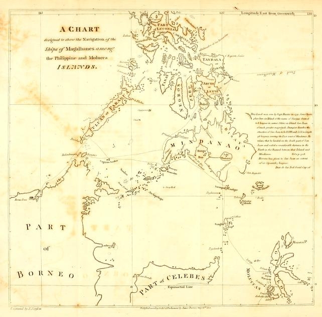
[page break]
[page break]
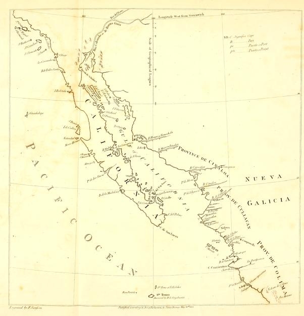
[page break]
[page break]
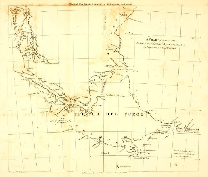
[page break]
[page] 383
nearly in the same latitude, being found in the chart of the track of the Galeon, published with Commodore Anson's voyage, where they are placed within 25 degrees of longitude from the South Cape of California.
The chart and dedication of Rotz, as well as the account cited by M. de Brosses, are proofs that, at that early period, many voyages were undertaken; and, it may be concluded, many discoveries made, of which no account was ever published; that of some, every remembrance has died away; and the various indications that appear in the old charts, to which no clue can be found, may be the remains, and possibly the only remains, of others.
END OF PART I.
[page 384]
[page] 385
APPENDIX.
Remarks on the Projection of Charts, and particularly on the Degree of Curvature proper to be given to the Parallels of Latitude.
THE general Chart of the South Sea, or Pacific Ocean, at the beginning of this volume, is constructed on the principles of the method called the Globular Projection; i. e. of making equal divisions of the Right Circle, to correspond with equal divisions of the Primitive. This method appears, in many respects, better adapted than any other hitherto practised for geographical delineations; and chiefly because it preserves, to equal portions of superficies on the globe, more equality in the representations, and requires in measurement less variation of scale.
It may be noticed, that the measurement of distances by the arc of a great circle, is scarcely ever practised for purposes of geography. To describe an are of an oblique great circle through two given points, is itself a process too tedious to be used in any common case, and where accuracy is required, it is obtained with equal facility, and with greater precision, by calculation.
The Chart of California, and its Gulf, is constructed, in its general principle, as part of a planisphere, whose centre is the pole; the meridians are represented by straight lines, and the parallels of latitude by circles nearly concentric.
The greatest (but unavoidable) error in an hemisphere projected on the plane of the equator, is, that the degrees of longitude at and near the equator, considerably exceed in length the degrees of latitude. Indeed, in every projection of a hemisphere, whatever part falls near the primitive circle, will be represented in the same disproportionate manner; but many of the disadvantages which must be
3 D
[page] 386
submitted to in the representation of a whole hemisphere, are avoided, or in part remedied, in charts of more limited extent.
The intersections of meridian's at the poles, form angles equal to the number of degrees of longitude comprehended between them; and when the meridians are represented by straight lines, any two drawn from the pole to the same parallel circle of latitude, will form an isosceles triangle with the chord of the intercepted arc of the parallel circle. The angles made by the chord with the two meridians, will each be equal to a right angle lessened by one half the degrees of longitude included. For let the arc lmn, represent a given quantity of longitude in any parallel of latitude. Draw the chord ln, and the meridians at l and at n (the pole being supposed the center of projection) must each form with the chord, angles which will be less than 90° by one half the degrees of longitude they include. Upon this reasoning was determined the points through which the parallel circles of latitude were described.
For example, it was required to project lines for a chart extending 10 degrees in longitude, and from the 20th to the 35th degree of North latitude, within which limits California and its gulf are comprehended. The central meridian being first drawn, (which let N S represent, = 900 miles, N being at 35° North, and S at 20° North,) to place meridians at 5 degrees distance, lines were drawn from Nand S, the two extreme latitudes, making angles with the central meridian on the side towards the elevated pole, = 871/2 degrees (90° — 2° 1/2); and on each were measured as many miles in length as are equal to five degrees of longitude in their respective parallels. This gave the points w, w, e, e, for describing the parallel
*
[page] 387
arcs w N e and w S e, w w, and e e, were then joined by straight lines, which completed the outline of the chart. The three meridians were afterwards divided into as many equal parts as were thought necessary, and arcs described through the corresponding points for the parallels of latitude.
[N. B. Short arcs of extensive radii, can be drawn most readily, and with sufficient accuracy, with the instrument called the Shipwrights Bow.]
This method of projection, considering its facility, may be allowed to possess a great degree of comparative correctness.
Having said thus much of its merits, the defects require to be considered. One of the principal errors of measurement in this chart, is the want of extension at the intermediate parallels, of 25° and 30° latitude, where the degrees of longitude are too short about 0,4 of a geographical mile in each degree.
There is however another error of more material consequence. By making all the meridians right lines, they are supposed to have the same constant inclination towards each other in all their parts. The fact nevertheless is, that near the equator, the meridians being all nearly parallel to the polar axis, are in a very small degree inclined to each other. The inclination increases with every additional degree of latitude, till near the poles they point directly to a common center. It is to be noticed in the Chart of California, that by giving to the two extreme parallels their due proportion of length, the original hypothesis, of the inclination of the meridians being every where the same as near the poles, is departed from; and it is likewise rendered apparent, that the angles made by the chords of the parallel arches with the central meridian, are drawn too acute, and differ in quantity from the angles made by the same chords with the next meridian. This defect of symmetry increases with the distance from the central meridian, and is entirely attributable to an error in the curvature of the parallel circles.
3 D 2
[page] 388
The difference of the lengths of the chords of parallel arcs which are intercepted between the same meridians, shows the quantum of approach or of recession of those meridians in different parallels.
In arcs, not exceeding five degrees of a circle, the arch and the chord, not differing in length 1/1000th part, may reciprocally be used for each other, without occasioning any perceptible variation; and it can seldom, if at all, be necessary, that the meridians, whose inclination to each other are to be determined, should be taken more apart than 5 degrees, or at most 10 degrees, of longitude at one time; and this limitation is advantageous in point of correctness, when the longitude is to be set off from a scale of equal parts upon the arcs of parallel circles According to these premises, suppose it is required to find the inclination of two meridians between two given parallels, their difference in longitude being likewise given. mo, np represent two meridians; mn, the given portion of longitude at the higher parallel, and op at the parallel nearest the equator. Draw mq parallel to np; there will be given in the triangle moq, the three sides; oq being the difference between mn and op; and mq not differing in a perceptible quantity from the meridians mo, np.
Then (moq being considered as an isosceles triangle) mo: radius:: oq/2: sine of half the angle omq. And o q being the subtense of so small an angle, it may be said mo: radius:: o q to the sine of the angle omq; that is, radius is to the sine of the inclination of two meridians, as the distance between two parallels is to the difference in the lengths of the parallel arcs.
The length of all parallel arches, between the same meridians, having one and the same proportion to the co-sines of their latitudes, their differences will likewise be to the differences of the co-sines in
[page] 389
the same proportion; i. e. as the distance of the meridians measured at the equator, is to radius.
Let A = the distance between two meridians at the equator; B = the distance between two parallels (their difference in latitude), and x= the difference of the co-sines of the two latitudes. A.X x/radius will be the difference of the lengths of the parallel arcs, and B: A x/radius:: radius: x X A/B.
From this (rather complicated) calculation, results the following easy method for finding the inclination of meridians between two given parallels of latitude. Multiply the difference of the co-sines of the parallels, by the number of the degrees of longitude to be included between the meridians; and the product divided by the number of the degrees of the meridian contained between the parallels, will give the sine of the inclination required.
N. B. The inclination thus found, will be that of the chords of the meridian arcs, which best answer the purposes of projection when the meridians are to be represented by straight lines.
Example. Required the inclination of meridians that are 5 degrees of longitude apart, between the parallels of 20° North, and 35° North:
| 20° Nat. co-sine | 93969 |
| 35° | 81915 |
| 12054 | |
| 5 | |
| 15)60270 | |
| Inclination required 2° 18′ Nat. sine | 4018 |
Consequently, it appears that in the Chart of California, the angles made by the central meridian with the chord of 5 degrees of the parallel arcs, instead of 87° 30′ should have been 88° 51′: and this angle would have preserved uniformity in the direction of the meridians
[page] 390
with the parallel arches. These considerations did not occur till after the Chart was engraved.
The principal use proposed in finding the inclination of the meridians to each other, is to determine the curvature of the parallels. The method which has been described, is proposed to answer that purpose, when the meridians are to be represented by straight lines.
When extension is to be given to the intermediate parallels, and the meridians are to be made circular, different degrees of curvature will be requisite for the different parallels.
Tangents applied to meridians at the same parallel of latitude, will meet at the line of the polar axis produced, in an angle equal to the inclination of the meridians. With two tangents so placed, the distance between the meridians at the proposed parallel, will form the base of an isosceles triangle. The length of any parallel arc (not exceeding the limits before specified) expressed by its equivalent in degrees and minutes of the great circle, may be admitted as the arc of a great circle; thus in latitude 30 degrees, a degree of longitude may be said to be 0° 51′ 58″ of a degree of the great circle; and 5 degrees in the latitude of 60, may be reckoned as 2° 30′ of the great circle. The length of the parallel thus reckoned, may be called the arc of longitude. And the co-tangent of the latitude: sine of radius:: the sine of half the arc of longitude: the sine of half the angle of inclination of the meridians.
To make a Chart of any considerable extent, when the curvature of the two extreme parallels and of the intermediate parallel are determined, and described through a right lined central meridian, the longitudes may be set off with their proper lengths, by as many measurements of 5 degrees on each side the central meridian as are required; and thus are marked three points for each of the other meridians. To enter into more minute explanations, would be lengthening this disquisition beyond reasonable bounds. Upon examination it will be found, that this mode of projection possesses many advantages, and
[page] 391
is susceptible of several auxiliary contrivances, by which accuracy and equality of proportion may be preserved.
The Chart of Terra del Fuego and the Strait of Magalhanes, might be offered as a specimen of projection upon this principle, if the space comprehended were not too small to afford opportunity for comparison between the advantages of different methods.
The Chart of the Philippines is drawn on the Mercator's projection, the defects of which are the less visible, for the space occupied being so near to the equator.
Of the Mercator's projection, it may be said in general, to be more recommended by its facility than by the consideration of any other advantages. In charts where the principal extent is in latitude, the Mercator's projection is peculiarly unfitted (unless for the use of the mariner, to whom it furnishes a ready method of estimating his longitude and the course he is to steer), and they must be tolerable good geographers to whom it does not convey false ideas of magnitudes and positions. This remark may be exemplified by two pieces of land of equal dimensions, one 60 degrees, the other 30 degrees from the equator, laid down in the same chart by Mercator's projection. The former will occupy in the chart just three times the quantity of space which is given to the latter. The degrees of latitude being lengthened as they are removed from the equator, and the degrees of longitude not being diminished, the proportions are increased equally in latitude and in longitude, which amounts in the area to a duplicate proportion; accordingly equal superficies of the earth at 60° latitude, and at the equator appear as four to one.
THE END.