[map] Fugitiva

[page] i
A
CHRONOLOGICAL HISTORY
OF THE
VOYAGES AND DISCOVERIES
IN THE
SOUTH SEA
OR
PACIFIC OCEAN.
PART II.
From the Year 1579, to the Year 1620.
ILLUSTRATED WITH CHARTS AND OTHER PLATES.
BY JAMES BURNEY, 1750-1821.
CAPTAIN IN THE ROYAL NAVY.
LONDON:
PRINTED BY LUKE HANBAED, NEAR LINCOLN'S-INN FIELDS; AND SOLD BY
G. AND W. NICOL, BOOKSELLERS TO HIS MAJESTY, PALL-MALL;
T. PAYNE, MEW'S-GATE; WILKIE AND ROBINSON, PATERNOSTER ROW;
CADELL AND DAVIES, IN THE STRAND; AND NORNAVILLE AND FELL, BOND-STREET.
1806.
[page ii]
[page iii]
ADVERTISEMENT TO THE READER.
SOME Observations which have been made on the First Volume of this History, render it necessary for me to explain to the Reader the method which has been pursued in adducing the authorities throughout the work; and to remark, that from the attention which I have constantly fhewn to original documents, it ought not to be inferred that I have neglected to examine modern collections. These are not admissible as evidence to early facts: but in matters of opinion, and for interpretation of passages in the old narratives, it will be found that writers of late date have been consulted with much advantage.
To each voyage is prefixed, either in a note or as an introductory remark, a short account of the original journals or early publications; and those which have been followed are specified. By this general notice is obviated the necessity of interrupting the narrative with too great a frequency of notes of reference. In all the geographical facts the particular authority is invariably pointed out, and the same rule has been observed in every case where the nature of the fact or the veracity of the original account appeared doubtful. I have been faithful to my authorities, but have no where departed from the respect due to truth, by negligently suffering to pass with silent acquiescence any representation that might impress the reader with a belief which I did not myself entertain. In relating circumstances of suspicious credit, the original authors are called on to speak for themselves, and to their accounts such remarks are added as may assist to remove doubts.
a 2
[page] iv
On many occasions I have cited the words of an original journal for another reafon, and have adopted them in the narrative in preference to any others which occurred. The words of an eye-witness, flowing naturally from first impressions,, are frequently more expressive, and convey ideas more just than studied descriptions; though the language may often be such as it would scarcely be allowable in other persons to write.
Attention has been exerted on every convenience which might facilitate reference to any part of the work. Besides a copious Table of Contents, the head and margin of each page shews the subject matter, the number of the chapter, the date, and place of the transactions there narrated. This I mention, because omission in these particulars occasions much labour to be expended in researches for what such helps would have readily, supplied.
An investigation of the situations of the lands difcovered is given with each voyage, generally at the conclufion of the narrative. In performing this task, I have delivered my opinions. freely on geographical questions, and on a few occasions have offered conjectures; for liable as conjectures are to error, instances must frequently occur where there is a necessity to resort to them. This is experienced by the navigator in seas imperfectly known, where he is inspirited with a degree of confidence if his conjectures, instead of wandering at random, are directed by the knowledge of any circumstance affording, inference that will limit the uncertainty.
In the, second volume, occasion has arisen in two instances to correct geographical errors committed in the first, (see pp. 41 and 349 of Vol. II.) These errors were brought to light by the examination of the journals of two of the voyages contained in this second volume. Throughout the composition of succeffive
11
[page] v
Volumes, the study of a subject is necessarily continued; yet in a long work requiring much search and investigation, there are very fufficient reasons to induce an author to publish by parts rather than to wait until his manuscript is compleated. The most important of these is, to secure an opportunity of revisal in the press; for large manuscripts on scientific subjects, when deprived of the fostering care of their author, are seldom fortunate. If they escape total neglect, they often fall into a worse evil, that of being published by a negligent or unskilful editor.
Concerning the extent to which this Work may be continued, I cannot speak with any confidence. As well as I am able to judge from the progress already made, another volume may be expected to carry the History of South Sea Discoveries to the commencement of the reign of His present Majesty.
The authorities and materials from which the Charts and other Plates are formed or copied, will appear in the narrative and in the subjoined list.
LIST OF THE PLATES AND CUTS.
| Chart of the Islands discovered in the South Sea, to the Year 1620, with the Tracks of some of the principal Discoverers | To face the Title. |
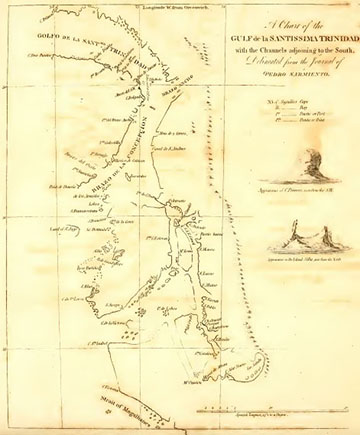
| Chart of the Gulf de la Santissima Trinidad, with the Channels leading to the South. Formed on the authority of Sarmiento's Journal | To face page 9 |
| Chart showing the Islands las Marquesas de Mendoça which were discovered by Alv. de Mendana. Extracted from the Chart of the Marquesas made by Captain Cook in his second Voyage round the World | p. 140 |
[page vi]
| Chart of part of the Santa Cruz Islands. Formed from various authorities, as explained in the narrative | p. 177 |
| Chart of the American Coast from Cape San Lucas to Cape Mendocina. Formed by combining the Plans made by S. Vizcaino in 1602. First published in 1802, in the Atlas to the Voyage of the Spanish ships Sutil and Mexicana | To face p. 256 |
| Balza of Payta, seen in Admiral Spilbergen's Voyage, in 1615. From the Miroir Oost & West Indical. Edit. 1621 | p. 342 |
| Balza of Guayaquil, in 1736. From Don Antonio de Ulloa | p. 343 |
| Chart of the Harbours St. Jago, Salagua, and Natividad. Copied from the Miroir Oost & West Indical | To face p. 348 |
| Chart of the Strait of Manila. From the Miroir Oost & West Indical | To face p. 350 |
| Plan of Port Desire. From Journal du Merveilleux Voyage de Gu. Schouten. Amsterdam 1619 | To face p. 367 |
| Sailing Canoe, met in the South Sea out of sight of land, by Le Maire and Schouten. From Merveilleux Voyage de Gu. Schouten | To face p. 385 |
| View of Cocos and Verrader's Islands. From Merv. Voy. de Gu. Schouten | To face p. 389 |
| View of Eendracht Bay at the Horne Islands. From Merv. Voy. de Gu. Schouten | To face p. 401 |
| Chart of the North coast of Nova Guinea. From Merv. Vog. de Gu. Schouten | To face p. 419 |
[page vii]
CONTENTS OF VOLUME II.
CHAPTER I.
Voyage of Pedro Sarmiento de Gamboa, from Peru to the Strait of Magalhanes, and thence to Europe.
| Page | |
| Ships equipped in Peru, under Sarmiento, for the Strait of Magalhanes | 3 |
| Instructions to the Commanders | ib. |
| Departure from Lima | 5 |
| At Pisco | 6 |
| Description of Sarmiento's Journal, and Method of keeping a reckoning | ib.—8 |
| Gulf de la SANTISSIMA TRINIDAD | 9 |
| Port del Rosario | 10 |
| Expedition in the boat for discovery | 11 |
| The ships anchor in Port Bermejo | 13 |
| Second Boat Expedition | ib. |
| Third Boat Expedition | 15 |
| Geographical descriptions within the Gulf de la S. Trinidad | 17–28 |
| Cape Primero | 17 |
| Port Bermejo | 19 |
| Islands Silla, Roca Partida | 21 |
| Cape Sta Lucia | 22 |
| Ancon sin salida | 24 |
| Cape Santa Isabel | 26 |
| Of the chart of the Gulf de la Santa Trinidad | 27 |
| Probability of channels communicating between the Gulf and the Strait of Magalhanes | 30 |
| Sarmiento's opinion concerning the variation of the compass | 31 |
| The ships leave Port Bermejo | 32 |
| The Almiranta separates | ib. |
| The Brigantine is abandoned | ib. |
| Sarmiento enters the Strait of Magalhanes | 33 |
| Port de la Miscricordia | ib. |
| Port Candelaria | ib. |
| Proceedings of the Almiranta | 35 |
| Sarmiento from Port Candelaria | 36 |
| Port Santa Monica | ib. |
| Island de Carlos III. | 37 |
| River de S. Juan. | 38 |
| Attempt to change the name of the Strait | 39 |
| Angostura de S. Simon | 40 |
| Angostura de la Esperanza | ib. |
| Four fathoms bank near C. Virgenes | 41 |
| Lunar Observations for the Longitude | 42 |
| Island Ascension | ib. |
| Azores. Arrival in Spain | 44 |
CHAP. II.
Expedition of Pedro Sarmiento to fortify the Strait of Magalhanes. III conducted voyage and return of two English ships under Edward Fenton and Luke Ward. Spanish Colony founded in the Strait. Distressed condition of the Colony.
| Page | |
| Powerful armament fitted out by Spain for South America | 45 |
| Five ships wrecked. The remainder return to Cadiz | 46 |
| Sail again. Winter at Rio Janeiro | 47 |
| Sail for the Strait | ib. |
| Driven back | 48 |
| Voyage of Fenton and Ward | ib. |
| Sarmiento arrives in the Strait | 51 |
| City del ombre de Jesus founded | 52 |
| Town de San Felipe built | 53 |
| The Colony left without a ship | ib. |
| Sarmiento sails for Spain | 55 |
| Is taken by the English | 56 |
| The Colony neglected by Spain | 57 |
[page viii]
Notice of Formosa. Navigation of Francisco de Gualle, or Gali, from New Spain to the Philippines, and from Macao to New Spain.
| Page | |
| Formosa | 58 |
| Voyage of Francisco Gali | ib. |
| From New Spain to China | 59 |
| Return to New Spain | 59 |
| Lequios Islands | ib. |
| Islands East of Japan | ib.—60 |
CHAP. IV.
Voyage of Robert Witherington and Christopher Lister, from England, intended for the South Sea.
| Page | |
| Lopez Vaz taken prisoner | 63 |
| His History of the West Indies | 63 |
CHAP. V.
Voyage of Thomas Cavendish round the World.
| Page | |
| Departure from England | 64 |
| Sierra Leone | 65 |
| Brasil | 66 |
| Port Desire | 67 |
| T. Fuller's directions for sailing into Port Desire | ib. |
| Rock to the South of Port Desire | 68 |
| Strait of Magalhanes | ib. |
| Spaniards in the Strait | 69 |
| Account of the Colony left by Sarmiento in the Strait | 71 |
| Extract from the Declaration of T. Hernandez | 74 |
| Port Famine | 77 |
| Cavendish enters the South Sea | 78 |
| I. Mocha. I. Sta Maria | ib. |
| Quintero Bay | 79 |
| Morro Moreno | 81 |
| Arica | 82 |
| Paita. Island Puna | 83 |
| Gualtulco | 85 |
| Bay of Compostella. Mazatlan | 86 |
| Cape S. Lucas | ib. |
| Rich Spanish ship taken | 87 |
| Aguada Segura | ib. |
| Of the crew of the Santa Ana | 88 |
| Track of Cavendish across the Pacific Ocean | 89 |
| Ladrones. Philippines. Java | 90 |
| Island Santa Helena | 91 |
| Arrival at Plymouth | 92 |
| Notes by Thomas Fuller | 93 |
CHAP. VI.
Voyage of Andrew Merick to the Strait of Magalhanes.
| Page | |
| Five vessels sail under John Chidley | 95 |
| Merick arrives at Port Desire | ib. |
| Enters the Strait | 96 |
| Takes on board one Spaniard remaining of Sarmiento's garrison | 96 |
| Merick obliged to turn back | ib. |
[page ix]
CHAP. VII.
Second Voyage of Mr. Cavendish.
| Page | |
| Departure from England | 99 |
| Brasil. Town of Santos surprised | ib. |
| Enter the Strait of Magalhanes | 100 |
| Sail back out of the Strait | 101 |
| Captain John Davis lofes company | ib. |
| Proceedings of Mr. Cavendish | 102 |
| His death | ib. |
| Captain John Davis discovers the land afterwards named Hawkins's Maidenland | 103 |
| Sails through the Strait, and enters the South Sea | 103 |
| is three times forced back | ib.-104 |
| Port Desire | 104 |
| Sails for Europe | 105 |
| Remarks on Knyvet's narrative | 106 |
| This the last South Sea navigation in Hakluyt's collection | 107 |
CHAP. VIII
Brief Review of various Reports concerning the Discovery of a North West Passage to the Pacific Ocean. Doubtful Relation of a Voyage by Juan de Fuca. Reports of the Discovery of Islands named Fontacias.
| Page | |
| Report of a discovery by Andres de Urdaneta | 108 |
| Declaration of J. F. de Ladrillero | 109 |
| Thomas Cowles. Martin Chack | 109 |
| Maldonado | ib. |
| Captain James Lancaster, Postscript to his letter | 110 |
| Juan de Fuca | 110 |
| Observations on Michael Lok's account of Juan de Fuca | 115 |
| Reports of Islands Fontacias | 116 |
CHAP. IX.
Voyage of Sir Richard Hawkins to the South Sea.
| Page | |
| Plan of the voyage | 118 |
| Account of the loss of the Great Harry | 120 |
| Hawkins sails from Plymouth | ib. |
| Distillation of fresh water from sea water | 121 |
| Brasil. Worms | 122 |
| The Pinnace deserts | ib. |
| Davis's Southern Islands seen by Sir Richard Hawkins | 123 |
| In the Strait of Magalhanes | 125 |
| Method of sailing penguins | ib. |
| Ducks. Their nests | ib. |
| Island Mocha | 126 |
| Coast of Peru | 127 |
| Spanish armament sent in pursuit of the English | 128 |
| The English escape | 129 |
| Bay de Catames | ib. |
| Hawkins attacked by the Spaniards | 130 |
| Arrows fired from muskets | 131 |
| Hawkins's ship is captured | ib. |
| A relation of Mendana's last voyage seen by Sir R. Hawkins at Panama | 133 |
VOL. II. b
[page x]
CHAP. X.
Second Voyage of Alvaro de Mendana.
| Page | |
| Pedro Fernandez de Quiros sails as pilot with Mendana | 134 |
| Departure from Peru | 135 |
| Island La Madalena | ib. |
| Islands La Madalena, San Pedro, La Dominica, Sta Christina | 140—141 |
| Are named las Marquesas de Mendoça | ib. |
| Port Madre de Dios | 142 |
| Natives. Their habitations | 144 |
| Canoes. Food | 145 |
| The Bread Fruit | ib. |
| Islands de San Bernardo | 147 |
| La Solitaria | ib. |
| Island Santa Cruz discovered | 140 |
| The Almiranta missing | ib. |
| Volcano Island | ib. |
| Santa Cruz | 150 |
| La Graciosa Bay | 156 |
| Discoveries made by Don Lorenço in the frigate | 158 |
| Spanish town built in la Graciosa Bay | 160 |
| Death of Alvaro de Mendana | 162 |
| The frigate sentin search of the Almiranta | 163 |
| The Spaniards abandon their town | 164 |
| La Guerta Island | ib. |
| Description of Santa Cruz | 166 |
| The ships sail from Santa Cruz | 169 |
| Island discovered in 6° N | 170 |
| The Capitana arrives at Manila | 172 |
| Unfortunate catastrophe of the frigate | ib. |
| Remarks on the situations of the lands discovered in the second voyage of Mendana | 173 to 179 |
| Perplexity created concerning the Salomon Islands | 180 |
| Quiros goes to Spain | 181 |
CHAP. XI.
The ship San Agustin wrecked on the Western coast of North America. Expedition of Sebastian Vizcaino to California.
| Page | |
| Wreck of the San Agustin | 182 |
| Vizcaino sails to California | 183 |
| Settlement formed at Puerto de Cortes | ib. |
| The Almiranta sent within the gulf | ib. |
| Her boat overpowered by the natives of California | 184 |
| The settlement at Puerto de Cortes abandoned | 185 |
[page xi]
CHAP. XII.
Voyage of Five Ships of Rotterdam, under the command of Jacob Mahu and Simon de Cordes, to the South Sea.
| Page | |
| Equipment | 187 |
| Departure from Holland | 188 |
| Mahu dies. De Cordes succeeds | ib. |
| They arrive in the Strait of Magalhanes | 189 |
| Winter in the Strait | 190 |
| Bay de Cordes. Bay de Chevaliers | ib. 191 |
| Enter the South Sea | ib. |
| The fleet are separated | 192 |
| Course pursued by the Admiral | ib. |
| Death of De Cordes, and of the Vice Admiral | 193 |
| Island Sta Maria | ib. |
| Two ships sail for Japan | 194 |
| Islands in 16° N | ib. |
| Of the Islands Gaspar Rico | 195 |
| Las Colunas | ib. |
| One ship arrives at Japan | 196 |
| William Adams, his Account | ib. |
| D. Gherritz discovers land in 64° S | 198 |
| One ship sails to the Moluccas | 199 |
| Sebald de Weert | ib. |
| Takes prisoner a native woman in the Strait of Magalhanes | 200 |
| Meets Olivier Van Noort | 201 |
| Parts from Van Noort | 202 |
| Penguin Islands. A Patagonian woman | ib. |
| Davis's Southern Islands | 203 |
| Islands in 16° N. Gherritz' land | 204 |
CHAP. XIII.
Voyage of Olivier Van Noort round the World.
| Page | |
| Departure from Holland | 206 |
| Prince's Island | 207 |
| Coast of Brasil | 208 |
| Island Sta Clara | 209 |
| Punishment for mutiny | 210 |
| Island San Sebastian | ib. |
| Port Desire | ib. |
| Cape Virgenes | 212 |
| Strait of Magalhanes | ib. |
| A native tribe exterminated by Van Noort's men | 214 |
| Cape Froward. Olivier's Bay | 216 |
| V. Noort enters the South Sea | 219 |
| Vice Admiral loses company | ib. |
| Island Mocha | 220 |
| Valparaiso. Guasco | 222 |
| Arequipa. Dry fog | 223 |
| Sails from the coast of America | 224 |
| Juan de S. Aval. His description of the coast of America | ib. |
| Ladrones | 225 |
| Philippine Islands. Bay la Bahia | 226 |
| Capul | 227 |
| V. Noort arrives off Manila | 229 |
| Ant. de Morga attacks the Hollanders | 230 |
| Ship of de Morga sunk | 231 |
| The Dutch Vice Admiral taken | 232 |
| Borneo. Java. Sta Helena | 233 |
| V. Noort arrives in Holland | 234 |
b 2
[page xii]
CHAP. XIV.
Spanish ship seized by the Natives of the Ladrone Islands, Voyage of Sebastian Vizcaino, to examine the Western coast of California, and the continuation of the coast Northward.
| Page | |
| Spanish ship taken by the natives of the Ladrones | 235 |
| Expedition undertaken to the NW coast of America | 236 |
| Vizcaino sails from New Spain | 237 |
| Bay de San Bernabè | 238 |
| Bay de la Magdalena | 239 |
| Bay de Sta Marina | 240 |
| Bay de Sta Maria | 241 |
| Bay de S. Christoval | ib. |
| Bay de Ballenas | ib. |
| Island de la Asuncion | ib. |
| Pelicans | ib. |
| Island San Marcos. Island S. Roque | 242 |
| Port S. Bartolome | ib. |
| A gum found there like amber | 243 |
| Sierra Pintada | ib. |
| Morro Hermoso | ib. |
| Island la Natividad | ib. |
| Isle de Cedros | ib. |
| I. San Geronimo. I. de Cenizas | 244 |
| Bay de S. Simon y Judas | 245 |
| Bay de Todos los Santos | 246 |
| Islands los Coronados, or de S. Martin | 247 |
| Port de San Diego | 247 |
| Island Sta Catalina | 248 |
| Of the inhabitants. Their manner of fishing | ib. |
| Island San Clemente | 249 |
| Canal de Sta Barbara | 250 |
| Mount Santa Lucia | 251 |
| River del Carmelo | ib. |
| Point de Pinos | ib. |
| Monterey | 252 |
| The Ahniranta sent back to New Spain | 253 |
| The Capitana and frigate separated | ib. |
| Proceedings of the Capitana | ib. |
| Cape Mendocino | 254 |
| Cape Blanco de S. Sebastian | ib. |
| The Capitana returns to New Spain | ib. |
| Proceedings of the frigate | ib. |
| Cape Blanco and river of Martin de Aguilar | 255 |
| Of the natives of the NW coast | 256 |
| Remarks on Vizcaino's chart | 257 |
| Plan formed for another expedition | 258 |
| Vizcaino dies, and the plan is laid aside | 259 |
CHAP. XV.
Concerning the Navigation from New Spain to the Philippines, and the Return from thence to New Spain: and of the Islands Rica de Oro and Rica de Plata.
| Page | |
| Ant de Morga's description of the passage from New Spain to the Philippines | 260 |
| The return to New Spain | 261 |
| Enquiry concerning the Islands Rica de Oro and Rica de Plata | ib. |
| The Ginsima and Kinsima of the Japanese | 262 |
| Informations taken from Spanish pilots at Manila | 263 |
| Attempts made to discover them | 265 |
| Rica de Oro of the Spanish charts | 266 |
| The Lot's Wife of Mr. Meares | 267 |
| Rica de Plata | ib. |
7
[page xiii]
CHAP. XVI.
Preliminary to the Discoveries of Pedro Fernandez de Quiros.
| Page | |
| Report of ships sailing to the Salomon Islands in the year 1600 | 268 |
| Note in Purehas | 269 |
| Accounts published of the voyage of Quiros | 271 |
| Narrative written by De Torres lately discovered | 272 |
CHAP. XVII.
Voyage of Pedro Fernandez de Quiros.
| Page | |
| Quiros sails from Peru | 273 |
| Island la Encarnacion | 274 |
| San Juan Bautista. Santelmo | 275 |
| Los 4 Coronados | ib. |
| S. Miguel. Conversion de S. Pablo | 276 |
| La Dezena | ib. |
| La Sagittaria | ib. |
| La Sagittaria of Quiros believed to be Otaheite | Note in 281–282 |
| La Fugitiva | 282 |
| La del Peregrino | 283 |
| De la Gente Hermosa | 284 |
| Taumaco | 287 |
| Tucopia | 293 |
| N. Sena de la Luz | 294 |
| Santa Maria | 295 |
| Bay de S. Felipe y Santiago | 298 |
| Australia del Espiritu Santo | 299 |
| Port de la Vera Cruz | ib. |
| Australia del Espiritu Santo | 300 |
| Soil. Vegetable produce | 306 |
| Animals. Birds | ib. |
| Fish. Pearl oysters | 307 |
| Silver ore | 308 |
| Climate and temperature | ib. |
| Inhabitants. Their knowledge in the arts, and state of civilisation | 309 |
| Proceedings of Quiros from the Bay de S. Felipe y Santiago | 310 |
| Sails to New Spain | 311 |
| Proceedings of L. V. de Torres | ib. |
| South coast of New Guinea | 312 |
| Passage of de Torres between New Guinea and the Great Terra Australis | ib. and 313 |
| The Great Terra Australis twice seen in 1606 | 314 |
| De Torres arrives at Manila | 316 |
| Farther account of Quiros | ib. |
| Enquiry concerning the situations of the lands discovered by Quiros and de Torres | 318 |
| Regulation suggested for the advancement of Maritime Geography | 319 |
| Table of Situations | 325 |
[page xiv]
CHAP. XVIII.
Voyage of Admiral Joris Spilbergen, round the World.
| Page | |
| Increase of the power of the Dutch in the East Indies | 329 |
| Fleet under Admiral Spilbergen departs from Holland | 331 |
| At Brasil | ib. |
| Strait of Magalhanes | 333 |
| Enters the South Sea | 334 |
| Island Mocha | 335 |
| Island Santa Maria | 336 |
| La Conception. Valparaiso | 337 |
| Quintero. Arequipa | ib. |
| The Holland fleet and Spanish fleet meet | 338 |
| Victory gained by Spilbergen | 339 |
| Callao. Payta | 340 |
| Isle de Lobos | 341 |
| Embarcation called Balza | ib. to 345 |
| Coast of New Spain. Acapulco | 346 |
| Salagua. Santiago | 347 |
| Port de Navidad | 348 |
| Islands Santo Tomas | ib. |
| La Annnblada | ib. |
| Roca Partida of Villalobos | 349 |
| Ladrones. Philippines | 350 |
| Arrival at the Moluccas | 351 |
| Anecdote of Admiral Spilbergen | 353 |
CHAP. XIX.
Voyage of Jacob Le Maire and Wilhelm Cornelisz Schouten, round the World.
| Page | |
| Enterprising speculation on which this expedition was undertaken | 355 |
| Account of the early publications of the voyage | 357 |
| Equipment | 361 |
| Departure from Holland | 362 |
| Cape Verde. Sierra Leone | ib. |
| Dorados, or Dolphins | 363 |
| Port Desire | 364 |
| Provisions obtained there | 365 |
| The Ilorne galiot burnt by accident | 365 |
| Fresh water found | ib. |
| Explanations to plan of Port Desire | 367 |
| Davis's Southern Islands | 369 |
| Tierra del fuego | ib. |
| Schouten's account of the discovery of a New Strait | 370 |
| Cape Home | 371 |
| Name of Strait Le Maire given to the newly discovered Strait | 372 |
| Remarks on the name | ib. |
| Island Juan Fernaudez | 374 |
| Honden Island | 376 |
| Sondergrondt | 378 |
| Waterlandt | 382 |
| Vlieghen Island | 383 |
| A strange vessel seen | 384 |
| Cocos Island | 387 |
| Verrader's Island | 394 |
| Goode Hope Island | ib. |
| Home Islands | 399 |
| Eendracht Bay | 401 |
| Natives of the Home Islands described | 412 |
| Habitations | 413 |
| Of the situation of Eendracht Bay | 414 |
| Groupe of small Islands | 416 |
| Another groupe, named Marquen | 417 |
| Groene Islands. Island of St. Jan | 418 |
| Land discovered, supposed to be the East Cape of New Guinea | 419 |
| Sail along the North coast | ib. |
| The 25 Islands | 424 |
[page xv]
| Papua or New Guinea | 425 |
| Vulcan's Island | ib. |
| Navigation along the North coast of Papua | 426 |
| Description of the natives | ib. |
| Islands Moa and Insou | 428 |
| Arimoa | 430 |
| Schouten's Island | 432 |
| Its Western point, named Cape de Goede Hoop | ib. |
| A bank | 434 |
| Maba | 434 |
| Arrival at the Moluccas | 435 |
| Java | 436 |
| The ship of Le Maire and Schouten seized by the Dutch East India Company | ib. |
| Death of Jacob Le Maire | 438 |
| W. Schouten returns to Europe | ib. |
| Vocabulary of the languages of the South Sea Islands | 440 |
CHAP. XX.
On the Situations of the Discoveries of Le Maire and Schouten.
| Page | |
| Explanation of the method pursued in estimating the situations | 448 to 452 |
| Table of situations | 453 |
CHAP. XXI.
First certain Knowledge obtained of the Great Terra Australis, Expedition of Bartolomé Garcia de Nodal and Gonçalo de Nodal to examine Strait Le Maire.
| Page | |
| The Great Terra Australis discovered by Theodoric Hertoge | 456 |
| Ships fitted out by Spain to examine Strait Le Maire | 457 |
| Rio Janeiro | 458 |
| Regular soundings near the coast of South America | ib. |
| Ledge of rocks, South from Port Desire | 459 |
| Cape Virgenes. Canal de San Sebastian | ib. |
| Strait Le Maire | ib. |
| Variation of the compass | 460 |
| B. de Buen Suceso. Cape Home | ib. |
| Isles of Diego Ramirez | ib. |
| The Tierra del fuego circumnavigated | 461 |
| Natives in the Strait of Magalhanes | ib. |
| Their accuracy of pronunciation | ib. |
| The Nodales return to Europe | ib. |
| Spurious account of this expedition published at Amsterdam | 462 |
[page xvi]
APPENDIX.
N° I.
Relation of Luis Vaez de Torres, concerning the Discoveries of Quiros, as his Almirante. Dated Manila, July 12th, 1607.
| Page | |
| Being a tranflation nearly literal, by Alexander Dalrymple, Esq. from a Spanish manuscript copy in his possession | 467 |
N° II.
| Information collected from the natives of Islands in the South Sea, by Pedro Fernandez de Quiros, in1606, and inserted by him in his memorials, concerning undiscovered lands situated in the neighbourhood of the Australia del Espiritu Santo | 479 |
ERRATA.
| Page 32, | line 9, and in margin |
for Almirante read Almiranta. |
| 33, | line 9, | for fashoras read fathoms. |
| 158, | line 9, | for Figuerora read Figueroa, |
| 271, | line 4, | for 1506 read 1606. |
| 413, | line 21, | for ner read nor. |
[page 1]
A
HISTORY
OF THE
DISCOVERIES
IN THE
SOUTH SEA.
CHAPTER I.
Voyage of Pedro Sarmiento de Gamboa, from PERU to the Strait of MAGALHANES, and thence to EUROPE.
CHAP. I.
THE Spaniards had remained in the quiet and exclufive possession of the navigation of the Pacific Ocean during a space of nearly 60 years, when they were first disturbed by the appearance of European competitors. Other maritime powers, it is true, had endeavoured to discover a navigable communication between the Atlantic and Pacific Oceans, by the North of America; and it can scarcely be affirmed, that the attempt is yet wholly discontinued. The uncertainty of the existence of such a junction did not prevent the fancied communication from being very early distinguished by the appellation of 'the North West Passage.' The ardour for making this discovery was most conspicuous in England, and it continued there long unabated. Three Voyages to the North West had been undertaken in the
VOL. II. B
[page] 2
CHAP. 1.
three successive years 1576, 1577, and 1578, by Captain Martin Frobisher, who discovered the Strait since known by his name, the North shore of which was then believed to be the Continent of Asia. As no termination was found to the opening discovered by Frobisher, the hopes of the English were kept alive; yet so remote and uncertain a prospect of success cannot be supposed: to have occasioned much uneasiness to the Spanish settlements in the South Sea. The attempt of Oxnam had been so completely frustrated, as to leave no apprehension that other attacks would be made across the Isthmus of Darien: but the expedition of Drake, being in the established known route, was of a more formidable nature, and the Spaniards in South America were too well instructed in the influence of successful adventure not to regard it as the prelude to new enterprizes. On their part, they were not wanting in exertions, as well to avenge the injuries they had already sustained, as to provide for the future security of their possessions in the South Sea against similar, invasions.
It has been mentioned*, that Don Francisco de Toledo, the Viceroy of Peru, sent Pedro Sarmiento de Gamboa with ships from the port of Callao, in pursuit of Drake. This fruitless chace was continued along the coast as far as to Panama,, and the Englishmen had great good fortune in its being then discontinued; for the Island Canno, where Drake stopped to refit, is not 100 leagues distant from the Bay of Panama, and he did not sail from that island till the 24th of March (1579), which was twenty-three days after his capturing the rich Spanish ship. It may therefore be deemed extraordinary that during so long a. stay at Canno, his ship should have escaped the observation of either Spaniard or Native, who might have carried the intelligence to Panama.
* Vol. 1ft. p. 336.
[page] 3
1579.
Two ships fitted out from Peru, for the Strait of Magalhanes.
It was known in Peru, that with Drake's ship two others of the fame nation had entered the South Sea; and it was believed that Drake would bend his course homeward by the Strait of Magalhanes. As soon therefore as the vessels which had been sent in pursuit of him returned to Lima, the Viceroy ordered two ships to be equipped for a voyage to the Strait, and appointed P. Sarmiento de Gamboa*, General of the expedition, with the title of Capitan Superior. The ships were the Nuestra Se .jpg"/>ora de Esperanza (which was the Capitana or ship of the Commander in chief), and the San Francisco (Almiranta), commanded by Juan de Villalobos. In the Capitana, Anton Pablos Corzo and Hernando Alonso, sailed as pilots; and in the Almiranta, Hernando Lamero. The whole number of persons embarked were 108, who were equally divided between the two ships, each of which was provided with no more than two pieces of artillery and 20 muskets: they carried with them the frame of a brigantine in feparate pieces, to be set up when there should be occasion.
The account of this voyage will be found rather barren of incident: but the geographical information it communicates is of importance, and the methods of navigating and keeping a ship's reckoning in Sarmiento's time, are more clearly feen in his journal than in the journal of any other navigator which has been published.
Instructions to the Commanders.
The objects of the expedition, as expressed in the instructions delivered to P. Sarmiento, and likewise in a letter written by
* Argensola says, that previous to this appointment, P. Sarmiento had twice fought with Drake; once in the port of Callao, and afterwards in following him towards Panama. Conq. de las Malacas, lib. 5. The inaccuracy of this ftatement appears in a letter from the Viceroy of Peru, addressed to the Governor of Rio de la Plata, wherein the Viceroy writes, 'with great diligence we sent two ships 'in search of this Corsair, but the sea is so wide and he sailed with so much 'expedition, that he could not be taken.' Carta del Virrei, &c. published with fiage al Estrecho por P. Sarmiento de Gamboa, p. lxxx.
B 2
[page] 4
1579.
the Viceroy of Peru, for the Governor of Rio de la Plata, were, to make a careful examination of the Straits of Magalhanes, to endeavour to discover all the entrances that led into it from either Sea, with the breadth of the channels, and depth of water: To obtain every other information which circumstances would permit respecting the Navigation, each ship being particularly directed to keep a careful account of the courses navigated, and to mark all the coasts, and lands discovered, on a chart. The journal or diary of the proceedings were to be publicly read every day in the presence of the officers and pilots, who were required to remark if it appeared to them that there were any omissions or mis-representations; and each ship was ordered to keep four copies of her journal*. All the places in the Strait, which appeared convenient for a settlement, or which might be fortified as stations for guarding the passage, were to be noted Search was to be made after Drake, and, if found, the Spanish. ships were to use their utmost endeavour to take him, and their success was to be liberally rewarded both from the re-captured booty, and by other gratifications which the instructions promised. If other Corsairs were met with, they were to be attacked or not, as should appear most convenient. If any town or settlement was discovered in the Strait belonging to the English, or to any other foreign nation, all circumstances of their
* One of the journals so kept, is preserved among the MSS. in the royal library at Madrid, and was published in 1768, under the title of Viaje al Estrecho de Magallanes, por el Capitan Pedro Sarmiento de Gamboa, en los anos 1579 y 1580. The Editor remarks, in his preface, how great Would have been his satisfaction if he could have given to the engraver the Sea Charts made by Sarmiento; but his greatest diligence could not discover their retreat. He thinks it probable that they were lodged in the Casa de la Contratacion at Seville, or in the Archives of the Convent of San Francisco at Cadiz, 'where are deposited, or, more properly speaking, buried, the journals, obfervations, and original Charts, of the most famous Voyages and Discoveries of the Spanish Navigators.'
Viaje, &c. por Sarmietito: Prologo, pp. iv; xxxvi; xxxvii.
[page] 5
1579.
situation and strength were to be observed and noted. If both the ships arrived in company at the entrance into the North Sea ('Mar del Norte'), the Almiranta was to be sent back to Lima if the winds allowed of her return; if otherwise, she was to make for the Rio de la Plata, to deliver to the Governor of that place copies of the journals, one to be forwarded by him to Spain, and another by land to Peru. Sarmiento was to sail with the other ship to Spain, to lay before his Majesty and before the Supreme Council of the Indies, all the information he should have obtained, that his Majesty might be enabled to order such measures as should effectually bar the passage of the Strait against the vessels of other nations. If the ships were at anytime separated by weather or other accident, the commanders were ordered, notwithstanding such separation, to continue their endeavours to accomplish the purposes of the equipment. Whenever it could conveniently be done, possession was to be taken of the countries in the name of the king of Spain; and observations were to be made on the soil, the produce, and on the customs of the natives, some of whom were to be taken and carried away in the ships, that knowledge might be acquired of their language.
The instructions throughout are drawn up with great attention, to all minute particulars, and they certainly deserve the character of having been dictated with ability.
October. Departure from Lima.
On the 11th of October, 1579, the two ships sailed from the port of Callao. Sarmiento appointed for the place of rendezvous, in case of separation, the first safe port that should be found within the entrance of the Stait of Magalhanes, and either ship on arriving there singly, if she found no indication of the other ship, was to wait 15 days, making signals from the land during that time, and was afterwards to proceed Eastward, leaving notices in the different ports where she should chance to touch.
[page] 6
1579.
October. Pisco.
The 17th, they anchored at Pisco, to repair some defect in the Capitana. At this place they took on board four seamen in addition to their former number. The pay of the seamen employed would appear extraordinary for that age, if it did not enter into the consideration that the ships were fitted out from Peru. 'To three of the men engaged here, the customary wages were given; and one, who was a caulker, received the advantage of being paid as a man and a half, which is 37½ proof pesos (pesos ensayados) each month.*
Description of Sarmiento's journal.
The 21st, the ships sailed from Pisco, towards the South West, with winds from the South East quarter. The journal contains a regular account of the navigation of each day, and the day is reckoned as at present, from noon to noon. The run of each hour is not separately specified; but the different courses steered, and the distance sailed on each course (a few instances of omission excepted) with the winds, are set down in a summary manner, in divisions regulated by the times when any alteration of course or of wind occurred. The latitude is set down whenever found by observation, and generally, at the fame time, the estimated course and distance made good since the observation preceding; with the estimated distance of the ship at noon from some port or station on the American coast; and sometimes the distance from the meridian of Lima.
Such a journal is in form a near approach to the present method of keeping a Reckoning: but all the means of correct computation appear to have been out of reach. In observing for the latitude, Sarmiento and the pilots generally differed from each other more than half a degree; the distances sailed were not measured, but marked from conjecture; and, what is extraordinary in an experienced seaman, it appears to have been
* The pay of the seamen was accordingly, per month, 25 pesos, equal in value to £. 5. sterling.
[page] 7
1579.
October.
disbelieved by Sarmiento that the needle had any such property as variation; all the courses and bearings by compass being received as the true bearings.
The character of this journal will appear in the following extracts:
'Thursday, October 22d. It was calm all day, and towards night Ave were near the island Sangallan, which is in 14 degrees South. Two hours after night-fall the wind sprung up from the SSE, and Ave stood to Seaward SW, all the night, and till Friday noon, having sailed according to our judgement 12 leagues [12 leguas por el arbitrio.]
'Friday, October 23d, from noon Ave sailed WSW till night, 6 leagues. This day the arms and accoutrements were distributed. The whole night Ave sailed SW a little Southerly, 8 leagues by conjecture [ocho leguas por fantasia.]
Another extract from the journal:
'From Monday to Tuesday at noon, the 27th of October, with moderate winds from the SE and SSE Ave steered on courses from SW to SSW. The sky was clear, and the sea smooth. We observed this day the latitude; Pedro Sarmiento, in 19° 22′ S; Anton Pablos, in 19° 50′ S; Hernando Alonso, in 19° 05′ S, according to which, from Monday noon to Tuesday noon, we have gone SWbS 28 leagues. The currents have set to windward in our favour (to the South). We are this day East and West with the River of Juan Diaz, distant 140 leagues. For this Sea, we saw but few fish; and, of birds, we saw some white boobies. Hailed the Almiranta to ask her pilot what latitude he had made; and he answered that he had not taken the Sun this day, though the weather was fair for so doing. Pedro Sarmiento reprehended him for his negligence, and ordered that hereafter he should not omit
[page] 8
1579.
'to observe for the latitude on every day that the sky was clear' enough for that purpose.'
The care and attention observable in this journal deserve commendation. It has been censured for being prolix, and (with more reason) for magnifying the hardships and dangers that were encountered. Almost every escape is represented as miraculous, and the exertions of the Spanish seamen as supernatural: these representations, with the frequent recurrence of pious ejaculations, occupy much room in the journal. There appears, likewise, an ambition in Sarmiento to imitate the actions, and to emulate the fame of Magalhanes: speeches of the officers and pilots endeavouring to dissuade him from proceeding farther, are entered in the journal, with his answers declaring his resolution not to abandon the work he had undertaken; and this species of affectation is continued after the difficulty had been so far conquered, that to proceed was become more easy than to return. In many other respects, the length of his remarks are advantageous; and it may be fairly observed, that very few sea journals of the present day, if like this they were published in the state they were written, would be found less charged with remark of little moment.
November.
November the 1st, they passed within 18 leagues, by their reckoning, to the West of the islands San Felix and San Ambor; but did not see them. It is a curious circumstance, that Sarmiento and his officers knew so little concerning the first navigation across the South Sea, as to suppose that these islands were the Desventuradas of Magalhanes.
In latitude 33° South, being then by the reckoning 140 leagues to the West of the meridian of Lima, the winds became variable, and the course was inclined towards the land; but at the same time with so Southerly a direction, that they did not regain sight of the American coast till they had passed the 49th degree of South latitude. Complaints are made in the journal of the
7
[page break]
[page break]
[page] 9
1579.
conduct of the Almirante* in this passage, charging him with an intention to separate.
November. 17th.
Gulf de la Santissima. Trinidad.
November 17th. In the morning land was seen to the East South East, towards which the ships stood. At noon the latitude was observed 49° 30′ S: by the observation of the pilot H. Alonso 49° 09′ S. A large and deep opening was seen running in to the South East, and at a great distance within, there appeared a chain of mountains covered with snow. This bay or gulf, the General named de la Santissima Trinidad. The land forming its Southern coast was steep and rocky, and near the shore were many rocks above water: on its outer cape was a mountain which had three peaks, for which reason the Cape was named de Tres Puntas. All the land near the coast had a rugged and broken appearance.
After a short consultation with the Almirante, the ships steered for this opening, with the intention to examine if it would lead to the Strait of Magalhanes. As they stood in, they sounded,
* Almirante was the title of the officer second in command, as Almiranta was of the ship commanded by him. The name is derived from lhe Saracens, as is our word Admiral from the Spanish Almirante. 'Mir. An abbreviation of Emir, which signifies in Arabic, Chief, Prince, and Commandant. The Persians and Turks frequently ufe this abbreviation.' Al is lhe Article 'The.' D'Herbelot. Bibliotheque Orientale. In the Lime of the Crusades, it signified a Commander by land, rather than a Naval Commander, or perhaps applied indifferently to either. 'The Turks lost on this occasion thirty-two Admirals (so were called their men of the greatest renown and distinction), and 7,000 car casses were found in the field.' Ricardi iter Hierosolym. apud Gale. Hist. Angl. Scrip. Vol. II. p. 360. See also Spelman of Admir. Jurisd. wherein is the following quotation. 'N. Trevet saith, that in the great ship of the Saracens, which he calleth a Dromond, taken by K. Richard I. there were seven Amirah.'
The Spaniards made the title peculiar to Sea Commanders, either before or in the time of Alphonso IX. King of Castile (1158 to 1214). Almirante: el que es cabdillo de todos los que van en los navios para fazer guerra sobre mar [Almirante: he who is the Chief of all those who go in ships to fight upon the Sea.] Quoted by Du Cange. Glossarium. med. Lat. T. 1. p. 169. under the word Amiralins. It afterwards became with the Spaniards the title of the second in command of a fleet.
VOL. II. C
[page] 10
1579.
November Gulf de la Trinidad.
but no bottom was found with much length of line, till they drew near to the shore on the Southern side, where the Capitana anchored in 30 fathoms, 5 leagues within the outer capes; but the bottom being foul, she could not remain at this anchorage, and both the ships ran nearer to the South shore, where they anchored in 20 fathoms, the bottom rocky, and their situation exposed to winds from the North West; but the coast was bold [steep] and clear.
18th.
The 18th. The General and the pilots went with the boats, in different directions, to search for a safe port. The General found a tolerable good harbour (Puerto razonable) to the South East; but the pilot of the Almirante did not return in time for the ships to be moved that day.
19th.
The next morning the wind blew strong from the North, which being directly on the nearest shore, rendered it dangerous to get under sail. In this situation, the Capitana parted from her anchors, and was nearly driven on the rocks, but her other anchors held her. The remainder of the 19th, and all the following day, the ships continued in the same situation, and in great danger, the gale not abating.
21 st.
Puerto del Rosario.
The 21st, the pilot, H. Alonso, was sent to examine if there was sufficient depth of water for the ships within a small island near the land to the South of them; and between the larger land and this small island, a narrow port was discovered, with anchorage at 5 fathoms depth, into which the ships were taken, one after the other, and within was found good shelter. This port was named Nuestra Seora del Rosario. The anchoring place they had quitted was named by the seamen *Cache Diablo.
Sunday, the 22d. Sarmiento with the greater part of his people went on shore, and erected a cross, and took possession
* Cache, signifies a box on the ear.
[page] 11
1579.
November.
Gulf de la Trinidad.
of the country for King Philip II. On the same day observations were made with three astrolabes, which gave for the latitude 50° South.* Footsteps of people were seen, and some spears, paddles, and fishing nets were found, but no natives appeared. Sarmiento went with some of his men to the summit of a hill, from whence he saw many other harbours and arms of the sea, and counted 85 islands, large and small, and the broken appearance of the land on which he stood, made him suppose it to be one of an archipelago of islands. The General determined to leave the ships in Port del Rosario, whilst with one of the boats he examined farther within the gulf.
Expedition in the boat on difcovery.
On Wednesday the 25th, Sarmiento, accompanied by the pilots Anton Pablos and Hernando Lamero, and ten mariners, with arms, and provisions for four days, departed in the boat of the Almiranta.
They followed the direction of the coast from Port Rosario, keeping near the right hand shore of the gulf, which led first towards the East and South East, and afterwards to the South and South West. In this excursion, they examined above 20 leagues of coast, within which extent were found many harbours and inlets. The geographical descriptions and remarks are much dispersed in the original journal, for which reason it has been thought necessary to collect the most material parts under one head. For the present they will be only occasionally and generally noticed.
On the 3d day from Port Rosario, they entered a harbour which was judged to be a convenient station for the ships, from whence the farther examination of the gulf and the canals communicating with it might be prosecuted in the boats. This
* The latitudes in the chart are governed by the latitude of Cape Tres Puntas, as found by late observations, and by the distances and bearings given in Sarmiento's journal.
C 2
[page] 12
1579.
November.
Gulf de la Trinidad.
harbour, on account of a red sandy beach within it, received the name of Puerto Bermejo (the Red Harbour). Beyond Port Bermejo, to the South Weft, was clearly difeerned a free passage to the open sea, in which direction the boat proceeded 3 leagues farther, and then turned back towards the ships; their stock of provisions being nearly consumed.
The land by which the boat went was craggy and mountainous, but in many parts covered with wood. Among the trees seen are mentioned Cypresses, Savins, Holme, (Acebos, Carascas) Myrtles; befides which there was brush wood or furze, other herbage, and berries.
The birds seen were 'black Geese, by some called Sea 'Crows'*, Penguins, Gulls, and other sea fowl, among which is mentioned and described the Tropic bird†. In the woods there were thrushes and other singing birds, owls and hawks of various kinds. By the sea shores, shell fish were found in great quantity, and in the muscles many small pearls.
The wind, during this excursion, blew constantly from between the North and West, sometimes strong. In the return, they rowed the greater part of the way, and were necessitated, officers as well as men, to exert themselves at the oars as the only means of protection against the cold.
December.
They rejoined the ships in Port Rosario, December the 1st; the journal says 'having gone outward and in their return more than 60 leagues, in sounding ports, channels, bays, inlets, and banks; in putting names and marking the courses and latitudes. The whole that was discovered was drawn (pintando) and written by the General openly before those who accompanied him, Anton Pablos and Hernando Lamero, the pilots.'
* Patos negros, á que otros llaman Cuervos Marinos. Viaje por Sarmiento, p. 94.
† Rabos de Juncos. There is perhaps no similar instance to be found of the Tropic bird being in so high a latitude.
3
[page] 13
1579.
December. Gulf de la Trinidad.
December the 2d. Boats were sent to endeavour to recover the anchors parted from at the first anchoring place; in which they did not succeed.
The 3d and 4th, a strong gale. The Almiranta was in some danger of being driven against the rocks. Her commander, Juan de Villalobos, and several of his people following his example, sought their own safety by going on shore, where they remained till the violence of the gale was past; for which 'they were reprehended with moderation' by P. Sarmiento.
The ships anchor at Port Bermejo.
Monday the 7th. The ships left Port Rosario. At noon they were in the channel between an island named En medio (Island in the middle) and the entrance of a wide arm of the sea (brazo anchoj). In the evening of the same day, they anchored in Port Bermejo. Here the General ordered the brigantine, the frame of which had been brought in separate pieces, to be set up; but as this would be a work of some time, on December the 11th, he departed in the boat of the Capitana, which was named the Santiago, to renew the examination of the inlets, taking with him the pilots Pablos and Lamero, and fourteen seamen (soldados marineros), with arms, and provisions for eight days.
Second Boat Expedition.
They left Port Bermejo at eight in the morning. Their first course was towards the South West, to Point Animciada, and afterwards their progress was towards the South. In the evening of the first day they put into a bay which they named De San Francisco, intending there to pass the night. They had scarcely landed, when one of the soldiers shot at a bird, and immediately the report made by the gun was answered by the shouts of people on the opposite side of the bay. Sarmiento embarked again, and went thither with the boat, where he found a number of natives, whose bodies were painted. One of them, an old man, appeared to have authority over the rest. The Spaniards approached, making signs of peace, and Sarmiento gave them
[page] 14
1579.
December. Gulf de la Trinidad.
some gloves and a handkerchief; the pilots and seamen likewise made them presents. Some biscuit and wine was given to them: the biscuit they eat, but the wine, (not much to the credit of the wine of Peru) after having tasted, they threw away. These gifts did not induce the natives to regard the new comers with confidence, and it is probable that the behaviour of the Spaniards gave cause for suspicion, as they were meditating how to entrap some of the natives. This part of the shore, however, was dangerous for the boat; Sarmiento therefore returned to the first landing place, and made signs to the natives to follow. Their curiosity prevailed over their distrust, and they went to the place where the Spaniards had purposed to lodge for the night. Sarmiento caused one of them to be seized and carried into his boat, and to get out of the reach of any attempts that might be made to a rescue or to revenge, he quitted the place, and went with his people and prisoner to pass the remainder of the night at some small islands, which they named la Dormida (the Sleeping Place).
The history of early discoveries exhibits many similar instances of violence committed by European navigators upon the natives of the discovered countries; yet the method practised by Sarmiento fhould not be suffered to pass without notice. He went to meet these people with signs of peace to invite their confidence, whilst his purpose was to deceive them. The motive for this seizure was to procure an interpreter, and to gain some information respecting the coast and country; but in both these objects they were disappointed, for their prisoner, after suffering two days of captivity, escaped, the beat being then at an island near the entrance of a canal, which was named de San Blas, about 10 leagues to the SSW from the Bay de San Francisco.
A cape, to which was given the name of Santa Lucia, about two leagues South West from the entrance of San Blas, was the
[page] 15
1579.
December. Gulf de la Trinidad.
farthest extent of land discovered in this second boat excursion. In the return, Sarmiento stopped at an island named by him Roca Partida,(the cleft rock). At one end of a sandy beach on the Eastern side of this island, is a large cave in a rock, wherein was found a skeleton and the furniture complete (armadura entera) of a native man or woman. Bad weather detained the boat at the island Roca Partida two days and nights. They afterwards went to a bay in the nearest Eastern land, which they named the Bay de Guadalupe, and entered an inlet, where they saw a canoe and some natives; but on the approach of the Spanish boat, the natives abandoned their canoe and fled to the hills. Near the sea shore was a low hut, built with twigs or sticks, and covered with light branches of trees and skins of seals: the furniture found within consisted of baskets, nets, fishing implements, and some red ochre, which last the natives use in anointing their bodies. Other natives were seen, but they all kept at a distance.
Thursday the 24th, Sarmiento rejoined the ships in Port Bermejo, having been enabled, by birds, shell-fish, and herbs, to prolong his absence to 13 days.
The brigantine was not yet quite finished. Some natives had made their appearance in Port Bermejo, and the Spaniards had seized and carried one on board the Almiranta, from whence he contrived to make his escape; and the natives at this place had the prudence not to give the Spaniards such another opportunity.
Third Boat Expedition.
As Sarmiento hoped to find a passage to the Strait of Magalhanes among the canals and broken land which appeared to the South East, he would not lose time by waiting for the brigantine, but renewed his examination, taking the boat of the Almiranta, and the pilots Pablos and Lamero, with twelve mariners, and provisions for ten days. He left Port Bermejo December the 29th.
[page] 16
1580.
January. Gulf de la Trinidad.
In this expedition, Sarmiento penetrated by channels, which he discovered towards the South Eaft and South South Eaft, to the distance of above 30 leagues from Port Bermejo; his farther progress was prevented by the channel which he had navigated to this extent, being found to terminate in a bay near the foot of a ridge of snowy mountains, which seemed to be part of a chain extending from North to South on the land to the East of all the canals which were discovered. This bay, the utmost limit of the discoveries made in the boat towards the South and East, is named in the charts Ancon sin salida(the bay or inlet without thoroughfare).
The return was by a different route, and a great number of channels and islands were discovered, but which did not forward the object of their examination. On a rocky island near the Northern entrance of a canal, which was named the Canal de S. Estevan, some sea otters* were seen.
Tuesday, January the 12th, Sarmiento arrived at Port Bermejo, having been absent on this third excursion a fortnight, in the whole of which he had not met a single native.
The Remarks which immediately follow are entirely geographical and nautical, and will probably be interesting only to navigators, who may be desirous of more particular information than is contained in the preceding narrative, and for whose use they are designed. The difference of the type, as well as a notice prefixed, will show where the narrative part of the voyage is resumed.
* Nutrias. Sarmiento's journal, p. 156.
[page] 17
Nautical Remarks.
Geographical and Nautical Descriptions of the Coasts, Harbours, Islands, &c. within the Gulf de la Santissima Trinidad, and the Channels to the South. From the Journal of P. Sarmiento.
N. B. The bearings are all as taken by the compass; but they were believed to be the true bearings. The distances were set down by estimation. On comparing the charts with these descriptions, it will be seen that some small conciliatory allowances were indispensable. Wherever any material variation occurs, the case is particularly specified.
Remarks previous to the First Boat Expedition.
Cape Primero.
The outer capes which form the entrance of the Gulf de la S. Trinidad, were named Cape Primero* (the First Cape) and Cape Tres Puntas, and are distant from each other 6 [Spanish] leagues. Cape Primero is a high headland: when seen at a distance from the SW, it appears like an island. It lays North a little Eafterly from Cape Tres Puntas. Along the outer coast to the North from Cape Primero are small islands.
From Cape Tres Puntas to Port Rosario, the distance is not specified: the first anchorage was 5 leagues within the outer capes, and the circumstances lead to a belief (which has been adopted in the Spanish charts) that Port Rosario is a small distance farther within the gulf.
Remarks and Observations made in the First Boat Expedition.
Point Candelaria.
From P. Rosario, EbN ¾ of a league, is a point named la Candelaria: midway in this distance an inlet runs in SEbS, near the entrance of which are 23 islands.
Port dela Morro.
From Point Candelaria EbS 500 paces [whether by the pace is meant a single or double step is not explained], a large harbour runs in to the South: the breadth of the entrance is not mentioned. Near the NW point of this harbour the depth is 20 fathoms, clear bottom. On the Southern land within, is a mountain; wherefore this port was named Puerto de la Morro (the Harbour of the Mountain).
* In some charts this cape is named Cape Corso, probably after the pilot Ant Pablos Corso, who wrote a relation of the voyage, but which has not been preserved.
VOL. II D
[page] 18
Nautical Remarks. Pan de Azucar.
From Puerto de la Morro, ESE 1/3 of a league, is a headland; from thence the coast runs SE 1/6 of a league: and SEbS, 2 leagues farther, is a mountain named Pan de Azucar, (the Sugar Loaf). Midway in the last distance a bay runs in SSW.
Ancon del Suclueste.
From the Pan de Azucar, South half a league, is a round mountain, and between these two mountains an inlet runs in to the SW, which was named Ancon del Sudueste (the South-weft Inlet), with 22 fathoms depth, gravelly bottom at the entrance, near which, on the Northern side, is a small round island covered with trees; and within the inlet on the same side, and near the entrance, is a pool of still water, in which a ship may lay close to the shore moored head and stem.
1. de En Medio.
From the entrance of the Ancon del Sudueste Eaft half a league, are some small islands; and near to them, soundings at various depths from 15 to 40 fathoms. Towards the middle of the main stream of the gulf (which in the journal is called the Canal Madre, i.e. the Mother Canal) no bottom was found at the depth of 120 fathoms. A chain of rocks, some of them above water, are mentioned here, but their situation is not clearly described. In the middle of the Canal Madre, and it is said a league East of the rocks, is a small island which was named I. de En Medio, from whence a part of the open sea, without the entrance of the gulf, was seen, bearing NWbW. To the SW of the island En Medio, about a furlong distant (como un ahuste de distancia) is a ledge of rocks; between which and the island is a channel with eight fathoms depth.
Cape Delgada.
From the Ancon del Sudueste, the coast lies SbE one league to a naked mountain: and thence SSE 3/4 of a league to a point named. Delgada (which signifies Slender). Beyond Point Delgada the main canal takes a Westerly direction, and in it is a chain of islands laying from each other NWbW and SEbE.
From Point Delgada, the shore runs one league SWbS, in which distance are two mountains, and to the SE of the Southern mountain is a small bay. Nearly abreast this part, in the middle of the canal, is a round island, and to the West of it are four other islands. These seem to be the chain just before mentioned. The depth near them 40 fathoms.
* Ahuste, a cable's length. Portuguese Dictionary.
[page] 19
Nautical Remarks. Point del Brazo Ancho.
Three leagues farther SWbS [four from Point Delgada] is another point which was named del Brazo Ancho (of the Broad Canal). In this distance are two large openings, with soundings near them from 50 to 20 fathoms, rocky bottom: South of, and near, Point del Brazo Ancho, there is good bottom, depth from 34 to 15 fathoms.
Point Galeotilla.
Hocico de Caiman.
Four leagues SWbS from P. del Brazo Ancho, is a point named Galeotilla (which signifies a small Galley), and three leagues SWbS from Point Galeotilla, is a point which was named Hocico de Caiman (the Crocodile's Snout).
Port Bermejo.
On the North side of the Hocico de Caiman is a port, with anchorage from 14 to 7 fathoms. The coast continues half a league South West from the Hocico to a point of land, to the NW of which is a good harbour, within which is a red sandy beach; and it was therefore named Puerto Bermejo de la Concepcion. In this port there is secure anchorage in depth from 6 to 9 fathoms, a clear sandy bottom, where vessels may lay protected from all winds; and close to the shore is a good run of fresh water. In the mouth of the harbour is a mountainous island, by which two entrances are formed. The entrance to the North East is rendered the narrowest by a shoal which runs off from the island: the depth in this channel is 4 fathoms at low water. In the other entrance, there was 7 fathoms depth, and the deepest part of the channel was near the island.
Brazo de la Concepcion.
From P. Bermejo, a continuation of the Canal Madre ran South West 6 leagues, where it joined the open sea, which was clearly seen and ascertained from the hills in Port Bermejo. This part of the main Canal, or Canal Madre, was named Brazo de la Concepcion. Another canal was seen, which ran in a WNW direction, and was supposed to pass through to the open sea.
Point Anunciada.
Brazo del Oeste.
From Port Bermejo South West 3 leagues, is a low point which was named de la Anunciada; and in the middle of this distance, a canal or arm of the sea, a league and a half wide at its entrance, runs to the WNW, which was named Brazo del Oeste (the Western Canal). [This seems to be the canal which was seen from the hills in Port Bermejo.]
It may be supposed that there were more openings in the land between Port Rosario and Point Anunciada than have been particularized; as the journal describes the coast to be much broken and pierced by canals; in each of which were seen islands.
D 2
[page] 20
Nautical Remarks.
In the first boat expedition, the Eastern coast of the Gulf was at too great a distance for minute description; but the following remarks were made:
Eastern Shore of the Gulf.
Canal del Brazo Ancho.
NEbE from Point del Brazo Ancho is an opening in the opposite shore, which is 3 leagues wide at its entrance, and runs NE towards a chain of snowy mountains. This opening was likewise named del Brazo Ancho. To the North of its entrance, the coast of the Gulf turns in a North Westerly direction with inlets and islands 'more than could be reckoned.'
Abra de Tres Cerros.
From the same Point del Brazo Ancho SEbS is an inlet, which was named Abra de Tres Cerros (Inlet of the Three Mountains).
Canal de S. Andres.
From Point Galeotilla EbS 4 leagues, is an opening a league wide at its entrance, which was named Canal de San Andres. Two leagues North of this is another canal running to the North East; and to the West of its entrance, in the middle of the Canal Madre, is a small island.
The latitudes observed within the foregoing extent are inserted at the end of the Geographical Remarks. They are to be regarded as more liable to error than any other particulars of Sarmiento's survey.
Geographical Remarks made in the Second Boat Expedition.
Point Pea de Francia.
From Point Anunciada, the coast runs ¼ of a league SW, and thence SWbW 2 leagues, but with two small bays in that distance, to a point which was named Nuestra Sena de la Pe a de Francia (our Lady of the Rock of France): and near the point, there is a small rock.
Cape Santiago.
From Point Anunciada was seen, far out towards the sea, a high cape 'of the land on the left,' bearing from Anunciada SWbS a little Westerly, 6 leagues distant; this cape was named Santiago.
From Point Anunciada, SE 2 leagues, is a small island, and beyond it, a chain of 7 small islands, laying NE and SW, the whole occupying a space one league and a half in length.
Brazo de le Arrecifes
From Point Anunciada SbE a little Easterly, distant 3 leagues, in the opposite shore of the Brazo de la Concepcion, is a rocky bay, which was named de los Arrecifes. From the SW point of this bay, to
[page] 21
Nautical Remarks.
Islands S. Buenaentura, and de Lobos.
the SSW, 1½ league distant, is a small island, which was named San Buenaventura (Saint Goodfortune). A smaller island NbE half a league from San Buenaventura, was named de Lobos, i. e. the Island of Seals or Sea Calves; some of those animals of very large size being seen there. Near the Isle de Lobos was found 8 fathoms depth, the bottom stony, with much sea weed; a reef or ledge of rocks extended from one to the other island. Cape Santiago bore from Lobos SWbS distant about 4 leagues. [This bearing of Cape Santiago ill agrees with the bearing taken from Point Anunciada, and places the Cape more to the South].
Bay of S. Francisco.
Point de la Gente.
In the land from the SW point of the bay de Arrecifes to abreast Buenaventura Island, is a deep bay or inlet; and about a league and a half farther, is a point, and a bay which was named the bay of San Francisco. The Southern point of the bay was named Punta de la Gente (Point of the People), because some natives were seen there.
La Dormida Isles.
To the South of P. de la Gente is another deep inlet, and the shore is much broken. SSW one league from P. de la Gente, and near the coast, are three small islands in a triangular position, which were named la Dormida: they are East and West with the land of Cape Santiago.
Island Silla.
From la Dormida SbW 3 leagues, and from Cape Santiago SE Easterly 6 leagues, is a high mountain on an island which was named Silla (the Saddle). Between Silla and the Eastern land was found a strong current or tide running from the North, and in the channel are rocks and shoals which extend 1½ league towards the grand canal. In the Eastern land from abreast of la Dormida to abreast of Silla is a large opening, with many small islands, rocks, and patches of sea weed.
Within half a league to the NW of Silla likewise are 18 small islands; and SWbS from Silla one league, are breakers.
Island Roca Partida.
From Silla SWbS 2½ leagues, is an island which was named Roca Partida, near the East side of which is good anchorage for small vessels, half a mile from the shore, and opposite to a sandy beach; the depth is 7 fathoms, but the bottom is rocky. On the North part of the island, there is fresh water and wood. Near the NE part are rocks. The island is distant from the land to the East one league and a half.
[page] 22
Nautical Remarks.
From Roca Partida WSW 2 leagues, are two rocky islands, from which a range of rocks and breakers extends a considerable distance to the West, likewise to the North and NE.
Cape Sta Lucia.
From Roca Partida, Cape Santiago bears NNW; and a high headland, which was named Cape Sta Lucia, SWbS 5 leagues.
Canal de S. Blas.
From Roca Partida towards Sta Lucia, the sea is full of small islands and rocks; and about 2 leagues before arriving at Cape Sta Lucia, in the land contiguous to it, is an opening that runs in to the SSW, which was named the Canal de San Blas; in the entrance are small islands. This inlet was examined, and no passage through was found.
Bay of Guadalupe.
ENE from Roca Partida is a bay named Guadalupe. There are two inlets in the bay; one leads to the East, and one to the North. The Northern inlet, after quitting the bay, divides into two branches; one leading Eastward; the other runs in a serpentine direction towards the NE 3 leagues, and turns short round WbS 1 league, and SW half a league, where it again meets the open sea, a league from the Bay of Guadalupe, and nearly opposite to the Island Silla.
Geographical Remarks made in the Third Boat Expedition.
I. los Iocentes.
Point S. Juan.
From Port Bermejo SEbE 2 leagues, is an island one league in length from NNW to SSE, which was named los Iocentes, and 4 leagues farther to the SE is a point on the Eastern shore of the Brazo de la Concepcion, which was named San Juan.
From los Iocentes SSE is a large canal; and NE from the same island is another.
On the North side of Point S. Juan is a bay; and a league NE from the Point is the entrance of an inlet [in the journal erroneously supposed to be the Canal de S. Andres].
Port del Ochavado.
A channel, wide at the beginning, runs to the SE from S. Juan; but one league and a half from that point, the canal narrows to only 500 paces across. Behind a point on the North side is a good port, with 20 fathoms depth, sandy bottom; which was named del Ochavario (Port of the Octagon). Beyond Ochavario, the canal widens again, forming a bay on the Eastern side, wherein are islands covered with
2
[page] 23
I. de dos Canales. Point S. Estevan.
trees; and 2 leagues SSE from the narrowest part, is an island which was named de dos Canales, because by it two channels are formed; one leading to the SSE; the other SbW. A Point 3 leagues within the latter channel was named San Estevan.
Point S. Antonio.
The SSE canal was navigated. At the end of the first league is a point which was named San Antonio: on the North side of this point, an opening or arm of the sea runs Eastward towards the snowy mountains, and divides into various branches.
The Isle de dos Canales is about one league in extent from North to South. South of it is land intersected by channels, which join the Canal de San Estevan with the SSE Canal.
Puerto Bueno.
The latter was followed by the boat in a direction varying between the South and SSE. In the Eastern shore are inlets or arms of the sea leading towards a range of high mountains: and in the same shore about 1½ league from Point S. Antonio, is a large bay with good anchorage, 5 to 9 fathoms, which was named Puerto Bueno.
In the middle of the SSE Canal there is great depth of water, in some parts 50 fathoms, and in other parts no bottom was found with much length of line. Several points, islands, and bays are particularised in Sarmiento's journal, which have been attended to and marked with their names in the chart annexed to this account of the voyage.
The breadth of the channel is in general about one league; but in one part it is contracted to one-third of that breadth.
Point Sta Catalina
In the Western shore, about 18 leagues distant from Point San Antonio is a point which projects far out, and was named Sta Catalina. The Canal is joined here by another from the NE. To the SW is a large bay; and SE from Sta Catalina, the sea is spread 4 leagues in width.
Cape and M. de A3/4o Nuevo.
On the SW side of, and near to, Point Sta Catalina is a small bay; and from that bay, SEbS 3 leagues, is a headland and mountain which was named de Ao Nuevo (of the New Year). This headland extends half a league East and West; to the Eastward the shore rounds to the SE and SSE, making small bays; and about a league from the Cape, a river that descends from the mountain runs into the sea. Eastward from this river is an opening which appears like the entrance of a large canal, being 2 leagues wide, but which turns to the North,
[page] 24
Nautical Remarks. Ancon sin Salida.
and, at the end of one league in that direction, terminates; proving to be a bay without any thoroughfare, which is expressed by the name Ancon sin Salida given to it. The sea here approaches close to the foot of the snowy mountains. In the bay are four islands, the most Western of which is nearly two leagues distant from the land of Ao Nuevo.
Mount Oracion.
In the coast West from Ao Nuevo, within two or three leagues of that cape, are three bays. In the first there is 8 and 10 fathoms depth. Near the Westernmost bay is a mountain which was named de la Oracion (the Mountain of Prayer), from the top of which was seen, to the West, a broad and strait arm of the sea running in a direction NNW and SSE; and, communicating with it, a bay, in which are 33 islands. A salt marsh only divides this arm of the sea from that which the boat had been examining; and at high tide this marsh is covered with sufficient depth of water for boats to pass over.
Peas de Altura.
NW half a league from the bay de la Oracion, are small rocks, where the latitude was observed 52° S. These rocks were named Peas de Altura (Rocks of the Latitude).
From this part, the boat returned towards the North; and thus far the discoveries made by Sarmiento in his boat expeditions may be traced in uninterrupted connection. The sequel of his account, to his rejoining the ships in Port Bermejo, is less intelligible; some of the distances are omitted, and there appear to be mistakes in the printed copy. The journalist was at the pains of setting down all the bearings double, that is to say, of giving both the opposite points of bearing; an addition of trouble which, instead of being recompenced by any convenience, has created doubt in many cases, where with the single bearing the meaning would have been perfectly clear. Instances of this will be seen.
From the Peas de Altura, the boat kept near the Western shore, and the first day went 7 leagues towards the North. They continued (rowing) to the North a part of the next day [neither the length of time nor distance is specified, but as they did not sail, the distance was probably short], and then quitted the canal by which they had gone Southward, and turned into another which led Westward to an arcnipclago of small islands and rocks that lie spread over a space that was judged to extend to leagues across.
At the end of the first league in this Westerly direction, is a point on
[page] 25
Nautical Remarks.
Point del Oeste.
the South shore which was named Punta del Oeste (West Point). From Punta del Oeste, the shore turns towards the WSW 2 leagues to the entrance of the aim of the sea, which was discovered from the top of Mount de la Oracion.
Isles de Lobos
The printed journal says, 'from Punta del Oeste we navigated by the middle of the archipelago 3 leagues to the East,* to some islands which we named de Lobos.' The 'East' here is evidently a mistake, (probably of the press) and West may without scruple be substituted, since it appears, as well in the sequel as by the part preceding, that Sarmiento was then going Westward.
C. de la Victoria.
C. de las Virtudes.
From the Isles de Lobos, Weft and WNW 3 leagues, is a knot or cluster of many islands 'large and small.' The journal says, 'From the last small island of this archipelago, NE, SW, at the distance of one league and a half, is a high cape of land, which was named Nuestra Seora de la Victoria:—seen in this direction, it has the appearance of being the outermost land towards the sea.' Cape de la Victoria consequently must be SW from the island. To the NE is a cape, which was named Na Sena de las Virtudes (Our Lady of the Virtues). Two leagues WNW from the last-mentioned small island, is a hay or creek, near to a mountain which was named San Jusepe.
Mount San Jusepe.
Difficulty in Sarmiento's journal.
The journal here presents another difficulty: it says, 'Cape Na Sena de la Victoria lays NbW, SbE, with Mount S. Jusepe, having between them 2 leagues clear breadth of channel: and another Cape more without [towards the sea] which was named de Santa Isabel, lies with Mount San Jusepe NWbN, SEbS,† with 4 leagues of canal between. The land of Cape de la Victoria is a separate island from the land of Sta Isabel, and in the channel between them are many small islands and rocks.'
The last bearings in the foregoing paragraph must be erroneous; for otherwise Cape de la Victoria and Cape Sta Isabel must be placed to the North of Mount San Jusepe, which would contradict many positions in the preceding part of the journal. The constructors of the Spanish charts,
* Viage al Estrecho, por P. Sarmiento, p. 149.
‡ Ibid, p. 151.
VOL. II. B
[page] 26
Nautical Remarks. Cape Sta Isabel.
whether from other authority or from their own judgment, have placed Sta Isabel to the South and Westward of Mount San Jusepe, and there appears good reason for following their example. It is probable that in the printed journal the bearings have been set down by mistake NWbN, SEbS, instead of NEbN. SWbS.
From Mount San Jusepe, a Cape which is a continuation of the land of Cape Sta Lucia, bears WSW 4 leagues; between which and Sta Lucia there are two great bays with many small islands and rocks.
From San Jusepe the boat went to the NE about 6 leagues, by a continued length of coast, passing many small islands in that distance, to a bay which is WSW from Cape N. S. de las Virtudes. Between this bay and the Cape are two inlets with small islands; and beyond Cape de las Virtudes, another large inlet or opening leads towards the North. From the same Cape, a Canal is open to the NE.
Mount Trigo.
Mount de la Zorra.
About 3 leagues ENE from Cape de las Virtudes, the boat took shelter from a North wind, in a Bay, near a mountain which had been seen in the progress outward, and was named Trigo, which signifies Wheat, the surface of the mountain having an appearance like a field of wheat. This bay of Mount Trigo is near the South entrance of the Canal de San Estevan, the 'first point' of which lies NbW I league from the bay. The canal from thence runs North one league, and afterwards NbW; and is about a league wide. On the Eastern side, 2½ leagues from Mount Trigo, there is another mountain, which was named de la Zorra (the Fox Mount) on account of a patch of snow on its SW side, resembling the figure of that animal. In the coast fronting Mount de la Zorra, is a bay with anchorage from 30 to 10 fathoms.
The observations which were made for the latitude in the course of these intricate navigations, may not be admitted to contribute towards forming a chart, except in their general results, the instruments and methods of computation of that time being so defective. It is, however, to be remarked of these observations, that they have a more just correspondence with each other than is to be found in the observations which were made at sea during the same voyage. They are as follows:
[page] 27
Nautical Remarks.
| Por Rosario | 50° | 0′5 |
| Between I. de En Medio, and the entrance of el Brazo Ancho | 50 | 20 |
| Port Bermejo - - - in full | 50 | 30 |
| Island Roca Partida | 51 | 10 |
| Near the entrance of the Canal de S. Blas | 51 | 15 |
| Near Point San Marcos | 51 51 |
0 15 |
| Peas de Altura, near Mount Oracion |
52 | 0 |
Chart of the Gulf de Sa Trinidad.
The charts of Sarmiento most probably have perished. In the Spanish chart of the Southern part of South America, published in 1788 with the Relation del Ultimo Viage al Estrecho, the Gulf de la Santissima Trinidad, and the channels from thence to Cape Santa Ysabel, are professedly laid down from the relation given by Sarmiento,* without assistance from any original chart. The Spanish chart of 1798 varies in some particulars from that of 1788, and on the authority of later information concerning the position of the outer coast. In the chart of 1798 is drawn the track of a ship with the date 1793. This track is at too great a distance from the coast for the purpose of a correct survey, but sufficiently near for describing its general direction. Both the charts preserve the names imposed by Sarmiento; and within the Gulf no other names are inserted than those found in his journal, nor has it been attempted to fill up parts which he has left undescribed. The most material variation between the two Spanish charts is in the positions given to the Capes Sta Lucia and Sta Ysabel with respect to Cape Tres Puntas. The earliest of the two charts, by closely adhering to Sarmiento's journal, places Cape Sta Lucia to the West of the meridian of Cape Tres Puntas. The chart of 1798, on the authority of actual observation, places Sta Lucia the Eastern of the two capes. This has been followed in the chart constructed for the present account: the latitude of Cape Tres Puntas has likewise been taken from the chart of 1798; and where the journal has appeared obscure or defective, the Spanish charts have been consulted. The variations produced by different interpretations or applications of Sarmiento's text are not many.
* Ult. Viage al Estrecho, p. 168.
E 2
[page] 28
Chart of the Gulf de S Trinidad.
No account has appeared of any European having been within the Gulf since the voyage of Sarmiento, though its situation may be supposed to have attracted those employed in the Southern Whale fishery.*
A chart constructed from the materials which have been mentioned, must present a very imperfect outline or sketch of this archipelago. The positions of particular points may he marked from description with the correctness of actual survey; but the windings or irregularities of intermediate portions of coast cannot be drawn with much pretension to accuracy by any other then an eye-witness. Croupes of islands, likewise, may be spread over the spaces assigned to them in a journal; but it most frequently happens that no other than general information is given respecting the number, their sizes, shapes, and relative positions: either, therefore, there must be omissions, or these particulars must in many instances be supplied by conjecture or fancy. Whoever with such a guide may have to approach a coast, should keep these considerations in mind, and by no means should neglect to consult the journals or written directions. In fact, it is always incumbent on the navigator, as a general precaution, to endeavour to become acquainted with the circumstances under which the chart he uses was constructed.
The length to which the foregoing Geographical Remarks have been extended will not be thought unreasonable, when it is considered that there is not known to exist any other account of this archipelago than What is furnished by the journal of Sarmiento. The whole which was examined by him to the North of the Strait of Magalhanes, is by some called the Archipelago de Chonos; Chonos, it is said, being the name by which some native tribes inhabiting that part of the American coast are known.
* It is known that they have visited the outer coast. Mr. Arrowsmith has in his possession a chart of a port on the West side of America in latitude 51° 30′ S, with a sketch of the coast contiguous, which was received from a vessel employed in the Whale fishery. Many inlets are marked in it, and therein it agrees with the general character of the coast as described by Sarmiento. No soundings are laid down, and little labour seems to have been bestowed in drawing the outline of the Coast. The harbour in which the vessel anchored seems to be the Canal de San Blas. In other respects, this chart has less resemblance than might have been expected to the descriptions in Sarmiento's journal; and it is not easy to identify any other part.
[page] 29
1580.
January In Port Bermejo.
WHEN Sarmiento returned to the ships, the brigantine was completed. During this last absence, the Almirante, Villalobos, had ordered the daily allowance of bread to the ship's companies to be increased from 10 ounces to a pound for each man. The journal accuses him, apparently with reason, of having done this with a view to the more speedy consumption of the provisions, that necessity might oblige the ships to return to Chili. Sarmiento immediately reformed this abuse, and reduced the allowance to the former establishment.
On the 17th, the General held a council, at which were present the Almirante and all the pilots. The pilots were required to give their opinions whether they thought it most adviseable to continue the search for a passage to the Strait of Magalhanes among the canals of the Archipelago, or to sail for the Strait by the open sea. Each of the pilots delivered separately his opinion in writing, subscribed with his name, and they are inserted in the journal. The pilot major, Hernando Lamero, remarked that two months had been expended among the canals, and therefore advised to proceed by the open sea. Anton Pablos observed, in his reply, on the dangers of storms and of a rocky coast in the outer passage; that if the coast should be obscured by the weather, they must seek for the Strait by the latitude, 'a thing not visible to the eyes,' and if they should not get an observation, the risk would be great: he likewise expressed apprehensions for the safety of the brigantine, if the weather should be stormy: for these reasons he advised that they should try for a passage 'by the canal discovered on the right hand' [by which it is probable he meant the canal discovered from Mount de la Oracion]. The advice of Hernando Alonso was, to remove the ships to Puerto Bueno, and from thence to
[page] 30
1580.
send the brigantine to discover for them a passage to the Strait.
January. Port Bermejo.
The opinion of the Almirante, though not delivered in writing, is likewise entered in the journal, where it is said that he advised the leaving one ship in Port Bermejo, whilst the other went to seek the Strait: which advice helped to confirm the belief of his unwillingness to proceed in the expedition.
Sarmiento gave a preference to the advice of H. Lamero, and determined for the outer passage.
Probability of channels communicating with the Strait of Magalhanes
It is to be observed, that in the progress towards the SE in the third Boat Expedition, several openings which led Eastward were passed without being entered. All the passages and channels seen could not have been examined by a single boat under a great length of time. In fact, it is not easy to point out an infallible method for ascertaining to what extent any inlet of the sea penetrates into a land. The method most obvious to be adopted, when it is determined not to admit any thing upon conjecture, is, to trace from the entrance of the inlet one of the shores in a continued unbroken line in all its windings, until it returns to the sea. If the coast thus traced proves to be an island, it will be necessary to make a second experiment from the entrance along the other shore of the inlet, which likewise may prove an island, and the determination of the main question be still distant. This would frequently happen in such a maze as that in which Sarmiento was engaged. Sarmiento, however, acted upon a belief that the range of mountains to the East of the channels navigated by him, were continental land; and he thence concluded that none of the inlets which he saw to the North of the Ancon sin salida, could communicate with the Strait of Magalhanes. This point will possibly at some future period be fully investigated. Between Mount de la Oracion and Cape Sta Isabel, there is reason to expect that a passage may be found leading into the Strait; and this opinion.
6
[page] 31
1580.
January.
we see was entertained by the pilots who were with Sarmiento; in favour of which, the shortness of the distance, and the inlets which are known to exist in the North shore of the Strait, hitherto unexamined by Europeans, are strong arguments.
In Port Bermejo.
Whilst the ships were in Port Bermejo, observations were made on shore to discover if the compass had any variation. The following singular account is given of this experiment.
Sarmiento's opinion concerning the variation.
'In this port P. Sarmiento drew a meridian line on shore, and examined the sea compasses, and oiled, repaired, and put them in order; because with the storms and the damps they had received much damage. And let it be noticed by every one, that those which were well oiled had neither North Easting nor North Westing, but only that half point which the needles, in fluctuating, vary from the point of the Fleurde-lis. And it is the opinion of those who are not much experienced, to affirm that there is North Easting or North Westing, although the compass be well oiled and well finished; and when there is found any error which appears to produce variation in the needle, the secret is of some other nature which admits of remedy; and it is proved not only in this instance, but by habitual experience.'*
* Viage al Estreeho, por el Capit. P. de Sarmiento, p. 162. The fact that the compass had no variation in Port Bermejo in Sarmiento's time, is in a great measure confirmed by observations of later date taken sufficiently near to the same place. Sir John Narborough observed the variation in the Western entrance of the Strait of Magalhanes in 1670, 14° 10′ Easterly; and Capt. Wallis, in 1767, found the variation there 23° East, which shows an increase of one degree in eleven years. In December 1793, the variation was observed in sight of Cape Tres Puntasa 21° 30′ East. Admitting the rate of increase in the Gulf de Trinidad to have been the same as at the entrance of the Strait, the variation there at the time of Sarmiento's voyage must have been very small. It is, however, extraordinary that Sarmiento, who had been practised in long navigations, should have been so ill informed on a point at that time so well established as the variation of the needle.
[page] 32
1580.
January 21st. The ships leave Port Bermejo.
The Almirante separates.
The Brigantine abandoned.
Thursday, January the 21st. The two ships, with the brigantine, which was navigated by the pilot H. Alonso and seven other men, left Port Bermejo. The wind was from the NW, and stormy, as it was observed generally to be when from that quarter. About the point of Santiago, the Capitana took the brigantine in tow, and kept close to the wind to avoid being near the shoals and rocks of la Roca Partida 'which are many and extend far out.' As night came on, the wind veered more Westerly, blowing from the WNW. The Almirante dropped astern, and did not keep to the wind so well as the ship of the Commander in chief, and it was apprehended that she would not be able to weather Cape Sta Lucia. The Capitana shewed lights, which at first were answered, but the ship of Villalobos continued visible only a short time after it became dark, and it was believed that he had stood back towards Cape Santiago or for Port Bermejo. The remaining part of the night was spent by Sarmiento in standing backwards and forwards on different tacks; but during that time the gale increased, and the people in the brigantine called out that their vessel was sinking, and desired to be taken on board the ship. The sea being high rendered it dangerous for the brigantine to be drawn alongside, but by means of ropes with buoys or planks fastened to them, and such other assistance as could be given, the people quitted the brigantine and were taken into the ship, one man excepted who had belonged to the Almirante, who missing his hold, was drowned. The brigantine was then cast loose.
22d.
Friday the 22d. The gale continued the whole of this day, veering between the North and the West. The ship was kept close to the wind, sometimes on one tack, sometimes on the other; and no land was seen.
23d.
Saturday the 23d. Early in the morning, land was seen to the East, with many rocks and breakers near it, not more than two leagues distant from the ship. This land was supposed to
[page] 33
1580.
January. Sarmiento enters the Strait of Magalhanes
be an Island, and named Santa Ines. The wind dying away, they were in some apprehension of being thrown by the swell of the sea upon the rocks; but a renewal of the breeze enabled the ship to clear and 'pass within' a Cape of Sta Ines, which was named Cape Espiritu Santo, and which by the reckoning of Pedro Sarmiento, was South, distant 18 leagues from Cape Sta Lucia. A broad clear channel appeared leading towards the South East; and the ship, after sailing two leagues within Cape Espiritu Santo, anchored in 15 fashoms, in a Bay which was named Port de la Misericordia.
Port de la Misericordia.
It was late in the evening when they entered the port, and they had anchored in the outer part. In the night the weather became stormy, and they were so straitened in their situation, that they could not venture to move the ship, but were obliged to remain eight days at an anchorage badly sheltered from Northerly winds, which blew fresh the whole of that time. The bottom was of clay and good holding ground, and three small islands lay to the North, but at too great a distance to afford much shelter. The latitude of Port Misericordia they reckoned 'full' 52° 1/2 S. and from an eclipse of the moon which was observed in the night of January the 31st, it was computed, rather unfortunately for the credit of the observation, that they were to the West of the Meridian of Lima.
February. Port Candelaria.
February the 2d. Sarmiento sailed from Port Misericordia to another port 3 leagues to the SE (on the same Island Sta Ines), which was named Port de la Candelaria. Here it was proposed to stop the remainder of the time which had been appointed for the ships to wait for each other near the entrance of the Strait.
From the circumstances just related, it seemselear that the Ports Misericordia and Candelaria, are in the Southern shore of the Strait of Magalhanes, and they may be considered as the first ports on that side, within the Western entrance, which afford shelter.
VOL. II. F
[page] 34
1580.
February. Strait of Magalhanes
The Cape Espiritu Santo of Sarmiento must accordingly be the Cape Pilares of the present chart*.
The second day the ship was in Port Candelaria, some natives were seen on a hill, who called aloud to the Spaniards, and were in like manner answered. The pilot Alonso was sent on shore to them with presents. The natives shewed him a small flag of European linen; and by the signs they made, it was understood that two ships, with men who had beards, and who were dressed and armed like the Spaniards, either had been or then were in some port to the South East. Sarmiento conjectured that these were the two ships which had entered the South Sea the year before with Drake. After this communication, the Indians departed, making signs that in a short time they would come again. The same day, the ceremony of taking possession of the country was performed, a testimonial of which was drawn up in writing, wherein it is set forth that Pedro Sarmiento took possession of this port and territory for Philip the 2d King of Spain and of the Indies, 'without contradiction from the natives of the said land.'
Friday the 5th. The natives, agreeable to their promise, again made their appearance. Sarmiento sent a boat, in which went the pilot Alonso, the Standard-bearer, and others, with instructions to bring some of them to the ship. Three natives were taken, not indeed 'without contradiction,' as they fought and struggled for their release to the utmost of their power, but
* In a Spanish Chart of the Strait of Magalhanes published in 1769, constructed by D. Juan de la Cruz Cano y Olmedilla, the Island Sta Ines, with the Ports de la Misericordia and Candelaria, are laid down in the North shore of the Strait; and the geographer has endeavoured with much ingenuity of contrivance to make the shape of the coast correspond with that hypothesis. The Spanish survey of 1786 (published in 1788), which was made with the best opportunities, has placed Port Candelaria on the Southern side; with which decision all the circumstances related in Sarmiento's voyage entirely agree: but the Candelaria of the latter chart seems to be the Port de la Misericordia of Sarmiento.
[page] 35
1580.
February. Strait of Magalhanes
in vain: they were carried on board, and Sarmiento so far succeeded in reconciling them to their new situation, that they ate and drank, and assumed an appearance of chearfulness.
It is pretended that at Port de la Candelaria no one in the ship except the General believed they had yet found the Strait of Magalhanes; and that the pilots remonstrated against proceeding, which they said would be to tempt God. This, with the General's answer expressing his resolution to persevere, is entered in the journal.
Account of the Proceedings of the Almiranta.
Saturday the 6th. Which was a fortnight from the time of entering the Strait, in the journal called 15 days, no hope being entertained that the Almiranta would again join company, Sarmiento determined not to wait longer in this Port. According to the constant tenor of the journal, the whole of the conduct of Villalobos betrayed such a want of alacrity, and so much unwillingness to proceed in the undertaking, that the General seems to have acted remissly in not removing him from his command. Notwithstanding these representations, some writers of that time, who notice the voyage, do not charge Villalobos with having designedly separated from Sarmiento. Jos. Acosta*, who received his information from the pilot of the Almiranta, Hernando Lamero, lays the blame of the separation on the Capitana for not carrying a good light. Villalobos afterwards went in quest of his commander, and was forced from the coast and to the South, by a storm which lasted three days. In 56° S, he sailed to the East, expecting to fall in with the land; but not finding any, it was concluded that to the South of the Strait the coast turned towards the East. In returning to the North, the ship came in sight of the entrance of the Strait, but Villalobos then allowed himself to be persuaded by his people that the season was too far advanced for continuing in so high a
* Jos. Acosta. Hist. Nat. y Mar. de las Indias. lib. 3. cap. 11.
F 2
[page] 36
1580.
latitude, and he sailed on for Chili. Argensola relates,* that in his return he stopped at the Island Mocha, where he obtained provisions from the natives, and afterwards invited the Caciques or Chiefs to an entertainment on board. They accepted the invitation, and as soon as they were in the ship, Villalobos got under sail and carried his deluded guests, 30 of the principal people of the Island, prisoners to Chili.
Sarmiento proceeds Eastward. February. 6th.
Sta Monica.
To return to Sarmiento.——Leaving Port Candelaria, three leagues SE b E from thence, he passed a harbour, beyond which, two leagues to the ESE, he entered another, which the Indian prisoners on board pointed out as the place where the ships and bearded people before described by them had been, and had taken on board fresh water. This port was by the Indians called Cuaviguilgua, but by Sarmiento it was named Sta Monica. It is sheltered from all winds, with depth of water from 20 to 22 fathoms, a clear sandy bottom. Three leagues NE from this port, and near the opposite side of the Strait, is an Island which was named Sta Ana. This remark in the journal ascertains, that Sarmiento had thus far navigated the Strait by the Southern shore, and that the Sta Monica and Sta Ana mentioned by him, are the same Port and Island which appear so named in the chart of 1788.
The careful surveys which have in later times been made of the Strait of Magalhanes, and the superiority of the instruments employed, render it unnecessary to trace closely the sequel of the navigation of P. Sarmiento.
No strange ships were found in Santa Monica, nor is any additional circumstance noticed that shows Europeans had been there before. Nothing therefore being found to detain the ship, they left that port on the 7th, and proceeded towards the
* Conq. de las Malucas, lib. '3.
[page] 37
1580.
February. Strait of Magalhanes
East entrance of the Strait, navigating generally by day, and passing the nights, unless prevented by accident, at anchor in some bay or port.
The 8th, some fires were observed on an Island near to which the ship passed, which sight caused the natives who were prisoners in the ship, to weep and make lamentations. The journal, with a simplicity bordering on stupidity, has attributed these lamentations to apprehensions entertained by the prisoners, lest the people who made the fires should attack and killthem; adding, 'but we consoled them by making signs that we would defend them and kill the other natives.'* An Island on which Sarmiento landed this day, was remarked for being almost covered with a fruit of a dark colour, which resembled small grapes.
Island de Carlos III.
The 9th. Some natives with their canoes were seen at an Island which, in the present charts, is named de Carlos III. The Pilot Alonso was sent there with a boat and armed crew. He entered a good harbour, within which he found a village. The natives, who were people of large stature, on seeing the boat approach, sunk their canoes, and retreated to a hill, from whence they called to the Spaniards to land. The Spaniards likewise called and made signs to the natives to come to the water side; but neither party would put trust in the other. The Spaniards, in anger at their disappointment, and believing that the Indians were waiting in ambuscade with intention to attack them if they should land, fired their muskets. Some of the women on shore immediately set up a great cry, upon which the Spaniards discontinued firing, and returned to the ship, taking with them one of the Indian canoes.
Many whales, seals, and porpoises, were seen in this part of the Strait.
Thursday, February 11th. The ship anchored in a bay which Sarmiento named Bahia de la Gente (Bay of the People), but
* Viage al Estrecho, por Sarmiento, p. 209.
[page] 38
1580.
February. Strait of Magalhanes
River de S. Juan.
which has since been named Puerto de Hambre, or Port Famine. At this place two large and fat deer (venados) were shot, but only one of them taken: these animals are not described in the journal. In the woods were parrots, parroquets, goldfinches and other singing birds. A river which empties itself in the bay, was named de San Juan. Near its entrance, Sarmiento erected a cross in a situation visible to any ship that might pass.
Some natives here came in a friendly manner to the Spaniards, and it was their peculiar good fortune to experience friendly treatment in return, and no molestation. The next day they came again, with their women and children, and brought the Spaniards a present of seal flesh, sea birds, some berries; and a flint, with a piece of metallic earth, with which they struck fire, using for tinder some feathers which they had brought for that purpose. This visit was interrupted by the appearance of smoke in the woods, which caused great consternation among the natives, and made them apprehend the approach of some other tribe. The fire, however, had been kindled by the Spaniards to melt wax or pitch, but they were unable to make this comprehended by the natives, or to prevent their sudden departure.
At the river de San Juan the ceremony of taking possession was performed. An account of the discoveries made in the Gulf de Trinidad, and a written declaration of the act of possession, were put in an earthen jar, the mouth of which was stopped up and waxed, to secure the contents from damp. This jar was buried at the foot of the cross, and on the cross was carved a notice to search underneath.
A copy of this declaration fills above ten pages of the printed journal. With it was interwoven an order for Villalobos, directing him, if it should come to his hands, to return to Peru, and inform the Viceroy that the Capitana had proceeded towards Spain, and that she had arrived at this Bay with all the people
3
[page] 39
1580.
February. Strait of Magalhanes
Attempt to change the Name of the Strait.
alive who sailed in her from Lima. The names of the officers, soldiers, and mariners, are inserted, 44 in number: the remainder of the ship's company being servants, mulattoes, or Indians, their names were not deemed worthy the same honour. The most remarkable part of this declaration is the following notice formally given for changing the name of the Strait. " Be it known to all men, that to make this Voyage and Discovery we chose for our advocate and patroness, our most serene Lady the Virgin Santa Maria, conformably to the instruction of his excellency (the Viceroy of Peru). For which reason, and for the wonders which through her intercession have been wrought in our behalf, the name of the STRAIT DE LA MADRE DE DIOS is given to this Strait heretofore called de Magallanes."*
It would perhaps be regarding this piece of vanity with too much severity, to suppose that it proceeded from a wish to detract from the reputation of MAGALHANES; but it appears with peculiar ill grace in Sarmiento, who in this particular has been treated with great respect by subsequent navigators. More of the names imposed by him remain unaltered in the charts, than of any other of the early navigators†. Posterity, however, has not countenanced the injustice designed against Magalhanes, and the Strait continues, and will probably long continue, to be distinguished by his name.
After sailing from this bay, some natives of large stature were seen on the coast opposite ( of Tierra del fuego). The standard-bearer was sent with an armed party, with orders to bring one of them on board. When the boat arrived at the shore, the natives laid down their arms, and began singing and jumping with their hands extended aloft. 'The standard-bearer made
* Sarmiento's journal, p. 239.
† Besides the names in the Gulf de la Trinidad, above 30 names given by Sarmiento are to be found in the chart of the last survey of the Strait of Magalhanes.
[page] 40
1580.
February. Strait of Magalhanes
'the same signals of peace,' on which the natives came to the boat, and the Spaniards executed their intention by seizing one of them. The rest took directly to their arms, which were bows and arrows, and attacked the Spaniards, who in the hurry of their embarkation lost two muskets, and the ship's steward was wounded in the eye with an arrow. The natives, however, were not able to rescue their countryman. When taken to the ship, the Spaniards used their endeavours to comfort and inspire him with confidence, which he appeared to take in good part, but he refused to eat all that day and night.
This part of the coast was without mountains and level: the soil was clay, and rabbits like those of Castile burrowed in the earth.
Bay de S. Gregorio.
In a bay which was named de San Gregorio, Sarmiento landed with some of his people, and they were attacked by four natives, who wounded several, and among them the General in the face with an arrow, but not dangerously. Sarmiento mentions, on the information given by one of his Indian prisoners, that the country in this part of the Strait produces cotton.
Angostura de San Simon.
Angostura de la Esperanza.
Near the Eastern entrance of the Strait, two places are remarked by Sarmiento, which appeared to him well adapted for defending the passage. These are at the narrowest parts, and he proposes that forts should be constructed on each side. The Westernmost of these places was named the Angostura* de San Simon: the breadth is here one geographical league and a half. The Eastern, which is the narrowest part of the Strait, was named Angostura Angostura de la Esperanza, where Sarmiento estimated the distance across to be 'less than half a [Spanish] league.'†
* Angostura signifies narrow; and some of the English charts name these parts of the Strait, The Narrows.
† Sarmiento's Journal, p. 272. The Derrotero (Directory) to the Chart of 1788, says the breadth of the Strait at the Angostura de la Esperanza is searcely two Spanish miles. Relacion del Ult. Viage al Estrecho, p. 101. And in the Chart the distance across is laid down two geographical miles; which is 2/7 of a mile more than it was supposed by Sarmiento.
[page] 41
1580.
February.
All the natives seen in the Eastern part of the Strait were of large stature: the tribes of smaller size inhabited the parts towards the South Sea.
23d.
Sarmiento passed the Eastern Angostura on February the 23d, which was 17 days after his leaving Port de la Candelaria. The weather during that time was in general temperate, the winds variable, and they had frequent calms. The remarks entered in the journal are directed to both shores, the situations of the Capes and Bays on each side being described by Sarmiento wherever opportunity admitted. If no guide of later date had reached us, this journal would deservedly have been esteemed a valuable directory for the Strait.
24th.
Four fathoms bank near Cape Virgenes.
The 24th. The ship was standing Eastward from the Strait with a fresh wind from the North. Being ESE (per compass) from the Cape de las Virgenes, distant 8 1/2 Spanish leagues, it was discovered that she was sailing over a bank on which there was only four fathoms depth of water. The Journal says, 'we were 6 leagues from the Cape de las Virgenes, which bore from us NW: here we had soundings in 12 fathoms, sand. We made sail EbN 2 leagues: here we sounded in 13 fathoms, the Cape bearing WNW 8 leagues; and sailing half a league to the ESE, we sounded in 4 fathoms; and then we sailed E b N half a league, and sounded in 49 fathoms. And from hence we steered ENE one league in one hour, and had soundings in 70 fathoms. All the bottom was small gray sand.'*
* Sarmiento's Journal, p. 278, 279. This bank is placed not more than 6 leagues distant from Cape Virgenes in the Chart of Olmedilla; and on that authority its situation was marked in the Chart of the Southern part of America in Vol. I. of this work, as I had not, when that volume was published, seen the above passage in Sarmiento's Journal. Tire variation of the Compass on the Eastern coast of Patagonia has been Easterly and increasing from the time of Magalhanes. In 1520, the variation in Port San Julian, was 8° 15′ East. In 1619, the Nodales observed the variation along the coast to be from 12° to 17° Easterly; and in 1766, in Captain Wallis's voyage, the variation near Cape Virgenes was 23° E. About 12 degrees East variation may be allowed at the time Sarmiento discovered the 4 fathom bank, and will give for its true bearing from Cape Virgenes S. 55 1/2 ° E; the distance is 29 geographical miles. This position is between two and three leagues to the SE of the one before assigned to it.
VOL. II. G
[page] 42
1580.
March.
Having entered the Atlantic Ocean, Sarmiento directed the course towards the NE for Europe.
In this passage, on March the 25th, being under the Southern Tropic, a lunar rainbow ('Iris blanco') was seen in the part of the hemisphere opposed to the moon.
Lunar Observation for the Longitude.
March 31st. In latitude 21 1/2 ° S. Sarmiento observed for the longitude with a cross-staff of his own making, 'with which,' says the journal, 'at the beginning of day, the General took the degrees of longitude by the full of the moon and the rising of the sun, and found that we were 18 degrees more West than the Meridian of Seville.'* An observation so taken and calculated by the tables of that time, could only by chance have a near agreement with the truth: this appears to have erred about 5 degrees; but the ingenuity and perseverance which must have been, exercised in the endeavour to overcome so many difficulties is entitled to respect; and so early an attempt to ascertain the longitude at sea by lunar observation merits notice.
April. Island Ascension.
April the 11th. The ship anchored at the Island Ascension, where they found turtle in abundance, but no water; but they
* Al amanecer tomo el General los grados de Longitud por la llenu de la Luna y nacimiento del Sol Viage por Sarmiento, p. 301. 'By the full of the Moon' may be understood nearly at the full. It seems apparent from no eclipse being remarked, that the Sun and Moon did not come in direct opposition, nor does the observation appear to have been made on such a presumption: for if it had been taken for granted that the Sun and Moon were ou the same Azimuth circle (on direct opposite sides of the Zenith), the observation would have been simply of the Moon's altitude. But as Sarmiento found it necessary to make a cross-staff for his observation, it was probably for the purpose of taking an angle larger than 90 degrees (perhaps by the method practised in what is called a back observation), and therefore this observation seems to have been of the angular distance of the Sun and Moon.

[page] 43
1580.
were afterwards told at the Island Santiago, that on the South side of Ascension there was water and good anchorage.* Sarmiento took here another observation for the longitude; and this 2d observation (from which he calculated that the Island Ascension was 3 degrees West of the Meridian of Cadiz) differed about the same in quantity from the truth as the former; but the first observation erred to the West, and the latter to the East.
May.
At Santiago.
They left Ascension April the 12th. On the 23d of May, near the Island Santiago, they were attacked by a French ship, which was beaten off, without injury sustained, except to the sails and rigging. On arriving at Santiago, Sarmiento had some difficulty in convincing the Portuguese that he had come from the South Sea through the Strait of Magalhanes. It was here reported that Drake had arrived in England, with many other circumstances equally void of truth, all which are detailed at length in the journal.
June.
June the 19th. The Standard-bearer, Juan Gutierrez de Guevara, was executed: but the particulars of his crime are not explained. The journal says 'he was strangled for being a traitor to the Royal crown, a seditious man, and a dishonourer of the Royal ensign and flag, and because he had endeavoured to obstruct the service of discovery on which they had been employed.' Two men likewise were dismissed from the ship at Santiago, one of them for mutiny, the other, who was the ship's steward, for wasting the provisions. Other punishments were inflicted, according to Argensola, without sufficient evidence of guilt to justify the severities exercised.†
The same day, Sarmiento sailed from Santiago, having in company a packet boat which he had purchased there for the purpose of transmitting to America a narrative of his proeeed-
* Sarmiento's Journal, p. 308.
† Conq. de las Malucas, lib. 4.
G 2
[page] 44
1580.
ings: and the fourth day after leaving Santiago, the pilot Hernando Alonso was dispatched in the packet boat to the West Indies, with a copy of the journal to be conveyed to the Viceroy of Peru, and an account of all the intelligence which had been received. Alonso executed his commission with fidelity, delivering with his own hands the journal to the Viceroy at Lima,* who rewarded his diligence.
July. The Azores.
July the 13th. Sarmiento passed the Azores, at one of which, the Island St. George, on the first of the preceding month, subterraneous fires had burst forth in seven different places, by which nine men had been killed, and the country entirely covered with ashes a span in depth.
Arrival in Spain.
August.
August the 15th, the ship made the coast of Spain, near Cape St. Vincent.
Here the journal concludes; and to it is annexed a certificate, vouching its contents to be true in all things, without exaggeration in any; which is subscribed with the signatures of Pedro Sarmiento, his officers and several of his people: dated August the 17th, at which time it is probable the ship was in port.†
The reader will feel some degree of interest, and consequently of curiosity, concerning the fate of the natives of the Strait of Magalhanes, who were carried from thence by Sarmiento. The journal affords very little satisfaction on this head. The Indian who was last taken (the Patagonian) is once afterwards mentioned by the name of Felipe, with the addition, of el Indio grande, (Philip, the large Indian): and it is remarked in the journal, that at the Island Santiago the Portuguese were astonished to see in the ship, men of such various figures and countenances.
* Acosta. Hist. Nat. y Mor. de las Indias, l. 3. c. 11.
† The account given of this voyage inserted by Bart. Leonardo de Argensola in his history of the conquest of the Moluccas, is professedly taken from the journal sent by Sarmiento to King Philip II. and consequently there has been little occasion to consult it. Argensola is obscure in all that relates to the geography of the voyage: in other respects he has been accused, with sufficient reason, of having indulged his fancy.
[page] 45
CHAP. II.
Expedition of Pedro Sarmiento to fortify the Strait of Magalhanes. Ill conducted voyage and return of two English ships under Edward Fenton and Luke Ward. Spanish Colony founded in the Strait. Distressed condition of the Colony.
CHAP. 2.
1581.
Powerful Armament fitted out by Spain for South America.
SARMIENTO, upon his arrival in Spain, repaired to Badajoz, where Philip the IId. then was, and presented his journals and observations to that monarch. He represented that by fortifying both the shores of the Eastern Angostura*, the passage of the Strait would be completely guarded, and that within the Strait there were places convenient for the settlement of colonies. This proposal met with strong opposition from some of the principal persons in Philip's court, particularly from the Duke de Alba, who made a remark on the occasion, which became proverbial, that 'if a ship carried out only anchors and cables sufficient for her security against the storms in that part of the world, she would go well laden.' A belief, however, which was then entertained by many Spaniards, that the English were making preparations for seizing into their own hands the passage of the Strait, determined Philip in favour of Sarmiento's plan. 23 ships were equipped at Seville, for the support of the Spanish dominion in South America, and in them were embarked 3500 men. Diego Flores de Valdes was appointed Commander in chief of this Armada, which was formed into three divisions, each destined for a separate service: but the whole fleet were directed first to sail in company to the Strait of Magalhanes, to assist Sarmiento in planting the intended colony. Afterwards, one division of the force was to proceed to Chili
* Descrip. de las Indias. Herrera; cap. 23.
[page] 46
CHAP. 2.
1581.
under the command of Don Alonso de Soto Mayor, who was appointed Governor of that province. A second division was to sail to Brasil with the Commander in chief, on whom had been conferred the additional title of Captain General of the coast of Brasil (Portugal and her settlements having recently become a part of the Spanish monarchy). The third division was allotted wholly for the service of the intended establishment in the Strait, and was to be left there at the disposal of Sarmiento. On board this third division were embarked artificers of various descriptions, with large stores of ammunition and ordnance.*
September.
They depart from Seville.
October.
Five ships wrecked.
The remainder return to Cadiz.
This powerful armament sailed from Seville, September the 25th, 1581, a time which the pilots disapproved, either on account of the Sun then crossing the Equinox, or because the sky wore a threatening appearance; but the orders of the Spanish ministry were peremptory. On the eve of the day of S. Francisco (October the 3d), whilst the fleet was yet near their own coast, a violent gale of wind arose from the SW, by which five of the ships were wrecked, and 800 men perished. One of these ships was the Esperanza, in which Sarmiento had performed his voyage from Lima to Spain. The vessels that survived the storm put back in distress to Cadiz, two of them totally disqualified for service.
* An account of this Expedition of Pedro Sarmiento is given by Lopez Vaz. See Hakluyt's Collection, vol. III, p. 794. There has likewise been published, as an Appendix to the Journal of Sarmiento's former expedition; a Declaration made by Tomé Hernandez, one of the Spaniards who went with Sarmiento from Spain to found the settlement in the Strait. This Declaration was made upon oath, and taken down by a notary, in presence of the Viceroy of Peru, in the city of Los Reyes, where T. Hernandez then resided, March the 21st, 1620, nearly 39 years after the time of his embarking as a private soldier in the expedition of which he gives an account. And in the Noticias de las Exped. al Magallanes, Madrid 1788, is given an abstract of a MS Relation, written by Sarmiento himself, which is preserved in the Spanish Archives.
[page] 47
1581.
December. Sail again.
In December, the fleet, now sixteen in number, departed again; but as it was supposed that the season would be too far advanced for them to proceed direct for the Strait, they were ordered to winter at Rio Janeiro, which orders were given by the King himself, though it had been objected against this port by Sarmiento and other officers, that stopping there to winter would render the ships liable to much injury from the worms.
1582.
Winter at Rio Janeiro.
January the 9th, the fleet anchored at Saint Jago, one of the Cape de Verde Islands, where they stopped above a month. In sailing from thence to Brasil, 150 men were lost by sickness. March the 24th, they anchored at Rio Janeiro, and remained there during the winter, in which time 150 more of the people died, and many of the intended settlers deserted. The bottoms of the ships, as had been foretold, were attacked by the worms: several became leaky, and one ship was abandoned as unserviceable. The two commanders, Flores de Valdes and Pedro Sarmiento, had sailed from Europe to America in the same ship, but having had disagreements, they now separated to different ships. Whilst the fleet lay at Rio Janeiro, the frames of two houses, composed of wood, intended to be used in the Strait, were made, and the frames of a brigantine and lanch which had been brought from Spain, intended likewise for service in the Strait, were, by the order of the Commander in chief, set up in Rio Janeiro.
November. Sail for the Strait.
Toward the end of November, the fleet departed from Brazil. In the first boisterous weather the brigantine and lanch were lost. In 38° S. latitude, one of the largest ships, named the Riola, of 500 tons, in which were most of the stores designed for the Strait of Magalhanes, sprung a leak, and the water gained on her so fast and unexpectedly, that though the weather was moderate, she went down before any assistance was sent to her from the other ships, and 350 persons perished, 20 of whom were women who had embarked for the proposed
[page] 48
1582.
Return to Brasil. December.
colony. Dismayed by this new misfortune, Flores returned with the fleet to Brasil, losing by the way another of his ships, the Santa Maria, which was wrecked on the coast.
At a port near the Island Sta Catalina, Flores met a Spanish bark, from which he received intelligence that three English vessels had stopped on the coast in their way towards the Strait of Magalhanes.
The Spanish fleet went afterwards to the Island Sta Catalina, where disputes arose among the commanders concerning their future proceedings; but it was at length agreed that the fleet should sail again for the Strait. Three of the largest ships were, however, reported to be in too shattered a state to attempt going again to the Southward, and Flores directed that they should be left behind, with 300 soldiers, mostly of the sick and least serviceable men,* and ordered them to sail to Rio Janeiro.
Voyage of Fenton and Ward.
The English vessels just mentioned, were two ships under the command of Edward Fenton and Luke Ward, and a pinnace commanded by John Drake, a name fruitful in maritime enterprizes. The declared purpose of their undertaking was commercial, and their proposed destination the East Indies and China. Fenton, who had the chief command, had received instructions for the regulation of his conduct from the Lords of her Majesty's council, a copy of which are inserted at length in Hackluyt's collection,† as is likewise a narrative of this Voyage written by Luke Ward, who was second in command and styled the Vice-Admiral. The instructions are dated April 9th, 1582: they enjoin all persons embarked in the voyage to demean themselves 'like good and honest merchants, not to do spoile 'or take any thing from any of the Queen's friends or allies, or
* Discourse of Lopez Vaz. Hakluyt, vol. III. p. 794.
† Vol. III. p. 754.
[page] 49
1582.
'from any Christians without paying for the same, and not to use force but in their own defence.' The commander was directed, to go by the Cape of Good Hope, but with a reservation expressed in the following discretionary clause, 'and not to pass by the Strait of Magellan, either going or returning, except upon great occasion or incident, that shall be thought otherwise good to you, by the advice and consent of your said assistants.' Under these instructions, they sailed from England in May 1532, four vessels in company, two of them stout ships, and two small barks, the burthen of the whole being 790 tons: [the number of men Ward has omitted to mention]. They went first to the coast of Guinea, and there sold one of the small vessels: from thence they sailed to Brasil, and made that coast in December, near the Island Sta Catalina, where they captured a Spanish vessel; but, after a short detention, set her again at liberty. From her they learnt, that the Spanish fleet under Flores and Sarmiento had a short time before sailed from Rio Janeiro for the Strait. This did not prevent the English commanders from adopting the plan, probably long before intended though here first openly avowed, of prosecuting their voyage to China by the way of the Strait of Magalhanes. They accordingly bent their course Southward, but after sailing eight days in that direction, they became irresolute: to endeavour a passage through the Strait, which they had reason to expect would be preoccupied by a force so greatly superior to their own, began to be considered as they ought at first to have considered it, an attempt dangerous and not likely to succeed: after new deliberations, the plan of going by the Strait was relinquished, and they returned to the coast of Brasil, intending to recruit their stock of provisions, and then to determine the plan of their future proceedings. Near the River de la Plata, the pinnace was separated from them. The two ships anchored at St. Vincent, January the 19th, 1583; and a few days after, the three disabled ships which Flores had dismissed from
VOL. II. H
[page] 50
1583.
January.
his fleet came to the same port, which lay in their way to Rio Janeiro. They attacked the English, and in the engagement one of the Spanish ships was sunk; but the English ships thought proper to quit the port, and being shortly after separated, they made no farther attempt to prosecute their voyage, but returned home,* without having attempted any thing creditable to themselves or beneficial for their employers. The pinnace commanded by John Drake, was cast away on the coast, and her people fell into the hands of the natives in the River de la Plata. Some of them afterwards escaped to the Spanish settlements, of which number was John Drake, who was sent to Peru.† What afterwards became of him or of the rest does not appear.
Flores and Sarmiento proceed again Southward.
The adventures of the Spanish armament subsequent to those proceed already related, continued to be uniformly disastrous. Flores had sailed again for the Strait, on January the 11th, 1583; but in leaving the Island Sta Catalina, one ship of his reduced fleet got on a bank and was wrecked. When they were in latitude 34° S. the ship in which Sarmiento sailed became leaky, and was discovered to be in a condition unfit to proceed. A council of the commanders and pilots of the fleet was summoned on board the ship of the Captain General, where, after much debate, it was determined, contrary to the opinion or wishes of Flores, the Commander in chief, that they should persevere in going to the Strait. The council, however, consented that Don
* The copy of Ward's journal in the edition of 1589 of Hakluyt's Voyages, records the following circumstance, which is similar to one related by Pigafetta in his account of the voyage of Magalhanes (See vol. I. p. 50). 'February 12th, having considered the lacke of water, the company were contented to have the pease boiled with three jacks of fresh water, and two jacks of salt water for the prolonging of the same.' Hakluyt, p. 668. Edit. 1589. Their distress was of short continuance; for on the 17th it rained hard, and they saved two tons of fresh water.
† Discourse of Lopez Vaz.
[page] 51
1583.
Alonso de Sotomayor should depart from the fleet with three ships for the River de la Plata, that from thence he might march by land to his government of Chili.
February. Anchior in the Strait, and are forced out again.
Return again to Brasil.
Five ships proceeded towards the South, and on February the 7th, they arrived in the mouth of the Strait, and cast anchor in the First Angostura or Narrows,* but a gale of wind came on in the night which forced them out again. After endeavouring in vain till the end of March to regain entrance, being constantly frustrated by contrary winds, the resolution and patience of Flores were completely exhausted, and he bore away with the fleet under all the sail that could be set to return to Brazil, when, according to Sarmiento, the wind was not strong, and he might have anchored under the shelter of the Cape de las Virgenes. But the favourable time of the year had been wasted by the former irresolution of Flores, and winter was now at hand.
May.
The fleet arrived at Rio Janeiro early in May, and found there four ships laden with stores, which had been sent from Spain to assist the purposes of the Armada, and which brought letters for the chiefs to exhort them to persevere in their exertions. During the winter, the ships were repaired: but Flores himself quitted the command, and sailed for Spain, leaving Diego de Rivera, his lieutenant, to co-operate with Sarmiento in the business of fortifying the Strait.
December. Third Attempt. 1584. February. Samiento arrives in the Strait.
The 2d of December, Sarmiento and Rivera departed from Rio Janeiro with five ships and 530 persons. They arrived in the Strait on the 1st of February without accident, and passing the First Angostura, anchored between that and the Second; but the strength of the ebb tide forced them from their anchors,†
* Declaration of T. Hernandez, p. VI.
† The tide in the first Angostura runs with great rapidity, sometimes at the rate of 8 geographical miles per hour.
H 2
[page] 52
1584.
February.
The Colonists are landed.
and carried them back without the Strait. They however anchored again close to the Cape de las Virgenes, and for fear of farther disappointment, began without loss of time to disembark the settlers. On the 5th, when 300* persons had landed, a gale of wind obliged the ships to quit their anchorage. When they regained the Strait, one of the ships, named the Trinidad, being within the entrance, ran aground and was wrecked; her people, with the artillery and provisions that were in her were saved, but the provisions were damaged. Before all the stores could be landed, Rivera with three of the remaining ships, without orders from Sarmiento or giving notice of such intention, departed from the Strait during the night [this was in February], and they bent their course for Spain, leaving with Sarmiento and his colony only one ship, the Maria.
This circumstance, and most of the others in the foregoing account, are taken from the short abstract of Sarmiento's narrative published in the Noticias de las Exp. al Magalhanes. Tomé Hernandez likewise avers that Rivera left the Strait without having landed the Stores. But it is most natural to believe that Rivera was forced from his anchors, seeing the pains he had before taken to get within the Strait.
City del Nombre de Jesus founded.
The number of the Spaniards left with Sarmiento were 400 men and 30 women, with provisions for eight months.† The foundation of their first town was laid near the mouth of the Strait on the North side,‡ and was named la Ciudad del Nombre de Jesus [the City of the Name of Jesus]. Sarmiento placed there 150 men under the command of Andres de Viedma, and
* Noticias de las Exp. al Magal.
† Lopez Vaz.
‡ Ibid. In the chart of Olmedilla the site of Nombre de Jesus is marked near the present Cape de la Possession, which is nearly midway between Cape de las Virgenes and the first Angostura.
[page] 53
1584.
March.
sent forward the ship Maria, with orders to stop at Point Sta Ana, (a point on the continental shore about 25 Spanish leagues within the first Angostura) whilst with 100 men he travelled by land for the same place. He set out on this journey, the 4th of March: the road proved very circuitous, and in their march they had skirmishes with the Indians, in which one Spaniard was killed and ten wounded, and the chief of a native tribe was killed.
Town of San Felipe built.
Near Point Sta Ana, a situation was chosen for another town, in a nook to the NW of the point,* which place was recommended by a port with good anchorage and abounding with fish, as did the shore with birds; by a fresh water river, and a surrounding country well furnished with wood. It was likewise esteemed a convenient distance from the other settlement, as 'in one tide a boat could go from hence to the First Angostura.'† This town received the name of San Felipe: the houses and all the edifices were at first built of wood.
April.
May.
Appearances in April threatened them with a severe winter: the snow fell without intermission fifteen days. On the 25th of May, Sarmiento left the town of San Felipe under the government of Juan Suarez, and sailed in the Maria, on board of which ship were 30 seamen, for the city del Nombre de Jesus, intending to give directions for fortifying the Angosturas, and to convey more of the settlers from N. de Jesus to San Felipe; and afterwards to go with the ship to Chili for a supply of provisions.‡
Sarmiento driven from the Strait and the Colony left without a ship.
Sarmiento arrived off Nombre de Jesus and anchored: but a violent tempest, according to the abstract of his own narrative, drove the ship from her anchors, and after beating against the
* Ruttier, from the R. of Plate to the Strait of Magelane, Hakluyt, vol. III. p. 726.
† Noticias.
‡ Declaration of T. Hernandez, p. XIII.
[page] 54
1584.
storm 20 days, he was no longer able to maintain the struggle, and was necessitated to steer for Brasil.
June.
The departure of Sarmiento has, however, been represented as the effect of design, and not of unavoidable necessity. Lopez Vaz relates that Sarmiento, after sailing from San Felipe, 'remained a day or two at Nombre de Jesus, from whence a storm broke the ship loose; but his men said he cut his cables.' In the declaration of Tome Hernandez it appears, that the people had already began to experience distress for want of provisions and clothing, and that some of them had formed a conspiracy, in which it was proposed to kill Sarmiento, and return in the ship to Brasil. Hernandez has claimed to himself the merit of revealing this conspiracy to Sarmiento, who executed some of the ringleaders; but he thought it necessary afterwards, either for his own personal safety, or to prevent the ship from being run away with, to sleep on board every night Sarmiento, who was a laborious and careful, though certainly an unfortunate man, ought not to be lightly suspected, and his subsequent conduct fully acquits him of any intention to desert his people. He had declared his purpose of going from the new settlement to Chili for provisions: Brasil was equally capable of furnishing supplies, and economy of time must have been the most reasonable motive for preference between the two places. The winds, as far as the decision depended upon them, seemed to pronounce in favour of Brasil.
The Southern winter was at its height when Sarmiento arrived at Rio Janeiro. He procured a bark there, which he loaded with meal; and leaving directions for her to sail for the Strait at the proper season, he went to other ports of Brasil in search of farther supplies for his settlement. In this progress along the coast, his ship was driven on shore and wrecked; many of the crew were drowned, and Sarmiento himself with difficulty escaped on a plank. He procured another bark of about 60
[page] 55
1585.
January
tons burthen, and loading her with such things as were most wanted in the Strait, he sailed thitherward from Rio Janeiro in January 1585. In 39° S. a storm obliged him to throw his cargo into the sea to save the vessel from foundering, and 51 days after his departure he returned again to Rio Janeiro, where he had the aggravated mortification to find the bark which he had first dispatched with provisions for the Strait, which had returned without effecting her passage. Before the vessels could be refitted, the favourable season for sailing to the Strait was past. The Governors at the different ports of Brasil became weary of furnishing assistance to Sarmiento, especially as they learnt by the accounts from Europe that the King was much dissatisfied with the undertaking, and entertained a belief that Sarmiento had deceived him in his representations; for Diego de Rivera, on his return to Spain, had reported the narrowest part of the Strait to be above a league across, and that if a ship went with wind and current in her favour, it was not in the power of ordnance on shore to stop her.
Sarmiento sails for Spain.
Sarmiento thus every way persecuted, and without resource, determined to sail for Spain, and, with that intention, departed from Brasil in the latter part of April.
The disappointments of Sarmiento fell most heavy on his unfortunate colony. After the departure of Sarmiento for Europe, the Governor of Rio Janeiro made one more effort towards their relief by sending a ship with provisions and stores for the Strait, but she was driven back by contrary winds,* or by despair; and no farther trouble appears to have been taken either by Spain or by her American dominions to save these people.
Lopez Vaz, in this part of his discourse, concludes his account of the Strait in the following language (as translated in Hakluyt); 'and this is all the discovery of the Strait of Magellan made
* Discourse of Lopez Vaz. Hakluyt, vol. III. p. 796.
[page] 56
1585.
'as well by Spaniards as other nations unto this present year 1586. It is full four years since these poor and miserable Spaniards were left in the Straits, from which time no succour has gone unto them, so God he knoweth whether they be dead or alive.'*
Is captured by the English.
As for Sarmiento himself, few men had less reason to accuse Fortune of inconstancy. In his passage to Europe, near the Western Islands, he was attacked by three English ships, and being unable to defend his ship, he threw all his papers into the sea. When the English carried their prize into port, Queen Elizabeth had the curiosity to order the Governor of the Strait of Magalhanes to be presented to her. It is said, they discoursed together in the Latin language, and that her Majesty not only gave him his liberty and a passport to Spain, but presented him with 1000 crowns. By various mis-adventures, his return to his own country was some years longer retarded. On his arrival in Spain he wrote in his own justification, a circumstantial relation of his expedition, the miscarriage of which he attributes to the inactivity and want of resolution of the Commander in chief, Diego Flores de Valdes.†
And the Colony left without Relief.
The Spanish writers term this expedition the most disastrous of any which to that time had been sent by their nation to the Strait of Magalhanes. They might have added, likewise, the most discreditable to their nation, for the negligence and indifference with which their countrymen in the Strait were suffered to perish.
* Discourse of Lopez Vaz. An account of the fate of the Colony will be found in chap. 5. of this volume.
† Pedro Sarmiento was living at the Philippine Islands when Argensola wrote his History of the Conquest of the Moluccas, the licence and approbation to which is dated 1608. He had been employed by the Governor of the Philippines as General, in an attempt to reduce the Moluccas to obedience to the Spanish monarchy, which project then miscarried, as if the fortune of the General was contagious.
[page] 57
1585.
At the time the Spaniards undertook to fortify the passage of the Strait, the probability of a passage to the South of the Tierra del fuego had been surmised, but without obtaining a degree of credit that could make it a consideration of much weight. The Strait continued to be regarded as the key to the Pacific Ocean, the exclusive possession of which, if attainable, was certainly a desirable object to the Spaniards. Sarmiento, the great advocate for the plan, and who rested his reputation upon its success, had, as already shewn, under-rated the distance of the opposite shores of the Strait from each other; but it is not to be doubted that if the settlement had prospered, the ships of other European nations would have been deterred from those enterprises to the South Sea, which almost immediately. followed the knowledge of Sarmiento's failure. The contrast arising from these enterprizes furnishes argument little favourable to human nature, and too strongly evinces that the best motives are not the most powerful springs of action. Whilst the Spaniards were unmoved by the distressed condition of their countrymen, and readily resigned themselves to the belief that all attempts to relieve them must be vain, the seamen of other nations, allured by the love of gold, with the greatest alacrity opposed themselves to the dangers which deterred the Spaniards from the better cause.
The reproach, however, does not, properly speaking, attach to the Spanish nation, but to the individuals who at that time held the powers of government.
VOL. II. I
[page] 58
CHAP. III.
Notice of Formosa. Navigation of Francisco de Gualle, on Gali, from New Spain to the Philippines, and from Macao to New Spain.
CHAP. 3.
Formosa seen by the Spaniards 1582.
WHILST Sarmiento was employed in his unfortunate expedition to the Strait of Magalhanes, some events occurred in the Pacific Ocean which it is necessary to notice.
In 1582, a Spanish ship, in sailing from Macao towards the Japanese Islands, was wrecked on the Island Formosa.* This is the earliest mention I have found of that Island in the accounts of European navigations.
Voyage of Francisco Gali.
In the same year, Francisco de Gualle, or Gali,† a Spanish pilot and Captain of a ship, sailed from New Spain to the Philippine Islands and to Macao; and in 1584 returned to New Spain. An account of this voyage, written by F. Gali, was translated from the Spanish original into low Dutch by J. Huighen Van Linschoten, and published; and afterwards from Linschoten was rendered into other languages.‡ The only circumstance worth noticing in the passage from New Spain, is the description of the route.
* P. Fr. Colin says, 'on the Islaiui Hermosa between the Lequios and Manila.' Hist, de la Comp. de Jesus en las Philipinas, lib. 2. cap. 4. The Spaniards called this IsUuid Hermosa, which in their language signifies Beautiful, as does Formosa in the Portuguese language. The native name is Pekan. Vide vol. 1. p. 375.
† The author of the introduction to the Viage por las Goletas, Sutil y Mexieana, en 1792, writes the name Gali, on the authority of papers which are preserved in the Arehivo General de Indias.
‡ Into English, in Discourse of Voyages to the East and West Indies, by J. H. Van Linschoten, Book 3. chap. 54. Published by J. Wolfe, London 1598. See likewise Hakluyt, vol. III. p. 442. Edit. 1600.
[page] 59
CHAP. 3.
1582.
His route from New Spain to China.
Francisco Gali sailed from Acapulco on March the 10th, 1582, and steered WSW to the latitude of 16° N., and afterwards West and WbS, till he made the Southernmost of the Ladrone Islands, from whence he proceeded to the Philippines, and afterwards to Macao.
1584. Return to New Spain. Lequios Islands.
He sailed from Macao, on his return to New Spain, July the 24th, 1584. He passed near the Lequios Islands, not in sight of them; but he was informed by a Chinese mariner, that they are many islands, with good ports; that the inhabitants painted their bodies and dressed like the Bisayas (the people of the NE part of Mindanao); that they traded to China; and that the most Northern and Eastern of these islands was in 29° N latitude.* Gali continued sailing towards the NE and East.
Islands East of Japan.
From the Chinese mariner beforementioned, he received information that 70 leagues beyond (i. e. to the East of) the Islands of Japan, he should see 'some mines of brimstone or
* The name by which the natives call these islands has been variously written, according to the national orthography of the different European voyagers. The Spaniards and Portuguese write the name Lequio or Lequeyo; the French Lieou-Kieou; and the English Loo-Chow (See Captain Broughton's voyage, p. 241). The Portuguese were, no doubt, the first Europeans who had any knowledge of these Islands, for Antonio Galvaom has mentioned them twice in the introductory part of his History of the Discoveries of the World; but they do not appear among the discoveries related in his history, which comes down to the year 1555, and therefore it is probable that he knew of them only from Indian information. In the Chinese History, the Lequios Islands are mentioned for the first time, in the year of the Christian Era 605. They are formed into a kingdom which is tributary to China. The Japanese contested for the sovereignly over them; but the hihabitants of the Lequios have been constant in their attachment to the Chinese, whose rule has been mildly exercised, and have resisted the attempts of the Japanese. Vide Lettres Edifiantes et Curieux, vol. 23. This Groupe consists of one large and many small Islands. They were visited by Captain Broughton, in 1797, and since (in September, 1803) by a ship named the Frederick, of Caleuttu, commanded by Captain Torie. The Great Lequio is placed by Captain Broughton in latitude 26° 5′ to 26° 55′ N., and in longitude 128° 11′ to 128° 45′ E. from the meridian of Greenwich. A MS. chart in Mr. Arrowsmith's possession, drawn by the commander of the Frederick, places it in latitude 26° 3′ to 27° 3′ N., and in longitude 128° 5′ to 129° 17′ East.
I 2
[page] 60
1584.
'fiery hills.'—From what follows, it may be supposed that he did see them, for he adds and that 30 leagues farther I should find four islands lying together, which I likewise found, as he had told me.' Nothing is said, of their latitude; but after passing Japan, the course had been continued East and EbN. In the Spanish chart of the track of the Galeon,* and in some Spanish MS charts, several Volcanic and other islands are laid down, from 4° to 6 1/2° of longitude to the Eastward from the South East part of the Japan Islands. The charts do not attribute the discovery of any of these islands to F. Gali, and some of them are marked as being discoveries of a date posterior to his voyage. It is probable, however, that they are designed for the same islands of which Gali fpeaks, but laid down from the accounts of later voyages: the difference in the dates may be regarded as a confirmation that such islands do really exist, and nearly in the situations which have been thus assigned to them, both in Gali's account and in the charts.
Gali relates 'when we had sailed East and EbN about 300 leagues from Japan, we found a very hollow water with the stream running out of the North and NNW, with a full and broad sea: and what wind so-ever blew, the sea continued all of one sort with the same hollow water and stream, until we had passed 700 leagues. About 200 leagues from the coast of New Spain, we began to lose the said hollow sea and stream, whereby I most assuredly think that there [to the North and NW] 'you shall have a channel or strait passage between the firm land of New Spain and the countries of Asia and Tartaria.'
Gali made the coast of America in 37 1/2° N latitude.†
* Published with the Voyage of Commodore Anson.
† The author of Relation del Viage heeho, en 1792, para reconocer el Estrecho de Fuca, appears to have met with some edition of the Voyage, in which Gali is said to have made the American coast in 57 1/2° N, which must doubtless be a typographical error. The course steered from Japan, as mentioned in the account, does not accord with so high a latitude; and the land of America which Gali first fell in with, he has described to be wholley without snow, although very high.
[page] 61
1584.
Upon his arrival in New Spain, the Archbishop of Mexico, who then governed as Viceroy, consulted him concerning the establishment of a port on the coast of California, which was desired both for the convenience of the navigation from the Philippine Islands, and for the purpose of obtaining fuller knowledge of the American coast to the North: but, a Spanish author observes, the short term of the Archbishop's government, which was only of one year's continuance, and the propensity which people who enter into office have not to adopt the ideas or follow the measures of their predecessors, prevented the plan of the Archbishop from being put in execution.'*
Voyages or Travels of individuals round the World were become at this time not uncommon, the means of completing the tour being facilitated by the regular intercourse which was carried on between New Spain and the Philippine Islands.
* Rel. del Viage, en 1792, para recon. el Estr. de Fuca. Introd. xlvi.
[page] 62
CHAP. IV.
Voyage of Robert Withrington and Christopher Lister, from England, intended for the South Sea.
CHAP. 4.
1586.
THE semblance of peace, which for several years past had been very negligently maintained between England and Spain, was at length thrown aside, and the two nations engaged in open war. In 1586, two hostile expeditions were fitted out by the English for the South Sea; one by Mr. Thomas Cavendish, the other by the Earl of Cumberland (Lord George Clifford.) The ships of Mr. Cavendish sailed from England the earliest by about a month; but his voyage being much the longer of the two in duration, and extending to the later date, it is most convenient on that account to relate first the voyage undertaken by the ships of the Earl of Cumberland, which can be done in small space, and to reserve the narrative of Mr. Cavendish's voyage for the ensuing Chapter.
June.
The vessels fitted out by the Earl of Cumberland were, the Clifford of 260 tons burthen, with 130 men, commanded by Robert Withrington; and a bark of 130 tons and 70 men, commanded by Christopher Lister.* They were equipped in the River Thames, from whence they departed in June, 1586, but stopped at Plymouth, where they were joined by another ship named the Roe, and by a pinnace named the Dorothy which belonged to Sir Walter Raleigh.
They did not get clear of the English coast before the end of August; and after that time, neither the Roe nor the Dorothy are again mentioned; and it may be concluded that they did not long associate with the other ships.
* An account of the voyage of Witherington and Lister was written by Mr. John Sarracoll, who sailed with them, and is inserted in Hakluyt's Collection, vol. III. p. 769.
[page] 63
CHAP. 4.
1587.
In October, Withrington and Lister put into Sierra Leone. From thence they sailed to the coast of Brasil, which they made on the 2d of January, 1587, in 28° S. Here the Commanders disagreed, Withrington proposing that they should remain on the coast of Brasil to attack the Portuguese settlements, and Lister that they should proceed for the Strait of Magalhanes and the South Sea. Lister's opinion prevailed for a short time, and they continued on a Southerly course as far as to 44° S. latitude, when the wind became contrary. This served Withrington as a pretext for bearing away to the North, and Lister followed. They remained about three months on the coast of Brasil, and plundered some Portuguese vessels of small value; after which they returned to England.
Lopez Vaz taken prisoner.
His History of the West Indies.
This feeble attempt to enter the South Sea has been rendered remarkable by one circumstance, which has probably saved it from oblivion. In one of the Portuguese vessels captured on the coast of Brasil, Lopez Vaz, a Portuguese, the author of a History of the West Indies and of the South Sea (which has been frequently quoted in the present work) was taken prisoner; and with him, his history, then in manuscript, fell into the hands of the English. Whether he was carried to England, or liberated in the Brasils, is not told. His history, which throws much light on the early discoveries, and is a work of merit, was brought to this country, and by the industry of Mr. Hakluyt, a translation of it was given to the public in his Collection of Voyages and Navigations.*
* In vol. III. of Hakluyt. Edit. 1600.
[page] 64
CHAP. V.
Voyage of Thomas Cavendish round the World.
CHAP. 5.
1586.
MR. Thomas Cavendish, a gentleman of the county of Suffolk, in 1586, at his own charge equipped three vessels for an expedition to the South Sea, and undertook the chief command himself.* The largest of the vessels employed by him in this enterprise was of 120 tons burthen, and was named the Desire: the other two were, the Content of 60 tons, and the Hugh Gallant of 40 tons. They were victualled and stored for a two years voyage, and the whole number of persons embarked was 123. Mr. Cavendish, who, according to the custom of that time, was styled the General, sailed in the Desire.†
July. Departure from England.
This light squadron left Plymouth, July the 21st, 1586. On the 26th of the same month, near the coast of Spain, they met five Spanish ships, with which they had a slight engagement: but night coming on, they parted.
August. Sierra Leone.
The 5th of August, they made the Canary Islands, from whence they ran along the coast of Africa, and, on the 26th, anchored
* Sir William Monson relates; 'Mr. Cavendish having spent his best means at court, thought to recover himself again by a voyage into the South Sea; for then the wars with Spain began, and it was lawful to make any spoil upon the Spaniards. Sir W. Monson's Tracts, Book IV. Churchill's Collection, vol. III. p. 368—9.
† A short account of this voyage, subscribed with the initials N. H. appeared in the first publication of Hakluyt's Collection of Voyages and Navigations. London 1589. p. 809, to p. 813. But a more full and circumstantial narrative written by Francis Pretty, one of the persons who sailed with Mr. Cavendish, is given in the edition of Hakluyt, of the year 1600. In these early accounts, the name of the Commander is contracted and written Candifh. There is likewise pubhshed in Hakluyt, edit. 1600. 'Certain Rare and Special Note concerning the heights, soundings, lyings of lands, &c.' by Mr. Thomas Fuller, Master of the Desire. Hakluyt, vol. III. p. 803, and p. 825.
[page] 65
CHAP. 5.
1586.
August. Sierra Leone.
at Sierra Leone. The inhabitants here (negroes) did not venture on board the ships without first requiring an Englishman to be sent on shore as a hostage for their security; a precaution which the practices of Europeans on that coast had rendered necessary. Intelligence was received from the natives that a Portuguese ship lay farther up the river, and the Hugh Gallant was sent after her; but for want of a pilot to conduct the Hugh Gallant, the Portuguese remained unmolested.
28th.
On Sunday the 28th, some of the English went on shore, who were upon such familiar and friendly terms with the natives, that they were playing and dancing with them all that forenoon. As the Englishmen were embarking to return to the ship, they espied a Portuguese who had lain concealed among the bushes to watch them. They caught him and carried him on board with them.
29th.
Notwithstanding the merriment and good humour which had prevailed between the English seamen and the natives, on the next morning (the 29th) the General landed with 70 men, and marched to a town of the natives, which he plundered of the little that was found worth taking, and set fire to many of the houses. The inhabitants at the first alarm fled, but they rallied afterwards and attacked the Englishmen in their retreat with bows and arrows, and wounded several, the relation says, with poisoned arrows; but the wounded men recovered.
What cause of offence the natives had given to occasion this attack on their town is not explained. The account in the first edition of Hakluyt says, 'we burned some 150 of their houses because of their bad dealings with us and all Christians.'* Francis Pretty, however, has related the circumstance without assigning any reason or making any observation on such a change
* Hakluyt, p. 809. edit. 1589.
VOL. II. K
[page] 66
1586.
August. Sierra Leone.
of conduct; and it is extremely probable that their being negroes was thought explanation sufficient.
A few days after this adventure, some of the English seamen having landed at the watering place, were attacked by the natives, in consequence of which, one man who was wounded in the thigh by an arrow, lost his life; but his death was not occasioned by the arrow being poisoned, but by a broken piece of it remaining in the wound, which brought on a mortification.
September.
September the 6th. They sailed from Sierra Leone for the coast of Brasil.
November. Brasil. S.Sebastian.
November the 1st. They anchored in a port between the main-land of Brasil and an Island named San Sebastian, which is about 40 leagues to the WSW from Rio Janeiro. This anchorage was near the NW part of the Island; the depth 10 fathoms.* Here they completed their water, and set up a pinnace. They took a Portuguese in a canoe which had come from Rio Janeiro, and released him on his promise to assist in procuring them fresh provisions; but they heard nothing of him afterwards.
December. Port Desire.
The 23d. They sailed from S. Sebastian, towards the South, and on the 17th of December, near the 48th degree of latitude, they anchored in a harbour which the General named after his ship, Port Desire.
In this harbour there are islands on which were found great numbers of seals and sea birds. The seals here are described to be 'of a wonderful great bigness, and monstrous of shape: the fore part of their bodies cannot be compared to any thing better than to a lion: their head, neck, and fore-parts of their bodies are full of rough hair: their feet are in manner of a fin, and in form like to a man's hand: they give their young milk
* Notes by Mr. Thomas Fuller. Hakluyt, vol. III. p. 827, and 833.
[page] 67
1586.
December.
'yet continually get they their living in the sea. Their young are marvellous good meat, and being boiled or roasted are hardly to be known from lamb or mutton. The old ones be of such bigness and force, that it is as much as four men are able to do to kill one of them with staves, and he must be beaten on the head; for being shot in the body with a musket, he will go his way into the sea, and never care for it at the present.'*
The vessels were laid aground here, and their bottoms cleaned, the rise and fall of the tide being sufficient to allow this business to be performed with ease. The greatest inconvenience of this port is the scarcity of fresh water: no good watering place was found, nor was any water obtained, except some of a brackish quality, by digging in a green valley at the foot of a mountain. Whilst occupied in this employment, the English were attacked by some natives with bows and arrows, and two of them were wounded, one with an arrow quite through the knee. Some graves' of the natives were seen, and it was observed, that with the dead bodies were buried their arms and ornaments.
T. Fuller's Directions for sailing into Port Desire.
Mr. Thomas Fuller, the master of the Desire, has given the following directions for sailing into this port. 'On the North side' [without the entrance] there lieth a ledge of rocks, about a league, distant from the shore. Also on the North side at the mouth of the harbour there lie a couple of rocks which are at half flood under water, but be bold to borrow on [i. e. approach without fear] the Southernmost shore; for there is no danger; and you shall have no less than 6 fathoms depth at low water. You may know the harbour by one little island that lieth SE off the mouth of the harbour, and it is distant 4 leagues.† Furthermore you may know the harbour by a
* Kelation by Francis Pretty. Hakluyt, vol. III. p. 805. In the accounts of some voyages, these large animals are called Sea Lions.
† Other accounts place the Island (since known by the name of Penguin Island) not more than 3 leagues distant from the entrance of Port Desire.
K 2
[page] 68
1586.
'high rock that standeth on the South, and this rock is very much like a watch tower. It floweth there South and North [i. e. it is high water when the moon is on the meridian], and at spring tides higheth [rises] 3 fathoms and a half. In the offing, the flood setteth to the Northward.' Fuller gives for the latitude of this Port, 47° 50′ S.*
A Rock to the South of Port Desire.
They quitted Port Desire on December the 28th; and a part of that day and all the 29th, they stopped near the Island to the SE of Port Desire, to take and salt penguins. Afterwards they stood along the coast to the Southward. On the 30th they passed a rock which resembled the Eddistone Rock near Plymouth. When it bore WSW 1 mile distant, they had 8 fathoms depth. It is by their estimation 50 miles to the South of Port Desire, and 5 leagues distant from the main-land. Beyond this rock, 50 miles farther along the coast, and a league and a half distant from the main-land, they saw a small flat island.†
1587. January. In the Strait of Magalhanes
7th.
Spaniards in the Strait.
January the 6th. Mr. Cavendish arrived at the entrance of the Strait of Magalhanes, and in the evening anchored with his squadron near the First Angostura. During the night, lights were observed on the North shore, which were supposed to be intended as signals to the ships, and lights were shown in answer. The next morning, the General went in a boat to the Northern side of the Strait, and as the boat ran along by the land, three men were seen on the shore, who made signals by waving a white flag. The General stood in, and when the boat drew near, the men on the shore enquired in the Spanish language, Strait, to what country the ships belonged. These men were Spanish
* Fuller's latitude agrees with the account of Commodore Byron. See Hawkesworth's Collection of Voyages, vol. I. p. 23. There is much disagreement among the later navigators concerning the situation of Port Desire. More particular explanations, with the copy of a plan of Port Desire, will be found in the account of the Voyage of Le Maire and Schouten, towards the end of this volume.
† Fuller's notes.
[page] 69
1587.
In the Strait of Magalhanes
soldiers, and part of the garrison that had been brought from Europe by Sarmiento to guard the Strait. The General, who had received information before he left England, of the distressed condition of the Spaniards in this part of the world, and which no doubt was confirmed by the appearance of these men, ordered one of his people who understood the Spanish language, to tell them, that the ships were English; but that if they chose to embark with him, he would carry them to Peru. The Spaniards on hearing to what nation the people in the boat belonged, said, they would not trust themselves with the English, for fear that they should be thrown overboard. The English man answered that they might safely embark, for the English were better Christians than the Spaniards. After this dialogue, the General ordered the boat from the shore, leaving the Spaniards to abide by their own determination; but after a short consultation among themselves, they agreed in opinion, that it could not be worse to trust the English than to stay where they were certain to perifh: they accordingly called after the boat, which returned to the shore, and one of the Spaniards stepped into her. The General enquired of him what other Spaniards were on shore; and was answered, that besides the three he had seen, there were fifteen more (twelve men and three women). The General then desired that the two soldiers, the companions of him who had embarked, should be instructed to go to the other Spaniards, and inform them, that if they desired to leave the place, they should come to the shore nearest the ships, and he would receive them all on board. With this message the two soldiers departed, and the boat left the shore.
When the General arrived on board, he found the wind favourable for advancing up the Strait; upon which, without any waiting, he ordered the anchors to be taken up, and the ships immediately sailed forward, leaving the wretched remains of
[page] 70
1587.
In the Strait of Magalhanes
the Spanish colony with this cruel disappointment, added to their other miseries, and utterly abandoned of man, both friend and foe.
With respect to the conduct of Mr. Cavendish on this occasion, it is to be remarked, that the passage of the Strait was at that time, with great reason, regarded as extremely precarious and uncertain: the examples of failure in the attempt, even after entrance within the Strait had been gained, were numerous. In warfare, there are many cases wherein, by the general practice of the world, the dictates of humanity are not allowed to influence the operations of hostility. If Cavendish, by stopping to take on board the remnant of the Spanish garrison, had missed his passage and been forced to return home, it is far from certain that the disappointment of his expectations and those of his followers would have been compensated by the approbation of his countrymen, or that he would have stood acquitted in the general opinion of the world for having so sacrificed the success of his undertaking, and converted to the benefit, what had been intended for the annoyance, of the enemy. From these considerations it may be argued, that the English, in not staying to relieve the Spanish colonists, did not act in a manner repugnant to the general practice of the most civilized nations.
On the other hand, it may be observed, that the time necessary for taking these people on board could scarcely have exceeded two or three hours, as it is most probable that they would have been all waiting in readiness to embark by the time that boats could have gone to them from the ships. Considering the shortness of the required detention, the extraordinary hardships they had endured, and their extreme distress, it must excite some wonder that the claims of humanity did not prevail for their preservation. The best apology that can be offered for the conduct of the English on this occasion, is, that they could
5
[page] 71
1587.
In the Strait of Magalhanes
not foresee, or reasonably imagine that relief would not be sent to the Spaniards from their own country.
The Spaniard, the only one, who was received into the English ships, was named Tomé Hernandez. From a public declaration which he made many years afterwards, has been received all that is known of the history of this neglected colony subsequent to the departure of Sarmiento from the Strait.*
The following is a summary of the account given by Hernandez.
Account of the Spanish Colony left by Sarmiento in the Strait.
The Spanish settlers, as already has been related,† were landed from the ships in February 1584. In the latter part of May, their General was forced out of the Strait by a gale of wind, and there remained no veffel with the colony. In August, which, being correspondent to the Northern February, must be one of the most severe months of the Southern winter, the Spaniards who had been left at Nombre de Jesus, judged it necessary to quit that station, and to remove to the town of San Felipe, to which place they travelled by land. But sustenanee for so many people could not be obtained at Sun Felipe; and Captain Andres de Viedma, who commanded after the departure of Sarmiento, sent 200 men back to N. de Jesus, who had no other means to, support themselves in the journey than by seeking for shell fish along the coast. Many died during the winter. The ensuing spring and summer were passed in constant and anxious expectation of the return of Sarmiento, and of receiving relief from the Spanish colonies in South America; but neither Sarmiento, nor relief of any kind arrived. When the summer was far advanced, Viedma, who had remained with the people at the town of San Felipe, caused two small barks to
* The same Declaration has furnished several of the circumstances which have been just related.
† See p. 52.
[page] 72
Spanish Colony in the Strait.
be built, in which he embarked with all the people who were then living at that place, being 55 in number, i. e. 50 men and 5 women. Hernandez has described the time so indistinctly that it appears uncertain whether this event took place in the beginning of 1585 or of 1586.
They set sail towards the Eastern entrance of the Strait; but when they had proceeded only 6 leagues from San Felipe, one of the barks was cast on the rocks and wrecked. This accident was entirely occasioned by there not being among them any mariners who could manage the vessel. The people got from the wreck safe to land, but the remaining bark was not large enough to carry the whole; and this loss, with their want of a stock of provisions sufficient for a sea voyage, made them for the present relinquish the project of quitting the Strait. To increase the means of subsistence, it was determined to separate the people into small divisions. About twenty returned to San Felipe: the remainder spread themselves in small parties along the coast. Some ground had been cleared and sown with grain; but their agricultural attempts were not productive. Pretty, in his account of the voyage of Mr. Cavendish, has related, that: during the time the Spaniards were in the Strait, 'they could never have any thing to grow, or in anywise prosper; and on the other side, the Indians preyed upon them.' It is probable that the natives, with whom the Spaniards were not upon friendly terms, destroyed their crops and prevented their deriving assistance from cultivation of the ground.
A short time before the arrival of the vessels of Mr.Cavendish, all who remained living of the parties along the coast, and of the people of San Felipe, joined; their number being reduced by hunger and sickness to eighteen (15 men and 3 women).*
* Francis Pretty, in his relation, says the number of Spaniards living was twenty-three; but he had no other means of information than from Tomé Hernandez.
[page] 73
Spanish Colony in the Strait.
In the town of San Felipe many lay dead in their houses, and even in their clothes, those who were left alive not having Spanish strength or spirits to bury their deceased companions. The town at length became so tainted, that the survivors could not longer remain in it. Some among them proposed that they should attempt to go by land to the River de la Plata:* but the smallness of their number, their exhausted strength, and the danger of finding the natives every where hostile, were objections to this plan; and the majority preferred trusting to the arrival of some ship for their deliverance. It was therefore agreed to travel to the first settlement (Nombre de Jesus). In their journey along the coast, they passed many dead bodies of their countrymen who had perished in seeking for subsistence, or in travelling from one to the other settlement, and some who had been killed by the natives.
These poor travellers had almost reached to the end of their journey, having arrived at the entrance of the Strait, when they descried three vessels standing; in for the land. In the evening; of the same day, the strange vessels anchored near the South shore of the entrance; and during the night, the Spaniards made signals to them with lights, which were seen and answered from the ships. The next morning they had the satisfaction to see a boat coming towards them from the ships, but the boat ran past the place where the Spaniards were waiting; upon which, Viedma, the Spanish commander, ordered three of his men to follow her along the coast, who, when they had gone half a league, were descried by the Englishmen, and one of them, Tomé Hernandez, as before related, embarked with Cavendish.
* This proposal is mentioned in Pretty's relation.
VOL. II. L
[page] 74
Spanish Colony in the Strait.
It appears by the preceding account, that at the time Cavendish passed through the Strait, the eighteen Spaniards, of whom Hernandez was one, were the living remains of the settlers at San Felipe. It must be supposed that some were then living at Nombre de Jesus, as one half of their number had departed from San Felipe to go to that place, who are not afterwards spoken of by Hernandez.
All the descriptions of the Strait of Magalhanes agree in stating, that seals and penguins are found to inhabit various parts of the Strait in numbers almost incredible. If then the Spanish colony perished for want of sustenance, their being reduced to such extremity must have been in a great measure owing to the want of having among them persons who knew how to conduct a fishery, or to derive benefit from what the shores of the Strait, and particularly of the islands within the Strait, were capable of furnishing. The departure of their last ship seems to have left them destitute of people so qualified. It may likewise be supposed, that the kind of nourishment found in the Strait, with the severity of the climate, both differing so greatly from what the colonists had always before been accustomed to, conduced as much as the scarcity to destroy them.
The latter part of the declaration of Tomé Hernandez contains his answers to certain questions concerning the Strait, which were proposed to him by order of the Viceroy.
The most material of the information obtained by these interrogatories will be found in the following extracts:
Extract from the Declaration of Tomé Hernandez.
Qu. From the time you embarked in the English ship till you had passed through the Strait, was the weather stormy or otherwise? Ans. We passed through with very fine weather.
Qu. Did you sail during the nights? Ans. We anchored every night, and in the morning got under sail again, sounding as we went, and keeping a boat before us.
Qu. The natives that you saw in the Strait, of what colour
[page] 75
Declaration of Tomé Hernandez.
were they? Was their hair long or short? Had they any beards? Ans. Some were white, and of a good colour; others were dark. They had long hair, which was gathered up on the crown of the head, in the same manner as is done by women.
Qu. Of what stature were they? To this question, no other answer is given than that they were very corpulent.
Qu. Did you see many people, and were they all of the same stature? Ans. The greatest number we saw together at any one time was 250, which was in the neighbourhood of the first settlement. They were large people. Near the second settlement (San Felipe) and towards the South Sea, are Indians of ordinary stature, who wear their hair short, but are cloathed like the others.
Qu. In what towns or villages do they inhabit? Ans. I saw neither town nor village.
Qu. Had you much communication with them, and did the Spaniards penetrate far into the country? Ans. We did not go in-land above three leagues, and had very little communication with the natives.
Qu. Did the Indians ride, or, were there any horses in that country? Ans. Whenever we saw them, they were on foot, and we saw no horses.*
* The Southern parts of America were at this time plentifully stocked with a breed of wild horses, a circumstance of which the Patagonians have since been found to avail themselves; and they are now well furnished with those animals. Commodore Byron, who was in the Strait of Magalhanes in 1764, relates that on the North shore of the Strait, he saw about 500 of the natives at one time, the greater part of whom were on horseback. Hawkeswort's Collection, vol. 1. p. 27. The Chilese likewise have of late years been remarked to resemble a nation of Arabs. The breed of horses was introduced into South America in the following manner:
In 1534, Don Pedro de Mendoça departed from Spain for South America, with 14 large ships, in which were embarked above 3000 men and 72 horses and mares. In 1535, they entered the River de la Plata, but, from the opposition made by the natives, and the scarcity of subsistence, they found great difficulty in establishing themselves in that part of America. At the end of four years, Don Pedro, being aged and infirm, embarked for Spain, but died in the passage. Histor. Prim. de las Ind. Occ. vol. iii. published by D. Ant. Gonz. Barcia. Madrid 1749. Lopez Vaz relates, that the Spaniards carried with them from Spain, '40 mares and 20 horses, with other animals. After D. Pedro de Mendoça sailed for Spain, the men whom he left behind went higher up the River in search of susbsistence, leaving behind them at, Buetios Ayres their mares and horses; but it is a wonder to see that of 30 mares and 7 horses, which the Spaniards left there, the increase in 40 years was so great, that the country 20 leagues up is full of horses.' Discourse of Lopez Vaz. Hakluyt, Vol. iii. p. 788.
L 2
[page] 76
Declaration of Tomé Hernandez.
Qu. Had the natives cattle or fowls. Ans. In the lowlands were seen a kind of sheep [the guanaco] and wild fowl; and the mountains deer; but the natives had neither flocks nor birds.
Qu. Did they sow grain ? or do you know in what manner they supported themselves ? Ans. The Indians that I saw fed upon whale flesh and shell fish. A Spanish woman belonging to the settlement fell into their hands, and was kept by them three months, at the end of which time they released her: and the account she gave was, that they had no towns, neither had they corn: that they lived upon roots, shell fish, seals, and whales, and they eat of a wild berry (azofeifas) like the jujuba.
Qu. Were any other animals seen than those you have mentioned ? Ans. Small lions, and no other.
Qu. Saw you any snakes or other poisonous vermin? Ans. No. I believe the climate is too cold for any such to breed.
Qu. Had the natives gold or silver? Ans. We never saw any thing of the kind in their possession.
The foregoing particulars were delivered by Hernandez from memory, thirty-three years after he left the Strait.
[page] 77
1587.
January. In the Strait of Magalhanes
The English ships, after passing both the Angosturas, anchored at the Island named in the late charts Sta Magdalena, where they killed and salted penguins in such quantities, that in two hours time they filled six pipes with their flesh.*
From this Island, they sailed to the deserted town of San Felipe, where they anchored on the 9th. Here they took in fresh water, and supplied the ships with wood by pulling to pieces the houses in the town. Four pieces of brass and two of iron ordnance which the Spaniards had buried in the ground, the English dug up and took on board their vessels.
Port Famine.
The English commander gave a new name to this place, calling it Port Famine, a name which it has ever since retained in the English charts; and it is now distinguished by one nearly synonimous in the Spanish charts, Puerto de Hambre (the Port of Hunger). The ships stopped here five days, which makes it peculiarly unfortunate that the town should have been deserted by the few remaining inhabitants, who, it may be said, left it but just in time to miss relief.†
On the 14th, the English ships sailed from Port Famine. The most Southern point of the continental land the General named Cape Froward. Five leagues by their estimation farther to the West, they put into a cove on the South side of the Strait, where contrary winds detained them six days. Here they found great plenty of muscles.
The 21st. They sailed from the cove, NWbW 10 leagues, to a port in the Northern shore, where they rode for the night, during which, one of the seamen of the Hugh Gallant died, and was buried on shore.
* This circumstance is related by Hernandez in his Declaration (p. xviii.), and shews that the Spaniards might have found subsistence in the Strait.
† Besides Tomé Hernandez, only one more of the Spanish garrison lived to be taken from the Strait, of which the reader will find an account in the Chapter next ensuing.
[page] 78
1587.
January. In the Strait of Magalhanes
The next day, the ships anchored two leagues farther to the Westward, near a fresh water river.* The General went in a boat three miles up the river, and saw a number of natives, who gave to the English the flesh of some animal, and some friendly intercourse took place between them; but Hernandez told the General that they were a treacherous people, who had no other design than to decoy the English into an ambuscade. As some European knives and pieces of swords which had been converted into darts, were seen in possession of the natives, the General gave credit to the suggestions of Hernandez; and the next time that he went to the shore, when the natives approached, he ordered muskets to be fired at them, by which some were killed, and the rest fled.
Westerly winds detained the ships in the Strait a month longer, but they were in a sheltered port nearly the whole of that time.
February. Cavendish enters the South Sea. March.
On February the 24th, they entered the South Sea with a favourable wind.
Island Mocha.
March the 1st. In the night, the Hugh Gallant was separated from her companions. The other two vessels afterwards anchored at Mocha, an island near the coast of Chili, at which place, Pretty relates, 'some of our men went on shore with the Vice Admiral's boat, where the Indians fought with them with their bows and arrows, and were marvellous wary of our calivers'.
Island Sta Maria.
From Mocha the General sailed to the Island Sta Maria, about 25 leagues farther to the North, and on the 15th, anchored near the North side of that Island in 8 fathoms, a black sandy bottom. The same day, he was joined again by the Hugh Gallant.
The 16th. The General landed on the Island Santa Maria
* This seems to have been at the present Port Gallant.
[page] 79
1587.
March.
30th Quintero Bay.
with 70 of his men. The inhabitants mistook them for Spaniards, and received them very submissively. They found here a quantity of wheat and barley ready threshed, and potatoe roots, lodged in storehouses, which were supposed to have been designed for tribute to the Spaniards. From this store, the English ships were plentifully furnished, and the Islanders likewise brought them hogs, fowls, dried fish, and Indian corn. The General entertained some of the chief people of the island on board his ship 'and made them merry with wine.' The ships remained at Sta Maria till the 18th, and then sailed to the North along the coast, with the intention to stop at Valparaiso;* but they missed that port; and, on the 30th, anchored in the Bay of Quintero (Farmer's Bay) which is about 7 leagues to the North of Valparaiso, in 7 fathoms; white sandy bottom.
As the ships came to anchor, a shepherd who had been sleeping on a hill near the sea side awoke, and seeing three strange vessels, caught a horse that was grazing near him, and rode away as fast as he could. This was seen from the ships. Shortly after, the General landed with 30 men; and before he had been an hour on shore, three armed horsemen appeared, who approached within a short distance of the Englishmen. The General sent to them two of his men, and in their company, to serve as interpreter, Hernandez, the Spaniard whom he had brought from the Strait, who it seems, before he was trusted on this business, made many protestations that he would be true to the General, and would never forsake him. The horsemen made signs that only one person at a time should come to them, and Hernandez was allowed to go, being instructed to treat with them for a supply of provisions. After some conference, Hernandez returned, and told the General that he had reported the English to be Spaniards, and had obtained a promise of being
* Val Paraiso, i.e. the Vale of Paradise.
[page] 80
1587.
March. Quintero.
furnished with as much provisions as they could desire. All this was believed, and Hernandez was sent a second time, with another message, and one Englishman with him as a guard, but the horsemen would not consent that the guard should come near them, and Hernandez again went alone, who, after a short parley, and being at a good distance from the English, jumped up behind one of the horsemen, and they rode off at full gallop, leaving the Englishmen to complain of the bad faith of Hernandez, who, 'notwithstanding all his deep and damnable oaths that he would never forsake them, but would die on their side before he would be false,' had deceived them. Some share of the blame they should have placed to the account of their own credulity. The remainder of the day they continued on shore filling their water casks, keeping a good watch, and constantly on their guard. They saw cattle, but so wild that they could not catch or shoot any. At night they returned to their ships.
31st.
The next morning (the 31st), between 50 and 60 of the English landed, and marched into the country 7 or 8 miles, in hopes of discovering some town of the Spaniards; but they did not find either town or village, nor did they meet a single inhabitant, either Spaniard or Indian. The country through which they passed was fruitful and well watered. They saw large herds of wild cattle and horses; hares, rabbits, partridges, and many kinds of wild fowl; and they met many wild dogs. Though the English saw no enemy, it may be supposed that they did not make this incursion unobserved by the Spaniards; but they preserved good order during the whole of their march, till they returned to the Bay at night, when they embarked without molestation, or the appearance of any having been intended.
April 1st.
Early the next morning, April the 1st, boats were sent from the ships to fill fresh water, which was done at a pit a quarter
2
[page] 81
1587.
April.
of a mile distant from the sea shore. Whilst the Englishmen were employed in this business, and less on their guard than they had been the day before, about 200 horsemen came upon them suddenly, and twelve of the party were cut off, part of whom were killed and part taken prisoners.
The Declaration of Hernandez says, that twelve Englishmen were killed and nine taken prisoners, and that not one of the Spaniards was hurt. The English account acknowledges only the loss of twelve men, killed and taken, which is probably correct, as their names are set down, and the ships to which they belonged are specified. With less appearance of accuracy, the account of Pretty gives to the English the consolation of having killed 24 of the Spaniards.
Cavendish, that the enemy might see he was not disheartened by this mischance, continued in the road of Quintero till the 5th, and compleated the watering of his ships; and the Spaniards did not repeat their attack. On the 5th, they left Quintero. At a little island about a league distant, they took on board penguins and sea fowl, and from thence proceeded to the Northward.
The Englishmen who fell alive into the hands of the Spaniards, were carried to the city of Santiago, where they were treated as pirates, and six of them hanged,* notwithstanding that the two nations were at open war. This seems to have been an act of vengeance for the Spaniards in the Strait of Magalhanes not having been relieved by the English.
Morro Moreno.
The 15th, the ships stopped near the Morro Moreno (the Brown Mountain) where the General went on shore with 30 men. At their landing, they were met by many of the natives, who, supposing them to be Spaniards, had brought loads of wood and water on their backs to the sea side.
* Declaration of Tomé Hernandez, p.XXI.
VOL. II. M
[page] 82
1587.
April. Arica.
The 23d, near Arica, they took a vessel with a cargo of Spanish wine; and a small bark, the crew of which escaped in their boat. This bark the General manned to keep with the fleet, and she was named the George. On coming to the road of Arica, they took a large ship, but her cargo had been removed, and her men had left her. The General had purposed to land immediately on his arrival at Arica, but the Content, having been employed in unlading the wine prize, did not come up in time, and without the assistance of her boat they could not land in sufficient force. Afterwards, the Spaniards appeared to be so well prepared and so strong in numbers, that the intention of landing was given up. A vessel was taken close to the town, and a few shots were exchanged between the English ships and the Spanish batteries. The General sent a flag of truce on shore to demand if the Spaniards would redeem their vessels. This message was sent in hopes of recovering some of the English prisoners; but orders had been given along the coast, from the Viceroy of Peru, that nothing should be ransomed. All accounts between them were to be balanced in a different manner.
The 25th, while they still lay in the road of Arica, their boats pursued a vessel coming from the Southward, which her crew, to escape from the English, ran on the rocks, and themselves got safe to land. None of these prizes, except the one laden with wine, yielded advantage to the captors.
The 26th. Cavendish set fire to his prizes, and the same morning sailed from Arica.
The next day, they took a small bark from the Southward, which had been sent by the Government of Chili with dispatches to Lima, to give notice of the English being on the coast. The dispatches had been thrown overboard, but the General extorted from the crew of the Spanish vessel the knowledge of their errand, by 'causing them to be tormented with their thumbs
5
[page] 83
1587.
April.
'in a winch,' ——' also he made an old Fleming (one of the crew) believe that they would hang him; and the rope being about his neck, he was pulled up a little from the hatches; yet he would not confess. In the end it was confessed by one of the Spaniards, whereupon the bark was burnt.'* The Spanish prisoners, however, were fortunate in one respect, that Cavendish was ignorant of the fate of his men taken at Quintero.
May.
May the 3d. The English landed at a small town near Pisco, in which they found bread, wine, figs, and fowls.
The 5th, the Content was separated from her companions, as was, on the 10th, the Hugh Gallant. The 17th, they all met again, having, whilst separate, taken three prizes, the lading of which consisted of timber, leather, wheat, sugar, marmalade, and other provisions. One of the prizes had been released; the other two, after distributing their lading among his own ships; the General ordered to be burnt. A Spanish pilot, named Gonsalvo de Ribas, and a negro named Emanuel, were kept; the rest of the Spanish crews were set on shore.
Paita.
The 20th, they arrived at Paita, where the General landed with between 60 and 70 men. The inhabitants, after a slight defence, abandoned the place. 'The town was well built, and marvellous clean kept in every street, with a Town House or Guildhall in the midst, and had at the least to the number of 200 houses in it.'† The English set fire to this town and burnt it to the ground, with the storehouses, which contained much valuable merchandise. The plunder they obtained for themselves amounted only to 25 pounds weight of silver. A Spanish vessel which lay in the road they likewise burnt; and then continued their course along shore towards the North.
Island of Puna.
The 25th, they anchored in a good harbour at the Island Island Puna, in 5 fathoms [near what part of the Island is not specified].
* Relation of the Voyage, by Fraueis Pretty. Hakluyt, Vol. III. p. 810.
† Ibid, p.812.
M2
[page] 84
1587.
May.
Puna.
A Spanish ship of 250 tons which lay there at anchor, they sunk. The person who was then Governor of the Island Puna, Pretty relates, was a Cacique or native Chief,* who had married a Spanish woman. He lived in a town near the sea side. He had a sumptuous house, and, adjoining to it, a large storehouse filled with jars of pitch, and bass to make cables; for most of the cables at that time used by the Spaniards in the South Sea were made at Puna. On the arrival of the English, the Cacique fled from the town, as did his people, except two or three who were taken by the English.
A small distance to the North of Puna, is the city of Guaiaquil, where was then constantly kept a garrison of 100 Spanish soldiers. The General obtained information of this from some of his prisoners, and likewise that a reinforcement of 60 men was marching from other parts of the country to join them: nevertheless he laid his ship aground at Puna, to examine and clean her bottom, and this business was compleated without any interruption, a good watch and guard being kept both by day and night during the time it was performing.
June.
Here again, as at Quintero, Mr.Cavendish suffered himself to be deceived by tranquil appearances, and his vigilance to be lulled asleep. On the 2d of June, after the General's ship was afloat, a number of the English seamen were allowed to be ashore, and to ramble about the town to seek for sheep, goats, and fowls. In this dispersed situation, a body of Spanish soldiers, who had landed on the other side of the island during the night, fell upon them unexpectedly; and of twenty Englishmen who were in the town, eight only made good their retreat. Seven were killed on the spot, two were drowned, and three taken prisoners.
After the experience which the English had so dearly bought
* Relation by Fr.Pretty, IIakluyt, vol. III. p. 812
[page] 85
1587
at Quintero, no excuse can be offered for tlieir negligence in being thus a second time surprised. The General, however, was neither abashed nor dispirited: on the same day he landed with 70 men, and attacked the Spaniards, who, after a slight resistance, retreated from the town, which Cavendish burnt to the ground, and set fire likewise to four vessels which were on the stocks building.
The next day (the 3d), in the spirit of defiance, the Content was laid aground and her bottom cleaned, and a pinnace which the Spaniards had damaged, was repaired on shore.
The 5th, they sailed from the Island Puna, and stood to a river in the main land, where they watered. The Indian prisoners were set on shore here; and the Hugh Gallant was sunk and her crew distributed between the remaining vessels, on account of the number of the English being so much reduced. Francis Pretty, the author of the narrative in Hakluyt (2d edit.), who had hitherto sailed in the Hugh Gallant, was taken into the General's ship.
July.
They advanced slowly to the North. On the 1st of July, they were near the coast of New Spain. The 9th, they took a new built ship without any lading. The crew were taken out, and the ship was burnt. Among these, their prisoners, was a native of Provence, named Michael Sancius, who gave the English information that a large ship was expected to arrive shortly from the Philippine Islands.
Guatulco.
The 27th, they entered the Port of Guatulco, where they anchored in 6 fathoms. This town, with the church and custom-house, they burnt. The port of Acapulco was afterwards passed by mistake, and escaped experiencing the same fate. They continued their course leisurely towards the North, and their route was marked with the destruction of some Spanish villages and houses near the coast, but the booty they made was of inconsi-
[page] 86
1587
derable value. At Puerto, de. Navidad, they destroyed two large ships on the stocks.
September.
Bay of Compostella.
September the 8th. They came to a bay called the Bay of Compobtella,* where some of the seamen landed, and 'went two leagues, up into the country early in the morning, and took a Spaniard and his wife, a Ragusean and his wife, with an Indian and his wife, and brought them to the General, who set the women at liberty, and they redeemed their husbands with fruits, as plantains, mameias.† pine apples,. oranges, and lemons, of all which is great abundance, as the Spaniard says, tanto como tierra, as plenty as there, is of earth'‡
Mazatlan
The 20th. They stopped in the Bay of Mazatlan, where they got fruits and fish.
October.
Leave the Coast of New Spain
Having thus compleated their career along the American coast from the Southern part of Chili towards the North as far as to Mazatlan, on the 9th of October, with two ships, the Desire and Content, (the George having been abandoned) Mr. Cavendish quitted the coast of Nero Spain, and steered for the South Cape of California, with the determination, to wait there for the arrival of the ship which was expected from the Philippine Islands.
Cape
S. Lueas
November
On the 14th, they made Cape San Lucas, and on this station, keeping sight of the Cape, they continued to cruize till the 4th November of November. On the morning of that day, between seven and eight o'clock, a strange sail was discerned from the mast head, standing in for the Cape. Chace was immediately given by the English; and this proved to be their expected prey. In the
* This seems to be the harbour at present named San Blas.
† Mameias, or 'Mamnéys, a fruit bigger than a quince, having a peel as the 'orange, and a great stone or kernel in the middle, and the meat very dainty.' Minshew's Spanish and English Dictionary, London 1599.
‡ Worthy and famous Voyage of Master Thomas Cavendish, in Hakluyt, p. 811. edit. 1589.
afternoon
[page] 87
afternoon they got close up to the chace, and commenced an attack with cannon and musquetry. The Spaniards defended their ship with courage, and the engagement was of long continuance. In the course of the action, which is said to have lasted five or six hours, the English attempted to take the Spanish ship by boarding, but she being fitted with close quarters,* they were driven back with the loss of two men killed and five wounded. The attack was afterwards carried on with guns. At length, the Spaniards submitted, and the English took possession or their prize, which did not disappoint their expectations. In the action, the English lost no more men than the two already mentioned. Of the Spaniards, twelve were killed and many wounded.
1587
November.
California.
Rich Spanish Ship taken.
The captured ship was of 700 tons burthen, commanded by Tomas de Alzola, her name was the Santa Ana, and she belonged to the king of Spain. She had treasure on board in specie 122,000 pesos of gold, besides which, she had a valuable cargo of sattins, silk, musk, and various merchandise of the Eastern Indies. With this rich prize, they ran into a bay on the Eastern side of Cape San Lucas, where they anchored in 12 fathoms depth.
Aguada Segura.
This Bay was called by the Spaniards Aguada Segura,† (the Safe Watering Place). There is in it a fresh water river, and wood is plenty; and it is protected from all winds, except the South East.
1587 November.
California.
Aguada
Segura.
It did not suit the purposes or inclination of the English to keep the Santa Ana: nevertheless, the General set on shore here his prisoners 'men and women to the number of 190 persons,'
* Close quarters are strong wooden barricades or partitions, which are fixed across a ship, generally under the quarter-deck and forecastle, and form good places of retreat when a ship is boarded by an enemy. They are fitted with loop-holes for firing musketry through.
† Since mimed the Bay de San Bernavè.
[page] 88
the larger portion of whom were passengers. Among the prisoners were 'two young lads born in Japan, who could both write and read their own language; the eldest being about 20 years old was named Christopher, the other was called Cosmus, about 17 years of age, both of very good capacity.'* These two lads, three boys natives of the Philippines, a Spanish pilot, and a Portuguese pilot, the General took on board his own ship. To the Spaniards who were put on shore, he gave some provisions, and arms for their defence against the natives of the country; they were likewise permitted to take the sails and part of the furniture of their ship, with some plank.
The treasure was removed from the prize into the English ships, and as large a quantity of the goods as they could conveniently carry, which was 'forty tons of the chiefest merchan- 'dise.' This business was expeditiously performed, and on the 8th, a division was made of the spoil, which was so conducted that many were dissatisfied against the General, especially those who were in the Content: but they were 'after a sort pacified 'for the time.'
The 19th. The English ships having repaired their damages and compleated their water, at three in the afternoon, the General caused the prize ship, the Sta Ana, in which there remained at the time 500 tons of merchandize, to be set on fire: As she burnt to the water's edge, a piece of ordnance was fired from the General's ship, and with this triumphant mark of his animosity against Spaniards, Mr. Cavendish sailed out of the Bay.
Of the Crew of the Santa Ana.
As to the Spaniards thus left on an uncultivated coast, though the country abounded in fowl and game, and the harbour in fish, so large a number must have been reduced to great distress long before they could have built a vessel capable of transporting
* Hakluyt, Vol. III. p. 817.
[page] 89
them to New Spain, if Providence had not helped to extricate them in a more expeditious manner from their unpromising situation. It is remarkable that this part of California had been abandoned by the Spanish colony placed there by Cortes, on account of its not furnishing them with subsistence. In the present case, after the departure of the English, as the Santa Ana burnt down, the fire freed her from her anchors, and she was thrown by the waves on shore in the bay, so that the Spaniards were enabled to extinguish the fire in time to save her bottom: and when the ballast was thrown out, there was found vessel sufficient remaining to carry them all.*
Among the records in New Spain there is a declaration of Tomas de Alzola, the Captain of the Santa Ana, made by him at Acapulco relative to his being captured; and likewise the declaration of another of the company of the same ship, which was made before the court of Audiencia of Guadalaxara, on the 24th of January 1588.†
1587
November.
It was late in the afternoon of the 19th, when the Desire sailed from Aguada Segura, and the two English ships were separated in a very singular manner. The wind was blowing fair from the ENE, and the General directed his course for the Philippine Islands. Pretty's account says, 'we left the Content astern of us, which was not as yet come out of the road, and thinking she would have overtaken us, we lost her company, and never saw her afterwards.'
Track of the Cavendish across the Pacific Ocean.
The remaining ship, the Desire, pursued her course across the Pacific Ocean. There is in the library of the Middle Temple, London, a Globe, made by William Sanderson, date 1603, on
* Torquemada, Manarq. Indiana, lib. 5. cap. 48.
† Viage por las Goletas Sutil y Mexicana, en 1792. Introduction, p. liv. note.
VOL. II. N
[page] 90
which is described the track of Cavendish. According to this, his course from California was to the SW till he decreased his latitude to between 12° and 13° N, and keeping nearly in that parallel, he sailed to the West without meeting any land till he arrived at the Ladrone Islands.
1588
January. The Ladrones.
January the 3d. They came in sight of the Ladrones, and passed near the Island Guahan, from whence canoes went to them, carrying fruit and vegetables, which they exchanged for pieces of iron. Some of these islanders followed the ship longer than was agreeable to the General, and their behaviour was troublesome, wherefore, to get rid of their company, he ordered muskets to be fired at them.
Philippine Islands.
The 14th. They made the Philippine Islands at the Cape del Espiritu Santo, and the same day passed through the Strait de San Bernardino.
The 15th. A discovery was made that the Spanish pilot, who had been taken out of the Sta Ana, had prepared a letter which he kept in readiness to send if he should find an opportunity, to give information to the Governor of Manila respecting the English ship. There is not related in the narrative any circumstance which gives reason to suppose that this pilot voluntarily engaged to serve with the English, or that his inclination was at all consulted: nevertheless, the fact above stated being proved, the General ordered him to be hanged, which order was executed on the morning of the 16th.
February.
Java.
Provisions for the ship were procured among the Philippine Islands, and from thence Cavendish steered to the South, passing near the Moluccas, and (on February the 28th) through one of the Straits formed by the Islands East of Java. They stopped at a port on the South side of Java, where the inhabitants were Gentiles. The early account says, 'the King of this 'country was reported to be very near 150 years old. This old
[page] 91
1588.
'King's name was Raja Bolamboam.'* Here they purchased a good supply of provisions.
March.
March the 16th, they sailed from Java.
May.
June.
Island
St.Helena.
May the 18th. They passed round the Cape of Good Hope, and on June the 9th, anchored in the road of the Island Saint Helena. The state of the Island at that time appears in Pretty's narrative, from which the following extract is copied. 'The same day, in the afternoon, we went on shore, where we found a fair and pleasant valley, wherein divers handsome buildings and houses were set up, and especially one which was a church. Adjoining to the church are two houses, the coverings of which are made flat, whereon are planted fair vines. There is right over against the church, a causey made with stones, reaching unto a valley by the sea side, in which valley is planted a garden, wherein grow great store of pompions and melons. This valley is the fairest plot of ground in the Island, and is planted in every place either with fruit trees, or with herbs. There are fig trees which bear fruit continually and plentifully, for on every tree you shall have blossoms, green figs, and ripe figs, all at once, and all the year long. There be also store of lemon trees, orange trees, pomegranate, pomecitron, and date trees, which bear fruit as the fig trees do, and are planted in pleasant walks, which be overshadowed with the leaves; and in every void place is planted parsley, sorel, basil, fennel, anniseed, mustard seed, radishes, and many good herbs.
'There is also upon this Island, great store of partridges, which are very tame, not making any haste to fly away though one come near them, but only to run away; they be within a
* Hakluyt, edit. 1589, p. 812. The Eastern district or province of Java, being named Ballamboang, was probably the part of the Island at which Cavendish touched.
N2
[page] 92
1588.
'little as big as an hen. There arc likewise pheasants, marvellous big and fat; guinea cocks, which we call turkies, of colour black and white with red heads; thousands of goats; great store of swine, which be very wild, fat, and big. We found in the houses, at our coming,, three slaves, which were negroes, and one which was born in the Island of Java. This Island hath been altogether planted by the Portugais for their refreshing as they come from the East Indies. And when they come, they have all things plentiful for their relief, by reason that they suffer none to inhabit there that might consume the fruit of the Island, except some few sick perfons, which they doubt will not live until they come home, whom they leave there to refresh themselves, and take away the year following with the other fleet, if they live so long'
The Portuguese were, even at this time, the only European nation whose ships navigated to the East Indies by the Cape of Good Hope; and so long as that navigation continued without interruption in their hands, the Island St. Helena might be kept by them on such cheap and convenient terms.
Arrival at Plymouth, Sept. 9th.
The 20th of June, having taken a supply of wood, fresh water, and provisions, they sailed from St. Helena, and September the 9th, arrived at Plymouth, two years and fifty days after their departure from the same port.
This is generally reckoned the third circumnavigation of the globe, which is correct in respect to the ship in which Mr. Cavendish sailed; and she performed the tour in a shorter space of time than either of her predecessors.
The enterprise of Mr. Cavendish had great advantage over the more early ones of the English in the Pacific Ocean, in being legally authorised. In the conduct of it, the Commander was sometimes wanting in prudence and vigilance, but the activity and courage displayed by him are conspicuous, and his success has established the reputation of his undertaking. The acts of
[page] 93
1588.
waste and outrage wantonly committed by him without the smallest shew of remorse, shew equally a rooted hatred against the Spaniards, and a disposition naturally cruel. On his return to England, he addressed a letter to Lord Hunsdon, the Lord Chamberlain, in which is the following boast: 'I navigated along the coast of Chrili, Peru, and Nueva Espanna, where I made great I: spoiles burnt and sunk 19 sailes of ships, small and great. All the villages and towns that ever I landed at I burnt and spoiled.'*
Geographical Remarks
Notes by Thomas Fuller.
The voyage of Mr. Cavendish was not entirely unproductive of advantage to Geography. The only discovery, however, of any importance which can be attributed to him, is that of the harbour named by him Port Desire, on the East coast of Patagonia. The nautical Remarks and Notes by Mr. Thomas Fuller must have given useful information to the navigators of that time. They consist of a list of latitudes of many of the capes, bays, and other parts of coast seen during the voyage; some account of the soundings; with the bearings and distances of different points of land from each other. These have been laid down in the late charts with the advantage of better instruments. The variation of the compass is noted by Fuller only three times, and the places to which the variations apply are expressed in terms too comprehensive. They are as follows.
'On the coast of New Spain in the South Sea, in latitude 12° N, the variation of our compass was one point to the Eastward. Between the Cape of California and the Philippine Islands, the variation of our compass was one point and half to the East. Between the Malucco Islands and the Cape of Buena Esperunça, the variation was almost two points and a half to the Westward.'†
*Hakluyt, vol. III, p. 837.
† ILid. p, 832.
[page] 94
1588.
Fuller has made a note respecting the Ladrone Islands, without mentioning from whence he derived his information, which the track sailed by him could not supply; but as those Islands are at this time very imperfectly known to us, it seems proper to insert his note here. 'The Southernmost Island of the Ladroncs standeth in the latitude of 12° 10′ [North], and from thence unto the Northernmost Island the course is NNE, and the distance between them is 200 leagues; and the said Northernmost Island standeth in 21° 20′ [North latitude].'
[page] 95
CHAP. VI.
Voyage of Andrew Merick to the Strait of Magalhanes.
CHAP. 6.
1589.
Five vessels under John Chidley.
THE good fortune experienced by Mr. Cavendish, produced a rapid succession of enterprises from England for the South Sea. The first that endeavoured to follow his steps was an armament fitted out by private individuals, which consisted of the following named vessels. The Wild Man, of 300 tons burthen and 180 men, commanded by Mr. John Chidley, who was the chief in command of the expedition; the White Lion, of 340 tons and 140 men, commanded by Paul Wheele; the Delight, a ship of Bristol, her tonnage not mentioned, in which were 91 men, commanded by Andrew Merick; and two pinnaces of 15 tons each.*
Sail from England.
Are separated.
They sailed from Plymouth August the 5th, 1589, with the design of passing through the Strait of Magalhanes into the South Sea. When they arrived near the coast of Barbary, the Delight lost company of the other ships. Captain Merick, nevertheless, pursued his voyage singly, in expectation of rejoining them either on the coast of Brasil, or at Port Desire; but he did not meet with any of them again, and nothing further concerning them appears in the narrative of the voyage.
Merrick arrives at Port Desire.
The Delight anchored in Port Desire, having lost by sickness and casualties from the time of her leaving England, sixteen persons. She remained seventeen days in that port. Magoths relates, 'during our abode in Port Desire, we found two little springs of fresh water, which were upon the North westerly
* 'A brief Relation' of this Voyage, written by William Magoths of Bristol, who sailed in the Delight, is inserted in Hakluyt's Collection of Voyages, vol. III. p. 839.
[page] 96
CHAP. 6.
1589.
'part of the land.' This direction is not sufficiently precise, and all that can be presumed is, that their watering place was towards the North West from where the ship had anchored.
1590.
January Enters the Strait.
From Port Desire, Merick proceeded for the Strait of Magalhanes, which he entered on the 1st of January 1590. At an Island within the Strait they killed and salted penguins, which, says the narrator, 'must be eaten with speed, for we found them 'to be of no long continuance.' At this Island, they had the misfortune, by bad weather, to lose a boat and fifteen men and afterwards seven more of their men were cut off by the natives.
One man remaining of the Spanish Garrison.
Near to Port Famine they took on board a Spaniard, who was the only one then remaining alive of the garrison left in the Strait by Sarmiento. The account given by this man, as reported by Magoths, is, that 'he had lived in those parts six years, and was one of the 400 men that were sent thither by the King of Spain in the year 1582, to fortify and inhabit there, to hinder the passage of all strangers that way into the South Sea. But that town [of San Felipe] imd the other Spanish colony being destroyed by famine, he said he had lived in an house by himself a long time, and relieved himself with his caliver until our coming thither.'
Merick obliged turn back.
From Port Famine the Delight advanced towards the Western entrance of the Strait, and passed 10 leagues beyond Cape Froward, when she was stopped by NW winds. At the end of six weeks from the time of their entering the Strait, finding no alteration of the wind in their favour, and having lost their boats, three anchors, and so many of the ship's company, those that remained became discontented; and on February the 14th, they sailed back out of the Strait to return homeward. The want of a boat disabled them from obtaining supplies on the coast of Brasil; and they went on without stopping to refresh at any place, and in extreme distress, till they arrived off Cherbourg,
11
[page] 97
1590.
with only six men remaining alive of their whole company, Here they let go their only anchor on the 30th of August. The next day, the weather becoming stormy, their anchor would not hold them, and they drove on the rocks. The blame of this misfortune Magoths imputes to the inhabitants of that part of the coast of Normandy, 'who were commanded by the Governor 'of Cherbourg, to lay out another anchor for the ship, but they neglected his commandment, and suffered her to be miserably splitted, with desire to enrich themselves by her wrack.'
Her people got safe to land, heing four Englishmen, a Breton, and a Portuguese. Captain Andrew Merick was among those who died in the passage to Europe; as likewise was the Spaniard, the second and last of Sarmiento's men who lived to be taken out of the Strait. The surviving Englishmen were sent in a bark to Weymouth.
The other vessels, in whose company the Delight had sailed from England, it may be concluded, returned; for Benjamin Wood, who went as Master in the Wild Man, Mr. Chidley's ship, sailed afterwards (in the year 1596) to the East Indies, with three ships under his command, fitted out by Sir Robert Dudley.*
* See Purchas, Vol. l. p. 110.
VOL. II. O
[page] 98
CHAP. VII.
Second Voyage of Mr. Cavendish.
CHAP. 7.
1591.
THE year 1591 was remarkable in England for Maritime and Commercial enterprise. The first voyage undertaken by the English to the East Indies, was then set forth, under the command of Captain George Raymond and Captain James Lancaster: and the same year, Mr. Cavendish determined again to try his fortune in the South Sea. This second experiment did not answer so well as the former: but though the account of this voyage is not recommended by prosperous adventure, it contains circumstances not less worthy of being preserved than those which occurred in his first voyage.*
The vessels equipped for this expedition were 'three tall ships 'and two barks;' i.e. The Leicester Galeon, in which Mr. Cavendish sailed, 'being Admiral the Desire (the ship in which Mr. Cavendish had performed his voyage round the Globe) commanded by Mr. John Davis, an experienced and able seaman, well known for his voyages to the Northern parts of America; the Roebuck, commanded by Mr. Cocke; a small vessel called the Black pinnace; and another small bark, commanded by Robert Tharlton. The four vessels first named were fitted out by Mr.
* Three accounts were written of this Voyage by persons engaged in it; but two of them are very imperfect and partial. The fullest and most regular is published in Hakluyt, Vol. III. p. 842. Edit. 1600, and is entitled, The last Voyage of M. Thomas Candish, Esquire, intended for the South Sea, &c. Written by M. John Jane, a man of good observation, employed in the same. The other two accounts are in Purchas, being a letter written by Mr. Cavendish, in his last illness, addressed to Sir Tristram Gorges, whom he appointed his heir; and a Relation by Anthony Kuyvel, which contains many things not credible. Purehas, Vol. IV. ch. 6 and 7.
[page] 99
CHAP. 7.
1591.
Cavendish: the fifth was the property of Mr. Adrian Gilbert, gentleman of Devonshire, who had been a zealous promoter of the attempts which had been made for discovering a North West passage to India.
The number of men embarked in these five vessels is not mentioned, but appears to have been very little short of 400. Among them were the two natives of Japan, whom Mr. Cavendish had taken out of the rich Spanish prize captured in the former voyage.
August. Departure. Brasil. December.
August the 26th, 1591, they sailed from Plymouth. November the 29th, they made the coast of Brasil near the Bay of San Salvador. December the 2d, they captured a Portuguese vessel laden with sugar. The 5th, they pillaged Placencia, a small place belonging to the Portuguese.
The Town of Santos surprised.
On the 16th, they surprised the town of Santos, Captains Davis and Cocke having landed with a party of men, and entered the town whilst the greater part of the inhabitants were at church, in which they were secured and kept prisoners all that day. The principal motive with the General for attacking this town was to obtain provisions; and having thus quietly gained possession of the town and its inhabitants, the ships might have been abundantly supplied; but by the negligence of Captain Cocke, who was left with the command on shore, the Indians found means to remove every thing of value from the town, and the prisoners were suffered to escape from their confinement: in consequence of which, the English did not procure so much provisions as they consumed during their stay at Santos, where five weeks were expended of the most favourable time of the year for passing the Strait of Magalhanes. The General afterwards appeared sensible of this error; for in his letter to Sir Tristram Gorges, he complains, 'such was the adverseness of our fortunes, that in coming thither we spent
O 2
[page] 100
1592.
'the summer, and found in the Strait the beginning, of a most extreme winter.'
January the 23d. The English burnt the town of St. Vincent, and the 24th they departed from the Portuguese settlements and sailed towards the Strati.
February the 8th, a gale of wind separated the fleet. Lane says, that no place of rendezvous had been appointed: Knyvet relates, that after the separation, the General told his people that he had ordered the other Captains to rendezvous at Port Desire, and at that port they all met again except the vessel belonging to Mr. Adrian Gilbert, which returned to England.
At Port Desire, the General, having had some disagreement with his officers, left the Leicester Galeon and went on board the Desire.
April.They enter the Strait.
May.
They proceeded to the South, and on April the 14th, entered the Strait with a favourable wind. The 18th, they passed Cape Froward; but on the 21st, they put into a small cove in the South shore opposite to Cape Freward,. their progress being. stopped by winds from the WNW. In this cove they remained above three weeks, the wind, blowing during that time from the WNW, accompanied, with continual snow, and very cold weather. The ships companies, were ill provided for encountering a winter season in a high latitude, both with respect to food and clothing, and, some of the people died. The General became impatient at the continuance of the Westerly wind, and, despairing of being able to make his passage into, the South Sea, he determined upon returning Eastward out of the Strait, contrary to the wishes of the greater part of his officers and people, and especially of Captain John Davis, who represented that they had been only a month in the Strait, and that as they, had with much trouble and risk gained so advanced and secure a. station, it was well worth the time to wait longer for the chance of a favourable wind. The General was not persuaded by these
[page] 101
1592.
May.
considerations, and the remonstrances of Captain Davis produced a coolness between him and the General, for before their departure from this port, the General returned on board the Leicester Galeon, the ship in which he had sailed from England.
Sail back out of the Strait.
May the 15th, they sailed Eastward, and the 18th repassed the Eastern entrance of the Strait. The General had proposed, in resolving to quit the Strait, that they should try their fortunes in sailing for the East Indies by the Cape of Good Hope; but the smallness of their remaining stock of provisions made his people unwilling to undertake a passage of such length, and therefore he adopted the plan of returning to the coast of Brasil.
Captain John Davis loses Company.
On the 20th of May they were in the latitude of Port Desire and 30 leagues distant from the American coast. The wind was from the NNE, and at the close of the day all the ships were in company standing to the Eastward from the land. They held on this course, all the first part of the night. At midnight, the Galeon, in which was the General, and the Roebuck, tacked and stood towards the land: but the Desire and the Black pinnace continued running off all night and all the next, by which they were wholly separated from the General. Captain Davis, in a testimonial which was subscribed by himself and all his ship's company, in evidence that they were not blameable for the separation, makes the following declaration. 'By what occasion, we were severed we protest we know not, whether we lost them or they us. In the morning we only saw the Black pinnace.' The General, however, accused Davis of having treacherously deserted him; and Knyvet says, that 'Captain Davis and the Pinnace purposely stood off, having been ordered to stand in, after midnight.' The circumstances are certainly of a suspicious nature, and there is some reason for believing that Captain Davis considered the engagement mutual between Mr. Cavendish and himself to make a voyage into the South Sea, and that he was determined, if possible, not
[page] 102
1592.
to be disappointed of an enterprise which he had been brought thus far to prosecute. Instances without number are to be met with of ships deserting their Commander in chief, to escape the perils of a long or dangerous undertaking: but the case of Captain Davis is of a different character, and is one of the few, in which the separation, if contrived, was for the purpose of persevering in a pursuit, after it had been abandoned by the chief Commander as hopeless and impracticable.
Proceedings of Mr. Cavendish.
The General continued his route with the Leicester and Roebuck for the coast of Brasil, where he lost 50 of his men, who were at different times surprised on shore by the Portuguese. Among them was Antony Knyvet who became prisoner to the Portuguese, and whose adventures are inserted in Purchas. Mr. Cavendish was afterwards forsaken by the Roebuck from an apprehension which the Captain of that ship entertained that it was his intention again to sail for the South Sea. Mr. Cavendish's force was now too much diminished and too ill provided for further enterprise; and thus loaded with disappointment, he bent course homewards. In the passage towards England he died.
Sails for England His Death.
Proceedings of Captain Davis. August.
Captain Davis, after his separation from the General, with the Desire and Black pinnace put into Port Desire, where they remained till August the 6th, when they sailed again for the Strait of Magalhanes; the journalist says,* 'with full confidence 'there to meet with their General.' They stopped one day at Penguin Island, near the entrance of Port Desire, and salted 20 hogsheads of seal flesh. On the 7th, they sailed from that island. The 9th, they had a gale of wind from the Westward, during which they took in all their sails, to save them, as they were too much worn to stand against bad weather, and the ship lay drifting as the winds and waves directed. On the 14th,
* Mr. John Jane.
[page] 103
1592.
they 'were driven in among certain Isles never before discovered by any known relation, lying 50 leagues or better from the shore, East and Northerly from the Strait.'*
August. John Davis discovers the Islands, afterwards named Hawkins's Maiden land.
In this manner was it the fortune of Captain John Davis, who had before distinguished himself by three several attempts to discover a North West Passage, and had penetrated into the arm of the sea between Greenland and the American coast (named after its Discoverer Davis's Strait) as far as to 72 ¼° N, to be the first Discoverer of the Islands which have since been successively distinguished by the different appellations of Hawkins's Maiden-land, the Sebaldines, Falkland Islands, the Malouines, and Isles Nouvelles, whilst the knowledge of the original Discovery seems to have passed immediately into oblivion,† though the fact has been preserved where it had a fair chance of obtaining notice. As the name given, at first incorrectly, to this groupe of Islands has undergone so many changes equally unjust, one mare change seems necessary to set the matter right: and therefore when there is again occasion to mention them in this work, the name of Davis's Southern Islands will be adopted.
Enters the strait of Magalhanes
'The wind shifting to the East,' they steered from these Islands for the Strait, which they made on the ISth, and the next day they gained anchorage within the Strait.
September.
Early in September, Captain Davis, with the ship Desire, and the Black pinnace, passed through the Strait into the South Sea, but was forced by WNW winds to seek shelter again within the Strait. A second time in the same month they entered the South Sea, and were in like manner again forced back.
October. Enters the South Sea the third time.
October the 2d, they entered the South Sea the third, time, and advanced so far as to be clear of all the land; but the same night the wind again came from the WNW, and blew strong
* Mr. John Jane's account. Hakluyt, Vol. III. p. 846.
†The Geographical Dictionaries and Grammars have attributed the discovery to Sir Richard Hawkins.
[page] 104
1592.
October.
This was rendered still more unfortunate by the pinnace being in distress, and the sea ran so high that it was not possible to give her assistance. In the night of the 4th, the ship lost sight of the pinnace, and she was not afterwards seen.
And is forced back.
The Desire kept the sea till the 11th of the month, on which day they were near the land and under the necessity of reentering the Strait to escape being wrecked on a lee shore. After such repeated discouragements, and enduring so much bad weather, the ship was reduced to a very shattered state, which, with the loss of the pinnace, rendered it impossible to persevere longer in the, project of seeking their fortune in the South Sea, and Captain Davis determined to sail again for Port Desire. This attempt must be allowed, notwithstanding its want of success, to have been ably and courageously conducted. The failure of Mr. Cavendish in his last endeavour to pass the Strait was principally occasioned by the attempt being made too late in the season: the time chosen by Captain Davis seems to have been too early.
Mr. Jane, the journalist of this voyage (who had sailed with Captain Davis to the North West, and whose accounts of those expeditions arc published in Hakluyt), remarks here, 'Our Captain, as we first passed through the Strait, drew such an exquisite plat [plan] of the same as I am assured it cannot in any sort be bettered. By which in the deep dark night, without any doubting, he and the Master conveyed the ship through that crooked channel.' This chart does not appear to have been preserved.
Port Desire.
On the 30th of October they arrived at Port Desire, and there salted penguins for their sea provisions, 'making salt by laying salt water upon the rocks in holes, which in six days would be kerned.' The ship, however, was in so weak and distressed a condition, that it became a question whether or not they should abandon her and travel by land to the River de la Plata. Captain Davis, not less diligent than provident,
11
[page] 105
1592.
Went with his Master in the ship's boat, 'to discover how far the river [which forms the harbour of Port Desire] did run; that if need should enforce them to leave their ship they might know how far they might go by water. And they found that farther than 20 miles they could not go with the boat.'*
November.
November the 3d. A boat was sent without the harbour to Penguin Island. It happened that more of the ship's company wanted to go than the boat could contain, and nine men obtained leave to go by land, it being agreed that when they were arrived opposite to the Island, the boat should be sent to fetch them across. They accordingly departed, armed; but not one of the nine either reached the Island, or returned to the ship,-or was afterwards heard of; and it was believed that the natives had attacked and overpowered them.
December. Sails for Europe.
1953.
December the 22d. They sailed from Port Desire, with a stock of 14,000 penguins for sea store, shaping their course homewards. They stopped on the coast of Brasil, where they had the misfortune to lose 13 of their men, who were slain by the Portuguese. A yet greater calamity awaited them; for in passing through the warm latitudes, 'their penguins began to corrupt, and there bred in them a most loathsome and ugly worm, of an inch long.' These worms multiplied in a most extraordinary degree, and devoured not only their provision and clothes, but eat into the timbers of the ship: 'at the last.' says Jane, 'we could not sleep for them, but they would eat our
Cavendish:
* Narrative of Mr. John Jane. Hakluyt's Collection, Vol. III. p. 850. This is another circumstance, less extraordinary indeed than the one before remarked, which shows how much the account of this voyage has been overlooked. Commodore Byron, in 1764, went up the river in his boat 'about 12 miles': he says, the weather growing bad, I went on shore; the river, as far as I could see, was very broad; there were in it a number of islands, some of which were very large, and 1 make no doubt but that it penetrates the country for some hundreds of miles.' Commodore Byron's Voyage, p. 21, in Hawkesworth's Collection, Vol. I.
VOL. II. P
[page] 106
1593.
'flesh' In this miserable state, disease carried off the greater part of the ship's company.
At length, on the 11th of June, 1593, the ship arrived at Bearhaven in Ireland, with only 16 persons remaining of 76 who sailed in her from England. Captain Davis was one of the number that lived to return.*
Remark on Knyvet's Narrative.
It is necessary before closing the account of this voyage, to take some farther notice of the relation given by Anthony Knyvet, as his authority has been cited by various authors for the stature of the natives of Patagonia. Knyvet describes the Patagonians to be 15 or 16 spans in height, and he says that of these 'cannibals' there came to them at one time above 1000. This account exceeds what is related in any other, both with respect to the stature and the number seen of the Patagonians, and it can receive but little support from Knyvet's character for veracity. Other inhabitants of the Strait he has reduced nearly in the same proportion as he has magnified the Patagonians; for he says, 'At Port Famine there inhabit a kind of strange cannibals, short of body, not above five or six spans high, very strong and thick made.' This description, like the former, rests solely on the authority of Knyvet. The greater part of his narrative is occupied with his own adventures, many of which are extraordinary, if not incredible, and seem to have been designed to excite wonder and compassion. In describing the severity of the cold endured by Cavendish's people in the Strait of Magalhanes, he relates, 'Here one Harris a goldsmith lost his nose; for going to blow it with his fingers, he cast it into the fire—And my toes were so nummed, that taking off my stockings, my toes came with them.'†
* This celebrated seaman afterwards made several voyages to the East Indies, and at length lost his life in that part of the world in an unfortunate quarrel with the crew of a Japanese vessel.
† Purchas, Vol. iv. lib. 6. cap. 7.
[page] 107
1593.
Hakluyt's Collection reaches no lower.
Mr. John Jane's narrative of the second voyage of Mr. Cavendish is the last of the accounts in Hakluyt's Collection of Voyages, which has relation to Discoveries made in the Hakmyt's South Sea. As an acknowledgment due to the labours of Mr. Hakluyt, and the only return which can be made for the great assistance which has been derived from them in composing the present work, it is just to remark, that his Collection is more rich in original authorities concerning Voyages and Discoveries than any other work which has been published by a single individual.
P 2
[page] 108
CHAP. VIII.
Brief Review of various Reports concerning the Discovery of a North West Passage to the Pacific Ocean. Doubtful Relation of a Voyage by Juan de Fuca. Reports of the Discovery of Islands named Fontacias.
CHAP. 8.
AN imperfect state of information concerning any subject which strongly excites the curiosity of mankind, must ever prove a fruitful source of conjecture; and from conjecture to fable is a natural and easy gradation. This is exemplified in the many reports and circumstantial descriptions of discoveries said to have been made of a free navigation by the North of America, which have been successively circulated, from the earliest attempt to make such a discovery, down to our own time. The latter part of the sixteenth century was a period highly favourable for these fictitious accounts, to which the interest awakened by the voyages of Sir Martin Frobisher and Captain John Davis must have greatly contributed. In some of these accounts, there appears, with the fabulous, a mixture of truth which makes enquiry necessary.
The earliest belief of a passage by the North of America was the supposed discovery of the Strait of Anian by Corte Real.* This was a very allowable conjecture, founded on a real discovery.
Report of a Discovery by And. de Urdaneta.
The next report that appears any way entitled to respect, is one which attributed the discovery of a passage to Andres de Urdaneta: and this belief seems to have originated from there having been found among the papers of Urdaneta some
* See Vol. I. p. 5.
[page] 109
CHAP. 8.
opinions concerning the existence of a Northern Strait,* occasioned by a report of a passage having been discovered by the French about the year 1554.
Declaration of J. F. de Ladrillero.
In 1574, was made an attested declaration by a pilot named Juan Fernandez de Ladrillero, an inhabitant of New Spain, and above 60 years of age, the original of which is preserved in the Spanish archives. This declaration imports, that there existed a Strait of communication, about 800 leagues from Compostella: that he went with other companions to make discovery therein, and that it disembogued itself [the Eastern part] where the English went to kill fish.†
Martin Chack.
An account, not less formally given, is inserted in Purchas, subscribed with the name of the relator, who calls himself Thomas Cowles of Bedmester in Somersetshire, and dated April 1579. Cowles professes to have received information from one Martin Chack, a Portuguese mariner, stating, that about 12 or 24 years before (for the time is expressed), he, the said Chack, in a small ship of 80 tons burthen 'found a way from the Portugal Indies through the Gulf of Newfoundland, which he believed to be in latitude 59°'‡
Maldonado.
Of the same nature with the foregoing, is the relation of a Discovery said to have been made by Lorenzo Ferrer Maldonado, who, it was pretended, made a voyage from Lisbon to the coast of Labrador, in the year 1588, and found a Strait by which the navigation from Spain to China might be performed in three months.
In the account of the Voyage of Captain James Lancaster, undertaken for the English East India Company, A. D. 1600-1, there is a letter from Captain Lancaster to his employers,
* Rel. del Fiage, en 1792, para recon. el Estr.de Fuca. Intrcd. p. XXXVIII.
† Ibid. Introd. p. xliii.
‡ Purchas, Vol. III, book 4, chap. 20.
[page] 110
Postscript to Lancaster's Letter.
written whilst on his return homewards, to which is added, by way of Postscript, 'The Passage to the East Indies lieth in 62 1/2° by the North West on the American side.'* This Postscript does not seem genuine, as it is not in the least connectcd with any subject in the letter itself, nor with any circumstance of the voyage; for that was designed and performed by the Cape of Good Hope, both in going out and in returning home.
1592.
Juan de Fuca.
In 1592, a Voyage is said to have been performed by Juan Fuea, undertaken from New Spain, for the discovery of the Strait of Anian. Of the many reports concerning a North West Passage, with which the 16th century abounded, this appears to be the only one concerning which there can remain at this time any doubt; the reft, Cortc Real's Voyage excepted, having been wholly divested of credit and importance by late discoveries. The account of Juan de Fuca's Voyage has been preserved in Purchas.† It has been the subject of much disquisition, and the question whether it is genuine or an imposition, remains yet a point in dispute among Geographers. The account which follows is copied from Purchas, without alteration, except a few curtailments in some of the least material parts. It is entitled,
'A Note made by me Michacl Lok the elder, touching the Strait of Sea, commonly called Fretum Anian, in the South Sea, through the North West Passage of Meta Incognita.'
'When I was at Venice, in April 1596, happily arrived there an old man, about 60 years of age, called commonly Juan de,
* Purchas, Vol. 1. lib. 3, chap. 3, §. 5.
† Purchas, his Pilgrimes, Vol. III. p. 849. It was afterwards printed in the North West Fox, p. 163—166. Edit. 1635.
[page] 111
Juan de Fuca.
'Fuca, but named properly Apostolos Valcrianus, of nation a Greek, born in Cephalonia, of profession a mariner, and an ancient pilot of ships. This man, being come lately out of Spain, arrived first at Ligorno, and went thence to Florence, where he found one John Dowglas, an Englishman, a famous mariner, ready coming for Venice, to be pilot of a Venetian ship for England, in whose company they came both together to Venice. And John Dowglas, being acquainted with me before, he gave me knowledge of this Greek pilot, and brought him to my speech: and in long talks and conference between us, in presence of John Dowglas, this Greek pilot declared in the Italian and Spanish languages, thus much in effect as followeth.'
'First he said, that he had been in the West Indies of Spain forty years, and had sailed to and from many places thereof, in the service of the Spaniards.'
'Also he said, that he was in the Spanish ship, which in returning from the Islands Philippinas, towards Nova Spania, was robbed and taken at the Cape California, by Captain Candish, Englishman, whereby he lost 60,000 ducats of his own goods.'
'Also he said, that he was pilot of three small ships, which the Viceroy of Mexico sent from Mexico, armed with 100 men, under a Captain, Spaniards, to discover the Straits of Anian, along the coast of the South Sea, and to fortify in that Strait, to resist the passage and proceedings of the English nation, which were feared to pass through those Straits into, the South Sea. And that by reason of a mutiny which happened among the soldiers for the misconduct of their Captain, that voyage was overthrown, and the ship returned from California to Nova Spauia, without any thing done in that voyage. And that after their return, the Captain was at Mexico punished by Justice.'
[page] 112
Juan de Fuca.
'Also he said, that shortly after the said voyage was so ill ended, the said Viceroy of Mexico sent him out again in 1592, with a small Caravel, and a Pinnace, armed with mariners only, to follow the said voyage for the discovery of the Straits of Anian, and the passage thereof, into the Sea, which they call the North Sea, which is our North West Sea. And that he followed his course in that voyage, West and NW in the South Sea, all alongst the coast of Nova Spania, and California, and the Indies now called North America, (all which voyage he signified to me in a great map, and a sea card of mine own, which I laid before him) until he came to the latitude of 47 degrees, and that there finding that the land trended 'North and North East, with a broad inlet of sea, between 47 and 48 degrees of latitude, he entered thereinto, sailing therein more than twenty days, and found that land trending still sometime NW and NE, and North, and also East and South Eastward, and very much broader sea than was at the said entrance, and that he passed by divers islands in that sailing. And that at the entrance of this said Strait, there is on the North West coast thereof, a great headland or island, with an exceeding high pinnacle, or spired rock, like a pillar thereupon.'
'Also he said, that he went on land in divers places, and that he saw some people on land, clad in beasts skins: and that the land is very fruitful, and rich of gold, silver, pearls, and other things, like Nova Spania.'
'And also he said, that he being entered thus far into the said Strait, and being come into the North Sea already, and finding the sea wide enough every where, and to be about 30 or 40 leagues wide in the mouth of the Straits, where he entered; he thought he had now well discharged his office: and that not being armed to resist the force of the savage people that might happen, he therefore set sail, and returned
8
[page] 113
Juan de Fuca.
'homewards again towards Nova Spaniel, where he arrived at Acapulco, Anno 1592, hoping to be rewarded by the Viceroy for this service done in the said voyage.'
'Also he said, that after coming to Mexico, he was greatly welcomed by the Viceroy, and had promises of great reward; but that having sued there two years and obtained nothing to his content, the Viceroy told him that he should be rewarded in Spain of the King himself very greatly, and willed him therefore to go to Spain, which voyage he did perform.'
'Also he said, that when he was come into Spain, he was welcomed there at the King's court; but after long suite there also, he could not get any reward there to his content. And therefore at length he stole away out of Spain, and came into Italy, to go home again and live among his own kindred and countrymen, he being very old.'
'Also he said, that he thought the cause of his ill reward had of the Spaniards, to be for that they did understand very well that the English nation had now given over all their voyages for discovery of the North West Passage, wherefore they need not fear them any more to come that way into the South Sea, and therefore they needed not his service therein any more.'
'Also he said, that understanding; the noble mind of the Queen of England, and of her wars against the Spaniards, and hoping that her Majesty would do him justice for his goods lost by Captain Candish, he would be content to go into England and serve her Majesty in that voyage for the discovery perfectly of the North West Passage into the South Sea, if she would furnish him with only one ship of forty tons burthen and a pinnace, and that he would perform it in thirty days time, from one end to the other of the Strait, And he willed me so to write to England.'
'And upon conference had twice with the said Greek pilot,
VOL. II Q
[page] 114
Juan de Fuca.
'I did write thereof accordingly to England, unto the right honourable the old Lord Treasurer Cecil, and to Sir Walter Raleigh, and to Master Richard Hakluyt, that famous Cosmographer, certifying them hereof. And I prayed them to disburse one hundred pounds, to bring the said Greek pilot into England with myself, for that my own purse wonld not stretch so wide at that time. And I had answer that this action was well liked, and greatly desired in England, but the money was not ready, and therefore this action dyed at that time, though the said Greek pilot perchance liveth still in his own country in Cephalonia, towards which place he went within a fortnight after this conference had at Venice.'
'And in the mean time while I followed my own, business in Venice, being in a law suit against the Company of Merchants of Turkey, to recover my pension due for being their Consul at Aleppo, which they held from me wrongfully: And when I was in readiness to return to England, I thought I should be able of my own purse to take with me the said Greek pilot. And therefore I wrote unto him from Venice a letter, dated July 1596.'
Mr. Michael Lok proceeds to give a copy of his letter to Captain Juan de Fuca, in Cephalonia, and of Juan de Fuca's answer, dated September 24th, 1596, in which de Fuca expresses his willingness to go to England, and adds, that twenty others, good men, are ready to accompany him. He desires money to be sent to pay his charges, because Captain Candish took from him more than 60,000 ducats.
Mr. Lok continues, 'the said letter came to my: hands in November 1596, but my law suit was not yet ended. Nevertheless I wrote another letter to this Greek pilot, dated the 20th of November, and another in January 1597, and again afterwards, I wrote him another letter from Venice, whereunto he wrote me answer in his Greek language, dated 20th of. October
5
[page] 115
Juan de Fuca
159S, wherein he promiseth still to go if I will send him the money formerly written for his charges. The which money I could not yet send him.'
'And lastly, when I was at Zante, in June 1602, minding to pass from thence for England by sea, for that I had then recovered a little money, I wrote another letter to this Greek pilot to Cephalonia, and required him to come to me at Zante to go with me into England; but I had no answer thereof from him, for that as I heard afterward at Zante he was then dead, or very likely to die of great sickness. Whereupon I returned myself into England, where I arrived at Christmas An. 1602, safely I thank God after my absence from thence ten years.'
Objections to the Account concerning De Fuca.
Against the validity of the foregoing Relation, it is objected that no Spanish author of that time has spoken of De Fuca, or of his discoveries: neither has any such name or any circumstance of such a discovery been found in the Archivo General de Indias at Seville, which was searched in 1802, for that special purpose.* The Relation, therefore, having rested solely on the hearsay evidence of Mr. Michael Lok, has been wholly rejected by many.
Circumstances in its favour.
On the other side, it is to be remarked that Michael Lok is not a fictitious name or character: he had been Consul at Aleppo for the English merchants trading to Turkey, a station of sufficient publicity for the person who filled it to have been easily ascertained at the time the account was published by Purchas (A. D. 1625). There is, likewise, at this time extant, an English translation, published in 1612, of the last five Decades of P. Martyr, done by Michael Lok, who it may be supposed was the same person, the name not being common, and the subject
* J'iage en 1792 para reconocer el Estr. de Fuca. Introd. p. liii. noie.
Q 2
[page] 116
treated of being American Discoveries.* The discoveries which have been made in our own time have produced a powerful argument in favour of the reality of Dc Fuca's voyage. A Strait has been found to exist on the West coast of America, near the 48th degree of North latitude, from which many large and deep channels lead in almost every direction: and it appears extremely improbable, indeed not easily conceivable, that mere fancy or conjecture should chance upon the description of a Strait so essentially corresponding with the reality as in the passage following:—finding 'a broad inlet of sea between 47 and 48 degrees of latitude, he entered thereinto, sailing therein more than twenty days, and found that land trending still sometime NW and NE, and North, and also East and South Eastward.' That the land was rich of gold and silver, might have been supposed from seeing veins of mineral in the earth. Many similar assertions are to be found in the accounts of the early discoverers (in other respects true), made with no better foundation. The width of the entrance of the Strait cannot be reconciled: but, with respect to the exaggerations, it has been properly remarked, that the account is not immediately from De Fuca, and might have gathered circumstances in the transmission. Some of our most able Geographers give credit to the reality of Juan de Fuca's Voyage, without extending their belief to all the particulars of the account; and the Strait which has been found on the West side of America, in 48° 25′ N, is at present distinguished by the name of Entrance or Strait of Juan de Fuca.
Reports of Islands Fontacias.
The Geographical conjectures of this period were not confined Islands to the Northern parts of AMERICA. Islands were said to have been discovered in the Pacific Ocean, to which were given the name
* With the five Decades translated by M. Lok were re-published the three first Decades, which had been translated before by Richard Eden.
[page] 117
1592.
of Fontacias. These, which the reader will see were imaginary islands, are mentioned in a poem entitled Lima fundada (Lima founded), in which they are described to extend from 12° to 30° S, and to be so near the American coast, that their inhabitants have gone in canoes to trade with the towns on the coast of Peru. The same author relates, that in the year 1592, during the Viceroyalty of the Marquis de Cannete in Peru, two ships were equipped under the authority of the Marquis, for the conquest and settlement of the Islands Fontacias, but that the appearance of Sir Richard Hawkins in the South Sea, occasioned the expedition to be laid aside.
On this poetical authority, the Fontacias have claimed and have obtained some degree of notice. There cannot reasonably remain any belief of the existence of such islands, or that there could exist undiscovered to the present time, any islands inhabited or otherwise, so near the American coast, and between the parallels mentioned for the extent of the Fontacias.
[page] 118
CHAP. IX.
Voyage of Sir Richard Hawkins to the South Sea.
CHAP. 9.
1593.
AFTER unfortunate and last expedition of Mr. Cavendish, one more voyage only was undertaken to the South Sea by the English during the remainder of the reign of Queen Elizabeth. An account of this voyage was written by the Commander, after his return to England, under the title of The Observations of Sir Richard Hawkins, Knight, in his Voyage into the South Sea, 1593; but it was not published till the year 1622; and whilst it was in the press the author died.*
This work of Sir Richard might, with some propriety, have been entitled, a Book of good Counsel. Many of his Observations are unconnected with the voyage he is relating, but his digressions are ingenious and entertaining, and they frequently contain useful of curious information.
The plan of this voyage appears to have been scientific and mercantile, as much as martial. Sir Richard says, 'I resolved on a voyage to be made for the Islands of Japan, the Philippinas and Moluccas, the Kingdom of China, and the East Indies, by the way of the Straits of Magelan and the South Sea. The principal end of our designments was, to make a perfect discovery of all those parts where I should arrive, with their longitudes, latitudes, the lying of their coasts, their ports, cities, and peoplings; their manner of government; with the
* Purchas has inserted an Abridgment of The Observations of Sir Richard Hawkins, in Vol. iv. of his Pilgrimes, p. 1367: to which he has added (p. 1415) a Short Account, containing little besides dates, written by John Ellis, who served in the voyage.
[page] 119
CHAP. 9.
1593.
'commodities which the countries yielded, and of which they have want.'*
For these purposes, Sir Richard prepared three vessels at his own expence; one of them, a new ship built for the occasion in the River Thames, of between three and four hundred tons burthen. When this ship was launched, Lady Hawkins, his mother-in-law, desired to have the naming of her, which being complied with, the good Lady named her the Repentance, for that 'Repentance was the safest ship we could sail in to purchase 'the haven of Heaven.' Sir Richard, however, was not then bound for that port, and it happened that the name of the ship was shortly after changed; for when she was completely equipped ready for sea, 'and riding at Deptford, the Queen's Majestie passing by her to her palace of Greenwich, commanded her bargemen to row round about her, and viewing her from Post to Stemme, disliked nothing but her name, and said that she would christen her anew; and that thenceforth she should be called the Daintie.'
As she was sailing down the river, 'in doubling of a point, the wind freshing suddenly, the ship began to make a little hele; her ports being open, the water began to enter, which nobody having, regard to, thinking themselves safe in the river, it augmented in such manner as the weight of the water began to press down the side more than the wind: when it was seen, and the sheet flowne, she could hardly be brought upright: But God was pleased that she was freed of that danger: which may be a gentle warning to all such as take charge of shipping, either in river or harbour, to have an eye to their ports, and to see those shut and caulked, which may cause danger, for avoiding the many mishaps which daily chance for the neglect thereof, and have been most lamentable spec-
* The Observations of Sir R. Hawkins, p. 1. London 1622.
[page] 120
1593.
'tacles and examples unto us: Experiments, in the Great Harry, Admiral of England, which was overset, and sunk at Portsmouth, with her Captain, Carew, and most part of his company drowned in a goodly summer's day, with a little flaw of wind; for that her ports were all open, and making a small hele, by them entered their destruction, where, if they had been shut, no wind could have hurt her.'* The author has related other similar examples. Unfortunately, we have experienced one of the most calamitous in our own times, in the loss of the Royal George and Admiral Kempenfelt at Spithead, the 30th of August 1782.
From the River Thames the Dainty proceeded down channel and stopped at. Plymouth.
June.
June the 12th. Sir Richard Hawkins sailed from Plymouth with the following vessels: The Dainty, commanded by himself; the Fancy, a pinnace of 60 tons, commanded by Robert Tharlton; and a victualler, named the Hawk. [The number of men embarked in these vessels is not mentioned]. Directions were given 'where, when, and how to meet if they should chance to lose company, and the signes how to know one another afar off.'
13th Departure from from Plymouth.
They were scarcely out of port when the Fancy sprung a leak, owing to some ncglect in the caulking, on which account they put back into Plymouth Sound, and the next morning (the 13th), the defect having been remedied, they departed again.
In sailing across the Bay of Biscay, Sir Richard Hawkins introduces an account of the meeting of two fleets, one of England the other of France, near Rochel, in a time of peace; and gives his opinion on the marks of respect proper to be paid or exacted on such occasions.
* This happened in the year 1545. In Lecliard's Naval History, (chap. XXII.) it is said to have been the Mary Rose, commanded by Sir George Carew. According to Burchelt, her loss was occasioned by a little sway (heel), her lower ports being, when the ship was upright, within 16 inches of the water. The King had dined on board her tlu.t same day.
[page] 121
1593.
'In our seas, Sir Richard says, 'if a stranger fleet meet any of her Majesties ships, the foreigners are bound to take in their flags, or her Majesties ships to force them to it, though thereof follow the breach of peace, or whatsoever discommodity.' Sir Richard adds, 'And whosoever should not be jealous in this point, he is not worthy to have the command of a Cock-boat committed unto him.'
'In Queen Maries reign, King Philip of Spain coming to marry with the Queen, and meeting with the Royal Navy of England, the Lord William Howard, High Admiral of England, would not consent, that the King in the narrow seas should carry his flag displayed, untill he came into the harbour of Plymouth'
Distillation of Fresh Water from Salt Water.
It appears that the distillation of fresh water from sea water was known and practised at that time; for it is mentioned by Sir Richard Hawkins, and not as a new invention. In the passage to Brasil, he relates, 'our fresh water had failed us many days, by reason of our long navigation, yet with an invention I had in my ship, I easity drew out of the water of the sea sufficient quantity of fresh water to sustain my people, with little expence of fuel; for with four billets I stilled a hogshead of water, and therewith dressed meat for the sick and whole. The water so distilled, we found to be wholesome and nourishing.'*
October. Brasil.
Towards the end of October, they made the coast of Brasil, and entered the port of Santos; but their force being thought insufficient to enable them to help themselves from the shore, a civil letter, written in the Latin language and accompanied with a present, was sent by a boat, with a flag of truce, to the Governor, requesting permission to purchase provisions. This courteous and learned address did not prevail on the Portuguese
* Observations of Sir R. Hawkins, p. 52.
Vol, II. R
[page] 122
1593.
October.
Governor, to overlook the circumstance that it came from an enemy who was seeking for plunder; and the English vessels procured no relief at Santos, except a few oranges by the return of the boat. They therefore sailed to other parts of the coast, where they were more fortunate in obtaining refreshments, and made prize of a vessel with a cargo of cassavi meal, Which, after unlading, they discharged. The Hawk victualler was likewise unloaded here, and burnt.
Worms.
Whilst on the coast of Brasil, the water casks were repaired on shore, at an Island to the North of, and near, Cape Frio, and being filled there from a standing pool, were much injured by worms: and a shallop that was kept out whilst they sailed along that part of the coast, 'was found, on coming to cleanse her, all under water covered with these worms as big as the little finger of a man. The common opinion,' Sir Richard remarks, is, that they are bred in fresh water, and with the current of the rivers are brought into the sea: but experience teacheth that they breed in the great seas in all hot climates.'*
December.
The Pinnace deserts.
They quitted the coast of Brasil, December the 18th. As they sailed towards the South, the Compass was observed to have something more than a point Variation, to the East. In, the latitude of Rio de la Plata, they had a storm from the South which lasted forty-eight hours. On the first day of the gale, at sun-set, the Fancy pinnace, without making any signal, or appearing to be in distress, put before the wind: on seeing which, the Dainty bore up after her, and, as night came on, put out lights, which Tharlton did not answer, but directing his course homeward for England, in this shameless manner, deserted his Commander. Sir Richard justly acknowledges, I was worthy to be deceived, that trusted my ship in the hands.
* Observations, p. 78
[page] 123
1594.
February.
Davis's Southern Islands.
Account given of them by Sir R. Hawkins.
'of a man who had before left his General [Mr. Cavendish] in the like occasion.'
The ship Dainty, now without a companion, pursued her course towards the Strait of Magalhanes; and in this passage Sir Richard Hawkins fell in with the land, of which he has so generally been esteemed the first discoverer; and entertaining this belief himself, he gave to it the name of Hawkins's Maidenland. Sir Richard's account of his making; this land is as follows. 'When we came to 49° 30′S. the wind took us Westerly,' being (as we made our accompt) some 50 leagues from the shore. The 2d of February, about 9 in the morning, we descried land, which bare SW of us, which we looked not for so timely; and coming nearer unto it, by the lying we could not conjecture what land it should be; for we were next of any thing in 48 degrees, and no Sea card which we had, made mention of any land which lay in that manner, near about that height [latitude]; in fine, we brought our larboard tack aboard, and stood North Eastwards all that day and night; and the wind continuing Westerly, we continued our course along the coast the day and night following; in which time we made accompt we discovered near three score leagues of the coast. It is bold, and made small shew of danger.'— The land we first fell in with is the end of the land to the Westward. All the coast so far as we discovered, lyeth next of any thing EbN and WbS. The land, for that it was discovered in the reign of Q. Elizabeth, my sovereign lady and a Maiden Queen, and at my cost, in perpetual memory of her chastity and of my endeavours, I gave it the name of Hawkins's Maiden-land.'*
* The Observations, p. 69 and 70
R 2
[page] 124
1594.
February. Davis's Southern Islands.
Ellis's Account.
There are many objectionable parts in the foregoing extract; the latitudes especially are very erroneous and contradictory. The latitude of the ship, when the land was first descried, is said to be 48 degrees; which is not consistent with the 49° 30′ latitude just before mentioned: and the most Northerly Islands of the groupe are in full 51 degrees South latitude. John Ellis, who sailed in the ship with Sir Richard Hawkins, has spoken more correctly of this land. Ellis says, 'the 2d of February, 1593, we fell in with the land of Terra Australis in 50°, fifty-five leagues off the Straits of Magelan, which land lay EbN or ENE from the Strait.' *
The description of the country by Sir Richard is equally exceptionable with his geographical account; though it proves nothing more than that he was at too great a distance from the land to observe objects distinctly. The Observations say, 'The land is a good champion country, and peopled; we saw fires, but could not come to speak with the people; for the time of the year was far spent, and the want of our pinnace disabled us for finding a port; not being discretion with a ship of charge to come near the shore before it was sounded.'
Captain John Davis first saw these Islands in August 1592. His arrival at Bearhaven in Ireland, on his return from his voyage, was on June the 11th, 1593. Sir Richard Hawkins departed from Plymouth for the South Sea on June the 13th. The interval is too short a space of time to admit a supposition that before he sailed he could have received any communication of Captain Davis's discovery. But at the time Sir Richard Hawkins published his Observations, it cannot easily be imagined, that a man so curious as he was after maritime knowledge, should have remained unacquainted with Jane's account
* Purchas, Vol. IV. p. 1415.
[page] 125
1594.
of
February. In the Strait of Magalhanes
of Mr. Cavendish's last voyage, in which the Discovery is related.
February the 19th, the Dainty entered the Strait of Magalhanes. In their passage through the Strait, there is little remarkable, except an account of the manner in which they cured penguins (the knowledge of which may be of use to mariners), and a description of the ducks they found in the Strait. The curing of penguins is thus described in the Observations. 'First, we split them, and then washed them well in sea water, then salted them: having lain some six hours in salt, we put them in press eight hours, and the blood being soaked out, we salted them again in our other casks, as is the custom to salt beef; after this manner they continued good some two months, and served us instead of beef.'
Ducks.
'The ducks,' says the author, 'are different to ours, and not so good meat, yet they may serve for necessity. They had part of an island to themselves, which was the highest hill, and more than a musket-shot over. In all the days of my life I have not seen greater art and curiosity in creatures void of reason than in the making and placing of their nests, all the hill being so full of them, that the greatest mathematician of the world could not devise how to place one more than there was upon the hill, leaving only one pathway for a fowl to pass betwixt. The hill was all level, as if it had been smoothed by art; the nests made only of earth, and seeming to be of the self same mould; for the nests and the soil is all one, which with water that they bring in their beaks they make into clay, and fashion them round. In the bottom they contain the measure of a foot, in the height about eight inches, and in the top the same quantity over; there they arc hollowed in, somewhat deep, wherein they lay their eggs. In all this hill, nor in any of their nests, was to be found a blade of grass, a straw, stick, feather, moate, no, nor the filing of any
[page] 126
1594.
Strait of Magalhancs March. Enters the South Sea.
fowl; but all the nests and passages between them were so smooth and clean, as if they had been newly swept and washed.'
March the 29th, the Dainty entered the South Sea She had no sooner got clear to the Westward of Cape Deseado and the rocks which lye off it, than the wind came from the NW, and they stood towards the WSW and West, two days and two nights. Sir Richard Hawkins on this occasion makes the following remark. 'If a man be furnished with wood and water, and the wind good, he may keep the main sea, and go round about the Straites to the Southwards, and it is the shorter way.'* In support of this opinion, Sir Richard relates, that Sir Francis Drake had told him that he had been driven by storms round the Southernmost part of the land.
When they had sailed 50 leagues from Cape Deseado, the wind veered round, and blew from the West, with which they steered Northward.
April. Island Mocha.
April the 19th, they anchored at the Island Mocha, where they stopped three days and obtained provisions from the inhabitants by traffic.
The day after they left Mocha, the wind came from the North, and continued to blow in that direction ten days; at the end of which time they had a favourable wind again. It was the intention of the Commander to have sailed to the North beyond the latitude of Lima, before he approached the coast near enough to be discovered by the enemy; but his officers and ships' company, thinking this an unprofitable mode of proceeding, urged him to immediate action, and he steered for the Bay of Valparaiso. Sir Richard attributes, but not altogether justly, the misfortunes which afterwards befel the expedition, to his yielding in this
* The observ. of Sir R. Hawkins, p.95.
[page] 127
1594.
instance to the wishes of his people. If he had kept at a distance from the coast till to the North of Lima, other prudential reasons might then have occurred for preserving that distance in their farther progress Northward, and the object of their undertaking have been defeated without any opportunity of success. With so small a force as Sir Richard Hawkins commanded, it seems evident that an expeditious scouring of the coast would have been the most proper plan to have pursued. Celerity however was neglected.
Valparaiso. May.
At Valparaiso lie captured four Spanish ships, which lay there at anchor, and afterwards another, which stood into the Bay ignorant of an enemy being there. In one of these was found 'a good quantity of gold,' and in the others, wine, provisions, and fruit. The storehouses on shore were likewise rifled, but they contained no other treasure than merchandise, chiefly of coarse linens, plank, tallow, wine and provisions. Three of the prize vessels were ransomed by the Spaniards; one was released; and one was detained on a suspicion that she contained hidden treasure. The Governor of Chili at this time was Don Alonso de Soto Mayor, who left Spain with that appointment in the same fleet with Pedro Sarmiento in the year 1581. From Chili dispatches were sent both by sea and by land, to give intelligence along the coast of the arrival of the English. The Governor collected a number of troops and balsas 'which are 'rafts made of masts or trees fastened together,' in readiness to take advantage of the English, if by their negligence or other circumstance an opportunity should present itself. The number of men composing the ship's company of the Dainty was at this time seventy-five.
Sir Richard Hawkins remained eight days in Valparaiso Bay; from thence he sailed Northward along the coast by Coquimbo, Arica, Arequipa, and Quilca; but captured only some fishing
[page] 128
1594.
May. Coast of Peru.
vessels, one of which was a ship laden with fish from the Islands 1594. of Juan Fernandez. One of the small prizes was kept to serve as a pinnace; the rest were restored. Near Arica, they had sight of a large ship in the Offing, which they chased, but could not overtake. The prize ship which had been detained, and they had brought with them from Valparaiso, proved leaky; therefore, after undergoing a careful but fruitless search, she was burnt.
Spanish Armament sent in pursuit of the English.
Whilst the English ship was thus employed, information of her being on the coast reached the Viceroy, the Marquis de Caete, who immediately embarked troops on board of six vessels which were lying in the road of Callao, and sent them in search of the enemy. The wind being from the Southward, they kept turning to windward in sight of the coast, and daily received fresh intelligence of the English. This was about the middle of the month of May, and one morning at the break of day, they had sight of the English ship near Caiiete. ' The wind was light, and the English ship was two leagues to windward of the Spanish ships. About nine in the forenoon, says Sir Richard, 'the breeze began to blow, and we to stand off to the sea, the Spaniards cheek by jole with us, ever getting to the windward upon us,' so that there appeared little probability of escaping; but, notwithstanding the great superiority of the enemy, they prepared resolutely to defend themselves. All the ships were under a press of sail, standing to the Westward against a 'rowling' head sea, and as the sun mounted, the wind freshened. One of the Spanish ships had arrived within gun shot of the chace, when the mainmast of the Spanish Admiral gave way; at the same time the main-yard of another of the Spanish ships broke in the middle, and the mainsail of a third split. The ship which had got nearest did not dare to commence an attack singly, and the English jship and her pinnace, taking advantage of the confusion of the
5
[page] 129
1594.
The English escape. Coast of Peru.
Spaniards, bore away under full sail to the North, in which direction they steered the remainder of the day and all night. At day-light the next morning, no enemy was seen.
The Spanish armament returned to Callao, where their adventure gave but little satisfaction. The women of Lima, to manifest their anger and contempt at the failure of the armada, petitioned the Viceroy that, instead of such men, he would send them to cope with the English. The Marquis de Caete was a Governor not less diligent than the Viceroy of Peru in the time of Sir Francis Drake, and with great expedition he caused a second armament to be equipped, the command of which he confided to the same person, Don Beltran de Castro (his wife's brother), who had commanded the former armament.
The English, after getting clear of the enemy's squadron without being pursued, sailed on to the Northward keeping in with the coast. Fifty leagues to the North of Lima they captured a Spanish ship half laden with wheat, sugar, and skins, which they plundered and burnt, setting her crew on shore near Truxillo. In the run to the Equinoctial line, they saw three other ships, and chased them; but the Dainty was a slow sailer (a very bad quality, for a ship engaged in such an expedition) and could not overtake them.
June. Bay de Catames.
June the 10th, Sir Richard Hawkins put into the Bay de Catames, a few leagues (the Observations say seven) to the ENE from Cape San Francisco, which place being above 260 leagues distant from Lima, was thought secure from any immediate pursuit of the enemy, and there he stopped to take in fresh water, and to repair the pinnace.
These purposes were compleated in time for them to have departed on the 15th; but on the 14th, in the evening, a sail was seen in the offing, and the pinnace was dispatched in chase, with directions that, if she did not return the same night, she was to seek the Dainty the next day off Cape San Francisco.
VOL. II. S
[page] 130
1594.
June. Bay de Catames.
On the morning of the 15th, the pinnace not having returned the ship sailed out of the Bay, and stood for the Cape, near which she remained two days without seeing the pinnace, and then steered back to the Bay de Catames, where they met the pinnace turning in without her mainmast, which had been carried away by a squall of wind. Sir Richard anchored again in the Bay, and set about repairing the damage which the pinnace had sustained: and this second delay proved unfortunate.
20th.
Is taken 22d.
90th. The 20th of June at day-light, the Dainty and her pinnace began to weigh their anchors, to quit a station in which they had remained too long. As they were loosing their sails, a man from the top of the mast descried two large ships and a small bark, near the Cape de San Francisco, steering towards the Bay. The English commander sent the pinnace out to reconnoitre them, and it soon became apparent that they were vessels of force, and that their intention was to attack him, for they attacked chased the pinnace back, 'gunning at her' all the way. Richard, judging it would be better to have sea room to fight in, than to wait their attack at anchor, stood out of the Bay to meet them. When, within musket shot, Sir Richard relates,. 'we hayled first with our noise of trumpets, then with our waytes, and after with our artillery, which, they answered with artillery, two for one; for they had double the ordnance we had, and men almost ten for one.' In the beginning of the action, the pinnace was abandoned, and her crew taken into the Dainty, which ship sustained the attack of the Spaniards till the 22d, and in that time might have escaped if she had not been so bad a sailer; for the mainmast of the Spanish Almiranta was shot away close to the deck, and she was left astern; yet afterwards, when she had cleared away the wreck of the mast and rigging, with the sails of her fore and mizen masts she again came up with the Dainty, and renewed her part of the engagement. On the 22d, in the afternoon, the English hung out a
[page] 131
1594.
June.
flag of truce, and, after a parley, they surrendered by a regular capitulation, on the conditions promised of life, of being treated according to the fair rules of war, and of being speedily sent to their own country: in confirmation of which agreement, the Spanish General sent his glove to the English Commander.
Sir Richard Hawkins states that the number of men in his ship at the commencement of the engagement was 75, but he has not mentioned the number killed. Figueroa, in his life of Don Garcia Hurtado de Mendoca, has given a long account of the engagement, in which the loss of the Spaniards is set down 28 killed and 22 wounded. The number of the English, he says, was at the commencement 120, of whom 27 were killed and 17 wounded.* The English Commander was among the wounded: and it is mentioned in his Observations, with some degree of satisfaction, that among the wounded on the side of the Spaniards was Tomé Hernandez, the man who was taken by Mr. Cavendish from the Strait of Magalhanes.
Arrows fired from Muskels.
In the engagement, the English fired arrows out of muskets, concerning which Sir Richard Hawkins has given the following curious account. 'General Michael Angell (the Spanish Almirante) demanded for what purpose served the little short arrows which we had in our ship in so great quantity: I satisfied him that they were for our muskets. They are not in use as yet among the Spaniards, yet of singular effect and execution, as our enemies confessed: for the upper work of their ships being musket proof, in all places they passed through both sides with facility, and wrought extraordinary disasters, which caused admiration to see themselves wounded with small shot, where they thought themselves secure, and by no means could find where they entered.
* Hechos de 4th Marques de Caete. Lib. 4, p.219.
S 2
[page] 132
1594.
'Hereof they proved [made proof] to profit themselves after but that they wanted the tampkings which are first to be driven home before the arrow be put in; and as they understood not the secret, they rejected them as uncertain: but of all the shot used now-a-days for the annoying of an enemy in fight, by sea, few are of greater moment for many respects.'*
The Spaniards sailed with their prize to Panama, and that city was illuminated on the occasion. She was there repaired, and her name again changed, being called the Visitacion. The prisoners were carried to Lima. Sir R. Hawkins concludes his Observations with a promise of relating, in a second part, how they fared in their imprisonment; but he did not live to fulfil his promise. As he makes no complaint of the treatment the English experienced from the Spaniards, but, on the contrary, acknowledges many civilities, and speaks highly of the honour of the Spanish Commander, Don Beltran de Castro, it may be supposed that they did not suffer other hardships than those to which all prisoners of war must be subject; though it appears that they were demanded, as being heretics, by the officers of the inquisition; and some of them were delivered into the keeping of the holy fathers, there to remain until instructions should arrive from Spain, and the King's pleasure concerning them be known.†
* The Observations of Sir Richard Hawkins. Sect. lxvi. p. 164.
† In an order from Philip the IId, to the Marquis de Caete, dated December the 17th, 1595, his Majesty has expressed his will in the following indefinite manner. 'Inasmuch as relates to the punishment of the English General and the rest who were taken in the said ship, who you say were demanded by the Inquisition, and that not knowing my pleasure as to what should be done with them, you procured with the holy office, that passing judgment upon the said General should be deferred, it being understood, that he is a person of quality; that which appears proper in this case is, that justice should be done conformable to the quality of the persons.' Hechos de 4me Marq.de Caete, p. 222. See likewise Purchase, Vol. IV. P. 1417.
[page] 133
1594.
The account, given of this Voyage in the present Work, is almost entirely supplied from 'the Observations of Sir Richard 1594. Hawkins, Knight.' The character of Sir Richard's book has been briefly noticed, but will be better understood from the frequent extracts inserted in this narrative, which will suffice to show that it is replete with experienced observation and curious anecdote.
A poetical relation of the Voyage of Sir Richard Hawkins is preserved in the British Museum, composed by William Ridley, in his 19th year: and Drayton, in his Polyolbion, has bestowed on him the following line of commendation,
' And Hawkins not behind the best of those before.'
Song 19th.
Sir Richard Hawkins was a prisoner at Lima, in 1595, when Alvaro de Mendana sailed from Peru on the voyage which is the subject of the ensuing Chapter. He was likewise at Panama after the year 1596, being then in his way towards Europe. He mentions having seen at Panama 'a large relation of Mendana's last voyage written by a person of credit, which had been sent there from the Philippine Islands'
[page] 134
CHAP. X.
Second Voyage of Alvaro de Mendana.
CHAP. 10.
WITH the miscarriage of Sir Richard Hawkins, the enterprises of the English in the South Sea ceased for many years. The Spaniards were encouraged to hope that the example, of his defeat would deter their enemies from further attempts of the same nature, and they again turned their attention to the prosecution of discoveries in the Pacific Ocean, principally with the view to reap benefit from those formerly made.
1595.
King Philip II, in a letter written to the Viceroy of Peru, dated January 21st, 1594, had recommended 'the encouragement of enterprises for new discoveries and settlements, as the best means to disembarrass the land from many idle gentry;' and the year next after the date of the King's letter, the Marquis de Caete prepared an armament for the purpose of forming a settlement at the Island de San Christoval,* one of the Salomon Islands. Alvaro de Mendana, who had discovered those islands 28 years before, was then in Peru, and was appointed to command the expedition now undertaken, with the title of Adelantado (nearly synonymous to Excellency). The vessels composing this armament were,
The Galeon, San Geronimo, Capitana, on board of which the Adelantado, Alvaro de Mendana, embarked, and with him his wife, Doa Ysabel Berreto. In the same ship went, as Captain and Pilot Mayor, Pedro Fernandez de Quiros;†
* Memorial of Arias, p. 16.
† A brief account of this Voyage was written by P. Fernandez de Quiros, the Pilot Mayor, in a letter addressed to Dr. Antonio de Morga, at that time Governor at the Philippine Islands: which letter de Morga published in his History of those Islands, printed at Mexico, A. D. 1609. A Relation of the Voyage was likewise inserted by Christoval Suarez de Figueroa, in lib. vi. of his
Hechos de D. Garcia, Marq: de Cāntte, printed at Madrid, A. D. 1613. These two accounts agree in most of the particulars; the one in Figueroa's work is the most full, and it appears that he had access to the papers of Quiros.
11
[page] 135
1595.
The Santa Ysabel, Almiranta, commanded by Lope de Vega;
The San Felipe, a Galiot, Felipe Corso commander; and
The Santa Catalina, a small frigate, Alonso de Leyla commander.
The number of men in the four vessels was 378,* of whom 280 were fighting men (que podian pelear): they were furnished with 200 harquebusses, besides other arms; and three priests accompanied the expedition, one of them with the title of Vicar.
June. Departure from Peru.
They left payta June the l6th, 1595, from which port they sailed WSW, till they were in 91/2° S. latitude. From that parallel they steered WbS, till they were in 14° S. The course was then changed to WbN.
July. 21st. Island La Madalena.
As they were sailing on this last course, on Friday, July the 21st at noon, the latitude was observed 10° 50′ S, and at 5 in the afternoon, an Island was seen bearing NWbN 10 leagues distant, which the Adelantado named La Madalena. By the Reckoning of Quiros, it was 1000 leagues distant from Lima.† Figueroa says, 'this was believed to be the land they sought [the Salomon Islands], for which reason there was great rejoicing, at their having made so expeditious a passage, and at the desire of the Adelantado, Te Deum laudamus was sung, in which every one joined with great devotion.'‡
* Quiros says, 400 persons a few more or less. Sucesos de las Islas Filipinas, por D. Ant. de Morga, p. 29. Figueroa gives the number as above stated.
† This distance is likewise given in Figueroa's Account, but it appears plainly to be from the Reckoning of Quiros.
‡ How such a supposition could have been made by Mendana, has long been, and probably will remain, a subject of wonder. The Island la Madalena is distant from Lima 1060 Spanish leagues, which is about half the distance of the Salomon Islands from Lima. The science of navigation at that time, though far short of the perfection to which it has since attained, was by no means in so wretched a state as to furnish excuse for the gross error of Mendana, which is the more remarkable, for that in the original discovery of the Salomon Islands, he had, as in the present voyage, taken his departure from the coast of Peru.
[page] 136
1595. July. La Madalena.
The next day, however, they were in doubt whether the Island now discovered was peopled or not, till they approached the South part, where they saw a port close to the foot of a mountain, out of which there came, in a kind of succession, about 70 canoes, which contained from three to ten persons each: they made towards the ships, and many other of the inhabitants swam off from the land. These islanders were in colour 'almost white:' they had long hair, which some suffered to hang loose, and others gathered in a knot on the top of the head. Many amongst them had red hair.* Their faces and bodies were marked with representations of fish, and with various other devices, which were painted, or wrought into their skins, of a blue colour:† they were of good stature, and so well shaped, says Quiros, that in persons they had much the advantage of the Spaniards.
They had fine teeth and eyes, and good countenances: their voices were strong; but their manners gentle. Both the Spanish accounts are diffuse in praise of the beauty of the natives of la
* This is said in the accounts both of Quiros and of Figueroa. And in this particular, later voyagers differ remarkably from the Spanish accounts. Captain Cook says, 'their hair, like ours, is of many colours, except red, of which I saw none.' Captain Cook's Second Voyage round the World, Vol. I. p. 308, 4th edit. In some of the Islands of the South Sea, it is a custom with the natives, which seems to be practised on particular occasions, to colour or stain their hair; which satisfactorily accounts for such opposite descriptions. In this voyage of Mendana, people were afterwards seen who are described to have their hair stained.
† The custom thus described, is the same as the tattow-ing of the Society Islands.
[page] 137
1505. July. La Madalena.
Madalena, and particularly of the children, who were entirely naked. 'There came, among others, two lads paddling their canoe, whose eyes were fixed on the ship; they had beautiful faces, and the most promising animation of countenance; and were in all things so becoming, that the Pilot Mayor affirmed nothing in his life ever caused him so much regret as the leaving such fine creatures to be lost in that country.'*
When the canoes first approached, the people in them did not immediately venture to trust themselves within the Spanish ships. They pointed to their land, and to the port, and spoke loud, frequently repeating the words Atalut and Analut. They brought with them cocoa-nuts, plantains, and a species of nuts; likewise a food wrapped up in leaves, which was a kind of paste, and fresh water in bamboos. They gazed with much admiration at the ships and at the people, particularly at the women (Donna Ysabel and her attendants) who were in the gallery (corredor) of the Capitana, with whom they laughed, and seemed to rejoice much at beholding them. One Indian entered the Capitana, to whom the Adelantado gave a shirt and hat, upon which encouragement he was followed by about 40 others, 'near to whom the Spaniards appeared of mean stature,' and among the Islanders there was one a full head taller than the
* Figueroa. Hechos de Marq. de Cānete, p. C42. Captain Cook has bestowed no less encomium on the inhabitants of these islands, who, be says, 'are collectively without exception the finest race of people in this sea. For fine shape and features they, perhaps, surpass all other nations. The men are in general from 5 feet 10 inches to 6 feet. The women, who are but little punctured [with the tattow], youths and young children who are not at all, are as fair as some Europeans.' Captain Cook's Second Voyage to the South Sea, Vol. I. p. 308, 309.
Vol. II. T
[page] 138
1595. July. La Madalena.
tallest Spaniard in the squadron. Immediately they were on board, they began to run about the ship with great freedom. Small presents were distributed among them, which they gladly received and suspended to their necks, dancing and singing like people intoxicated with the novelty of what they saw. In a short time, however, they became importunate, and endeavoured to take whatever they could lay their hands on, for which reason signs were made to them to leave the ship, but they showed no inclination to go. The Adelantado ordered a gun to be fired; and the loudness of the report frightened them so much, that they leaped overboard, and swam to their canoes. One Indian remained hanging by the shrouds, and as he would not immediately quit his hold, a soldier had the brutality to cut him with a sword, and he fell into the water. He was taken into one of the canoes, and the sight of his wound produced among the Islanders a general sentiment of indignation. Preparations were immediately made for an attack with their lances and slings, and they fastened a rope to the bowsprit of the ship with the intention of towing her to the shore. A person among them who had an umbrella of palm leaves, gave directions, whilst another, a more ancient man with a long beard, harangued with much emotion. The sounding of a conch shell was the signal for attack, which they commenced with stones, and one struck a Spanish soldier. The Spaniards then fired with musketry at the natives, by which nine or ten were killed, and others wounded. The Islanders seeing such destruction poured among them, thought no longer of attacking, but in great consternation fled with their canoes to a distance. This severe vengeance, taken upon provocation so trivial, forms a strange contrast with the strong prepossessions in favour of the Islanders which the first sight of them had produced in the Spaniards; and it can give no favourable impression
6
[page] 139
1595. July. La Madalena.
of the character of Mendana, when we learn from the Spanish accounts, that less mischief was committed than had been intended; for it is complained, that when they wanted to fire the harquebusses, the powder would not take fire, having got wet with the rain; and the only reflection expressed on the occasion is, that 'it was curious to see the bustle and noise made by the Indians, and how some, when they saw the muskets pointed at them, hid themselves behind their canoes or behind their companions.'* The elderly chief was among the slain.
The Spanish ships continued sailing along the South side of the Island; and in a short time after the transaction just related, they were followed by a canoe, in which were three men, one of whom held up a green bough and something white, which was understood to be intended as a signal of peace. These messengers made speeches, and by their gestures it was supposed that they were desirous the ships should go to their port: in conclusion, they delivered to the Spaniards some cocoa-nuts, and departed.
Other Islands near Madalena.
When the ships had passed the South end of La Madalena, three other Islands were discovered in the North West quarter, the nearest of which was judged to be 10 leagues distant from La Madalena. The Adelantado now acknowledged his conviction that these Islands were not the Salamon Islands, but a new discovery.†
* Figueroa. Hechos de D. Garcia, &e. p. 244.
† Ibid. p. 245. N. B. In the original edition of Figueroa, which is here followed, there are two series of pages, numbered from 245 to 249. The part referred to above is in the first series.
T 2
[page] 140
1595. July. Las MARQUESAS.
The pilot mayor, Pedro Fernandez de Quiros, has given a description of the size and situation of these Islands, which does not differ greatly from later descriptions, as may be seen by comparing his account with the annexed sketch.*

* This sketch is an extract from the Chart of the Marquesas made by Captain Cook in his second Voyage round the World. [See Vol. I. Chap. X. of that Voyage.] Captain Cook has laid down five Islands, and since that time, other Islands have been discovered which are to be reckoned as part of the same groupe. The Chart here given is designed only to show the Islands of the Marquesas which were discovered by Mendana.
[page] 141
Situations given by Quiros, of La Madalena.
Quiros says, La Madalena is 6 (Spanish) leagues in circuit,* and mountainous; but it was very populous; for besides those who were in the canoes, the beaches and all the sea shore near the ships were crowded with people. The port on its South side† is in 10° S. latitude.
S. Pedro.
Ten leagues NbW from La Madalena, is an Island which was named San Pedro; of 3 leagues in circuit, of a good appearance, with many trees on it.
La Dominica.
To the NW,‡ and about 5 leagues distant from San Pedro, is another Island, which was named La Dominica. It is about 15 leagues in circuit, and from its appearance was believed to be fruitful and well peopled.
Sta Christina.
South from La Dominica, a little more than a league distant, is another Island, which was named Santa Christina, and is 8 leagues in circuit.
Las MARQUESAS.
To the Islands collectively, the Adelantado, as a demonstration of his respect for the Marquis de Caete, gave the name of las Marquesas de Mendoça: but they have been generally known by the name las Marquesas.
The ships stood towards la Dominica, where they searched for a port, and the inhabitants of that Island appeared anxious for them to stop; but no safe anchorage could be found there. Among the natives of la Dominica who visited the Capitana,
* Figueroa says 10 leagues.
† The Northern part only of La Madalena was seen by Captain Cook, and at a great distance. Since the time of Mendana, it is not known that the Island has been approached by any European navigator, near enough for the port in its South part to have been discerned.
‡ In the letter of P. F. de Quiros, published by Ant. de Morga, it is erroneously printed 'to the SE.' In Figueroa, it is NW.
[page] 142
1595. July. Las MARQUESAS.
were four men, whose appearance bespoke them to be above the common rank. One of them seeing a favourite little bitch, took it up as if without design, and giving a sudden shout to his companions, he leaped overboard, and was followed by the rest, and they swam with their prize to their canoes.
Port discovered in Sta Christina.
Mendana sailed through the channel between the Islands la Dominica and Santa Christina, and sent the Maestre de Campo with a boat and twenty soldiers to examine if the Island Santa Christina would afford shelter for the ships. On the West side of that Island they discovered a port, and landed near a town, from whence about 300 of the natives came to them. The Spaniards drew a line, and by signs informed the Islanders that they were not to pass it; but a traffic was carried on for cocoanuts and fruits. Those who went in the boat affirmed that they saw among the women of Santa Christina 'many of extraordinary beauty, and that it would not have been difficult to have entered into good conversation with them.' Their dress was a kind of cloth made of leaves of the palm-tree very finely wrought, with which they covered themselves from the breast downwards. The Maestre de Campo unluckily trusted the natives with some water jars to fill, and they ran off with four, on which account the Spaniards fired musketry at them.
28th. Port Madre de Dios.
On July the 28th, the ships anchored in the harbour discovered by the Maestre de Campo, which was named Port Madre de Dios.
The port is in the form of a horse-shoe: the entrance is narrow, and it is well protected from the winds.* The depth in the
* This description of the Port Madre de Dios is given in Figueroa, p. 248, where it is said 'protected from all winds.' The port is well protected from the Trade wind, and no other wind is expected there.
[page] 143
1595. July. Las MARQUESAS. Port Madre de Dios.
entrance is 30 fathoms, a clear sandy bottom, and gradually decreases to 12 fathoms, very near the shore. The port may be known by a hill on the South side which appears cut or scored (tajado) towards the sea, and by a hollow rock on the North side. From a small hill which divides two sandy beaches, there issues a spout of excellent fresh water, as thick as a man's hand, with a fall of 9 feet. On the North side of this hill there is another run of good water; and on the same side, close to the beach, the town stood. The latitude, by the estimation of Quiros, is 9° 30′ S.*
Soon after the fleet had anchored, the Adelantado and the Lady Ysabel landed, and mass was performed on shore, the greater part of the Spaniards having landed to attend the service. Many of the natives were present, who regarded what passed with silent attention. When the Spaniards knelt, they likewise knelt, and endeavoured to imitate the actions of the Christians. After prayers, possession was formally taken, in the name of the King of Spain, of the four Islands discovered; and to give the ceremony the appearance of something more than mere form, maize was sown in the ground in the presence of the Islanders. Whilst this business was transacting, a beautiful native woman seated herself near the Donna Ysabel, and occasionally fanned her. Her hair was of so fine a red colour, that Donna Ysabel was desirous to have a lock of it cut off; but as there appeared unwillingness in its possessor to part with any, the request was not urged.
When the Adelantado and his Lady returned to the ships, the Maestre de Campo was left on shore with a large party of soldiers. By their imprudent conduct they soon gave offence to the natives, which produced a quarrel. The natives threw
* The latitude of P. Madre de Dios, as observed by Mr. Wales, is 9° 551/2′S.
[page] 144
1595. July. MARQUESAS. I. Santa Christina.
stones and lances, and wounded a Spanish soldier in the foot. The Spaniards fired their muskets, which caused so great a terror among the natives that all of them who were in the neighbourhood of the port, men, women and children, fled towards the hills, or to the woods for concealment, and were pursued by the merciless soldiers, who continued to fire at them as long as any were in sight.
The Spaniards after this, placed guards, and kept possession of the watering place; and the town remained for some days deserted by its inhabitants, who betook themselves to the tops of three high hills; and these posts they fortified with intrenchments. Every morning and evening during the continuance of this state of exile from their habitations, they joined in a kind of song 'all in unison, making a sonorous and concerted noise, which resounded through the vallies;' and from thence was mournfully answered by other natives. They made some attacks on the outworks of the Spaniards with slings and stones; but at length, being convinced how little mischief their arms were capable of doing in comparison with the formidable arms of the strangers, they shewed their desire of peace by bringing plantains and other fruits to the soldiers, and they demanded by signs that they might return without farther molestation to their town. The Spaniards readily assented to this request; and the last days of their sojourn at Santa Christina were passed, if not in friendship, in peace with the natives.
Habitations of the Natives.
The town in Port Madre de Dios was built so as to form two sides of a quadrangle, one standing North and South, the other East and West. The ground near the houses was neatly paved, and the space in front was in the manner of an open square, being planted round thick with trees. The houses appeared to be in common.* Some of them had low doors, and others were
* Figueroa, p. 245. This probably was only applicable to particular houses.
[page] 145
1595. July. MARQUESAS. Isl. Santa Christina.
open the whole length of the front. They were built with timber and bamboo canes intermixed, and the floor was raised above the level of the ground without. At a small distance from the town was a building which the Spaniards supposed was regarded by the natives as their oracle. It stood nearly in the middle of a space which was inclosed with palisades. The entrance of the enclosure was on the West side, but the door of the building was to the North. Within, there were figures or images made of wood, ill carved, and before them were placed offerings of provisions. Among the provisions thus consecrated was a hog, which the Spanish soldiers took away, and were about to take other things, but the inhabitants interposed, making signs for them to abstain and to respect the temple and the idols.
Canoes.
The natives of the Marquesas had large sailing canoes neatly constructed: a single tree formed the keel, prow, and stern, to which the planks were strongly fastened, and likewise to each other, with cords made from the cocoa-nut rind. One of their canoes had between 30 and 40 rowers. The tools with which the natives wrought were made of shells and the bones of fishes.
Food.
The Bread Fruit.
The articles of food at the Island Santa Christina, were hogs, fowls, and fish: cocoa-nuts; sugar canes; plantains of an excellent kind; a fruit inclosed in a husk like a chesnut, and resembling it in taste, but above six times as large; another species of nut, contained in a very hard shell without any joining, about the same size, and having the same taste as the common nuts in Spain; this nut was found to be very oily, and if eaten too freely it had a tendency to produce fluxes. But the fruit most highly commended in the original accounts is one which was produced by the trees which the natives cultivated near their houses: 'it grows to the size of a boy's head; when ripe, it is of a light green colour; but of a strong green before it is ripe: the outside or rind is streaked crossways like the pine apple;
VOL. II. U
[page] 146
1595. MARQUESAS. Sta Christina.
the form is not entirely round, but becomes narrow towards the end; the stalk runs to the middle of the fruit, where there is a kind of web: it has neither stone nor kernel, nor is any part unprofitable except the rind which is thin: it has but little moisture; it is eaten many ways, and by the natives is called white food: it is well tasted, wholesome, and nutritious; the leaves are large, and indented in the manner of those of the West India Papaw tree [arpadas amanera de las Papayas.']*
This seems to be the earliest description which can with certainty be attributed to the Bread fruit.
The natives of Sta Christina, on seeing a negro in one of the Spanish ships, pointed towards the South, and made signs that in that direction there were people of the same kind, who fought with arrows, and with whom they were sometimes at war. Quiros, who relates this circumstance,† acknowledges that the natives were very imperfectly understood.
When the ships were ready for sea, having compleated their water, and the crews being refreshed, the Adelantado ordered three crosses to be erected in different places, on which were engraved inscriptions.
August.
Saturday the 5th of August, the ships sailed from Santa Christina and from the Islands las Marquesas de Mendoça, steering WbS, with the wind from between the SE and East. The Adelantado predicted, that on the third or fourth day they should make the Salomon Islands; but both those days passed and no land appeared. The course was afterwards occasionally varied between WbN and WbS, so as to keep between the
* Carica Papaya, Linnæi Sp. pl. The above description of the Bread fruit is extracted from Figueroa—Hechos de Quarto Marq. de Caete, lib. 6, p. 246, series 2d.
† Sucesos de las Islas Filipinas, fol. 30.
6
[page] 147
1595. August. Islands de San Bernardo.
parallels of 10° and 11° S. When they had sailed by their account 400 leagues from Sta Christina, on the 20th of August, early in the morning, they discovered four small low Islands with sandy beaches, and covered with palms and other trees. They lay in a quadrangular position within a space that was about 12 leagues in circuit.* All the Eastern side was covered with a continuation of sand banks and reefs, which were seen to extend one way to the North of the groupe, and the other way to the SW. At the SW part there seemed to be a termination of the reef; but they did not approach near enough to determine this point, or whether the Islands were inhabited. Some of the crew of the Galiot said that they had seen two canoes; but it was believed that they spoke from a wish that the ships should stop at this land. The Adelantado would have tried here for anchorage; but, at the request of the Vicar, he gave up that intention, and the course was continued. These Islands were named de San Bernardo. Quiros gives their latitude 10° 45′ S. Figueroa, 10° 20′ S. Their distance from Lima was estimated to be 1400 (Spanish) leagues. †
As they continued sailing on to the West, with the wind constantly from the SE, they had frequent short showers of rain, and the air became loaded with dark heavy clouds, which were remarked to form into strange shapes; and some appeared so fixed, that a whole day would pass without their disappearing, from which it was conjectured that they were kept stationary by there being land in the same direction.
La Solitaria.
Tuesday the 29th, they saw a small low and round Island about a league in circumference, which was covered with trees,
* Quiros says, 12 leagues in circuit; Figueroa, 8 leagues.
† In the latter part of this chapter, after the conclusion of the narrative, the Reader will find an inquiry concerning the situation of San Bernardo, and of other Islands discovered in this second Voyage of Mendana.
U 2
[page] 148
1595. August.
and surrounded with a reef of rocks appearing above water. It was named la Solitaria, and is in 10° 40′ S. and distant from Lima 1535 leagues.* The galiot and small frigate were sent to try for anchorage, and they anchored near the Island in 10 fathoms, but it was on rocky uneven bottom, where on heaving the lead they found in one place bottom at 10 fathoms depth, and in another almost close to it, no bottom at 100 fathoms. The ships passed on, continuing their former course, every one on board being greatly disappointed and dissatisfied at not seeing the land promised by the Adelantado, and some scrupled not to say that they were going no one knew whither. 'The Adelantado,' says Figueroa, 'to quiet their discontent, set his people a good example with a rosary constantly in his hand, and he severely reprehended all profane discourse.'
September 7th.
On September the 7th, the wind (still from the SE) blew fresh, and they sailed due West, under the foresail only. The horizon before them was obscured by thick clouds; on which account the chief pilot (Quiros) ordered the galiot and the frigate to keep a-head in sight of the ships, and of each other, and they were particularly instructed what signals to make if they should see land or breakers. But in the evening, after it became dark, the commanders of the galiot and frigate being strongly apprehensive of danger, were afraid to preserve the station appointed them, and both their vessels dropped astern. With all this doubt, without advanced guard, and under such alarming appearances, the navigation was most improvidently and unaccountably continued; for since Mendana first reckoned they were near the Salomon Islands, they had sailed many hundred leagues, it may be said in hourly
* Both by the account of Quiros and of Figueroa; and generally, except in those instances to the contrary which are noticed, Figueroa in his account has followed the Reckoning of Quiros.
[page] 149
1595. September.
expectation of falling in with them, keeping constantly in a parallel which left no chance that they should be missed, and every additional hour gave reason to strengthen expectation: but, as if by some perverse infatuation, the opposite effect seems to have been produced, and expectation to have been worn out by being so long on the stretch and by a continuance of disappointment, which, doubtless to Mendana, was incomprehensible.
Land discovered.
The ships, as before related, kept on their course. About 9 at night, the account says,* the Almiranta was seen, meaning, as appears by the sequel, that she was not seen after that hour. At 11, on the larboard [left] hand was observed a large black cloud, which wholly darkened that part of the horizon. Those who had the watch were doubtful if it was not land, but their doubts were soon removed, for the cloud approached with a torrent of rain, and as soon as it was past, land was clearly discerned at scarcely a league distance. The Capitana hauled upon a wind, and made signals to the other vessels. Answers were received from two only, and nothing was seen or heard from the third.
8th. The Almiranta missing.
Volcano Island.
The remainder of the night the Capitana lay too. When day-light arrived, the galiot and frigate were found in company with her; but to their grief and consternation, the Almiranta was missing. A point of land was seen to the SE, level, but rather high, and darkened in appearance from the abundance of trees with which it was covered: this point was part of a large Island which extended towards the West. To the Northward of this land was seen an Island about 3 leagues in circuit, on which was a volcanic mountain of a conical shape, which emitted fire and cinders: the sides of the mountain were cleft in deep vallies,
* Figueroa, p. 249.
[page] 150
1595. September.
and by its SE side was a smaller hill. The whole appeared naked, without tree or herbage.* Its distance from the large Island was 7 or 8 leagues.
The frigate was ordered to sail round the Volcano Island, to search for the Ahniranta, as it was possible she might have passed to the North of it; but the hopes entertained of seeing her again were very faint.
SANTA CRUZ.
To the land first seen, which appeared to be an Island of great extent, Mendana gave the name of Santa, Cruz.†
The Capitana and the Galiot being near the North coast of Santa Cruz, there came from the shore a small canoe with a sail, followed by a fleet of fifty other canoes, the people in them calling out and waving their hands; but they approached the ships with great caution. When the canoes drew near, it was discovered that these people were of a dark complexion, some more black than others, and all with woolly hair, which many among them had stained or dyed with white, red, and other colours, and some had half of the head shorn; other distinctions were observed, and their teeth were stained red. They all came naked excepting that they wore a band of soft cloth round their middle. Most of them were painted or stained black, so as to make them blacker than their natural colour. Their faces and bodies were marked with certain lines: their arms were bound round with many turns of a black withy or rattan; and round their necks were hung strings of small beads made of bone, ebony,
* The account in Figueroa says here, that the Volcano Island is without port or landing place; but afterwards it appears that anchorage was found on its NV side.
† This name seems to have been intended for all the Islands discovered by Mendana in this neighbourhood; for Quiros distinguishes the largest Island from the others by calling it la Isla grande de Santa Cruz (the Great Island of the Holy Cross).
[page] 151
1595. September. SANTA CRUZ.
and the teeth of fish. To different parts of their bodies they hung ornaments of pearl shell. Their canoes were small, and some were double or fastened in pairs, near and parallel to each other. Their arms were bows and arrows of wood, with very sharp points hardened with fire. Some had arrows with barbed points of bone and with feathers; the points were anointed with the juice of some herb supposed to be of a poisonous quality [yerva al parecer], which however was but of little prejudice.* They came provided likewise with stones, with staves of heavy wood, which are their swords, and darts made of hard wood and barbed. They brought with them baskets neatly wrought of palm leaves, filled with biscuit made of roots, of which they all came eating, shewing thereby that they were equally prepared for friendship as for hostility, and they readily gave away a part of this food.
Immediately the Adelantado observed the colour of these Islanders 'he concluded them to be the people whom he had been so long seeking, saying, this is such an island, that is such a land.' He called to them in the language which he had learnt during his former voyage; but he had the mortification to find that he was not understood by the natives, neither could he understand what they said. They appeared greatly to admire the ships, and paddled their canoes round them, talking much, and remarking on what they saw. They showed no disposition to enter, though invitations were made by the Spaniards; but after some debate among themselves, they began to handle their arms, to which it appeared they were incited by a tall old Indian
* The whole of the above paragraph is translated nearly literally from Figueroa. Hechos de 4me. Marq. de Caete, p. 250, 251. A great number of instances occur both in the early and in late voyages, which furnish reason for believing that there is not any thing of a noxious quality in the ointment which the Islanders use to their arrows; and it is probably nothing more than an oily preparation to preserve them against the decaying effect of a hot climate.
[page] 152
1595 September. SANTA CRUZ.
who was in the foremost canoe. Presently, they bent their bows and prepared to shoot, but something said by the old man made them all seat themselves, and they renewed their consultation. Thus they continued for a time irresolute; at length, coming to a determination, they set up a loud shout, and sent a flight of arrows at the ships, some of which stuck in the sails and in other parts. The Spaniards, who had kept themselves prepared, fired their muskets in return, and killed one Indian and wounded many others, upon which, the whole body of the natives fled in great terror.
Mendana continued near the North coast of the large Island, searching for a port, and was rejoined there by the frigate, which returned without any tidings of the Almiranta.
The three vessels anchored twice, before a place of safety was discovered; the first time was near some shoals at the entrance of a bay, where the bottom on which they anchored being a steep bank, the Capitana drove off in the night, and it was with difficulty she got clear of the shoals to the open sea. The second was at a small anchorage on the NW side of the Volcano,* where they lay in 12 fathoms depth, near to a town and river, and where there was wood and ballast. The natives here proving hostile, and the anchorage being protected only from the SE winds, the ships quitted it.
The Ships anchor in a good Port.
The next day (the particular date is not given) a good port was discovered in the Island of Santa Cruz, where the ships anchored in smooth water, close to the shore, protected from all winds, and near a fresh water river and a town; the depth 15 fathoms, with good holding bottom.
The day of their entrance into this port seems to have passed without any intercourse between the ships and the natives; probably they anchored late in the day, and the inhabitants
* Figueroa, p. 252.
[page] 153
1595. September. SANTA CRUZ.
seem to have been then occupied in the celebration of some festival; for during the whole of the night, the music of drums, tambourines, and other sounds of revelry, were heard among them.
The following day the natives went off to the ships in great numbers, and most of them were adorned with red flowers stuck in their heads and noses. Upon invitation from the Spaniards, some of them entered into the Capitana, leaving their arms in their canoes. Among the most early visitors to the ships, there was one whose appearance claimed more than a common degree of respect. He was a man of a good figure and countenance, but enfeebled by age, and grey headed. He seemed about sixty years old; his complexion was of a straw colour;* he wore feathers of various colours on his head, and carried a bow in his hand, with arrows, the points of which were of carved bone. He was attended by two natives of some authority, who stationed themselves one on each side of him. By all these marks, as well as by the respect which was paid to him by his countrymen, it was evident that this was some distinguished person; and likewise that it was the wish of the natives that the Spaniards should regard him as such. When he entered the ship, he inquired by signs for the chief of the new comers, and was introduced to the Spanish commander, who received him with kindness. The aged Indian made it understood that his name was Malopé: the Adelantado in return, said his name was Mendana; upon which the Indian chief, pointing to himself, signified that he would be called Mendana, and that the Adelantado should be called Malopé. To this exchange of names the Adelantado assented. The Chief likewise said, that he was called Taurique†, which was supposed to be of similar
* In the original, trigueno.
† The word Ariki, signifying King or Chief, is in the Vocabulary of the Cocos Island language, to the Voyage of Le Maire and Schouten.
VOL. II. X
[page] 154
1595. September. SANTA CRUZ.
import with Cacique or Prince. The Adelantado, as a mark of consideration to his new friend, put a shirt on him, and made various presents to him and to his attendants. The gifts they received, they hung, in token of acknowledgment, to their necks. The Spaniards taught them to pronounce the word Amigos (Friends), and to make the sign of the cross with their hands.
After this visit, the natives went in their canoes to the ships without scruple, carrying on board provisions to barter. Malopé, who was the Chief of the town and district near to which the ships lay, was their most constant visitor, and showed the most regard for the Spaniards. But this amicable intercourse was not of many days continuance. One day, when Malopé had gone on board the Capitana, there went to the ships fifty canoes, in which it was observed that the Islanders carried their arms concealed; and the Spaniards suspected that they only waited for the coming of Malopé to them to make an attempt upon the ships. Under these impressions, a soldier on board the Capitana, in taking up his musket, gave so much alarm to Malopé, that though endeavours were made to reassure him, he immediately quitted the ship, and getting into a canoe, went on shore followed by all the other canoes. A great number of the natives were on the beach at his landing, who received him with particular demonstrations of joy; and there appeared to be afterwards much consultation among them.
From this account, as it is given in Figueroa*, it cannot well be seen whether the natives intended any act of treachery, or went prepared with their arms from an apprehension that their Chief was detained by the Spaniards. Mendana does not seem to have harboured any such intention: the Chief was in his power, and if he had chosen, must have remained so.
* Figueroa, p. 253, 254.
[page] 155
1595. September. SANTA CRUZ.
Nevertheless, the joy expressed by the natives when Malopé landed, has much the appearance of congratulation for what was deemed an escape; and whether it were to revenge an offence or a disappointment, they prepared for war. The inhabitants of the houses nearest to the ships removed their effects; the next day, canoes were observed to be passing in great haste from one town to another; and during the greater part of the night which succeeded, large fires were made on the opposite side of the bay; all which the Spaniards supposed to be indications of approaching hostility.
The following morning (the second after Malopé's withdrawing from the ships), the boat of the Galiot went for fresh water; but on arriving at the shore, she was attacked by the natives and obliged to return, some of her crew being wounded with arrows. The Adelantado immediately ordered the Maestre de Campo on shore, with 30 soldiers, to revenge this outrage. The natives at first faced the Spaniards, till five of them were killed by the musquetry; the rest then fled. The Spaniards set fire to some houses and canoes, and cut down some trees, after which they embarked.
The same day (the date is not otherwise specified) Don Lorenço Berreto, brother to Donna Ysabel, was sent with the Santa Catalina frigate and twenty soldiers to search again for the Almiranta. He was instructed to sail round by the part of the Island Santa Cruz which had not been seen, until he should arrive at the spot where they first fell in with the land; from which point he was to prosecute his search between the West and the NW, as the Almiranta might have gone in that direction when she separated from the Capitana; and Don Lorenço was ordered to make observations on what should be found in that route.
The next morning at break of day, the M. de Campo was landed with 40 men, to punish the inhabitants of a place from
X 2
[page] 156
1595. September. SANTA CRUZ.
whence arrows had been shot at the Spaniards. They arrived close to some houses before they were discovered, and surrounding them, set them on fire. Seven of the natives who were within, finding themselves beset on all sides by two enemies equally implacable, the flames and the Spaniards, took to their arms and fought with great courage. Six of the seven fell on the spot; and one made his escape badly wounded. The Spaniards, many of whom were wounded with arrows, then returned to their ships.
In the afternoon, Malopé, to whom, or to whose people, the houses and canoes which had been destroyed had belonged, appeared on the shore nearest to the ships. He called in a loud voice, and inquired for the Adelantado, whom he still called Malopé, and himself, striking his own breast, Mendana. He pointed to the mischief that had been done by the Spaniards, and, partly by speech and partly by signs, explained that it was not the people who had been killed, but people from the other side of the bay who had shot arrows at the Spaniards. It is probable that this was the truth; for men whose dwellings and possessions are most exposed to receive injury by war, are seldom the first to provoke hostility. The Adelantado in reply, desired him to come on board, wishing to make some atonement; but the invitation was not complied with till the next day, when Malopé went on board the Capitana, and a reconciliation took place.
La Graciosa Bay.
On the day of St. Matthew (September the 21st) the ships sailed half a league farther within the harbour. The account in Figueroa says, 'they sailed from this port to another, larger and more commodious, which was found half a league within, in the same bay.'* This port 'the Adelantado named
* Figueroa, p. 255.
[page] 157
1595. September. SANTA CRUZ. Graciosa Bay.
La Graciosa*, for such it is. In circuit it is 41/2 leagues: it lies in a direction NbE and SbW, and is in the most Western part of the North side of the Island Santa Cruz, and to the South of the Volcano before mentioned. The mouth is half a league wide, on the East side of which is a reef, but the cntrance is very clear. The bay is formed on the Western part by an Island, the body of which is 4 leagues†: this Island is extremely fertile and populous: it is distant [on its South side] from the great Island but a short space, which is filled with rocks and banks, excepting some small channels through which boats only can pass. The port is in the innermost part of the bay, between a copious stream of very clear water, which at the distance of a musket shot [from the ships] gushes from beneath some rocks, and a river of a moderate size about 500 paces from thence. The bottom is of mud, with depth from 40 to 20 fathoms, and there is anchorage very close to the land.'‡ Figueroa says, the latitude of La Graciosa is 10° 20′, and its distance from Lima 1850 leagues: Quiros gives the latitude of the Island Santa Cruz 10°, and its distance from Lima 1800 leagues, which is the greatest difference of reckoning that is found between the two accounts.§
The distance of the Volcano from where the ships lay in La Graciosa Bay, was estimated to be 10 leagues. The top of this
* Graciosa may be here construed Beautiful, or Pleasant.
† In the original, cuyo cuerpo es de 4 leguas. Figueroa, p. 257. Captain Carteret who fell in with the Island Santa Cruz in 1767, which was the first time of its being seen by Europeans since Mendana's discovery, lays down the Island on the West side of La Graciosa Bay with three leagues of extent in the outer part; but the part towards the bay only two leagues. See Chart, entitled Queen Charlotte's Islands, in the account of Captain Carteret's Voyage. Ilawkesworth, Vol. I.
‡ Figueroa, p. 257, 258.
§ Captain Carteret places the entrance of La Graciosa Bay in 10° 42′ S.
[page] 158
1595. September. SANTA CRUZ. Graciosa Bay.
mountain, when first seen by the Spaniards, was a handsome regular formed peak; but in a few days after they were in port, the top was broken* by an eruption, which was so strong that the ships were shaken by its violence, and the noise made by it was plainly heard on board.
There is some disagreement between the accounts of Quiros and Figueroa concerning the position of the Island Santa Cruz. Quiros describes Santa Cruz to be from 90 to 100 leagues in circuit, to be in a direction ESE and WNW. Figueroa gives the same circumference, but says that the part which was seen the Northern coast) runs about East and West.†
Discoveries made by Don Lorenço in the Frigate.
Don Lorenço, who had been sent with the frigate in search of the Almiranta, having fulfilled his instructions, rejoined Mendana as he was changing his situation from the anchorage near the entrance to the inner part of La Graciosa Bay. The following is the substance of the report made by Don Lorenço, as given in Figueroa. 'In sailing round the Island Santa Cruz, in compliance with his instructions, he saw in it, lying North and South with Graciosa Bay, another Bay, which seemed not less good, and where there appeared more people and more canoes. Farther on, he had seen close to the great Island, two other Islands of middling size, very populous; and in the SE quarter, at eight leagues distance, he saw another Island, which appeared to be that [i. e. eight leagues] in circuit.‡ And 9 or 10 leagues about WNW from where they passed the night when the land was first seen, he had fallen in with three Islands inhabited by people of a clear mulatto colour, and full of palm trees, with a great many
* descorono. Figueroa, p. 250.
† The Chart of the Island by Captain Carteret agrees nearly with the position given by Figueroa. See Chart near the end of this chapter.
‡ The Island seen by Don Lorenzo in the SE quarter, corresponds with the New Sark and New Alderncy of Carteret, who was at too great a distance to determine whether the whole formed one or two Islands.
[page] 159
1595. September.
reefs and banks, which stretched towards the WNW, of which the end was not seen. In conclusion, no traces had been found of the ship he went to seek.'*
Quiros, in his letter to D. Ant. de Morga, mentions the search which was made after the Almiranta; and that 'about the large Island, there were some small Islands, and in sight of the great Island, to the SE, another Island not very large.' He makes no mention of there being Islands to the WNW 9 or 10 leagues from where they first discovered the land (which would be near the Volcano, or between the Volcano and La Graciosa Bay); but he says, 'to the NE of the Volcano, there are some small Islands peopled, with a great quantity of shoals or banks; to which small Islands it is 7 or 8 leagues [from the Volcano], and the shoals extended towards the NW, and those who went there and saw them, say there were many.'† There is some appearance that in these two accounts of Islands with shoals extending from them towards the NW quarter, Figueroa and Quiros intended the same Islands, and that in one of the accounts, the direction in which they are situated has been erroneously printed.‡
Santa Cruz. Graciosa Bay.
Notwithstanding the reconciliation which had taken place between Malopé and the Spanish commander, the natives in general were by no means appeased or disposed to forgive the slaughter and ravages committed by the Spaniards. The whole of the first night after their removal to the inner part of La
* Figueroa, p. 255, 256.
† Sucesos de las Islas Filipinas, fol. 31. The Swallow's Island of Captain Carteret, and some small Islands and reefs seen in the First Missionary Voyage, 1797, answer to the small Islands and banks as described by Quiros.
‡ It is remarkable that an error of this kind occurs concerning these very Islands in the account published of the First Missionary Voyage, where the situation of a low Island NNE from the Volcano Island, is by mistake printed SSW. See p. 297 of that Voyage.
[page] 160
1595. September. SANTA CRUZ. Graciosa Bay.
Graciosa Bay, the natives from the shore made continual hootings at the ships, calling out to them in mockery Amigos, Amigos. And when morning came, a great number of the natives collected on the beach, and shot arrows and threw stones at the ships, and, finding that they fell short of their mark, many waded with their bows in the water up to their breast; and some swam to the buoys of the anchors, which they cut loose and took to the shore. A party of Spaniards were sent against them with fire arms, and after some skirmishing, in which two Islanders were killed, and two Spaniards wounded, the natives dispersed.
The Adelantado determined upon settling a colony at the Island Santa Cruz, and la Graciosa Bay seemed a situation favourable for such a purpose. On the 23d of the month, the Maestre de Campo was sent with a number of soldiers to fix on a spot for the foundation of a town, and one was chosen near a good stream of fresh water, and they began to clear the ground. Several of the soldiers, however, disapproved of the place which they thought would be unhealthy, and some among them, who were married people, went on board to complain to the Adelantado of the choice made by the Maestre de Campo, and to desire that they might have one of the Indian towns for their settlement, which, as the houses were ready built, and the situation had been inhabited, they thought would be preferable to ground newly cleared. The Adelantado went on shore to examine the place, with which he was not well pleased, and would have given a preference to a level point of land nearer to the entrance of the harbour; but finding the greater part of the soldiers to be of the same inclination with the Maestre de Campo, and that they had already made some progress in their work, he allowed them to proceed. Accordingly the ground was cleared, and the houses were in a short time built.
13
[page] 161
1595. SANTA CRUZ. Graciosa Bay.
Many among the natives must have regarded this settlement as an invasion of their country; nevertheless, whilst the work was carried on, Malopé continued to be the friend of Mendana, and the new town was supplied by people from the country, who daily came to dispose of their provisions; a benefit which the Spaniards, no doubt, derived from having chosen ground before unoccupied for the site of their new establishment, and by which no person's possessions were disturbed.
Affairs were in this state, not unfavourable to the views of Mendana, when some of the Spanish soldiers, in what manner instigated does not appear, killed the venerable chief Malopé, and two or three other Islanders, with whom the Spaniards were then at peace. Thus lightly and unworthily was bereaved of life, a Prince who was found by the European discoverers in the peaceable enjoyment of the affection and respect of his people: 'Malopé, the Indian friend of the Adelantado, from 'whom the Spaniards had received so much kindness.' 'Malopé,' says Quiros, 'our greatest friend and Lord of the Island!' His death was greatly lamented, and with much reason, by all the Spaniards, except the assassins, and especially by the Adelantado. As to the natives, they were inconsolable. They wept aloud for his loss, and mourned incessantly, both in public and in private, many days. Whilst Malopé lived, it may be said, that among the Islanders, the Spaniards had both friends and enemies; but after his death, one sentiment was general, and they all thirsted for vengeance. The first consequence which was severely felt by the Spaniards, was the stoppage of all supplies of provisions and refreshments. Mendana, ever ready to punish the aggressions of the Indians, found too late the evil of not restraining his own people. The guilty authors of this misfortune were punished with death, which example it was hoped would mitigate the resentment of the Islanders, but they remained irreconcilcable.
VOL. II. Y
[page] 162
1595. October. SANTA. CRUZ. Graciosa Bay.
On Sunday the 8th of October (with such rapidity had these events taken place) the Maestre de Campo and the standard-bearer were put to death, and likewise Tomas de Ampuero was condemned by lot and executed for sedition and conspiring to abandon the infant settlement. With the want of refreshments, and with vexation and mortification at what had passed, the Spaniards became dispirited; wet weather likewise set in, which added to the natural moisture of a new cleared situation, rendered their habitations uncomfortable and unhealthy. All these causes combining, produced diseases, and they were unprovided with proper medicines. In a short time many of the Spaniards died, and the Adelantado was among the number Of the sick.
The 17th, the moon rose totally eclipsed. On this day, the Adelantado, being reduced by his disease to great extremity, made his will. The powers with which he was vested authorised him to choose his successor, and he appointed his wife, Doa Ysabel Berreto, to succeed him in the command, as Governess of the Armada: Don Lorenço Berreto was named (under the Governess) for Captain General.
Death of Mendana.
The next day, October the 18th, the Adelantado died, being in his 54th year.
The name of Alvaro de Mendana ranks high as a discoverer: to this celebrity he is entitled, inasmuch as every man whom Fortune favours is entitled to her gifts. His merits as a Navigator, Or as a Commander, have not contributed towards rendering him conspicuous, and it is remarked in Figueroa, that his death was lamented only by his relations and his favourites. He was buried with the honours due to his rank, at the church of the new town.
Don Lorenço, being General, sent a boat with 20 soldiers, one morning before day-light, along the shore to another part of the bay, in hopes of surprising and taking some of the young
11
[page] 163
1595. October. SANTA CRUZ. Giaciosa Bay.
natives, intending to have them instructed in the Spanish language, that they might be made to serve as interpreters. The motions of the Spaniards, however, were observed by the natives, who prepared an ambush, and when they landed, shot a flight of arrows, by which eight were wounded. The natives pursued their advantage with resolution, and the Spaniards were obliged to retreat by land as well as they were able, towards the Camp, or Spanish Town, from whence Don Lorenço marched with all his people to their assistance. Six more of the Spaniards were wounded, and among them Don Lorenço in the leg. The Islanders had made shields similar to those used by the Spaniards, with which they endeavoured to shelter themselves from the musquetry. Skirmishes took place every day, in which the natives aimed all their arrows at the legs or faces of their enemies, which were the only parts unprotected by armour.
Third Search for the Almiranta.
Don Lorenço dispatched the frigate to search once more for the Almiranta, this being the third time she was so employed. The Captain of the Artillery, who was sent with the command, discovered no signs of the missing ship. He landed on one of the Islands among the reefs, to the Northward of Santa Cruz, where he 'caught' eight young men, natives, and 'found' some large pearl oyster shells in the houses of the inhabitants, with which he returned to the Capitana.*
At Santa Cruz a party of the Spaniards surprised, and made prisoners, three native women with six children. This incident was managed by Don Lorenço to much advantage, and a gleam of success seemed to brighten the prospects of the colony. The husbands and relations of the captives were allowed to visit them, a permission of which they gladly availed themselves; others of the natives afterwards joined them in making intercession
* Figueroa, p. 264,
Y 2
[page] 164
1595. October. SANTA CRUZ. Graciosa Bay.
for the release of the women and children. This boon was granted to their intreaties, and was acknowledged by them with thankfulness.
This was a step towards reconciliation, and farther progress would not probably have been difficult; but a new misfortune befel the Spaniards, which determined the fate of their colony. The wound which the General, Don Lorenço, had received in his leg, though at first not supposed dangerous, grew worse and confined him to his room, where he was seized with spasms, and died on the 2d of November, much regretted. Nearly at the same time the Vicar and one of the other priests died.
November.
7th.
The Governess of the fleet, bereft of so many supports, was wholly discouraged from proceeding in the plans which her husband and brother had formed, and it was soon resolved that the settlement should be abandoned. The sick people were first sent on board, and with them the Governess embarked. Some soldiers were left in the town only till the ships compleated their water. By the 7th, every person was embarked: Figucroa remarks, 'thus putting a bad end to this good enterprise, which was mismanaged a thousand ways, and especially in its not having been undertaken on the account of his Majesty, whose countenance is essential to the execution and support of such attempts.*
The vessels remained several days longer in the port, and during that time parties were sent in quest of provisions. At a small Island, which, for its fertility and pleasantness, the Spaniards called La Guerta (the Orchard or Kitchen Garden), they made a seizure of five large canoes laden with a kind of biscuit made of roots, and from the shore they took fruits and other provisions. La Guerta seems to be the Island, before described, on the West side of La Graciosa Bay.
* Figueroa, p. 265.
[page] 165
1505. November. SANTA CRUZ. Graciosa Bay.
When the Armada was ready for sea, the Governess held a consultation with the pilots respecting their future course, and proposed to them that they should sail in search of the Island San Christoval, the South Easternmost of the Salomon Islands, to see if the Almiranta was there; and if they should not find her, then to proceed for Manila, to refit and procure people, that they might return and compleat their establishment in La Graciosa Bay. The pilots being required to give their opinion on the plan of the Governess, advised with one accord, that from the Island Santa Cruz they should steer to the WSW until they were in 11° latitude; and if then, neither the Island San Christoval*, nor the Almiranta, should be found, that they should steer for the Philippine Islands. This advice was subscribed by all the pilots; and the pilot mayor, Quiros, engaged not to abandon the Governess if she should persevere in her intention of returning to Santa Cruz.
It may be remarked on the track thus projected by the pilots, that they were frugal in their measure, as a WSW course would in a very short time bring them into the latitude proposed, which was then immediately to be quitted. But the exhausted state of their provisions was reason sufficient for not going farther; and, from what appears in the sequel, would have fully excused their sailing direct from Santa Cruz for the Philippines.
The night before their departure, the corpse of the Adelantado Mendana was taken up, and put on board the frigate (some objections being made to receiving it in the Capitana)†, for the purpose of being transported to Manila.
* The design of seeking for the Almiranta at San Christoval, confirms the assertion of Arias, that the original object of Mendana's second voyage, was to make a settlement on that Island.
† Figueroa, p. 268.
[page] 166
1595. Description of SANTA CRUZ.
The accounts given by Quiros and by Figueroa furnish the following particulars, in addition to those which appear in the preceding narrative, concerning the Island Santa Cruz and its inhabitants.
Soil.
General Appearance
Animal Birds.
Insects.
Fish.
The Spaniards did not penetrate into the interior of the Island farther than about three leagues from their own camp or town. The soil of the part of Santa Cruz seen by them, was a dark coloured spungy (esponjosa) loose mould. The land is 'not very high, though there are mountains.' The whole Island appeared to be covered with trees, even to the tops of the highest lands, except in some places where the trees had been grubbed up and the ground cleared for cultivation. The natives have hogs in great plenty, which they dress whole upon hot stones; fowls, most of which are white, and they roost in the trees; partridges, like those of Spain; wood pidgeons; doves; ducks; white and grey herons; swallows; and many other birds of kinds not known to the Spaniards. Of insects, they saw none but black lizards and ants, and it was thought extraordinary for that latitude, that no mosquitos were seen. There were many kinds of fish, which the natives caught in almost every variety of manner.
Vegetable Productions:
for Food;
The vegetable productions of Santa Cruz are, cocoa nuts; large sugar canes; plantains in the greatest plenty, and of six or seven different species; 'the Great Fruit of the first Islands' [meaning the Bread Fruit]; three or four roots of the potatoe kind, which served as bread, and were eaten roasted or boiled,* one of them was of a sweet kind, others of a kind which, if eaten raw, caused for a time great pain; of this last, the natives, by cutting and drying it in the sun or by fire, make a kind of
* Letter of Quiros to Ant. de Morga. Sucesos de las Is. Filip. fol. 31, p. 2. The boiling, probably alluded only to the cookery of the Spaniards.
[page] 167
1595. SANTA CRUZ.
of other Kinds.
biscuit, which is very nutritious: pumpkins; almonds which had three corners, the kernels large and well tasted; nuts of different kinds; and pine cones as large as the head of a man, containing kernels of the size of Spanish almonds,* which grew on a tree that had very few leaves, but those large; a fruit which was thought to resemble a pippin, and grew on large and high trees; another fruit, not so good as the one last mentioned, resembling a pear; ginger in great quantity, growing spontaneously. There were trees of the American aloe [arboles de Pita]; another tree, from the body of which the natives, by incision, obtained an oily liquor of good scent†; fine rushes, and a plant which, in Figueroa's account, is called Damahagua, both of which were used for making lines and nets; the herb Ocymum (albahaca), of strong scent; great quantity of a small herb of tall growth, named Xiquilite, from which was made a die of a deep azure colour; many flowers of fine colour, without scent; and much other herbage of various kinds.
Marble.
There is marble at Santa Cruz, and on the shores were found many curious kinds of shells.
Temperature of the Air.
What is said of the temperature of the air and the weather, must be understood as restricted to the season of the year when the Spaniards were at the Island. 'They had some thunder and lightning, many showers of rain, and not much wind. The degree of heat was such as is usual in that latitude.'
* Mr. Dalrymple has given the following note concerning this fruit: 'This seems to be the Caldera; at the Nicobars it is cultivated, and grows to a pretty large tree; the fruit grows even larger than here described: it is the chief food of the inhabitants, they call it Melory; and the kernels are the finest almonds I ever tasted.' Hist. Collec. of Voyages and Discoveries in the S. Pacific Ocean Vol. I. p. 89.
† The original says, 'which had much the appearance of the oil of Beto.' Figueroa, p. 259.
[page] 168
1595. SANTA CRUZ. Habitations of the Natives.
The persons of the natives have already been described. Their towns or villages consisted generally of about twenty houses. Ten or twelve of these villages stood on the shore near to which the ships lay, and every part along the coast appeared fully inhabited. The houses were of a circular form, built with planks; each house rested upon a single thick post or stanchion, and contained two apartments (sobrados) which were entered with the help of hand-ladders; the roof was thatched with palm leaves interwoven; the lower part was open all round to half the height of a man; and a wall of loose stones, with an open entrance, surrounded the habitation. Besides the dwelling houses, there were in each village two large houses or buildings, one of them destined for religious purposes, in which were ill wrought figures in half relievo (medio relieve). The other large house was designed for public or common use, and had a court-yard within a cane railing. To each village likewise there were two wells, made with steps to descend and ascend.
Sailing Canoes.
Cloth.
The natives had large handsome canoes, capable of carrying above thirty persons with their luggage, in which they navigated to distant parts. The sail was of matting, wide at the upper part and narrow below. They sailed swift, and turned well to windward. The frigate endeavoured to take one, but it escaped from under her bowsprit. A kind of cloth was worn at Santa Cruz, but in what manner it was made or of what materials, the Spaniards could not comprehend. The natives had the custom of chewing a leaf, which is much used in the same manner in the East Indies: it is shaped like a heart, is about the breadth of a man's hand, has the smell, savour, and colour of the clove, and they chew it mixed with other things; the first juice expressed, they spit out, and swallow the rest: it is reckoned to be good for the stomach and the teeth. The Spaniards remarked that the people of Santa Cruz were careful
[page] 169
1595. November.
in their husbandry, and laid their grounds out with judgment, and that they were neat in all their work.
November the 18th, the galeon, San Geronimo, with the frigate and the galiot sailed from La Graciosa Bay, where the Spaniards had remained, Figueroa says, 'two months and eight days, during which time many notable things had come to pass;' and certainly it was an eventful period both to the inhabitants and to the discoverers.
The Spaniards depart from Santa Cruz.
19th.
They steered from Santa Cruz WbS according to the account of Quiros, who says, 'we continued on that course two days, and we saw nothing; and on the petition of all the people who spoke aloud, the Governess commanded me to take the route for the city of Manila.'* Figueroa relates, that the day on which they sailed, and the day following, they steered WSW; and observing the sun, and adding up their reckoning, they found the latitude to be 11° S, when, not seeing either the Island San Christoval, or the Almiranta, the Governess commanded that they should sail for Manila, and the course was shaped NNW to avoid coming near the coast of New Guinea, which was believed to be at no great distance.
It is not one of the least extraordinary events of this voyage that, at the time of altering the course, they had sailed from the coast of Peru above 2000 leagues in quest of the Salomon Islands, and were, when the search was abandoned, not more than 40 leagues distant from San Christoval, the very Island of that groupe to which their views had been particularly directed.
They sailed on their new course with a SE trade wind, till the 27th of the month, when they were in 5° S latitude. The wind then became variable, and as they drew near to the Equator they had calms.
* Sucesos de las I, Filip. fol. 32, 2.
VOL. II. Z
[page] 170
1595. December.
December the 10th, the latitude was 0° 30′ S. 'The sky was clear, the air still, and the sea quiet: during the day the sun shone so strong, that immediately it was above the horizon, the heat became, almost insufferable; although in the night, the air was so cool as to make a blanket covering necessary.' This weather was ill suited to the state of their provisions. On the night of December the 10th, the galiot parted company, it was supposed purposely, though contrary to orders, to avoid being delayed in her passage. The frigate was leaky, and in so distressed a condition, that she could with difficulty keep up with the Capitana. Quiros proposed to the Governess to. take the crew out, but on account of the corps of the Adelantado being on board her, she would not consent; and on the 19th they lost sight of her in the night, being then in 3° 30′ N. latitude. The Capitana shortened sail, and lay to for her part of the next day, till the soldiers became impatient and insisted upon making sail again, saying, that 'God was with all, and that, at such a time, every one should look to himself.'
Island discovered in 6° N.
The course was held on to the NNW, and the breeze began to blow steady, from the East and ENE. Saturday, the 23d, they discovered land of moderate height, of which Quiros gives the following account: 'Being in latitude full 6° N, we saw an Island, which appeared to be 25 leagues in circuit, well covered with trees, and very populous, the inhabitants being like those of the Ladrones, as was seen by some canoes which came towards us. From the SE part, round by the North, and as far as to the SW, it is environed with great reefs; and about 4 leagues to the West of it, are some small low Islands. Not having the frigate or galiot with us, we did not find a place to anchor in, though possibly there may be anchorage.'*
* Letter to D. Ant. de Morga. Sucesos de las I. Filip. fol. 32, 2.
[page] 171
1595. December. Island in 6° N.
25th.
According to Figueroa, on the evening of the 24th, they were near the reefs, on the NE side of the Island, and Quiros, thinking it unsafe to stand on during the night, put the ship on the other tack, and stood back to the SE. In the morning watch (the 25th) they tacked again, and arrived early in the day to where they had been over-night. The breeze was light from the NE, and they sailed along by the reefs, which extended far towards the NW, and the swell set them so near, that they were under much apprehension they should not be able to weather them. It was three in the afternoon before they had passed to windward of all the reefs. Canoes, some of them with sails and some without, put off from the Island; but only one canoe passed without the reef. The people who were in the other canoes landed on the reefs, from whence they made signs to the ship with their hands. The canoe that passed the reef had in it one man only, and he did not venture near to the ship. He appeared to be of good stature, was naked, and had long hair which hung loose: he pointed to the land, and dividing something white which he held in his hand, eat it; and afterwards lifted a cocoa-nut to his head, as if in the act of drinking. The Spaniards called to him, but he kept at a distance. 'This Island is in full 6 degrees N latitude, is nearly round, in circuit 30 leagues, and is not very high. There are many trees on it, and by its shores much herbage and many plantations. At three leagues distance from its West side are four low Islands, and close to it there are many others; the whole surrounded with reefs. It had the appearance of being more clear on the Southern part.'*
1596. January.
The galeon did not stop to try for anchorage, but continued her course NNW as before; 'and on Monday the 1st of January (1596) the latitude was found to be 14°N. The course was
* Figueroa, p. 273.
Z 2
[page] 172
1596. January Ladrones.
The Galeon arrives at Manila.
then directed due West. The wind was fair and fresh, and on Wednesday the 3d at day-light, they had sight of two of the Ladrone Islands.'* From the natives of these Islands they obtained fruits and fish, and from thence sailed on for the Philippines. On the 14th, they made the Cape del Espiritu Santo, and February the 10th, arrived at Manila; Don Luys das Marinas being at that time Governor, and Doctor Antonio de Morga Lieutenant Governor, of the Philippine Islands.
Unfortunate Catastrophe of the Frigate
The San Geronimo lost 50 men in the passage from Santa Cruz, and 40 Spaniards, 'a few more or less,' died at that Island. The Almiranta is not again mentioned, and there is reason to conclude that she was wrecked on or near the NE point of Santa Cruz. The galiot reached the Philippine Islands in great distress. The frigate, more unfortunate, may likewise be said to have reached the Philippines, but never arrived into port; she was found stranded on some part of the coast, with her sails set, and all her people dead†, they having perished by fatigue and famine.
Not long after arriving at Manila, the Donna Ysabel married again, and in this new alliance were buried all her designs of renewing the settlement at La Graciosa Bay, or of prosecuting the plans of Mendana. Don Fernando de Castro, her husband, with herself, sailed in the San Geronimo from Manila to New Spain, where they arrived towards the end of the year (1596). The new married couple remained in Mexico, and Quiros returned to Lima.
* Figueroa, p. 273.
† Ibid. p. 1285.
[page] 173
REMARKS
ON THE
Situations of the Lands discovered by Mendana.
The Lands discovered in the Second Voyage of Mendana are,
The four Southernmost Islands of the groupe named
Las Marquesas de Mendoça,
The Islands de San Bernardo,
La Solitaria,
The Islands de Santa Cruz,
And an Island in North latitude, seen in the route from
Santa Cruz to the Philippines.
Of these, the positions of the Marquesas and of the Santa Cruz Islands have been ascertained by late navigations; but the positions assigned to them in the early accounts are of use for estimating what correction should be applied to the positions there given of the intermediate places, i. e. the Islands de San Bernardo, and la Solitaria.
By the account in Figueroa, the Western part of Santa Cruz (la Graciosa Bay) is 850 leagues from the Marquesas. Quiros reckoned the distance from the Marquesas to Santa Cruz, 800 leagues, without mentioning what part of Santa Cruz; and. therefore it is probable he meant the part first seen, i. e. the Eastern; which may partly account for the difference in this instance between his distance and the distance given by Figueroa. It is likewise doubtful, whether the distance was reckoned from La Madalena, or from Port Madre de Dios, the difference between
3
[page] 174
which, however, is only one-third of a degree. If the middle meridian (139° W* from Greenwich), the meridian of the middle of the Island Santa Cruz (165° 55′ E† from Greenwich), and the mean between the distances given by Quiros and by Figueroa (825 leagues), be assumed as the basis of calculation, there can be little violence done to the intention of the Spanish accounts.
Islands de San Bernardo,
Whence, If 825 leagues of the Spanish reckoning is equal to 55° 6′ of longitude, 400 of those leagues will be equal to 26° 43′; which gives for the longitude of the Islands de San Bernardo 165° 42′ W a Greenwich.
The Islands de San Bernardo are believed to be the same which Commodore Byron, in 1765, saw and called the Islands of Danger. He made their longitude (by Dead Reckoning, unassisted by Observations) 169° 52′ West from the meridian of London; but Commodore Byron's reckoning, near this part of his track across the Pacific Ocean, has been found 3° 54′ too much to the West; and Captain Cook was of opinion, that the same quantity of correction, i. e. 3° 54′ East, ought to be applied to his longitudes of all the Islands discovered by him in the Pacific Ocean during that voyage‡; which would give 165° 58′ W from London, for the longitude of the Islands of Danger, and agrees very nearly with the longitude of San Bernardo, as above calculated from the Spanish reckoning. The latitude of the Isles San Bernardo, according to Quiros, is 10° 45′ S; to
* The longitude of La Madalena, as settled by Astron. Observations, is 138° 49′ W, and of Port Madre de Dios 139°, 9′ W a Greenwich.
† This is taken from a mean between the longitudes which are given in Labilladiere′s Account of the Voyage of M. D′Entrecasteaux, and in the First Missionary Voyage.
‡ Captain Cook′s Second Voyage, Vol. 1, p. 315, 4th Edit.
[page] 175
Figueroa, 10° 20′: by each of them it is said that the Islands were four in number: but the Spanish ships passed at a distance too great for discerning objects correctly. Commodore Byron was so near to the Islands of Danger, that he could distinguish the natives on the shore. He says, that ′they had the appearance of three Islands,′ and gives for their latitude 10° 02′ S.
and la Solitaria.
On the whole, it seems reasonable to admit, but cannot be pronounced with certainty, that the Islands de San Bernardo and the Islands of Danger, are the same; and likewise to allow the most weight to the later latitude, but to take their longitude as estimated by the Spanish reckoning between the Marquesas and Santa Cruz. And calculating the longitude of La Solitaria in the same manner, will give the situations as follows:
| Latitude. | Long a Greenwich. | |
| Islands de San Bernardo | 10° 10′ | 165° 42′ W. |
| La Solitaria | 10 40 | 174 43 |
It has been remarked in the former Volume,* that La Solitaria may possibly be the Western of the Desventuradas of Magalhanes. It is proper to notice, that in assigning the reasons for such a conjecture, the longitude of la Solitaria is supposed to be 1731/2° W a Greenwich. The present estimate is made from a closer examination of the subject, and the grounds of the calculation are submitted to the reader.
Small Islands North of SANTA CRUZ.
The situations of some of the small Islands near the Volcano to the North of Santa Cruz, have been obtained from the track of the Missionary ship, the Duff, in 1797, which passed near the Volcano Island. The extract which follows from her log book has been furnished by the favour of Mr. William Wilson, who was chief Mate of the Duff in that Voyage, and whose interesting narrative has been published.
* Vol. I. p. 55. In the Observations on the Track of Magalhanes across the South Sea.
[page] 176
Extract from the Log Book of Mr. William Wilson.
| September 27th, 1797. | Latitude at noon per indifferent observation, 10° 4′ S. | ||||
| H. | K. | F. | Courses | Winds. | Remarks on board the Duff, Thursday, Sept. 28th, 1797. |
| 1 | 3 | - | SWbW | SE | A light breeze and pleasant weather. Saw land in the SW quarter. |
| 2 | 3 | - | SW1/2W | ||
| 3 | 3 | 4 | At 5h10m p. m.a, an Island, bore from S 64°E, to S 43°. b, a small Island, S 49° E about 5 miles distant. c, another Island connected with a, S 10° E. d, Santa Cruz Island, in sight from S 5° E to S 17° W. e, Volcano Island, SW. f, a low Island, S 34° to S 89° W. | ||
| 4 | 4 | - | |||
| 5 | 4 | - | SWbW | ||
| 6 | 4 | - | WSW | ||
| 7 | 3 | - | SSW | At 6h 15m p.m. a S 78° E to S 63° E. b S 75° E. c S 55° E. d S 15° E to S 11° W. e S 35° W. f N 83° to N 66° W. | |
| 8 | 4 | - | Wbs | ||
| 9 | 3 | 6 | West | ESE | Note. From the Volcano to the small Island, f is about NNE. Off the SW off is a reef, to avoid which are hauled to the South, and afterwards bore away again. |
| 10 | 3 | 4 | |||
| 11 | 2 - / 1 4 | South | At 1/2 past lo p. m. saw two other low Islands bearing about W b N, distant about S miles. Hauled on a wind or the night. | ||
| 12 | 3 | - | |||
| 1 | 1 4 / 1 - | NEbE | SEbE | The Volcano every lo minutes or more emitted a flame which continued about a minute. | |
| 2 | 1 | 4 | |||
| 3 | 1 | 4 | |||
| 4 | 2 | - | SSE | East | |
| 5 | 1 | 4 | Between 5 and 6 a.m. the West part of Volcano Island and the Western land seen of Santa Cruz Island, were in one, bearing S 22° E. The two low Islands last discovered, then bore N 20° W to N 33° W. Observed the Variation 9° 35′ E. | ||
| 6 | 2 | 4 | West | ||
| 7 | 3 | - | WbN | ||
| 3 | 3 | 4 | |||
| 9 | 3 | 6 | At 9h 10m, the two low Islands 66° E to N 83° E. | ||
| 10 | 4 | 2 | |||
| 11 | 4 | 2 | |||
| 12 | 4 | - | Latitude observed at noon 10° 2′ S. | ||
Observations were made with a Chronometer about 3 hours from noon both of the 27th and 28th, which computed to noon each day, gives the difference of longitude made this 24 hours 1° 3′ W.
The Observations show the ship to have gone in this 24 hours, about 7 miles more to the North, and 3 miles more West, than the courses by the log will give.
[page] 177
Sketch of Part of the Santa Cruz Islands.
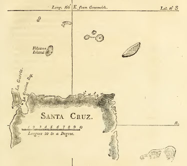
The Island signified by the letter a in Mr. Wilson′s log and in the above sketch, was supposed to be the Swallow′s Island of Captain Carteret′s chart; but there is cause for doubt. According to the situation given to Swallow′s Island, with respect to Santa Cruz Island, the Missionary ship could not have missed seeing it; for in fact her track passes over
VOL. II. A A
[page] 178
SANTA CRUZ Islands.
the Northern part of the space assigned to Swallow′s Island in Carteret′s chart. Swallow′s Island however is represented to be 10 leagues in extent from NE to SW, whereas the greatest extent that was seen of the Island a (which was likewise in a NE and SW direction) does not exceed a league and a half. Swallow′s Island is also laid down farther East from the Volcano than a is. Captain Carteret describes Swallow′s Island to be a long flat Island, and has placed it from 8 to 15 leagues distant from the nearest part of his track. If the Island is low as well as flat, which most probably is the case, he has placed it much too far North; for Islands of that description are seldom seen beyond the distance of 5 or 6 leagues. The disproportion of size between Swallow′s Island in the chart, and the Island a seen in the Duff, is too great for admitting them to be the same Island.
The latitude of the Volcano computed from the track of the Duff, is 5 miles more South than in Captain Carteret′s chart. The noon observation of the Duff on the 27th was esteemed but indifferent. Taking the mean between Captain Carteret′s and Mr. Wilson′s latitudes, will give for the middle of the Volcano Island 10° 21′ S.
In the plan of the Santa Cruz Islands accompanying these remarks, as much as is laid down of Santa Cruz, is reduced from Captain Carteret′s chart, with an alteration of about 2 miles in the latitude to preserve its situation with respect to Volcano Island. The land of Santa Cruz, which was seen by the Duff, was only a part of the North coast Eastward of the Volcano, and her distance was too great to settle or even to know any particular point of land. The extent given by Captain Carteret to the North coast of Santa Cruz is less than a degree in longitude; its extent Southward therefore must be supposed considerable to correspond with the Spanish accounts, which describe the Island to be 90 or 100 Spanish leagues in circuit. The Southern part is left blank for want of materials. When
6
[page] 179
the Voyage of M. D′Entrecasteaux shall be published, a correct, chart of the whole of the Island Santa Cruz may be expected.
The land to the SE is represented by Captain Carteret as two Islands; but the Spanish accounts speak of it as a single Island.
The Swallow′s Island of Carteret is placed more to the South, and consequently with less extent than it appears in his chart. The small Islands to the Northward of Santa Cruz are laid down according to the remarks in the log-book of the Duff.
Island in 6° N latitude.
The Island in ′full 6° N′ [′largos′ for which 1 o′ may very well be allowed] was discovered in a direct course between two described but not exactly specified stations. One of these stations is in 11° S latitude, distant from the West part of the Island Santa Cruz, a day and a half′s sailing with a light wind. The other station is in 14° N, and Eastward of the Island Guahan, the distance of two day′s sailing with a fresh wind. With such guidance, and within so limited a compass, conjecture cannot stray very wide of the mark. Allowing 30 leagues West from Santa Cruz for a day and a half with a light wind, and 80 leagues East from Guahan for two day′s sailing with a fresh wind, a line drawn from one to the other of those stations will cross the parallel of 6° 10′ N, nearly in 154° East a Greenwich.
Another method of computation would be to reckon back from the ladrones, Eastward 80 leagues in the parallel of 14° N, and from thence in a SSE direction to latitude 6° 10′ N; but against this last method is to be objected the want of knowledge concerning the variation of the compass. For the situation of the Island therefore may be taken latitude 6° 10′ N, and longitude 154° E a Greenwich.
A A 2
[page] 180
Perplexity created respecting the SALOMON ISLANDS.
The second voyage of Alvaro de Mendana has been entitled a Voyage for the Discovery of the Salomon Islands,* which perhaps may be defended by the intention of the undertaking; but this title, when compared with the fact, has a whimsical appearance. In this second voyage, the Salomon Islands were sought for far beyond where report had placed their discovery; and the voyage having concluded without their being found, has afforded occasion to remark, that what Mendana discovered in his First Voyage, he lost in his Second†.
Quiros applies in Peru for fresh Ships.
Arguments used by him.
Pedro Fernandez de Quiros, upon his return to Lima, made application to the Viceroy to be furnished with ships and people to prosecute the enterprise began by Mendana, and to make more discoveries of unknown lands. He presented to the Viceroy two Memorials on these subjects, the substance of which Figueroa has given‡. The arguments used by Quiros are diffuse and sometimes quaint, but they appear to be the result of reflection. He remarks, that the natives of the Islands in the South Sea, having no knowledge of the compass nor any instrument of navigation but their eyes, would not undertake Voyages of greater length than they were enabled with safety to do by obtaining sight of other land before or as soon as they ventured beyond the sight of the land they departed from; for though it is not difficult to find the way to a large land, where
* Relacion del Viage al descubrimiento de las Islas de Salomon, is the title given by de Morga to the letter of Quiros.
† The variety of conjectures afterwards made concerning the situation of the Salomon Islands, with the scarceness of the copies of the Spanish accounts, contributed to increase the perplexity concerning them till they were again found, 200 years after the first discovery.
‡ Ilechos de 4me. Marq. de Canete, p. 286-290.
[page] 181
the distance is not great, yet it is not to be admitted that without science they could seek small or distant lands. From hence, he infers, either, that the Islands which have been discovered inhabited in the South Sea are connected by others which are so many links of the same chain extending quite across that sea, or that towards the South there existed a continent extending from New Guinea towards the Strait of Magalhanes, as otherwise the Islands could not have been peopled without a miracle. In support of his argument he observes, that not any of the Islands which have been discovered in other parts of the world at a great distance from all other land, were found with inhabitants, but all desert and waste. For example, in the ATLANTIC, the Azores, Madeira, and the Cape de Verd Islands, which, being far in the sea, were without people when first discovered; whereas the Canary Islands, being near the continent, were inhabited. He remarks likewise, as evidence of communication between different Islands in the South Sea, that people differing in colour were sometimes found to inhabit the same Island. From all these considerations Quiros concluded that many large countries still remained to be discovered.
He is sent to Spain.
The Viceroy Don Luys de Velasco, who had recently been removed from the government of Mexico to succeed the Marquis de Caete in Peru, approved the reasonings of Quiros, but did not think proper to grant his demands without orders from the King to that effect: he therefore sent him to Spain with letters recommending his proposals to his Majesty and the Spanish ministers.
[page] 182
CHAP. XI.
The Ship San Agustin wrecked on the Western coast of North America. Expedition of Sebastian Vizcaino to California.
CHAP. 11.
1595.
Wreck of the San Agustin.
THE government of New Spain, in consequence of orders received from the King, had at this time resumed the intention of forming an establishment on the American coast to the North of California, for the convenience of the navigation from the Philippine Islands. In 1595, a ship named the San Agustin, acting under directions given by the Viceroy, Don Luys de Velasco, in her return towards New Spain from the Philippines, undertook the examination of the Northern coast in search of a harbour. She discovered the port which has since been named de San Francisco, ′and being already within this ′port, a squall of wind drove her on shore, and she was there ′wrecked.′* Her people, or some of them, as appears by subsequent circumstances, found means to convey themselves to New Spain.
1596. Vizcaino sails for California.
In 1596, the Conde de Monterey, being Viceroy of Mexico, received instructions from Spain to send ships to examine the coasts and discover the harbours of California. For this service three vessels were equipped, which sailed from Acapulco, under the command of Sebastian Vizcaino, at what time of the year is not mentioned†, but it was not at a late season. They proceeded along the coast towards the NW, as far as to the Isles of Mazatlan, where they stopped to take in fresh water. Above 50 of the people who had embarked with Vizcaino deserted at
* Monarquia Indiana, por F. Juan de Torquemada, lib. 5, cap. 55.
† The account of this expedition is given in the Monarquia Indiana, lib. 5. cap. 41, 42.
[page] 183
1596.
this place, because it appeared to them that the vessels were not sufficiently provided with provisions and stores for their undertaking, one purpose of which was to form a settlement in California.
settlement formed at Puerto de Cortes, or B. de la Paz.
From Mazatlan, the vessels sailed across the entrance of the gulf to the Bay de Santa Cruz in California, and the same place formerly chosen by the Marquis del Valle for his colony, which was known by many remaining signs, was now fixed on by Sebastian Vizcaino for the site of a town; and as the natives there appeared of a peaceable disposition, he named the port Bahia de la Paz (the Bay of Peace); but in some of the charts since that time, the name of Puerto de Cortes has been retained.
Almiranta and Launch sent within the Gulf.
Vizcaino remained in port to superintend the business of the new settlement, and sent the Almiranta (the second ship) and a launch to examine the Californian shore within the gulf. They found the sea near the coast shoal, but well furnished with fish, particularly with pearl oysters, the shells of which were so bright, that ′at 3 or 4 fathoms depth, they were seen as clear as if they had been on the surface of the water.′ The country was populous. At some places, the Spaniards were received with marks of friendship; at others, the natives made threatening signs with their bows and arrows to deter them from approaching.
About 50 leagues from Puerto de Cortes, fifty men were landed from the Almiranta and the launch, at a place where the natives were not disposed to admit their visit peaceably, but shot arrows at them. The Spaniards in return, fired their muskets, and two or three of the natives fell, upon which the rest, retreated. The Spaniards soon after began to embark, but their boat was not large enough to carry more than half their number at one time; therefore one half was left on shore to wait for the return of the boat. In this interval of time, many hundreds of the natives
[page] 184
1596.
Boat attacked by the Natives.
collected near the spot, and kept themselves concealed, waiting for an opportunity to take their revenge, whilst the Spaniards believed that their terror at what had already passed, kept them at a distance. When the boat arrived the second time, and the embarcation was just compleated, the natives poured forth from their concealment, and shot a flight of arrows so thick and unexpectedly upon the Spaniards, who were much crowded together, that, with the disorder and agitation occasioned by the surprise, the boat overset. Nineteen Spaniards were killed by the natives or drowned; the rest escaped to the ship by swimming, but every one wounded. The natives got possession of the arms and clothes of the dead men, and in exultation at their victory, decked themselves in the spoils, and danced in sight of the ship.
The Almiranta and launch were a month absent on this excursion, and went about 100 leagues within the gulf. When they rejoined the General, the stock of provisions remaining was judged to be too small, though assisted with game, fruits, and fish, with which the country and coasts abounded, to admit of their continuance in their new town; and, as if to hasten their determination, one of the houses of the settlement took fire, which communicating to the rest, the whole, being of wood, were consumed.
This happened when the settlement was only two months old. The native inhabitants in this part of California had been found exceedingly gentle and docile. They brought fruits and fish to the Spanish priests, who had begun to instruct them in the Christian faith, and encouraged them to bring their children to be instructed: they attended at mass, and joined in many of the observances: ′but they avoided the soldiers as much as they were able, because they used to take from them by force what-soever they had. They wished to have persuaded the priests to remain with them, but were glad to have the soldiers go.′
2
[page] 185
1596. October. The Settlement abandoned.
In October, Vizcaino embarked with all his people, and they returned to New Spain.
This was the laft maritime expedition in the South Sea undertaken by the command of Philip II.
As the efforts of the Spaniards in this ill appointed expedition were directed to the coast of California within the gulf, it must have been intended only as an intermediate and preparatory step to the forming an establishment on the exterior coast. Nothing farther towards the accomplishment of this purpose was immediately undertaken; and the appearance of a new enemy in the Pacific Ocean, with the accession of a new Sovereign to the Spanish monarchy, both of which events happened shortly after Vizcaino′s return from California, occasioned all plans for further discovery to lie dormant for some years.
VOL. II. B B
[page 186]
CHAP. XII.
Voyage of Five Ships of Rotterdam, under the command of Jacob Mahu, and Simon de Cordes, to the South Sea.
CHAP. 12.
1598.
IN 1598, the King of Spain, Philip the IId. surnamed the Prudent, died, and was succeeded by his son, Philip the IIId.
The inhabitants of the United Provinces of the Low Countries had at this time embarked deeply in adventures to the East Indies. In each of the years, 1594, 1595, and 1596, they had employed ships* in the difficult and dangerous attempt of endeavouring to discover a passage to China by the North and East of Europe and Asia. The firft voyage actually performed by the Dutch to the East Indies, was by ships which sailed from Holland in April 1595, and went the usual, or rather what might then be called the Portuguese, route; i. e. round the Cape of Good Hope. In 1598, a large fleet sailed from Holland for the East Indies, which likewise went by the Cape of Good Hope; and so eager were the Hollanders to increase their connections in that part of the world, that two other expeditions for the East Indies were undertaken by them the same year, with fleets of less magnitude, which were directed to sail a Western route, through the Strait of Magalhanes, and across the South Sea.
The first which departed of the two expeditions bound for the Western passage, were five ships of Rotterdam, fitted out at the charge of some merchants who were called the Company of
* Conducted by William Barentz.
[page] 187
1598.
Pieter Verhagen. The particulars which are known of this voyage are here collected from separate accounts, which were published at different periods and in different languages*.
Equipment.
The ships were, the Hope †, of 500 tons (250 onera), and 130 men, commanded by Jacob Mahu, who was Admiral or General of the fleet; in which ship William Adams, an Englishman, sailed as pilot; the Charity, of 300 tons and 110 men, Simon de Cordes, Vice Admiral; the Faith, 320 tons and 109 men, commanded by Gerard Van Beuningen; the Fidelity, 220 tons and 86 men, J. Van Bockholt; and the Good News, a yacht of 150 tons and 56 men, commanded by Sebald de Weert. These vessels were furnished both for war and for trade, and one part of the plan of their expedition was to
* A journal was written in the German language by Mr. Bernard Jansz, who went surgeon in one of the ships. His account in the latter part is entirely limited to the adventures of the ship in which he sailed. A Latin translation of the Journal of Jansz was published by the sons of Theodore de Bry, in 1602; and from that translation it has been re-translated and published in different languages. It is given in the Recueil des Voyages a l′Etablissement de la Comp. des Ind. Orient, with the title of a Voyage of Five Ships of Rotterdam; but in propriety should have been called the voyage of Sebald de Weert. Other voyages in the same collection furnish particulars concerning this.
A more general, but very brief, account of the voyage of the five ships, is given in the Recueil des Navigations de l′Etroit de Magellan, printed at Amsterdam, 1622, with Herrera′s Descrip. des Ind. Occid.
In Purchas, Vol. I. Book 3, are inserted two letters, written by William Adams, who sailed chief Pilot of the Rotterdam fleet; and in Vol. V. p. 588, is a farther account of Adams. These contain certain circumstances of the voyage which are not noticed in any of the before-mentioned accounts.
† The names of the ships have undergone translation into every language in which any account of the voyage has been published. A frontispiece to the voyage in De Bry, has in it five ships under sail, to which are affixed the names in the German language, which it is probable were the names used by the journalist Bernard Jansz. Not having met with any relation in the Dutch language by which the real names could be ascertained, the English have been taken for the present account.
B B 2
[page] 188
1598.
visit the Spanish settlements ou the coast of Chili and Peru, in the hopes that some good booty would be obtained before they crossed the Pacific Ocean.
June. Departure from Holland.
September. Jacob Mahu dies.
De Cordes succeeds.
This fleet sailed from Goree (in Holland) June the 27th 1598, but contrary winds and other causes of delay, so much retarded their progress, that at the end of August they had only reached the Cape de Verd Islands, among which they stopped some time. From these Islands they sailed for the coast of Guinea; and in this passage, on the 23d of September, Jacob Mahu, the General, died. Simon de Cordes, according to directions given by their employers, succeeded to the chief command, and Van Beuningen was appointed Vice Admiral. By the removals which took place among the commanders, Sebald de Weert became Captain of the Faith, and Dirck Gherritz was made Captain of the Yacht. They afterwards stopped both on the coast of Guinea, and at the Island Annobon. The object of the Hollanders in these stoppages was to obtain provisions and refreshments; but from their enmity with the Portuguese at some places, and the poverty or distrust of the natives at others, their success was very moderate.
1599.
January the 2d, 1599, they sailed from Annobon for the American coast. At this time they had lost 30 of their men, principally by the scurvy.
On March the 12th, at which time they were near the entrance of Rio de la Plata, the sea was observed to appear as red as blood. Some of the sea water was examined, ′and found to be full of little red insects, like worms, which, on being taken into the hand, jumped about like fleas. Some were of opinion, that at certain seasons of the year, the whales shake these worms from off their bodies; but of this they have no certainty.′*
* Rec. des Voy. de la Comp. des Ind. Orient. Vol. II. p. 296. Rouen, 1725.
[page] 189
1599.
April.
In the Strait of Magalhanes.
April the 6th, the fleet entered the Strait of Magalhanes, and towards evening on that day, anchored near the smallest of ′the two Penguin Islands, 14 leagues within the entrance.′*
On the 9th, they advanced farther within the Strait, anchoring occasionally. The 17th, they sailed between two high shores, which, says the journal, seemed to meet and close up the passage; and the following day they put into a bay on the North side of the Strait, which was named the Great Bay, afterwards Green Bay; and lastly, the Bay de Cordes. ′In the middle of this bay there are three small Islands, the most Eastern of which is the smallest.′†
The winter had begun, and De Cordes ought to have made every possible exertion to pass speedily through the Strait: but he was in an extraordinary degree negligent. For several days after the ships entered the Strait, the winds were from the East and North East; and until the 20th of the month, they had winds favourable for proceeding, ′with which it only rested with themselves to pass through,′‡ This opportunity was suffered to escape: more time than was necessary was expended in making provision of wood and water, and likewise in setting up a shallop, a business which should have been deferred to a milder latitude and season.
After the 20th, the winds set in from the Westward, and the fleet remained in the Bay de Cordes till near the end of August. They were not detained in that port so long by the winds; but by the unwillingness of the General to put to sea during the
* These are the first small islands within the Angostura de San Simon.
† Voy. a l′elabl. de la Comp. Vol. II. p, 298. The situation given to the Bay de Cordes in a Chart of the Strait published with the voyage of Spilbergen, corresponds nearest with the present Port Galant; but there is only one Island at Port Galant. The Bay next to the East, which Commodore Byron calls Cordes Bay, and the Spanish Chart Gaston Bay, approaches nearer to the description given above, but does not exactly accord with it.
‡ Voyage de cinq. Balleaux, in Rec. des Nav. de l′Etroit.
[page] 190
1599.
April. In the Strait of Magalhanes
winter. William Adams, the pilot, says, ′many times in the winter we had the wind good to go through the Strait, but our General would not.′* The winter was accordingly passed in Cordes Bay, and proved extremely severe. Gales of wind followed each other in quick succession, which made the ships drag their anchors, and damaged their cables so much, that they were kept in continual anxiety and labour to provide for their security. Scarcity of food and raiment were among the miseries they had to endure: the former of these wants made it necessary for the people to be sent on shore every day at low water, frequently in rain, snow, or frost, to seek along the shore for shell fish, and to gather roots for their subsistence. Their necessities and the sharpness of the weather ′seemed to render their stomachs insatiable. The shell fish, roots, or whatsoever eatable they could pick up, they devoured in the state they were found, having no patience to wait till they could be cooked.′ The journal says, ′they found here abundance of muscles, of which it has been said that some were a span in length, and when cooked, the flesh of three of the largest weighed a full pound.′†
There grew round the bay a great number of ′trees which resembled the laurel, but were much taller; the bark was more bitter, and had a taste as strong as that of pepper.′‡ Some natives were seen who were of large stature. They were not disposed to be friendly with the Hollanders, but attacked them twice, by which three Hollanders and four or five natives′ lost their lives.
The hardships suffered during their stay in this place, occasioned great mortality among the crews of the ships, insomuch
* Letter of W. Adams. Purchas, Vol. I. Book 3, p. 130.
† Rec. des Voy. de la Camp. Vol. II. p. 298.
‡ Ibid.
[page] 191
that they buried above 120 men here, and among them Captain Bo kholt, who was succeeded in the command of the Fidelity by Balthasar de Cordes.
1599.
In the Strait of Magalhanes August.
On the 2d of August, the General, whose compassion seems not to have kept pace with his piety, ordered the companies of all the ships on shore, and during an extreme heavy snow, made them attend to a sermon of thanksgiving.
It was to perpetuate the memory of their sufferings at this place and of their companions deceased, that the name of the Bay was changed to that of De Cordes.
August the 23d, they quitted the Bay de Cordes with a wind from the NE. The next morning it fell calm, and they anchored in a bay of the South shore. Whilst they lay here, the General created an order of Knighthood, to the honours of which only the six principal officers of the fleet were admitted. They engaged themselves, by oath, freely to expose their lives upon all occasions against the enemies of their country, and particularly ′to exert their utmost efforts to render the arms of Holland triumphant in the country from whence the King of Spain drew those treasures which he had employed so many years to the oppression of the Low Countries.′
The ceremony of installation was performed on shore. The order was named, of the Lion Unchained, and the Bay in which this passed was named the Bay of Chevaliers. It may be observed, that the proofs afterwards given by the Hollanders in the South Sea, of zeal for their own country and of enmity against the Spaniards, did not derogate from this engagement.
September. The fleet enter the South Sea.
September the 2d, the wind sprung up afresh from the Eastward, and they again set sail. On the evening of the 3d, the whole fleet (six in number, reckoning a shallop of 16 tons, named the Postillion, which had been set up in the Strait) entered the South Sea. The three following days they sailed on a WbN course; the wind then became unsteady, and the sea
[page] 192
1599.
September.
turbulent. On the 7th, by a sudden gust of wind, the yacht received some damage in her foremast, which obliged her to take in all her sails, and she fired a gun to give notice of her distress. The nearest vessels immediately went to her assistance, and others took in sail to wait for her; but the Admiral, being far ahead, and the weather hazy, did not perceive what had happened to the yacht, and a thick fog coming on, he continued to sail on as before, by which means he was separated from his fleet whilst he supposed they were following him.
Are separated.
On the 10th, the wind blew fresh from the NW, and in the night, by some mistake or omission of making signals, the rest of the ships were almost entirely separated from each other, and so few of them joined company again, that the sequel of their adventures requires to be severally traced.
The ships had been appointed to rendezvous, in case of separation, first on the coast of Chili in latitude 46°, where they were to wait a month, and if not then joined by the Admiral, they were to proceed Northward to the Island Santa Maria. Accordingly, Simon de Cordes, in the Hope, after he missed his fleet; endeavoured to make the coast of Chili.
Course pursued by the Admiral.
Some account of the proceedings and adventures of the two ships, the Hope and Charity, after the separation of the fleet, is given in the Recueil des Navigations de l′Estroit de Magellan, and in the letters of the pilot, William Adams. The account by Adams is most full of circumstance, but some of his dates have been erroneously printed, as they disagree not only with other accounts, but with each other. He appears likewise to have made use of the word Admiral in the same sense as the Spanish word Almiranta, meaning the Vice Admiral, or second in command; which being so undertsood, reconciles his account with that in the Recueil, and with his being himself embarked in the ship of the chief commander. Adams relates,
8
[page] 193
1599.
′The 24th of August we came into the South Sea; where, six or seven days after, we lost the whole fleet one from another. The storm being long, we were driven to 54½° S latitude. The weather breaking up, and having good wind again, the 9th of October* we saw the [Vice] Admiral, of which we were glad. Eight or ten days after, in the night, having much wind, our foresail flew way, and we lost company of the [Vice] Admiral. Then, according to wind and weather, we directed our course for the coast of Chili; where, the 29th of October, we came to a place in 46°, where we staid 28 days.†— Here we refreshed ourselves, finding the people of the country good of nature. They brought us sheep and potatoes, for which we gave them bells and knives; but in the end the people went up from their houses into the country, and came no more.′‡ From this place, De Cordes sailed for the Island Santa Maria. Early in November, he anchored near a point of the main land opposite to that Island, and landed with twenty-three of his men to endeavour to obtain provisions; but they were treacherously attacked by the natives, and all killed. Among them was Thomas Adams, brother to the pilot. At the Island Santa Maria, the Hope joined the Charity, which ship had arrived there four days before, and the companies of the two ships had to condole with each other on their mutual misfortunes, the Charity having stopped at the Island Mocha, where the Vice Admiral and 27 of his men were cut off.
Stops on the Coast of Chili.
Sails for Santa Maria November.
Death of De Cordes;
and of the Vice Admiral.
Island Santa Maria
The attack by the Indians on the main land, was believed by the Hollanders to have been made at the instigation, and under
* By the sequel it is evident, that here and in the date which next follows, the month September was intended, and not October.
† Second letter of W. Adams. Purchas, Vol. I. Book 3. c.1. § 5.
‡ First letter of IV. Adams. Ibid.
VOL. II. C C
[page] 194
1599
November.
Island Sauta Marie
the direction of the Spaniards. And whilst the ships lay at Santa Maria, a message was brought from a Spaniard requesting permission for him to visit the ships, which was granted; but he did not go on board without some security or promise being first given that he should not be detained. He made a second visit, using the same precaution, and departed both these times at his own pleasure without interruption. ′The third time,′ Adams relates, ′came two Spaniards on board us without pawne; and when they had seen the ship, they would have gone on land again, but we would not let them, shewing that they came without leave. ′The release of the Spaniards was obtained at the price of some sheep and beeves.
They waited at Santa Maria a proper time for the other ships, but none arrived to join them. It was proposed, as the companies of the ships had been so much weakened, that the men and stores should all be embarked in one ship, and the other be abandoned and burnt: but the new commanders could not agree which of the ships should be burnt, and therefore both were kept. Their strength, however, was not sufficient for them to venture at any enterprize against the Spanish settlements in Peru, and they determined to leave the coast of America ′and direct their course to Japan′ to trade, as they had on board woollen cloths which were supposed to be in good estimation in that country.
The Hope and the Charity sail for Japan.
Islands in 16° N.
November the 27th *, the two ships, the Hope and the Charity, with a pinnace that had been set up, sailed from the Island Santa Maria. Adams writes, ′we took our course direct for Japan, and passed the line equinoctial with a fair wind, which continued divers months. In our way, we fell in with certain Islands in 16 degrees North, the inhabitants of which
* Both the letters of Adams give this date to the time of their quitting the American coast.
[page] 195
1599.
′are men eaters.′* At these Islands, the pinnace, with eight men in her, being at a distance from the ships, was attacked and taken by the Islanders.
1600.
February.
Between the latitude of 27° and 28° N, they had variable winds. In the night of February the 22d (l600) the two ships lost sight of each other†, and they did not meet again.
March.
An Island.
Las Coluñas.
The ship in which Adams sailed (of the other there is no farther account) continued her course for Japan. March the 24th, they saw an Island which Adams calls Una Colonna, on the authority, doubtless, of Spanish charts which place three Islands with the name of las Colunas (the Columns) in latitude from 27½° N, to 29½N, and about 31° of longitude to the East of the Embocadero de San Bernardino.‡ Islands thus situated must have been discovered early after the navigation from the Philip-pine Islands to New Spain was established, and it is probable that many discoveries in this navigation were never otherwise made
* Second letter of W. Adams. Nothing farther is said of the situation of these Islands: the dale is not given, nor can it he inferred from any thing subsequent. Islands with the name of Gaspar Rico are laid down in the Spanish charts of the Pacific Ocean, and in some tables, between the 15th and 16th degrees of North latitude, and about 46 degrees East from the Embocadero de San Bernardino; and no other lands appear in the charts between New Spain and the Ladrones that will in any degree correspond in situation with the Islands seen in this passage by the Dutch ships.
The date of the discovery of the Islands Gaspar Rico, or on what authority they are laid clown in the Spanish charts has not been met with. The name of Jaspar Rico appears among the pilots who sailed with Ruy Lopez de Villalobos; but neither in the navigation of Villalobos, nor of the ship San Juan, which twice attempted the passage from the Philippine Islands to New Spain, were any Islands discovered near the situation in which the Gaspar Rico Islands are laid down, and which is not in the track of ships from the Philippines to New Spain. Herrera has not noticed them either in his description of the Indies, or in his charts.
† In the Description du Penible Voyage, par Ol. de Noort, it is said, but on report only, that one of the ships was abandoned, p. 52. Edit. 1602. Amsterdam.
‡ Las Colunas are set down, in a table of latitudes and longitudes printed at Manila, in latitude 27° 57′ N, and longitude from the Emboc. de S. Bernardino 31° 10′ E. Navegacion Especulativa y pratica, por Jos. Gonz. Cabrera Bueno, Manila, 1734.
C C 2
[page] 196
public than by marking the Islands on the charts, and entering them in the Geographical tables. *
1600.
April.
One ship arrives at Japan.
April the 19th, they made the coast of Japan in latitude 32½°N, and anchored near Bungo, which is in one of the SW of the Japan Islands. The number of men then on board were twenty-four, of whom seventeen were sick.
The Japanese at Bungo gave them assistance, but at the same time plundered the ship, which the Hollanders attributed to the Portuguese who were in Japan having represented them to be pirates. The Emperor of Japan afterwards gave orders that their effects should be restored; and as many of the things were irrecoverably dispersed, he directed 50,000 reales† to be distributed among the sufferers. He would not, however, allow the ship to depart, but provision was made for her people. ‡
William Adams, the pilot, was ordered to be sent to the Emperor at Osaca§, and was carried thither in one of the Emperor′s gallies. He estimated the distance from Bango to be about 80 leagues. The ship was afterwards removed near to Osaca. Adams has related in his letters some of his adventures in Japan, and there is no mixture of any thing improbable in his narrative: the following extract therefore is given.
William Adams at Japan.
Coming before the King, he viewed me well, and seemed to be wonderful favourable.—There came one that could speak Portuguese; by him the King demanded of what land I was, and what moved us to come to his land, being so far off. He asked me divers other questions, as, what way we came to
* In the Navegacion Especulativa, the Gaspar Rico Islands are entered in the list of places which lie in the track from Acapulco to the Philippines: and the Columnas in the track from the Philippines to Acapulco.
† The real at that time was in value nearly 6d. sterling.
‡ This was the commencement of the Dutch intercourse with the Japanese. M. de Brosses remarks (Nav. aux Terres Australes, Vol. I. p. 294) that in this accidental manner was laid the foundation of that exclusive commerce afterwards established in favour of the Dutch, on the ruins of the Portuguese interest at Japan.
§ Second letter of IV. Adams.
[page] 197
W. Adams at Japan.
′his country. Having a chart of the whole world, I shewed him through the Straits of Magellan, at which he wondered, and thought me to lie. Then, from one thing and another, I abode with him till midnight. Two days after, he sent for me again, and enquired of the qualities and conditions of our country, of wars and peace, of the beasts and cattle; and it seemed he was well content with my answers to his demands.
′In process of four or five years, the Emperor called me, as he had done divers times before; so one time he would have me to make him a small ship: I answered, that I was no carpenter, and had no knowledge thereof. Well, do it so well as you can, saith he, if it be not good, it is no matter. Wherefore at his command I built him a ship of the burthen of 80 tons, or thereabouts; which ship being made in all proportions as our manner is, he coming on board to see it, liked it very well; by which means I came in more favour with him, so that I came often in his presence, who from time to time gave me presents, and at length a yearly revenue to live upon, about 70 ducats by the year, with two pounds of rice a day also. Now being in such grace and favour, by reason I learned him some points of Geometry, and the Mathematics, with other things, I pleased him so well, that what I said could not be contradicted.′—′In the end of five years I made supplication to the King to go out of this land, desiring to see my poor wife and children, according to conscience and nature. With this request the Emperor was not well pleased, and would not let me go.—′
The Emperor′s will in this particular did not alter, and Adams lived the remainder of his days at Japan, though others of the same company had leave to depart, and were permitted to build themselves a vessel for that purpose.* Some of the seamen of
* Penible Voyage de Oliv. de Noort, p. 52.
[page] 198
W. Adams at Japan.
the Hope voluntarily entered into the service of the Emperor of Japan. William Adams afterwards built another ship, increased in favour, and received from the Emperor a grant of lauds ′with 80 or 90 husbandmen.′ He had sometimes the satisfaction to see some of his countrymen, and found opportunities to send letters to England.*
1599. The Yacht., D. Gherritz discovers land in 64°S.
The yacht commanded by Dirck Gherritz, was separated from all the other ships, and ′was carried by tempestuous weather to the South of the Strait, to 64° S latitude, where they discovered a high country, with mountains, which were covered with snow like the land of Norway.′† Gherritz afterwards sailed to the coast of Chili, in hopes that he should there rejoin some of the fleet; but he missed the Island Santa Maria, and was taken by the Spaniards at Valparaiso.‡
The Fidelity and the Faith put back into the Strait.
The Fidelity and the Faith did not part company from each other in the dispersion of the fleet. On the 26th of September, they found themselves near the Western entrance of the Strait of Magalhanes; and the wind blowing strong from the West, they were forced the next day to run back into the Strait for shelter. They remained at anchor near the Western entrance till December the 2d, when, having a wind from the NE, they got under sail, purposing again to enter the South Sea; but the Faith could not with that wind be got clear of the bay in which they had anchored, which they named Close Bay. The next day however, they left Close Bay, but the wind was not then
* The first letter from William Adams is dated October 22d, 1611; the second is without date. At the end of the letters, Purchas informs his readers that William Adams aied at Firando, intelligence of which event was brought by a ship named the James, which returned from India in the year 1621. A large account of William Adams is given in Harris′s Collection of Voyages, Vol. I. p. 856 & seq.
† Rec. des Navig. de l′Estroit de Mag. p.193.
‡ Descrip. du Penible Voyage, par Ol, Van Noort, p.26. Likewise Rec. a l′etabl. de la Comp. Vol. III. p.60.
[page] 199
1599.
The Fidelity again enters the South Sea.
fair for quitting the Strait, and by some accident or difference of management, the two ships anchored a league apart, having a point of land between which intercepted from them the sight of each other. The 8th, a gale of wind (which must have been from the Eastward) forced the Fidelity from her anchors, and she was afterwards driven out of the Strait into the South Sea. Her departure was not known on board the Faith till after the gale.
And sails to the Moluccas.
Captain Balthasar de Cordes, in the Fidelity, sailed to the coast of Chili, but did not meet any of the other ships of the fleet. He ran afterwards along the coast of Peru, and captured some Spanish vessels. From thence he sailed across the South Sea to the Moluccas; but no particulars are given concerning his track in that passage. At the Moluccas the Fidelity was taken by the Portuguese.*
The Faith, S.de Weert.
Strait of Magalhaue
The Faith, commanded by Sebald de Weert, being left in the Strait without a consort, her crew, who were before discontented, showed themselves wholly averse from proceeding. De Weert, the journal says, made exhortations to them to persevere in their duty; but he was content to act according to their inclinations.
Natives met with.
December the 12th (1599), some of the people of the Faith were sent with a boat to search for provisions. On going round a point of land, they discovered three canoes with natives in them, who, immediately on seeing the boat, landed as speedily as they could and fled to the hills. The Hollanders examined the canoes, in which were some penguins, some small skins, and fishing implements. They then landed, and going in search of the natives, at the foot of a mountain overtook a woman who
* Rec. des Navig. de l′Estroit de Magellan, p.193.
[page] 200
1599.
December.
Sebald de Weert.
Strait of Magalhanes
was making her utmost efforts to escape, but in vain, as she had with her two children, one of them too young to walk, and was by her appearance then far advanced in pregnancy. This poor creature and her children were made prisoners, and with one of the canoes were taken to the ship. To form a judgment from the terms in which the journalist has related this circumstance, it would appear that her situation excited neither compassion nor interest, and that she was regarded by those on board the ship only as a diverting curiosity. But in this ill placed attempt at ludicrous description, there are several circumstances which must awaken serious reflection. She was of moderate stature; her colour was that of copper; her hair was cut short; her nails were long; her legs were bent, which may be attributed to their mode of sitting; and her mouth was wide, which was probably an individual peculiarity. Her dress was the skin of a sea animal which hung over her shoulders, and a necklace of periwinkle shells. When she was taken and carried to the ship, no signs of lamentation appeared in her countenance, nor was any emotion observable, except that she had an air of fierceness. She refused to eat victuals cooked in the European manner; therefore some of the birds found in the canoes were given to her, which she prepared for herself and her children, using a muscle shell for a knife, with which she cut them open, and cleared them of the entrails. Some parts she distributed raw, and others she just warmed on the fire.
The eldest of the children was a girl about four years of age, the other an infant about fix months old: in partaking of this food, they all tore it in pieces with their hands and teeth. Their eating was a spectacle which afforded great entertainment to the ship′s crew; and it was thought strange, whilst they occasioned so much merriment to others, that themselves remained serious. The journalist remarks with some surprise, that ′the woman
8
[page] 201
1599.
December.
Sebald de Weert.
Strait of Magalhanes
′during her meal, never made the least smile, notwithstanding that the seamen burst into frequent shouts of laughter.′*
The poor woman had to endure this state of persecution two days, which time she remained the object of their foolish wonder and mirth. The Captain then ordered her to be set on shore, and gave her a cloak, a cap, and some beads. The younger child was likewise dressed with a green habit, and sent with her; but the girl was kept in the ship to be taken to Amflerdam. The mother expressed by her looks, her distress and anger at being robbed of her child, but seemed to think complaint useless, and in silent resignation left the ship with the child which she was allowed to retain.
December the 15th, the Faith sailed Eastward for the Bay de Cordes, keeping a good look-out for the Fidelity, which ship they yet hoped to find within the Strait. In this short passage, they towed their boat astern, the only one they had remaining; but in a sudden fresh of wind, which forced the ship very fast through the water, the tow rope broke and the boat went adrift, and was not recovered again.
Dc Weert meets the Fleet of Olivier Van Noort.
When they were near the Bay de Cordes, they fired a gun for the chance of the Fidelity being within hearing, and some on board thought that they heard the report of a cannon in answer to theirs. The same evening they anchored in de Cordes Bay; and the next morning they saw a boat rowing towards them from the Eastward *, which was supposed to belong either to the Fidelity or to one of the other ships of their fleet. But on her arrival, she was found to belong to another fleet of their countrymen, which had sailed from Holland under the command of
* Rec. a l′Etabl. de la Comp. Vol. II. p.321.
† The Recueil des Voyages de la Comp. says, from the Westward; but in the Penible Voyage, it is from the Eastward, which agrees with the Charts to the early Dutch Voyages.
VOL. II. D D
[page] 202
1599.
December.
Sebald de Weert. Strait of Magalhanes
Olivier Van Noort, bound for the South Sea and the East Indies.
Parts from Van Noort.
On the morning of the 20th, Van Noort, with his ships, sailed Westward in prosecution of their voyage, with a breeze from the ENE, and De Weert sailed in company with them. In the afternoon the wind changed and became unfavourable, and De Weert′s ship could not keep up with the others. Van Noort continued to make progress Westward, though but slowly; and by the 24th, De Weert was left out of sight. There remained at this time on board the Faith only 38 men, she having lost nearly two-thirds of her ship′s company since her departure from Holland; which accounts for her helpless condition.
1600. January.
Again left to themselves, De Weert returned to the Bay de Cordes, where he set together the frame of a boat which they had brought in pieces from Holland. On the 1ft of January, 1600, two boats arrived in the Bay, in one of which was the commander Olivier Van Noort, whose ships had not been able to advance farther than the Bay des Chevaliers. He returned the next day to his ships. De Weert afterwards, when his boat was compleated, sent to request of Van Noort a supply of biscuit, but did not obtain any.
The Penguin Islands.
Patagonian Woman.
January the 11th, the Faith sailed from Cordes Bay for the Penguin Islands near the Eastern entrance of the Strait, and the next day anchored at the smallest of the two Islands, from which they took and salted penguins. Some of the seamen who were on shore hunting for penguins, discovered a Patagonian woman among the rocks, where she had endeavoured to conceal herself. A state more deeply calamitous than that to which this woman was reduced, the goodness of God has not permitted to be the lot of many. The ships of Van Noort had stopped at this Island about seven weeks before, when this woman was one of a numerous tribe of Patagonians; but they
8
[page] 203
1600.
January.
Sebald de Weert. Strait of Magalhanes
were savagely slaughtered by Van Noort′s men. She was wounded at the same time, but lived to mourn the destruction of her race, the solitary inhabitant of a rocky desolate Island. The circumstances of this horrid catastrophe will be found in the narrative of Van Noort′s Voyage.
The following description is given of this Patagonian woman by the journalist of De Weert′s voyage: ′She was of large stature, and strong in proportion. Her hair was cut short, whereas the men on both sides of the Strait wear their hair of an extraordinary length. Her face was painted, and round her she had a kind of cloak made of skins tolerably well sewed together, which reached to her knees; and she wore round her middle a small covering made of a skin.′* De Weert gave a knife to this woman; but he left her on the Island without any means of removing herself, though she made it understood, that she wished to be transported to the continent.
De Weert sails for Europe.
January the 21st, 1600, De Weert left the Strait by the Eastern entrance, and bent his course homewards. In latitude by their account, 50° 40′ S, and 60 leagues from the continent, they saw three small Islands (a part of those discovered by John Davis in 1592), and from this circumstance those Islands have sometimes been called the Sebaldines, or Sebald de Weert ′s Islands.
Davis′s Southern Islands.
July.
July the 13th, the Faith arrived at Goree in Holland, after an absence of two years and sixteen days, a time which had been greatly misemployed. She had been only 24 days of that period in the South Sea: nearly nine months were expended in the Strait of Magalhanes, and the remainder in the navigation from Holland to the Strait, and back. The Faith, nevertheless,
* Rec. des Voy. de la Comp. Vol. II. p.332.
D D 2
[page] 204
1600.
was more fortunate than her companions, for she was the only ship of the five which sailed under Jacob Mahu and Simon de Cordes for the South Sea, that reached home again. There returned in her 36 persons of 109 which composed her original company. The girl, the native of the Strait of Magalhanes, who was brought from thence by De Weert, likewise lived to land in Holland, but she died in Amsterdam before the journal of the Voyage was published.
The Postilion shallop is not mentioned in the accounts after the separation of the fleet in the South Sea.
Geographical Remarks
The lands discovered in this voyage have no place assigned them in any of the charts now extant; and as they were omitted in the charts to De Bry′s Collection, it is not probable that they were ever marked on any.
Islands in 16°N.
Gherritz Land.
The Islands seen in 16° N, in the Pacific Ocean, may be conjectured to be the same which appear in the Spanish charts with the name of Gaspar Rico, but no use can be made of the description which Adams has given of them. Neither can the land seen by Captain Dirk Gherritz in 64° S, be laid down from the account given; but a short notice of Gherritz land ought to be inserted on the charts, near the situation, which may be supposed to be about 5 degrees to the West of the meridian of the Western entrance of the Strait of Magalhanes, where there is room for such notice or remark, perfectly free from interference with other lands, or with any other necessary information.
[page] 205
CHAP. XIII.
CHAP. 13.
1598.
Voyoge of Olivier Van Noort Round the World.
THE expedition under Olivier Van Noort was set forth from Holland in the same year with, and almost immediately after, the unfortunate one under Mahu and de Cordes related in the last Chapter The plan was in all respects similar, and the equipment in like manner was made at the joint expence of some merchants, who for that purpose formed themselves into a Company.*
The vessels fitted out for the expedition were,
The Mauritius, a large ship (the tonnage is not mentioned) in which sailed Olivier Van Noort, a native of Utrecht, who was appointed General or Admiral;†
* A regular journal of the expedition of Olivier Van Noort, was published at Amsterdam, in 1602, not only in the original Dutch, but likewise translations from thence into the German and French languages; and at Franefort in the same year, a Latin translation was added to De Bry′s Collection of Voyages, with plates and charts, some of which there will be occasion to notice. This early account of the Voyage has the appearance of being Van Noort′s own journal, though the occurrences are related in the first person plural, and himself never mentioned but in the third person. In the title to the Latin edition it is said, memorabilia mulla to itinere observavit. (He observed many memorable things in that voyage). The French translation is entitled Description du Penible Voyage faits entour de l′Univers ou Globe Terrestre pur Olivier du Nort,—ou sont deduictes ses estranges adventures, & pourtrait au vif en diverses figures plusieurs cas estranges a buy advenus, qu′il y a rencontrez & veus. [Description of the Toilsome Voyage made round the World by Olivier Van Noort, in which are related his strange adventures, and ponrtrayed to the life in various plates, many strange things which happened to him, which he has therein met and seen). In the narratives of the Voyage of withem Schouten and Jacob Le Maire, the account published of Van Noort′s Voyage is likewise spoken of as his own journal.
† In the accounts of this voyage, the Commander is sometimes styled General and sometimes Admiral.
[page] 206
1598.
The ship Hendrick Fredrick, Jacob Claesz, Vice Admiral;
The Eendracht (Unity), a yacht, Pieter Esias de Lindt;
And the Hope, a yacht, Jan Huydecooper, commander.
In this armament were embarked 248 persons. The instructions to the General directed him to sail through the Strait of Magalhanes into the South Sea, to cruise on the coasts of Chili and Peru, to pass over to the Moluccas to trade, and in returning to his native country to compleat the circumnavigation of the globe. Regulations for the government of the companies of the ships, entitled Artykel-briefs, were drawn up and confirmed by the authority of the Prince of Orange, and each person of the fleet engaged to observe them.*
By some mismanagement or negligence in the outfit, the departure of the ships was delayed many weeks. The General′s ship and the Eendracht were ready for sea in the beginning of July; and on the 28th, monthly wages (sea pay) commenced with all the fleet.
On the 1st of August, the General′s ship and the Eendracht sailed from Helvoetsluys for the Downs, whence, after lying some time expecting the other ships, they sailed down channel intending to wait their arrival at Plymouth; but off Portland the wind came from the Westward, and the General, as the most expeditious method of hastening the departure of his consorts sailed back to Holland.
September.
Departure from Holland.
September the 13th, Olivier Van Noort, with the whole of his small fleet, sailed from Goree.
The 19th, they put in at Plymouth, where an Englishman, named Melis, who had sailed as pilot with Mr. Cavendish, embarked to serve in that capacity with Van Noort.
* Rec. des Voy. de la Comp. Vol. III. p. 2.
[page] 207
1598.
The 21st, at day-light, they got under sail from Plymouth. The long-boat of the Vice-Admiral had been sent on shore, and not having returned, the ships lay to without Plymouth Sound to wait for her; but the boat′s crew (six men) deserted; notice of which was communicated to the General by an English boat. As the wind was strong from the East, he would not lose time in endeavouring to recover either the men or the boat, but proceeded on his voyage.
October.
October the 4th, in latitude 32° N, they spoke four ships from the coast of Barbary, one Dutch two French and one English, by whom they were told of a dreadful mortality in that country, insomuch that in the city of Morocco there had died, in a very short space of time, 250,000 people.*
The 6th, they passed between two of the Canary Islands. In the night of the 8th, the Vice Admiral lost another boat, for what purpose she had been kept out is not mentioned, by the rope breaking with which she was towed. One of the seamen was in this boat. The fleet brought to and stopped till day-light, but they did not see the boat again, and resumed their course.
December. Prince′s Island.
December the 11th, they anchored at Prince′s Island near the coast of Guinea, in a bay on the NW side of the Island, in 16 fathoms. The Portuguese had then possession of Prince′s Island, and Van Noort sent four of his officers with a flag of truce to their fort for the purpose of negociating for a supply of provisions: but the flag was not respected by the Portuguese, who endeavoured by deceitful means to decoy more of the Hollanders into their power, and when they found that could not be effected, they fell upon those who had landed, and afterwards
* Descr. du Penible Voyage, p.1.
[page] 208
1598.
December.
upon the people in the boat, and killed five men, among whom were Cornelis Van Noort, the General′s brother, and Melis the pilot. The General landed 120 of his men to attack the fort, but it was found strongly defended both by situation and by the number of the garrison, and the Hollanders, after some skirmishing, retreated. They built a temporary fort near a fresh water river, under the protection of which the fleet watered with safety. The General marched with some men into the interior of the Island, and burnt some sugar mills. In this affair and in the attempt against the fort, two Hollanders were killed and sixteen wounded.
On the 17th, the fleet sailed from Prince′s Island, having obtained there a supply of water, but no other provision or refreshment.
The 25th, they were close in with Cape Lopez Gonsalvo, where, by the sentence of a ′council of war,′ Jan Volkersz of Heylige-landt Island, pilot, was set on shore for mutinous practices. They learnt here from some Holland vessels, that the fleet of De Cordes had stopped on the coast of Guinea, and that many of his people had died there. This information determined Van Noort to leave the coast of Africa; and the next day, the 26th, the course was directed Westward for America.
1599. February. Brazil.
On February the 3d, they made the land of Brazil. The 9th, they anchored at the entrance of Rio Janeiro, and afterwards at other parts of the coast: but the Portuguese were industriously on the watch every where to prevent them from obtaining refreshments; and in different attempts to relieve their wants, the Hollanders lost several men.
March.
March the 20th, it was determined in council that, as the Southern winter was so near at hand, they would not proceed for the Strait of Magalhanes before the spring following; and,
[page] 209
1599.
Quit the Coast.
that in the mean time they would sail for the Island Santa Helena there to pass the winter. Accordingly, they sailed Eastward, being then in latitude 31° S.
On the 30th died Jan de Grol, Constable (Conestable) of the ship Eendracht, who was the first person that died of sickness in the fleet.
May.
May the 8th, they had again entered within the tropics, and ′upon a consultation, they found with their charts and their conjectures, that they were to the East of Santa Helena.′ Their conjectures however deceived them, for they missed the Island, and after wandering till the end of May about the Southern Atlantic, they unexpectedly found themselves again in sight of the coast of Brasil; their latitude at the time being 20° 20′ S.
Return to Brazil.
June.
Island Santa Clara.
June the 1st, the ships anchored near the main land, and by a fresh water river; but the Hollanders found the Portuguese in readiness to oppose their landing. They therefore sailed from that part of the coast, and the next day anchored close to a small Island, named Santa Clara, a league distant from the main land, and about a league in circuit. Here they caught plenty of fish, and found some herbs; but the Island did not furnish more fresh water than sufficed for their daily consumption. The sick men, however, were landed and received benefit, except five who were not in a recoverable state and died; and here they were not disturbed by the Portuguese.
The 18th, the ′Council of War′ (of whom composed is not said) sentenced two men, Jan Claesz, the constable of the Admiral′s ship, and Gerraert Willem Prins, gunner of the Eendracht, ′to be abandoned in any strange country where ′they could hereafter be of service,′ for having been guilty of mutinous practices; and Gerrit Adriaensz of Flushing was sentenced to be fastened by a knife through his hand to the mast, there to
VOL. II. E E
[page] 210
1599.
remain till he should release himself by drawing his hand away,* for having wounded the pilot with a knife.
Island San Sebastian.
The 21st, the Eendracht yacht, having been deemed unfit for farther service, was dismantled and burnt. The same day, the three remaining Ships sailed from Santa Clara, and on the 30th anchored at the Island San Sebastian, where they took on board fresh water, and there likewise caught fish.
July.
September. Port Desire.
July the 9th, they left San Sebastian, and proceeded towards the South for Port Desire, where, after a stormy passage, they arrived on September the 20th. Here they found a plentiful supply of seals and penguins. They at first anchored in the middle of the stream, where the rapidity of the tide rendered
* ′Fut enclouée la main avec un couteau au mast, a un Gerrit Adriaensz de Vlissinges jusques a ce qu′il l′arracha. a cause qu′il avoit blessé avec un couteau le ′Pilote.′ Desc. du Penible Voyage, p. 11. This mode of punishment at sea is mentioned as a customary Judicial Sentence, by Olaüs Magnus, in Chapter De punitione Rebellium Nautarum.
′ Quemadmodum in cunctis hominum statibus et generibus, constitutæ sunt leges et regulæ, quibus honestius, justius et cautius vivatur: ita in nauticis officiis rationabiles usus et consuetudines conditæ et rigide observatæ reperiuntur. Qui igitur seditioae motâ gladio patronum aut rectorem navis invaserit, aut invadere præsumerit, seu malitiose nauticum gnomonem aut compassum (et præcipue portionem magnetis, unde omnium directio dependet) falsaverit, et similia horroris scelera in navi commiserit, ut in plurimum (si vitæ parsum fuerit) gladiolo vel cultello firmatam manum (cujus officio magis utitur) ad utalum, seu principale lignum navis, mediam scindendo retrahere oportebit.′—Olai Magni Upsalensis, Lib. X. Cap. 16.
′In like manner as among all other sorts and conditions of men, laws and rules are established by which they may conduct themselves more fairly, justly and circumspectly: so in naval affairs, certain usages and customs are established and rigidly observed. Whoever in a mutiny shall attack or manifest an intention to attack the Commander or Pilot of the ship with a sword, or shall maliciously alter the nautical gnomon or compass (and especially its magnet on which every thing depends) or shall commit any other such atrocious crime on board (if his life is spared) the hand which he mostly uses shall be pinned to the mast or main timber of the ship, with a dagger or knife, until he shall with draw his hand so fastened by slitting it through the middle.′
[page] 211
1599.
Port Desire.
their situation insecure; but afterwards they moved farther within the harbour, and anchored behind an Island about two leagues within the entrance, where they were protected from the stream.* This Island was named King′s Island (Isle du Roy). Here the ships were laid aground and cleaned.
October.
October the 5th, Captain Huydecooper, of the Hope, died; and on the 8th was buried on shore. Pieter de Lindt, who had commanded the Eendracht, was appointed to succeed Captain Huydecooper, and the name of the Hope was changed to that of the Eendracht.
The 20th, some natives of the country were seen on the North shore. The General went to the place with two boats; but when he arrived, the natives did not appear. He then landed with twenty men, and marched into the country, leaving five men to take care of the boats, who were ordered not to land from them: but the weather being very cold, the order was disobeyed, and the boat-keepers went on shore to exercise themselves with walking. Whilst so occupied, they were on a sudden attacked by the natives; three were killed, and one man was wounded through the leg with an arrow, after he had escaped to the boat. The number of the natives was about thirty: ′they were tall in stature, their looks fierce, their faces painted, and their complexions tawny.′ The General and his party in their walk, which was extended to two leagues from the landing, met no one; and, till their return, were ignorant of what had happened. The men who were killed were pierced quite through the body. None of the natives were seen after this affair. Some of their places of sepulture were found, which
* In the Description du Penible Voyage, there is a rude plan of Port Desire; but a plan given in the voyage of Le Maire and Schouten, has been thought preferable, and will be found with the account of their navigation in this volume.
E E 2
[page] 212
1599.
October.
Port Desire.
were on the summits of rocks. Round the corpse and over it were placed stones painted red, and near them ornaments of feathers and some of their weapons. By one corpse were found two bars of iron, which seemed to be Spanish. Some animals were seen at a distance, and a great number of ostriches. One nest of an ostrich was found with 19 eggs in it.
The fleet made provision of as large a stock of penguins and seals, as they had salt to cure, and on the 29th, sailed from Port Desire, and proceeded towards the Strait of Magalhanes.
November. Cape Virgenes.
November the 4th, they anchored near Cape Virgenes, ′which is a white elevated Cape, like that of Dover, and makes in a double Cape.′*
They had stormy weather off Cape Virgenes, and the General′s ship lost three anchors. The General wrote to the Vice Admiral to furnish him with an anchor: this demand the Vice Admiral refused, and the Penible Voyage says, affirmed in his answer, that he was as much master as Olivier Van Noort himself; which answer terribly angered the Admiral; but he deferred taking notice of it till a more convenient opportunity.′
Strait of Magalhanes
They gained entrance into the Strait several times, and were as often forced back by the variableness of the wind.
On the 22d, they entered the Strait the fourth time. As they were passing through the First Angostura or Narrow, a man was seen on the Southern land, running towards the ships, who had a cloke on his shoulders, and from his appearance at a distance was supposed to be an European. A boat was sent towards him from the General′s ship, but it was soon discovered by his dancing and jumping, that he was a native. This man was not larger than the common size of people in Europe: his face was painted. The journal says, ′he would not come near
* Penible Voyage, p.13.
[page] 213
1599.
November.
Strait of Magalhanes
′us; for he was very wild. We saw more people farther in land, at whom we fired five or six times, which at the first did not make the aforesaid savage move, not knowing what it meant; but at length he went leisurely away, and our seamen returned on board.′
On the 25th, they passed the Second Angostura, and arrived near the two Penguin Islands.*
The reader has just been made acquainted with a strange instance of wanton barbarity; but the transaction which is next to be related must be ranked among the most flagrant and deplorable acts of senseless cruelty, which human nature has at any time been found capable of perpetrating.
Natives.
On the smallest of the two Penguin Islands (which is the Northernmost) some natives were seen, and two boats were sent to them from the ships. As the boats drew near, about forty natives, who were collected on a high cliff, made signs to the Hollanders not to advance, and threw to them some penguins from the cliff, imagining that the purpose of their coming was to get a supply of those birds.† Finding, however, that the strangers would not be so deterred, and that they continued to approach, they shot arrows at them. The Hollanders fired their musquets, and the natives being driven from the cliff, fled for refuge to a cavern in the side of a hill, where it seems they had before placed their women and children. The Hollanders, having landed, followed the natives, and determined to enter their place of retreat. The steepness of the ground rendered the cavern
* In the Spanish chart, Santa Maria and Santa Magdalena.
† ′Cumque pinguinarum auferendarum causâ Hollandos adventare censerent, pinguinas aliquot desuper in scophas eorum conjecerunt.′ ′And as they thought the Hollanders came for the sake of procuring penguins, they threw several from above into the boats.′ De Bry, Addilament, Nona Parlis Americ. Explanatory text under Plate VII.
[page] 214
1599.
November.
Strait of Magalhanes
A Tribe exterminated by the Hollanders.
difficult of access, and the entrance was defended by the natives with bows and arrows; but it did not afford protection against the fire arms of the assailants, who used them with the most unrelenting ferocity, and without remorse persisted in their purpose; receiving no other hurt than three or four of their number being wounded with arrows. The natives, notwithstanding the inferiority of their arms and the dreadful havock made among them, continued to fight in defence of their women and children with desperate and undiminished courage; and not before the last man of them was killed, did the Hollanders obtain entrance. Within the cavern they found a number of miserable women and children lying one upon the other, the mothers having formed barricades of their own bodies to protect their children from the musquetry; and many, both of the women and children, were killed or wounded.
This deed, which no epithet can adequately characterise, seems to have been the effect of a blind undistinguishing thirst of revenge for the death of the three men killed by the natives at Port Desire. In the original account*, the whole transaction is calmly related without any remark or a single term expressive of compunction or pity.
The tribe thus exterminated (for so in effect it was, the part remaining being so utterly defenceless and unprotected) were people nearly of the same stature as the common people in Holland, and the men were remarked to be broad and high chested. From among the children, four boys and two girls were taken on board the ships and kept. One of the boys afterwards learnt to speak the Dutch language; and from him it was understood, that the name of the tribe from whence he sprung was Enoo, and of the country which they inhabited,
* Descr. du Penible Voyage, p. 15.
[page] 215
1599.
November.
Strait of Magalhanes
Cossi: the Island on which the Hollanders found them he said was named Talke, which signified, in the language of his country, an Ostrich: the other Island he called Castemme; an animal supposed to be the Guanaco, he called Cossoni; a Penguin, Compogre; and some other bird, Oripogre. The skins of these birds they dressed as neatly as an European furrier could have done. From the same boy they learnt that the people of his country dwelt in caverns dug in the earth; and that the natives lived in tribes. He named four tribes besides his own; i.e. the Kemenites, the place of whose habitations was named Karay; the Kennekas, inhabitants of Karamay; the Karaike tribe, inhabiting a place named Morine; the people of these three tribes were of the same stature as those of the Enoo tribe; but a race living farther within the country, who were named Tiremenen, and their territory Coin, were ′great people like giants, being from 10 to 11 feet high; and they came to make war against the other tribes, whom they reproached for being eaters of Ostriches.′ This slender portion of unimportant information was the only benefit the Hollanders derived from the extermination of the unfortunate tribe of Enoo.*
December.
From the Penguin Islands, Van Noort endeavoured to find Port Famine; and, on December the 1st, anchored abreast a pleasant well-wooded coast, and near a fresh water river, but could not ascertain whether or not it was the port he had been seeking. The wind coming the next day from the Eastward, he sailed on, and afterwards, on the wind shifting unfavourably, anchored about 4 leagues to the Westward of Cape
* In the account of the Voyage of the Five Ships of Rotterdam, it has been related (p.202) that Sebald de Weert stopped at this Island, between six and seven weeks after Van Noort sailed from it, and found there one of the Enoo women.
[page] 216
1599.
December.
Strait of Magalhanes
Froward.* The boats landed here, and found some herbs like water cresses, which were thought of service to those who had the flux. The shore in this part was covered with trees. ′Some of the seamen ate of certain herbs, by which they became raving mad (fols et enragez); but this effect quickly passed away.′ No description is given of the herb.
Olivier′s Bay.
From this anchorage Van Noort removed to ′a great open bay,′ about a league farther to the West, which was named, Bay d′Olivier,† The ships remained here at anchor several days, during which the carpenters were employed in building a boat 37 feet long in the keel: a forge was set up on shore, and charcoal made by burning wood.
On the 15th, a strange ship was seen to the Westward, which proved to be the ship commanded by Sebald de Weert, who joined Van Noort′s fleet. The new boat being finished, on the 18th the fleet sailed from Olivier′s Bay, and anchored again near Cape Gallant. On the 19th, a light wind sprung up from the SSE, upon which the Vice Admiral, without leave or waiting for orders, fired a gun, and got under sail; and though the Admiral remained at anchor, the Vice Admiral continued sailing on, firing signal guns, as if he had been Commander in chief. In the night, the wind was from the North.
The 20th, at 9 in the morning, there being a breeze from the ENE, the Admiral fired a gun, and got under sail, as did De Weert′s ship, and the Eendracht yacht; but on the evening of the same day, the wind changed, and they anchored near
* By mistake called Cape Forward in the Chart of the Southern part of America to Vol. I. Fuller, who sailed round the World with Mr. Cavendish, in his Notes to that Voyage, gives the name Cape Froward. It is the most Southern Cape of the Continent of America.
† The Bay on the East side of Cape Holland, named in the Spanish Chart the Bay de Solano.
11
[page] 217
1599.
December.
Strait of Magalhanes.
the North shore of the Strait. The tide here was very irregular, running twelve hours one way, and only two or three in the opposite direction. On the 22d, they got under sail with the tide in their favour, but the wind from the WNW. De Weert′s ship was not able to keep company with the ships of Van Noort, and bore away for the Bay de Cordes. Van Noort′s ship, with the Eendracht, anchored in a large bay on the South side of the Strait, which was named Mauritius Bay.
On the 25th, Van Noort rejoined the Vice Admiral; and the 28th, the fleet being at anchor in a road near the West entrance of the Strait, a general council was assembled on board the Admiral, in which it was determined that the conduct of the Vice Admiral, Jacob Claesz, had a tendency to excite mutinies in the fleet; and the Council ordered that he should be arrested and kept a prisoner in the Admiral′s ship, to be tried upon the said charge; and they allowed him three weeks to prepare his defence.
On the 31st, the wind blowing strong from the Westward, Van Noort returned to Mauritius Bay. From this bay were divers canals leading towards the SE; and they found great lakes of fresh water, in which there was much ice, though it was then ′the heart of summer.′ The number of men at this time in Van Noort′s fleet was 151, so that since the departure of the ships from Holland, they had lost by various accidents and sickness 97 persons. The crews now remaining were in a healthy state, four men only of their number being sick.
1600, January.
On the 8th of January, 1600, being yet in Mauritius Bay, a boat arrived from the ship of Sebald de Weert, with a letter, in which De Weert requested the Admiral would furnish him with two months bread, that he might proceed on his voyage after the ships of his company. It may be suspected that De Weert had not much inclination to proceed: however, upon this occasion, his sincerity was not put to trial; for Van Noort returned answer,
VOL. II. F F
[page] 218
1600.
January.
Strait of Magalhanes
that he had a long voyage himself to perform, and was not provided with more bread than he should find necessary; and if by parting with his store he should be reduced to want, this was not a part of the world where bread could be bought.
In the afternoon of the 8th, a boat from the Admiral′s ship, and a boat from the yacht, went to gather muscles: the yacht′s boat arriving first at the shore, when the people landed from her, they were unexpectedly attacked by some natives who were waiting there in ambush, and two men, one of them a pilot, were killed; a third escaped wounded to the boat. Before the Admiral′s boat reached the shore, the natives had quitted the place, and had taken with them the dead bodies. The arms with which these people fought were ′thick heavy clubs with a long cord*,′ and long wooden darts.
The 14th. The fleet sailed from Mauritius Bay, with a wind from the SE; but it was of short duration; and they were several times obliged to anchor again after making unsuccessful attempts to get clear of the Strait.
The 24th. The ships being at anchor in a small bay, which was named Guesen (Beggarly) Bay, the Council were assembled on board the Admiral, to hear the defence of Jacob Claesz, the Vice Admiral, which proved insufficient for his acquittal; and he was condemned by the Council to be set on shore and abandoned in the Strait, which sentence was publicly read on board the different ships: and on the 26th, Jacob Claesz was carried in a boat to the shore, where he was left with a small stock of bread and wine.† On this occasion the General
* Weapons of a similar kind were in use among the natives of Paraguay.
† Guesen Bay, where Claesz was landed, according to a chart of the Strait published with Van Noort′s Voyage, appears to be near the present Cape Upright; but on which side of the Cape, Van Noort′s chart is too unfinished to show.
[page] 219
1600.
Strait of Magalhanes
ordered a prayer and exhortation to be read in the fleet. Captain Pieter Esias de Lindt was appointed Vice Admiral; and Lambert Biesman to be Captain of the Eendracht.
The 28th. The fleet sailed from Guesen Bay.
February.
February the 6th, they were at anchor in a bay of the North shore, nearly opposite to the former bay, and the wind seemed fixed to blow from the West. The General held a Council, in which it was determined not to follow the example of Simon de Cordes, and pass a winter in the Strait, if the winds continued to oppose their entrance into the South Sea; but to exert their endeavours two months longer; and if in that time the wind did not favour their passage, that they would return Eastward out of the Strait, and sail by the Cape of Good Hope for the East Indies, to make, if possible, some profit by their voyage.
To this last measure they were not driven; but the resolution taken is worth recording for its wisdom and decision.
Van Noort enters the South Sea.
Towards the end of February the winds became favourable, and on the 29th, Van Noort with two ships and a yacht entered the South Sea, after a most tedious (and to say the truth, unskilful) navigation of nearly a year and a half from the time of his leaving Holland.
The Island Santa Maria on the coast of Chili, had been appointed for the place of rendezvous if a separation should happen. The course, whilst the wind continued fair, was directed to the NW; but the winds soon became variable, and they had stormy weather. The great boat which had been built in the Strait, was towed astern of the Admiral till the 4th of March, in which time she received very rough treatment from the waves, and at length filled: she was therefore cast loose and abandoned.
March.
March the 8th. 147 persons were mustered in the fleet.
The Vice Admiral loses Company.
The 12th. The latitude at noon was 46° S. In the evening a fog came on, which, with the wind shifting in the night, occasioned the Vice Admiral to lose company.
F F 2
[page] 220
1600.
March.
Island Mocha.
The 21st, the General′s ship and the yacht anchored by the East side of the Island Mocha, in 14 fathoms ′good anchorage.′ A boat was sent to the Island to try if the natives would enter into friendly negociation. Van Noort employed on this occasion Jan Claesz, who had been tried for mutiny at the Island Sta Clara and sentenced to be abandoned in a strange land, and who probably was a relation and attached to the late Vice Admiral. Jan Claesz was furnished with knives, beads, and other articles of traffic, and was landed singly to make experiment of the disposition of the natives; and for this piece of service, if he returned safe, his sentence was to be remitted.* Claesz was favourably received by the natives; but as it was late in the day, they made signs for him to return to his boat, and to come to them again in the morning.
The next day a regular trade was established; a sheep was bought for a hatchet; a fowl, sometimes two, for a knife; and fruits equally cheap for smaller articles of traffic. Two of the Caciques or principal inhabitants of the Island went on board the General′s ship, where they were entertained and remained all night. The next morning some of the Hollanders went with the natives to one of their villages; but they were not allowed to enter the houses, or to approach the women. This village or town consisted of about 50 small houses, which were thatched with straw, and in their form were long and narrow, with a porch or entrance near the middle. Some of the women, on being called by their husbands, like most obedient wives, came out of the houses, and placed themselves in troops on their knees.
The hospitality of the Mocha people to the Hollanders is thus related: ′The men made signs for us to sit down on some clumps of wood which were on the open ground. An elderly
* Rec. des Voy. a l′etabl. de la Comp. Vol. III. p. 48.
[page] 221
1600.
March. Mocha.
′woman then brought us an earthen vessel full of a drink, which they called Cici, of a sharp taste, of which we drank heartily. This drink is made of maize and water, and is brewed in the following manner: old women, who have lost their teeth, chew the maize, which being thus mixed with their saliva, is put into a tub, and water is added to it. They have a superstitious opinion, that the older the women are who chew the maize, by so much will the beverage be the better. And with this drink the natives get intoxicated and celebrate their festivals.′*
The truth of this description, however, is to be suspected, as some others are given in the journal, which evidently were not furnished to the Hollanders by their own observations at the time.
Sail from Mocha.
The 24th, Van Noort sailed from Mocha for the Island Santa Maria. The 25th, the wind was from the South. At noon on that day they were near Santa Maria, and saw a ship lying at anchor in the road. At first it was supposed to be their Vice Admiral, but on a nearer approach was discovered to be a Spanish vessel, and when Van Noort′s ship was within half a league of the Island, she got under sail and stood to the Northward. Van Noort stood after her; and this chace, which was begun so near, continued till the forenoon of the next day, with as much wind as their upper sails would bear; the General being eagerly bent on taking this vessel, that she might not spread alarm along the coast with the news of his arrival. About 9 in the forenoon of the 26th, the chace was overtaken and captured. She proved to be a ship named the Buen Jesus, belonging to the Spanish government, and had been stationed on that part of
* Description du Penible Voyage, p.23. The Kava of the South Sea Islands is made by a process similar to that here described, except that the masticators are young men.
[page] 222
1600.
March.
the, coast purposely to give early notice of the appearance of any strange ships coming from the Strait of Magalhanes. At the time the ships of Van Noort arrived in sight, she was taking in a cargo of flour and bacon from the Island Santa Maria, to supply La Concepcion and other towns on the coast of Chili, which were distressed by a war with the native Chilese.
On examining the prisoners, Van Noort was informed that the Southerly winds blew so constantly on that coast, that it would not be possible for them, having run so far to the North, to get back to Santa Maria, where, according to the terms of the rendezvous appointed, they were to have waited two months for the Vice Admiral. In consequence of this representation, no attempt was made to return to the Island Santa Maria, and the separation from the Vice Admiral was rendered final. From the Spanish Captain was obtained some intelligence concerning the ships of Simon de Cordes (as noticed in the account of that voyage).
Valparaiso.
The prize was kept, and a prize master and some seamen were put on board to navigate her. The General directed his course to Valparaiso, where he captured and destroyed some Spanish vessels, but obtained no booty except provisions. Letters were delivered to him here, written by Captain Dirck Gherritz (of ′Simon de Cordes′ fleet), who was at this time a prisoner at Lima. The letters were written in the Dutch language, and Gherritz had directed them ′To his Friends.′ They gave an account of the manner of his being captured, and that himself and his men were in a miserable condition in prison at Lima.
April. Guasco.
April the 1st, Van Noort anchored near the river of Guasco, where he remained some days to caulk and refit his vessels. The river was at this time nearly dry, so that boats could not enter. The Spanish Captain of the Buen Jesus, and most of his men, were released here by Van Noort with great courtesy, in
8
[page] 223
hopes that the like would be done to Captain Gherritz and his men. The pilot, Juan de St. Aval, with two Indians and two negroes were retained.
1600.
April.
On the 6th, by the sentence of the Council, a seaman belonging to the General′s ship was shot, for stealing provisions.
Arequipa.
The 20th. As they sailed near Arequipa, they had a dry fog, or rather, the air was obscured by a white sandy dust, with which their cloaths and the ship′s rigging became entirely covered. These fogs the Spaniards called arenales (sandy mists).
They had learnt from their prisoners, that three large ships belonging to the King of Spain were lying at Callao, equipped ready to attack any enemy that should appear: for which reason it was determined to stand off to a distance from the land before they came near the latitude of Callao, and to fall in with the coast again to the Northward of that place.
The 25th, they were in the parallel of Lima, and they conjectured their distance from the coast to be about 20 leagues. This morning a negro named Emanuel, one of those kept of their first prize, declared that there had been three boat loads of gold in that ship, and that it was thrown overboard by order of her Captain, whilst she was chaced by the Hollanders. Upon this information, the pilot, Juan de S. Aval, and the other negro, were examined. At first they denied Emanuel′s statement to be true, but after being put to the torture (un peu gehennez), they confessed every thing that had been alledged, and that the gold, which had been cast into the sea, amounted in all to 10,200 lbs. weight, which had been collected at the Island Santa Maria.
This account was believed by the Hollanders, though it was thought strange that so large a quantity of gold should be collected at such a place. Indeed the improbability of the whole story, with the manner in which the evidence was obtained, renders it of no credit.
[page] 224
1600.
April.
The 29th, being by conjecture nearly 30 leagues from the land, they saw two sail, which they chaced the whole day, but could not overtake, and when night came on, they lost sight of them.
May.
Quit the Coast of America.
As they drew near the Equinoctial line, they edged towards the Continent, and on May the 9th, being in 0° 10′ S latitude, steered directly in for the land. The 10th at noon, they had not made the land as they expected to have done, and Van Noort ordered the Spanish pilot to direct the course for the Island Cocos, as from farther examination of the pilot, they had reason to conclude that the King′s ships would seek for them along the whole coast, as far as to Acapulco, and it was determined by the Council not again to approach the land of AMERICA.
J. de S. Aval. His Description of the Coast of America.
From the examinations of the pilot Juan de S. Aval, was drawn up a short Description of the Coast of Chili and Peru, which is inserted in the Description du Penible Voyage.* This is in fact, a list of the principal Spanish settlements on the coast, with some account of the state of the Spanish force, and of the productions peculiar to each place. In this description it is related, that in the preceding year, the native Chilese had surprised and destroyed the city of Valdivia. In their wars with the Spaniards, the greater part of the Chilese were mounted and armed with lances, and were reckoned excellent cavalry.
The vessels of Van Noort (which were his own ship the Mauritius, the Eendracht yacht, and two prize vessels), did not find the Island of Cocos; and the fault was as much in their own observations, which differed in latitude ¾ of a degree from each other, as in the pilot′s directions. Their search was not directed far enough to the North.
* Likewise in the Rec. a l′etabl. de la Comp. Vol. III. p. 63.
[page] 225
1600.
May.
On the 20th, it was believed that they had run to the west of Cocos Island: a Council was therefore held, wherein it was determined to sail for the Philippine Islands, and to stop by the way at the Ladrones.
June.
For several days after this resolution was taken, they had the wind variable, but mostly from the SW, and it was not before the middle of June, when they had increased their distance from the continent, that they found the trade wind regular.
June the 30th, the Spanish pilot, Juan de S. Aval, incautiously, and unhappily for himself, gave offence to the General and his officers. The journal relates, ′the General, with the advice of his Council of war, ordered the Spanish pilot to be cast into the sea: for although he ate in the cabin, and the General showed him entire friendship, he had nevertheless the effrontery to say, because he found himself ill, that we wanted to poison him; which he not only said in presence of all the Officers, but afterwards maintained; for which reason, the General with the said Officers found good to dispatch him; and therefore we threw him into the sea, leaving him to sink, to the end that he should not ever again reproach us with any treachery.′*
August.
August the 15th, the rudder of the Buen Jesus broke, and she being moreover very leaky, it was found necessary to abandon her. On the 28th, the other prize vessel was likewise abandoned.
September. Ladrone Islands.
September the 15th, they made the Ladrone Islands, and stopped two days near one of them, supposed to be the Island Guahan, from which above 200 canoes came to the ships, bring-
* Penible Voyage, p. 32. Casting into the sea was the established mode of punishment for pirates, and was especially decreed to be put in force against the crews of the privateers of Dunkirk, which at that time greatly infested the trade of Holland. It was called Droit du laver les pieds. True Interest of the Republick. By John De Wit. Part II. Chap. I.
VOL. II. G G
[page] 226
1600.
fish, fruits, rice, fowls, and water in gourds, to exchange for iron.
Philippine Islands. October.
The 17th, they sailed on, but met with Westerly winds, and did not get sight of the Philippines till the 14th of October. With these winds there was much rain, which supplied them with water.
Bay La Bahia.
October the 15th. They anchored near the SE part of Luconia, in a Bay named la Bahia, 7 or 8 leagues to the North of the Embocadero (Strait) de San Bernardino. The General sent a boat on shore which traded with some inhabitants of the place for fruits. The next morning, a large boat, in which was a Spaniard, came from the shore to reconnoitre the ships, and whilst at a distance fired a musket three times, which was supposed to be intended as a signal, and was answered in the like manner; but the boat, notwithstanding, kept at a distance, till the General ordered a Spanish flag to be hoisted, and caused one of his men to be dressed in the habit of a friar, which appearances drew the Spaniard on board. The General received him with much civility, and told him that the ships were French; that they sailed under a commission from the King of France, and were bound to Manila to purchase a supply of provisions, as their stock was nearly expended by the length of their voyage. This account was credited; the Spaniard informed them what part of the coast they were at, and directed the natives to bring their rice, hogs, and poultry, to sell to the ships. By this means a good supply of provisions was obtained.
The 18th, in the forenoon, Van Noort′s ship was visited by a large covered boat, in which were a Spanish Captain and a Priest. On entering the ship, the Spanish Officer informed the General that the King of Spain had given strict orders that strangers should not be permitted to trade there, nor be supplied with provisions; and he desired to see the General′s commission. Van Noort, willing to enjoy the surprise of the
[page] 227
1600.
October. Philippine Islands.
Spaniard, produced to him his Commission from his Excellency the Prince of Orange. The Spaniards were detained until the gunner of Van Noort′s ship, who was on shore, returned on board: they were then allowed to depart, but no farther commerce was carried on for provisions.
The 21st, they took a small bark laden with rice and fowls. The crew escaped to land. The Hollanders, after taking out the cargo, sunk the vessel, having learnt that it belonged to a Spaniard.
Capul.
The 24th, they passed through the Embocadero de San Bernardino, and at night anchored near the West side of an Island named Capul, which, the journal says, is about 7 (German) leagues within the Strait. Here they lay ′about 2 cables length from the shore, in 25 fathoms, behind a Cape, where was a great sandy bay and a village.′* They afterwards moved to another bay of the same Island, for ′Capul is five or six leagues in circuit, and there is anchorage all round it.′ On the arrival of the ships, the inhabitants of the nearest villages removed their effects and forsook their houses; so that when Van Noort sent some of his people on shore, they could find neither inhabitants nor provisions; and one of the seamen, John Caleway, an Englishman, straggling from his party, fell into the hands of the natives.
Here Van Noort mounted all his guns, and made preparations for meeting an enemy. On the 28th, the inhabitants of Capul still absenting themselves, he burnt some of their villages.
The 29th, in the night, Emanuel, one of the negroes, whom they had brought from the coast of America, made his escape, and deserted from the Hollanders, ′contrary to the great professions he had made.′ Bastien, the other negro, was the next
* Descrip. du Penible Voyage, p.38.
G G 2
[page] 228
1600.
day examined by the General, and he confessed that he had knowledge of his comrade′s design, and that he should have accompanied him if he had thought the opportunity a safe one. ′The General seeing by this confession, the pure villany of these negroes, commanded this one to be shot.′
The 31st, a party of men were landed, who found 31 baskets of rice which had been hidden; and some hogs were shot. No inhabitants were seen, and the Hollanders burnt four of their villages, each of which contained 50 or 60 houses.
November.
November the 1st, Van Noort sailed from Capul, and bent his course towards Manila. His advance was slow, as he anchored occasionally near the different Islands in his route.
On the 6th, a Spanish bark was taken and sunk. On the 7th, they made prize of a Chinese vessel, laden with rice, lead, and shells, bound for Manila. Other vessels laden with provisions were afterwards taken, and among them two barks bound to Manila, with 250 fowls and 50 hogs. The Chinese vessel (which was called a Champan) was kept to serve as a tender, and Van Noort put on board her some of his men, leaving likewise in her five of the Chinese.
In the night of the 21st, the Champan, in which were six Hollanders, went away from the ships, and as she was not afterwards seen, ′it was supposed that the Hollanders had kept a negligent guard, and that the five Chinese men had cut their throats.′
Whilst Van Noort was thus leisurely making his progress towards Manila, preparations were making at that place for his approach. Cavite, the port of Manila, was put in a state of defence; and two ships laying in the port, one named the San Antonio de Zebu, the other, a galeon, named the San Bartolomè, were ordered to be armed and equipped. Don Francisco Tello was at that time Governor of the Philippines, and Doctor
[page] 229
1600.
November.
Philippine Islands.
Antonio de Morga* (a deservedly celebrated character) was Lieutenant Governor and senior Oydor, or Judge, of the Royal Court of Audience at Manila. The superintendance of the preparations and equipment was entrusted to De Morga, who did not think the duty of his office as a Judge incompatible with that of a military Commander, and offered himself to command the armament against the Hollanders. He was accordingly appointed General of the armada †, and many of the principal people of Manila engaged to serve under his command. The San Antonio de Zebu, the largest ship, was chosen to be the Capitana; the other ship, the Almiranta, was commanded by Juan de Alcega. These ships wanted much repair, and the occasion which called for their service being unexpected, it was some time before they could be put in a condition fit to encounter an enemy.
Van Noort arrives off Manila.
Olivier Van Noort arrived off the entrance of the Bay of Manila on November the 24th, and it was determined by him with his Council, to remain in this station till the month of February, to intercept all vessels bound to Manila; and the wind at this time of the year being constant from the NE, rendered the station commodious and safe.
December.
December the 3d, they stopped a Japanese vessel, from Japan bound to Manila, laden with iron, flour, fish, and hams. She had been 25 days from port. The General received from her some provisions and a wooden anchor, for which things he paid and she was allowed to proceed for Manila. The journal remarks, ′these Japanese are people of brown complections, and have manly voices. Their Captain presented to the General a boy of his country.′‡
* The Author of Sucesos de las Islas Filipinas.
† Sucesos de las Islas Filipinas, fol. 74.
‡ Van Noort says, the Japanese arms are the best of any made in the East Indies; their cimetera especially, which are exceedingly sharp. ′They told us, that there were cimeters in Japan which would, with one stroke, cut through three men, and that in selling these cimeters, they made the proof on certain slaves.′ Penib. Voy. p. 43.
[page] 230
1600.
December. Philippine Islands.
The 9th, they took a Spanish vessel laden with ′wine distilled from cocoa-nut trees;′ and on the 12th, a Chinese champan laden with rice. The cargoes were taken out and the vessels were sunk.
Thursday the 14th. Early in the morning, as the two Holland ships were lying at anchor under shelter of the land just to the North of the entrance of Manila Bay, the wind being fresh from the ENE, two sail were seen in the passage, standing out of the Bay. Van Noort sent a boat, with a supply of men, to the Eendracht, with orders for her to get under sail, to speak the strange vessels; but it soon became apparent that they were ships of force, and that it was their design to speak the Hollanders; the boat therefore returned to the Admiral.
Ships under Ant. de Morga attack the Hollanders.
In Olivier Van Noort′s ship, the Mauritius, there were at this time 55 persons*, and in the Eendracht only 25†. It was judged necessary to receive the enemy under sail, and as there was not time for the Mauritius to take up her anchor, the cable was cut. The Spanish ships, being fitted for the occasion, and fresh out of port, were fully manned. The Penible Voyage supposes they had between 400 and 500 men in each ship. Half that number would no doubt be a more reasonable estimate. They steered for the Hollanders, who fired upon them in their approach, which the Spaniards could not return on account of the direction in which they were steering: the strength of the wind likewise, which was on their starboard side, obliged them to keep their lee ports shut. The Spanish Admiral, De Morga,
* Rec. a l′Etabl. de la Comp. Vol. III. p. 131.
† The Spanish account makes the numbers in the Dutch ships greater; and in like manner the number of men in the Spanish ships is exaggerated in the Dutch account. Each of the Commanders has given a relation of this battle, and there have been few sea fights attended with more extraordinary circumstances.
I
[page] 231
1600.
December.
Philippine Islands.
took the resolution to run right on board the Dutch Admiral, which seems to have been executed with some roughness. The Spaniards entered Van Noort′s ship, and the Dutch being overpowered by numbers retreated from the open deck, and from their close quarters harassed the enemy. The Spaniards having possession of the deck, disfurnished the main and mizen masts of sails and rigging, and took down the flag of Holland (white, blue, and orange, with the arms of Count Maurice). The Commander of the Eendracht, when he saw his Admiral′s colours struck, believing that the victory was decided in favour of the Spaniards, set all his sails and endeavoured to escape, and was pursued by the Spanish Almiranta.
De Morga′s Ship sunk.
In the Dutch Admiral′s ship, however, the Spaniards did not succeed in making their enemy submit, though they remained masters of the open deck six hours. At the end of that time, Van Noort told his people they must come out and fight the Spaniards, or he would set fire to the magazine and blow up the ship. Antonio de Morga relates, that at this time the after-part of the Dutch Admiral′s ship took fire, which rendered it necessary for him to withdraw his men, and to separate the two ships *, which he did, taking with him the enemy′s flag. After Van Noort′s ship was cleared of the enemy, the engagement was renewed with cannon, but was not of much longer continuance; for De Morga′s ship ′being weakly built,′ became open in the fore part, and took water in so fast, that in a short time she went down. The Dutch account here first mentions that their ship had taken fire, which, having time now to attend to, they succeeded in extinguishing, ′our Lord God,′ says Van Noort′s journal, ′most mercifully saving us from these imminent perils of the enemy and fire.′ The greater part of the crew of the Spanish Admiral were saved by country boats, which they
* Sucesos de las I. Filipinas, fol. 80.
[page] 232
1600.
December.
Philippine Islands.
had in attendance, and by a boat which they had taken from the Dutch Admiral. Some of the Spaniards swam to Van Noort′s ship, begging for mercy and assistance; but they did not obtain either. Those who came within reach of the Hollanders were knocked on the head, or killed with pikes, and guns were fired at others whilst swimming in the water. This inhuman proceeding is not complained of in the Spanish account; and in fact, the Spaniards had but little claim upon the compassion of the Hollanders. The circumstance just related is not mentioned by De Morga; but in the Dutch journal, pains have been taken that it should not escape notice, the reputation of destroying Spaniards being much more prized by the Dutch Commander, than the praise of showing them lenity.*
The Dutch Vice Admiral taken.
Antonio de Morga, and those of his people who remained, went for shelter that night to a small uninhabited Island named Fortuna, about six leagues SSW from the entrance of the Bay of Manila. De Morga states the loss of people in the Capitana to be fifty, including the drowned with those killed in battle. The event of his ship sinking, it is probable, was as much owing to the shock received in boarding as to damage suffered from shot in the action. In Olivier Van Noort′s ship five men were killed outright, and 26 wounded. Their associate, the Eendracht, did not escape so cheaply, but was captured early in the day by the Spanish Almiranta. When the ship of the Spanish Admiral sunk, the Almiranta, with her prize, were about two leagues distant from Van Noort; but he did not think his ship in a
* The Latin translation published in De Bry′s Collection of Voyages, has the following passage: ′Per medios Hispanos, in occano gregatim adhuc natitates, pervaserunt, multos eorum in transitu hastis perfodientes ac conficientes, et tormenta grandiora in eos displodentes.′ ′They steered through the midst of the Spaniards swimming all together in the sea, stabbing and killing many of them with pikes in passing, and firing great guns among them.′ Addit. Nonæ partis Americæ, p. 75. This part of the narrative in the Descrip. du Penible Voyage is accompanied with a plate representing the fact, in which the pikes are not omitted.
[page] 233
1600.
December.
condition to attempt her rescue; neither did the Spanish Almirante make any endeavour to attack Van Noort, the which De Morga has severely censured him in his history.
Van Nourt sails for Borneo.
As soon as Van Noort could get any sails in order, he directed his course for the Island Borneo. The Eendracht was taken to Manila, where, by the Governor′s order, Captain Lambert Biesman and his ship′s company were all executed as pirates and rebels; it being as much a matter of course as if it had been settled by mutual compact, that the two nations should show no mercy to each other.
Borneo,
December the 26th, Van Noort, with his own ship only, anchored in the port of Borneo, and immediately sent a Chinese pilot, whom he had kept in his ship, on shore, with a present to the King, and a message requesting leave to purchase provisions with either money or goods, at the same time civilly offering to employ his ship and goods in the service of the King. This message, with the present, obtained leave to purchase provisions and to trade; but the Chinese pilot cautioned the General constantly to keep on his guard against the inhabitants of Borneo; and this advice appeared in the sequel to be given with some foundation.
The people of Borneo held Holland linens in small estimation; but were eager to obtain those of China, with which Van Noort was well provided from the vessels he had pillaged near Manila.
Whilst they were at Borneo, a vessel anchored there from Japan, from which they learnt that one of the ships belonging to the Company of Pieter Verhagen had arrived at Japan.
1601.
Java.
St. Helena.
January the 5th, 1601, they sailed from Borneo homeward. They touched at Java, and passed through the Strait of Bali; whence they sailed round the Cape of Good Hope, and stopped at the Island Saint Helena for fresh water.
VOL. II. H H
[page] 234
1601.
Arrives in Holland.
August the 26th, the Mauritius, the ship of Van Noort, anchored before the city of Rotterdam, after an absence of nearly three years. This was the first ship of Holland that circumnavigated the Globe, and the only one of the nine vessels which sailed from that country in the year 1598 with the same design, that succeeded in its accomplishment.
It does not appear in the Penible Voyage, or in the account given in the Rec. des Voyages de la Comp. what became of the ship Hendrick Fredrick, Captain de Lindt, which was separated from the others after their entrance into the South Sea.
The voyage of Olivier Van Noort contributed little to Geography; and impartially considered, neither this, nor the Voyage of the Five Ships of Rotterdam which preceded it, can give an advantageous opinion of the maritime knowledge and management of the Hollanders at that time. Both the expeditions are full of interesting events, but that of Olivier Van Noort is stained with many instances of shocking barbarity. Nevertheless it added to the reputation of his countrymen for enterprize, both warlike and commercial, and therefore met with great favour from them.
By a medallion in the Frontispiece to De Bry′s Relation of the Voyage, it appears that Van Noort was 47 years of age at his return.
[page] 235
CHAP. XIV.
Spanish Ship seized by the Natives at the Ladrone Islands. Voyage of Sebastian Vizcaino, to examine the Western coast of California, and the continuation of the coast Northward.
CHAP. 14.
1600.
A Spanish Ship taken by the Natives at the Ladrones.
IN the year 1600, a Spanish ship stopping at the Ladrone Islands was taken by the natives.* The circumstances were as follow. The ship San Geronimo belonging to Don Fernando de Castro, the same in which Alvaro de Mendana had sailed on his last voyage, and another ship named the Santa Margarita, in the year above-mentioned, sailed from Manila in company, both bound for New Spain. In 38° N latitude, 600 leagues from the Philippine Islands, the ships were separated by a gale of wind, and so much disabled, that they both turned back towards the Philippines. The San Geronimo was wrecked on the Catanduanes, which are to the North of the Embocadero de San Bernardino; but her people were saved. The Santa Margarita, having lost her Captain and many of her men by sickness, anchored at the Island Zarpana.† The natives seeing their weak condition, entered and took possession of the ship. Some of the crew were killed; the rest were dispersed amongst the natives, and were not ill treated. The goods in the ship were of course soon distributed; and among them a quantity of gold and treasure; articles of little value to the natives, who hung them to the trees, or wore them round their necks as ornaments having no knowledge of their farther use.
* Sucesos de las J. Filip. fol. 83.
† The Spanish charts name the Island next to the North of Guahan, Surapana. Whether that, or the Island Saypan, is here meant, is uncertain.
H H 2
[page] 236
1601.
In the month of May of the year following, the Santo Tomas, a Spanish galeon, arrived at the Ladrones, in her way from New Spain to the Philippines; on board of which ship was the licentiate Don Antonio de Ribera Maldonado, newly appointed Oydor (Judge) at Manila. Five Spaniards of the Santa Margarita went off to the ship in the canoes of the Islanders, and the natives promised that if the ship stopped two days, the remainder should be brought; there being in the whole 26 persons living. Maldonado, however, was in haste to enter on his office, and fearful of losing his passage by the Westerly monsoon setting in strong; and by his order the Santo Tomas sailed on without waiting, leaving his countrymen to the chance of future opportunities. A good friar in Maldonado′s ship, who had more commiseration for their situation, went on shore in one of the canoes, determined to share the fate of the Spaniards thus deserted. Antonio de Morga, in conclusion of this account of the Santa Margarita, relates, that ′some of her people afterwards died at the Ladrone Islands of sickness and other troubles;′ from which it may be understood that the greater number found means of conveyance to Manila.
1602. Expedition undertaken to the NW Coast of America.
In 1602, the Spaniards engaged in a fresh attempt to execute their long meditated plan of examining the Western coast of California, and the coast Northward, for the purpose of establishing a convenient port for their ships coming from the Philippines to New Spain. An especial order to this effect was given by the King of Spain, dated September 27th, 1599; but it was not acted upon till the year 1602. The order specified, that examination should be made, not on the interior coast within the gulf, but on the exterior coast.* Torquemada relates, that Philip the IIId was incited to issue his commands for this undertaking, by finding among his father′s papers ′an information which had
* Nolicia de la California, Part II. §. 4.
[page] 237
1602.
been given by certain strangers, of some notable things which they had seen in the Northern parts, in a ship which had passed from the coast of Bacallaos (Newfoundland) and from the North Sea to the South Sea by the Strait of Anian.′* The Conde de Monterey still remained Viceroy, and Sebastian Vizcaino was again appointed General.† Four vessels were placed under his command: the San Diego, Capitana; the Santo Tomas, Almiranta, commanded by Toribio Gomez de Corvan; a small frigate named los Tres Reyes (the Three Kings); and a smaller vessel called a barco-longo. Geronimo Martin embarked as Cosmographer, Antonio Flores and Francisco de Bolanos, as Pilots; the latter of whom had been on the North West coast in the ship San Agustin, wrecked in Port San Francisco in 1595.
Vizcaino sails from New Spain.
They sailed from Acapulco, May the 5th, 1602, but stopped at Port de la Navidad, to take in ballast. They arrived at the Isles of Mazatlan early in June. From thence they steered
* Monarq. Ind. lib. 5. cap. 45. By a subsequent passage in the Monarq. Ind. which will hereafter be cited, it appears that the papers here mentioned have no relation to the voyage of Juan de Fuca.
† An account of this second expedition of Vizcaino is in the Monarquia Indiana, lib. 5. cap. 46, and seq. The author of the introduction to Relacion del Viage hecho en 1792, para reconocer el Estrecho de Fuca, published at Madrid in 1802, mentions in his introduction, p. lxviii, that a copy of the Relation of the Voyage of Vizcaino, taken in Mexico, December 1603, from his original account, and witnessed, is preserved in the Archivo General de Indias at Seville. An ineffectual search had been made for this Manuscript at the desire of P. Miguel Venegas, the author of the Noticia de la California, who was desirous of publishing Vizcaino′s own Journal; but it could not then be found. Besides the Journal, the MS. contains thirty two plans or charts of the different parts of the coast seen; and a Directory of the navigation during the voyage, drawn up by the Cosmographer Geronimo Martin assisted by the pilots. The plans have been reduced and united, making one general chart of the coast from Cape San Lucas to Cape Mendocino, which was published in the Atlas to the Relacion del Viage hecho en 1792. A copy of this chart is annexed to the present account; and many parts have evident appearance of being laid down from a more intimate knowledge of the coast, than is seen in the later charts.
[page] 238
1602.
June.
across the entrance of the Gulf of California; and on June the 11th, anchored in a Bay on the Eastern side of the Cape de San Lucas.
Bay de San Bernabè.
This Bay was named De San Bernabè, the day they entered it being the festival of that Saint, and is the same wherein Cavendish anchored with his prize the Santa Ana, in 1587. The inhabitants that were seen in this part of California, were perfectly naked, except that they dawbed themselves with paint; but every man was provided with a bow and arrows, and some with spears. Vizcaino found them quiet and inoffensive, but distrustful of the Spaniards; which was accounted for by the crew of the Santa Ana having forcibly carried away two of the natives, a man and a woman. Sebastian Vizcaino published strict regulations through his armada, to prevent any offence being given to them by his people. The natives were much pleased at seeing a negro who was with the Spaniards, and the signs they made were supposed to mean, that a people of the same kind lived inland, with whom they were in friendship, and had traffic.*
At a small distance within the sea shore of this bay, there are two lakes, one of clear fresh water, the other salt. Into the latter the water from the sea is forced when the wind blows from the SE, and afterwards evaporating, leaves a fine clear salt. The sea beach was thickly strewed with pearl oyster shells, which, when the sun shone clear, made so resplendent an appearance, that it was compared to the starry firmament. The bay abounds with fish of many kinds.
The winds at this time blew with much constancy from the North West, and the armada in endeavouring to proceed along the exterior coast, was three times driven back for shelter to the Bay de San Bernabè. ′It is well known,′ says Torquemada,
* Monarq. Ind. lib. 5. cap. 48.
[page] 239
1602.
′that these storms were raised by the enemy of the human kind, to prevent this armada from proceeding farther to discover new lands, that the natives might not be converted to our Catholic faith; but so great a zeal prevailed through the whole armada, that there was not in it a single man who would not have chosen to perish rather than to desist from the enterprise.′
July.
The barco-longo, having been found of great hindrance to the progress of the ships, was left in the fresh water lake; and on July the 5th, Vizcaino sailed the fourth time, with two ships and the frigate; but they had scarcely left the Bay de San Bernabè, when their old enemy met them. The opposition of the wind, and of a current setting in the same direction, which was observed to be strong or weak in proportion to the strength of the wind, rendered their navigation difficult and tedious. The weather likewise was foggy, which occasioned frequent separations.
Bay de la Magdalena.
On the 20th, the Capitana, without the other vessels in company, anchored in a secure haven, which was named the Bay or Port de la Magdalena.*
Vizcaino here sent in search of fresh water, but none was found, except a small quantity of stagnant water in a cavity among rocks. The whole country, however, appeared very populous. The natives were, like those near Cape San Lucas, of a peaceable disposition, and naked. In a shallow part of the Bay, by driving large slakes into the bottom, they had made a quadrangular inclosure for taking fish, which extended half a league in length.
* Torquemada mentions in the Monarquia Indiana, 1. 5. c. 45, that during the Viceroyalty of Don Antonio de Mendoça in New Spain, and after the voyages of Fr. de Ulloa and Cabrillo, some navigator was sent to examine this coast, who, because of the NW winds, could reach no farther than to a port which was ′then named de Santiago, but which is now called de la Magdalena, and is in ′latitude 25°.′ No date or other circumstance is given concerning this attempt.
[page] 240
1602.
July.
′Bay de la Magdalena is very large, and contains clear ports with good shelter. It has two entrances [one on each side of an Island lying before it], and within the port a wide arm of the sea runs inland farther than was discovered.′* In Vizcaino′s chart, the depth is marked 15 fathoms in the Bay, and not less in the Northern entrance. This port seems to be the Bay de San Abad, of Francisco de Ulloa, which in the narrative of Preciado is described ′a haven all enclosed and compassed with land, being one of the fairest havens that hath beer seen.′†
Bay de Sta marina.
The frigate, whilst separate from the two ships, stood into a Bay, which they named de Santa Marina, where they saw many inhabitants who were of a peaceable disposition.
The depth at the entrance of Santa Marina Bay is marked on Vizcaino′s chart 6 fathoms, and in the middle of the Bay, 17 fathoms. The first Bay or Port found on this coat by Francisco de Ulloa, is described with three fathoms depth at the entrance, and deeper water within. ‡
The frigate not finding the ships in Santa Marina Bay, stood out by the same way she had entered, and followed the coast to the NW till she came to the Northern entrance of La Magdalena Bay, into which she sailed, and there joined the Capitana.
* Monarq. Ind. lib. 5. cap. 49.
† Hakluyt, Vol. III. p. 410. In the Introduction to the Viage para reconocer el Eslrecho de Fuea, p. xxiv, a small Bay to the North of La Magdalena, which in Vizcaino′s chart is named Bay de Santa Marta but in the later charts has no name, is supposed to be Fr. de Ulloa′s Bay de San Abad. From Pieciado′s account, however, it seems evident that the two ports first made by Ulloa, in his navigation along the exterior or Western coast of California, were those which are marked in Vizcaino′s chart, Bay de Santa Marina and Bay de la Magdalena.
In Miguel Costanso′s chart, the Noithcrn entrance of Bay de la Magdalena, is laid down in latitude 25° N; the later charts place it in 24o 40′ N.
‡See Vol. I. p. 205.
8
[page] 241
1602 July.
Whether the channel between the Island and the main-land from Santa Marina Bay to La Magdalena Bay is navigable, does not appear to have been ascertained.
Bay de Sta Marla.
The 28th, the Capitana and frigate sailed from La Magdalena Bay. About 5 leagues farther along the coast they saw a Bay (in the chart named Santa Marta the entrance of which appeared dangeròus, and they did not venture to stand in.
Bay de S. Christoval.
The 30th. They were near a Bay into which a river emptied itself; but an appearance like breakers deterred them from entering. They afterwards learnt from the Almiranta, whose boat had been sent in to examine, that the ripling which was seen in the water was occasioned by the meeting of the current of the river with the tide of the sea; and that at the entrance of the river, in this race or ripling, the depth of water was above 6 fathoms. This Bay was named de San Christoval. The name does not appear either in Vizcaino′s chart or in the charts of later date, nor has Torquemada given either its latitude or distance from any other place.
Bay de Ballenas.
Bay de Ballenas (the Bay of Whales), so called on account of many whales seen there, is another Bay mentioned by Torquemada, but the name is not in the charts. There were shoals and rocks in this Bay.
August.
Island de la Asuncion.
Pelicans.
Torquemada says, to the NW, about 8 or 10 leagues distant from the Bay de Ballenas, are Islands which were named de San Roque. Vizcaino arrived at the first of these Islands on the eve of the Assumption of the Virgin Mary, and on that account it was named de la Asumcion. The Almiranta had before anchored at this Island, and fish were here in such plenty, that two men with hooks and lines, in an hour′s time, almost loaded a boat. The soil of la Asuncion is sand and gravel, and the Island was full of Pelicans ( Alcatraces). These birds are great devourers of fish, but are of a sociable disposition. If one of them is tied up in a place frequented by other birds of the same kind, they
VOL. II. I I
[page] 242
1602.
August.
bring fish to him in such abundance more than he can. consume, that it was a practice among the natives of the Islands along the coast, to procure fish for themselves by this means.* On the shores of the Island were great numbers of seals. In the late charts this Island is named San Marcos. On the main land, about half way between the Bay de Ballenas and the coast opposite to La Asuncion, Torquemada says there are seven mountains in a row, which were named the 7 Infantes.
Island San Roque.
The Capitana did not stop at La Asuncion, but passed on and anchored at another Island two leagues farther, which was named San Boque. Water was procured here from a pit dug in the sand. Torquemada has related a circumstance which it may be suspected was merely an effect of fancy. For the greater conveniency of taking up the water, and to prevent the mixture of sand, a half cask, which was sufficiently open at the sides ta admit water without admitting the sand or the soil, was set upright in the pit; and it was remarked that all the water which flowed into the cask was salt, and that the water which, remained on the outside was fresh and good.†
On the main land, opposite to San Rocque, was seen a salt lagoon, covered with good salt.
The Capitana and frigate, leaving the Island San Roqae, proceeded along the coast, and came in sight of a mountain, which Torquemada calls the Sierra Pintada, (the Painted Mountain).
Port San Bartolomè.
August the 24th, before they reached the Sierra Pintada, they put into a good port, which was named de San Bartolomè. Torquemada says San Bartolomè is three leagues before arriving at the Isle de Cedros: all the charts make it more than twice that distance.
No fresh water was found in Port San Bartolomè, the land there being very dry and barren. On the beach was a large
* Monarq. Ind. lib. 5. cap. 49.
† Ibid. cap. 50.
[page] 243
1602.
August. A Gum like Amber.
quantity of a gummy resinous substance (Betun) ′which had not a good smell, and therefore none of it. was taken. Some people, however, have been of opinion that it was amber, and possibly it might be so, as thereabouts were many whales; but whatever it was, there was enough of it to have freighted a ship.′* Vizcaino sailed from this port on the same day that he arrived in it.
Sierra Pintada.
Morro Hermoso.
The mountain which Torquemada calls the Sierra Pintada, stands on the Cape of the main land which is nearest to the Isle de Cedros. It is wholly destitute of herbage, but with jasper and shining veins of mineral ore has the appearance of being richly painted; and an experienced miner, as well as others on board who had seen mines, believed the mountain to be very rich in gold and silver; but the weather was too rough for sending to examine. This mountain is named in the late charts, Morro Hermoso (the Beautiful Mountain): but in Vizcaino′s chart, the Cape on which the mountain stands is named Point de S. Eugenio, and a Morro Hermoso is marked to the South of Port de San Bartolomè.
Island la Natividad.
The Almiranta, in passing the Sierra Pintada, sailed within the small Island de la Natividad, i. e, between it and the mainland. La Natividad is a desert Island, producing nothing but some wild parsley.
Isle de Gedros.
The 25th, the Capitana and the frigate arrived at the Isle de Cedros, where they were kept some time by the NW winds. On the 31st, they were rejoined by the Almiranta, which caused much rejoicing to the whole armada.
It is to be observed that Torquemada, and Vizcaino (in his chart), have each called the Isle de Cedros the Isle de Cerros.
* Mon. Ind. lib. 5. cap. 50.
I I 2
[page] 244
1602. August.
Cedros* is the name it received from its first European discoverer Francisco de Ulloa. Most of the late charts have copied the mistake.
There is anchorage at different parts near the South side of Cedros, but it is difficult to find fresh water. Vizcaino discovered a small stream, fresh but not clear; and the spot is not described. Whilst the two ships took in water, the frigate was ordered to sail round and survey the coasts of the island. According to their estimation Cedros is 30 leagues in circuit. On the Northern part were inhabitants who were not pleased with the coming of the Spaniards, and made signs to them to depart.
September.
September the 9th. The armada sailed from the Isle de Cedros. Torquemada mentions a Bay de San Hipolito to the NW from the Isle de Cedros. In Vizcaino′s chart the name de San Hipolito is given to an open Bay to the SE of the Isles de San Roque. Several names of places occur in Torquemada′s account, which are not to be found either in Vizcaino′s chart, or in other charts; and Torquemada has omitted to specify their distances from other places: it would therefore be useless to particularise them all.
Island San Geronimo.
Island de Cenizas.
In Vizcaino′s chart, the first Island marked near the coast of the Continent to the North of Cedros, is named de San Geronimo. This Island was not noticed in the charts before the chart of Vizcaino was published. The next Island Northward, Vizcaino names de San Martin, which Island seems to correspond with the Island Redonda of Costanso′s chart, and with the Island de Cenizas (the Isle of Cinders) in Captain Vancouver′s chart. The first Island to the North of Cedros which is mentioned in the Moniquia
* Cedros signifies Cedars, and Cerros Hills. The mistake was natural, as the Island contains both. Torquemada says, (lib. 5. cap. 50.) ′vieron Cedros en las coronas de los mas altos Cerros,′ (′they saw Cedars on the summits of the highest Hills.′)
[page] 245
1602.
Indiana is Ceniza; and San Geronimo is afterwards mentioned, but they are not noticed in such a manner as to explain their situations. Torquemada says, that the Island Ceniza is ′divided in the middle, making two high mountains;′ and that in San Geronimo there was much wood and many birds.
The General sent boats to a part of the mainland near the Islands just mentioned, to look for fresh water. Many of the natives of the country were fishing near the shore in canoes made of thick pliable flags and rushes which grow in the fresh water. They came to the Spaniards in a friendly manner, and gave them fish, and directed them where to find fresh water. Vizcaino remained near this part of the coast some days, and great numbers of people came from the inland parts, who were friendly, and appeared pleased with the Spaniards. It was remarked that ′the women were very modest, and were cloathed ′with the skins of animaÌs. They were exceedingly fruitful, for ′almost every woman had two children at her breasts.′ The natives here made very fine net work.
October. Bay de San Simon y Judas.
October the 24th, Vizcaino sailed from this place, and on the 28th, anchored in a Bay which he named de San Simon y Judas. The land here was well peopled. The General sent two boats to the shore to look for fresh water, which was found bydioomo-wells in a spot over-grown with sedges. The inhabitants came to the Spaniards in a quiet rather than a friendly manner, and presents were made to them. This complaisance was interpreted to proceed from fear; and some of them soon began to snatch things from the soldiers, and in other Mays to manifest their contempt for them. When the Spaniards embarked, the natives threw stones at the boat. One of the soldiers, with the intention of terrifying them, fired his musket in the air. This was not a. successful experiment; for the report being unattended with effect, deceived the natives into a mean opinion of the arms of the Spaniards. The next day, the Spaniards landed again for
[page] 246
1602. October.
fresh water, and were treated by the natives in the same insulting manner as the day before. The Spaniards acted with forbearance, and warned them by signs to keep at a distance. This intimation was despised: they became more daring, and a native put his bow over the head of one of the soldiers; upon which, Antonio Flores, the pilot, drew his sabre, and with one stroke cut through bow and string. The natives were incensed at this, and began to put their arrows to their bows. The Captain of the soldiers, Estevan Peguero, judged it prudent to prevent their attack, by firing first, which he ordered to be done, and with the first Volley six of the natives were wounded. This made them retreat, but they carried their wounded countrymen with them. In about an hour′s time, a body of the natives, about 200 in number, appeared, all armed with bows and arrows, their bodies much painted, and wearing plumes of feathers. They formed themselves into squadrons ready to attack the Spaniards, who kept in order to receive them; but their newly conceived dread of the fire arms made them deliberate, and after some time they sent a messenger to the Spaniards with a present of a little dog as a peace offering, which was accepted. They afterwards joined the Spaniards amicably, but kept their eyes continually upon the muskets. They made signs that four of the men who had been wounded were dead, and laid the blame of the quarrel upon their own people.
The ships, leaving the Bay de San Simon y Judas, proceeded Northward along the coast as fast as the winds and currents permitted.
November.
B.de Todos Los Santos.
November the 5th, they were near a large Bay that was enclosed (on the land side) with high mountains, except a break which appeared like the entrance of a river or an arm of the sea running inland. This Bay received the name of Todos los Santos (All Saints), and two Islands in the Western part of the Bay were likewise named de Todos los Santos.
11
[page] 247
1602. November.
Islands los Coronados, or de San Martin
In their advance from hence along the coast, the Monarquia Indiana relates, that ′being six leagues from the main land, they fell in with four Islands, which were named los Coronados, two of them small and appearing like sugar loaves, the other two something larger. To the North of these Islands, in the main land, is a famous Port, which was named de San Diego.′ The Islands called los Coronados in the Monarquia Indiana, are named in Vizcaino′s chart the Isles de San Martin, and are laid down in all the charts nearer to the main land than the distance mentioned by Torquemada. In this and in other instances, where Vizcaino and Torquemada have named places differently, the names given by Torquemada have been adopted in the charts since that period, the plans of Vizcaino having till very lately remained buried.
Port de San Diego
November the 10th, in the evening, the ships of Vizcaino anchored in P ort San Diego. This Mas the most secure harbour they had discovered since leaving Port de la Magdalena. Here they found woods, fresh Mater, a fruitful country which abounded with game, as the port itself did with fish. In short, this seemed to be the object of their pursuit. The inhabitants likewise appeared friendly in their disposition towards the Spaniards; and it Mas remarked that they had pieces of metallic-ore, and that the paint which they used (for most of them were painted) looked like a mixture of blue and silver.
They obtained fresh water on a sandy Island, where they dug a pit or trench; and during the flood tide, the water in the pit Mas fresh; but whilst the tide ebbed, it was salt.*
The armada remained in Port San Diego† till the 20th, and then continued their route along the coast towards the NW. On
* Mon. Ind. lib. 5. cap. 52.
† Regular plans of Port San Diego have been published with the voyages of la Pérouse, Vancouver, and the Spanish Goletas in 1792. The entrance into the port is difficult, being narrow, and in a direction opposed by the generally prevailing wind, and the soundings are neither deep nor regular. The harbour itself appears by the plan to be perfectly secure. The latitude of the entrance is 32° 40′ N. The longitude (taking the mean of the longitudes given in the above-mentioned plans) 117° 05′ W. a Greenrich. High water on the change of the Moon, at 10 A. M. Perpendicular rise and fall of the tide 5 feet.
[page] 248
1602.
November. Island Santa Catalina.
Inhabitants.
Their manner of fishing.
the 28th, they anchored near an Island which was named Santa Catalina, distant from the main land, according to the Monarquia Indiana, 12 leagues; but by Vizcaino′s chart, it is not half that distance. Santa Catalina was well inhabited, and the Monarquia Indiana speaks highly in commendation of the natives, praising the men. for bodily strength and dexterity, for upright dealing and chearfulness of disposition; the women for fine eyes, good features and modesty. ′The boys and girls were good tempered and playful, and of complexion red and white. ′They were all clothed with the skins of sea animals. They brought fresh water to the Spaniards in flaskets made with rushes: the water was good, but the place whence it was taken was distant from the landing place. The boats or canoes of these people were made with good planks; the ends were higher than the middle of the boat, and some of them carried twenty people. The smaller boats which were used for fishing were commonly managed by two men and a boy; the men to fish or row, and the boy to bale out the water. They made use of harpoons fixed to long poles, with lines to veer away when occasion required, ′and when they saw a sea wolf or other good fish at the bottom among the rocks, they struck it with the harpoon, and if the fish was large, veered out line till its strength was spent.′ The Island produced great quantities of a small root like the potatoe, and the natives carried on a traffic with them with the people of the main land.
The Spaniards found a place here consecrated to idols. It was an enclosed court, in one part of which was a painted
[page] 249
1602. December.
figure within a large circle formed with feathers of different colours, which were supposed to be of birds that had been sacrificed as offerings. Whether this figure was a carved image or a picture is not made clear: at its sides were representations of the Sun and Moon. It happened, as some of the Spanish soldiers came near this place, that within the feathered circle were two large ravens, which flew away on seeing the Spaniards, and alighted on a rock at a small distance. The soldiers, incited by their extraordinary size, shot at them, and killed both; at which act a native, who had accompanied the Spaniards, made extreme lamentation and expressed much horror. Crows or ravens appeared to be held in great veneration by these people. Whilst the women were cleaning fish, the ravens came and took them out of their hands, which was quietly permitted and no offer made to scare them away. Some Spaniards who saw it threw stones at the birds, which much displeased the natives.
The Monarquia Indiana says, that in Santa Catalina are many good ports, much game on the Island, and fish on its coasts.
Island San Clemente.
The Island San Clemente (to the South of Santa Catalina) is not in Vizcaino′s chart; but Torquemada relates that it was seen in this voyage, and was supposed to be larger than Santa Catalina. In one place he says, it is to the S W, in another to the SSW, of the Island Santa Catalina*: from which it may be supposed, that San Clemente is situated rather more to the West than it is placed in the present charts.
Before the Spaniards left the Island Santa Catalina, they found cause to complain that some of the inhabitants were addicted to pilfering.
* Monarq. Ind. lib. 5. cap. 53. p. 712; & cap. 56. p. 720.
VOL. II. K k
[page] 250
1602.
December-In the Canal de Santa Barbara.
On December the 3d*, the ships approached the Continental shore; and there came from the land a boat or canoe with five-men; four of them rowers, the fifth in appearance a person of authority. They rowed their canoe three times round the-Capitana, singing during their circular progress; and this first ceremonial being performed, the Chief entered the ship without hesitation or reserve; and here again his first care was to perform three revolutions round the quarter deck, singing; after which, he addressed a long speech to the General. By the signs which accompanied his harangue it was comprehended, that the inhabitants of Santa Catalina had informed him of the arrival of the ships, that the men in them had beards, were good people and friends, and therefore he was come to invite them to his land. Not seeing any women among the Spaniards, he Avas very inquisitive to learn the reason, and conducted his inquiry with signals so natural, says Torquemada, ′that if he had spoken our Spanish, he could not have been more clearly understood. The General informed him that the Spaniards never carried women in their ships. The Chief then invited the General to land, and promised that every man in the ship should be provided with ten women each; which offer caused much mirth among the Spaniards. The Chief thinking they doubted his performance of his promise, proposed that one of the Spanish soldiers should go with him to the shore to prove the sincerity of his offer, and that a son of his should in the mean time remain as a hostage in the ship.′†
The hospitable disposition manifested by the Chief, made the General desirous to have farther communication with the inha-
* In this part of the narrative in the Monarq. Ind.(lib. 5. c. 54. Edit. 1723), the date December 25th has been erroneously inserted; but the proper date appears in the sequel.
† Monarq. Ind. 1. 5. c. 53.
[page] 251
December.
bitants of this part of the coast; but as it was late in the day, the matter was postponed to the next morning, and some presents were made to the native Chief, who departed to land. Within an hour after he left the ship, a wind sprung up from the SE, which was the first gale they experienced from that quarter in this navigation; and an opportunity to proceed along the coast to the NW which so seldom occurred, was not to be neglected. The ships sailed on, and hopes were entertained ′that in their return they might see the truth of what the native Chief had told them.′
The inhabitants of this part of the American coast were remarked to be a more robust and healthy people than the natives of the Isthmus of California.
Canal de Santa Barbara.
The fair Avind continued no longer than till the evening of the 4th, when their old acquaintance, the NW Avind, returned. To the NW from the Islands San Clemente and Santa Catalina wer e found a range of Islands, all of them inhabited. Between the Islands and the Continent, the Monarquia Indiana says, is a clear channel, which was named de Santa Barbara. One of the Islands was like wise so named.
Mount Santa Lucia.
River del Carmelo.
Point de Pinos.
December the 14th, the ships were near to ′a mountain very high and white, except the skirts Which were covered with woods and appeared of a reddish colour. This mountain was named de Santa Lucia, and it is the landmark which ships that come from China[or the Philippines] generally make. Four leagues farther [to the NW], a river falls into the sea, the banks of which were covered with poplars, elders, and other trees, known in Spain. This river was named del Carmelo. Two leagues farther is a good port, the land between which and the river is covered with a wood of pine trees, and at the entrance of the port forms a point which is named de Pinos.′*
* Monarq. Indiana, 1. 5. c. 53.
K K 2
[page] 252
1602. December. Monterey.
The armada anchored in the port on the 16th, and in honour of the Viceroy of New Spain, it was named Monterey.
Monterey was judged to be better calculated for a settlement than San Diego, the port being more easy of access, and the situation being esteemed more convenient for the ships from the Philippines. Torquemada calls Monterey, a poit sheltered from all winds. Later descriptions, as well as the plans of Monterey which have been published, subtract much from its praise in this particular.*
The country round the Bay of Monterey possessed many advantages, of which the following list is given in the Monarquia Indiana. ′There is much wood: an infinite number of pine trees, tall, strait, and smooth, fit for the masts of ships; large oaks, firs, poplars, willows, rose trees and shrubs. Good springs of fresh water, clear lakes, fruitful pasture lands, and lands clear for tillage. Here are many various kinds of animals; large bears, whose feet are a foot (u na tercià ) in length, and a span in breadth; [other animals resembling mules, oxen, and buffaloes, are mentioned in an uncertain manner], deer, hares, rabbits, mountain cats. Bustards (abutardas), geese, ducks, pigeons, doves, partridges, quails, fieldfares, black-birds, thrushes, goldfinches, swallows, sparrows, and wagtails; cranes, vultures; a bird like the turkey of the Indies, which measured
* Puerto de Monterey abrigado de todos vientos salvo del Nornorueste, i. e. The Port of Monteray sheltered from all winds except from the NNW. Naveg. Especulativa y Pratica, por D. J. G. Cabrera Bueno.
Captain Vancouver likewise says, ′This spaeious but very open Bay gives shelter only to a few vessels; the only part eligible for anchoring is near the South extremity, and vessels must lie for protection near to the SW shore.′ Vancouver′s Voyage, Vol. II. p. 41.
The latitude of Point de Pinos, the South point of the entrance of the Bay of Monterey, is 36° 38′ N. The longitude (taking the mean of the longitudes given by la Pérouse, Vancouver, and in the voyage of the Sutil and Mexicana, in 1792) is 121° 47′ West a Greenwich.
[page] 253
1602.
December.
between the tips of the wings when spread, seventeen spans: crows, sea gulls, and other sea birds. In the sea, and on the shores, are shell fish in mother-of-pearl shells: muscles, oysters, lobsters, crabs, large seals. The whole Bay was encircled by habitations of the natives, who were gentle, well disposed, and willing to give away whatsoever they possessed.′ Their arms are bows and arrows; and they have their mode of government.′*
The Almiranta sent back to New Spain.
Sixteen men had died in the armada, and there were many sick. Vizcaino therefore determined to send the Almiranta back to New Spain, with an account to the Viceroy of his progress to this time, and a sea chart of the coast which had been examined. All the sick people in the armada were put on board the Almiranta, and all the stores and provisions which could be spared from that ship were taken into the Capitana and frioate Vizcaino requested in his dispatches, that the Viceroy would send a reinforcement of men and stores to enable him to compleat the discovery of the whole coast; and on December the 29th, the Almiranta departed for New Spain.
1603. January. The Capitana and Frigate are separated.
Proceedings of the Capitana.
On the 3d of January 1603, Vizcaino, with the Capitana and the frigate, left Monterey, proceeding Northward with a fair wind, which lasted till the 6th, and carried them beyond Port San Francisco. In the night of the 7th, the two vessels lost sight of each other. The following morning, the Capitana anchored under shelter of a point, which he named de los Reyes (of the Kings), near the entrance of Port San Francisco, which harbour the General was desirous to examine, and likewise to make search if any part of the cargo or of the wreck of the ship San Agustin, which had been lost there in 1595, could be recovered, as the pilot Francisco de Bolanos reported that a large quantity of wax and some chests of silk had been left on the shore. But the frigate not comingIN SI ght, and the General being anxious
*Lib. 5. cap. 54.
[page] 254
1603. January.
to rejoin her, he gave up the design of entering the port, and sailed in quest of her, advancing Northward along the coast. The Capitana and frigate, however, did not meet again during the remainder of the voyage.
Cape Mendoçino.
Sunday the 12th, ′the Capitana had sight of some high reddish mountains; and 14 leagues farther to the NW was seen a Cape, naked towards the sea, and near to it were snowy mountains, from which it was supposed by the pilots to be Cape Mendoçino, which lies in latitude 41° 30′ N.′*
C. Blanco de San Sebastian.
Vizcaino was some days near Cape Mendoçino, and part of the time the wind was from the SE. On the 19th, the latitude was observed 42° N; and he had sight of a white Cape, close to which were mountains covered with snow. This was the most Northern part of the coast seen by Vizcaino, and he named it Cape Blanco de San Sebastian.
The Capitana returns to New Spain.
The time of the year was unfavourable for proceeding further North, and the wind being then NW, the General bore away towards the SE, with the intention of going to Port de Cortes within the Gulf of California, and there to wait for the assistance he expected from New Spain. But the crew of the Capitana being fickly, he afterwards relinquished the plan of remaining in California, and determined to return to New Spain. This was done without stopping, except to take in fresh water at the Isle de Cedros. In their passage back, the coast was re-examined; for the weather was fair, and it is remarked that they sailed so near to the land, ′that there was not a span of coast which was not seen.′ On the 11th of February the Capitana anchored near Mazatlan, where Vizcaino landed, and the ship afterwards sailed to Acapulco.
Proceedings of the Frigate.
Martin de Aguilar who commanded the frigate, after losing sight of the Capitana, believing that she had gone Northward,
* Monarq. Ind. l. 5. c. 55. p. 718.
[page] 255
1603. January.
Cape Mendoçino.
C. Blanco) and River of Martin de Aguilar.
proceeded in that direction. In latitude 41° N, the wind blew strong from the SE, and the sea was so high, that the frigate ran in shore and anchored ′under the shelter of a large rock very near to Cape Mendoçino, and remained there during the violence of the gale. When the weather became moderate, they prosecuted their navigation, keeping very near to the land; and on the 19th of January, the pilot, Antonio Flores, observed the latitude 43° N, where the land formed a Cape or Point which was named Cape Blanco, whence the coast began to trend to the NW: * and close to the Cape was found a river, large and deep; on the borders of which were willows, elders, and other trees known in Spain. They endeavoured to enter the river, but the current would not let them. Martin de Aguilar and Antonio Flores the pilot then considering that they had passed beyond the latitude pointed out by the instructions of the Viceroy and had not found the Capitana, and that many of the crew were sick, agreed to return to Acapulco.′†
* In a Chart of this coast, published with the Viage al Rcconoc. del Estr. de Juan de Fuca en 1792, (See Carta, N° I.) a Cape in 42° 50′ N, which Captain Vancouver has called Cape Orford, is marked the Cape Blanco de Martin de Aguilar. To reconcile this with the early account, an error must be supposed in the text of the Monarquia Indiana, and that instead of the coast from Cape Blanco taking a direction to the North West, it should have been said to the North East. And this supposition is very allowable, because a continuation of coast bending Westward, would have made a Bay and not a Promontory. Captain Vancouver remarked that Cape Orford had a black appearance, being woody down to the sea; but at the time of the year, when Martin de. Aguilar was on the coast, every part exposed to the prevailing wind would probably be whitened with snow.
† Monarq. Ind. lib. 5. c. 55. Torquemada adds the following remark to this account of the River of M. de Aguilar. ′It is understood,′ he says, ′that this is the river which leads to a great city discovered by the Hollanders in their route; and that here is the Strait of Aman, through which the ship that discovered it passed from the North Sea into the South Sea; and in this neighbourhood is the city named Quivira. The relation which his Majesty (the King of Spain) read concerning these things, induced him to order this discovery to be undertaken, that he might obtain certain knowledge of the whole.′ These were not the conjectures of Torquemada only: the River of Martin de Aguilar has been represented in some Maps as communicating with a great inland sea, whence the communication is continued by lakes and rivers to the Atlantic. On the other hand, in some of the late Charts, the name of Martin de Aguilar is wholly omitted. The existence of his Cape and River cannot admit of dispute, though in the late navigations no river has been remarked near thai part of the coast. The vessel of Martin de Aguilar was small, and the account specifics that he kept close to the land in sailing from Cape Mendocino to Cape Blanco: and certainly, till the coast shall have been fully examined, it is proper that some notice of Aguilar′s River should appear on the Chart.
[page] 256
1603.
January.
Whether the Cape Blanco of Aguilar is the same head land which Vizcaino named Cape Blanco de San Sebastian, or a different land, must-remain doubtful.*
February.
In the passage of the frigate to New Spain, Martin de Aguilar, her commander, and Antonio Flores, the pilot, both died. The frigate arrived at P ort de la Navidad nearly at the same time that Vizcaino arrived at Mazailan.
In this voyage, the examination of the American coast from Cape San Lucas to Cape Mendoç ino was diligently and ably performed; and Sebastian Vizcaino was careful to prevent his men from acting improperly towards the natives.
Of the Natives of the NW coast.
It may be said generally of the natives of the whole of this extent of coast, that their dispositions are placable and friendly. The most material differences that were remarked during this voyage between the natives to the North of California and the inhabitants of the Isthmus, were, that the Northern people were more robust, and of a lighter complexion than the ′Californians, and were clothed; whereas the greater part of the
* The Chart to the Voyage of the Sutil and Mexicana in 1792, has supposed them different.
[page break]

[page break]
[page] 257
1603.
Remarks on Vizcaino′s Chart.
people of the Isthmus went naked.* Painting the body was a custom common to all the inhabitants of the coast.
It has been remarked that the chart formed from the plans of Vizcaino, and the account given in the Monarquia Indiana, do not always correspond. Torquemada mentions names which are not either in the chart of Vizcaino or in the modern charts; on which it is to be observed, that the ships of Vizcaino′s armada were frequently separated, and Torquemada, who composed his work in Mexico, appears to have had the inspection of other journals, besides those kept in the ship of the chief commander.
To Vizcaino′s chart there is a scale of Spanish maritime leagues (17½ to a degree), but the chart being formed by the junction of a number of smaller plans, no graduations are marked either in latitude or longitude. The direction of the coast is laid down according to the sea compass, the North and South line in the chart being the magnetic meridian: this is not specified in the Spanish chart, nor is any thing said either there or in Torquemada′s narrative concerning the variation of the compàss; but the fact is evident both from the direction given to the coast and from the distances. Before the Voyages of Sebastian Vizcaino, the variation of the needle on the coast of California had been observed to be Easterly, † By a comparison of Vizcaino′s chart with situations now established, the variation in his time appears to have been about 8° Easterly, and the true meridian has been marked accordingly in the present copy.
The chart of Vizcaino is formed from a closer survey of the coast than the later charts, which are to be regarded only as
* The Padre Miguel Venegas says, all the men; but it was only in a few parts of the Isthmus that the women went without covering.
† As appears by the notes of Thomas Fuller in 1587. See Hakluyt, Vol. III. p. 832: likewise p. 93 of this Vol.
VOL. II. L L
[page] 258
1603.
sketches made en passant. Vizcaino′s chart is likewise the most descriptive. The late charts have the advantage of the positions of the principal points being laid down correctly from astronomical observations; but Vizcaino′s chart must be found of consi-lerable use in the navigation of the coast, until a new regular, survey shall be made. The original publication contains more names and more remarks than are inserted in the copy now presented. None that appeared material are omitted, and the remarks on the coast are here given in the English language.
Plan formed for another Expedition:
Sebastian Vizcaino, upon his return to Mexico, made application to the Viceroy for assistance and powers to undertake a new expedition to the NW coast; but the Viceroy judged it necessary that an order from the King should be first obtained, and Vizcaino passed over to Spain* to urge his request. The Supreme Council of the Indies, however, were doubtful whether the prospect of advantage was equivalent to the expence and risk of another expedition, and were not inclined to decide hastily. After some time spent in solicitation, Viczaino became nopeless of success, and returned to New Spain. Very soon after its departure, orders from the King were sent both to the Viceroy of New Spain, and to the Governor of the Philippine Islands, directing them to furnish Vizcaino with vessels, people, and stores, necessary for making a settlement on the coast Northward of California, at the port named Monterey, which it was proposed should be the established port for ships to stop at in their passage from the Philippines to New Spam. That this plan might be executed with the smallest possible extra trouble or expence, the King′s orders directed that Vizcaino should embark for the Philippine Islands in the first ships that were sent from New Spain thither; and on the return of the ships from the Philippines, he was to make the port of Monterey, and land
* Noticia Je California, Vol. I. p. 192. Madrid 1757.
[page] 259
But is laid aside.
there with the people who were to form the settlement. These orders were dated August the 19th, 1606, and on their being received in New Spain, preparations" were made for their execution. But whilst Vizcaino was occupied in superintending these preparations, he was taken ill and died, and with him seemed buried the whole plan. No establishment was at that time attempted; and, for many years afterwards, California was not visited by the Spaniards, except by a few adventurers to fish for pearls, and by ships from the Philippine Islands occasionally touching on the coast.
L L 2
[page] 260
CHAP. XV.
Concerning the. Navigation, from New Spain to the Philippines and the return from thence to New Spain; and of the Islands Rica de Oro and Rica de Plata.
CHAP. 15.
ANTONIO DE MORGA has concluded his History of the Philippine Islands with a description of the track usually pursued in the navigation between New Spain and those Islands, by ships bound from one to the other country.* The following is the substance of what De Morga has said on this subject.
Passage from New Spain to the Philippines.
The first years after the conquest of the Islands by Legaspie Port de la Navidad was the established place of outfit for ships bound Westward from New Spain. Acapulco was afterwards preferred, being in many respects a more commodious port for the purpose. The time of departure from New Spain is so. chosen as to avoid arriving at the Philippines during the Westerly monsoon, which commenses there in June, and is generally set in by the 20th. The ships are commonly dispatched from New Spain in February: the latest time is the 20th, of March.
They are liable to calms whilst near the coast of New Spain, and therefore, immediately on leaving Acapulco, the course is, inclined towards the South, and continued in that direction till the trade wind is found regular, which generally happens between the 10th and 11th degree of latitude. The course is then shaped for the Ladrones, so as gradually to augment the latitude to 13° N, ′without altering the sails, and leaving many Islands to the South of them, but without seeing land till they make
* Sucesos de las I. Filipinas, fol. 170, 171.
[page] 261
′the Island Guahan, which is reckoned a 70 days passage from New Spain.′ They pass between the Ladrones, and steer for the Cape del Espirita Santo.
There The Return from the Philippines to New Spain.
The return from the Philippines is a more difficult navigation; and if ships depart in company, it is customary for ′each to make her voyage as expeditiously as she can, without waiting one for the other.′ They sail from Manila with the beginning of the Westerly monsoon, and pass through the Embocadero de San Bernardino, whence they steer towards the NE as long as the Westerly wind continues to favour them. Afterwards, meeting with Easterly winds, they steer to the North (and as much towards the East as the wind will admit) till they have passed beyond the limits of the trade wind; and then they make the best of their way Eastward for the American coast. De Morgasays, ′having gone about 600 leagues from the Philippines, they pass between Islands which are seldom seen, and meet with tempests and cold weather, in the neighbourhood of the Islands Rica de Oro (Rich of Gold) and Rica de Plata (Rich of Silver) which are seldom seen.′*
As they approach the coast of America, they generally find winds from the NW, with which they complete their navigation to New Spain. This passage, in De Morga′s time, usually occupied five months, and sometimes above six months.
Enquiry, concerning the Rica de Oro, and Rica, de Plata:
The remark concerning the Ri ca de Oro and Rica de Planta in De Morga′s account of this navigation, is the earliest notice of them which has been met with by the author of the present publication. De Morga went from the Philippines to New Spain, in 1608. His history of the Philippine Islands was printed at Mexico, in 1609; and the manner in which the Rica de Oro and Rica de Plata are mentioned by him, shows that they were not then regarded as recent discoveries.
* Sucesos de las I. Filip. fol. 171-2.
[page] 262
There is no certain account that such Islands were ever seen They have been early, but ineffectually, sought after by navigators of almost every European maritime nation; yet their existence is not ascertained, and has for many years past been discredited by the Spaniards. They have nevertheless been allowed to appear in the charts for two centuries, but with various positions assigned to them, and they still remain in the charts. The grounds on which their existence has been believed and is now doubted, are entitled to examination. The question involves some particulars of a more advanced date than that to which this history has yet arrived, but to prevent the necessity of bringing the discussion of so doubtful a matter twice before the reader, what has been collected on the subject will be comprised in the present chapter.
The Spaniards derived their information concerning the Rica de Oro and Rica de Plata from the Japanese.
or Ginsima, and Kinsima of the Japanese.
Kæmpfer, in giving, a geographical description of the Japanese empire, mentions, upon Japanese authority, ′two Islands to the East or ENE of the coast of Osiu[which is one of the Eastern of the Japan provinces] at least 150 [German] miles distant, which the Japanese pretend belong to their empire. They have given them high sounding names, the smaller, more Northern, and more remote from. Japan, being called Ginsima (the Silver Island); the larger and nearer, Kinsima (the Gold Island). They keep their situation very secret from Foreigners, especially Europeans; forasmuch as their rich names have already tempted them to go in quest thereof. The King of Spain sent a very expert pilot to look for them about the year 1620; but this voyage proved unsuccessful. The Dutch attempted at different times with no better success.′*
* Kampfer′s History of Japan, Book I. Chap. IV. Sckcuekzer′s Transl, p. 69.
11
[page] 263
The Spaniards in Manila, giving a ready and willing belief to the Japanese account, sent representations to the court of Spain as early as the year 1606, setting forth the convenience and utility which the Islands Rica de Oro and Rica de Plata (so the Japanese names were rendered) might afford in the navigation to New Spain. In the library of Alexander Dalrymple, Esq. is a manuscript copy of an order from the King of Spain, dated December 1741, addressed to the Governor of the Philippine Islands, in consequence of an application made about that time for licence to discover and people the above Islands. In this order is recited a report which was drawn up concerning the Islands Rica de Oro and Rica de Plata, in obedience to a former order, dated June 1730, which directed that, on account of certain proposals offered by the Marquis de Monte Castro, informations should be taken of the pilots and others who were acquainted with those Islands. The heads of information demanded by the order of 1730, were, 1st. Whether theame reasons, which in the year 1606 were supposed to exist for making a settlement at the Rica de Oro and Rica de Plata, did then continue? 2dly, If the navigation to New Spain continued to be performed by the same route as at that time? And 3dly, What was known concerning the said Islands?
Answers to these queries were returned in writing by four pilots. The most material parts of these answers will be seen in the following extracts.
Informations taken from Spanish Pilots at Manila.
′The navigation from the Philippine Islands to New Spain, not being performed with the general trade wind, but with all winds, there can be no fixed route. But it is always the practice to sail towards the North, leaving now as formerly the Islands [Rica de Oro and de Plata] on the right hand. An intermediate port between the Philippines and New Spain would at all times be convenient.′ Manila, November the 18th, 1733. Signed Henrique Herman.
[page] 264
′By the marking of the Sea charts, the Island Rica de Oro lies from the Cape del Espiritu Santo, ENE ½ N, distant 660 leagues; and is in latitude 29° 45′ N. And Rica de Plata lies from the same Cape, NEbE, distant 760 leagues; and is in latitude. 33°. 36′ N.′ November 25th, 1733.
Signed Geronimo Riomero.
′According to my ′Spherical chart, Rica de Oro bears from the Volcan de San Agustin, which is in 19° 25′ N* (one of the chain of the Ladrones), NEbE, and is in latitude 29° 25′ N, and distant from the Volcano 342 French leagues. Rica de Plata lies NEbE 3° N, distant 420 Jeagues from the Volcano; and is in latitude 32° 50′ N. They will be of the same utility as was formerly supposed, if they lie in the aforesaid parallels, which I hold to be very uncertain′, December 2d, 1733.
Signed Pedro Laborde Faujias.
′In four voyages that I have made from the Philippines to New Spain, I have passed between the Islands Rica de Oro and Rica de Plata, leaving one to the North and the other to the South; that is, keeping between the parallels of 30° and 36° N, in which those Islands are situated.′ December 10th.
Signed Manuel Galvez.
With these reports of the pilots is recited a representation made by some merchants at Manila, against the proposal of the Marquis de Monte Castro, which they affirm would prove, if accepted, injurious both to the Royal Reverme and to Commerce. After these recapitulations, his Majesty′s pleasure is made known in the following words:
′From all the information received, there appears no rcasonable encouragement to attempt the aforesaid discovery; since in so long a time as from the year 1606, in which notice
* In some Spanish charts, a Volcan dc S. Aguztin is placed in 24′ N.
[page] 265
was received of these Islands, to the present hour, the galeons have navigated this passage without being under the necessity of seeking them; moreover, their situation is not ascertained, for some report them to lie in more degrees than others; neither is their size known, nor the kind of people inhabiting them, nor even whether they are inhabited or not: and the means which the Marquis de Monte Castro has proposed for making this discovery appear impracticable.—It is therefore ordered, that no alteration shall be made from the track in which the galeons have annually sailed to New Spain.′ Dated December the 12th, 1741. Signed ′Yo el Rey,′ (I the King).
Attempts made to discover the Richlslands
Many other testimonies join with the reports of the Spanish pilots in affording strong presumption against the reality of the Rica de Oro and Rica de Plata. In 1639 and in 1643, the Dutch sent ships from their East India settlements in search of lands Eastward of Japan. The first of these expeditions was under the command of Matthias Kwast; the second under Martin Geritsen Vries. The chief object proposed was to discover,′ the Islands cryed up for their riches in gold and silver.′ The Council of the Dutch East India Company at Batavia, in their instructions to Captain Vries, declared their ′strong hopes that he should discover the Gold Island, or at least one of the Silver Islands.′* The search of the Holland ships was directed to the latitude of 37½ ° N, in which parallel it was believed there lay about 400 Spanish leagues or 343 Dutch miles, (that is, 28 degrees of longitude) to the East of Japan, a very great and high Ifland, inhabited by a white handsome civilised
* In Vol. IX. of the Philosophical Transactions, and in Tract N° 109, which contains Observations upon Voyages for the discovery of lands between Japan and AMERICA, are inserted the Instructions given to Captain Vries, with some particulars concerning the voyages of Kwast and Vries; translated from a work written in the Dutch language by Dirik Rembrantz Van Nierop.
VOL. II. M M
[page] 266
′people, exceeding opulent in gold and filver, as had been experimented many years before by a Spanish ship sailing from Manila to New Spain.′ This rich land was not found by either Kwast or Vries, and later navigators have met with no better success. Among the numerous objects of search undertaken by M. de la Perouse in his voyage, is to be numbered that of the Rich Islands; and he followed the Dutch accounts, going to the parallel of 37 ½ ° N.
Some small islands or rocks have been found to the East or ESE of the Japan Islands, nearly in the situations ascribed to the Ricas in the reports of the Spanish pilots, but not corresponding in any other respect with the ideas attached to the Japanese Ginsima and Kinsima. On these barren insignificant spots the names Rica de Oro and Rica de Plata have alighted for want of other resting place. Dr. Gemelli Careri, in his Voyage round the World, sailed from the Philippine Islands to New Spain. He relates that being in latitude 34° 7′ N [and longitude, as appears by the courses steered, about 10° East of the Ladrones], a small land bird, like a Canary bird, alighted on the rigging, and was caught, but died the same day, being spent with hunger and weariness. The pilots supposed it to have come from the Rica dc Plata: ′but,′ says Careri,′ I am of opinion the Rica de Oro and Rica de Plata are imaginary Islands, because as long as this voyage has been used, they have never been seen.′* Careri′s meaning is not to question the existence of Islands generally in this part of the ocean, but of Islands such as the Ricas had been represented.
The Rica de Oro of the Spanish Charts.
The Island which in the Spanish chart, pubished with the Voyage of Commodore Anson, is marked Rica de Oro, was seen by Mr. Meares in 1788; and his description will show how ill
* Voyage of Or. J. Fr. Gemelli Careri. See Churchill′s Collection of Voyages, Vol. IV. Book 3, chap. 6.
[page] 267
The Lot′s Wife of Mr. Meares.
the name is applied. Mr. Meares relates: ′On April the 9th, about 9 in the morning, a sail was descried from the masthead, and in about half an hour a large ship was seen from the deck. She appeared to be under a croud of sail, but we could not make out which way she was Handing. It was sup posed to be a galeon bound to China from New Spain, and letters were written to inform our friends in China of our safety. This extraordinary delusion, for it was no more, continued till Ave were within two leagues of the object, when it was discovered to be a huge rock standing alone in the midst of the waters; it rose almost perpendicular to the height of 350 feet. It obtained the name of Lot′s Wife.′* Mr. Meares has given its situation, in latitude 29° 51′ N. Longitude 157° 7′ East a Greenwich.†
Rica de Plata.
A suitable companion for this Rica de Oro has been found about 100 geographical leagues farther to the NE, and has received the name of Rica de Plata. The Table of Latitudes and Longitudes in the Navegacion Especulativa, gives the latitude of the Rica de Plata 33° 24′ N; and its longitude 4° 28′ more East than the rock called Rica de Oro; which difference of longitude applied to the situation given by Mr. Meares, places the Island called Rica de Plata 161° 35′ E, from the meridian of Greenwich.
* Voyages made in 1788 and 1789, by John Meares, Esq. p. 96, 97.
† Appendix to Voyages by John Meares, Esq. Table II.
M M 2
[page] 268
CHAP. XVI.
Preliminary to the Discoveries of Pedro Fernandez de Quiros.
CHAP. 16.
AT the conclusion of the account of the Second Voyage of Alvaro de Mendana, it was mentioned, that Pedro Fernandez de Quiros went to Spain with letters from the Viceroy of Peru, recommending to the Spanish Government his proposals for prosecuting the discoveries begun by Mendana. About the commencement of the year 1605, Quiros obtained from King Philip III. an order directed to the Conde de Monterey, then Viceroy of Peru, to furnish him with two ships properly equipped for the service intended.
Previous to entering upon a relation of the discoveries made by Quiros, it is necessary to mention some reports of a voyage of discovery to the Salomon Islands, supposed to have been made subsequent to the voyage of Mendana in 1595 in which Quiros went as chief pilot, but before the year 1606; and to make a short enquiry into the degree of credit due to those reports.
Report of Ships sailing to the Salomon Islands in 1600.
Purchas has given, on the authority of Mr. Hakluyt, a short notice or memorandum of some ships having sailed from Peru to the Salomon Islands, or to Islands near the Salomon Islands, in the year 1600. It is not stated that these ships departed from Peru with any other intention than to sail to the Philippine Islands. In the course of their passage, they fell in with some of the lands near the East part of New Guinea: but discovery appears not to have been their object, and no expectation of that nature having been entertained, it is probable that what they saw, was, if at all, very negligently described, and that it never obtained
[page] 269
much notice. In the same memorandum, a different voyage is alluded to, but in terms which imply that it was supposed to be the same.
The account as it stands in Purchas, is in the following words:
′A note of Australia del Espirita Santo, written by Master ′Hakluyt.
Note in Purchas to that effect.
′Simon Fernandez, a pilot of Lisbon, told me Richard Hakluyt, before other Portugals in London, the 18th of March, 1604; that he having been in the city of Lima in Peru, did perfectly understand that four ships and barks departed from the said city of Lima about the year 1600, in the month of February, toward the Philippinas. Their General was a Mestizo, that is to say, the son of a Spaniard and an Indian woman. And that seeking to make way toward the Philippinas, they were driven with strong Northern winds to the South of the Equinoctial line, and fell in with divers rich countries and islands, as it seemeth, not far from the Isles of Salomon.[Here is described the abundance of silver supposed to be in these islands, and that one place was named Monte de Plata, the Silver Mountain] ′They report that this place is two months sailing from Lima, and as much back again.′
′Concerning this Voyage also, the Licenciate, Luis de Tribaldo, a gentleman of quality in the Conde de Villa Mediana, the Spanish Ambassador′s house, told me Richard Hakluyt, that two years past he saw at Madrid, a Captain of quality suing for licence to conquer this place, and that he obtained the same. And that divers religious men and fathers were to go to convert them to Christianity. They arrived at their return from this voyage at Peru, in the month of August.′
Purchas, his Pilgrimes, Vol. IV. p. 1432.
[page] 270
On comparing the two paragraphs in the Note above cited, it is evident that they do not relate to the same navigation. The discovery mentioned on the authority of the Lisbon pilot is clearly expressed to have been accidentally made, and the time to have been in the year 1600. When Mr. Hakluyt′s Note was written is not specified, and all that can be certainly known concerning its date is, that it was written at a time posterior to March the 18th, 1604; consequently, the ′two years past,′ when the Captain mentioned by Luis de Tribaldo, sued and obtained licence to conquer, cannot mean earlier than the year 1602, and might apply to any subsequent date till within the two last years of Mr. Hakluyt′s life. The year 1604 is mentioned in the Note more in the usual manner of expressing some past year, than in that of speaking of the year present; and there is little reason to doubt that the Voyage mentioned in the second paragraph of the Note was the voyage performed by P. Fernandez de Quiros in 1605 and 1606.
Besides the reports just mentioned, some passages in Spanish authors have helped to countenance an opinion that a voyage was made by Quiros at some time between his first voyage in 1595, and his last in 1606. These are noticed by Mr. Dalrymple. 1st, Seixas has said, that Quiros left directories (derroteros) of his three voyages. 2dly, Penelo has mentioned an expedition in 1599. It is not improbable that Quiros drew up, separate from his voyage of Discovery with Mendana in 1595, an account of the navigation in his passage from Manila to New Spain, after the death of Mendana. As to Penelo, Mr. Dalrymple has detected him in many blunders, and, among others, of making Mendana commander of an expedition in 1599; so that what he has said on this subject does not merit much attention; and Mr. Dalrymple adds, ′in reply to all other evidence, none of the memorials of Quiros
3
[page] 271
′give the least hint of any discoveries made by him, except in the years 1595 and 1606.′*
Accounts remaining of the Voyage of Quiros.
The earliest account published of the Voyage made by P. F. de Quiros in 1506, is in the Monarquia Indiana, lib. 5. cap. 64, & seq. Fray Juan de Torquemada, the author of the Monarquia, was Provincial of the Order of San Francisco in one of the provinces of New Spain, and was living in Mexico at the time Quiros was employed in that navigation; and he had good opportunities of becoming acquainted with the particulars, as Quiros not only terminated his voyage by sailing to New Spain, but left in the city of Mexico an Information of his discoveries witnessed by ten of his people (which circumstance Quiros has noticed in a Memorial presented by him to Philip the IIId). The account in the Monarquia Indiana is therefore to be regarded as given on the authority of Quiros. The first edition of the Monarquia Indiana was printed at Seville, in 1615; the licences and approbations are dated 1612, and 1613. The copies of this edition are very scarce, as many were lost at sea. A second edition was printed at Madrid, A. D. 1723.
Many Memorials were written by Quiros after his return from this voyage, two of which are published in Purchas; one of them is in the original Spanish, the other is a translation into the English language. Mr. Dalrymple has given English translations of both these Memorials in his Collection of South Sea Voyages, Vol. I. p. 145 to p. 174. They contain some particulars of Quiros′s expedition which are not given by Torquemada,. as likewise does the Memorial of Juan Luis Arias.
Other accounts concerning this voyage have been given to the public, but not of equal credibility with the foregoing. A short note is inserted in Purchas(Vol. IV. p. 1422) with the signature of Walsingham Gresley, which has the appearance of being an
* Historical Coll. of Voyages and Discoveries in the South Pacific Ocean, Vol. I. p. 102, 103.
[page] 272
extract from a letter. It speaks merely the language of common report, and contains nothing worthy, notice which is not to be found elsewhere more accurately related and upon better authority. Don Antonio de Ulloa mentions (in his Resumen, p. CXIX.) an account of the voyage of Quiros, which is given in Historia de la Religion Seraphica, by Diego de Cordova; a work which has not been met with in the present enquiry. It argues ill, however, for the credit of Cordova′s account, that Ulloa quotes from it the discovery of a large Island in 28° S, which latitude is farther South than Quiros or any of his companions went during that voyage.
These are the printed accounts; and the total of the information they contain leaves the voyage extremely defective. A manuscript however has been lately found, which gives great information concerning the voyage, and throws much light on the other accounts. Luis Vaez de Torres, who accompanied Quiros, and was the next to him in command, wrote a short account of his owni navigation in this expedition, which he sent (in July 1607) from the Philippine Islands to Spain, addressed to the King, Mr. Dalrymple has in his possession a copy of the narrative written by De Torres, of which he has made an English translation. Among the many instances of kindness, and assistance afforded me in the progress of this work by Mr. Dalrymple, I have to acknowledge the being favoured with the use of this valuable manuscript.* De Torres is not so full of circumstance as Torquemada, except in what relates to the navigation and the situation of the lands discovered but on these important points his information is much the best, and his account has rendered clear many particulars in Torquemada which before were not intelligible.
* A copy of Mr. Dalrymple′s Translation will be found in the Appendix to this volume.
[page] 273
CHAP. XVII.
Voyage of Pedro Fernandez de Quiros.
CHAP. 17.
1605.
THE voyage which is the subject of the present chapter, has always been ranked with those of the greatest celebrity made by the Spaniards in the South Sea since the time of Magalhanes. It has been rendered yet more conspicuous by late navigations, which have brought to light many of the discoveries of Quiros, and particularly an Island which more than any other among the numerous Islands in that sea, has attracted the attention of Europe, and which has been distinguished by the appellation of the New Cythera.
When Quiros arrived at Lima with the King′s instructions, the Viceroy ordered two ships and a small vessel called a zabra (a kind of launch) to be built and equipped for the proposed voyage; a work which occupied some months. The number of men appointed for them is not mentioned, but Torquemada says, the ships were the strongest and best armed which had been seen in those seas. The Almiranta, or second ship, was commanded by Luis Vaez de Torres; and in the three vessels six friars of the order of San Francisco embarked.
It is said that the design of this expedition was to make a settlement at the Island Santa Cruz, and from thence to search for the Tierra Austral, or Southern Continent.* The proceedings of Quiros show, however, that in the plans to be pursued, much was trusted to his own discretion.
December. Quiros sails from Peru.
They sailed fr om Callao on December the 21st, 1605, and steered WSW 800 leagues, when they were in latitude 26° S.† Beyond
* Memorial of Juan Luis Arias. Edinburgh Edition, p. 17, and p. 20.
† A short abstract or comparative view of the different accounts of Quiros′s navigation is given in the latter part of this chapter, by consulting which the reader may see on what authority the track is described in t he narrative.
VOL. II. N N
[page] 274
this parallel Quiros did not chuse to extend his search, though the Almirante and others were of opinion, that by increasing their latitude to above 30° S, there would be a greater probability of finding the Continent,* they were seeking. Quiros, however, thought it best to edge back towards the North again, Torres says, on account of some changes in the weather, and the course was directed WNW. It may be remarked, that these changes of weather threatened them with the loss of the trade wind; and certainly the best method which could have been adopted for the discovery of a Southern Continent, if such a Continent existed, was the one practised first by Juan Fernandez, of running to the West within the limits and with the assistance of the trade wind as far as it should be thought necessary to prosecute the search, and to make the return Eastward in a high Southern latitude.
1606.
January. Island La Encarnacion.
On January the 26th (1606) at 3 in the afternoon, a low sandy island was discovered, about two leagues in extent. There were on it a few trees, but it was almost level with the sea, and to all appearance uninhabitable. No anchorage was found. The latitude of this Island as given by De Torres is 24° 30′ S; by Torquemada, 25° S, and its distance from the coast of Peru was reckoned to be 1000 [Spanish] leagues, †
No name is given to this Island in the accounts by Torres and Torquemada; but according to a list of names of the Islands discovered during the voyage which Quiros has given in one of his memorials, this Island, allowing it to be the first on the list, was named La Encarnacion.‡
* De Torres(See Appendix, No. I); and J. L. Arias, p. 20.
† Monarq. Ind. lib. 5. cap. 64.
‡ Memorial of Quiros, in Purchas, Vol. IV. p. 1427. The names in the list have the appearance of being set down regularly and of following each other in the order
the lands were discovered. Nevertheless, some of the names in the list differ from those used by Quiros in the same memorial, and almost all of them from the names given by de Torres and by Torquemada.
6
[page] 275
1606. January.
San Juan Bautista.
From La Encarnacion they sailed WbN, and in the evening of the second day they saw many birds. At day-light the next morning, the 29th, they were near a low uninhabited island. Quiros names this island San Juan Bautista(St. John the Baptist). Torres calls it San Valerio, and describes it to be about 10 leagues in circumference: but Torquemada relates, that they sailed along the South side of the Island, and judged ′it might contain 12′ leagues.′* The zabra tried near the shore for soundings, and anchored almost in the surf in 20 fathoms, but from her stern no bottom was found at the depth of 200 fathoms. It lies in 24° S. latitude.
February.
Santelmo.
From San Juan Bautista, the course was continued WbN one day, and afterwards, WNW to 21° 20′ S, in which latitude, on February the 4th at day-light, they saw a low Island or groupe of Islands connected hy reefs, which encircled a lagoon. The whole appeared to be 30 leagues in circumference, but uninhabited, and no anchorage was found. In Quiros′s list, this is named Santelmo.
In this part of the navigation, the accounts describe differently both the number and size of the Islands discovered. The particulars of disagreement will be seen in the comparative view of the different accounts of the track.
Los4 Coronados
The 5th, having sailed WNW 25 leagues from the land of the day preceding, four Islands were discovered, lying in a triangular position, of 5 or 6 leagues each (whether in extent or circuit is not specified). They were barren and uninhabited, and in all respects like the Islands before seen. By De Torres they were
* Podia tener 12 leguas. Tor. 5. 6. Whether in extent or in circuit is meant, is not clear.
N N 2
named
[page] 276
CHAP. 17
1606. February.
named las Virgenes. In the list of Quiros they are called Los4 Coronados (the Crowned or Encircled). The compass was observed here to have North Easterly variation.
S. Miguel.
Conversion de S. Pablo.
Four leagues WNW from Los Coronados, another uninhabited-Island was passed: it was about 10 leagues in circuit, and its greatest extent was North and South. Farther to the WNW another Island was passed which was of the same kind with all the former. These last two Islands are not noticed in the account of De Torres. From them the course was directed NW.
La Dezena.
On the 9th at day-light, being in 19° S according to Torres, in 18° 40′ S the Monarquia Indiana, a small Island was seen to the NE, Torres says about 3 leagues distant, which they could not reach; and as it appeared to be like those before seen, the ships passed on. Tories named it Sta Polonia. In Quiros′s list it is named La Dezena, being the 10th Island discovered.
10th.
La Sagittaria.
The weather was at this time rainy, and continued so till the next day, February the 10th, when they had diminished their latitude half a degree. On this day, a seaman from the topmast head ′called out with a loud and joyful. voice, and with no small exultation, Land a-head. ′Torres relates, ′we saw a low Island (isla rasa) with a point to the SE, which was covered with palm trees′* But what caused great rejoicing in the armada, was to observe columns of smoke rising from different parts of the land, by which they had the satisfaction to know that they had at length discovered an inhabited country.
The course was directed to wards the North side of the land; but on their approach finding no anchorage and not seeing any appearance there of a port, the ships stretched out to sea, keeping close to the wind, and endeavoured to work to windward
* Relation of Luis Vaez de Torres. See Appendix, N° I.
[page] 277
1606.
February. La Sagittaria.
of the land* (the SE point which they had passed), but this they could not effect; and having advanced so far, there was no choice left along which side of the Island they should range. The zabra was ordered in shore to try for anchorage, and the ships stood off and on.
The zabra on coming near the land anchored in 10 fathoms upon rocks. Boats were-sent from the ships with 40 soldiers to endeavour to land; and they rowed towards a beach on which were seen about 100 inhabitants of the Island, who made friendly signs to the Spaniards; but the shore was rocky, and there was so great a surf, that, after many attempts to land, by which the boats were much endangered, they were about to return to the ships, not a little disconsolate at their want of success, when a young Spaniard, named Francisco Ponce, indignant to see so much labour taken to no purpose, and contemning the danger, stripped off his clothes,, and throwing himself out of the boat, swam through the surf to the shore. The natives, pleased with his resolution, came on the rocks to assist him; and he had the good fortune to land without receiving any hurt. The natives had heavy wooden clubs, and lances or spears of wood 2,6 or 30 palms in length, the points of which were seasoned by fire; but they laid their arms on the ground, and embraced their visitor, the first European who landed in their country, with great affection, repeatedly kissing his forehead. Ponce, not to show himself deficient in good will, returned their caresses. The success and reception of Ponce encouraged three other Spaniards to follow his example; and they got safe to the land, and experienced the same kind treatment. When they chose
* Monarquia Indiana, 5. 64. The Sagittaria of Quiros is generally believed to be Otaheile. Some circumstances mentioned in the relations may create doubts concerning the identity, on which account no particular is here omitted which can in any manner affect the enquiry.
[page] 278
1605:
February. La Sagittaria.
to put an end to their visit, they found no obstruction to their returning, and swam off to the boats, making signs of invitation to the natives to go with them to the ship. Eight or nine of the natives swam to the boats, to whom small presents were made, which were thankfully received, but they were not induced to trust themselves in the boats; and soon after, as it was near night, the Spaniards returned to the ships. Quiros determined to pass the night in the offing, and the next day to stand in and make another trial for anchorage and landing.
On the 11th, in the morning, it was found that the ships had fallen to leeward 8 leagues from where they were over night. Their mortification at this circumstance was much alleviated by finding they were still abreast of land, and that it was a continuation of the same which they had been at on the preceding day. A boat from each ship was sent to the shore, and with much difficulty a landing was effected by getting the boats over a reef of rocks. At the place where the Spaniards landed they saw no inhabitants: a wood was before them, into which they entered to seek for fresh water, but they did not find any; and, after walking some time, they were stopped by the sea, at another bay of still water, which is on the other side of the island.′ * In passing through the wood they observed a circular space enclosed with small stones, within which was a platform raised with large stones about a cubit and a half higher than the ground. Near the platform stood a large and high tree, from the trunk of which depended palm leaves interwoven, which rested on the stones. This place was supposed to be designed for an oracle, and the Spaniards believing that ′here resided the enemy of mankind who deceived the barbarous natives with equivocal responses,′ with much zeal they cut
* Monarq. Ind. l. 5. c. 65.
[page] 279
1606.
February. La Sagittaria.
down a tree, which they formed into a cross, and planted in the middle of the place.
They afterwards entered another wood, where they dug for water in a moist and verdant place; but what was obtained proved to be salt. Cocoa-nut trees, however, were found; and after satisfying their thirst, they loaded themselves with cocoanuts to carry to the boats.
In returning, some party of the Spaniards took their way through the woods; the rest kept between the two woods, and walked a distance of about half a league in a sandy channel covered with water, which was up to their knees; for at high water this isthmus was covered by the tide, so that the sea on each side of the Island was then joined here.
The embarkation proved much easier than the landing; for a small opening had been found in the reef, through which the boats could pass. The boat of the Capitana put off first to return on board, the Almiranta′s boat being obliged to wait for some of her people who came back through the wood. In their way they met an aged woman walking slowly along, and though she appeared so old, that it seemed wonderful she could keep ′herself on her feet.′ they made signs to her that she must-accompany them to the ships. The old lady, for it afterwards-appeared that she was a person of distinction, without showing any symptoms of uneasiness or unwillingness, obeyed, and went with them to the boat, and was carried on board the Capitana. Traces could be perceived that she had formerly been of a graceful figure and handsome. Quiros presented her with clothes and refreshments; and sent her back to the shore not-displeased with her adventure.
When she landed, some of the Spaniards walked with her across the neck of land to a beach on the opposite side, where she made signs that her people were. They arrived there at the same time that five or six sailing canoes came in ′from the
[page] 280
1606.
February. La Sagittaria.
′other part of the sea.′ The natives in the canoes, on seeing the old lady, hastened to land, and ran to embrace her, wondering much to see her new clothes and her strange companions. Some of them being invited, and encouraged by the treatment their country woman had experienced, went with the Spaniards to their boat, and embarked to go to the ships; but they had scarcely left the shore when their confidence forsook them, and they all, except one man who appeared to be their superior, jumped out of the boat and swam to land. The Chief endeavoured to follow their example, but was prevented by the Spaniards, who, notwithstanding his struggles, insisted upon convincing him, as they had done the old lady, of the hospitality of Europeans. When arrived at the ship, neither invitation nor entreaty could prevail on him to enter within her; and Quiros, being unwilling that farther constraint should be used, gave orders for his being clothed and fed in the boat; after which he was carried back to the shore. A Spanish serjeant and some soldiers, accompanied him to the beach where the canoes were, and in gratitude for his entertainment or for his release, he presented the serjeant with a head-dress composed of feathers, making signs that he had nothing of greater estimation to bestow. The Chief then went in his canoe to a small islet, and the Spaniards returned to their ship.
The natives seen here were of a dark complexion (amulatada) and corpulent, Their canoes were built of a white wood; their form long and narrow; the planks were fastened together at the joining of the seams with strong cords made from the palm tree; the sails were of the latine shape, and made of matwork of palm leaves.
Torquemada relates, that the Spaniards learnt from the natives of this Island, that they would meet with large countries in their route. Their present purposes, however, were not forwarded by the intercourse which had taken place, and the day
[page] 281
1606.
February.
La Sagittaria, 12th.
passed without anchorage being found, or any water or refreshments being obtained. During the night of the 11th, the ships stood backwards and forwards.
The next day they sailed along the coast to the NW, and without any farther attempt being made to land or find anchorage that is noticed, left the Island.
This Island, though the most considerable discovery they had yet made, has no name in the account of Torres or of Torquemada. In Quiros′s list it is called La Sagittaria.* Torres gives for the latitude of the SE point 18° 30′ S. Torquemada says, the NW part was observed to be in 17° 40′ S. Taking the mean
* Upon the discovery of the Island Otaheite by Captain Wallis in 1767, geographers immediately believed they recognized in it the Sagittaria of Quiros. The circumstances of similarity are; 1st, The situation; the latitude of la Sagittaria by the Spanish accounts agreeing within a few miles with that of Otaheite, and the difference in the longitudes scarcely exceeding two degrees. 2dly, Otaheite, like la Sagittaria, is divided into two parts by a low isthmus or neck of land, which Captain Cook has described to be ′a marshy flat, about two miles over, across ′which the natives haul their canoes to the corresponding bay on the other side.′ (p. 157. Hawkesworth′s Collection, Vol. II.). 3dly, The size of Otaheite, and its position (the longest extent being in a direction SE and NW), correspond with the account given of la Sagittaria.
These circumstances would seem sufficiently strong to establish a belief of their identity without any mixture of doubt, if they were not opposed by some others, which appear of considerable weight. Torres has described the Island to which the name of la Sagittaria is applied, to be a low island, and nothing to the contrary is said in the Monarquia Indiana; whereas Otaheite is a mountainous Island, and low only near the shores. It is possible that the mountain might have been enveloped in mist, as the weather was rainy when the Island was first seen by the Spaniards; yet the land was descried from the topmast-head before it was seen from the deck, which, however, might have happened merely from its being the particular business of the man at the mast-head to keep a constant look-out. Another objection difficult to reconcile, is, that the Spanish ships could not find anchorage. It might, indeed, easily happen, that Matavai Bay, the principal port in Otaheite, would be concealed from the observation of ships sailing along the NE side of the Island, by the reefs with which Point Fenus is encompassed; but there are several harbours and anchoring places on the Eastern side of the larger, and in different parts of the smaller, peninsula, which are marked with anchors in the chart of Otaheite by Captain Cook. Quiros was three days near la Sagittaria, and two of those days his boats were employed in search of anchorage without success.
These are not light objections, and though they contain nothing conclusive, cannot be satisfactorily answered, except by the weight of the evidence in the opposite scale. The circumstances of the ishmus, and of geographical position, now that the sea in the neighbourhood of Otuheite has been so much frequented without any other Island being found that has any resemblance to la Sagittaria, fully warrant their being received as the same Island; and this decision is sanctioned by the opinion of some of the best geographers of the present time.
On the subject of the identity of la Sagittaria and Otaheite, it will not be amiss to cite the evidence afforded by the communications of a native; Tupia, one of the most intelligent inhabitants of Otaheite, who embarked from that Island with Captain Cook in 1769 with the design of visiting England, and who lived among the English long enough to be well understood by them. A chart was drawn under the direction of Tupia, of the Islands within the knowledge of the people of Otaheite. This chart is in the possession of the Rt. Hon. Sir Joseph Banks, and a copy of it was published by Dr. J. Reinhold Forster. Among the Islands in this chart there is not one except Otaheite, which, in situation and size, can be thought to correspond with la Sagittaria. Tupia related, that, in the life time of his great grandfather, a large ship came to Otaheite. See Observations made during a Voyage round the World, by J.R. Forster, LL.D. London 1778, p. 513. In the descent of a tradition among unlettered people, the number of generations will not always be given correctly. The account as it stands in the present instance requires for each generation a longer period than the general average of years. Nevertheless, it is perfectly within the limits of probability.
VOL. II. O O
[page] 282
1606.
February. La Sagittaria.
between these latitudes, gives 18° 5′ S for the center of the Island. The longitude of the SE part computed from the early accounts of the voyage, is 70° 4 ′ W from Callao, equal to 147° 2′ W from the meridian of Greenwich. This computation will be explained in treating of the situations of the Discoveries of Quiros.
La Fugitiva.
Leaving La Sagittaria, they steered WNW, and sailing in that direcction, they had sight of land to the NE whilst La Sagittaria was yet in sight.* It was very low, and in parts overflowed by the sea.† They could not get near it, as 4 the 4 wind was contrary and strong,′ with much rain. Torquemada
* The passage in the original is, fuimos por este rumbo dando vista a tierra desta isla. Relacion de Torres.
† This Island answers to Tethuroa, a small Island about 10 leagues to the North of Otaheite.
[page] 283
1606.
February,
says, after leaving La Sagittaria, an Island was seen on the 14th to the NE; and on the 15th another was seen to the NE, neither of which the wind allowed the ships to approach.*
La del Peregrino.
From the latitude of 16° 30′ S, Quiros steered NWbN, and on the 21st in the afternoon a low Island was discovered, or rather a cluster of small islands which were connected by reefs, forming a lagoon in the middle.† They were S or 10 leagues in circuit, and their greatest extent was in a North and South direction. The ships were not able to approach them before dark; but the next morning (the 22d) boats were sent to the shore to try for soundings, and for fresh water, neither of which were found. Many palm trees grew on the Island: fish and birds were caught, both of which were taken by hand, and some cocoa-nuts of a diminutive kind were gathered. No inhabitants were seen, and the Island is called uninhabitable.‡
The latitude given by Torquemada is ′scarcely 10° 30′ S by Torres 10° 45′ S. Some persons on board believed these to be the Islands de San Bernardo discovered by Mendana in 1596. In Q uiros′s list, they seem to be designed under the name la del Peregrino (of the Pilgrim); and Torres says, that from what was afterwards seen (which he has omitted to explain) they were not the Islands de San Bernardo.
On leaving del Peregrino, ′the ships went with little sail during′ that night, as the wind was aft and fresh,′ § and they were apprehensive of falling in with other lands in the dark. As the ships were in want of water, and so many disappointments had been experienced at the newly discovered Islands, it was determined to make for Santa Cruz; and the course was directed WbN to get into the latitude of 10° S, which Quiros reckoned to be the latitude of la Graciosa Bay.
* The number of names in Quiros′s list is one short of the number of Islands mentioned by Torquemada between Sagittaria and Tacopia, but agrees with the account given by De Torres.
† Monarq. Ind. 5.66.
‡ Ibid. p. 744.
§ Ibid. 5. 66.
O O 2
[page] 284
1606.
February.
Near del Peregrino Torres observed the compass to have nearly a point Easterly variation. At this time a mutiny was discovered among the crew of the Capitana, at the head of which was the chief pilot. The intention of the mutineers was to carry the ship in a direct course to the Philippine Islands. Quiros sent the chief pilot to be kept a prisoner on board the Almiranta, without ordering any farther punishment or process against him or the others who were culpable,′ although, says′ Torres, I strongly importuned him to punish them, or to allow′ me to punish them as traitors; but he did not choose to do′ either.′
March. Island de la Gente Hermosa.
Thursday, March the 2d, at the first dawn of day, land was discovered bearing West. This was a low Island, and by estimation appeared to be only 6 Spanish leagues in circuit; but it was seen to be inhabited. At sun-rise, the ships stood for the North side, and the zabra was sent to try for anchorage. Many small canoes put off from the shore, which were paddled towards the ships with great swiftness; and the natives in them were thought by the Spaniards to be the most active, the most handsome, and the fairest in colour, of any people which they had seen in this sea: but the manner of their approach was by no means amicable. They came brandishing their spears, and making other motions equally threatening. Conciliatory presents were thrown to them from the ships, which it was hoped might induce some of them to come on board. They took without scruple the things that were given to them, and whatsoever else they could loosen that was hanging to the ships, but without becoming at all more disposed to a friendly intercourse: on the contrary, a native from his canoe made a thrust with a spear at one of the officers who was in the balcony (corredor de la popa) of the Capitana. A musket without ball was fired in the air for the purpose of intimidating him, but it did not produce that effect, and he continued near the ship, sometimes retreating, and again advancing with menácing gestures.
8
[page] 285
1606.
March. Island de la Gente Hermosa.
The zabra, which had been sent in shore, anchored close to the reefs in 10 fathoms. The natives on the land were not less mischievously inclined than those at the ships. They swam off with the end of a rope that reached from the shore, and this they fastened at one time to the prow, and afterwards to the cable, endeavouring by it to draw the zabra to the land; and failing in that attempt, they tried by all the means in their power to annoy the people in her. Boats were sent from the ships to the protection of the zabra, and several of the Islanders were killed or wounded before they would desist, and amongst them the man who had acted in so hostile a manner at the ships.
According to the Monarquia Indiana *, the ships anchored in an unprotected situation near the shore, where they were obliged to keep constant watch because the winds were unsettled. Torres, on the contrary, says, they could not get anchorage, and that the Island was, sin fondo, without soundings.
3d.
The next day, March the 3d, the Almirante, Luis Vaez de Torres, was sent to the shore with two boats and 50 men. More than 150 natives were at the water-side armed with lances to oppose their landing. Upon these the Spaniards fired, and some of them being killed by the musketry, the rest dispersed. The Spaniards then landed, and in a short time after, three of the natives approached with branches in their hands, singing as they advanced, and one of them who carried a lighted torch; fell on his knees. As these messengers of peace appeared to be above the common rank of natives, they were received with respect. Enquiry was made of them where fresh water could be found; but the Spaniards either could not make their question comprehended, or could not understand the Islanders. De Torres therefore detained the three messengers as hostages, and sent a scrjeant with twelve men to search for water. This party,
* Lib, 5. cop. 66. p. 745.
[page] 286
1606.
March. Island de la Gerte Hermosa.
not with standing the precaution taken, was attacked by the Islanders, who were again put to flight with loss, and without any mischief being sustained by the Spaniards. In the center of the Island there was a lagoon of salt water, and near the lagoon were found two brooks, one of them of brackish, the other of fresh water; but in this last, the quantity was small, and the place very distant from where the Spaniards landed. Notwithstanding these difficulties, some water was carried to the boats; but the surf was so great on the shore, that the boat of the Almiranta was overset: with much difficulty and hazard she was turned upright again; and the Spaniards who had landed were glad to embark safely with their arms, without any additional incumbrance. If a supply of water had been obtained here, Quiros intended to have sailed to a higher latitude; Tor-quemada quaintly says,′ in search of the Mother of so many ′Islands.′* But meeting with so many obstacles, and with such small prospect of advantage, he determined to leave the Island, and to continue his route as before.
The cocoanut tree was the most abundant of the productions of this Island. The habitations of the natives were built among the trees; in those which were examined nothing was found but dried oysters and fish. No poultry was seen, nor any quadruped except doge of a small breed. Torquemada speaks highly in commendation of the natives, in which it may be seen that he repeats the sentiments of Quiros, who was strongly prepossessed in favour of the Islanders in the South Sea, notwithstanding that in his intercourse with them his management was generally unfortunate. The men of this Island, though repulsed in all their attacks on the Spaniards, gave several instances of personal courage. The women were remarked for gracefulness of demeanour: they were covered from the waist downwards with
* Em demanda dc la Madre dc tanlas Islas, 1. 5. c. 66.
[page] 287
1606.
March. Island de la Gente Hermosa.
white mats of a fine texture, and some liad mats of the same kind with which they covered their shoulders: ′their complexion ′was white; and if they were properly cloathed, ′says Torque-mada,′ they would without doubt have the advantage of our′ Spanish ladies.′
Many of the natives must have been killed in their quarrels with the Spaniards; for Torres relates, ′we named this Island ′Matanza,′ which may be construed the Island of Slaughter. In the Monarquia Indiana, it is named Island de la Gente Hermosa(the Island of Handsome People), which name has been adopted in the charts. The latitude, according to Torres, is full 10 degrees South. No distance from any other place is mentioned in either of the accounts. From circumstances which will be hereafter explained, there is some reason for believing that the Island de Gente Hermosa is the same with the San Bernardo of Mendana. The natives had large sailing canoes, which they kept under sheds. These show that they had communication with other Islands.′
The ships sailed from de Gente Hermosa to the West, keeping nearly in the same parallel, according to Torres, 32 days: Torquemada says, till the 7th of April, constantly with the same wind and without seeing any land during that time; but they continually saw birds, pumice stones, and other indications of their being near to land.
April 7th Taumaco.
April the 7th, at three in the afternoon, land was discovered bearing WNW, high, and black, in appearance like a volcano. This land was in 10° S*, and by the reckoning of Torres was distant from Lima 1940 leagues†. Night set in before they could approach it, and the ships stood backwards and forwards
* J. Luis Arias, p. 17.
† In the translation of Quiros′s Memorial published in Purchas, the distance is set down 1250 leagues, which is evidently a mistake. Arias says Taumaco is 1700 leagues from Lima: but there is every reason to prefer the account of Torres.
[page] 288
1606.
April. Taumaco. 8th.
till the morning, when they steered again towards the land. ′On arriving within about two leagues of the shore, they discovered that they were running over a bank, and had soundings from 12 to 15 fathoms. They were two hours in passing ′this bank, and then lost soundings,′*
9th.
There appears to have been very little wind all this day (the 8th); for it is said, that they arrived near the land when it was late, and they lay to till the following morning, April the 9th, when, the ships being to the. North of the land,′ the zabra′ and Captain Luis Vaez de Torres, with the boats, went to′ the SW towards the middle of some small Islands, which form′ a channel, which Islands at a distance appear like one. ′ Finding a secure port close to the small Islands, which are ′ separated from the great Island to the East, the armada anehored in 25 fathoms.′ †
10th.
This was inhabited land. Many houses were seen among the trees and on the beaches. Boats were sent to the nearest shore, from whence they brought fresh water, cocoanuts, plantains, sugar canes, and roots; but whether by traffic or permission of the inhabitants, or in what maimer obtained, is not related. At a small distance from the ships was a small islet′ situated′ within the reefs,′ upon which the natives with much labour had formed a platform a full fathom above the level of the sea. This place, as was afterwards understood, was intended to serve as a fortress for the natives to retire to when the people of the neighbouring; Islands came to make war against them; and on it were about 70 houses which stood among palm trees. Torres describes it′ a town surrounded by a wall, with only one′ entrance, and without a gate.′ In this, their Citadel, many of the natives stationed themselves upon the arrival of the Spanish ships; and hither, on the morning of the 10th, the
* Monnarq. Ind. 1. 5. cap. 67.
† Ibid.
[page] 289
1606.
April. Taumaco.
Almirante, Torres, was sent with two boats and 50 men ′to procure peace with the natives.′ Torres relates, that when he arrived near the fortified Island, and did not find that the natives there manifested by any signals a desire to have peace with the Spaniards, he made dispositions to invest it; upon seeing which, one of their Chiefs, who had a bow in his hand which he used as a staff, advanced towards the Spaniards, and stepping into the water, went directly to the boats, where the water was up to his neck. He made signs, which were understood, that his people were in great dread of the muskets, and he entreated Torres not to land there, promising that the natives should bring supplies of fresh water and wood for the ships. ′I told him,′ says Torres, ′that it was necessary for us to remain five days on shore to refresh. Finding that he could not persuade me to alter this determination, he quieted his people, who were very turbulent; and so it happened that no hostility was committed on either side. We went peaceably into the fort. I made them deliver up their arms, and made them bring their effects from their houses and depart with them from the fort to other places. They thanked me much, and all came to make peace with me.′ The Chief, with a young boy (his son), and two other Islanders, remained with the Spaniards in the fort.
The dread entertained of fire-arms by a people who now saw them for the first time, must have appeared strange to the Spaniards, until in their farther communication with the natives the cause was explained to them. The name by which the natives called their Island (the larger one, the small Islands being only dependencies) is written by Quiros, Taumaco; by Torres, Taomaco. Torres remarks its size to be 6 leagues, without distinguishing whether in circuit or extent. Arias says it is 8 or 9 leagues in circuit.* Torres relates that the people of this Island gave him intelligence of the Island Santa Cruz, and
* Memorial of Arias, p. 17.
VOL. II. P P
[page] 290
1606.
April. Taumaco.
of what had happened when Mendana was there; their knowledge of which, accounts for their submitting without contest to the demands of the Spaniards. Torres has twice remarked that the distance of Santa Cruz from Taumaco is 60 leagues, which distance most probably was estimated from information given by the natives.
Taumaco was inhabited by people of different kinds. Some were of a light copper colour with long hair; some were Mulattoes; and some black with short frizzled hair. They all had beards. In their wars they made use of bows and arrows: they were good navigators, and had large sailing canoes, in which they made voyages to other lands. Torres relates that slavery was practised among them; and an instance of this came within the knowledge of the Spaniards, which will be noticed. The Island appeared well stocked with vegetable productions of the kinds already mentioned. The natives had hogs and fowls, and the sea supplied them with fish in plenty. In procuring peace with the natives, it is to be supposed that the Spaniards did not forget these things.
The Spaniards were not exact in observing the terms of their engagement as specified by Torres: they kept possession of the fort a week*, and the natives during; that time assisted in carrying supplies of wood and fresh water to the ships, willing, no doubt, that their visitors should not be detained longer than was necessary.
Much information was obtained from the people of Taumaco concerning other lands, which Quiros has inserted in one of his Memorials†. He there relates that the Chief of the Island Taumaco, whose name was Tumay‡, ′a sensible man, of a good presence, in complexion somewhat brown, with good eyes, nose sharp ( afilada), beard and hair long and curled, and of
* Monarq. Ind. p. 749,
† See Purchas, Vol. IV. p. 1428. Likewise Dalrymple′s Historical Collection of Discoveries, Vol. I. p. 145.
‡ Tomai, in the Relation of De Torres.
[page] 291
1606.
April. Taumaco.
′grave demeanour,′ assisted with his people and embarkations to supply the ships with wood and water. ′This person,′ says Quiros, ′visited me on board the Capitana, and I examined him in the following manner: First, I showed him his own Island, and the Sea, and our ships and people; and I enquired by signs if he had seen ships and men like ours? He replied, he had not. I asked him if he knew of any other lands; and as soon as he understood my question, he named above 60 Islands, and a large country, which he said was named Manteolo*. I wrote all down, having before me the Compass to know in what direction each lay, and they were from his Island to the SE, SSE, West, and NE†. To explain their different sizes, he made large circles and small circles, and for that large country he opened both his arms without joining them again, to shew that it extended without end. To make known the distances, he pointed to the Sun from East to West, reclined his head on one hand, shut his eyes, and counted on his fingers, to show the number of nights which they slept on the way; and by signs shewed whether the people were Whites, Negroes, Indians, Mulattoes, or mixed; which were friends, and which enemies; and that in some Islands they eat human flesh, which he signified by motions of biting his arm.′ These and many other particulars the Chief was required to repeat so often, that his patience seemed exhausted. ′When he shewed a desire to return to his house, I
* This land was discovered by Captain Cook in 1774, and has aflbrded proof how well Quiros understood the meaning of the Islanders. Captain Cook writes the name Mallicolo, which appeared to him to be the nearest to the pronunciation of the natives; but he remarks that ol her persons belonging to his ship understood the natives to say Manicolo or Manicola. Second Voyage of Captain Jamas Cook, Vol. II. p. 32.
† Purehas, Vol. IV. p. 1428. Hist. Coll. of Voyages in the Pacific Ocean. By Al. Dalrymple, Esq. Vol. I. p. 147.
P P 2
[page] 292
1606. April. Taumaco.
′made him presents, and he took leave, saluting me on the ′cheek, with other marks of affection.′
′The next day,′ continues Quiros, ′I went to his town, and ′having the paper in my hand, and the compass before me, I ′repeated, the questions about these countries, and the same ′enquiries were made of others of the natives, and in their ′answers they all agreed. Tumay likewise made signs that in the great Country there were horned cattle.′
The notes taken by Quiros do not appear to have been published, except the substance of a few of them, which are interspersed in those of his memorials which have been printed. The particulars of information contained in these memorials concerning lands not seen by him, are collected, and will be found in the Appendix to this Volume*.
19th
As the ships were now supplied with fresh water, and the people refreshed, Quiros gave up the intention of going to the Island Santa Cruz, and determined to sail in quest of the great country which Tumay had described to him. When the ships were prepared to sail, which was on the 19th†, Quiros ordered four of the natives to be seized, that they might serve him as guides and interpreters. When the Chief, Tumay, was informed of this violation of the rights of hospitality, he went with one of his sons on board the Capitana, and made earnest but vain solicitation to the Spanish commander for the release of his people. Not only was the request refused, but the Chief and his son were made to depart for the shore, just at the time when the ship′s boat arrived with the four natives that had been seized. As soon as the captives saw their Chief, they gave vent to their distress, and made loud lamentations. Tumay turned his canoe towards them; but Quiros, thinking that such an in-
*See Appendix, N° II.
† According to Torquemada they sailed on the 16th. The Memorial of Quiros2 just quoted, says, ′we remained at anchor ten days.′
[page] 293
1606. April.
terview would delay the sailing of the ships, ordered one of the great guns to be fired, not loaded with shot. The shock of the report stopped the Chief from advancing, and seeing it was not in his power to obtain the release of the prisoners, he waved his hand to them as in despair, and went to the shore, whilst the ships setting their sails, stood out to sea.
This action of Quiros was an ungrateful return for benefits, and a dishonourable abuse of the confidence which had subsisted between the Islanders and the Spaniards, and which had induced the Islanders to submit with patience to impositions of which they imagined they saw the end.
The men carried off from Taumaco were kept in different ships, two in the Capitana and two in the Almiranta.
20th.
When the ships were clear of the land, the course was directed SSE*. The next morning at the break of day, the Island being then four leagues distant, one of the prisoners threw himself from the Capitana into the sea, choosing either to recover his native Island, or to perish.
21st. 22d. Tucopia.
The 21st, towards evening, an Island was discovered to the SE. The next day they sailed along its North side where was a long sandy beach, on which were people; and in the Island were seen many trees and plantations. Torres went in his boat to sound near the shore, where he found only one small anchoring place, and that did not afford shelter from the winds. Torres did not land; but two of the Islanders put off from the shore in a small canoe, and presented him with some cocoa-nuts and ′some bark of a tree which appeared like fine linen, four yards in length, and three palms wide.′ The name of this Island was Tucopia. It resembled Taumaco in appearance, and the inhabitants were the same kind of people, except that they were
* Torres. Making allowance for Easterly variation, and for wind Easterly, the course made good would be nearly South.
[page] 294
1606. April. Tucopia.
thought to be of a lighter colour. Whilst the ships were near this Island, two more of the Taumaco prisoners made their escape; the one remaining was not a native of Taumaco, but had been a captive and a slave there, and he made no attempt to leave the Spaniards. This man was afterwards christened by the name of Pedro: he was in appearance about 25 years of age, of a ′good Indian colour,′ and had long hair. He said he was a native of an Island named Chicayana, which he described to be low land, and larger than Tucopia, from which it was distant four days sailing*. The name by which he was known in his own country was Luca.
The latitude of Tucopia is, according to Torres, 12° 30′ S; by Torquemada′s account, it is full 12° S. By the Islander Luca, Quiros was informed that Manicolo, the great Country, was distant five days of their sailing from Tucopia; and that in making the passage, they kept the rising Sun on their left hand†.
24th. 25th.
Nuesta Senora de la Luz.
From Tucopiu, Quiros continued towards the South, and met with variable winds and unsettled weather. When he had passed the latitude of 14° S, the course was changed to the West; and, after one day′s sailing in that direction, on the 25th, at day-light, high land was discovered a-head, which was found to be a Volcano, standing on an Island above three leagues in circuit. The Island was much covered with trees, and full of inhabitants, who were black people, and were remarked to have much beard. In the Monarquia Indiana this Island is named Nuestra Senora de la Luz (Our Lady of the Light), and its latitude given 14° 30′ S.
When they were arrived near the Volcano Island, another Island was discovered to the Westward, not very high, and
* Memorial of Quiros.
† Ibid. The winds at this time were light, and the quantity of a day′s sailing appears to have been rated accordingly.
[page] 295
1606. April.
pleasant in appearance. Besides this land to the West, Tor-quemada relates that larger land was seen to the South, ′and ′towards the SE other land still larger, which seemed to have ′no end, and was full of great mountains.′* Torres has not distinetly noticed the land to the SE, and in this part of Torquemada′s narrative there are repetitions which render it obscure.
Being near de la Luz, a consultation was held to determine for which of the lands in sight they should steer, and it was agreed to sail for the land to the West, to which was given the name of Santa Maria, beyond and over which was seen land very high and large.
They steered for the South side of Santa Maria; ′but, ′says Torquemada, ′before we arrived there we saw other land ′larger and higher towards the SE.′ This no doubt is the same land before mentioned by Torquemada to the SE, but which Quiros first discovered as the ships were sailing from de la Luz to Santa Maria.†
27th. Island Santa Maria
They arrived at Santa Maria on the 27th. This Island appeared very populous; and on the higher grounds fires were lighted, which the Spaniards believed were meant as signals to them of peace and invitation. This conjecture seemed confirmed by some of the inhabitants coming unarmed in their canoes to the ships. Quiros was encouraged by these appearances to send the zabra and the boat of the Capitana to examine if there was anchorage, and likewise with the intention of improving the amicable disposition manifested by the natives. To succeed in the latter of these objects, however, required a degree of patience and management which the leaders of this expedition seem neither to have possessed nor understood.
* Monarq. Ind. 5. 68.
† The land here remarked to have been seen by Quiros to the SE, most probably is the Island which M, de Bougainville saw and named Aurora, in 1768.
[page] 296
1606. April. Island Santa Maria.
Many of the inhabitants of the Island were at the sea side expecting the arrival of the Spaniards; and when the boat of the Capitana drew near, an Islander, who wore bracelets made of hogs tusks on his arms and from his appearance was supposed to be one of their Chiefs, ′calling to the Spaniards with ′signs of peace, boldly entered into the water, and without fear ′swam to the boat.′ This man the Spaniards took by force into their boat; and he was kept a prisoner to be carried on board the Capitana, that he might be regaled and cloathed, ′as ′by these means.′ says Torquemada, ′it would be easy to nego- ′ciate a peace with them, which was so important to their ′plans.′ Another Islander was at the same time, and for the same purpose, decoyed from a canoe into the zabra. Thus, in the indulgence of a restless and puerile impatience, it was expected that the friendship of the natives would be obtained, as if men were to be teazed and tormented into good will.
The prisoner in the zabra was a strong man, and struggled hard to recover his liberty; for which reason it was thought necessary to secure him with a chain, which was fastened to his leg with a padlock. Night was approaching, and the zabra and the boats departed from the shore towards the Capitana, which was then more than three leagues distant from the land. Before they reached the ship, one of their intended guests, the man in the zabra, broke the chain which held him, and threw himself into the sea. At this time it was dark, and it was therefore judged needless to pursue him. The other native was carried on board the Capitana, and Quiros endeavoured with speeches to soothe and comfort him; but to prevent him from doing as the other Islander had done, and to secure him that he might the next day be treated with honours and returned to his countrymen, he was set in the stocks (en el cepo).
About 10 o′clock at night, the Capitana having drawn nearer to the land, the seamen, who had the watch on the forecastle,
3
[page] 297
1606. April. Island Santa Maria
28th.
called out that they heard voices, and the sound was soon discovered to proceed from some person swimming in the sea. This proved to be the Islander who had broken the chain, and whose strength, from his leg being encumbered with a padlock and part of the chain, was at this time nearly exhausted. He was taken into the ship, and Quiros enjoyed the gratification of showing his hospitality to both his guests, who were fed and lodged together for the rest of the night. The next morning Quiros caused them to be magnificently clothed with garments of coloured taffety; their hair and beards were clipped, and the ship′s boat carried them to the shore. The Chief, after he landed, sent to the boat some hogs, plantains, potatoes, yams, and fruits, among which there was one * in shape like a fig, very ′red in colour and of a sweet scent.′ Others of the natives, who did not so well relish the mode in which the Spaniards administered their hospitality, shot arrows at the boat, and wounded one of the men. This, however, was not done where the Chief was landed, but at another part about a musket shot distant.
The Island Santa Maria was remarked to be inhabited by people of different kinds: ′of three different colours; some ′white (which is to be understood comparatively), some ′mulattoe, and some quite black; and some were mixed of one ′and the other.′* The boats found anchoring ground here, but it was very close to the shore. Torres says, ′in sight and around Santa Maria there are many Islands, high and large, and to the Southward one so large, that we sailed for it.′ Torquemada says, that ′they were now desirous to see the large countries to the SW, and stood for them.′†
Sail towards Land to the South.
Leaving the Island Santa Maria, not without some complaints at the ingratitude of the inhabitants, the ships sailed for the
* Mon. Ind. and Memorials of Quiros.
† Monarq. Ind. lib. 5. cap. 68.
Vol II. Q q
[page] 298
1606.
Southern land. They arrived near it on the 30th. At three in the afternoon of that day, seeing before them a large open bay, the zabra and a boat from one of the ships were sent in to examine; but before they had made much progress, signals were made to recall them on account of its being so late in the day, and the examination was deferred till the next morning.
May.
On May the 1st, at the first dawn of day, the zabra and the boat were again sent in; the ships during their absence remaining at the entrance of the bay. At three in the afternoon, they returned. The report given by them was, that ′they had seen on the shores many people of large bodies*; that the bay was very wide and sheltered from the winds; that they had found a commodious port (agradable puerto), with depth from 30 fathoms to 8 fathoms, very near the shore; and that the coast which they saw beyond this, had no end; but the land appeared very large and double. They likewise said that some canoes had come to them with signs of peace, and had given them feathers like Martinets†. The Captain and the Pilot, on hearing the description of this port, and that farther to leeward by the same‡, there was an appearance of another large bay, gave orders to bear away, and the ships stood in for the port, to the no small joy of every person on board, to have seen accomplished the end of their desires, holding within their grasp, the most abundant and powerful country which had been discovered by Spaniards.′§
2d. Bay St. Felipe y Santiago.
The Almiranta entered the bay first; but the Capitana did not get in before the next day, the 2d of May, which being the day of St. Philip and St. James, the bay was on that account
* No other part of the accounts mentions people of large stature in this country.
† High feathers worn in hats were at that time so called.
‡ Mas a sotavento, por la mismo. This is to be understood, farther within the bay, along the same shore; which interpretation is warranted by the ships, when at the entrance of the bay, bearing away for the port.
§ Monarq. Ind. lib. 5. cap. 68.
[page] 299
1606. May.
3d. Port de la Vera Cruz.
named de San Felipe y Santiago. A boat was again sent to look for a more convenient port, and she returned with an account of anchorage from 40 to 6 fathoms depth, upon a clear sandy bottom, near a part of the shore, half way between two rivers. In this last found port the ships anchored on the 3d, and it was named de la Vera Cruz (the Port of the True Cross).
Australia del Esp. Santo. Bay de San Felipe y Santiago.
Quiros imagined that this land was the so long sought Southern Continent, and in this belief named it the AUSTRALIA DEL ESPIRITU SANTO. The Bay de San Felipe y Santiago, in which the ships had entered, lies North and South. Quiros estimated the bay to have 20 leagues of sea shore. Torres, that it is 25 leagues in circuit.
Port de la Vera Cruz.
The anchoring place first discovered, by the continuance of the coast being seen towards the South and SW, must be on the Eastern side of the bay, and not very distant from the entrance. The Port de la Vera Cruz, seems to have been far within. Quiros has given its latitude 15° 20′ S; Torres, 15° 40′ S.* Quiros describes de la Vera Cruz to be sufficiently capacious to contain above 1000 ships, where they may anchor in from 40 fathoms to as small a depth as they think convenient; the bottom is of black sand, clear of rocks, and free from worms. The rivers, between the entrances of which the port was situated, were named, one the Jordan, the other Salvador (the Saviour). Quiros says, ′one of these rivers is as large as ′the Guadalquiver at Seville, and has a bar on which there is ′more than two fathoms depth, over which good frigates may ′enter. At the other, our boats went in freely and took from ′it fresh water extremely clear. The landing place is a beach
* The next European navigators who saw the Australia del Espiritu Santo after Quiros, were M. Bougainville, who in 1768 fell in with the Southern part; and Captain Cook in 1774, who sailed round it. Captain Cook found the Bay de S. Felipe y Santiago to have 20 leagues of sea coast, and the latitude of the inner (Southernmost) part of the bay or gulf to be nearly 15° 15′ S.
Q Q 2
[page] 300
1606. May. Australia del Esp. Santo.
′of three leagues continuance, the greater part being a bank ′of small black pebbles, heavy and excellent for ballast for ′ships. The shore has no gaps, and by the verdure reaching. ′down to its edge, it appeared to receive no disturbance from ′the waves.′* To this description of the goodness of the port, the following picture is added from Torquemada, and from the memorials of Quiros. ′The banks of the rivers were covered with odoriferous flowers and plants, particularly orange flowers and sweet basil, the perfumes of which were wafted to the ships by the morning and evening breezes; and at the early dawn was heard from the neighbouring, woods the mixed melody of many different kinds of birds, some in appearance like nightingales, blackbirds, larks, and goldfinches. All the parts of the country in front of the sea were beautifully varied with fertile vallies, plains, winding rivers, and groves which extended to the sides of green mountains.′
4th.
This terrestrial paradise the Spaniards regarded as their own; and on the 4th, the day next to that on which they anchored at Port de la Vera Cruz, boats went from the ships to the shore. It is not said who commanded in the boats; but if Quiros was not with them, it was the Almirante. The natives came in numbers to the strand to meet the Spaniards, not with gladness, nor yet with hostility, but with evident marks of concern at the arrival of strangers among them. Their dissatisfaction was manifested in the most civilised way, by making presents of
* Memorial of Quiros. Purchas, Vol. IV. p. 1425. Dalrymple′s Hist. Coll. Vol. I. p. 169 and 170. To prevent mistaken ideas being entertained concerning the Bay de San Felipe y Santiago from the description above, it is necessary to mention that Captain Cook found no soundings in the middle of the bay. The depth was unfathomable, except near to the shore, and the line of the coast within the bay, appeared so regular and little indented, that no place was seen which could with propriety be signified by the appellation of Port. Captain Cook remarks on this occasion, ′a Port is a vague term, like many others in Geography, ′and has been applied to places far less sheltered than this.′Captain Cook′s Seeond Voyage, VoL II. p. 95.
[page] 301
1606. May. Autralia del Esp. Santo.
fruits which were accompanied with endeavours to prevail on them to return to their ships. The Spaniards, however, did not relax from their purposes, but landed: upon which, the Chief among the natives (Torquemada says, their King) drew a line on the ground with the end of his bow, and made signs to the Spaniards that they should not pass the boundary he had marked. Nothing could be more just or more reasonable than the regulation thus proposed by the Chief; but it was treating upon terms of equality, to which Europeans were little accustomed. Luis Vaez de Torres conceived it would have a cowardly appearance to be restrained ′by barbarians;′ and, to show his contempt of the prohibition, he passed the line.
The indiscreet presumption of Torres, by this act and its consequences, proved fatal to the interests of the discoverers in this country; it proved fatal likewise to the gallant native Chief; but it is probable that it saved the people of the country from the dominion of European masters. Immediately upon the commission of the trespass, some of the natives shot arrows at the Spaniards, who in return fired their muskets, by which several ′of the natives were killed, and among them their King fell; the rest, struck with dismay and astonishment, retreated.
This event cut off all communication of a friendly nature between the Spaniards and the natives, not only for the present, but during the whole time that the ships remained in the Bay de S. Felipe y Santiago. Many attempts were made to conciliate the natives and to bring about an accommodation, but they spurned at every advance: they laid ambuscades, and watched among the trees for opportunities to aim their arrows at the Spaniards, with a most constant and determined purpose to avenge the death of their Chief, and to drive them from their country.
[page] 302
1606. May. Australia del Esp. Santo.
It may be regarded as a symptom of self-accusation in Torres, that in the Relation written by himself, he has been wholly silent concerning this transaction, in which he bore so principal a part. He has been very brief in his description and account of the natives of this land. He says, ′they are all black people ′and naked. They fight with bows, darts, and clubs. They ′did not chuse to have peace with us, though we many times ′spoke to them and made them presents; and they never with ′their good will let us set foot on shore.′
The sea store of provisions of the ships was by this time considerably diminished, and the fixed enmity of the natives precluded all hope of their stock being recruited at this place. Parties of armed men had been sent from the ships at different times upon expeditions into the country in quest of provisions, to seize upon all they could find; the Spaniards likewise, during their stay at La Vera Cruz, with nets caught fish of different kinds, generally ′in great abundance and wholesome.′ But all the provision that was procured by these means, must frequently have fallen short of supplying the daily consumption; and Quiros, before he had remained a full month in the Bay de San Felipe y Santiago, made preparations for departing.
When the ships were ready for sea, another land expedition in search of provisions was undertaken by a party of 25 soldiers, who chose their time and their route so well, that they advanced inland two leagues from the sea shore, without being discovered by the natives. They crossed a fine valley, in which they saw neither house nor inhabitant, and afterwards ascended a hill, when they heard the noise of drums, but the sound was not martial. A town was seen before them, the inhabitants of which were engaged, more pleasurably than fortunately, in dancing and merriment; and their attention was so wholly engrossed by their diversions, that they neither saw nor thought of the approaching danger until the Spaniards came among them.
11
[page] 303
1606. May. Australia del Esp. Santo.
The surprised inhabitants took to flight; but three boys were taken. Fourteen hogs were found in the town, with which and the three lads the Spaniards marched back towards the ships. Before they reached the sea shore, the natives collected to attack them; but another party of Spaniards having landed to support them, they effected their retreat, without other hurt than one man being, wounded in the arm.
The act of taking possession of the country in the name of Philip the IIId. was celebrated with a festival, and though Quiros was unable to retain actual possession, he acted all the formalities of founding a new city, which he dignified with the name of la Nueva Jerusalem (the New Jerusalem), and appointed alcaldes, regidores, and other municipal officers.
June.
The anchors were taken up and the ships set sail from la Vera Cruz about the beginning of June, but were obliged to return to their anchorage in consequence of an accident by which the crews of the ships were rendered incapable of working and managing the sails. Two nights before, boats had. gone from the ships on a party of pleasure, to fish near some rocks with hooks and lines; their fishing at other times having-usually been with nets. Among the fish caught at this trial with the hook were some which in the Spanish account are called Pargos*, and from the evil which followed, it was supposed that they had fed on poisonous plants; for the companies of the ships, in consequence of eating these fish were taken so ill, that the lives of many, were apprehended to be in danger. The particular symptoms, of their malady are not described, and the remedies that were, applied, only generally: the surgeon of the Armada, it is said, was very, diligent in administering draughts, syrops, stomachic medicines, and bleedings, and no person died of this attack†.
* Monarquia Indiana, lib. 5. cap. 69.
† When Captain Cook was at the Island Mallicolo, several of his people were taken ill in consequence of eating some fish caught there: they were ′reddish ′fish about the size of a large bream, and not unlike them, and were caught with ′hook and line.′Captain Cook′s Second Voyage, Vol. II. p. 33. It was more than a week before all who had eaten of these fish were recovered.
[page] 304
1606. June. Australia del Esp. Santo.
Whilst the ships were detained by the accident just related, the Spaniards repeated their land incursions for provisions, and carried with them the young natives their prisoners, in hopes they might prove instrumental in bringing about a peace; but this benefit was not obtained.
8th.
11th.
The ships sailed again from la Vera Cruz, on June the 8th*, Torquemada says, with the intention to make discoveries of the lands to windward. The direction of the wind is not specified; but from various circumstances it seems to have been at this time from the Eastward. On quitting their anchorage they met with the wind ′so strong and contrary,′ and found so much head sea, that Quiros was desirous of recovering the station he had left; and the ships were three days and two nights endeavouring to turn to windward in the Bay de San Felipe y Santiago. On the night of the third day, the Almiranta and the zabra fetched into anchoring ground, and anchored at some distance from their former anchorage. The ship of Quiros was not so fortunate. Torquemada relates, that ′the ′wind increasing with much violence, the Capitana tried to ′anchor, but could not find anchoring ground on one tack ′nor on the other, and was in much danger; for the night was ′dark, and the wind set towards the land; in the end, he ′[Quiros] was forced by these and other reasons, to stand for ′the entrance of the Bay: when arrived there, the topmasts ′were lowered, and the ship lay to the remaining part of the night.′† The next morning it was found that they had fallen too much to leeward to be able to re-enter the Bay, and during
* Torquemada says on the 5th. But Quiros remarks in one of his memorials, that the ships were at anchor at la Vera Cruz 36 days; which time agrees with the Relation by De Torres.
† Monarq. Indiana, lib. 5. c. 69.
[page] 305
1606. June. Australia del Esp. Santo.
three days after that they kept turning close to the wind, they continued to lose ground.
The separation of Quiros from the other ships is related by Torres in the following manner: ′From within the Bay (de San ′Felipe y Santiago) and from the most sheltered part of it, ′the Capitana departed at one hour past midnight, without any ′notice given to us, and without making any signal. This hap- ′pened on the 11th of June.′
If both the accounts are true, the Capitana anchored when the other ships did, and was driven off the bank. And it is probable that this was the fact. That Quiros stood out of the Bay afterwards, may be attributed to the discontents and mutinous practices of his people, the consequence, Torres remarks, of his not having punished the mutineers in the former part of the voyage, ′as they [now] made him turn from the course.′* It is likeAvise said by Juan Luis Arias, that ′Quiros, for some reasons ′which ought to be very strong, but which to this day are not ′certainly known, left in the said Bay the Almiranta and the ′zabra, and returned with his own ship to New Spain.′† The reasons to which Arias and Torquemada allude, it is probable are rightly explained by Torres, who relates moreover, that he sailed the next morning to seek the Capitana, ′and made all ′proper efforts, but it was not poffible to find them; for they ′did not sail on the proper course, nor with good intention.′ Torres, after his search for the Capitana, returned to the Bay de San Felipe y Santiago, where he remained 15 days longer in the hope of being joined, but Quiros returned there no more.
In the foregoing narrative is contained the most material of the geographical remarks concerning the Australia del Espiritu Santo which are given in the early accounts of this voyage
* Relation de Luis Vaez de Torres.
† Memorial of Juan Luis Arias, p. 17. Edinb. 1773.
Vol. II R R
[page] 306
1606. June. Australia del Esp. Santo.
(those excepted which belong to the departure of Torres, to be hereafter related). It appears proper to notice here several particulars which may be considered as distinct from the occurrences of the voyage. They are principally from the Memorials of Quiros. Some of them are mentioned in the Monarquia Indiana; but in all that concerns this land and its productions, Quiros has been the most copious.
The memorials of Quiros were evidently written with the express intention of exciting the King of Spain to send colonies to the Australia; but after making every allowance for colouring, there can be no doubt of the country being fertile and pleasant in the extreme.
Soil. Vegetable Produce.
The soil is a rich black mould. The vegetable productions are cocoanuts; plantains of many kinds; sugar canes; yams; potatoes: there are three different roots which the inhabitants use as bread; some of these roots are a yard in length and half a yard in thickness, and they are prepared with little trouble as ′nothing more is requisite than to roast or boil them.′ Here are oranges; limes; papas; ovos (a fruit like a quince); almonds and nuts of various kinds; pumpkins; and garden herbs: nutmegs*; mace; ginger and pepper in great quantities. Woods fit for ′building any number of ships, ′grew in quantities inexhaustible; ebony; and, in the salt marshes, bamboo canes the joints of which were five or six palms in length.
Animals.
The Spaniards did not see horned cattle at the Australia, which they had been taught to expect; nor are any other quadrupeds mentioned to have been seen there by them except hogs: but one of the natives, who was carried away by Quiros, said there were dogs both of a large and of a small breed, goats, and an animal like a cat.
Birds.
Of birds, there were geese, fowls, doves, partridges, and
* Both Quiros and Torquemada mention nutmegs growing here.
[page] 307
1606. Australia del Esp. Santo. Fish.
parrots; and many kinds of smaller birds. There were honey bees likewise.
Among the fish which were caught close to the ships, Quiros mentions skait, soles, mullets, whitings, shads, skuttlefish, sardinas, thornbacks, gurnets, eels; fish which in the Spanish language are called pargos, reyes, macabas, palometas, chitas viejas, pezes puercos; and other fish of which he did not remember the names.
Pearl Oysters.
Quiros did not rest his hopes of succeeding in his applications at the court on representations of the advantages already enumerated, most of which consisting of the conveniences of life, might be thought more calculated to contribute to the benefit of the settler than of the state. The riches of these countries * he says, ′are silver and pearls. ′And besides nutmegs, mace, pepper, and ginger, he says, ′there is intimation of cinnamon, ′and perhaps there may be cloves, since there are the other ′spices, and these countries are almost parallel with Ternate ′and Bachian.′ The greatest stress is laid upon the pearls, which Quiros seems willing should be esteemed the most valuable production of these countries. According to the information given by Pedro, the native of Chicayana, the pearls are found in oysters, of which there are different kinds and sizes. The largest oysters are of the size of a good target, and are by the natives called Taquila. Pedro said that no oyster produced more than one pearl, yet pearls were found in prodigious numbers, and were held in no estimation by the natives. He said they were white and of a dazzling brightness. Quiros relates, that he had information of fifteen different Islands, of which number Chicayana was one, where the pearl oysters are found. It does not
* Quiros in the Memorial now cited (which is one of those that he presented to the King after his return from his voyage) applies his remarks sometimes to the Australia del Espiritu Santo only, and sometimes generally to all the lands which were known or supposed to he in its neighbourhood.
R R 2
[page] 308
1606. Australia del Esp. Santo.
appear that he carried with him any of the pearls to show by way of sample, which might have given weight to his representations; and it is probable that the unfortunate footing he was upon with the natives did not afford him opportunity to obtain any.
Silver Ore.
The evidence produced of there being silver at the Australia is much weaker. Pedro said that in Taumaco there was a man, a great pilot, who had brought from a large country which was named Pouro, some arrows pointed with a metal as white as silver. And in one of the houses at the Bay de San Felipe y Santiago were found some black heavy stones, two of which, each as large as a nut [what kind of nut is not particularised] Quiros carried to Mexico. ′They were seen.′ Quiros says, ′in ′my lodgings by Don Francisco Pachoco, a proprietor of mines, ′and he shewed me that one of them was full of eyes of silver; ′and for this reason we carried it to the house of an assayer, ′who put it in a crucible, but gave it so much fire that the ′crucible broke, and the experiment failed; yet a part remain- ′ing with me, the assayer melted again, and in it was seen a ′small point which expanded under the hammer. He touched ′it on three stones, and some silversmiths said it was silver ′touch; but some said the assay should have been made with ′quicksilver, and others with salt-petre; yet the assayer affirmed ′that the metal was good, and two silversmiths said that it ′was silver.′
Climate and Temperature.
The climate at the Australia, as far as the short experience of the Spaniards enabled them to judge, appeared correspondent to its other advantages. There was a freshness in the air so salubrious that, says Quiros, neither by labour, by perspirations, getting wet, being exposed to the dews, or by other intemperance, did any of the Spaniards, though strangers to this country, fall sick there. Fish and flesh kept sound two days; and no mosquitos or tormenting insects were seen there. This description of the temperature may be considered as
[page] 309
1606. Australia del Esp. Santo.
applicable only to the particular season when Quiros was at the Australia, which was the month of May and the beginning of June. The first part of this time the winds were light; in the latter part they were fresh. Quiros mentions as a general indication of the country being healthy, that very aged people were seen there, and that the inhabitants lived in houses on the ground (casas terrenas), and not in ′houses raised from the ′ground, as is done in the Philippine Islands and in other parts.′ He might have instanced La Graciosa Bay, where the houses of the natives are elevated on posts.
Inhabitants.
Their Knowledge in the Arts, and State of Civilisation.
It has been remarked that the Islands which Quiros fell in with after leaving Taumaco were inhabited by different kinds of people. He gives generally to ′the people of these countries the character of being cleanly, chearful, sensible, and grateful. Punctuation (the tattow) was in general practice among them. The inhabitants in the Bay de San Felipe y Santiago, Torres says, were all black and naked: Quiros, that they wore covering round the middle. A young native, a boy about eight years of age, who was carried away by Quiros, is described ′of a dark colour, with curled hair, good eyes, good.shape, and extremely docile and good humoured.′ The Spaniards named him Pablo (Paul). The people of the Australia were corpulent and strong. Their houses were built with wood and thatched. As instances of their ingenuity and knowledge in the arts, Quiros mentions that they have flutes and drums; that they weave nets; make earthen vessels; work on marble and on stone; that their plantations are well laid out, and inclosed with palisades; that they have burying places; and that they have vessels well built, in which they navigate to distant countries. The circumstance which Quiros has saved for the concluding argument of the civilisation of the people of the Australia, and which he affirms to be a confirmation of their vicinity to people more civilised, is, that they cut their hogs and make capons.′
[page] 310
1606. Australia del Esp. Santo.
All the descriptions of Quiros show the warm interest he took in his discoveries, and the largeness of his expectations may be conjectured from the opinion which he entertained of the magnitude and importance of the Australia del Espiritu Santo. In his representations to Philip the IIId, he says, ′By all that I ′have mentioned it appears clearly that there are only two large ′portions of the Earth severed from this of EUROPE AFRICA ′and ASIA. The first is AMERICA which CHRISTOPHER ′COLON discovered;′the second and last of the World is that ′which I have seen, and solicit to people and completely to ′discover for your Majesty.′ Torquemada likewise, in speaking of the Australia, remarks, that one sign of its being a continent is, that the country is subject to earthquakes.
Proccedings of Quiros from the Bay de San Felipe y Santiago. June.
Goes in search of the Island Santa Cruz.
The account of the remaining part of Quiros′s navigation will be comprised in few words. After standing out of the Bay de San Felipe y Santiago, his ship, which does not seem to have been under his own management, continually fell to leeward (to the Westward) during three days which were expended probably to save appearances and not in real endeavours to get back into the Bay; for there can be little doubt that they might with ease have kept under the lee of the land in smooth water, and have avoided being driven so far to leeward. Torquemada however, says, ′there being no remedy, as the winds which then blew did constantly prevail from that time of the year till April when the Westerly winds begin, Quiros consented to the opinion of the pilots to sail to the latitude of l0° 1/3 S, to look for the Island Santa Cruz, to which place he had ordered the other vessels to rendezvous, if they were separated from their Capitana.′ The Capitana accordingly stood towards the North; but the wind being strong, they carried little sail, and fell so far to leeward, that they missed seeing Santa Cruz. Near the
10
[page] 311
1606. June.
latitude of that Island they saw a sailing canoe, to which they gave chace, but did not overtake.
Sails to New Spain.
Not finding the Island Santa Cruz, Quiros, again guided by the opinions of his officers, which they gave in writing and subscribed with their signatures, agreed to proceed for New Spain. No circumstance worth remarking appears to have occurred in the passage, and the ship arrived at Port de la Navidad in the middle of October.
Proceedings of Torres. June.
Luis Vaez de Torres, being left with the Almiranta and the zabra, in the Bay de San Felipe y Santiago, remained there till near the end of June; at which time, having no longer any hope that the Capitana would return to the Bay, he sailed, he says, to fulfil the King′s orders.* He makes no mention of any place of rendezvous having been appointed by Quiros.
From Bay de San Felipe y Santiago, Torres sailed along part of the West side of the Australia, which he found to be a mountainous coast, with rivers and ports in it, ′though some ′of them are small.′ Torres saw enough of the Australia to make him believe it was not a Continent, for he says his intention was ′to have sailed round this Island, but that the season ′and strong currents prevented him.′
July.
Leaving the Australia del Espiritu Santo, Torres sailed on a SW course to the latitude of 21° S†, which was a degree beyond the latitude prescribed in the orders. No signs of land; were seen here, and Torres sailed from this parallel towards the NW to 11 ° ½ S, in which latitude he fell in with land which he believed to be ′the beginning of New Guinea, ′[meaning the Eastern extremity]. The coast which was seen lay in a direction WbN and EbS. Torres was not able to weather the Eastern
* The proceedings of Torres, after his separation from the Capitana, are given almost entirely from his own relation.
† This latitude is given by J, L. Arias. See his Memorial, p. 18.
[page] 312
1606. July. Proceedings of Torres.
point of the land, and therefore bore away to the Westward along the South side.
Torres has described the sequel of his navigation in a manner too indefinite to admit with safety of geographical deductions. He is, however, sufficiently clear fully to ascertain the general fact of his passage Westward along the South side of New Guinea, and thence to the Moluccas. The summary of his account is,
South Coast of New Guinea.
He sailed (Westward) 300 leagues along the coast, which was inhabited by a dark people, who went naked except a covering round the middle of a painted cloth made of the bark of a tree. Their arms, which were clubs, darts, and targets, were ornamented with plumage. There are many ports and large rivers in the land, and many Islands along the coast, and reefs of shoals without the Islands; but there is a channel between them and the main land.*
Navigation of Torres along the South Coast of NEW GUINEA.
In sailing the 300 leagues above-mentioned, he diminished his latitude 2½ degrees, which brought him into 9° S. From this place he fell in with a bank on which the depth was from 3 to 9 fathoms, which extends above 180 leagues along the coast, and which he followed keeping near the coast to 7½°S latitude; but he then found so many shoals, and currents so strong, that he was obliged to stand out from the land, which he did, steering to the SW to 11° S. Here Torres particularises, that all over the bank there is an archipelago of Islands without number. At the 11th degree there were large Islands, and there appeared more to the Southward. The bank here became shoaler, and he stood again towards the main land to the North.
* From what has since been seen of this coast the ′many Islands and reefs of ′shoals′ do not extend so far Eastward as to be with propriety mentioned here. The Itelation of Torres being a letter, and not a regular journal, it is in some instances not easy to determine whether his descriptions apply generally or otherwise.
[page] 313
1606. Navigation of Torresalong the South Coast of NEW GUINEA.
Upon this bank Torres was employed two months in a most intricate navigation. He says, ′at the end of that time we were in 25 fathoms; in 5° S latitude; and 10 leagues distant from the coast. And having gone 480 leagues [i. e. the 800 and the ISO before mentioned], here the coast goes to the NE. ′This seems to be an irregularity in the account of Torres, as the coast begins to turn to the NE between the 8th and 9th degree of South latitude. Concerning the extent of the South coast of New Guinea, he gives no clear information; for it is evident that his distances must include all the windings in his track along the coast. Combining his account of this part of his track with the courses sailed by him from the Australia del Espiritu Santo (SW to 21° S latitude, and thence NW), it may be concluded that the land he first fell in with, is the South East point of the land which has since been named Louisiads by M. Bougainville, and that thence he followed the coast Westward til! he passed round the point marked in the charts Cape Walche or Valsche.
From the remark of Torres that there are many ports in the South coast, ′very large, with very large rivers, ′it is probable that there are separations in the land.
The Great Terra Australia.
A circumstance well deserving notice in this navigation is, that ′at the 11th degree of latitude there were very large Islands, ′and more appeared to the Southward.′ There can be little doubt that some of the land seen at this time by Torres to the Southward was part of the Great Terra Australis*. And what renders this more remarkable is, that in this same year, 1606, a Dutch vessel saw land in 13 ½° S, which was supposed to be a continuation of the land of Papua or New Guinea. The farthest point seen by the Hollanders was named by them Cape Keer Weer
* The Northern extremity of tht Great Terra Australis, by Captain Cook named York Cape, is in latitude 10° 37′ S.
Vol. II. S S
[page] 314
1606. twice seen in 1606.
(Cape Turn-again).* Accordingly there is reason to believe that the Great Terra Australis was twice seen in the year 1606; but not being known as such, it cannot be said to have been then discovered.
At the latitude of 5° S, Torres appears to have lost sight of the land; for he says he did not reach it on account of the bank being shallow; but he stood to the North, keeping in 25 fathoms
* This expedition of the Hollanders is mentioned in the Instructions given to Abel Jansz Tasman for his second voyage of Discovery (in 1644) by the Governor General and Council of Batavia. A copy of these Instructions has been printed from a M.S. in the library of Sir Joseph Banks, by A. Dalrymple, Efq. and an English translation annexed; of which the following is an Extract.
′The several successive Administrations of India in order to extend the trade of ′the Dutch East India Company, have zealously endeavoured to make an early ′discovery of the Great Land of Nova Guinea and other unknown East and ′Southerly Countries, as you know by several Discourses, Maps, Journals, and ′Papers communicated to you; but hitherto with little success, although several ′voyages have been undertaken.′
′1st, By order of the President John Williamson Versehoor who at that time ′directed the Company′s trade at Bantam, which was in the yeur 1606, with the ′yacht the Duyfhen, who in their passage sailed by the Islands Key and Arouw, ′and discovered the South and West Coast of Nova Guinea for about 220 miles ′[German miles each equal to four geographical miles], from 5° to 13 3/4° South ′latitude: and found this extensive country for the greatest part desart; but in ′some places inhabited by wild, cruel, black savages, by whom some of the crew ′were murdered; for which reason they could not learn any thing of the land; ′and by want of provisions they were obliged to leave the discovery unfinished. ′The farthest point of the land was called in their map Cape Keer Weer, situated ′in 13 ⅔°S.′Instructions to A. J. Tasman, p. 2. In the Collection of Papers concerning Papua, published by A. Dalrymple, Esq.
Captain John Saris speaks of this expedition of the Dutch. He says, ′On the ′18th of November, 1605, departed from Bantam a small pinnasse of the Flemings ′for the discovery of the Island called Nova Guinea, which, as it is said, affordeth ′great store of gold ′He relates afterwards that, ′on the 15th of June 1606, ′arrived here [at Bandam] Nockhoda Tingall, a Clingman from Banda, in a ′Java Junk. He told me that the Flemniings pinnasse which went upon dis ′covery for Nova Guinea, was returned to Banda, having found the Island; but ′in sending their men on shore to intreat of trade, there were nine of them killed ′by the Heathens, which are maneaters, so they were constrained to return, ′finding no good to be done there.′ Observations of Captain John Saris of Occurrcnls during his abode at Bantam from Oct. 1605, till Oct. 1609. Purchas, his Pilgrimes, Vol. I. lib. 4. cap. 2.
7
[page] 315
1606. Navigation of Torres. NEW GUINEA.
depth to 4° latitude, where he fell in with the coast, lying in a direction East and West, the Eastern extent of which he did not discover; but from the smoothness and shallowness of the sea, he believed it to be joined to the land he had before coasted.
This land was inhabited by black people who were remarked to be better clothed than the inhabitants of the countries to the South. Among the weapons used by them were hollow Bamboo sticks, which they filled with lime, and ′by throwing it out ′endeavoured to blind their enemies.′*
Torres stood along the coast to the WNW above 130 leagues, where it terminated, according to his account, 50 leagues short of the Moluccas. At this part of New Guinea he met with Mahometans, who had swords and fire-arms.
Torres says he observed the variation of the compass all along the coast of New Guinea and to the Moluccas, and found it to agree with the meridian of the Ladrone and Philippine Islands.† By which he probably meant that the variation was the same as at those Islands.
In different parts of New Guinea Torres look formal possession of the country for the King of Spain: and he says, ′we caught
* Near the same part of NEW GUINEA Captain Cook noticed a hostile practice of the natives, the appearance of which caused much astonishment, as it could not be accounted for. Captain Cook relates, that ′three Indians rushed ′out of a wood with a hideous shout at about the distance of 100 yards, and as ′they ran towards us, the foremost threw something out of his hand, which flew ′on one side of him, and burnt exactly like gunpowder, but made no report, ′What these fires were we could not imagine: those who discharged them had in ′their hands a short piece of stick, possibly a hollow cane, which they swung side- ′ways from them, and immediately we saw fire and smoke resembling those of ′a musket, and of no longer duration. This wonderful phenomenon was observed ′from the ship, and the deception was so great, that the people on board thought ′they had fire-arms.′Lieutenant J. Cook′s Voyage round the World. Hawkesworth′s Coll. Vol. III. p. 658.
† La aguja viene a caer en el meridiano de las Islas de los Ladrones con las Islas Filipinas. M. S. Relacion.
S S 2
[page] 316
1606. Navigation of Tones.
1607. He arrives at Manila.
′in all this land 20 persons of different nations, that with them ′we might be able to give a better account.′
From New Guinea, Torres sailed to the Moluccas. He has not given the date of his arrival there. He remained some time among those Islands engaged in wars with the natives, and assisting the Governor of Terenate. He left the zabra at the Moluccas, and arrived with his ship at Manila, in May 1607, where he endeavoured without success to obtain supplies and assistance to enable him to renew his voyage of discovery. At Manila he wrote the short Relation which he sent to the King of Spain. It is dated July the 12th, at which time he complains that the Audicueia Heal of Manila had not given him dispatches [orders and means] for completing the voyage commanded by His Majesty, and had not even supplied his people with provisions.
It did not fall to the lot either of Quiros or of Torres to prosecute farther their discoveries. Quiros went from Mexico to Spain to solicit at the Spanish court that he might be employed in ′adding the Australia del Espiritu Santo to the other pos- ′sessions of the Spanish monarchy.′ and he was not an idle suitor. It is said that he presented no less than 50 Memorials on the subject to the King. One of those published, which was printed at Seville in 1610, is begun with the following declaration: ′I Captain Pedro Fernandez de Quiros say, that with ′this I have presented to Your Majesty eight Memorials rela- ′tive to the settlement which ought to be made in Australia ′Incognita.′ The unwearied importunity of Quiros at length so far prevailed, that he was again remanded to the Viceroy of Peru, to be furnished with ships for another expedition; but he died at Panama, being there on his way to Lima.*
The character of Quiros as a navigator and a discoverer is unquestionable. In other respects, his abilities were, if not below mediocrity, by no means equal to the task of forming
* Memorial of Arias, p. 18.
[page] 317
1607.
settlements in newly conquered countries. Though a passionate admirer of the natives of the South Sea Islands, and acquainted with their manners, his conduct towards them, independent of its injustice, has all the character of levity and inexperience. His want of firmness likewise disqualified him from exercising or preserving the authority of a Commander; and to this weakness it may be attributed that his success in discovery, instead of leading to his advancement, proved to him a constant source of disappointment.
[page] 318
Enquiry concerning the Situations of the Lands discovered by P. F. de Quiros and L. V. de Torres.
THE defective account given of Quiros′s Voyage, in the Monarquia Indiana, with the want of Torres′s Relation (which seems to have been thrown aside through negligence, or because it was not thought of sufficient importance to deserve publication) produced many mistaken ideas concerning the lands discovered, and especially of the land named Australia del Espiritu Santo. Even Quiros, after his return to Spain, professed to believe that the Australia was a -Continent; but Torres who sailed along its Western side, speaks of it as an Island. Figueroa has mentioned the account sent by Torres from the Philippine Islands,* and has noticed his navigation in a brief general manner, without giving any specific information.
The Australia del Espiritu Santo was long supposed to be a part of the Great Terra Australis, and in some charts of so recent a date as the middle of the 18th century, the two lands are drawn joined. The knowledge of Torres′s discovery of the South coast of New Guinea had been completely stifled, and would doubtless not have been recovered, if the late discoveries had not provoked enquiry. Even at the time Tasman′s second voyage was undertaken, the Hollanders were doubtful whether New Guinea and the Great South Land made one continent or were separate lands; and Tasman was instructed to examine ′the Great Inlet at 9° S latitude, in order to discover if entrance ′could be found there into the South Sea.′† M. Pingré lamented, in 1767, that the Relation of Luis Vaez de Torres appeared to be absolutely lost, ′which otherwise, ′he szys, ′might have authorised us to join the Terre Australe du S.
* Ilcchos de 4me Marq. de Canete, p. 290.
† Instructions to Tasman, p. 8.
[page] 319
′Esprit to New Guinea.′* When M. de Bougainville, in 1768, made the South coast of New Guinea, the want of information concerning the discoveries of Torres made him beat up against the wind, with a reduced stock of provisions, to get round the East end of the land, which, when he had weathered it, he named Cape Delivrance.
Regulation suggested for the Advancement of Maritime Geography.
This forms a strong case, among the numerous ones which have occurred of the same nature, for showing the utility of a general and public repository wherein to lodge and preserve all new acquisitions in maritime geography; and points out as a reasonable and necessary regulation, that the navigation laws of every maritime country should prescribe to seamen the duty of communicating all new information that could contribute to the improvement of Navigation, and especially the discovery of new lands, rocks, banks, or shoals.
Within the last twenty years, many discoveries have been made of Islands, concerning which no information has been transmitted by the discoverers to any department of the government of their country. Much knowledge of this kind has been obtained which has never arrived at any kind of public notice, and will be lost for the want of regular and appointed channels of communication.
Torres in giving an account of his navigation has been wholly negligent of dates: these, as far as relates to the track of Quiros, Tprquemada has generally supplied. Their accounts do not disagree in many instances, and by consulting both are afforded means of investigating the situations of the numerous lands dis--covered in this voyage. By exhibiting the two accounts in one view, it will be seen wherein they vary, how much each contributes, and what is wanting, to form a whole.
* Memoire sur le choix des lieux où le passage de Venus du 3 Juin 1769, pourra étre observé, p. 57. Paris 1769.
[page] 320
Names according of the Memorial of Quiros.
Track of Pedro Fernandez de Quiros from PERU to AUSTRALIA DEL ESPIRITU SANTO.
From the Monarquia Indiana. |
As given by De Torres. |
| Dec. 21st, 1605, departed from Callao, and sailed to the WSW. La Encarnacion. January 26th, 1606, p.m. saw an Island 4 leagues in circumference, in lat. 25° S. distant 1000 leagues from the coast of Peru. |
Dec. 21st, l605, departed from Callao. Sailed WSW 800 leaguesto lat. 26° S. From that parallel sailed WNW to 24° 30′, in which parallel saw an Island two leagues long, without anchoring ground. |
| San Juan Bautista. Jan. 29th, a.m. saw an Island; sailed by its South side, and it was judged to ′contain′ 12 leagues. No anchorage near it. |
WbN to 24° S. Saw an Island about 10 leagues in circuit. No anchorage. It was named San Valerio. |
| Santelmo Feb. 4th. Early in the morning, after a tempestuous night, found themselves near an Island, which appeared to be 30 leagues in circtiit: it was encircled by a reef: in the middle was a lagoon. No anchorage found. |
From the last, WbN one day; then WNW to 21° 20′ S. Saw a small low Island (isleta rasa) divided into pieces, and without auchorage. |
| Los 4 Coronados. The 5th, passed 4 Islands like the former in all respects, |
Continued the same course 95 leagues: discovered 4 Islands in q, triangle of 5 or 6 leagues each, low and without soundings. We named them las Virgenes. Here the compass had NE-erly variation. |
| S. Miguel Arcaugel. Sailed on WNW 4 leagues, to another Island, about 10 leagues in circuit. |
Not noticed in De Torres. |
| Conversion de S. Pablo. Farther on to the WNW passed another. These two were like all the former. |
Not noticed. |
[page] 321
| From the Monarquia Indiana. | As given by De Torres. |
| Names according to Quiros. La Dezena. February 9th, at day light, saw an Island to the NE. Left it to windward, being in latitude 18° 40′ S. |
From the Islands last named, sailed NW to 19° S. Saw an Island to the Eastward of us 3 leagues distant, which appeared like the others; named it Santa Polonia. |
| 10th, discovered an inhabited Island: found no anchorage near the SE part. 11th, were 8 leagues farther to the NW, and near the coast of the same Island: found no anchorage. |
Diminishing our latitude half a degree, we saw a low Island (una isla rasa) with a point to the SE, covered with palms, in 18° 30′ S. It was inhabited. Found no anchorage. 12th, observed near the NW part in lat. l7° 40′ S. Left it. La Sagitaria. |
| 14th, saw an Island to the NE. | Sailed on to the WNW, and had sight of land to windward, low and in parts overflowed. La Fugitiva. |
| 15th, saw an Island to the NE. | From latitude 16° 30′ S, we steered NWbN. |
| 21st, in latitude 10° 30′ S. saw land, which was supposed to be the Islands San Bernardo. No anchorage, nor inhabitants. Remained near it all the 2cd. |
In 10° 45′ S, saw land separated into a number of Islands by the overflowing of the sea. No anchorage. From hence, steered WbN. Found the variation nearly one point Eafterly. Del Peregrino. |
| March the 2d, at day-light, discovered an Island 6 leagues in circuit, lying North and South. Named it de Gente Hermosa. Anchorage unsafe. Remained near it all the 3d. | In latitude 10°S, or rather more, (10° largos) discovered a low inhabited Island, of 5 or 6 leagues. Named it Matanza. Nuestra Senz del Socorro. |
| Steered West for the Island Santa Cruz: saw many signs of land. | Sailed 32 days in this parallel, and found currents, and signs of land. |
[page] 322
| From the Monarquia Indiana. | As given by De Torres. Names according to Quiros. Monterey,* or Taumaco. |
| April the 7th, p. m. discovered an Island named Taumage. The 9th, anchored there. | 1940 leagues from Lima (and Co before coming to Santa Cruz) found an Island of 6 leagues, very hio′h. Anchored there. Its name is Taomaco. The l6th, sailed. |
| The 21st, p.m. saw Tucopia. Latitude full 12 degrees. No sheltered anchorage. | From Taomaco, sailed SSE to 12 ½°, and discovered an Island like Taomaco, named Chucupia. Not good anchorage. Tucopia. |
| The 22d, left Tucopia. Sailed towards the South, with winds variable. Sailed on South. Lay to, two days in a gale of wind from the North. | Sailed on South. Lay to, two days in a gale of wind from the North. |
| The 25th, at day break, discovered an Island in 14 ½°S, high and large: named it Nuestra Sena de la Luz. | In 14° S, steered West; and in one day′s sail discovered a Volcano Island 3 leagues in circuit. San Macros.† |
| The 27th, to an Island to the West, and in sight of la Luz; | To an Island, which was named de Santa Maria, to the West and in sight from the Volcano Island; De la Virgen Maria. |
| And thence to the SW to the Bay de S. Felipe y Santiago. | And thence to the Southward to the Bay de S. Felipe y Santiago. Australia del Esp. Santo. |
* Monterey in Quiros′s List, but in the same Memorial it is called Taumaco.
† In the list of Quiros, between San Marcos and de la Virgen Maria, are the names of five other Islands, being Islands that he saw but did not touch at. The names are el Vergel (the Garden); las Lagrimas de S. Pedro (the Tears of St. Peter); los Portales de Belen (the Gates of Belen); el Pilar de Zaragoça (the Pillar of Saragosa); and Sau Raymundo.
[page] 323
La Encarnacion and Taumaco are the only places in this track at which the estimated distance from the coast of Peru is specified. The longitude of La Encarnacion, the first Island discovered, may be estimated two ways. 1st, by the Spanish reckoning, in which it is to be remarked that from the first course and distance given by De Torres, is to be inferred 4 ½° of East variation. The longitude of La Encarnacion, so deduced from the Spanish reckoning, will be 58° W from Callao. The other method, which may be esteemed preferable, is, by preserving one established proportion between the estimated distances from Peru, and the longitudes; and this, modern navigations have furnished the means of doing. Taumaco Island, allowing it to be, as stated by Torres, 60 Spanish leagues from the Island Santa Cruz (which the account of the navigation from Taumaco to the Australia del Espiritu Santo shows to be near the truth) may be reckoned in 169° 45′ E longitude from Greenwich, or 113* 17′ W from Callao.
Then, if 1940 leagues gives 113° 17′ of longitude, 1000 will give 58° 23′, which is a remarkably close agreement with the former method. This last seems to be a wholesale mode of calculation, and to have taken no account of the differences in the latitudes: but the effects of those differences nearly counteract each other; for La Encarnacion is nearly on the middle meridian between Callao and Taumaco, and from La Encarnacion the track returns nearly to the latitude from which it commenced. The mean of the two methods would place La Encarnacion 58° 12′ W from Callao, or 135° 10′ W from the meridian of Greenwich. But occasion will be shown for another correction.
The time from leaving La Encarnacion to the arrival at Taumaco, was 71 days; deducting six days for stoppages (which is rather a large allowance), makes 65 days ofsailing. The longitude run in that time, reckoned according to the last mentioned longitude of La Encarnacion, is 55° 5′. From La Encarnacion to La
T T 2
[page] 324
Sagittaria was 15 days: allowing for stoppages one day, leaves 14 days of sailing. Proportioning the longitude to the time will give 11° 52′ difference of longitude between La Encarnacion and La Sagittaria, and makes La Sagittaria (the SE point) in 147° 02′ W from Greenwich.
The objections to this computation are, that from La Encarnacion to La Sagittaria, the courses were not so nearly on a parallel as the courses from La Sagittaria to Taumaco: and the rate of sailing was not equal, the average rate being greater in the first than in the second part of the track. These two causes affect the longitude in opposite manners; and as the sailing from La Encarnacion to La Sagittaria occupied scarcely more than a fifth part of the time of sailing from La Encamacion to Taumaco, the result must be allowed sufficiently correct (without entering into more minute calculations) to be admitted as evidence in the question concerning the identity of Otaheite and La Sagittaria, and combined with the circumstances of resemblance already noticed *, makes compleat the authority for deciding in favour of that identity; the Eastern part of Otaheite, as settled by modern observations, being 149° 7′ W from Green-wich, differing only 2° 5′ from the longitude of La Sagittaria as calculated from the early accounts.
In assuming La Sagittaria to be Otaheite, it is necessary to apply a proportion of the 2° 5′ (according to the length of time from leaving Callao) as a correction to the longitude above computed of La Encarnacion. This correction will amount to 1° 30′ W, and will give the longitude of La Encarnacion 136° 40′ W from Greenwich.
La Encarnacion, La Sagittaria (i.e. Otaheite), Taumaco, and the Bay de San Felipe y Santiago, are accordingly taken as the governing stations: and the intervals of time occupied in sailing, are the principal of the circumstances afforded in the
* In the note in p. 281.
[page] 325
accounts, by which the situations of the intermediate lands may be estimated.
From La Sagittaria to Taumaco, the difference in longitude is almost 41 degrees, which was sailed by Quiros in 51 days. Nearly 17 of those days was occupied in sailing from La Sagittaria to De Gente Hermosa; the proportion for which, at an equal rate of sailing would be 13 ⅔But twice in the early part of the track from La Sagittaria, it is noticed that the wind blew fresh, which seems to require some increase in the proportion of distance sailed. Byron′s Islands of Danger (believed to be the San Bernardo of Mendana) are in the same latitude as the Gente, Hermosa, and 16 ¼° in longitude West from Otaheite. Commodore. Byron, on first making the Islands of Danger, says, ′land was ′seen from the mast-head. It had the appearance of three, ′Islands with rocks and broken ground between them. The ′South East side is about three leagues in length between the ′extreme points, from both which a reef runs out. Upon the ′NW and West side we saw innumerable rocks and shoals which ′stretched near two leagues into the sea. The Islands them- ′selves had a fertile and beautiful appearance, and swarmed ′with people, whose habitations we saw in clusters along the ′coast.′* The Gente Hermosa is a lagoon Island, and was estimated to be fix Spanish leagues in circuit. Torres describes it to be a low Island, overflowed, and without anchoring ground or soundings near it, and it appears in the narrative of Quiros′s voyage to have been very populous. From such circumstances of similarity, and particularly that of situation, there is great, reason to believe that the three names, San Bernardo, Gente Hermosa, and Islands of Danger, have been applied to the same Island, or small cluster.
* Hawkesworth′s Collection, Vol.I. p. 109.
[page] 326
Upon the grounds of calculation just explained, with the consideration, of a few, local circumstances, of which those not obvious will be noticed, the following Table of Situations of the Lands discovered by Quiros has been formed:
| La Encarnation | lat.24° | 45′ | S. long. | 136° | 40′ W | ||
| from the Meridian of Greenwich. | |||||||
| San Juan Bautista | 24 | 0 | 139 | 0 | |||
| Santelmo | 21 | 20 | 143 | 0 | |||
| Los 4 Coronados | in about 20 | 50 | 145 | 0 | |||
It is probable that the Gloucester Islands of Captain Carteret are> two of the Coronados. He has given their Situations; one, 20° 38′ S, and 146° W long, from London; the other, 20° 34′ S, and 146° W. But some deduction is to be made from Captain Carteret′s longitude, as on making the Island Santa Cruz, it was two degrees too much West.
San Miguel Arcangel - - lat. 20° 44′ long. 145° 15′
Conversion de San Pablo, lies WNW from San Miguel; but neither distance nor latitude is given.
La Dezena. This is probably the Island Maitea, which being a high Island, when seen by Quiros and Torres, might be at a greater distance than they estimated. Maitea is laid down in 17° 54′ S, and 148° 6′ W from Greenwich. If La Dezena of Quiros is a different Island, it must be situated nearly South from Maitea.
| La Sagittaria (Otaheite) | 17° | 29′ | S. | 149° | 7′ W |
| to 17 | 53 | to | 149 | 40 | |
| La Fugitiva answers to the description and situation of the small | |||||
| Island Tethuroa | 17 | 5 | 149 | 30 W | |
| De Gente Hermosa, admitting it to be the San Bernardo of Men- | |||||
| dana | 10 | 10 | 165 | 42 W | |
| Taumaco | 10 | 0 | 169 | 45 E | |
| Tucopia | 12 | 15 | 169 | 50 E | |
Two Islands have lately been discovered very near the situation here ascribed to Tucopia. One by his Majesty′s ship Pandora, in 1791, in latitude 11° 49′ S; and longitude 169° 55′ E. It was named Mitre
[page] 327
Island, and was supposed not to be inhabited. The other was discovered in 1798 by an English ship named the Barwell: its situation was observed 12° 15′ S latitude, and 169° E longitude from Greenwich. But as Quiros received information of above CO Islands from the people of Taumaco, there is not sufficient grounds for challenging either of the two Islands just noticed for Tucopia.
Nuestra Senora de la Luz seems to be the Pic d′Etoile of M. de Bougainville, which being seen only at a distance is described une petite ile elevée en pain de sucre, a small elevated Island in form of a sugar loaf. See Voyage auteur du Monde par M. de Bougainville, p. 242. M. de Bougainville saw the Pic as he sailed round the North end of Aurora Island, and has given its place from thence N b W W true, between 10 and 11 leagues distant. Captain Cook afterwards sailed in nearly the same track, but had not sight of the Pic. Captain Cook and M. de Bougainville differ considerably in the situation of the North part of Aurora Island: but M. de Bougainville had not the means of making correct observations. Applying M. de. Bougainville′s bearing and distance of the Pic to Captain Cook′s situation of the North end of Aurora, gives for the situation of the Pic, or N. S. de la Luz - - - - lat. 14° 19′ S. long. 168° 10′ E.
Captain Bligh in 1789, and afterwards in 1792, saw a groupe of Islands to the North of the Espiritu Santo, which he named Sir Joseph Banks′s Islands. The Easternmost of the groupe is a small Island five or fix miles in circuit, having on it a peaked hill in shape of a sugar loaf: its latitude 13° 54′ S. But it is only two miles distant from a large Island to the West, which is too short a distance to accord with the ideas which must be entertained on reading the description given in the Spanish accounts of the situations of de la Luz, and the Island Santa Maria. Santa Maria may therefore be sought nearer to the Bay de San Felipe y Santiago, and in a direction from thence between the North and North East.
Bay de San Felipe y Santiago (as settled in Captain Cook′s Voyage)
| The NW point | - | - | lat.14° | 89½ | S. long. | 166° | 47′ E. |
| The Eastern point (by Captain Cook, named Cape Quiros) | 14 | 56 | 167 | 20 E. | |||
[page] 328
CHAP. XVIII.
Voyage of Admiral Joris Spilbergen round the World.
CHAP. 18.
AFTER the voyage of Quiros and De Torres, several years elapsed undistinguished by any attempt to discover new lands in the South Sea, or by any other enterprise of Europeans, or circumstance which demands notice here; and during this interval the Spaniards suffered no disturbance in that sea from intruders. The reign of Philip the Hid was, compared with the reign of his predecessor, a period of tranquillity. In 1604, Spain concluded a peace with England, and, in the year 1609, agreed to a truce for twelve years with the United States of the Low Countries, the two powers whose enmity was most dangerous to her foreign possessions. The truce with Holland was not improved into a peace; and out of Europe, it seems not to have been observed, except when it suited the convenience of both parties. The Eastern Indies presented subjects of contest, which occasioned it to be wholly disregarded in that part of the world. The Molucca Islands seem to have been at all times an object of rivalry; but more especially after a knowledge of their situation was obtained by Europeans. During a compleat century from the time of that discovery, the history of those Islands exhibits a continued series of struggles maintained by wars, intrigues, and treachery. The contest for the sovereignty of the Moluccas between the first European competitors (claimants they called themselves, and put the dispute into the shape of a question of right) had been in some measure adjusted by convention, and was finally settled by the Union of Spain and Portugal under one monarch; but the Islands did not even then remain an undisputed possession. The native inhabitants attempted, and in some of the Islands with success, to effect
5
[page] 329
their own deliverance. At the head of these was the Island Terrenate; whilst Tidore, between which and Terrenate an hereditary enmity had been long fostered, was the principal of the Islands which remained subject to the Portuguese. Various unsuccessful attempts had been made by the Portuguese assisted by the Spaniards from Manila to reduce the revolted Islands, when, in the year 1599, the Hollanders visited, for the first time, the Moluccas. They found encouragement from the King of Terrenate, to establish a factory on that Island. From this beginning, they afterwards erected fortresses and established garrisons at Terrenate, and at others of the Spice Islands. About this time was established the Dutch East India Company, which greatly contributed to the increase of their power in India. Whilst the trade of the United Provinces to the East Indies was carried on by small Companies of Merchants, who engaged in separate undertakings, and acted independently of each other, it frequently happened that too many ships were fitted out for the same port, to the great depreciation of their goods; and the want of mutual support laid them continually open in that distant part of the world to the designs of their enemies and rivals, the Portuguese. The States General seeing the inconveniences and hazards to which their merchants were exposed in so divided a state, invited them to join and form themselves into one General Company. This was effected in 1602, and their first Charter, which was meant to be exclusive, was granted them for 21 years from the 20th of March in that year. All other subjects of the United States were forbid to send ships to the East Indies, either by the Cape of Good Hope or by the Strait of Magalhanes.
The Hollanders steadily pursued their attempts upon the Spice Islands, and as far as their power and influence could be extended, they secured for the Company the exclusive trade for spices. This footing was gradually obtained, and not without
VOL. II. U U
[page] 330
strong opposition from the Spaniards and Portuguese; and many reverses of fortune were experienced by each party. The truce in Europe produccd no relaxation in their efforts: on the contrary, both sides received encouragement and support from the mother countries.
1614.
During the height of this conflict, in the year 1614, the East India Company of the United Provinces of the Low Countries equipped a fleet in Europe, which was destined to sail for the Moluccas by the Strait of Magalhanes and the South Sea. Joris Spilbergen, an able and experienced seaman, who had before conducted one of the fleets of Holland to the East Indies, was appointed to command this, with the title of Admiral, and under a commission from their High Mightinesses, the States General. The fleet was composed of six sail of shipping, of which four were of Amsterdam, one of Zealand, and one of Rotterdam. They were named,
The Zon (Sun) which was the Admiral′s ship;
′The Halve Maen (Half Moon);
The Æolus, of Zealand;
The Morghensterre (Morning Star) of Rotterdam;
The Jagher (Chacer) a galliot;
and The Zee-meew (Sea-gull).
Neither the tonnage of these vessels, the number of men, nor names of the commanders, are specified in the early accounts: the four first named were large ships, the other two were small vessels.* They were furnished equally for trade and for war:
* An account, in the form of a Journal, of the voyage of Admiral Spilbergen round the World, accompanied with charts and plates, was published soon after the completion of the voyage. It was written by Jan Cornelisz May, alias Mensch-eter, principal Mariner or Ship-master in Admiral Spilbergen′s ship, and is the only original account of the expedition that has appeared. Translations of May′s Journal were published in different languages. In 1620, one in Latin was added to De Bry′s Collection of Voyages [in Appendix to Americ. Pars XI.], with plates very little differing in the designs from those before published. The copy followed in this work is a French translation printed at Amsterdam in 1621, in a work entitled Miroir Oost & West Indical.
3
[page] 331
1614.
in each ship there were merchants and super-cargoes, and all matters of importance respecting the fleet were to be deliberated and determined upon by a Council, composed of the principal officers and principal merchants.
August Soil from Holland.
The 8th of August the fleet sailed from the Texel. They stopped some time at the Isle of Wight, from whence they weighed anchor September the l6th.
The 27th, they found floating on the sea, a ship′s mast which had been cut away, and about it were great numbers of fish. The Admiral′s ship stopped to take up the mast, and caught ′as many fish as were sufficient to satisfy 200 men.′ This number of men being mentioned, it is probable was the complement on board the Admiral′s ship.
October the 3d. They passed the latitude of Madeira.
December. Coast of Brail.
December 13th. They made the coast of Brasil, and on the 20th, anchored near Ilha Grande. Tents were erected on shore, and the sick landed, with a strong guard of soldiers for their protection. A river convenient for watering was found at the distance of two leagues from where the fleet lay; and on the 28th, the Jagher galliot was directed to anchor near it for the defence of the boats, and that she might cover the watering parties if they should be attacked; but the directions were ill executed, and the galliot anchored at a greater distance than she ought to have done. On the 30th, three boats, one from the Halve Maen, one from the Morghensterre, and the third from the galliot, having gone to the landing place before sunrise, were attacked by the Portuguese. A guard of ten soldiers were in the boats; but the seamen had been suffered to neglect the orders which had been given for their taking arms with them, and in consequence of their ill conditioned state of defence most of the people were killed, and the three boats taken.
A conspiracy was at this time discovered on board the Halve Maen; some of the seamen of which ship, in conjunction with
U U 2
[page] 332
1614. December. Coast of Brasil.
some belonging to the Zee-meew, had formed a design to seize on those vessels and on the galliot, and to desert from the fleet. Two of the conspirators were condemned "by the Council and executed; and the crew of the Zee-meew were separated into the other ships.
1615. January.
The Admiral was induced, by the desire of obtaining fresh provisions for his people, there being many sick among them, to remain on the coast of Brasil all the month of January. Some of the Council objected to the delay, but the majority agreed with the Admiral; and partly by hostile means, and partly by some Portuguese trading secretly with the fleet, fresh provisions were procured.
On the 26th, a Portuguese vessel was seen standing in from the sea, and was captured: her cargo was of little use or value; but there were IS persons in her, and the Admiral endeavoured to negociate an exchange for some of his own people, who he learnt were alive in the hands of the Portuguese. As he could not succeed in this, he burnt the prize vessel. Some of his prisoners he released, but those who were most capable he retained and compelled to serve in the fleet.
The 31st. Another watering party was attacked by the Portuguese, and four of the Hollanders were killed, and several wounded, but the assailants were driven back.
February.
On February the 4th, the fleet proceeded Southward on their voyage. The Bay de Cordes,* in the Strait of Magalhanes, was appointed for the place of rendezvous in case of separations.
March.
March the 8th, the fleet arrived off Cape Virgenes; and on the 17th, some of the ships had gained entrance into the Strait; but others, among which was the Admiral′s ship, were driven off. Whilst the fleet was thus separated, a fresh mutiny broke out in the Zee-meew, and the command was taken from the officers:
* See Note to p. 189 of this Volume.
[page] 333
1615.
but the mutineers getting intoxicated, and disagreeing in the choice of a new Captain, the vessel was recovered, and the two principal mutineers were adjudged by common consent (par commun suffrage) to be thrown into the sea, which sentence was immediately executed, and an attested account drawn up of all the circumstances.
The season was far advanced towards winter; and it is related that whilst the wind continued adverse, some of the officers and merchants enquired of the Admiral what route he proposed to take if the fleet should not be able to accomplish the passage they were endeavouring to make into the South Sea ? To whom the Admiral replied, ′I have no other orders than to sail ′through the Strait of Magalhanes, in as much as no other ′passage is known to us; therefore I command you that you ′do your best not to separate from me.′ It may be suspected that this anecdote, like another formerly noticed on a similar occasion, has been introduced by the journalist, in imitation of what happened to Magalhanes in the Strait. The reply, however, is suitable to the character of Spilbergen.
On the morning of the 29th, the Zee-meew, which on the preceding evening was in company with the Admiral, was not seen; and it was apprehended that she had deserted the fleet.
April. Strait of Magalhanes
April the 3d, the wind was favourable, and the Admiral entered the Strait. The journalist relates, that near the entrance, on the land of Tierra del fuego, was seen a man of extraordinary tall stature, who kept on the higher grounds to observe the ships. On the continental shore were seen ′ostriches, which ran with ′such swiftness that a horse would scarcely have been able to ′overtake them.′ And on an Island near the entrance of the Strait were found the dead bodies of two natives: they were wrapped in the skins of penguins, and were very lightly covered with earth. One of them was of the common human
[page] 334
1615. April. Sfrait of Magalhanes
stature; the other, the journal says, was two feet and a half longer.*
The 16th, the whole fleet, except the Zee-meew which did not again join company, were collected in the Bay de Cordes; and it was determined in Council, that they would remain eight days at this port to take supplies of wood and water. They found here muscles in great plenty, and ′shell fish of a kind ′not unlike oysters, but surpassing them much in taste and ′goodness.′ Water-cresses and other refreshing herbs were found on shore, and ′a species of gooseberries (une sorte de ′grosseiles) of a red colour, and of very good flavour, which ′grow there in abundance.′†
Many natives were in this Bay when the ships first arrived, to whom the Hollanders made presents of knives and trinkets, and treated them with wine. The natives gave in return some ornaments made of mother-of-pearl shell; but after this first meeting, they absented themselves entirely from the Bay during the rest of the time the ships remained in it.
To celebrate the general satisfaction at the re-union of the fleet in the Bay de Cordes, the Admiral gave an entertainment to all the officers.
The 24th, they sailed from the Bay; but very little progress was made during the remainder of the month. On the 1st of May, a boat having been sent to sound before the fleet, some of the crew landed to shoot birds, and were surprised by a party of natives, and two of them killed.
May. Spilbergen enters the South Sea.
On May the 6th, the fleet (four ships and the galliot) entered the South Sea.
In this passage through the Strait, the weather was favourable and mild for the season of the year. With the original account of
* Miroir Oost & West Indical, p. 23.
† Miroir Oost & West Indical, p. 25. And in Chart, marked N° 3, of that Journal, is a drawing of the berry and of the shrub which bears it.
[page] 335
May.
this voyage, there is published a chart of the Strait of Magalhanes, which deserves great praise: and, though the late correct survey of the Strait has superseded the use of the more early charts, it would be an unjust omission not to notice that this chart by Cornelisz May is a much more correct delineation of the shores of the Strait than any other at this time extant of so early a date.
Island Mocha.
The fleet steered towards the North with temperate weather. The 21st, they had sight of the coast of Chili, and on the evening of the 25th, anchored near the East side of the Island Mocha, in 13 fathom depth, distant from the Island half a league.
The next morning (the 26th) boats were sent from the ships to the Island, and the inhabitants entered peaceably into traffic with the Hollanders, and bartered their provisions, which were sheep, geese, poultry and vegetables, for hatchets, knives, glass beads, and other European wares. The Chief of the Island with his son visited the Admiral′s ship, and remained the Admiral′s guests all night. In the morning they returned to the shore, and the trade for provisions was carried on briskly. A European hatchet was the price given for two fat sheep, and at this rate above a hundred were purchased. The journal says, ′the natives were a valiant people, and well made: ′they were habited in cloths and linens: their manners were ′gentle, and they preserved good order in their eating, as if ′they had been Christians.′ They were sociable with the Hollanders; but would not admit them to enter their houses, or to approach their women; and they brought down to the water side the things they intended to dispose of. At length, when they had sold as much provision as they were willing to spare, they made signs to the Hollanders, that they should re-enter their boats and depart; with which desire the Admiral ordered immediate compliance. And thus parting in friendship,
[page] 336
May. Island Santa Maria.
the anchors were taken up, and the ships pursued their course Northward along the coast of Chili.
The 28th, they made the Island Santa Maria; and as the fleet drew near the Island, a small vessel which was lying there at anchor got under sail and stood to the Northward.
The 29th, the ships of Spilbergen anchored near the East side of Santa Maria, in six fathoms, and boats were sent to the Island to try if the natives would enter into a friendly traffic for provisions; but it was found that there were Spaniards on the Island. A negociation was however begun, and on the next day a Spaniard invited some of the Dutch officers to a dinner on shore. The invitation was accepted, and the guests were assembled, when the meeting was suddenly broken up by the Hollanders, either because they suspected the Spaniards of treacherous intentions (which is alledged in the journal), or because they had discovered that they could help themselves very well without negociation. Three companies of soldiers and a party of seamen landed from the ships, who set fire to some houses, and carried off 500 sheep, with a quantity of wheat, barley, beans, and poultry.
The Hollanders learnt from the Spaniard who was to have been their host, but who was made their prisoner, that the Viceroy of Peru had some months past been advertised of the sailing of Spilbergen′s fleet from Europe for the South Sea, and that in the month of April three Spanish ships had been at the Island Santa Maria in search of them; and that a greater force was prepared at Lima to attack them.
Upon this intelligence, Spilbergen determined ′with the ′consent and approbation of the merchants′ to go in search of the Spanish fleet: and, before he sailed from Santa Maria, all the ships were put in a proper state for meeting an enemy. The orders and instructions given by the Admiral are inserted in the
[page] 337
1615. May.
printed journal. They contain very particular directions in most of the necessary points of preparation, especially in such as relate to the management of the artillery, which is concluded with an order that ′during the time of battle the decks are to be con- ′tinually wetted, that accidents may not happen from scattered ′powder.′ The instructions farther say, ′If an advantageous ′opportunity offers, we will approach the enemy, to conquer, ′to burn, or to sink them to the bottom, as it shall please God ′to favour us by his grace. And if it shall be found that we are ′over-matched, we must nevertheless continue to makeresistance ′and to annoy the enemy by all the means we are able to in- ′vent, always trusting that the Almighty is on our side, and that ′he will grant us his assistance; and, whatsoever extremity may ′arrive, we will never yield ourselves to their mercy upon any ′condition in the world.′ To act according to this determination was unanimously promised by the council.
June.
On June the 1st, the fleet sailed from Santa Maria towards Lima.
La Concepcion. Valparaiso.
At Concepcion the Hollanders landed and burnt some houses; and at Valparaiso, the Spaniards themselves set fire to one of their own vessels, to prevent her from falling into the hands of the enemy.
Quintero.
At Quintero, the fleet stopped to take in fresh water, which was done under the security of works thrown up on shore to protect the waterers. When the ships first arrived, wild horses were seen at the river; but on the Hollanders landing, they galloped away, and did not again make their appearance. Two of the Portuguese prisoners taken on the coast of Brasil were [released here.
July Arequipa.
Spilbergen left Quintero on the 17th. The winds being light, the fleet did not reach the length of Arica before the beginning of July. Near Arequipa they had calms with dark rainy weather. During this progress along the coast, a light vessel belonging to
VOL. II. X X
[page] 338
the Spaniards, kept constantly before them, generally in sight, but she sailed too fast to be overtaken by any of the Dutelr-fleet.
July 16th.
Meets the Spanish Fleet.
July the 16th, having advanced beyond Arequipa, they took a small vessel from that place bound to Callao, with a cargo of olives, and ′a good sum of money, ′the greater part of which was secreted by some of the captors. There was little opportunity for enquiring into this embezzlement; for on the evening of the same day, the Spanish fleet appeared in sight, consisting of eight sail. They had left Callao on the 11th of the month, purposely to meet the Holland fleet, of whose motions they had for some time received daily intelligence. The Spanish fleet was more amply provided with men than with artillery. Its force, as stated in the Dutch accounts, was as follows:
The Santa Maria, the Admiral′s ship, mounting 24 guns, and having on board 460 persons, of which number, however, above 100 were servants and attendants;
The Santa Anna, Almiranta, of 14 guns, and (including servants) 300 men, commanded by Pedro Alvares de Pilgar;
The Carmel, of 8 guns and 250 men;. The Santiago, 8 guns and 200 men;
The Rosario, 4 guns and 150 men;
The other three vessels had no cannon, but were furnished with men at small arms. This fleet was commanded by Don Rodrigc de Mendoça, who was a relation of the Viceroy, the Marquis de Monte Castro.
17th.
All the 17th, the two fleets were endeavouring to approach each other, but the lightness of the winds prevented their getting near enough to engage during the day. The Spanish commander, contrary to the advice of his second (′an elder and more experienced soldier′), resolved on a night attack, and about 10 at night, the Spanish Admiral had closed with the Dutch Admiral. They hailed each other, and some conversation was held between
[page] 339
July.
them before a shot was fired: but this conference soon terminated, or, it may be said, was exchanged for one of a sterner nature. The attack on each side commenced with the firing of musquetry, and was seconded with the great guns. The other ships of either fleet came up in succession, but from the calmness of the weather, the two Admirals remained long opposed to each other, and during that time the ′pomp of war′ was not neglected, for the firing of the cannon and musquetry ′was accompanied with the continual sounding of tambours and trumpets.′ The battle afterwards became more general, but the night being very dark, the fleets gradually separated, and some of the ships of each were much dispersed. In this night action, a Spanish ship, named the San Francisco, armed with musquetry only, was sunk.
18th.
When day-light appeared, the Spanish Admiral and his Vice Admiral were seen separated from their other ships, of which circumstance Spilbergen took advantage, and they had to sustain, unsupported except by each other, the whole force of the Dutch fleet. Two ships of the Spanish fleet are accused of having kept entirely out of the action, and others of the same fleet did not well second their Admirals. The Spanish Capitana and Almiranta finding themselves over matched, set all their sails, and endeavoured to escape; but the Almiranta was closely pressed upon, and not able to avoid the enemy, upon which account the Spanish commander, Don Piodrigo de Mendoca, took in his sails, and stopped to assist her. This unequal conflict was continued till the Almiranta, being in danger of sinking, hung out a white flag, and offered to submit. The Spanish Admiral then made sail, and was pursued by the Dutch Admiral until night obscured him from sight. The victory being decided in favour of the Hollanders, the Dutch Vice Admiral sent two boats, on board the Spanish Almiranta, with one of the Captains of the Dutch fleet, who had orders to return with the Spanish Vice
X X 2
[page] 340
July.
Admiral; but that officer, Pedro Alvares de Pilgar, conceived that it would detract from his honour to quit his ship during the night, unless the Dutch Vice Admiral would come in person for him: and though the ship was in imminent danger of sinking, he refused to comply on any other condition. The Dutch officer finding him immoveable to persuasion, returned with his boats to the Dutch Vice Admiral to report the resolution of the Spanish Vice Admiral; and before any farther step was taken, the Spanish ship went down. Owing to the savage disposition of the Dutch seamen, not so many of the Spaniards were saved as might have been, and their Vice Admiral was among those who perished.
19th.
On the morning of the 19th, the ship of the Spanish Admiral could not be seen, but other ships of the Spanish fleet were still in sight, and as the night had been extremely calm, it was supposed (says the Journal) that their Admiral ? had marched the same road which the San Francisco and the Almiranta had gone.′
The Hollanders lost in the action 40 men killed, and between 50 and 60 wounded.
Callao.
The victorious fleet steered directly for Callao, and anchored there on the 20th. Fourteen sail of shipping were in the port; but the Spaniards had drawn them close to the shore, and they were so well protected by batteries, that it was not thought prudent to attack them.
On the 26th, Admiral Spilbergen sailed from Callao with his fleet, continuing their course towards the North. The same day they captured a vessel laden with salt, and sugar, the cargo of which was distributed, and the Admiral kept the vessel as a tender to the fleet, appointing an officer named Jan de Wit to command her.
August.
August the 3d, some of the prisoners taken were released and landed on the coast.
Payta.
On the 8th, the fleet anchored near Payta, and on the 10th,
[page] 341
1615. Payta.
that town was plundered and. burnt by the Hollanders. No money or treasure is mentioned among the plunder. Spilbergen remained near Payta several days, and in that time he received a present from the wife of the Governor of Payta, Donna Paula, of a large quantity of fruits and refreshments, which he caused to be distributed among his fleet. The present was accompanied with a letter interceding for the release of some of the Spanish prisoners; and before the fleet sailed, many of them were set at liberty. The second Captain of the Almiranta, a Spanish pilot, and about 30 other prisoners were retained.
Isle de Lobos.
The quantity of provisions obtained by the plunder of Payta was but small, and to save the provisions of the fleet, the Admiral sent boats to the Isle de Lohos, winch is near the Bay of Payta to take sea calves, which are there in great numbers; but after a short experiment of them for food, it being found that they were not liked by the seamen, though the journalist, May, affirms that they tasted well enough, and afforded good nourishment.′ the sending for them was discontinued. At the Isle de Lobos, the Dutch seamen caught two birds, which the journal says were ′two ells in height, they had the beak, wings, and talons like those ′of an eagle; the neck like that of a sheep, and on the head a ′crest like the comb of a cock.′* A drawing of this bird is given in the Miroir Oost West Indical.
The Balza.
Whilst the fleet remained here, the tender, commanded by Jan de Wit, was sent in pursuit of an embarcation, called Balza, used by the native Peruvians, which was taken. Its crew consisted of six Indians, who had been two months on a fishino-voyage at sea, and had caught and salted a large quantity of fish, which was not an unwelcome prize to the Holland fleet.
* Miroh Oost & West Indical, p. 62, and Plate marked N° 13. Payta.
[page] 342
August Payta.
In the same plate of the Miroir Oost West Indicai, which has been just noticed, is a representation of the Balza, a copy of which is here annexed.
Balza of Payta, seen in Admiral Spilbergen s Voyage, in 1615.
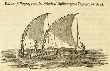
The Balza is a raft of the same construction as those called Catamarans: but in the Peruvian mode of managing it, is to be seen the origin of what has been called sliding keels.*
Sir Richard Hawkins, as is mentioned in his Voyage, saw
* Don Antonio de Ulloa, in his Voyage to South America, has given a drawing of a Balza, with a minute description of its construction and management, which corresponds with the drawing in Spilbergen′s voyage. From Ulloa′s work the following particulars are transcribed.
Ulloa′s Description of the Balza. Construction.
The Balzas, or Jangadas as they are sometimes called, are of different sizes, some being used in fishing, some for the carriage of goods in the river of Guayaquil, and some of them navigate along the coast as far as to Payta. They are composed of 5, 7, or 9 poles of a very light wood, which the Indians of Darien call Pucro. In the Castilian language it
has been called Cana Beja, or Cana Heja. Don Jorge Juan has seen the same kind of wood in Malta, where it grows, and by the Maltese is called Ferula. Some of these poles or canes are 12 or 13 fathoms in length, and about 2 feet or 2½ feet in diameter; so that the nine beams joined form a breadth of between 20 and 24 Paris feet. The thickest of the poles of which a Balza is formed, is likewise the longest, and the excess of length is in the after part. Joining to this, one is placed on each side, and the same is repeated in succession till the whole is completed; the one in the middle servingas mother to the rest, by which means the number is always odd. They are fastened by strong rope lashings to each other, and likewise to cross pieces at each end, which render them very secure: but it is necessary to examine the lashings from time to time to see that they are not worn out; for the neglect of such inspection has occasioned some melancholy accidents. The large Balzas have
a second platform or deck of canes, and a covering or shed. Some of them carry from 400 to 500 quintals, without being incommoded by the wash of the sea, either ruuning over or rising up between the spars, by reason that the whole embarkation yields to the motion of the waves.
Management
Thus far, says Ulloa, only the construction and use of the Balza has been mentioned. There remains to be explained the greatest singularity of this embarkation, which is, that it sails and works when the wind is contrary, as well as vessels with keels, and makes good as direct a course. It possesses this advantage by an invention perfectly distinct -from that of a rudder, ′and which experience and necessity have dic- ′tatcd to the Indians, strangers to science:′and in this instance, the contrivances of untutored navigators may be said to have rivalled or even to have excelled the inventions founded on nautical theory. This Peruvian method of steering is by means of ′some planks three or four ′yards in length, and half a yard in breadth, called Guares, which are ′disposed vertically both in the fore part and after part of the Balza, ′between the principal timbers composing it: and by lowering some in ′the water, and by raising up others, they pursue their course, whether ′with a side wind, large, in tacking, before the wind, or in veering, and ′preserve the prow in whatever direction is required.′ The words in the original are, ′Unos tablones de 3 a 4 varas de, largo y media de ancho, ′que llaman Guares, los quales se acomodan terticalmente en la parte ′posterior, 0 popa; y en la anterior, 6 proa, cntre los palos principales ′de ella; por cuyo medio, y el de ahondar unos en el agua, y sacar alguna ′cosa otros, consiguen, que orse; arribe; bire de bordo, por delante, d ′en redondo; y se mantenga a la capa segun coivviene la faena para el ′intento.′ llelacion del Viage a la America Merid. por Don Antonio de Ulloa, Vol. I. lib. iv. cap. 9. 470.
Don Jorge Juan, the associate of Don Antonio de Ulloa, composed a short memoir on the use of the Guare, which is inserted in Ulloa′s work.
Don Jorge has demonstrated that a Guare being put down near the prow of a vessel under sail, will make her luff up (that is, will make her prow point nearer to the wind); and that taking the Guare up will make her fall off or bear away from the wind. And on the contrary, that a Guare being put down in the after part will make the vessel bear away; but being drawn up, will make her steer nearer to the wind. Sometimes five or six Guares are used in a Balza at the same time, to prevent her from making leeway.
The foregoing particulars respecting the Balza, the reader may find explained more at large in Viage a la Amer. Merid. por D. Ant. de Ulloa. Lib. IV. § 465 to 471. It is observable, that the Balza of Ulloa has two poles erected as sheers to serve the purpose of a mast, and a square sail which is fastened to a yard and fitted with bowlines; which fashion of rigging is doubtless, in part at least, European. The Balza in Spilbergen′s Voyage is rigged in a more rude and simple manner, the sails being triangular, and the same stick being made to serve both the purposes of mast and yard.
[page] 343
1615. August. Payta.
Balzas as low down the coast as at Valparaiso, and has described them to be ′rafts made of masts or trees fastened together:′
Balza of Guayaquil, in 1736. From D. Ant. de Ulloa.
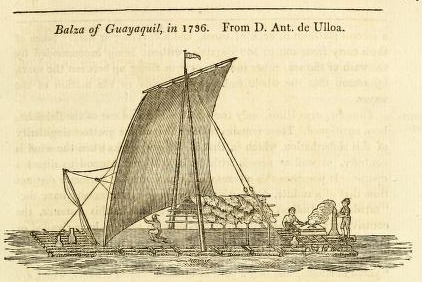
[page] 344
1615.August. Payta.
and the only description given of the Balza in the Miroir, independent of the Plate, is, that ′the natives go in them to ′fish, and that they sail very near to the wind.′
3
[page] 345
CHAP. 18
1615. August. Payta.
The Indian fishermen taken were released, and their Balza was restored to them; but the cargo of fish was distributed among the Holland ships.
In imitation of the journal of Olivier Van Noort, the journalist of Spilbergen′s Voyage has given a short account of the Spanish settlements in Peru and Chili, obtained from one of the prisoners. In this account it is said that Chilue [Chiloe] is a town situated ′at the extremity of the country possessed by the Spaniards ′towards the South; but it is a place of little importance, for ′some time ago a Captain of the Low Countries, named Anthoine le Noir, with only thirty armed men, made himself master of ′the town. Another ship, named le Mariage, stopping before ′the same town, thirty Spaniards surrendered themselves into ′their hands.′ From these circumstances it appears that more enterprises than those which have been published, were undertaken against the Spanish settlements on that side of America:
VOL. II. Y y
[page] 346
1615. August.
and several Spanish authors make casual mention of ′European pirates′ frequenting the South Sea about this period.
August the 21st, Admiral Spilbergen sailed from Payta, and continued his route towards the North. The 25th, it was determined in Council to steer for the Isle de Cocos, at which place they were informed that refreshments would be found.
September.
September the 2d, the prize tender became so leaky, that she was abandoned. They were at this time nearly in the latitude of Cocos, but the weather proved tempestuous with rain and thunder storms, and after some days spent in a fruitless search for the island, the fleet steered for the coast of New Spain.
Coast of New Spain.
October.
Acapulco.
The 20th, they made the land of New Spain in about 13° N latitude. They proceeded Westward, keeping near the coast with light and variable winds, till October the 10th, on the evening of which day they anchored near the entrance of the port of Acapulco.
11th.
The next day, the fleet stood in for the port. As the ships approached, the Citadel fired some shot at them, which did no damage; and on the Admiral sending a boat towards the shore with a flag of truce displayed, the firing was discontinued. By this flag of truce an armistice was agreed upon, and the fleet entered the harbour without offering hostility or receiving molestation. Each party, however, kept prepared to repel attack, and the Admiral placed his ships in the most advantageous positions.
On the 12th, a treaty was concluded by the Admiral with the Governor of Acapulco, the terms of which were, that no hostility should be committed by either side; that the Admiral should release all his Spanish prisoners; and that the Spaniards should furnish the Holland fleet with 30 oxen, 50 sheep, a large quantity of poultry, and of fruits, and with fresh water and wood.
By this prudent negociation the Spaniards saved their town at small expence, and the Hollanders found a relief to their wants, which they could not have obtained by other means The journal
7
[page] 347
1615.
October. Acapulco.
says, ′if we had proceeded with force and gained the town, we should have made small profit, and have got little either of cattle or provisions, as the Spaniards might with ease have abandoned the place, and conveyed their valuables into the forests.′
The contract was performed on both sides with good faith, and several Spaniards of distinction visited the ships, who were honourably entertained. No person belonging to the fleet went on shore on any other occasion than to forward the business of the supplies, except once that the Admiral sent his son and the fiseal to pay a visit of ceremony to the Governor.
On the 18th, Spilbergen sailed from Acapulco, and continued his progress along the coast towards the NW. The 26th, a Spanish vessel was captured, a part of whose crew escaped to the shore. The cargo was of small value, except some provisions which were distributed equally among the fleet. The prize was retained to serve as a tender.
November. Salagua.
November the 10th, towards evening, the fleet anchored before the Port of Salagua, and two boats were sent into that harbour to examine a river which was reported by the prisoners to abound with good fish, and its banks with citron and other fruit trees: they likewise said that at two leagues from thence there were meadows with cattle grazing. When the boats arrived at the river, that and the banks were found to correspond with the description given; but the Hollanders observed near the shore numerous prints of the footsteps of men who wore shoes; and as they hud been informed that the place was inhabited by native Americans only, they had the prndence not to land, but returned to the ships, which had anchored in the port of Santiago.
The next day the Admiral went to the same river with 200 men, but notwithstanding their numbers, as soon as they landed they were attacked by a strong body of Spaniards who had concealed themselves in the woods. The Spaniards were repulsed
Y Y 2
[page] 348
1615.
November.
with some loss, and the Hollanders likewise had two men killed and seven wounded. The place did not appear capable of being, secured against attack, and the ammunition being nearly expended, the Admiral embarked with his men, and returned to the ships.
Port de Navidad.
The 15th, the anchors were taken up, and the fleet sailed to Port de Navidad, Which the journalist reckoned to be three German leagues distant from Port Santiago.* At Navidad they were able to guard against being surprised, and the fleet watered without molestation; and with the assistance of their prisoners, poultry and fruits were procured.
C. May has given with his journal, plans of the ports Salagua, Santiago, and de Navidad, but has not marked in them either depth of water or scale; and the plan of de Navidad being separate from the other two, no scale can be formed. The port of Santiago is to the West of Salagua, and is drawn separated from it only by a point of land.
Spilbergen leaves the coast of America.
December.
2d.
On the 20th, the fleet sailed from Port de Navidad, and it was intended to make Cape San Lucas, for the chance of meeting some vessels from Manila. The winds however proved unfavourable to their plan, on which account, after passing Cape Corrientes, it was determined not to expend more time in that pursuit, but to prosecute their voyage to the East Indies; and December the 2d, the course was directed WSW for the Ladrone Islands, with a prosperous wind. (In the Miroir ′prismes le cours à l′ouest sud ouest, avec assez de prosperité′).
3d.
Islands
Sto. Tomas.
Oh the 3d, they saw two Islands, much to the surprise of the pilots, who did not expect to find Islands at that distance from the American coast.
4th.
La
Annublada.
The 4th, at day-light, they saw a rock at a great distance, which was at first mistaken for a ship; but on a nearer view they
* Dampier has given the distance between de Navidad and Santiago nearly twice as much as is here mentioned. As Cornelisz May sailed from one port to the other, and drew plans ot each, his distance is probably the most correct.
[page break]
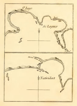
[page break]
[page] 349
1615. December.
were undeceived and much chagrined at their disappointment. ′This rock,′ the journal says, ′is situated in latitude 19°, and is distant above 55 [German] leagues from the main-land.′
6th.
Roca Partida of Villalobos.
′The 6th, at noon, the latitude was observed 18° 20′ N. This same day was discovered in the open sea, another Island, having five hills, each of which had the appearance of being a separate Island.′*
The Islands seen by Spilbergen on the 3d, are the Santo Tomas of Grijalva, and the Santo Tomas of Villalobos. Concerning the other two Islands, it is necessary to rectify an error which has been made in the first volume of this work.
The fourth Island seen by Spilbergen corresponds with Herrera′s account of the situation of the Roca Partida discovered in 1542, by Villalobos †; but the early accounts of that voyage mention only three Islands being discovered in this part of his track, and describe the situations differently. The third Island from New Spain (of the four in question) having been found to have the appearance of a cleft rock‡, led to a conclusion that the name Roca Partida had been chosen purposely for its designation; and accordingly in the first volume that name has been so assigned, and the fourth Island wholly omitted. But the testimony of Spilbergen′s voyage§ confirms Herrera′s account, and renders it proper to place Roca Partida more to the West. The third Island seen by Spilbergen seems entitled to the name
* Miroir, O & W. Ind. p.80
† Herrera, Hist, de las Ind. Occid. Dec. 7. lib. 5. See likewise Vol. I. p. 228. of this work.
‡ See the view of this Island in the Voyage of Captain Colnet.
§ At the lime the former Volume was published, I had not examined the account of Admiral Spilbergen′s Voyage; and since then, likewise, the Relation of the Voyage of the Spanish ships Sutil and Mexicana, published at Madrid in 1802, has come to my hands. The Charly N° I, in the Atlas to the Spanish Voyage, places an Island Roca Partida in 18° 30′ N latitude, and 3 degrees of longitude West from the Westernmost of the three Islands seen by Captain Colnet.
[page] 350
1615. December.
of la Annublada given by Villalobos, and it is so marked in a late Spanish chart.*
From December the 6th to the 1st of January 1616, the fleet steered ′constantly towards the WbS and WSW, with the wind ′favourable, and making good advances.′ In this passage, however, there were many sick people in the fleet, and several died.
1616. January.
Ladrone Islands.
The courses steered between the 1st and 23d of January are not set down in the Miroir. During that period, it is probable they sailed on a parallel. On the 23d in the afternoon, they made the Ladrone Islands, near which they stopped two days to traffic with the Islanders for provisions of fruits, fowls, and fish.
The 25th,. Sybrand Cornelisz, principal merchant in the Morghensterre, being at dinner apparently in good health, was seized with a fainting fit and suddenly expired.
February. Philippine Islands.
The 26th in the afternoon, they sailed from the Ladrones, and on February the 9th, arrived in sight of the Philippines.
The ships of Spilbergen passed through the Embocadero de San Bernardino, and towards the end of the month anchored before the Bay of Manila, near which it was intended to remain till the middle of April, as rich trading vessels from China were expected to arrive about that time.
With the journal is a chart, under the title of the Strait of Manila, on which is laid down the North part of Tandaya and the South side of Luconia from the Embocadero to the entrauce of Manila Bay. The coasts appear to have been drawn with judgement, but without much pains. The greatest difference between this and the later charts is in the distances: the distance from the Embocadero to the entrance of the Bay of Manila, being laid down by May above 80 geographical leagues, which is considerably more than the distance given by the present charts.
March.
In the first week of March, the Hollanders captured many small vessels laden with rice, poultry, cattle, fruits, tobacco,
* The chart mentioned in the preceding note.
[page break]
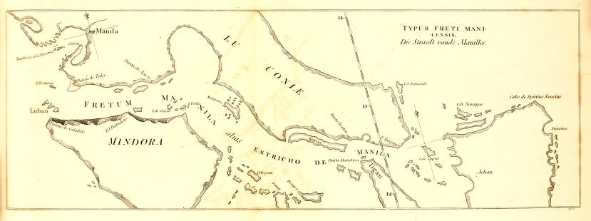
[page break]
[page] 351
1616. March.
and other provisions. Some of these vessels belonged to Spaniards, and some to Chinese and Japanese; but the cargoes of all were presumed to be Spanish property, and as such distributed among the fleet. The only distinction that appears to have been made, was, that the Chinese and Japanese prisoners were released, and their vessels restored to them.
March the 6th, Admiral Spilbergen received intelligence from some prisoners, that all the naval force which the Spaniards had been able to equip at Manila had been sent to the Molucca Islands to oppose the Hollanders: that this force consisted of ten large and many small vessels, in which, besides Spaniards, were embarked a great number of Chinese, Japanese, and natives of the Philippines; and that they left Manila on the 4th of the preceding month [February], under the command of Don Juan de Silves. On receiving this information, the Admiral convened the Council, wherein it was determined to proceed without delay to the assistance of their countrymen at the Moluccas. But previous to their departure, one of the prize vessels, manned with a Chinese crew, was dispatched to Manila with a letter to the Governor, in which the Admiral offered to exchange the prisoners he had for any Hollanders who might be detained at Manila.
On the 8th, four champans (small vessels of the country) were taken laden with provisions, which were equally distributed among the fleet.
Arrives at the Moluccas.
They waited till the 10th, expecting an answer from the Governor of Manila, but no answer arrived; and, on that day, Admiral Spilbergen set sail for the Moluccas. The 29th of the same month, he arrived with his fleet at the Island Terrenate.
The route and proceedings of Admiral Spilbergen in this voyage have been thus far closely followed. His actions in India in the service of the East India Company of the United Provinces, are of a nature foreign to the subject of this work, He remained
[page] 352
1616
among the Molucea and Spiee Islands till near the end of the year, when he sailed with two ships for Europe.
One remarkable circumstance in his passage homeward, is connected with the History of South Sea Discoveries, which will more properly be related in the ensuing than in the present chapter.
Considering that the Expedition of Admiral Spilbergen produced no new discovery of lands in the South Sea, the account of it might easily have been made more brief; but it seemed that in so doing, the reader′s satisfaction would have been abridged, as the events of the voyage receive much addition of interest from the judicious and steady conduct of the commander. Of six ships which sailed in company under his command from the Texel, the five * largest arrived with him at the Moluccas. The prudent management by which so many ships were kept together through such an extensive navigation, the care and attention shown for the preservation of his men, his steady pursuit of his duty in preferring the honour and service of his country to all other considerations, are so many evidences which the conduct of Admiral Spilbergen furnishes to prove that he possessed the most requisite talents of a great commander; and there has seldom been found in the same man such a union of valour and circumspection. Of his genius for enterprize, the following remarkable testimony is given in a Memoir written upon the subject of Voyages undertaken to find a way for sailing about the North to the East Indies. The Memoir says ′William Barentsz sailed Northward as far as to 77° 20′; and upon this supposition (of a passage to India by the North of Europe) divers
* M. de Brasses has said that one of Spilbergen′s ships was lost near the River de la Plata, ′so that his squadron was reduced to four.′ Hist. des Navig. aux Terres Australes, Tom. I. p. 344. M. de Brosses appears to have mistaken the loss of a boat for the loss of one of the ships. The plates to the early accounts, as well as the narrative, show that five ships remained with the Admiral.
[page] 353
voyages have been attempted. And though hitherto the attempt has been made that way only from the side of Europe; yet that famous seaman, Joris Van Spilbergen, would have adventured a voyage the same way from the East Indies, if with much importunity he had not been dissuaded from it.′*
J.Cornelisz May, the journalist of Spilbergen′s Voyage, must be allowed to have contributed to the improvement of the charts of his time, particularly by his chart of the Strait of Magalhanes already noticed, and by a chart which likewise accompanies his journal, of the Islands in the Indian Seas from Sumatra Eastward. His journal also contains ′a description of the number and ′situation of the fortresses, troops, artillery, and shipping, in the ′East Indies in the service of the East India Company;′ from which it appears, that the Dutch Company had 3000 troops, and 37 sail of European shipping, besides country craft, in the East Indies, in July 1616.
To the early publications of Spilbergen′s voyage is prefixed a Map of the World in a double hemisphere, which is to be considered merely as an ornamental frontispiece furnished by the editor; and is noticed here only on account of the track being marked on it erroneously, and not agreeing with the narrative.
* Philosophical Transactions, A.D. 1674, Vol. IX. Paper N° 103.
VOL. II. Z z
[page] 354
CHAP. XIX.
Voyage of Jacob Le Maire and Wilhelm Cornelisz Schouten, round the World.
CHAP. 19
THE expedition of Admiral Spilbergen to the South Sea was closely followed by another, which proved no less creditable to the maritime reputation of Holland; though in other respects not equally important to the interests of that country.
By the charter which the States General granted to the Dutch East India Company, all other subjects of the United Provinces were prohibited from sailing Eastward round the Cape of Good Hope, or Westward through the Strait of Magalhanes: but this charter, which was intended to give an exclusive trade to the Company, did not secure all the avenues to India.
A belief that to the South of the Strait of Magalhanes there would be found either an open sea, or some other passage leading to the South Sea, had many years been gradually gaining strength. The termination of the coast of the Tierra del Fuego on the Eastern side, had been seen as early as the year 1526; and the expedition of Drake round the World, in 1578, had ascertained the fact of an open sea to the South of the Tierra del Fuego: but the discovery made by Drake was little known. No clear information concerning this part of his voyage could be gathered from the accounts at that time before the public; for the narrative entitled The World Encompassed, was not printed before the year 1628.
During this obscure state of the question, about the year 1613, some enterprising merchants in the United Provinces, from frequent consultations on this subject, became so strongly persuaded of the existence of such passage or passages, that they formed the
[page] 355
design of fitting out ships to make the experiment, which, if successful, would open to them a trade to India by a passage not interdicted, and, it was hoped, amply repay them for their risk and expence. The merchants principally engaged in this speculation were, Isaac Le Maire of Amsterdam, Peter and Jan Clementz Kies, and Jan Janszon Molenwerf.*
As a necessary preliminary step to their enterprise, they presented an application to the States, demanding, ′that in recompense of the danger, labour, and expence, they were ready ′to take upon themselves for the discovery of new passages, ′harbours, or lands, there should be granted to them the privilege, to the exclusion of all other persons, the subjects, of the States, to make the first six voyages to the countries which they should discover.′ In consequence of this application, the States General decreed as a general regulation, that ′all persons, inhabitants of the United Provinces, who should make ′discoveries of new passages, harbours, or lands, should be permitted and entitled to make the first four voyages to the places by them discovered;′ and all other inhabitants of the said provinces were forbid, under the penalties of confiscation of ships and merchandise, and payment of a fine of 50 000 ducats for the benefit of the first discoverers, to navigate or trade in such places, until the said four voyages were completed. It was stipulated as a condition that the discoverers should within two weeks after their return from their first voyage, make a report to the States General of all their navigation and success: and it was at the same time declared that this Grant was not to be understood to authorise any act in prejudice or derogation of any charters or permissions before granted. This decree is dated March the 26th, 1614: and under its authority, Isaac Le Maire and his coadjutors formed themselves into a Company.
* Journal et Miroir de la Navigation Australe du Jaques Le Maire. Preface.
Z Z 2
[page] 356
The views of the new Company in this arduous undertaking, may be said to have been wholly commercial. They fitted out two ships, whose force was not greater than was required for their security among the uncivilised inhabitants of the countries they expected to fall in with. The projected voyage was necessarily to be one of discovery, because they were restricted from going to India by the known routes.
The conduct and management of the enterprise was confided to two persons jointly. Jacob le Maire (the son of Isaac) was appointed by the Company to go with the ships as principal Merchant and President. Wilhelm Cornelisz Schouten, an experienced seaman, was appointed Patron, or Master Mariner. As an additional sanction to the undertaking, a license was obtained from the Prince of Orange, which was written in the style of an address to all foreign potentates by whom it should be seen, notifying to them that ′Jacob le Maire, Captain and President of the two ships Eendracht and Home, and Wilhelm Cornelisz Schouten, Ship Patron *, had permission and authority from him to go to the Empires and Kingdoms of Tartary′ China, Japan, the East Indies, Terra Australis, Islands and Lands of the South Sea, to the Isle of Rotta†, to passages North and South, and others which they might discover, to contract alliances with the inhabitants, to trade, &c.′ and finally, those who embarked in this expedition were commanded not to offend or injure any one unless they were themselves first assaulted. This instrument is signed Maurice de Nassau; and dated May 13th, 1614. It is said ‡ that the scheme of the voyage was kept a secret from all bnt a few of the principal merchants, who were Directors of the Company, and that
* ′Patron de Navire.′ A copy of this license is prefixed to the account, entitled, Navirwtion Australe de J. Le Maire.
† To the SW of Timor, and the Southernmost land at that time known of the Eastern archipelagos.
‡ By the editor of the Merveilleux Voy. de Guil. Schouten.
[page] 357
the officers and mariners employed were engaged with the condition to sail whithersoever the commanders and merchants chose to go. The privileges which they had demanded clearly evinced their destination to be the South Sea or the East Indies: the proposed route would not be easily conjectured, and the Company by many were named the Gold Seekers; but the merchants themselves took the title of (Compagnie Australe) the Southern Company.
Account of the early Publications of the Voyage.
The history of the early publications of this voyage involves a contest between the two principal leaders for the honours of the discoveries which were made: and would have been understood with less explanation, if it had been deferred to the conclusion of the voyage, to which the circumstances attending its publication would have been a natural sequel; but the convenience and satisfaction to the reader in being previously acquainted with the authorities to which he is frequently referred in the course of the narrative, has caused a preference to be given to the contrary method.
In 1617, the year in which the voyage terminated, the Journal of the Voyage of Wilhelm Schouteu was published at Amsterdam,, in the Dutch and French languages; a publication which gave much offence to the friends of Jacob Le Maire, as it ascribed the merits of the navigation and discoveries solely to Wilhelm Schouten. In the year following, it was published in the German language.
In 1619, another edition of the French, with the title of Journal ou Description du Merveilleux Voyage de Guillaume Schouten, was published at Amsterdam, by Haman Janson, with plates: and in the same year likewise, Descriptio admirandi itineris a Gullielmo Schouten Hollando peracti, with plates, was added to the Collection of Voyages, by De Bry. America, pars XI. The earliest of the Amsterdam editions that I have met with, is that of 1619. M. Camas, in his Memoire on the
[page] 358
Collections of Voyages by De Bry and Thevenot, p. 149, notices the three editions of a more early date; whether they were accompanied with plates is not mentioned, but one of them, published at Amsterdam, by W. Jansz [Janson], is the original publication of which the friends of Le Maire complained. The plates to De Bry′s and to Janson′s edition are not the same, but they are engravings from the same designs, with some small variations. In the frontispiece to each there are representations of two Terrestrial Hemispheres, over which are placed the busts of Ferdinand de Magalhanes and of Willem Schouten, with their ships, the Vitoria and Eendracht. The sides of the Frontispieces are decorated with portraits of other circumnavigators, but that of Jacob Le Maire is not among them, nor does his name appear in the title page. The preface states that the plan of the voyage was projected between Isaac Le Maire (the father of Jacob) and W. Schouten, and adds with less appearance of probability, that W. Schouten, by the means of his friends, furnished a moiety of the expence of the equipment. Willem Schouten is styled the Master Mariner and principal Governor, and Jacob Le Maire the principal Merchant and Commissary. No authors name is affixed to this journal: De Bry says, it is composed, ex scriptis et ore eorum qui et prœsentes ista videre ac experti sunt: and the Preface to the Merveilleux Voyage, that ′the things which happened in this voyage are amply and faithfully described in this treatise, by those who were eye witnesses.
A Relation of the Voyage of W. Schouten was printea in London, in 1619, without plates, except in the title page a representation of the Strait Le Maire, there called the New Passage. The principal recommendation of this London edition is, that it appears to be a translation from the original publication.
In 1621, was published at Amsterdam, the Miroir Oost et West Indicai, in which was printed the same Journal, but with
[page] 359
the altered title of Navigations Australes Descouvertes, par Jacob Le Maire; and in the charts, the track, which in the former publication was called the track of Willem Schouten, is here called the Navigation of J. Le Maire.
In 1622, printed also at Amsterdam, appeared the Journal & Miroir de la Navigation Australe de Jaques Le Maire, Chef & Conducteur de deux Navires. A Preface to this Journal declares that ′the Directors of the Compagnie Australe, being willing to publish the authentic and original journal of Jacob Le Maire, who sailed in search of the Terre Australe, have thought proper to caution the reader, that the journal put forth by Jansz is not the true journal of the said navigation, but a work surreptitiously obtained, and unfairly published, not only in being to the prejudice of the Company, to whom, as they possessed the original journals, it belonged to publish such an account, but in attributing the discovery of the Strait Le Maire to Willem Schouten, who went only in the quality of Mariner, and was not the contriver of this navigation; and who had no previous knowledge concerning it farther than had been communicated to him by the Directors, as he acknowledged himself by letters written in 1618.′ The Preface likewise denies that W. Schouten contributed towards the expence of equipment. ′And for as much as W. Jansz has published his book under the name of Will Schouten, be it known to the reader, that Schouten is not the author of that history, he having disowned that book in his letters, and blamed W. Jansz.′ The rest of the preface contains some remarks on the comparative merits of Willem Schouten and Jacob Le Maire, favourable, as may be supposed, to Le Maire.
There is no signature to this preface. In the commencement, the writer insinuates, without venturing to affert, that this Journal de la Navigation Australe is the original and authentic journal of Jacob le Maire; but in no other shape does either the title, preface, or any part of the publication, pretend to give the reader
[page] 360
any information whose journal it is that is thus presented to him. On comparison, the fact appears, that the greater portion of the Navigation Australe de le Maire, is taken from the Journal du Merveilleux Voyage de W. Schouten, and that the editor has endeavoured to disguise the plagiarism by verbal alterations. The plates of the Marveilleux Voyage are copied, omitting the frontispiece, to embellish the Navigation Australe; and the compiler or publisher had not invention or spirit sufficient to introduce a single plate representing any new subject. The chart of the Strait Le Maire, with the Tierra del Fuego, is something improved in the Navigation Australe. The other charts, with only one small variation that requires notice, are copied from the charts of Schouten′s Voyage, except that the meridian lines are differently placed; but the alteration is ill managed, and has not made the distances in the charts agree with the distances given in the journal which they accompany. The only remarkable differences between the Navigation Australe and the accounts before published, are, the distances in the reckonings, and some of a personal nature respecting the President and the Patron. The occasions which produced the latter, the reader will find in the relation of the voyage. It must be supposed that a narrative countenanced by the Compagnie Australe would have possessed more of originality if Jacob Le Maire, whom the editors wished should be reputed the author, had been living at the time of its publication.
In the Recueil des Voyages a l′Establissement de la Comp. des Indes Orient. Vol. S. Edit. 1725. Rouen, there is an account of the voyage with the title of Navigation Australe par Jac. Le Maire, et par W. Corn. Schouten, said to be ′drawn up from the journal ′of Adrien Claesz, from many other writings, and from oral information of those who performed the voyage.′ This is composed from the prior publications, without, any addition of importance except one circumstance respecting the reckonings.
11
[page] 361
Every one of these accounts of the voyage are in fact anonymous, so much so, that they afford no document which can authorise the fixing a single paragraph in any one of the journals upon any particular author. The Merveilleux Voyage de Schouten, and the Navigation Australe de Le Maire, have nevertheless always been regarded as authentic accounts, and there is sufficient reason to be satisfied, not only from their agreement respecting facts, but from the nature of the circumstances related as well as by the manner of relation, that the information they contain is genuine. The Voyage of Schouten, however, is the only one of the accounts that has the appearance of a journal in its genuine state. It is evidently the groundwork both in form and matter of those which followed, and has always been supposed to be the journal of Wilhelm Cornelisz Schouten; and the accounts of the reckoning in the navigation across the Pacific Ocean, furnish argument in corroboration of the general opinion.
The copies of the Act of the States respecting new Discoveries, and of the license granted to Le Maire and Schouten, do not accompany any other account than the Navigation Australe de J. Le Maire; and it is remarked by M. Camus, that they give additional interest to that edition of the voyage.
Having entered so fully into the history of the early publications of the Voyage of Le Maire and Schouten, it is only necessary to notice farther, that, except in instances where other authority is specified, the Journal du Voyage de Schouten and the Navigation Australe de Le Maire have supplied the facts related in the ensuing Narrative.
1615.
Equipment.
The vessels fitted out by the Compagnie Australe were, a ship named the Eendracht, of 360 tons burthen, which carried 19 guns, besides other arms, with a company of 65 men; and a galiot (fuste) named the Home, of 110 tons, carrying 8 guns
VOL, II. 3 A
[page] 362
1615
and 22 men. The President Jacob Le Maire and the Patron Wilhelm Cornelisz Schouten sailed together in the Eendracht. The Home was commanded by Jan Schouten, brother to the Patron, and Adrian Claesz sailed in her as merchant. To each vessel two pilots were appointed.
Departure from Holland. June.
On June the 14th, 1615, they sailed from the Texel.
The 17th, they anchored in the Downs, where they hired an, English gunner. They afterwards stopped at the Isle of Wight, and at Plymouth, at the last of which places they hired a carpenter, and sailed thence the 28th.
July. Cape Verde.
July the 8th, the carpenter′s mate of the Home died..
The 23d, they anchored at Cape Verde, where they obtained very little provisions, and for leave to take fresh water the natives obliged them to pay eight bars of iron and some bottles of Spanish wine.
August. Sierra Leone.
August the 1st, they left Cape Verde. The 21st, they had sight of the high land of Sierra Leone, and stood for the river; but not having good directions for finding the proper road, they got among the smaller branches of the river, or into some other rivers, near that of Sierra Leone, where the country was not inhabited. They found here lemons growing wild, and oysters which hung to the branches of trees that stood in the salt water: and saw wild cattle, apes, and other beasts, crocodiles, tortoises, swans, and partridges.
The 30th, they anchored in the proper road of Sierra Leone, where they procured plenty of fish, bananas, lemons, and fresh water. The Home was laid aground here, and her bottom cleaned. A sea stock of 25 000 lemons were purchased of the inhabitants for a few beads: and so great a quantity of this fruit grew in the woods, that they might with ease have loaded their ships with them.
September.
In the beginning of September, they sailed from Sierra Leone, but calms and contrary winds, which were accompanied with heavy rains, kept them near the African coast till near the end of the month.
[page] 363
1615. October.
October the 5th, they were in latitude 4° 17′ N. About noon on that day, a great noise was heard on board the Eendracht, which seemed to proceed from under the fore part of the ship, and immediately after, the sea around them became red, as if blood had been poured into it. Afterwards (on their arrival in port), a large piece of the horn of some sea animal was found sticking in the bottom of the ship, 7 feet below the water line. It was inserted half a foot, deep into the ship, having passed through the planking, and into one of the ribs; about the same length remained without, where, with the violence of the stroke, the horn had broken. It was nearly of the same shape and thickness as the end of a common elephant′s tooth; was full, sound, and very hard.
Dorados.
The 10th, they caught eight ′Dorados*;′ and on the 15th, 40 Bonetas, which is an extraordinary number of those fish to take in one day. The 20th, they passed the Equinoctial line; and on the 25th, the plan of the voyage, before known only to the President and the Patron, was publicly announced to the officers and seamen of both vessels, who were informed that they were bound for the South Sea by a passage which was to be sought by them to the South of the Strait of Magallianes; that when this passage should be discovered, it was intended to go to the Terra Australis (by which was meant the Australia del Espirita Santo of Quiros, supposed to be the Southern Continent), and if they should be disappointed in their expectations of finding great riches there, they were then to sail on to the East Indies. This communication was well received by every one on board, and to animate them the more, there was read publicly in the steerage one of the memorials of Pedro Fernandez de Quiros, which was listened to by the seamen with great eagerness, and some of them, that they might not forget the name Terra Australis, wrote it in their caps with chalk.
* Dorados, or Golden fish, seems to have been the name then given to the fish now called Dolphins. The Dolphin of the ancients (the curvi Delphines) was doubtless the fish now called Porpus, or Sea Hog (Marsouin).
3 A 2
[page] 364
1615. December.
December the 4th. In latitude 47° 25′ S, they struck soundings at 75 fathoms depth, sandy bottom; and on the 6th, at four in the afternoon, they saw the American coast In the evening, they anchored in 10 fathoms, a league and a half distant from the coast, and a small distance to the North of Port Desire, where they found a tide running as strong as the tide before Flushing.
Entrance of Port Desire.
The 7th, at daylight, they weighed anchor, and Olivier Van. Noort′s journal was consulted for directions to find Port Desire, but it being high water, the tide had covered some rocks near the Northern point of the entrance, which are mentioned both by Van Noort, and by Fuller*, and some rocks or small islets being visible near the South point of the entrance, they were deceived and ran past the Port. On finding their mistake, they anchored a short distance to the South of the entrance, in 4½ fathoms depth, to wait for the flood: when the tide fell to the lowest, however, they had only 14 feet depth, and the fore part of the ship took the ground. The bottom was rocky, but fortunately the wind was from the land, and the sea smooth, and no damage ensued. At this anchorage they caught smelts 16 inches in length, on which account it was named the Bay d′Esperlans.
8th.
In Port Desire.
The next morning, they got clear of the Bay d′Esperlans, and anchored right before the entrance of Port Desire. In the afternoon, they entered the Port, having 12 fathoms depth in the channel, and when they had sailed about a [German] league and a half within the entrance, they anchored in the main stream in 20 fathoms. The bottom here was slippery stones and their anchors did not take good hold; so that in less than an hour after anchoring, the wind blowing fresh from the NW, both the vessels were driven on the South shore. This happened about the time of high water. As the tide fell, with the steep-
* See p. 67 of this volume.
[page] 365
1615. December. Port Desire.
ness of the shore the Eendracht slid down and kept afloat; but the Horne was lodged on the shore and left dry at low water. With the next flood tide both vessels were got into the stream again; and on the 9th, they moved farther within the harbour to a safe birth behind the Island, marked in the plan of the Port Isle du Roy; which was the same place where the ships of Van Noort had formerly found secure anchorage.
Provisions found in Port Desire.
In Port Desire and from Penguin Island, they took a plentiful supply of sea lions, penguins, sea birds of many kinds, the eggs of sea birds, herons and bitterns, and fish. Some of the sea lions were 16 feet in length, and no other way was found of killing them than by shooting them in the belly or in the head. The Isle du Roy was almost entirely covered with the eggs of sea birds like those of a lapwing, but rather larger, which were good eating. Among the birds caught were a species of geese; and in one day, two tons of smelts were taken with nets.
One of the earliest cares of the Hollanders was to search for fresh water, and they dug wells in different places, some 14 feet deep; but during the first fortnight of their stay in this port, they found no other than brackish, water, ′as well in the mountains as in the vallies.′
Upon the summits of hills and upon high rocks, were observed the heaps or hills of stones, noticed in the account of Olivier Van Noort′s voyage, where the natives deposited their dead. Some of the people of Le Maire and Schouten′s ships had the curiosity to remove the stones of some of these heaps, and they found the bodies of the deceased natives laid upon the ground, without any grave being dug. The stones heaped over and round the bodies were supposed to be for the purpose of protecting them from birds and beasts. It is said (first in the Merveilleux Voyage de Gu. Schouten, from whence it seems to have been copied into the other accounts) that some of the human skeletons thus found were 10 or 11 feet in length,
[page] 366
1615.
December. Port Desire.
The Horne burnt by Accident.
The ship and the galiot were both laid aground at high water, to be cleaned. On the 19th in the afternoon, as they were burning reeds under the bottom of the Horne which the falling of the tide had left dry, the flames suddenly caught within board, and communicating with the rigging, the fire increased with great rapidity. Unfortunately at this time the sea had retreated so much from the vessel, that the water was 50 feet distant, which rendered it impossible to stop the progress of the flames. In a short time the powder took fire, and after the explosion, the remains of the vessel continued burning the whole night. The next day, the anchors, guns, iron work, and all of her that could be found which fire or water had not destroyed, was taken into the Eendracht. Of the merchandise, 37lbs. weight of silver were recovered, some of which was found thrown to a considerable distance from the wreek; 14 cwt. of lead and some pewter were saved.
Fresh Water found.
Watering Place.
Animals had been frequently observed crossing some mountains near the ship; and it at length occurred that their object might be to get fresh water. On the 25th, the President sent people to search in that direction; and two pits or hollows containing fresh water were discovered. The pits were made deeper to procure an increase of the quantity, and the next day four tons of water were filled. The water was whitish in colour and thick, which was occasioned by the disturbance made by the animals in drinking, and by the soil underneath being a white clay; it was nevertheless good and soft. This watering place was on the Northern side, and very distant from the shore of the harbour, as appears in the plate representing Port Desire. The water was conveyed to the ship in runlets (small casks) which the men carried on their shoulders, and every waterer was attended by an armed man. In this mode of watering, the Dutch seamen shipped in one day 10 tons of water.
Most of the drawings of places given by the early Dutch navigators are rude and disproportionate representations: but by
11
[page break]
[page break]

[page] 367
1615. December.
Port Desire.
their method of combining map and picture, though done at the expence both of perspective and correct measurement, much information and a clear general idea is communicated. The figures introduced are likewise defective in point of neatness and correctness, but are seldom without character. The annexed plate is copied from a plan of Port Desire in the Journal du Merveilleux Voyage de Schouten, edit. 1619.
Explanations of the Figures given with the Plan of Port Desire.
| A. | The Bay d′Esperlans, where we went by mistake, and remained a night in great danger of losing the ships. |
| B. | The place where the ships were cast on the shore. |
| C. | A small Island where we took many young birds. |
| D. | The Isle of Lions. |
| E. | The Isle du Boy, behind or rather within which we moored: the ship. |
| F. | The place where the galiot, the Hore, was burnt. |
| G. | The place where we found water. |
| H. | The sepulchres of men of large stature, where we found skeletons 10 or 11 feet long, the skulls of which we could put on our heads in the manner of helmets. |
| I. K. | Representations of Sea Lions and Lionesses, some of which we took and eat. |
| L. | Animals of a kind resembling the stag [cerf], but with the neck as long as all the rest of the body; very swift of foot. We saw many of them every day on the mountains. |
| M. | Ostriches, of which we saw great numbers. |
| N. | A forked rock on the summit of a hill, which at a distance appeared like a building formed by human labour.* |
* The explanation here given to N, is in pari taken from the Navig. Aust. de le Maire. This remarkable rock is at present known by the name of the Tower Rock. Its situation, as observed in 1766, by Mr. Harrison, purser of His Majesty′s ship in Captain Wallis′s Voyage, is lat. 47° 56′ S, and long. 67° 10′ W. from Greenwich. Astron. Obsns made in Voyages for making discoveries, undertaken by order of His present Majesty, drawn up by William Wales, p. 3. London 1788. In the Spanish Atlas of 1798, the Tower Rock is placed in lat 47° 46′ S, and long. 59° 45′ W. from Cadiz, equal to 66° 2′ from Greenwich.
[page] 368
1615. Port Desire.
The reader is to observe, that in this plan of Port Desire the upper part of the page is the South, a practice which has been adopted by some geographers for places in South latitude, that the elevated pole may appear the uppermost. Of this practice it may be remarked, that it will not apply to all cases, and is such a departure from general custom as must be apt to create perplexity, which is not compensated by its affording superior convenience, or other advantage of any kind.
None of the natives made their appearance whilst the ship was in this port, but distant smokes were observed. Ostriches, and some other animals with long necks, thought to be of the deer kind, but which it is probable were horses, were seen at a distance.
1616. January.
Some disagreement appears to have occurred at this place between J. Le Maire and W. C. Schouten; but the cause is obscurely told. The Navigation Australe de J. Le Maire relates, that on January the 3d, ′the President began to set down his determination in writing: he was informed by Adrien Claesz that the Patron would make a difficulty to subscribe it, and without being willing to assign his reason.′
To prepare the ship for a stormy latitude, the great guns were put down in the hold, and every thing that could be spared from the deck or rigging, which by being exposed to the wind would prevent the ship from being weatherly, was taken below the deck.
January 13th. With one ship only, the Eendracht, Le Maire and Schouten sailed from Port Desire, and directed their course Southward.
[page] 369
1616.
January.
Davis′s Southern Islands. 20th.
The 18th, they had sight of Davis′s Southern Islands, in the journals of this voyage called the Isles of Sebald de Weert.
The 20th, at noon, they had passed the latitude of the entrance of the Strait of Magalhanes, and by their estimation were 20 leagues distant from the land of the Tierra del Fuego. Much sea weed was passed, which was supposed to have drifted from the Strait.
21st. 22d.
The 21st, they were in latitude 53° S. The 22d, the winds were light, and they advanced but little.
23d.
Tierra del Fuego.
The 23d, in the morning, the winds were light and variable. At noon, soundings were obtained at the depth of 50 fathoms, the bottom black sand with small stones; but the sea was of a pale whitish colour. Afternoon, a breeze sprung up from the North, with which they steered SbW, and at 3 p. m. the land of Tierra del Fuego appeared to the West and SW. In a short time after, a continuation of the land was seen extending to the South and SE. The course was directed ESE, with the hope ′to arrive at the end of the land.′* The wind increased, and they continued on a course following the line of the coast. In the night they had soundings at 14 fathoms depth.
24th.
At daylight the next morning (the 24th), a continuance of the coast was seen to extend far Eastward, which was great discouragement to their hopes: but a more favourable prospect was soon presented to them. The important discoveries of this day are clearly and concisely related in the Journal de Merveilleux Voyage. The following extract is given from that account, which will with ease be understood by consulting the chart of the Southern parts of America. †
′The 24th, at the break of day, we saw the land [of Tierra del Fuego] on our right hand, not more than a good league
* Merveilleux Voyage, p 18.
† Vide Vol. I. Plate the first preceding the Appendix.
VOL. II. 3 B
[page] 370
1616.
January.
New Strait discovered.
distant from us, and had soundings at 40 fathoms. The wind was from the West, and the coast extended towards the EbS with very high mountains entirely covered with snow. We sailed alone the coast, and about noon we came to the termination′ of this land, and we saw another country towards the East, which likewise was very high and mountainous. We judged these lands to be about eight leagues distant the one from the other, and it appeared to us that between the two there was a good passage: and what strengthened us in this opinion was, that the tide ran with great violence towards the South between the two lands. At noon we observed the latitude 54° 46′ S.
′After noon, the wind was from the North, and we stood for the said opening; but in the evening the sea became calm, and there was little wind. We saw in this place a number almost infinite of penguins, and so great a multitude of whales, that we were incessantly obliged to alter the course to avoid running against these great sea monsters.′* The Navigation, Australe mentions in the remarks of this day, that there was a point Easterly variation.
25th
They pass through.
The 25th in the morning, the wind was from the North, and they sailed towards the South, having land on each side, and a clear sea before them. The land to the East was high and craggy. It was named (′d′un commun accord′) by general consent, Staten Land, in honour to the States of Holland; and the land to the West (which was the Easternmost part of the Tierra del Fuego) they named Mauritius de Nassau. No trees were seen on either land; but on both sides of the passage there was the appearance of good bays with sandy beaches, and the bottom was every where sandy. At noon, the latitude was observed 55° 36′ S. The coast of the Staten Land was remarked to turn
* Journal du Merv. Voy. de Gu. Schouten; p. 18. 19.
[page] 371
1616
January.
towards the East, and the coast of Tierra del Fuego, along which they bent their course, took a direction WSW as far as they could discern it.
In the evening the wind became contrary, but they had good evidence that a wide sea was before them, from the colour of the water being blue, and by long waves coming from the SW. The sea birds not being accustomed to see men, alighted in the ship without dread, and suffered themselves to be taken by the sailors.′
26th.
Cape Home.
The 26th, they had a storm from the West and SW, which lasted 24 hours. The wind continued many days after this unfavourable, but not fixed, and advantage was taken of its veerings, so that they continued to gain ground towards the South West. On the 29th, about noon, they passed to the North of some small rocky islets, which were named" the Isles of Barnevelt. Three other small Islands were seen to the North of the Bamevelt Isles, and the land of Tierra del Fuego appeared to the NNW, and likewise to the West all high hilly land covered with snow, ending [to the Southward] with a sharp point, which was named Cape Home,′ in honour of the town of Home in West Friesland, of which the Patron was a native. The latitude of this Cape was estimated to be 57° 48′ S. †
They sailed to the South between the Barnevelt Isles and the land of Cape Home, the wind being from the North. On the morning of the 30th, having passed to the South of the Cape, they steered to the West, and encountered great waves which came from that part of the horizon; but they found a current setting strong Westward.
* Navig. Aust. dt Le Maire, p. 130.
+ This latitude is given in eucli of the Journals. All the latitudes set down in this part of the voyage are too much to the South, but more so in this than in any other instance; the latitude of Cape Home being only 55" 58′ ] S,
[page] 372
1616
January.
The 31st, they had passed the Cape, and were out of sight of land, when the wind came from the Westward, but was very variable, which obliged them often to change their tack.
February.
February the 2d, the compass was found to have 12 degrees variation, North Easterly.
59° 30′ S.
The 3d. By their reckoning this day, they were in 59° 30′ S, which was their greatest South latitude; and from this time they advanced with variable winds towards the NW, without seeing any land. They had frequent storms, and the weather was constantly wet, sometimes with rains or mists, and sometimes with snow or hail.
In the South Sea.
The New Passage is named Slrait Le Maire.
Objections made against the Name.
February the 12th, they reckoned themselves to be in the latitude of the Strait of Magalhanes, and believed that they had now completely attained entrance into the South Sea, for joy whereof triple allowance of wine was given to the seamen. On this day it was resolved in full Council, at the request of the President, Jacob Le Maire, that the passage newly discovered (between the Tierra del Fuego, and the Staten Land) should be named Struit Le Maire. This resolution was drawn up in writing in the form of an act of taking possession of the new discovery, and, according to the account in the Navigation Australe, was subscribed by Jacob Le Maire, Wilhelm Cornelisz Schouten, and the pilots. The editor of the Navig. Australe de Le Maire has not neglected to insert in his account, a copy of this instrument. In the Merveilleux Voyage the circumstance is related in the following words: ′At the instance of the Commissary Jacob Le Maire, the Council ordered that the new passage should be named the Passage or Strait of Le Maire, although of good right it would have been better named the Strait of Wilhelm Schouten, our ship master, by whose industry, good management, and knowledge in navigation, the discovery was principally effected.′ The same remark is
[page] 373
1616
January.
made in De Bry*; in the Miroir O. & W. Indical; and in the Rec. des Voy. a l′etabl. de la Comp. The Chart to the Merveilleux Voyage marks the new Strait, Fretum le Maire a W. Schouten primum inventum et lustratum. An. 1616.
On the comparative merits of the different claims, it is not easy to decide. Jacob Le Maire was invested by the Company of Proprietors with at least as much power over the destination of the ship as the patron Schouten; and as principal merchant, it is probable that his influence among those who composed the Council, was strongest. To W. C. Schouten, the care and management of the navigation had been wholly committed. The honours of the discovery, however, are not to be apportioned entirely among the persons who performed the voyage: there are other claims equal to those of Jacob Le Maire and W. C Schouten. With respect to discovery, the expedition they conducted was distinguished from all others which had been made to the South Sea since the time of Fernando de Magalhanes, and was the only one which could in any degree be brought in comparison with the voyage of that fiist discoverer. The discovery of this second passage into the South Sea by the South of America was not accidental or unforeseen. The probability of its existence had been meditated as a subject of speculation; and the route by which it was to be sought, was planned in Europe. To the sagacity of those who conceived the design of this voyage, and to the spirit of the merchants who ventured their capitals on an experiment so hazardous and unpromising in aspect, the world are primarily indebted for the knowledge of the navigation round the Tierra del Fuego. In the instance of Magalhanes, he was both the projector and the accomplisher of his own discovery, and the honour of the
* ′Fretum Le Maire appellarunt, quamris meliore jure Fretum Guilhelmi ′Schouten dici debuisst.′ Pars XI. America.
[page] 374
1616
February.
achievement remains wholly to himself undisputed. The voyage for the discovery of the second passage appears to have originated with Isaac Le Maire; and the plan to have been concerted principally between him and W. C. Schouten, notwithstanding what is asserted to the contrary in the preface to the Navigation, Australe de Le Maire. Indeed it is not at all credible that Schouten, who had before made three voyages to India, should be trusted with the management of the navigation in this voyage, and not be consulted respecting the route: or that his advice did not contribute to determine the measures to be pursued. The principal promoter of the undertaking, however, was Isaac Le Maire; and if the name of Strait Le Maire had been given to the new discovery professedly as a mark of honour to Le Maire the elder, it would have been less liable to objection, and probably would not have given offence; but the intention was to honour the president Jacob, ′to the end,′ the Navigation Australe says, ′that the glory of the action which he had so courageously undertaken and so happily executed, should remain to him perpetually.′
As the elder Le Maire was not thought of in the question, the President would have acted more judiciously if he had limited his wishes to sharing the reputation of the discovery with the Patron, and had procured for the new passage the name of the Strait of Le Maire and Schouten.
To return to the narrative, the ship continued to advance Northward. On the 27th, having arrived to the latitude of 40° S, the guns were again mounted upon deck.
March. Juan Fernandez.
March the 1st, they made the Islands Juan Fernandez and Mas-a-fuero, each of which is high land; and it was their wish to have stopped at Juan Fernandez; but not knowing where the anchorage was, they went to the West side of the Island, in consequence of which they were not afterwards able to get the ship into the road, which is near the NE part. A boat was
10
[page] 375
1616.
March.
sent to the shore on this and on the following day. Some fresh water was taken off, and two tons of fish were caught with hooks and lines, the bait being taken as fast as it could be thrown into the water, so that the fishermen ′continually without ceasing ′did nothing but draw up fish,′* mostly bream, and corcobados, which are fish with crooked backs. Hogs, goats, and other animals were seen in the woods, but none were taken.
On the 3d, the ship had driven four leagues to the North of the Island, and the wind, which was from the Southward, did not afford any prospect of their being able again to approach the shore. They therefore made sail to pursue their voyage across the Pacific Ocean, greatly disappointed at having missed the anchorage, the sick men especially, whose number was at this time considerable.
From Juan Fernandez the course was directed NWbN.† The 11th, they crossed the Southern Tropic, and steered NW,‡ having the general trade wind.
The 15th, the latitude was 18° S, and the course was changed, to West.
The 17th, the latitude was observed 19° S, and the course directed WNW.
* The accounts of the voyage mention that the Spaniards sent barks from the coast of Peru to catch fish at Juan Fernandez; but it is not said whether this was known from marks being visible of the Spaniards having frequented the Island for that purpose, or from other information.
† The reckoning in the navigation of Schouten and Le Maire across the South Sea, is given much more fully and consistently in the Merveilleux Voyage de Gu. Schouten, than in any other account: that journal has therefore been followed in the text above, except where it is otherwise specified. lu the Recueil a l′Etabl. de la Comp. there are some variations from the other accounts which appear to have arisen from negligeuce in transcribing, or in the press; for which reason it has not been thought necessary to remark on every instance wherein that publication differs from the early accounts.
‡ In the Amsterdam edition, 1539, of the Merveilleux Voyage, the course is set down NNW at crossing the tropic of Capricorn. The English translation (London, 1519), has given the course at the tropic, NW; which is corroborated by the Nav. Aust. de Le Maire.
[page] 376
1616
March.
The 20th, the latitude was 17° S. Long hollow waves came from the South. Found the variation ′six degrees towards the NW.′
The 24th, being in latitude 15°, a West course was steered, with the intention of keeping near this parallel to seek the Terra Australis. A fresh wind from the ESE, and constantly the same hollow sea from the South.
April.
April the 3d. The latitude was 15° 12′ S. The needle was found to have no variation, and to point to the true North.
9th.
The 9th. On this day, Jan Schouten, brother to the Patron, and who had been Master of the Horne, died after a month′s illness, of a complaint in his chest, and of the scurvy.
10th.
Honden Island.
The 10th in the morning, the body of the deceased was committed to the sea, after the prayer customary on such occasions. Soon after the funeral, a small low Island was discovered to the NW about three leagues distant. At noon, the ship had arrived near it, and soundings were tried without finding bottom. A boat was sent to examine for anchorage, and soundings were obtained at 25 fathoms depth, a small musket shot distant from the shore; but it was not judged prudent to venture so near with the ship, as there was a great surf setting against the Island. The boat was sent again to try if any refreshment could be procured. Near the shore were many dog fish, sea snakes, and fish of the same kind as they had found at Juan Fernandez. On account of the surf, the boat was anchored at a small distance from the shore, whilst by means of swimming and assisting each other with ropes, the President and some of the seamen landed.
The middle of the Island had the appearance of being overflowed at high water, so as for little more to be left dry than the surrounding border, which was covered with trees. Sea birds were roosting on ′the branches. No fresh water was found, except in a few places where some rain water had lodged,
[page] 377
1616. April,
Honden Island.
which had fallen that day, but which nevertheless was bitter. Some herbs were gathered which resembled water-cresses, but were more pungent and bitter, and of a purgative quality.
The most remarkable circumstance related of this Island, is, that three dogs were seen on it ′which knew not how to bark (qui ne scavoicnt abbayer) or to make any noise′.* The sight of these animals, and no human inhabitants being seen, occasioned the following remark to be made in the Navigation Australe de J. Le Maire. ′This is the Island which Magalhanes named Desventurada, of which Jerome Benzon has written that it is only three leagues in circuit, and in some parts so low, that the sea flows into the middle of the island with the tide.′† In pursuance of this belief, the Navig. Austr. calls the dogs Spanish dogs, and adds, that they were very lean. The Island, however, was named Honden Eyland, which signifies the Island of Dogs.
Upon comparing the navigation in this voyage with that of Magalhanes across the Pacific Ocean, it is immediately evident that the Honden Island of Le Maire and Schouten cannot be so far to the West as the Desventuradas of Magalhanes. From the fact of dogs being on the Island, it may be inferred that men were at no great distance, and that if the Island was not itself inhabited, it was occasionally visited by the inhabitants of other Islands.
Honden Island, according to the Merv. Voyage is in 15° 12′ S latitude, and distant by estimation from the coast of Pera 925 German leagues.‡
Whilst the ship was near Honden Island, the wind was from
* Merveilleux Voyage de G. Schouten, p. 30.
† Navig, Austr. p. 135, 136. This opinion, attributed, perhaps improperly, to Jacob Le Maire, has been examined in the 1st volume of this work, in the Observalions on the Track of Magalhanes across the South Sea. (Vide Vol. I. p. 55).
‡ In the Navigation Australe de J. Le Maire, the route of Le Maire and Schouten from the Island Juan Fernandez to Honden Island, is given as follows:
March the 3d. Made sail from Juan Fernandez: shaped our course towards the Terra Australis The 4th, were advancing at the rate of 38 leagues per day. The 11th, crossed the Tropic, course to the NW. The 17th, were in latitude 39° S. On the 19th, the latitude was 17½° S, and distance by our reckoning from the coast of Peru 350 leagues. The 24th, latitude 15° 6′ S, distance from the coast of Peru 460 leagues. Steered due West. April the 10th, at Honden Island, latitude 15° 15′ S, distance from the coast of Peru 920 leagues [of the German measure, as all the leagues are in the accounts of this voyage].
N. B. The track of Le Maire and Schouten is made the subject of examination in the ensuing chapter, in which will be found a table of the estimated situations of the lands discovered.
VOL. II. 3 C
[page] 378
1616. April.
the North. Towards evening, they made sail and pursued their former course to the West. In the night they had a heavy fall of rain, and so strong a gust of wind that it split their mainsail; This weather, and the wind being so much changed from the usual direction of the general trade wind, may be considered as indications that they were in the neighbourhood of some large or high Island.
The 11th, the wind was from the NE.
14th.
Sonder-grondt Island.
The 14th, the wind was settled ′from the East and ESE as formerly.′ Many birds and fish were seen; and after noon, land was seen to the NW, low, but large, extending NE and SW. The prospect of this land, on which were many trees, gave them hopes that here they should find rest and refreshment. The course was steered for the North part of the Island; and towards evening, when they were within a league of the land, a canoe in which were four men came towards the ship. These people were entirely naked; they were of a copper colour, and had long black hair which, was fastened up behind. They-stopped at a short distance, and spoke loud, making signs to the Hollanders to go on shore. The ship stood within ′the distance of a small musket shot′ of the land; but was not in soundings, nor could any change be perceived in the appearance of the water; it was therefore judged proper to haul off to a
[page] 379
1616. April. Sondergrendt.
greater distance, and the canoe at the same time went to the land. A great number of the Islanders were waiting her return; and in a short time after, another canoe put off towards the ship, but the people in her, like those of the first canoe, contented themeslves with making speeches and signs at a distance, and would not venture the nearer for the signs of invitation which were made to them. Whilst employed in this kind of oratory, the cańoe overset; but the Islanders, probably quickened by their apprehensions, almost instantaneously set her upright, and were in her again.
The sun had set, and no advantage appeared likely to accrue to the ship from stopping near this part of the Island; it was therefore determined to leave it, and the course was directed ′South and SSW to get to the [other] end of the Island.′ They sailed along by the coast during the night, and saw many fires on the land, which it was believed were made by the natives on account of the ship.
It appears from the track in the charts, that the ship did not pass round the North End of the Island, but sailed along the Eastern side; and this accords with what is naturally to be understood from the order in which the courses steered are set down in the journal; i. e. ′South and SSW.′ No trial for soundings is mentioned to have been made during the night, and their run being to windward of the Island, it is not probable that they would expect or look for anchorage.
15th.
The 15th in the morning, ′having sailed in the night about ′10 leagues towards the SSW,′† they stood close to the land, and a boat was sent to try for anchorage, but with, no better success than on the preceding evening, for no soundings were found. The natives on the shore waved their garments and the boughs of trees in the air, to invite the new comers to
* Merveilleux Voyage, p. 31.
† Voyage de Gu. Schouten, p. 31.
3 C 2
[page] 380
1616. April. Sonder grendt.
land; and three of the Islanders went in a canoe to the boat, to whom the Hollanders gave knives and beads. The Islanders, to express their thankfulness or goodwill, presented the left hand,* and when the boat returned to the ship, the canoe accompanied her; but the Islanders remained in their canoe, making remarks upon the large ship, till at length one of them had the courage to get up into the gallery. His first employment when there, was to draw the nails or iron fastenings out of the windows of the President′s and Patron′s cabins, and to hide them in his hair. Some wine in a silver cup was given to the natives in the canoe, who very pardonably concluded the vessel as well as the liquor contained in it to be a gift; and when they had drank the wine, they did not return the cup without constraint. They were chiefly desirous of iron, and some nails were given to them.
It was understood from these people, that hogs and fowls were plentiful on the Island; and cocoa-nut trees were seen in great abundance. It was proposed to the Islanders in the canoe, that one of them should remain in the ship as an hostage, whilst some person belonging to the ship should go ashore in their canoe to enter into a traffic for provisions; but to this plan they would not consent. The ship′s boat was therefore sent with fourteen men armed and the merchant Adrien Claesz, to try if any provisions could be obtained. Immediately on their landing from the boat, about thirty natives armed with large wooden clubs issued from the woods, who pressed round the Hollanders, and endeavoured to take from them both the merchandize they had brought for traffic and their arms. Some of them dragged two seamen out of the boat with the intention to carry them off, so that the Hollanders were under the necessity of using their muskets, and three were discharged among the natives, which made them desist from their attempts and
* Navig. Aust, de J. Le Maire, p. 136.
[page] 381
1616. April. Sonder grendt.
take to flight. In the early part of this fray, some of the native women came and endeavoured, both by throwing their arms round the necks of the men and by angry speeches, to draw them away. From so unpromising a beginning it was deemed hopeless to establish any friendly commerce with the natives, and the boat returned to the ship.
The men of this Island were of good stature, robust and corpulent. Their ears were pierced, to which they they hung the nails and other gifts they received. They were all marked with the tattow, and particularly on the fingers. The Navigation Australe has described them with flat noses (le nés camus*), which is no part of the general character of the inhabitants of any of the Islands at present known in the South Sea. Their arms were slings, clubs, and long staves furnished at one end with something that resembled the swords or horns of the fish ′called Emperador.′† Their dress was a small piece of matting or cloth round the middle: that of the women reached from the waist to below their knees.
Because the Hollanders did not find anchoring ground at this Island, they named it Sonder-grondt (which signifies without bottom): but as only a partial examination was made for anchorage, the propriety of the name cannot be acknowledged. It is a low sandy Island, well covered with trees, but, like Honden-Island, is only a narrow border, surrounding a salt water lake. Its greatest extent is 10 leagues, from NNE to SSW; its breadth is small. The latitude is given twice in the Merv. Voy. de Schouten; 15° 15′ S. at their first approach, and 15° S. when they left it; which has no relation to the extent of the
* Navig. Aust, de J. Le Maire, p. 137. Contrary to this, it is remarked by Dr. R. Forster, that ′the faces are generally strongly marked with large features, ′and somewhat broad but prominent noses, in all the Islanders of the South Sea.′ Dr. Forster′s Observations made during a Voyage round the World, p. 268.
† Merveilleux Voyage de Schouten, p 33.
[page] 382
1616. April.
Island in latitude, the difference being too small for sucha meaning, and the latitude first given being the most Southern of the two. The Navigation Australe has likewise given two latitudes to the Island, 14° 35′ S. and 14° 30′ S. The distance of Sonder-grondt from Honden Island, is said in the Voyage de Schouten to be ′about 100 leagues′. In the charts to the journal it is placed 115 leagues West from Honden Island.
Leaving Sonder-grondt, the course was continued to the West, and the sea was remarked to be smooth and tranquil, whereas on the days preceding, high waves had come from the South. This alteration made them imagine there was land near them towards the South.
16th. Waterlandt island.
The 16th at break of day, another Island was discovered to the North of them, and they steered towards it. This, like the two former, was low and sandy, with a salt water lagoon in the middle. There were trees on the Island, none of which, unluckily for the discoverers, were cocoa-nut trees, but of a kind with which they were unacquainted. No inhabitants or signs of inhabitants were seen. A boat was sent to sound near the shore, and bottom was found at 40 fathoms depth, but ′not good to anchor upon.′ Some people landed from the boat, who discovered a pit in which was fresh water, and four casks were filled and with great difficulty got off through the surf, which was very high. Among the rocks were found shell fish of the crab and of the periwinkle kinds, which were well tasted; and a sack was filled with herbs of the water-cress kind, which served to make a comfortable and salutary mess for the sick people on board.
The latitude of the ship this day (and consequently of the Island) was 14° 46′ S. The Island was named Waterlandt, on account of the water obtained there. Its distance from Sonder-grondt was reckoned 15 leagues. None of the accounts say any thing concerning the size of this Island.
2
[page] 383
1616. April.
In the evening they left it, and resumed their course to the West*: the weather rainy, and the sea smooth.
Vlieghen Island.
The 18th, the wind was light and the sea calm. After breakfast, they discovered in the SW quarter another low Island, ′which extended WNW and ESE as far as could be seen, and was distant from Waterlandt Island about 20 leagues.′† They stood towards this land, and when they drew near, a boat was sent to try for soundings, which were found on a rocky bank or spit, distant about a musket shot from the shore, at 20, 25, and 40 fathoms depth, the bottom very irregular. The boat was afterwards sent with empty casks to the shore to search for fresh water. The surf was high; but some of the people landed and entered a wood to look for water. They were without arms, and seeing a native of the Island at some distance who appeared to them to have a bow and arrows, they embarked again, and the boat returned to the ship. Five or six Islanders came afterwards to the beach, but finding the strangers had departed, they went back into the woods.
The border of this Island was covered with fine trees, but within was only a lake of salt water. When the boat arrived on board, she introduced to the ship a prodigious swarm of flies, which covered the men′s faces, mixed with their meals, and in spite of all the pains which were taken to kill them, continued an incessant plague, till a fresh breeze of wind sprung up and gave assistance to clear the ship of their company, after it had been endured three days. On this account the Island was called Vlieghen (the Island of Flies). The latitude was observed near it, 15° 20′ S.
They left Vlieghen Island, and continued their course towards the West, carrying but little sail during the nights, and sometimes
* The Navig. Aust, de J. Le Maire, says ′to the WSW, desiring to get into 15° S.′ p.137-8.
† Merv Voy de Schouten, p.35. The charts give greater distances than the narratives, Vlieghen Island being laid down four degrees to the West of Sonder-grondt.
[page] 384
1616. April.
lying to, for fear of falling upon other low Islands in the dark. They had frequent rains, by means of which the ship′s stock of fresh water was increased.
On the 23d, it was remarked that they had again great waves from the South. Wind from the East.
May.
May the 3d, they saw, for the first time since they had been in the South Sea, some Dolphins (Dorados).
8th.
A strange Vessel seen.
The 8th.* The latitude was 15° 20′ S, and the distance from the coast of Peru was computed to be 1510 German leagues. After dinner this day, a sail was seen in the SW quarter, standing across them towards the North. At first it was thought to be a Spanish bark, but must have been soon discovered not to belong to Europeans. The ship was steered for her, and on drawing near, a gun was fired towards her with the intention of making her lower her sail. This mandate, it is probable, was not understood: it was not obeyed, and a second gun was fired from the ship. The people in the strange vessel, which was a large sailing canoe belonging to some Island, terrified at so strange a greeting, instead of taking down their sail, altered their course to endeavour to escape. Another gun was then fired, ′without wishing to hurt them,′ and a boat armed was dispatched from the ship to overtake the canoe, which their oars and the lightness of the wind enabled them to do; and this might have been performed in a quiet manner; but the impartience of those sent in the ship′s boat, and the power of committing mischief with impunity, caused them in their approach to keep a continual fire with muskets upon the Indian vessel, and one of the people in her being wounded in the shoulder, leaped into the sea. The rest were no less overcome with terror. Under the dread of the treatment to which they might be exposed, as soon as the boat arrived alongside their vessel,
* By mistake, printed the 9th, in the Journal of W. Schouten′s Voyage.
[page break]
[page break]
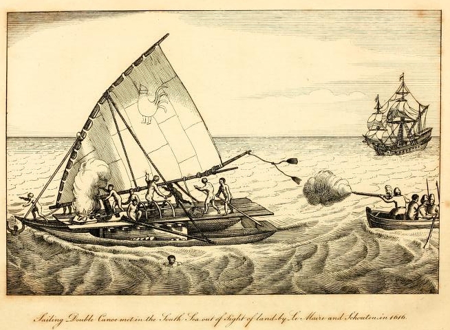
[page] 385
1616. May.
fifteen or sixteen other Indians, rubbing and blacking their faces with cinders, like men who prepared themselves for death, and casting their goods into the sea (which were a number of small mats and some fowls), threw themselves after′* One of these Indians took with him an infant. When the Hollanders entered, it appeared that the Islanders could not have made resistance, for they had no arms. There were found in her two men, one of them very aged, the other was the wounded man, who had returned into the canoe: there were likewise eight women, with several children, three of whom were at the breast; the others were about nine or ten years old. The canoe was taken along side of the ship, and the boat afterwards went to the assistance of the Indians in the water; but, according to the journal of Schouten′s voyage, only two were recovered, who pointed with their fingers to the bottom, to signify that the rest were drowned. The same journal says, ′according to our estimation they had been about 25 persons.′ This number is less than agrees with the preceding statement. The Navigation Australe has endeavoured to palliate the transaction by a less unfavourable representation of the evil committed. ′The women wept,′ says that account, ′because their husbands were drowned, but they were afterwards found again.′ The continuation of the same narrative shows that this was not the fact with respect to all; but it does not appear how many perished.
The men of the canoe were taken into the ship, and such atonement as compassion suggested, the Hollanders were willing to make, by consoling demeanour and by gifts. Dressings were applied to the wounded person, who was a young man with, long yellow hair. Towards evening the men were put into their canoe again, to the unspeakable comfort of the women, who
* Nav. Aust. Le Maire, p. 140
VOL. II. 3 D
[page] 386
1616. May.
′clasped them round the necks,′ and kissed them many times with great marks of affection.
These people were of a yellow or copper complexion. Their clothing was a slight covering round the middle, and some of them had a veil of a thick cloth which served as a shelter against the heat of the sun. The hair of the women was cut short. To show their thankfulness for the presents made them by the President, they gave in return two fine mats and two cocoanuts. Their stock of provisions had been diminished by the loss of their fowls, and now consisted of only a few cocoanuts and yams. They had entirely consumed their stock of fresh water, and had even drunk all the liquor out of their cocoanuts, which shows that they must have been many days at sea. ′We saw them,′ the journals say, ′drink salt water, and likewise give it to their ′children to drink.′ It is to be hoped, and indeed may be supposed, though it is not mentioned, that some assistance in this particular was given to them from the ship.
The vessel navigated by these Islanders was formed of two large and handsome canoes, which were placed parallel and at a convenient distance (the Navigation Australe says a fathom and a half) from each other: in the middle of each canoe, a very broad thick plank of a red coloured wood, and very light, was placed lengthways upon its edge: across the two planks were laid some small beams, and upon the beams a platform of thin planks. The whole was compact and well fastened together. Over one part of the platform was a small shed of matting, under which the women and children remained. There was but one mast and one sail. The mast was fixed in a step towards the fore part of the starboard (right hand) canoe: the sail was of triangular form, and attached to a yard which rested on the upper end of the mast, which was forked for the purpose. The vessel was steered with oars abaft. The sail was of matting, and towards the upper part of it there was marked a figure representing a cock, which
[page] 387
1616. May.
it is probable was intended, like the flags of more civilised and more powerful nations, to denote to what Island or State the canoe belonged. Their cordage was well made; they were provided with hooks for fishing, the back part of which were of stone, and the hook or bearded part of bone, tortoise-shell, or mother-of-pearl. Every thing appertaining to the vessel was neat and well fitted for sea.
The Islanders being again put in possession of their vessel, cast her loose from the ship. At the time of parting, one of the women appeared to be in great affliction, it was supposed lamenting the loss of her husband.* They shaped their course SE, which was in a direction nearly opposite to that in which they were sailing when first seen from the ship It is probable that the events of the day occasioned them to alter their destination.
This unfortunate adventure is the heaviest reproach which can be brought against the Voyage of Le Maire and Schouten, and is the more blamcable as it might have been expected that from a sympathetic regard, independent of general considerations of humanity, they would have respected the enterprising navigators of the South Sea; a character to which these Islanders were well entitled, who, without compass, or any of the aids from science which enable the navigators of other countries to guide themselves with safety, ventured beyond the sight of land.
10th.
Cocos Island.
The 10th, the wind was light from the SE. After breakfast, a high Island was seen bearing SWbS about 8 leagues distant. The course was directed towards it; and in the afternoon another Island was seen to the South of the one first discovered, long and more level in appearance. The ship did not arrive near to the land before dark, and the night was passed upon different
* Navig. Aust. de. Le Maire, p. 140.
[page] 388
1616
May. Cocos Island, 11th.
tacks. Two fishing canoes were seen, which carried, lights, and kept sailing backwards and forwards all night.
The 11th, in the morning, the ship ′stood to the South towards the [high] Island, with the wind at East, and passed over a bank, on which they had soundings from 14 to 26 fathoms depth, the bottom stony with small shells.′* This bank is about two leagues distant from the Island†; its extent is not mentioned, but when they had passed it, they could not get soundings. One of the fishing canoes approached the ship, but would not come alongside. The fishermen spoke much, and held up their fish. Some beads were shewn to them from the ship, and a bucket fastened to a line was veered astern that they might put the fish in; but the fishermen, after a close inspection of the bucket, which was hooped with iron, took it into their canoe, and in exchange for it fastened to the rope two cocoanuts and some flying fish. These vessels sailed fast. One of them carried in her a smaller canoe.
The ship being arrived near the Northern Island, a boat was sent to examine for anchorage. Soundings were found from 12 to 15 fathoms-depth, the bottom shelly (ecueilleux), and the sails of the ship were lowered as preparatory to anchoring. The men in the fishing canoes made signs for the ship to go to the Southern Island, and to mark their meaning more forcibly they directed their canoes towards it. Their advice, however, was not followed, and the ship anchored near the NNW part of the firft Island, at the distance of a good cannon shot from the shore, in 25 fathoms,, the bottom of sand mixed with small shells.
This Island was a high mountain, and in form resembled the Island Terrenate of the Moluccas. It was well covered with trees, the greater part of which were cocoa-nut trees, on which account
* Nav. Aust. de Le Maire, p. 141.
† Merv. Voy. de Schouten, p. 40.
[page break]
[page break]
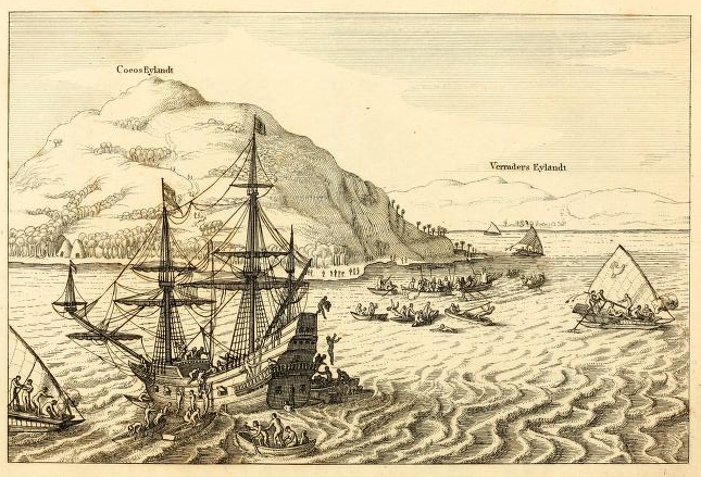
[page] 389
1616
May. Cocos Island.
it was named by the Hollanders Cocos Island. The Island to the South was distant about two leagues from the ship′s anchorage. It appeared to be of greater length than Cocos Island, but not so high.*
As soon as the ship had anchored, three large sailing canoes and several small canoes came near to her. Two of the small canoes put out white flags, in answer to which the same was done by the ship. It was not long before some of the Islanders ventured on board, and the experiment not being found dangerous, the example was quickly followed by all who could get at the ship. One of the Dutch seamen played to them on the fiddle, and his performance obtained much notice. ′Our sailors,′ says the Nav. Aust. de la Maire, ′many of whom were good drolls, began to dance, which the natives also did, showing themselves joyful and delighted beyoud measure, making immediately great acquaintance with us.′ They promised to bring provisions to exchange for nails, beads and cutlery; and that same afternoon, 200 cocoa-nuts, with a quantity of yams, were brought to the ship, which were purchased with nails and beads, four or five cocoa-nuts being received in exchange for a nail or a small bead. But the advantages of this quickly formed intimacy were accompanied with some inconveniences to the Hollanders. Their new companions increased too much in number and in familiarity, and it became difficult to move in the ship for the crowd of visitors, whose admiration of every thing they saw was so strong an incentive with them to pilfer, that it was not possible to guard against all their practices. The nails and bolts of the ship they could not draw; but they stole the balls out of the cannon, the bedding, of the seamen, clothes, and, in short, whatsoever
* Captain Wallis saw these Islands in 1767. According to a chart given of them in the account of that voyage, they are situated NNE and SSW from each other, one league apart, and neither of them exceed three geographical leagues in circuit.
[page] 390
1616.
May. Cocos Island.
they had an opportunity to take. One of the natives snatched a knife out of the cook′s hand by the blade, and cut all his fingers, but nevertheless he jumped overboard without quitting his prize.
The small canoes at this Island carried in general three or four men each. They were made entirely of one piece of a red wood; were low in the fore part, and peaked at the stern, and were paddled with great swiftness. The natives were of large statures and well proportioned in their limbs and body. They wore no clothing except round the middle. Their hair was disposed in a variety of fashions, some among them having it neatly frizzed. Their bodies were marked with blue blackish spots as if burnt with gunpowder, and their ears were slit [fendu] and reached almost to their shoulders.
The anchorage at Cocos Island was much exposed to the sea; for which reason, a boat was sent from the ship to examine if the other Island, which appeared full of people and houses, afforded better shelter The boat had not advanced far before she was surrounded by canoes, which came from the Southern Island, and the Islanders took away the pilot′s lead and boarded the boat, but one of them being killed by a musket shot, the rest fled. The boat did not proceed; and at night was hoisted into the ship as the only certain means of securing her from the attempts of the natives.
12th.
The 12th. Many canoes came early to the ship, with cocoanuts, bananas, yams, and some small hogs; and so eager were the natives to traffic, that those who were in the outer canoes held their goods fast with their teeth, whilst they dived under the other canoes to come at the ship, all of them being excellent swimmers. To prevent confusion and frauds, all the exchanges for provisions were made in the gallery, and delivery was required from the natives before payment, Many for want of other merchandize brought off fresh water in cocoa-nut shells.
[page] 391
May. Cocos Island.
In their admiration at the size of the ship, they were willing to make experiment of its strength, and some of them got near the rudder, where they amused themselves by beating the ship′s bottom with stones.
This forenoon, a danoe came on board from the Southern Island, which brought as a present from the Chief, or King, a young pig, a cock, and a hen. An acknowledgement was offered to the messenger, but he refused to accept any thing, and made signs that the King himself was on his way to the ship. In about an hour after, a large sailing vessel arrived, in which was the Chief, seated under a shed or awning, with several other persons who appeared to be of consequence; but he could only be distinguished from his attendants by the superior degree of respect observed towards him; for he was not more burthene′d with cloaths than the other Islanders. Thirty-five other canoes attended the voyal one. The Chief, as he approached, spoke aloud a short sentence or prayer. This he did three times singly, and at the fourth was joined by all his company as in chorus; at the same time they put their hands over the back of their necks, and bowed their heads, and made other motions which were regarded as so many demonstrations of respect. The Hollanders, on their part, sounded their drums and trumpets in honour of their visitor, who before he entered the ship sent some of his people on board with a present of a fine mat, and a dress ′which was like paper.′ One of these messengers, seeing that the ship was much incommoded by the throng of natives, ordered them away, repeating the word ′Fanou′, and by the-exercise of his authority, he not only cleared the ship of the croud, but made them depart from alongside with their canoes. A present was sent back to the Chief of two yards of linen, a hatchet, and two strings of beads, on receiving which he bowed, and placed the gifts first on his own head, and afterwards on the heads of several of his attendants.
[page] 392
May. Cocos Island.
The King or principal Chief was called by the Islanders Lalou, but whether this was the sovereign title or the family name of the person enjoying the chief authority, does not seem to have been clearly understood by those in the ship. A Vocabulary collected at different Islands in this voyage, gives the word Ariki to signify King in the language of Cocos Island.* Their present visitor however was not the Latou, but his son. After the reciprocal civility of presents had passed, he went on board the ship, and was treated with much distinction. The Hollanders were informed that Latou resided at the Southern Island, and were invited to remove the ship thither, with assurances that they would be supplied there with as much provisions as they wanted. The Navig. Australe de Le Maire mentions oxen in the list of provisions promised by the natives, which must be supposed a misinterpretation; and in the Vocabulary of the Cocos Island language given with that account, there is the word Nifo, the meaning of which is construed to be ′a certain beast which has horns.′
The young Chief and his retinue retired from their visit with ceremonies similar to those with which they approached, and were again saluted with the music of drums and trumpets. In the course of this day a great number of cocoanuts were purchased of the natives: ′there were 85 men on board, and every one had twelve nuts.′†
13th.
The 13th. With the first appearance of day, the natives renewed their visits, and by sun-rise, nearly 50 canoes had arrived at the ship, with hogs, fowls, and fruits for traffic. Soon afterwards a fleet of 23 large sailing canoes approached the ship, and surrounded her on all sides, which to the Hollanders had a
* Ariki has been found by late navigators to have the same signification at the Friendly Iclands. The Vocabulary to the voyage of Le Maire and Schouten, gives the word Latieu signifying King in the language of New Guinea.
† Voyage of Schouten, English translation, p. 41. London1619.
6
[page] 393
May. Cocos Island.
very suspicious appearance; but the Islanders bartered with their provisions, and their demeanour did not betray any symptom of hostility. The average number of men in each of these vessels was about 25, and one of the larger canoes which seemed to command all the others, carried on her sail the figure of a cock in red and grey colours. Some of the natives repeated their former advice for the ship to go to the other Island. The son of the Latou, their visitor the preceding day, came close to the ship in one of the sailing canoes. He was invited on board by the Hollanders, but he declined the invitation. At this time the Islanders began to be very noisy, and seemed to be ranging their canoes in order of battle. Seeing these preparations, the Hollanders began to take up their anchor, The Latou was himself with his fleet, and both he and his son left the large canoes and went into small ones. A drum was then beat in the vessel which the Latou had just quitted, upon which signal, a general loud cry was set up by all the natives present, and an attack was commenced by throwing of stones. The principal vessel of the natives was steered directly against the ship with all the force her sail could give. Little impression was made on the ship by the concussion; but the Island vessel was too weak to support the shock: the double prow was shattered in pieces, and all the persons on board, among whom were some women, were obliged to take to the water and swim to other canoes. The Hollanders being prepared with their cannon and musketry, the assailants were speedily dispersed. It was supposed that the King had assembled his whole force on this occasion, and the number of the Islanders present was computed at above 1000 men. One man among them was quite white.
This treacherous conduct of the Islanders caused the President and Patron to give up all intention of stopping at the other Island, and as soon as the ship was under sail, the course was directed West and WbS, in pursuit of their voyage. When
VOL. II. 3 E
[page] 394
May. Cocos Island.
they had sailed, about four leagues from the Islands, many of the seamen in the ship were desirous to return and take vengeance of the natives for their treachery; but neither the President nor the Patron approved of such proposal.
Verraders island.
The Southernmost of the two Islands was named, on account of the circumstance just related, Verraders Eylandt (the Island of Traitors). It is distant from Cocos Island only one league. From the station where the ship lay at anchor, the Western part was visible, but the Eastern part was concealed by Cocos Island.* Both the accounts give the latitude of Cocos 16° 10′ S.† Its distance from the coast of Peru, or from any of the Islands before discovered, is not set down; butin the charts both of the Merveilleux Voyage and of the Navigation Australe, it is placed 600 German leagues to the West of Honden Island.
14th.
The course was continued to the West, and the next morning (the 14th), land was seen a-head about seven leagues distant. In the hope of obtaining here a supply of fresh water, the new discovery was immediately named Goode Hope Island. It was only two leagues in diameter, but it presented an encouraging prospect of trees and habitations. As the ship approached the land, some canoes went to her, and bartered four flying fish for beads.
A boat was sent to look for anchorage, and soundings werefound at about a musket shot distance from the shore, the depth very irregular, from 20 to 40 fathoms, and the bottom rocky. Whilst the boat was employed in spunding, fourteen canoes surrounded and attempted to board her, butthey were repelled by musketry, and two Islanders were shot. One of them fell overboard immediately on being struck; the other remained, a
* The plate in De Bry which contains a representation of these two Islands has inverted their situations, and makes the Eastern part of Verraders Island appear.
† The situation of Cocos Island will be found in the next chapter.
[page] 395
May. GoodeHope Island.
small time on his seat and wiped the blood with his hand from his breast, and then fell overboard. The rest of the natives were terrified at what they saw, and fled with precipitation towards the shore, calling aloud, Bou! Bou! imitating the report of the muskets, to explain to the people on land what had happened. A canoe afterwards returned from the shore to search for the bodies of the men that were shot.
The surf broke so high against the shore, that landing could not safely be attempted with the ship′s boat. ′This Island is rather mountainous, but not very high. It is entirely a black rock, except the upper part or soil, which is a black earth covered with verdure and cocoa-nut trees.′* A large village stood close to the water-side, and many scattered houses along the shore. It is in latitude 16° S†, and distance from Cocos and Verraders Islands about 30 leagues.
15th:
From the Island of Goode Hope, the course was directed SW, to increase their latitude; for towards the South, says the Journal of Schouten′s voyage, they expected to find the confinent. On the 15th, however, the course was again changed to WbS. The latitude that day at noon was 16° 12′ S.
17th.
The 17th, the wind was NE. In the beginning of this day the course was continued WbS, as before, but in the latter part the course steered was WNW, which alteration was determined upon by the President with the Council. And on account of the diminished state of the provisions and the scarcity of water in the ship, it was agreed that in lieu of breakfasts there should be given daily to each man half a quarter of a pint of Spanish wine.
18th,
The 18th, the wind was from the Westward but variable. The latitude 16° 5′ S. The Journal of the voyage of Schouten relates, ′This day we assembled our grand council, and the
* Merv.Voy. de Schouten, p. 48.
† Nav.Aust. p. 145
[page] 396
1616. May
Master of the ship, Wilhehn Cornelisz Schouten, represented to them that we had already sailed full 1600 leagues from the coast of Peru and Chili, and had not yet discovered the Terra Australis as had been expected, and that if we advanced farther to the West in this latitude, we should undoubtedly ′fall in with the South side of New Guinea, where it was uncertain whether any passage would be found; and if there should not be one, the ship and merchandise would be lost, as it was impossible to return to the East against the constant trade wind. He represented likewise that our stock of provisions remaining was but small, and that we saw no means of recruiting it; for which causes he proposed to them to change the course and sail towards the North, that they might be able to pass by the North of New Guinea to the Moluccas Which counsel, being maturely considered by each person, appeared to be well founded; and it was unanimously, and with one ′voice, concluded to sail to the North to avoid falling to the South of New Guinea. The course was accordingly changed to theNNW.′*
In the Navigation Australe the change of course to the Northward is represented in the following manner: ′On the 18th, the morning was clear and fine. All this day we had the wind from the West and SW. We made our account to be then 1550 leagues from the coast of Peru; and finding no great sea from any part, we supposed that there was land very near about us, or at least towards the South. We had been sailing SWbS; but the wind coming from the West, the Pilot went into the gallery, and wanted to persuade the President to change the course and turn about to the North. And he soon persuaded the Patron (W. Schouten) who would instantly have followed the advice of the Pilot if the "President had not opposed it, and
* Journal du Mero. Voy. de Schouten, p. 48, 49.
[page] 397
1616. May
desired that the course, they were then steering should be continued till noon. The President wished to sail West, to make the reckoning 1600 leagues from Peru before the course should be changed; but this did not please those of the Council, and they determined to sail to the North.′*
The transactions of the two last days (the 17th and 18th) have been brought forward by the editor of the Navigation Aust de le Maire, as subjects of accusation against the Patron; on which account the ′circumstances have been more minutely attended to than their importance in other respects would have made necessary. The preface to the Nav. Aust. alleges, that by the opposition of the Patron to the designs of the President, the discovery of the Southern Continent was prevented; and that the Patron expended the wine uselessly, and was not careful of the provisions, as if designedly to prevent the success of the voyage.
If blame is attached to their not finding the Terra Australis, little ean be said in exculpation of Le Maire more than of Schouten; for if the discovery of a Southern Continent had been one of the primary objects of their undertaking, they ought to have made their track across the South Sea, in a higher South latitude than they did: but the fact is, they did not, with respect to the Southern Continent, aim higher than to find what had been before discovered. They appear to have had no knowledge that a passage Westward was found by Torres to the South of New Guinea; but their knowledge of the discoveries of Quiros was sufficient to show, that they might have continued on a West course till they had made his Australia del Espiritu Santo, T without any risk of their not being able afterwards to clear the land of New Guinea. It is not pretended, however, that such a determinate plan was proposed by Le Maire, or by any other
* Navig. Aust, de le Maire, p. 145, 146.
[page] 398
1616. May.
person in the ship; and the extent of Le Maire′s wishes, as stated 1616. in the Navigation Australe, was, the completing his reckoning to 1600 leagues from the coast of Peru, in the latitude they then were, as was the case with the reckoning of Schouten. If the 50 leagues wanting had been sailed, they would still have been far short of the Australia of Quiros.
The track which was followed, however, is justified by the design of their undertaking. The Moluccas and the East Indies were the markets to which they looked for their returns. The Australia, if they had found it, could not have been claimed as their own discovery, and their force was not calculated to form establishments. The greatest benefit they could have expected by going there, was a supply of provisions.
The other head of accusation, of negligence and waste in the issue of the provisions, appears still more unreasonable. It is natural enough, and not uncommon in the economy of mercantile expeditions, to find the commander more anxious that his ship′s crew shall have a sufficient allowance of food (they being his fellow-labourers, and the victualling not being at his expence) than the merchant. But this accusation against Schouten is no where made, except in the preface of the Navigation Australe; and the Journal itself does not furnish any fact in its support: for the very moderate quantity of wine that was issued in a time of scarcity, cannot be regarded as waste. The truth seems to be, that the asperity with which W. Schouten is treated in the preface to the Nav. Aust. was produced by the preference claimed for him in the prior publication, and not by any disagreement which happened between him and Jacob Le Maire during the voyage.
19th.
The 19th, they had light winds, with which they steered North. At noon, the latitude was very near 15° S.* After
* Navig. Aust. p. 146.
[page] 399
1616. May. Islands discoveres.
dinner, a breeze sprung up from the South, and towards evening two Islands were discovered, ′of reasonable height,′ bearing NEbE*, distant from the ship about 8 leagues; and from each other, as estimated by appearances, about a cannon shot. The discovered, ship′s course was directed towards the land, but the winds proving light and variable, and mostly from the NE, prevented them from getting near before the 21 st. At noon on that day, the ship was about a league distant from the land. The border near the shore was a white sand, but full of cocoa-nut trees; the inland parts were mountainous. Many canoes came off to the ship from both the Islands, making a great halloo-ing as they approached, which the Hollanders supposed was meant as a salutation of welcome, and they answered it with a similar shouting, and with trumpets. These Islanders resembled in appearance the people of Goodc Hope Island. They exchanged a few small fish for beads and nails; but one of them made threatening motions with a spear, and others came under the gallery, from which, unluckily, a shirt belonging to the President was hanging to dry, which was a temptation they were little inclined to resist, and the shirt was taken away. The merchant Claesz discovering the theft, made signs to them to bring back the shirt; but they answered his signs by throwing stones at him, and he was content to revenge himself upon them in the same manner. Some of the seamen, however, took the alarm, and without direction being given from any superior, fired a cannon and some muskets among the canoes. Two of the Islanders were wounded, and they all fled, throwing the shirt into the sea. It was not long after this quarrel before other canoes came to the ship.
No soundings had been obtained; a boat therefore was sent to sound nearer to the land, but no bottom was found.
* The Navig. Australe says NEbN.
[page] 400
1616. May. At the Horne Islands.
As the boat returned, she was surrounded and attacked by the natives in their canoes, and the attack was repelled with musketry, by which six Islanders lost their lives, and others were wounded, and one of the canoes taken. No anchorage was found in the course of this day; and during the night the ship kept on different tacks near the Island.
22d
The 22d, early in the morning, the ship was near and ′opposite to the middle of the Island,′ but which of the two Islands is meant is not particularised in either of the Journals. The boat was again sent to look for anchorage, and soundings were found at 50 fathoms depth, about the distance of a cannon shot from the land, and the depth decreasing towards the shore. Soon after, the ship anchored in 35 fathoms, on a rocky bottom, and the Patron went with the boats to search for a better anchoring place. His search was successful; for near to the place where the ship lay was found a small bay or gulf, with a clear entrance, and from a valley at the head of the bay, a small river ran into the sea. The ship was got under sail, and anchored again at the entrance of the bay, the wind not being fair for sailing in.
The quarrels of the preceding day did not deter canoes from coming to the ship on this; but the natives were not admitted within the ship. They brought cocoa-nuts, yams, some flying fish, and a few hogs to sell, and they abstained all this day from any attempt which could give molestation or offence. A musket which went off by accident created a temporary alarm, aud perhaps helped to confirm them in their good resolutions. In the marketting of this day, two hogs were purchased, dressed according to the Island mode of cookery, and according to the description in the Navigation Australe, were half roasted and half raw. The entrails had been taken out, and in their place herbs had been put in and hot stones to roast the inside. A live hog of moderate size was brought on board by two old men
6
[page break]
[page break]

[page] 401
1616. May. Horne Islands.
in a canoe, and was supposed to be a present sent by the Chief. Some natives came likewise to the ship, bringing on their heads with much solemnity the roots of a plant, by them called Kava. When they arrived near, they bowed their heads, and placed the Kava on their necks, whilst one of their company made an harangue, at the close of which the rest joined in a loud acclamation. This root they chewed much, but were careful not to swallow it. The inner part of the bay was examined, and found to have good depth of water for the ship; but moving thither was deferred to the next day. This day was productive of much satisfaction to the Hollanders, and passed without any quarrel between them and the natives; and it was regarded as a favourable prognostic of their future intercourse, that some women came in a small canoe to look at the ship. The carved images in the stern much attracted their admiration, and they were complimented from on board with the music of violins and trumpets.
23d.
The 23d. The ship was warped (drawn with ropes) within the bay, and moored head and stern with four cables, in nine fathoms, a rocky bottom, about a stone′s throw from the shore, and right before the stream of fresh water which descended from the mountains and through the valley, so that their boats in watering could be protected by the ship′s guns. The Navigation Australe relates ′the Patron was so much pleased with the place, that he exclaimed, " this is the true Terra Austra lis, seeing that here such abundance of good things are to be got," and he proposed that they should remain in this port five weeks.′
The inhabitants flocked from all parts of the Island to the harbour, the greater number for purposes of traffic, or to satisfy curiosity; but about 500 men armed with clubs and staves assembled near an open house or shed (called a Belay) on one side of the harbour, in which, as appeared afterwards, was the
VOL, II. 3 F
[page] 402
1616. May. Horne Islands.
King, or Ariki (which was here as at Cocos Island the title of the sovereign), and most of the principal people of the Island. In the course of the day many canoes went to the ship with provisions to barter, some of them carrying branches of trees and white flags. In the evening, an old man was sent to the ship with a present from the Ariki of four small bunches of cocoa-nuts, which had been stripped of the outer rind. He would not accept any thing in return, and made invitations to the Hollanders to go on shore; in answer to which he was informed that the invitation would not be complied with unless some persons from the shore remained at the same time on board the ship as hostages.
24th.
The 24th, in the morning, in consequence of the proposal of the evening before, six natives arrived from the shore, who were received as hostages; and the merchant Adrien Claesz, his assistant René Simonson, and Cornelis Schouten the young cabin boy, went on shore. The native hostages were persons of distinction, and were entertained as such: two of them were young men who accompanied their fathers, and were remarked for being ′the most handsome, the most graceful, and with countenances the most spirited that one could desire to see.′
The merchant Claesz was received on shore with great honours. He found the Ariki seated on a mat under the Belay. When Claesz first approached, the Ariki with his hands joined, bowed his face towards the ground, and in that attitude he continued nearly half an hour, the latter part of the time with evident marks of perplexity. It is probable he would have remained so much longer, if Claesz had not recollected himself, and begun to return in the same manner the marks of respect shewn to him. The Ariki then resumed his. natural position. Another person who sat near the Ariki, and was supposed to be of great quality, saluted the feet and hands of the merchant, ′sobbing and crying like a child, putting the foot of Adrien Claesz upon
[page] 403
1616. May. Horne Islands.
′his neck, and making him sit upon a mat, whilst himself sat upon the bare earth,′*
A present was delivered by Claesz to the Chief, consisting of two large hand-bells, a red bonnet, some knives, beads and looking glasses. They were received with much approbation, which was expressed by frequent repetitions of the word Awoo. The shirt worn by Claesz was much admired for its whiteness, and no less desired; he therefore sent to the ship for a shirt to add to the other gifts. The Ariki made in return a present of four hogs; and on understanding that it was intended to take here a supply of fresh water for the ship, he gave orders for some of his people to attend at the river to keep the place clear of the natives, that the waterers might not meet with any interruption. He was very inquisitive about fire arms, and desired that one of the ship′s cannon should be fired, notice of which was sent on board; but-notwithstanding the previous knowledge the natives had of what was to be done, and their endeavour to be collected, when the gun was fired, they all fled from the shore into the woods, the Ariki himself not excepted; they soon, however, recovered from their surprise and came back. Before the return of Claesz to the ship, the hostages on board began to show uneasiness at their confinement, although the President endeavoured to amuse or employ them, with music, dancing, and by collecting from them words of their language, which he wrote down.
During this time, the canoes of the natives thronged about the ship, and in many of them were women and children. One of the natives found an opportunity to steal a sword out of the cabin, with which he escaped to the shore; but an attendant of the Ariki being made acquainted with the robbery, he immediately dispatched people in pursuit, who soon brought back
* Navig. Aust. de Le Maire, p. 149.
3 F 2
[page] 404
1616. May. Horne Islands.
both the sword and the thief. The culprit was beaten, and it was signified to the Hollanders that his head would have been cut off if the Ariki had been informed of the fact. ′After this adventure,′ says the Journal clu Merveilleux Voyage, we never ′discovered that any thing was stolen from us either on shore or at the ship.′
About noon, the hostages were released on each side.
25th.
The 25th. There was this day a free communication with the shore, and it was not thought necessary by either side to require hostages. Hogs were not found to be in such plenty as had been at first imagined, and very few were procured. Vegetable provisions were brought in great plenty, and more cocoa-nuts were offered for sale than were wanted.
26th.
The 26th. In the morning the President went on shore, and with some degree of state, taking with him a trumpeter, and an assortment of European goods as a present for the King. He was treated by his Majesty with many marks of respect and ceremonies, of the same kind as had before been shown to Claesz. Some fruits were brought, among which were citrons; and a beverage of the Kava root was prepared, of which the following account is given. The operators began by washing their hands: they then chewed a quantity of the root very small, and taking it out of their mouths, put it all together in a large trough or platter of wood, and poured water on it. It was then stirred about and squeezed, and finally the liquor was strained through a kind of tow*, and served to each of the company in cups formed of leaves rolled or twisted.
The early accounts of this voyage are much to be commended for the intelligible plainness of their narrative, in which much regard for veracity is visible. In a few particular instances, nevertheless, the journalists have been ambitious of imitating
* Merv. Voy. de Schouten, p. 58. And Navig. Aust.. P.151.
[page] 405
1616. May. Horne Islands.
or rivalling the wonders of other European navigators, their predecessors. An example of this kind is about to appear. The Ariki and his son took a head-dress made with feathers from their heads, and put them on the heads of Le Maire and Islands-Adrien Claesz. The journalist, in a spirit of close imitation, construed this to be a regal investiture, and has related it in the following terms. ′The Kings, took off their crowns and put them on the heads of our two Merchants, crowning them King and Viceroy of the Island, as if for a recompense of their great labour, care, and diligence, in having undertaken and performed so painful a navigation.′* This was rather too much, gratitude for so small an obligation.
In the evening the seine was drawn on shore, and, among other fish, were caught two ′very large in the body and head, having spots on the skin like a sparrow hawk; the eyes entirely white; and with two great fins as long as the tail of a ray, and between these fins was the tail, very slender. Their forms had some resemblance to those of bats.′†
The ship′s boats were employed during the whole of the day in carrying fresh water on board.
27th′.
The 27th. This day, like the preceding, the Hollanders were employed in watering and bartering for provisions. In the evening some fish were caught, and a part of them were sent as a present to the Ariki, who accepted them with great willingness, and immediately began to eat them raw; ′heads, tails, entrails, and all with good appetite.′ Some of the Hollanders, in full confidence of the friendly dispositions of the natives, remained on shore among them, dancing by the light of the moon, singing and playing on instruments. The natives also, danced to the sound of their drums, ′which was a sight pleasant to behold: and to add to the diversion of the evening,
* Nav. Aust. de Le Maire, p. 152.
† Ibid.
[page] 406
1616. May. Horne Islands.
the merchant, Adrien Claesz, and another of his countrymen, acted a mock fight with swords, an exhibition which was regarded with admiration by the Islanders.
28th.
The 28th, the watering was completed, and the Patron, W. Schouten, went on shore attended by the trumpeters, and visited the Ariki. This day likewise the Chief or Ariki of the other Island came to visit the Ariki of this, and to see the strange people. The meeting of the two Chiefs was in the extreme ceremonious; the particulars are not described; but those are of another meeting, which shortly after took place. The first ceremonies, which were accompanied on each side with presents, being concluded, the visiting Chief appeared to speak in the language of complaint and reproach, and grew loud; the cause of which was suspected by the Hollanders, some of whom were present, to be a desire to attack the ship, and a refusal on the part of the other Chief to join in such an enterprise.
The distinctions of rank and degrees of subordination established among these people, could not possibly be comprehended by the Hollanders who were ignorant of the language from the little they saw in the short time they remained at the Island. The accounts given concerning some of these particulars are accordingly confused and contradictory. The newly arrived Chief had a greater number of attendants, and though he was but the son of a King, seemed to have more authority and magnificence than the Chief he came to visit.′* In the afternoon, the President went on shore to pay his respects to the two Arikis, and was present at a Kava feast. ′As many of the roots were brought as would have made a bulwark round them; and this it seems is the manner in which the Chiefs welcome each other.′ When the Kava drinking finished, the royal guest retired, and returned to his own
* Merveilleux Voyage, p. 152.
[page] 407
1616. May. Horne Islands.
Island, with the intention, as it afterwards appeared, of making soon another visit in greater state.
29th.
The 29th. This morning, the President, with Claesz, and two other persons of the ship, walked to some mountains inland, a son and a brother of the Ariki going with, them as guides and safeguards. They passed through some valleys, which the rains and waters descending from the mountains had rendered naked and barren, and saw nothing worth noticing except a red earth, which the natives use as paint, and some caverns in the sides of the mountains that, occasionally in times of war were used as hiding places.
At noon they returned from their walk, and the friendly guides went on board with the President. The King′s son, who in the Journals is sometimes called the Viceroy, went to the topmast head, and to all parts of the ship, and examined many things with much attention. Afterwards, whilst they were at dinner with the President and the Patron, they were informed that as much fresh water had been taken on board as was wanted, and that if a supply of ten hogs and some yams could be obtained, the ship would depart in two days. As soon, as this communication was understood, the Viceroy sprung from his seat, and ran to the gallery, from whence, in a loud voice, and with marks of great satisfaction, he announced to all the natives within hearing, that the ship would leave their Island in two days.
The first appearance of the Hollanders naturally filled the Islanders with wonder, which, from what had been experienced of their power, would not be unmixed with alarm. This state of apprehension appears to have been increased by the quantity of
* In the Journal du Merveilleux Voyage de Schouten, it is said ′comme nousestions assis au table nous leur fismes signe′—(as we were seated at table we made signs to them)—; wliich method of expression indicates that the writer of that Journal was one of the company then present.
[page] 408
1616. May. Horne Islands.
provisions drawn from the Island by the ship. Certain it is, they rejoiced heartily at the prospect of a speedy separation from their new friends, and the Viceroy immediately promised that ten hogs and other provisions should be brought to the ship on condition that she should sail at the time specified.
In the afternoon the Ariki himself went on board the ship, attended by sixteen of the principal Islanders. This Chief was a man of good appearance, and supposed to be about 60 years of age. He brought as a complimentary present a pig and a basket of cocoa-nuts, and when he entered the ship, he put them on his neck, and prostrating himself, laid them before the President, who raised him up and seated him on a cushion. The Ariki then commanded his attendants to take the President and the merchant Claesz upon their shoulders, in which state of honour they remained a short time, till by the Chief′s command they were set down with much formality and reverence. Le Maire acknowledged these honours with handsome presents and entertainment, and showed his guest the wonders of the ship: after which he accompanied him to the shore.
The President afterwards walked with the Viceroy to see thè country and the habitations; and at a village a small distance from the landing place, he found the inhabitants, both male and female, very joyously engaged in dancing with some of the Dutch seamen. One of the Journals remarks, ′we were there as free and friendly as if we had been at home in our own houses.′ Towards evening, the Hollanders returned to their ship. At night, Adrien Claesz went in a boat with a small party to fish, and having been successful, they landed to carry a share of what they had caught to the Ariki. When they came to the Belay, they found the old Chief with a company of handsome young girls, naked, dancing before him to music made by beating on a piece of wood hollowed in the manner of a pump. To this instrument, they danced ′very excellently, with very
11
[page] 409
1616. May. Horne Islands.
′good grace, and observing the measure of the music.′ The Hollanders, never averse to this diversion, joined in the dance, which greatly diverted the Ariki. Unluckily, during the entertainment, some of the fish were stolen, at which the Chief was Islands, much enraged, and beat two of his subjects, who were found to be the guilty persons, so severely, that he almost killed them. The night was far advanced before the Hollanders retired to their ship.
30th.
The 30th. At breakfast time, a canoe brought two hogs to the ship as a present from the Ariki, and many of the natives carried off presents of fruits and vegetables to the ship, on account of her approaching departure. The Viceroy dined on board; and soon after dinner, a number of canoes were seen coming from the neighbouring Island towards the Island where the ship lay. In these canoes were the Ariki of the other Island, and a large company of his people of both sexes. The principal persons among them were dressed with fine mats, and there were at least 300 men who had each a band round his waist of ′a green plant of which they make their drink.′
While the canoes were yet at a distance, but had arrived within hearing, the two Arikis began making lowly reverences to each other, the one on shore having advanced to the sea side to receive his visitor; and these actions were accompanied on both sides by speeches uttered with much apparent fervour. Upon landing, both the Arikis prostrated themselves several times on the ground with their arms extended forwards, sometimes towards each other, sometimes towards the canoes, and sometimes towards the river; the people by which each was attended holding themselves in the meantime in respectful and humble attitudes. ′After much ado, both the Arikis rose up on their feet, and went and sat down together under the Belay
VOL. II. 3 G
[page] 410
1616. May. Horne Islands.
or shed, and there they sung or chanted a kind of song which is called Adoua.
A circumstance not less strange than the extreme degree of ceremony observed among a people so uncultivated, is, that a greater personage than either of the Arikis was present. The Navigation Australe relates, ′there was likewise here the Great Orankey or Superior of the two Islands.′ It is before said that one of the Arikis was only the son of a King. The King alluded to was probably the Orankey. All that we read of him afterwards, is, that ′one of the Arikis recommended to the Great King to go and see the ship; but he did not dare to venture on board.′
Claesz was on shore at the meeting of the Arikis; and soon after, the President with others of the Hollanders landed; and, not to be neglectful of state where it was so much regarded, they came attended by four trumpeters and a drum. When they arrived near the Belay, the instruments were all sounded together, which produced great satisfaction, and the President was complimented with a mat to sit on near the Arikis.
′A troop of the country people of the smallest Island then came near the King, who brought with them a quantity of a green herb which they call Kava, such as was worn by the 300 men before mentioned.′* Of this a beverage was made in the usual manner, and portions of it served to the Arikis and the principal Islanders. The Hollanders were invited to partake, but they were satisfied with the sight only of the brewing.
The hospitality of the Islanders was magnificently displayed at this meeting of the Chiefs.* Sixteen roasted hogs and a large
* Merveilleux Voyage de Schouten, p. 58. From this paragraph, it seems reasonable to infer that the 300 men came from the large Island, and consequently that the ship had anchored at the smallest Island.
[page] 411
1616. May. Horne Islands.
quantity of dressed yams were served up. The Arikis, each with great ceremony, presented a roasted hog to the Hollanders, many of whom had come on shore, and the pork did not, like the Kava, court their acceptance in vain, though the cookery did Islands, not escape criticism. When the Arikis, ′the nobles and gentlewomen′ were served, the remainder was distributed among the rest of the company who were seated so as to form a ring on the outside of the Belay; and it was estimated that the number of persons present were not less than 900.
During this entertainment, eleven hogs, rather undersized, were delivered by the Arikis as a present to the Hollanders, who made a present in return, of a hatchet, some copper basons, knives, nails, and beads. These things, the Chiefs distributed among those of their people to whom the hogs had in reality belonged. In the evening the Hollanders returned on board, pleased with their entertainment, and contented that the engagement of the Viceroy was now fulfilled.
The 31st. Early in the morning the ship began to take up her anchors and to make preparation for sailing. After breakfast, the two Arikis and many of the natives went on board, the principal persons among them wearing green leaves of the cocoa-nut tree round their necks, which probably was a ceremony usual at the parting of friends. The Arikis brought with them a present of six hogs, aud the natives, to make the most of the last day of the market, brought yams bananas and cocoa-nuts in great plenty to traffic, so that the ship made good provision. The Chiefs and their attendants were entertained on board with wine. The portrait of the Prince of Orange was exhibited to them, as representing the Ariki of the Hollanders. A map of the World was likewise shown and some explanations attempted. Presents of various European articles were made to the Arikis, and to each of their followers a nail was given. When the Arikis left the ship, Le Maire went on shore with them, and more
3 G 2
[page] 412
1616. May. Horne Islands.
mutual presents accompanied the last adieus. At noon the ship sailed, and the Hollanders and Islanders separated; content With each other, yet to Part.
These two Islands were named by the Hollanders Horne or Hoorn Islands, in honour of the birth place of the Patron; and the Bay in which they anchored was named, after the ship, Ecndracht Bay. It is said in the Navigation Australe, that the President Le Maire believed these Islands and Goode Hope Island were the Salomon Islands of Mendana.
The Natives described The Men.
In relating the transactions at the Horne Islands, the Dutch Journals have endeavoured to heighten whatever appeared ludicrous or strange. The Journal du Merveilleux Voyage, nevertheless, describes the men of these Islands to be valiant, well made, strong, and active. They were good runners, expert swimmers and divers. They exceeded the Hollanders in stature, the men of common size amongst them being as tall as the tallest people of the ships. Their colour was between yellow and brown: they were neat and formal in the dressing their hair, which was done in various fashions, some of which appear to have been established marks of distinction. The Ariki had his hair collected into one thick twisted rope on the left side of the head, from whence it hung down as low as the knee. The persons next in consequence had two tails, one on each side. Some had four or five tails, and some had their hair frizzed so as to stand erect like hog′s bristles. On particular occasions, the superior people wore dresses made of fine matting, and the great pains taken with their hair can be supposed no other than an occasional piece of finery. In general no dress was worn by the natives of either sex except a small covering round the middle. Another symbol of distinction, remarked only among the persons who were near the Ariki, and were supposed to be of his Council, was the having a favourite pigeon, which they carried on a perch.
5
[page] 413
Horne Islands. The Women.
Both the accounts join in dispraise of the women, giving them the character of being little, and deformed, both in body and countenance. A sample which has been given in a drawing that accompanies the original accounts, is made to correspond with this description; but the representation cannot be admitted just, if generally applied. It will require clear proof to establish that there exists a greater disparity between the male and female of the human species at the Home Islands than has been seen in any other part of the world. It is not improbable that the natives, who did not wish to encourage the Hollanders to stay at their Island, might have taken the precaution to keep the most tempting objects out of their sight. Those who danced before the Ariki, the sight of whom the Hollanders obtained by accident, were allowed to be belles jeunes filles. The women are likewise much censured for want of modesty. To attempt to defend them from this charge would probably be a much more perilous undertaking, than to be the champion of their beauty.
The Journalists have gone beyond their knowledge in saying that these Islanders lived without labour, that they neither sowed ner reaped, and that they were without religion. The Merveilleux Voyage indeed speaks concerning the latter article with some caution, ′we did not observe that these people had any God or Divine Service.′ Both the Journals however assert, in an unqualified manner, that they did not cultivate the soil; but in this, there can be no doubt that they were mistaken, and that they judged of the whole Island by the small part which came within their observation.
Habitations
The houses of the natives were of a form nearly conical, except that the top was rounded; the outside was a thatching of leaves; the dimensions (of those seen by the Hollanders) were very small, the whole circumference being about twenty-five feet, and the height ten or twelve feet; the door was so low
[page] 414
1616. May. Horne Islands.
that it could not be entered without stooping. The only furniture or goods seen within the houses were, dry grass to sleep on; fishing tackle; and in some of the houses a wooden club. From this account it may be concluded that the land round Eendracht Bay in which the ship anchored, was a very thinly inhabited part of the Island.
Eendracht Bay
Eendracht Bay, the Merveilleux Voyage says, ′lies on the South side of the Island,′ but whether of the Northern or the Southern Island is not expressed in direct terms. It may be collected from the narrative, that the Island at which the ship anchored was the inferior Island; and in the chart to the Navigation Australe the track is drawn evidently pointing to the Southern (which is the smaller) Island as the place of stoppage.*
The latitude of Eendracht Bay is in both the Journals set down 14° 56′ S. The ship′s latitude given on May the 19th, the day they first made the Home Islands, and likewise the latitude as they sailed away (on June the 1st), give each a more Northern situatìon to the Islands than the latitude above- mentioned.†
The anchoring ground in this Bay was on a bottom of sharp rocks, by which their cables were cut, and they left two anchors behind. ′On one side of the Bay there is a bank of sand and rocks, which is dry at low water: on the other side was firm
* This is in some degree discountenanced by what has been seen in a late voyage. In 1801, Captain William Wilson, in the British ship the Royal Admiral, fell in with the Horne Islands. He found a Bay on the South side of the Northern Island, answering in appearance to the anchorage of Le Maire and Schouten, and which in a MS. chart of the Islands drawn in that voyage is marked Schouteu′s Bay. The Southern Island does not appear to have been examined in the Royal Admiral. This voyage by Captain Wilson, I am informed, is preparing for the press, and that it will communicate several new and important discoveries.
† The situation of the Horne Islands, as observed by Captain Wilson, is from 14° 13′ to 14° 23′ S, latitude, and from 178° 11′ to 178" 26′ W longitude from Greenwich.
[page] 415
1616. May. Horne Islands.
′land (terre ferme), but the shore was likewise rocky.′* The meaning of terre ferme here, is not clear; but it seems to have been intended to express that the bottom was regular and free from rocks.
The ship was moored about a musket shot distant from the fresh water river, in 10 fathoms depth, where the bay or inlet was so narrow that it did not afford room for the ship to swing or turn round, and she was therefore, as before noticed, moored head and stern.
In the charts, the two Islands are placed about NNW and SSE from each other†, and in longitude from Cocos Island nearly five degrees West; which, according to the mode of reckoning adopted by Schouten, will give 1600 German leagues from the coast of Peru.
On leaving Eendracht Bay, the ship sailed all the afternoon and part of the evening, to the WSW and West, to get clear from being becalmed by the Islands. Afterwards they steered towards the North.
June.
June the 1st. In the morning, the Home Islands were still in sight bearing SSE. At noon the latitude, according to the Merveilleux Voyage de Schouten, was 13° 15′ S; by the Navig. Aust. 13° 40′ S.
2d.
The 2d, they steered NbW, and on the succeeding days the course was gradually directed more Westerly; the Merveilleux Voyage says, ′the greater part of the time NWbW.′ According to the track in the chart, the course between June the 2d and 6th appears to have been towards the WSW; but nothing to that purpose is said in the Journals.
6th.
The 6th. On a consultation held between the President, the Patron, and the Pilots, the course, by their common consent, was again directed North, that they might more speedily
* Merveilleux Voyager, p. 61.
† Captain Wilson places them NWbW and SEbE from each other.
[page] 416
1616. June.
ascertain if they should clear the Eastern part of New Guinea. At noon, latitude 11° S. In the Recueil des Voyages a l′etablissement de la Compagnie, this consultation is mentioned in such a manner as to appear to have been held on the 3d; but there seems, to have been a date omitted. The Recueil says the course was changed to NbW; and that on examining the reckonings, it appeared that their distance from the coast of Peru, was,
| According to the reckoning of the Patron | 1730 leagues. |
| of the first Pilot | 1665 |
| of Jac. Dirrick | 1655 |
| of Corneille, the 2d Pilot | 1610 |
| of Koen Dirrick | 1640 |
| and taking the mean, gave for the distance from the coast of Peru | 1660 leagues.* |
These particulars concerning the reckoning are the most material of the information which the account in the Recueil a l′Etablissement de la Compagnie has added to what was before published. The distances require a later date, and the narrative of the Navigation Australe supplies the 6th.
13th.
The 13th. They were 155 leagues to the West of the Home Islands, †
14th
The 14th. The latitude was 3° 45′ S. Many birds were, seen. The course was directed between the West and WSW. A high sea from the SSE convinced them that they had not yet passed the Eastern part of New Guinea.
20th. A Groupe of Islands. 21st.
The 20th. The latitude was 4° 50′ S. Wind NE. Course West. In the evening, land was seen to the Southward.‡ The night was passed ′without sails.′ In the morning of the 21st, they made sail towards the land, which proved to be a cluster
* Rec. a I′Etab. de la Comp. Vol. 8. p. 190.
† Ibid. p. 191.
‡ The Navig. Aust. says with high hills; but in the next day′s remarks, the same journal describes this land to be very low.
[page] 417
1616. June.
of small low Islands, according to the Navigation Australe, six in number, connected by reefs or sand banks, some of which extended far out from the Islands (the distance or extent is not otherwise expressed) towards the North and NW. These Islands were covered with trees. The ship sailed by the North of the reefs, and when past them, two canoes came to her, one with six men, the other with four, all armed with bows and arrows; and they were the first Islanders who were found with bows and arrows in the course of this voyage. They were marked with the tattow, and in language and appearance they much resembled the inhabitants of the Home Islands, excepting that they were of a darker complexion. The same difference of complexion may be generally remarked throughout the South Sea, between the inhabitants of the large Islands and those of the small low Islands; occasioned by a greater exposure to the heat of the sun.
Some small presents were made to the people in the canoes, who had nothing to give in return, which they signified by the words Ajouta ne ay; but they pointed towards the West, where they said their King lived, on Avhose land there was plenty of every thing. None of them would venture within the ship. No anchoring ground was found. At noon the latitude was 4° 47′ S. The ship sailed on to the West. No name is given, in either of the accounts, to these Islands.
22d.
The 22d. They had a good breeze all day from the ESE. The course was West and at times W b N. Latitude at noon 4° 45′ S. Towards evening land was seen to the WSW, which was found to be a groupe of 12 or 13 small low Islands, so near Marquen. to each other that their extent from NE to SW was estimated to be only a league and a half. The ship passed to the North of them, and was obliged to make a small circuit ′to avoid two
′small clumps of trees which stood in the water.′ The President named this groupe Marquen, after a place which it was thought
VOL. II. 3 H
[page] 418
1616. June.
to resemble. It was distant from the Islands seen the preceding day 32 leagues.* No current was observable.†
24th. Groene Islands.
The 24th. The wind was from the Southward. At noon, the latitude.was observed 4° 25′ South, and at the same time land was discovered to the SW, which from the mast head was seen to be three Islands, the Navigation Australe says, one high and two low. The Journal of Schionten′s Voyage says, ′they were three low Islands, green, and full of trees; two of them were two good leagues in length, but the third was small. Their shores were of hard rocks, and we could not find good ground for anchoring.′‡ They were named Groene Islands. Their distance from the Marquen groupe is not mentioned in the narrative, but by the charts appears to be about 32 German leagues. §
Island of St. Jans
The ship passed to the North of the Groene Islands; and the same afternoon a high Island was seen before them bearing WbN, on which were seven or eight hillocks. This was named St. Jan′s Island.§ Its distance from the Groene Islands is said in the Navigation Australe to be about l5 leagues; but in the
* Navig. Australe.
† Rec. a l′Etabt. de la Comp. Vol. VIII. p. 192.
‡ Merveilleux Voyage, p. 63.
§ The Groene islands were seen in 1767, by Captain Carteret, who passed to the South of them in the night, without seeing that they were separate, and taking them for one Island, named them Sir Charles Hardy′s Island. SEE Hawkesw. Coll. Vol. I. p. 587. Captain Hunter likewise was in sight and to the South of them, but it was very early in the morning, so that he had run past them before daylight, and he has mentioned them as a single Island. Captain Hunter gives their situation in latitude 40 41′ S. Longitude 154° 30′ E. from Greenwich. Capt. Hunter′s Hist. Journal of Transactions in New South Wales, p. 224.
§ The Island of St. Jan has been identified by Dampier and by Carteret, each of whom has given a drawing of its appearance, as likewise have other navigators; and they all agree with the description above, which is copied from the Journal du Voyage de Schouten. See Dampier, Vol. III. Tab. xi. fronting p. 167. 3d Edit. And Vol. I. of Hawkesworth′s Collection, Plate fronting p. 588.
[page break]
[page break]
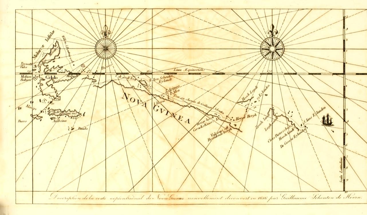
[page] 419
1616. June.
charts to both the Journals it is placed not more than half that distance from the Groene Islands.*
The night was passed standing backwards and forwards between the Island St. Jan and the Groene Islands.
25th. Land discovered, supposed to be the East Cape of NewGuinca
The 25th. In the morning the wind was not fair for approaching St. Jan′s Island, and they ′saw before them to the SW other land marvellously high, which was believed to be the posed to be the Cape of New Guinea.′† They stood towards this newly discovered land, and by noon were near enough to see habitations New-Guinea and people on the shores. Soundings were tried, but no bottom was found fit for anchorage.
In the Journal′du Voyage de Schouten it is said that this land was according to their estimation distant from the coast of Peru 1840 German leagues; but the chart of the track in that journal shows the number to be erroneously printed, the difference between the meridians of this land and of Lima being laid down 126 degrees, which, as the chart is constructed on a plane projection, is equal to 1890 German leagues.‡
Sail along the North Coast.
The ship′s course was directed along, the coast (towards the NW) with the wind from the ESE. The land near the coast abounded with fine cocoa-nut trees, and on the mountains were seen great smokes. The ship′s boat was kept out sailing and sounding along the shore between the ship and the land. Two
* The chart of New Britain to Captain Carteret′s Voyage (Hawkesworth, Vol. I. fronting p. 595) agrees with this latter distance, St. John′s Island being there laid down WbN, about 10 geographical leagues from Sir Charles Hardy′s Island.
†′ Voyage de Schouten, p. 63. The land here discovered is the East Cape of the land at present known by the name of New Ireland.
‡ Mr. Dalrymple detected the error above noticed. SEE his Historical Collection of Discoveries, Vol. II. p. 64. The figures in the charts to the early editions of the Voyage de Schouten are in the Italic or Manuscript character; and the fours have the last stroke curved in such a manner as to render the four and nine liable to be mistaken for each other.
3 H 2
[page] 420
1616. June.
Anchor in a Bay.
canoes put off from the shore, for no other purpose than to attack the boat, which they did with stones thrown from slings; but on their salutation being returned with musketry, they hastily retreated. The boat did not obtain soundings here. The land along which the ship sailed afforded a pleasing prospect, and many parts appeared to be cultivated. No soundings were obtained by the boat. In the evening, however, the ship came to a small Bay, in which she anchored about a cannon shot distant from the land, and opposite to a river. The depth 45 fathoms, bottom rocky and uneven.
During the whole night, the natives kept watch near the shore; and fires were lighted along the coast; some canoes likewise patrolled round the ship. The Hollanders endeavoured to hold conversation with them, but their language was different from any they had before heard. Beads and other small presents were thrown to them, and the trumpets were sounded, which caused much talking and laughter among them; but their behaviour was fierce and rude.
26th.
In the morning, eight praws or canoes came off to the ship, in one of which were eleven persons, and in the others from four to seven. They were armed with clubs, wooden swords, stones and slings. The Hollanders made friendly signs to them, but with little effect; and suddenly, though not unexpectedly, they commenced an attack with their slings. Cannon and musketry were then fired among them from the ship, which occasioned four of the canoes to be abandoned, and the rest to make off. Ten or twelve of the natives were killed, and a boat being sent from the ship, three men who were swimming in the water were carried prisoners on board. They were all wounded, and one of them expired in a short time. The four canoes were, taken, into, the ship to serve for fire-wood.
The wounds of the two remaining prisoners were dressed by the surgeon. In the afternoon, the ship′s boat went with them
[page] 421
1616. June.
to the shore, to try if provisions could be obtained for their ransom; and this purpose the prisoners had been made to comprehend. The boat went to a part of the land near a field sown with grain, which was then in ear. At her first approach, none of the natives appeared in sight; but upon the prisoners calling out aloud, three people came out of a wood which skirted the shore. Some conversation passed between them and the prisoners, the result of which was, their launching a small eanoe, and carrying to the boat a pig and a bunch of bananas. The Hollanders were much higher in their demands, and set the price of each prisoner at ten hogs; but nothing more was brought, and they released one of the prisoners, whose wound was thought dangerous; the other was carried back to the ship.
The ship remained at this anchorage till the 28th, and the empty casks were filled with fresh water. Some canoes came to the ship, and a hog and a few bananas were brought to exchange for goods; but no one offered to ransom the prisoner, who, being an old man, was at length gratuitously released. The inhabitants of this land were a black people with short hair: they were of moderate stature, and corpulent. They had holes pierced in each side of the nose, in which they wore rings: they were marked with many cicatrices on the body, and were a little punctured with the tattow. They chewed the betel mixed with, a kind of lime. Their salutation of respect was taking off the hat and holding it a long time over the head.
From this Bay, ′another Island was seen towards the North.′*
Proceed along the Coast.
In the night of the 28th, they sailed from the Bay with a light wind, directing their course along the coast, towards the NW.
* Voyage de Schouten, p. 66. The Island here mentioned is probablv the same which was afterwards named by Tasman Antony Caan′s Island.
[page] 422
1616. June. 29th.
The 29th, they steered NW and NWbN with little wind, and saw no termination to the land. The latitude at noon, according to the journal of Schouten′s voyage, was 3° 20′ S. At the close of the day, the land they were coasting was observed to extend towards the WNW and NWbW, and to have many bays and gulfs; and three high Islands were discovered to the North, distant five or six leagues from the coast of the main land.
30th.
The 30th. In the morning there was little wind. The ship was near a bay of the land, supposed to be New Guinea. Some canoes came from the ′three or four Islands,′* which had been discovered on the preceding evening. These canoes were of better workmanship than any that had hitherto been seen, and were ′embellished with many paintings′† and carved images, both at the head and stern. The people in them were extremely deformed, having flat noses, thick lips, and wide mouths; and they had an evil scent, much like the inhabitants of the Cape of Good Hope: but they came quietly and with much civility, making reverences with ′their hands and bonnets,′ and some of them, as a token of their intentions being pacific, broke their spears.‡ They had not, however, provisions or refreshments of any kind to dispose of, though the Islands were seen to abound with cocoa-nut trees. Several of their people came into the ship, and Avhen small presents were given to them, they chanted their thanks in little songs, and they made no attempt to steal any thing. Their hair and beards were rubbed with lime, which
* Jour, du Voy. de Schouten, p. 67.
† Nav. Austr. de Le Maire, p. 160.
‡ Dampier gives the following description of the people of Gairet Dennus (Gerrit Denys) Island, which seems to he one of the same Islands from whence the canoes came, as above related: ′They are very black, strong and well limbed, their hair curled and short. They have broad round faces, with great bottle noses, yet agreeable enough, till they disfigure tliemsehcs with paint and wearing great things through their noses as big as a man′s thumb and four inches long, run clear through both nostrils.′ Dampier, Vol. III. p. 202.
2
[page] 423
1616. July.
seemed intended as ornamental. They remained all day near the ship, and in the evening returned to the Islands. These people eat of the root of some tree as a substitute for bread.
During the night it was calm; but the ship advanced by means of a current about two leagues; and on the morning of July the 1st, was between the main land, supposed to be New Guinea, and an Island two leagues in length. After breakfast, there came from the Island about 25 canoes, full of people, among whom were some of those who had been at the ship the day before, and whose civilised behaviour had raised expectations that they would have brought provisions to exchange. But they came with designs far different, and were provided only with their arms. They did not immediately on their arrival commence an attack, but for some time contented themselves with arrogant and menacing gestures. At each bow of the ship, an anchor was hanging a little out of the water; and on each of these anchors an Indian seated himself with a paddle in his hands, and began paddling as if to draw the ship towards the shore. The canoes at the same time spread themselves round the ship. At length they proceeded to throwing stones and darts, by which one of the Hollanders was struck. As the attack had been expected, the assailants were quickly repulsed by the firing both of great guns and of muskets. Several of the Indians were killed, and the ship′s boat being sent in pursuit of those who fled, took a canoe and a young Indian, a lad about 18 years of age, who was kept on board, and was afterwards named Moses, as a compliment to the Hollander who had been wounded.
In the afternoon, a good gale sprung up, and they continued′ their route WNW and NWbW* along the coast, which was always on their larboard (left) hand.
* No variation of the compass is mentioned in this part of the Journal, Tasman, in 1643, and Dampier in 1699, found the variation here East, about ¾ of a point.
[page] 424
1616. July. 2d.
The 2d. In the morning they were abreast a low part of the const, which fell back, forming a deep bay. On the land before them, which was the Western side of the bay, was a high mountain; and they saw before them likewise a low Island. The latitude at noon was 3° 12′ S. The Avind moderate from the ENE.
3d.
The 3d, at day-light, they were abreast the high land seen the day before, and beyond this the coast declined towards the South. The course was directed West, and as the ship sailed at a. good rate, they soon lost sight of this Island, which they had coasted thus far from abreast of St. Jan′s Island. In the afternoon, high land was seen to the West, which was distant by their estimation from the land they had left about 14 German leagues*, and in latitude 2° 40′ S.
4th.
The 4th. In the morning they had approached the land last discovered, which proved to be part of an archipelago of Islands. These Islands were green, well covered with trees, and were inhabited.
Some of the remarks of this day seem to have been omitted in the printed Journal of Schouten′s Voyage, where it is said, ′as we were endeavouring to pass the above-mentioned four Islands, we saw 22 or 23 others, great and small, some low, others high, which we left all on the starboard (right) hand, except two or three.′† In the preceding part of the narrative no mention appears of the four Islands first referred to.
The 25 Islands.
These Islands are marked on Schouten′s chart, 25 Eylanden, i.e. The Twenty-five Islands. The Journal of Schouten′s voyage says, ′they were all near one to the other; some separated a ′league or a league and a half, others only a cannon shot; and ′their latitude is 2° 25′ and 2° 30′ S, a little more or less.′‡
* By the chart to the Journal of Schouten′s voyage, the distance is 17 German leagues.
† Journal du Voyage de Schouten, p. 68.
‡ The Islands here discovered are the same which Captain Carteret in 1767 named the Admiralty Islands.
[page] 425
1616. July.
One of these Islands was thought to be Ceram, and the ship was steered towards it, but was prevented from arriving at the Island by the unsteadiness of the wind, and the approach of night.
5th.
The 5th. The wind was from the ESE and SE, and they steered SbW and SW, with some expectation of falling in with the Banda Islands. The latitude at noon is widely different in the two Journals; by Schouten′s Voyage 3° 54′S; by the Navig. Aust. 3° 8′ S. In the evening two low Islands were seen to the West.
6th.
Papua or New Guinea.
The 6th, the weather was variable with thunder. The latitude was observed this day 4° 10′ S. A short time before noon, a high mountain was seen to the SW, which resembled Goudenapij mountain in Banda, and the latitude being nearly the same, it was at first believed to be that mountain; but as they drew near they were undeceived by the appearance of ′three or four other mountains to the Northward of the first mountain, and separate from it about 6 leagues;′* and likewise by discovering other land behind the mountain, which extended ESE and WNW, each way so far that no termination could be seen. The part to the ESE was low; the Western land high. This land was judged to be the coast of New Guinea; and it proved to be so.
The first discovered mountain was a burning Island (une Isle brulante) from which flames and smoke issued to a great height; and it was named Vulcan′s Island. The other mountains to the Northward (in Schouten′s chart they are to the NNW and NW from the first) were likewise Islands, and some of them Volcanos.
7th. Vulcan′s Island.
The 7th. Wind from the SE. In the forenoon they passed between Vulcan′s Island and the Islands to the NNW. Vulcan′s Island was well inhabited, and plentifully furnished with cocoa-
* Foyage de Schouten, p. 69.
VOL. II. 3 I
[page] 426
1616. JUly. North Coast of Papua or New Guinea.
nut trees, but no anchoring ground was found. Some of the natives came in canoes near the ship, but they were not understood either by the Hollanders or by their new servant Coast of Moses. These people were black, with short hair. Other people came likewise to the ship on this day, who were of a more tawny colour than the first, and whose canoes were of a different make. Among the Islands in sight to the Northward were four small ones which continually smoked.
The ship proceeded Westward, and in the evening arrived near a low cape of the main land. The sails were then taken in, and the ship was left to drift for the night, during which a current was found setting to the Westward. The water here was remarked to be of various colours, and many trees and branches were seen floating, which occasioned it to be supposed that they were near a large river.
8th.
Description of the Natives.
The 8th. At day-light the sails were again set. The course was directed for a short time WSW, and afterwards WNW, with fair wind and weather. To the right of the ship was a high Island. On the left was the main land, which was level and of moderate height. The latitude was observed at noon 3° 48′ S.′ In the evening they were about a cannon shot distant from the main land, and obtained soundings at 70 fathoms depth, the bottom sandy. Some people came off from the land. They had nothing to sell, but small presents were made them. They were chiefly desirous of linen and of red bonnets. The Journals say, ′these people were the true Papoos (i. e. natives of the Papua ) with black and short curled hair, wearing rings in their ears and noses, and necklaces of hogs tusks. They were a wild, strange, and ridiculous people, curious to see every thing, and active as monkeys. Our man Moses, if he might, would not have trusted himself on shore with them, lest per adventure they might devour him. No one of them was without some personal defect. One was blind, another had a
7
[page] 427
1616. July. North Coast of Papua.
′great leg, a third a swelled arm, and the like of the rest; from which it may be conjectured that this part of the country is unhealthy; and this is the more probable, as the houses were built upon stakes at the height of eight or nine feet from the ground.′*
9th.
The 9th. This morning a bay was found in the main land, where the ship anchored in 26 fathoms depth, the bottom a mixture of sand and clay.† Two villages stood in this bay, inhabited by people of the same kind as those just described. Many of them, men women and children, went from the shore in canoes to look at the ship; but they would not bring any provisions except a few cocoa-nuts, and those they sold at an extravagant price, demanding two yards of linen for four cocoa-nuts. They had hogs, but refused to part with them at an3r price.
11th.
The 11th. The ship sailed before day, and steered along the coast NWbW and WNWJ, keeping from a league and a half to three leagues distance off shore. In the forenoon they passed two Islands, the one high, the other was low with a large village on it close to the sea side. At noon this day a high head land was passed.
The 12th. They ′sailed as before WNW along the coast.′§ The latitude at noon was 2° 5S′ S. A current was found constantly setting them forward in their progress along the coast. A quantity of wood was this day seen floating about the ship, which was supposed to have drifted from some river near them.
* Voyage de Schouten, p. 70. And Navig. Aust. p. 162.
† The bay in which the ship anchored is marked in the chart, Cornell′s Kuier′s Bay. The bay is represented more deep in the land in the chart to the Navigation Australe, than in Schouten′s chart.
‡ Voyage de Schouten. No variation is mentioned. Both the Journals say, that the coast of Nero Guinea runs in general in a NWbW direction; but the chart shows it to lie in a direction more Westerly.
§ Voyage de Schouten.
3 I 2
[page] 428
1616. July. North Coast of Papua.
On this wood were found shell fish; and about it were many sea birds and fish of various kinds.
The 13th and 14th. They continued their course along the coast. The land passed these two days is described by the Journals in general terms, ′that it had many gulfs and bays, and that the country was in some parts high and in some parts low.′ The weather was fair; but the heat during the day was excessive; and in the night the lightning was terrible.
15th. Islands MOA, and INSOU.
The 15th, the latitude was observed 1° 56′ S; and soon after noon the ship came near two low Islands, which are situated about half a league distant from the main land. They were both covered with cocoa-nut trees, and inhabited. Anchorage was found in depths from 40 to 6 fathoms, the bottom clay, and the anchor was let go in 13 fathoms. Some canoes came near the ship, and a native made preparation for shooting an arrow at her; to prevent which, a musket was fired, at first with powder only, and ′afterwards in a more earnest manner.′ The Patron went with two boats well armed to one of the Islands to try to obtain cocoa-nuts; but as many inhabitants were seen on the shore, and it was apprehended that they would dispute the landing, a cannon shot was fired among them from the ship, which made them retire from the beach, and the boats rowed in. After the Hollanders had landed, the natives attacked them from behind the trees and bushes, with bows and arrows. The Hollanders used their muskets, and a sharp contest was maintained for some time; but the arrows of the natives came so thick, that the Hollanders were beaten off, and returned to their ship with fifteen men wounded, among whom was Adrien Claesz by an arrow through his hand.
16th.
The next morning (the 16th), the anchor was taken up, and the ship sailed between the two Islands, where she anchored in nine fathoms. The boats were then sent to the smallest of the
[page] 429
1616. July. Mon and Inson.
two Islands, and at the same time the guns of the ship were employed against the large Island, being sometimes fired at the beach, and sometimes into the woods, to deter the natives from any attempt to defend the plantations on the small Island. The Hollanders at the small Island set fire to some Indian houses; on seeing which, the natives on the larger Island made a loud outcry, but knew not how to seek a remedy. 260 cocoa-nuts were carried off to the ship. In the evening the natives indicated their desire of making peace, by sending a man in a canoe to the ship, with the hat of one of the Hollanders which had been left on shore in the battle of the preceding day.
17th.
The 17th. In the morning two or three canoes put off from the shore, and placed some cocoa-nuts in the water in a position for the stream or current to carry them to the ship. The Hollanders by signs encouraged the natives to approach, and they came near the stern. Some knives, nails, and beads were conveyed to them by means of a cord, and after this first specimen of quiet intercourse, many other natives came with cocoa-nuts, green ginger, bananas, and ′some small yellow roots which they use instead of saffron,′* which ′they gave in exchange for European commodities. The inhabitants of these Islands were entirely naked.
18th.
The 18th. The natives commenced their visits early, and came direct on board the ship with their goods; and were become perfectly satisfied and good friends with the Hollanders. Besides the articles above-mentioned, they brought ′Cassavi, which they use for bread, but it is not comparable to the Cassavi of the West Indies; and Papede, which is found in the East Indies.′† They dealt honestly in their traffic. Some of the Hollanders went to the larger of the two Islands to fish, and the inhabitants with great good-will assisted them in drawing
* Voyage de Schouten, p. 74.
† Ibid, and p. 75.
[page] 430
1616. July. Moa and Insou.
the nets. They appeared to have knowledge of fire arms, and had some earthern vessels which it was supposed came to them from the Spaniards or Portuguese. This good understanding between the Hollanders and the natives continued as long as the ship remained here; and shows that the Papuas or natives of New Guinea, notwithstanding their dispositions prompt for mischief (a character.attributed to them, the truth of which there is little reason to doubt), have likewise sociable dispositions.
The fifteen Hollanders wounded by them with arrows, all recovered of their wounds.
Island Arimoa.
The largest of the two Islands, which was the Eastern, was called by the natives Moa: the name of the smaller was Insou. To the North of these, distant five or six leagues from the main land, is an Island of moderate height, which they called Arimoa*.
19th. North Coast Of Papua.
The 19th. Some canoes came to the ship from Islands to the Eastward. The inhabitants of Moa and Insou made signs for the Hollanders to fire guns at them. They were answered that it would not be done unless they gave offence first: but the Eastern people came peaceabby with cocoa-nuts and bananas to traffic; and such plentiful provision was obtained here, that to every man in the ship were served 50 cocoa-nuts and two bunches of bananas.
20th.
The 20th. This morning the ship sailed from these friendly Islands, the natives to the last minute bringing provisions to barter: and such good friends were they and the Hollanders become, that they expressed wishes for the ship to remain longer at their Islands.
The navigation along the coast was continued towards the WNW.
* This is probably the Island Hamei or Haime seen by Saavedra in 1528, and afterwards seen in the voyage of Grijalva and Alvarado. Vide Vol. I, p. 151, and p. 183.
[page] 431
1616. July. North Coast of Papua.
The 21st, at noon, the latitude was l° 13′ S. The current set the ship towards a groupe of small Islands, near to which the anchor was let go in 13 fathoms. These Islands were fourteen in number, separated a moderate distance from each other, Coast of and distant 28 leagues from Moa.* They were covered with wood: but no inhabitants were seen on them. The ship remained near these Islands all the 22d, and some of the people landed. Trial was made to catch fish, but none were taken.
23d.
The 23d. In the morning they sailed with fair wind and weather, and passed to the North of the Islands. When they had gone a small distance from the land, six large canoes were seen following the ship, although no inhabitants had been perceived while she remained among the Islands. The people in these canoes were armed with javelins. Their firft approach was with apprehension, and with making signs of a peaceable tendency. They put cocoa-nuts on their heads, and pronounced the word Sano: and some poured water on their heads, which among the people of the Moluccas likewise is a signal of peace. They exchanged dried fish of the bream kind, cocoa-nuts, bananas, a small fruit like prunes, and tobacco, for beads and iron. Some canoes likewise came from another Island with fruits and tobacco to exchange. These last people.were of a tawny complexion, had long curling hair†, and appeared both in their persons and their language to be of a different race from the natives of Papua. They had rings of coloured glass in their ears, and a woman among them wore round her neck some yellow beads resembling amber, which the President purchased, with two strings of European beads; and two vessels of porcelain were bought of them for beads. These things being found among them were regarded as evidences of their having; communication with the East Indies.
* Navig. Austr. p. 165.
† Cheveux longs crespus. Navig. Aust. p. 165.
[page] 432
1616. July. 24th. Schouten′s Island.
Its Western Point named Cape de GoedeHoop.
In the night it was calm, but the ship was carried forward with the current.
The 24th, the latitude was half a degree South.* This day Schouten′s they came to a large Island, which in Schouten′s chart is laid down about seven German leagues separated from the main land of Papua. They sailed by the Northern coast of this Island on courses ′NW, West and SW.′† It was named after the Patron of the ship, Willem Schouten′s Island, and the Western Its Western part was named Cape de Goede,‡ ′because they now knew in what part of the world they were, and hoped soon to meet their countrymen.′
In the chart above-mentioned, the extent given to Schouten′s Island is 12 German leagues from ESE to WNW: the coast of the main land to the South of the Island is filled up, without any chasm being left, or any indication of uncertainty being marked. There is much merit in Schouten′s chart, but it must be suspected that this part has been drawn without sufficient authority; for with the intervention of so large an Island between the track of the ship and the main land, it is not probable that a continuity of the coast could be clearly traced.
After passing Schouten′s Island, the course was continued towards the West, ′leaving a small Island on the starboard (right) hand: and soon after, the ship was in a clear open sea, without any land in sight.′§
25th
The 25th, they had again sight of the coast to the SSW,′ part very high and part very low.′
* Voyage de Schouten. By the Nav. Aust. o° 20′ S
†Voyage de Schouten, p. 76.
‡ Tasman, and after him Dampier, applied ihis name to a cape of the main land of Papua to the West of Schouten′s Island: a mistake which seems to have been occasioned by an ambiguous disposition of the written name in the chart to the Navigation Australe, and which has been continued to the present time.
§ Navig. Aust. p. 166. The Island seen on the right hand is the Great Providence Island in Dampier′s chart.
[page] 433
1616. July. North Coast of Papua. 26th.
27th.
The Journals in this part afford little of distinct information concerning the coast of Papua. On the 26th they passed three Islands. The Navigation Australe says ′at night, to avoid falling into a gulf, we stood to the North, leaving the three Islands on the right hand; and named the largest St. Jaques.′ The chart to the Journals does not well correspond with this description concerning the Islands. On the 27th, the latitude was 0° 29′ S, and the main land was in sight to the Southward, along the coast of which they sailed WNW. The winds light.
29th.
The 29th, they sailed a WbS course by the land, which was well covered with trees, but no signs appeared of this part of the country being inhabited. Many small Islands lie near the shore. In the night, a shock of an earthquake was felt.
30th.
The 30th, they stood towards the WSW into a bay or gulf in hopes of finding an openiug by which they might pass to the South between Gilolo and New Guinea. They had this day a violent thunder storm, which was followed by heavier rain than they had ever before seen.
31st.
The 31st, they found themselves almost encompassed with land, and no appearance was seen of a passage through to the South. The course was therefore changed to the North, but still with hopes of meeting some canoe, or finding people who would give them directions. In the evening they anchored by an Island near the main land, in 12 fathoms depth. No sign of inhabitants was seen, nor were any sounds heard to interrupt the stillness of the night.
August.
The next morning the anchor was taken up. There was no wind, and the ship drifted Westward with the current by the land, which was covered with woods, and seemed to be without inhabitants. This and the two following days they had very little wind, with rains. The ship advanced slowly towards the North and passed some Islands.
VOL, II. 3 K
[page] 434
1616. August. North Coast of Papua. 3d. A Bank.
August the 3d. The latitude observed at noon was 0° 45′ N. In the afternoon, ′being so far in the open sea that they could scarely discern the land,′ it was discovered that the ship was in soundings; and that from a tranquil sea she had come into agitated water. This was found to be over a bank with depth from 10 to 40 fathoms, the bottom sandy. Here they anchored for the night. A current was remarked setting to the WSW.
4th.
The 4th With variable winds they went towards the SW, and came in sight of land, which appeared to them like seven or eight Islands.
5th. Maba.
The 5th. They stood towards the land seen the preceding day. No soundings were obtained until they came near, when they found bottom at 45 and 40 fathoms, and anchored at the latter depth, being distant from the shore about a cannon shot. Great abundance of cocoa-nut and palm trees were seen; and some small proas (paraus) came from the land with white flags hoisted, which the Hollanders answered by showing a white flag. The people in these barks wore linen dresses with turbans, and some of them silk trowsers. Their hair was dark black.. They spoke the Malay language which Claesz understood, and some among them spoke Portuguese. From these and other particulars observed, it was supposed that the ship was at the Eastern part of Gilolo; and they afterwards learnt that this place was called Maba*, and that it was subject to the King of Tidore. The Journal of Schouten′s voyage says, they were here right under the Equinoctial line for the third time.
The inhabitants brought to the ship, rice, pork, and other provisions; and two birds of Paradise, which they exchanged for beads and linen. They advised the Hollanders not to remain at their present anchorage, which they said was unsafe: ′and
* The Island Geby, near one of the Eastern arms of Gilalo, agrees with this situation and with the navigation of Le Maire and Schouteo; as here described.
[page] 435
1616. August.
′they were right, for in the night a strong wind came, and the ship drove.′ They likewise advised that the ship should sail round by the South of Gilolo, which route, they said, would bring them to Bachian (one of the Moluccas) in two days.*
Morotoi.
The 6th, they sailed from Maba: the wind blew fresh from the SSE, and the course was therefore directed to go by the North of Gilolo. The next afternoon they had sight of the Island Morotai: but the remaining part of their passage to the Morotai. Moluccas was not performed with the same degree of expedition, their progress being impeded by calms, contrary winds, and currents.
September. Arrive at the Moluccas.
September the 17th, they had the satisfaction to meet a ship of their own country, the Morgheusterre, one of Admiral Spilbergen′s fleet; and on the evening of that day, they anchored before Maleya in the Island of Terrenate, in 11 fathoms, sandy bottom.
The President and the Patron lauded the same evening, and waited on the Dutch Governor, General Laurens Real, by whom they were welcomed with kindness, as they were likewise by the Admiral Etienne Verhagen, and by all the Council, and were honourably entertained.
The number of persons on board the ship of Le Maire and Schouten at this time, was 85, who were all in good health; and among them was the complete crew of the Eendracht; every one who sailed in that ship from Holland arriving alive in her at the Moluccas.
The stores which had been saved from the wreck of the Home galiot, and some other merchandise, were sold here; and fifteen of the ship′s company were discharged at their own desire, to enter into the service of the Dutch East India Company.
* Navig. Aust. p. 167.
3 K 2
[page] 436
1616. September.
The 26th, Jacob Le Mairc and the Patron breakfasted shore with the General Laurens Real, and paid their visit of taking leave: after which, the General and all the members of the Council, in honour of the enterprise they had achieved, accompanied them to the water side, with colours spread, and the troops under arms. The same day the ship sailed for Bantam in the Island Java.
Java.
October the 16th, they anchored in the road of Japara on the North side of Java, where they furnished the ship with provisions. They sailed thence on the 23d, and on the 28th arrived at Jacatra, where they found lying at anchor three Dutch ships and three English ships.
November. 1st.
The Ship confiscated and seized by the Dutch East India Company.
On the 31st, a Dutch ship, named the Bantam, anchored before Jacatra, in which ship arrived Jan Pieterson Koenen, the President of Bantam. The next day, November the 1st, Jacob Le Maire, and the Patron Wilhelm Cornelisz Schouten, received a summons to appear before the President Koenen and his Council, and when they attended, it was declared to them in full Council, that as the owners of the ship Eendracht were indeed not participants of the General East India Company, and had undertaken this voyage without order or permission obtained from the General Company, the said ship therefore, with her furniture and cargo, were confiscated to the use of the Company; and they were required forthwith to deliver her up. Le Maire and Schouten both remonstrated, and argued against this hard and unjust sentence; but it was not to be averted by their arguments. They were told, that if they thought themselves wronged, they might institute a process for their right in Holland. Persons appointed by the President of Bantam took possession of the ship and cargo; an inventory was taken of the stores and cargo; and Jacob Le Maire, and Willem Schouten, with all their people, were obliged to quit the ship.
This seizure was made on the first of November, according to
7
[page] 437
1616. November.
the reckoning of Le Maire and Schouten: on the 2d, by the reckoning of their countrymen who had arrived in India by the Cape of hood Hope.
Being thus deprived of their ship, many of the crew entered into the service of the East India Company; the remainder were embarked on board two ships, named the Amsterdam and Zeeland, which were preparing to sail for Europe under the command of Admiral Spilbergen. Jacob Le Maire, Willem Cornelisz Schouten, Daniel Le Maire a brother of Jacob, with ten others of the company of the Eendracht, were put on board the Amsterdam, the ship in which the Admiral sailed. Adrien Claesz, with ten more, were embarked in the Zeeland.
This was a most cruel requital for men to meet with from their own countrymen, in return for having, with superior sagacity and spirit, undertaken and accomplished an enterprise so hazardous and so reputable, the lustre of which continues to this day to reflect honour on their country. It might have been expected that the licence which the Compagnie Australe had obtained from the States General and from the Prince of Orange, would have obviated any charge of illegality from being made against the voyage: but the President of Bantam and his Council seem to have coloured their unworthy proceedings by professing to disbelieve the account of a new passage into the South Sea having been discovered. The Journalist of Admiral Spilbergen′s Voyage, J. Cornelisz May, who was at this time Master Mariner of the ship Amsterdam, mentioning the arrival of Le Maire and Schouten, says, in a spirit of rivalry, from which the most honourable pursuits do not exempt men, " These people had not in so long a voyage discovered any unknown countries, nor any place for new commerce, nor any thing. which could be of benefit to the public, although they pretended that they had discovered a passage shorter than the
[page] 438
1616.
" usual passage: which is very improbable, inasmuch as it took them fifteen months and three days to make their voyage to Tcrnate, though with a single ship.—These usurpers of the names of passages into the South Sea, were much astonished that the commander Spilbcrgen, with a fleet of large ships, had arrived so long before them at Ternate."*
December.
The ships Amsterdam and Zeeland sailed from Bantam for Holland on the 15th of December.
Death of Jacob Le Maire.
On the 31st of December, Jacob Le Maire died†: it is not Le Maire said of what disease, nor is any previous illness mentioned; but mortification at the treatment he had experienced, must be supposed to have had a great share in shortening his days. He was aged, at the time of his death, only 31 years. The illfounded prejudices of J. Cornelisz May were by this time eradicated. After relating the decease of Le Maire, he adds, " for whom our Admiral and all of us were greatly grieved, as he was a man gifted with rare experience in affairs of navigation." Whatever doubt might have been at first entertained concerning the veracity of Le Maire and Schouten′s account of their voyage, it was impossible that it should not soon have been removed by associating with them in the same ship.
w. Schouten returns to Europe with Admiral Spilbergen.
The Amsterdam and Zeeland stopped at the Island Mauritius, and passed round the Cape of Good Hope without seeing it. They afterwards stopped at the island Sta Helena, and arrived in Zeeland on the 1st of July 1617, which was two years and 17 days after the sailing of Le Maire and Schouten; and 37 days short of three years from the time of Admiral Spilbergen′s departure from Holland.
* Miroir Oost & West Indical, p. 106.
† Navigation Amtrale. The Journal du Voyage de Schouten dates the death of Le Maire on December the 22d.
[page] 439
1616.
It has not been discovered in any relation of the Voyage of Le Maire and Sehouten, or in any biographical or other account which has been met with in drawing up the narrative here given, that any compensation was made by the Dutch East India Company, either to the Compagnie Australe for the seizure of their ship, or to those who performed the voyage in her for the interruption, loss, and inconvenience, which must have been sustained by them in consequence of the seizure.
Vocabulary.
THE following VOCABULARY of words of the languages of Vocabulary, the South Sea Islands was published with the Navigation Australe de Le Maire, and is to be regarded as a collection made by Jacob Le Maire. The Journal notices his being so employed, and likewise that he was of opinion that the Home Islands were part of the Salomon Islands. This accounts for the title (Language of the Salomon Islands) prefixed to the first division of words, which were, without doubt, of the language spoken at the Horne Islands.
[page] 440
VOCABULARY
of the Language of The SALMONON ISLANDS.
| One. | Taeij. Taci. |
| Two. | Loua, Loa, |
| Three. | Tolou. |
| Four. | Fa. |
| There are four. | D′fa. |
| Five. | Lima. |
| Six. | Houvv. |
| Ten. | Ongefoula. |
| Come here. | Nutifoy. |
| Go away. | Fanon. |
| To beat. To fight | Backela, |
| A woman. | Herri. |
| A hog. | Wacka. |
| A fowl. | Omo. |
| Wind. | Augin. |
| Fish. | Ica. |
| A fishing rod. | Eca. |
| Cocoa-nuts. | Alieuw. |
| Bananas. | Wafoudgy. |
| Yams. | Oufij. Ouby. |
| Give me my yams | Toma may oufy. |
| Sick. | Mataij. |
| Small cocoa-nuts. | D′Manta. |
| Beads. | Lickasoa, acachoa, |
| A nail. | Hakoubea. |
| Iron. | Hequij. |
| A fishhook. | Matan. |
| Superior, | Laton. |
| In-land | Ajouta. Ajouda, |
| Good iron. | Moaij. |
| Yes. | Da. Ijto. |
| Keep back, or Make way. | Alick-wi.* |
| The root of a plant, † | Acoua. |
of the Language of The COCOS ISLANDS.
| The Sun. | La. |
| The IVioon. | Messina. |
| Stars. | Fittou. |
| Eyes. | Matta. |
| Ears. | Talingo. |
| Tongue. | Alello. |
| Lips. | Lamotou. |
| Cheeks. | Calafou. |
| Throat. | Oua. |
| The breast. | Chou. |
| The heart. | Fatta. |
| Mouth. | Coloy. |
| Nose. | Esou. |
| Beard. | Talaffa. |
| Teeth. | Nyso. Lyso. |
| Hair. | Ouroucq. Ourou. |
| Legs. | Waaij. |
| Hands & fingers. | Fatinga. Lima. |
* Alick-wi. In the Navig. Austr. this word is translated Envoy, which Mr. Dalrymple has interpreted "Way through;" and M. de Brosses " Retirez vous."
† In the original, ′d′yne espece de roseaux.′ In the language of Cocos Island, Acava or Cava, signifies ′a root of which they make their drink,′ and it is probable Acoua means the same.
[page] 441
CHAP. 19.
| Nails. | Mayninia. |
| Belly. | Tinay. |
| Back. | Toua. |
| Shoulders. | Touauma. |
| Thighs. | Mouri. |
| Boy. | Tama. |
| Girl. | Toubou. |
| Woman. | Farri. |
| To sleep. | Mooij. |
| To dance. | Pipi. |
| House. Hut. | Fare. |
| A stone. | Fattou. |
| A tree. | Talie. Taliei. |
| Wood. | Lachaai. |
| Iron. | Hackoumea. |
| Beads. | Casoa. |
| A ship. | Wacha. |
| A hog. | Pouacca. |
| A cock. | Moa. |
| A fowl. | Oufa. |
| Water. | Waij. |
| Rain. | Oua. |
| A hatchet or hammer. | Tocki. gelsij. |
| Earth. | Kille. |
| Copper. | Tatto. |
| A seat. | Noffoa. |
| A dish. | Chienga. |
| Ivory. | Tatta. |
| The South. | Massele. |
| To cut or stab with a knife. | Tuamo. |
| Dress. | Cafou. |
| A small mat. | D′fau. |
| Cocoa-nut oil. | D′lolo. |
| A mountain. | Maoucha. |
| To embark in a boat. | Foulau. |
| Food. | Tacki. Naki. |
| To draw up. | Foudij. |
| Bananas. | Fouti. |
| Yams. | Oufi. |
| Water. | Way. |
| Oil. | Lolo. |
| Cheese. | Poulaca. |
| Scissars. | Epouri. |
| A ring. | Mamma. |
| A drum. | Naffa. |
| A musket. | Leaij tismoghel ne luy. |
| Violin. Music. | Waij fogi.* |
| A knife. | Fassi. |
| A small looking glass. | Lessi iloa. |
| Cocoa-nut leaves. | Aes Cisaro. |
| Cocoa-nut liquor. | Wacki. |
| Rind of the cocoa-nut. | Pourou. |
| Sugar. | Lolo. |
| The name of a fruit. | Falasola. |
| Ornament of pearl shell. | Tiffa. Teffa. |
| A small bell. | Taula. |
| A stick or reed. | Kaij. |
| Small cord. | Waffauvv. |
| Fire. | Oumou. |
| One. | Taci. |
| Two. | Loua. |
* The inhabitants of the Friendly Islands express their approbation at public exhibitions by the word Fai-fogi! which seems equivalent to our Bravo! or Encore!
VOL. II. 3 L
[page] 442
| Three. | Tolou. |
| Four. | Fa. |
| Five. | Lima. |
| Six. | Houno. |
| Seven. | Fitott. |
| Eight. | Walou |
| Nine. | Yvvou. |
| Ten. | Ongefoula. |
They did not reckon beyond ten; but we taught them to reckon to one hundred.
| Eleven. | Ongefoula taci. |
| Twelve, &c. | Ongefoula Ioua. |
| This. Here. | Equi. |
| Young. | Manta. |
| Let me see. | Matta may. |
| There is nothing. | Neay. Eay. |
| No. | Eay. |
| Yes. | Yio. Yiouvv. |
| A pigeon. | Loupe. |
| There is no more. | Eeuvv. |
| Singing. | Adoua. |
| Welcome. Adieu. | Lolle. |
| The figures marked on the skin. | Tetau. |
| Certain motions made in dancing | Mon. |
| A certain animal with horns. | Nifo. |
| Sugar. | Lolo. |
| Small yams. | Talo. |
| Small garments of paper (i. e. of bark of a tree). | Keasiva. |
| An ox. | Wagga. Wagga bou |
| A root, of which they make their drink. | Acava. Atova. Cava. |
| A ship. | Wacha. |
| The names of the two nobles that we had as hostages. | Tamay. Fosa. |
| Cord which fastens their dress round the body. | Caffc. |
| Bracelets. | Tauvva pou. |
| Finger. | Fatinga. |
| A fruit. | Lolou. |
| The bread of the ship. | Mast. |
| Liver. | Adde. |
| Hog′s liver. | Adde Puacca. |
| King. | Ariki. |
| Superior. Chief. | Latou. Latau. |
Of the Language of NEW GUINEA.
| The King. | Latieuvv. |
| Cocoa-nuts. | Lamas. |
| A fowl. | Coocq. |
| A hog. | Tembor. |
| Bananas. | Tachouner. |
| Hen′s eggs. | Pasima Coo. |
| Water. | Dan. Daan. |
| Fish. | Hissou. |
| Craw fish. | Corre Cor. |
| Betle leaves | Nomboug po. |
| Pine nut. | Bou. |
| Chalk. Lime. | Camban. |
| Oil. | Poom. |
| Beads. | Pontai. |
[page] 443
| Iron. | Herees* |
| A knife. | Coot. |
| The head. | Ea. |
| Nose. | Nisson. |
| Ears. | Talingan. |
| Teeth. | Tsang. |
| Forehead. | Posson Arongh. |
| Hair. | Nihouge. |
| Hand. | Limangh. |
| Feet. | Kekeijn. |
| Breasts. | Sou sou. |
| Arm. | Pong liman. |
| Tongue. | Hermangh. |
| Lips. | Tabaing vouling. |
| Shoulders. | Haliyug |
| Belly. | Balong. |
| Back. | Baheing. |
| Finger. | Cateling liman. |
| Thighs. | Poutong. |
| Temples. | Heim. |
| Beard. | Incam Besser. |
| To ear. | Nam Nam. |
| To drink. | Anda. |
| Cheeks. The jaws. | Paring. |
| The throat. | Con Con hangh. |
| A cane. | Daan. |
| A seat. | Sou. |
| Stones. | Coore. |
| Fire. | Eef. |
| Land. To go ashore. | Behul. |
| Fish-hook. | Jaoul. |
| Pearl-shell. | Corron Tamborin. |
| Sun. | Naas. |
| Moon. | Calangh. |
| Stars. | Maemetia. |
| A wooden club. | Hereris. |
| The rings worn in the nose. | Jaoul. |
| An elephant′s tooth. | Tembron bis. |
| Small cordage. | Calcaloun. |
| The sea. | Taas. |
| A wooden sword. | Seel. |
| Red earth. | Taar. |
| Sand. | Coon. |
| Rain. | Ous. |
| A sling. | Gimmio halla. |
| A wooden pike or javelin. | Mareet. |
| A dart or arrow. | Houvan. |
| Feathers of the arrow. | Tounsiet. |
| Blood of a man. | Daar aug. |
| Blood of a hog. | Daar de rembos. |
| A bonnet. | Nandikea. |
| A canoe. | Takoup. |
| To row. | Gemoe haloes. |
| A mountain. | Fasser. |
| It is not that. | Capte ande singin ne ay. |
| One. | Tika. |
| Two. | Roa. |
| Three. | Tola. |
| Four. | Fatta. |
| Five. | Lima. Liman. |
| Six. | Wamma. |
| Seven. | Fita. |
| Eight. | Wala. |
* ′The word Herees is evidently derived from the Spanish word Hierro.′ De Brosses. Navig. aux Terres Aust, Vol. I. p. 415.
3 L 2
[page] 444
| Nine. | Sivva. |
| Ten. | Sanga foula. |
| A fruit resembling ′un petit Cufi.′*. | Loongh. |
| To wait. | Attingham. |
| The name of a prisoner. | Tarhar lieuvv. |
| I do not know. | Kim Kabbeling loug tee. |
Of the Language of The ISLE DE MOYSE.†
| Yes. | Llu. |
| Wood. | Sagu. |
| Bread. | Pouhonnori. |
| Shoulders. | Carracerreram. |
| Breasts. | Sousou. |
| Knees. | Pouhanking. |
| Eye. | Mattanga. |
| Let me see. | Matta may. |
| Throat. | Comie connon. |
| Tongue | Caramme. |
| Beard. | Parre Wourou. |
| Nose. | Wansrugo. |
| Bananas. | Hiwoundi. Taboun. |
| He will be here soon. | Kirrekir. |
| Pork. | Cambour. |
| Cocoa-nuts. | Lamas. |
| We. | Tata. |
| Wait a little. Presently | Alep. |
| One. | Kaou. |
| Two. | Roa. |
| Three. | Tolou. |
| Four. | Wati. |
| Five. | Rima. |
| Six. | Eno. |
| Seven. | Wijtsou. |
| Eight. | Ejalou. |
| Nine. | Sivva. |
| Ten. | Sanga poulo. |
| A fowl. | Mitoa. |
| A stick. | Micoura. |
| Iron. | Masirim. |
Of the Language of The ISLE of MOA.
| Cocoa-nuts. | Lieu. |
| Bananas | Tandani. |
| Pork. | Paro. |
| Water. | Nanou. |
| Ginger. | Raaij. |
| Fish. | Ani. |
| A knife. | Koijma. |
| A dog. | Aroue. |
| Beads. | Sassera. |
| Ivory comb. | Marmauw; |
| A nail. Iron. | Bee. |
| Bread. | Sagu. |
| A cake. | Soome. |
| Women′s dress. | Maije. |
* Not being able to learn what fruit is meant by the Cufi, I have inserted the word as in the original.
† One of the small Islands near the North coast of the land now called New Ireland, near to which a native was taken prisoner, who was afterwards named Moses.
[page] 445
| Bracelets. Cords which they wind round their arms. | Sabre. |
| A bow. | Partina. |
| Arrows. | Bare. |
| To sleep. | Moune. |
| To dart at fish. | Tineanij. |
| A hog′s tusk. | Sona. |
| A certain quadruped. | Pari-wou. |
| The Sun. | Arduio. |
| Five. | Weerfaut. |
| A bird entirely white. | Mari Kacketoua*. |
| A yellow root like the curcuma). | Aou. |
| A white bead. | Sassera poute. |
| Nothing. No. | Taop. Taop. |
| Go away. | Hoijda. |
| The name of an Island. | Arti. |
M. de Brosses remarks, on the difference between the language of New Guinea and that of the Horne and Cocos Islands, which he compares to the difference between the English and French languages; for that they have several words similar, or with such difference only as is produced by the diversity of pronunciation found in different dialects of the same language; but they have many other terms so entirely void of resemblance, that it is evident their foundation is not the same. M. de Brosses notices likewise the extreme poverty of the New Guinea language, which he instances by the following example of their manner of adapting one simple idea to many others with which it is connected. Limaugh, the hand. Liman, the number five. Pong liman, the arm. Cateling liman, finger.
From the knowledge which has been obtained of the languages of the South Sea Islands since the time of Le Maire and Schouten, the words in the foregoing Vocabulary appear to have been set down with much attention to the pronunciation.
The lauguages spoken in the Islands which have been discovered in the South Sea, have been clearly traced to a Malay origin. The resemblance is more particularly evident in the numerals from one to ten, as may be seen in the following
* M. de Brosses supposes this to be the large white bird of the parrot kind, known by the name of the kakatoe or cockatoa.
[page] 446
example of the numerals of the people of the Lampoon country (a district of Sumatra), taken from Mr. Marsden′s History of Sumatra. I have added, from the comparative specimens published in the Archœologia*, the numerals of Madagascar, the language of which Island is called by the Malays Mala-gash. The similitude of the Malagash numerals to those of the South Sea, gives room for a conjecture that all these languages take their origin in the Arabic, which bears a great resemblance to them, and that they all have been propagated by seamen from the Arabian Gulf.
| Malagash. | Lampoon Country. | Cocos Island. | |
| One. | Eraike. | Sye. | Taci. |
| Two | Dooe. | Rowah. | Loua. |
| Three. | Teloo. | Tulloo. | Tolou. |
| Four. | Ephat. | Ampah. | Fa. |
| Five. | Leemoo. | Leemah. | Lima. |
| Six. | Encna. | Annam. | Houno. |
| Seven. | Phetoo. | Peetoo. | Fitou. |
| Eight. | Valoo. | Ooalioo. | Walou. |
| Nine. | Seevee. | Seewak. | Tvvou. |
| Ten. | Phooloo. | Pooloo. | Ongefoula. |
As the general course of the trade wind is contrary to the navigation from the East Indies to the Islands in the South Sea, it seems at first sight highly improbable that the supposed migration can have happened; but in truth, this seeming difficulty forms the strongest argument in its favour. The inhabitants of Islands situated in a trade wind would always be cautious how they ventured to leeward beyond their knowledge, for fear that bad weather or currents might prevent their return. This consideration would have the greater effect
* Vol. VI. Art. XXI. Remarks on the Sumatran languages, by William Marsden, Esq. addressed to Sir Joseph Banks.
[page] 447
in preventing emigration Westward from America, as the Islands in the Eastern part of the Pacific are few in number, small, and at great intervals of distance. On the contrary, the prospect of being able to return at pleasure is a constant temptation to venture to Windward. It is probable that even their fishing, if at a distance from land, would be always carried on to Windward; and that to this cause is to be attributed their canoes being so admirably adapted for going to Windward. Under these circumstances there can be little difficulty in believing that the Islands so thickly strewed in the Western parts of the Pacific Ocean, have served, in a gradual progress of discovery, as stepping stones for population to travel Eastward from India.
The population of the South Sea Islands would furnish proof, if evidence were wanting, that the Malays have at all times been better navigators than the natives of New Guinea. The people of the race last mentioned have been found only among the Islands which are nearly contiguous to New Guinea, whilst those of Malay origin have spread themselves to all parts of the South Sea: and in the Eastern and more remote Islands from India, no other inhabitants are found than people with long hair, whose language bears decisive marks of a Malay origin.
[page] 448
CHAP. XX.
On the Situations of the Discoveries of Le Maire and Schouten.
THE points of the track of Le Maire and Schouten from the Island Juan Fernandez across the Pacific Ocean, which have been recognized, and of which the positions have been ascertained by late observations, are Cocos Island, the Horne Islands, and Groene Islands.
The latitude of Cocos Island, as observed in 1767, in the voyage of Captain Wallis, is 15° 50′ S. The longitude is three times mentioned in the account published of that voyage (in Hawkesworth′s Collection), and each time given differently. In the chart, Cocos is laid down in 174° 3O′ W from Greenwich: in the narrative, it is said to be in 175° W; and in the table at the end of the voyage, in 175° 10′ W. Mr. Wales, however, in his examination of the ship′s reckoning and of the observations made during that voyage, deduces the longitude of Coeos Island to be 174° 7′ 39′′ W from Greenwich.* This agrees very
* Astroit. Observ. made in Voyage for making discoveries in the Southern Hemisphere, p. 12.
The singular merit of the observer in the voyage of Captain Wallis, was not made known in the narrative published of that voyage; but obtained the following acknowledgment from Mr. Wales, in his Introduction to the Astronomical Observations made in Voiyages of Discoverty. ′The lunar observations taken on board the Dolphin under the command of Captain Wallis, were all made by Mr. Harrison, the purser. They were also computed by him; and it is but juftice to his merit to say that they have every appearance of being exceeding good ones. I have found but one error of any importance in all his computations, notwithstanding that he had not the advantage of a nautical almanack, but had all the places of the Sun and Moon to compute from the tables. An arduous task at that lime, in comparison of what it is now. The observations were made with a brass sextant of 18 inehes radius, supported on the back with edge bars, and made by the late Mr. Bird.′ Introduction, p. ii.
2
[page] 449
CHAP. 20.
nearly with the observations made in the voyage of M. de la Pérouse, who was at Cocos Island in December 1787, which give its longitude 176° 16′ W from Paris, equal to 173° 56′ W from Greenwich. The mean of these two longitudes gives for Cocos Island 174° 2′ W from Greenwich.
The situation of the Hoorn or Horne Islands is taken as observed by Captain W. Wilson in 1801; and the Groene Islands (in the present charts, Sir Charles Hardy′s Island) according to the observations of Captain John Hunter.*
The distances which are given in the account of Schouten and Le Maire′s navigation through the Pacific Ocean, are reckoned from the coast of Peru, or rather from Lima, and are intended as meridian distances, or distances from the meridian of Lima. The departure, however, was taken from the Island Juan Fernandez, and from thence the reckoning commenced. The distances set down in the Journals are, in fact, the reckoning from Juan Fernandez, increased by as much as Lima was supposed to be to the East of Juan Fernandez, which in the chart to the voyage of Schouten appears to be about 3° 40′ or 55 German leagues. Accordingly 55 leagues subtracted from those distances will show the meridian distance by their reckoning from Juan Fernandez.
Cocos Island is the first station in the track after the departure from Juan Fernandez, by which the situation of the intermediate lands can be corrected: but all the distances in the Journal require previously a small correction, as the first part of the meridian distance, which was made between the parallels of 33° 40′ S and 15° S, will give a greater proportion of longitude than the latter part, which was made near the parallel of 15° S. The correction necessary on this account has been computed at 22 leagues increase for the first part of the track; and as all the discoveries of lands took place subsequent to that part, the correction applies equally to them all. By this correction,
*Historical Journal of the Transactions in New South Wales, P. 234.
VOL. II. 3 M
[page] 450
the meridian distances are expressed for the parallel of 15° S, and their proportional value in longitude rendered uniform.
Honden Island, according to Schouten, is 925 German leagues West from the coast of Penu;. and Cocos Island (600 German, leagues farther) 1525 from Peru. These distances increased, each 22 leagues, for the part sailed in a higher latitude, and lessened 55. leagues for the difference assumed between the meridians of Lima and of Juan Fernandez, will give 1492 German leagues for the distance of Cocos Island, and 892 for the distance of Honden Island, from the meridian of Juan Fernandez.
The longitude of Juan Fernandez, as established by late observations, is 78° 51′ W from Greenwich. Cocos Island 174 02 W.
Cocos W from Juan Fernandez 95 11*
According to which, 1492 leagues of the reckoning gives 95° 11′ of longitude: and allowing the same proportion, 892 leagues will give 56° 54′ for the longitude of Honden Island West from Juan Fernandez. (From Greewich 135° 45′ W.)
From hence, estimating the situations of Sondergrondt, Water landt, and Vlieghen Islands, in the same proportion to their distances from Honden Island (taking a mean between the distances, given in the Journal of Schouten′s Voyage and those in the chart to that Journal), and making allowance for the size of the Islands where that is in any manner specified, will give for their, longitudes,
| Sondergrondt | 142° | 50′ | |
| Waterlandt | 144 | 18 | W from Greenwich. |
| Vlieghen Island | 146 | 15 |
These longitudes point out the means of a farther correction.
* 1492 German leagues of meridian distance in latitude 15°, is equal to 103. degrees of longitude. The ship therefore, on arriving at Cocos Island, was 7° 49′. behind the reckoning.
[page] 451
In the voyage of Commodore Byron, and in the second voyage of Captain Cook, many low Islands were seen between the parallels of 14° and 16° S, and between the meridians 141° and 148° W from Greenwich. The low Islands in the Pacific Ocean have so many features of common resemblance, that marks of distinction to ascertain identity, or the contrary, between the discoveries of different periods, cannot always be found. Sondergrondt and Waterlandt, nevertheless, appear to be different from any of the Islands seen either by Commodore Byron or by Captain Cook: Sondergrondt being distinguished from them by its situation and size; and Waterlandt by its being, as far as can be judged from the accounts, a single and uninhabited Island. Vlieghen Island, however, both from the estimate of its situation and from the description of its extent appears to be the same with the Prince of Wales′s Island of Byron. Commodore Byron describes the Prince of Wales′s Island ′ a low and narrow Island lying East and West.— We found it about 20 leagues in length. It lies in latitude 15° S.′* The longitude of Prince of Wales′s Island, as calculated by Mr. Wales, is 147° 48′ W from Greenwich. The Journal of Sehouten′s Voyage says of Vlieghen Island ′it extended WNW and ESE as far as we were able to ′see.′ This largeness of extent is a peculiar mark; for among the numerous low Islands which have been discovered in the Pacific Ocean, no other is known to be of equal extent. The situation of this Island has been more fully ascertained by a voyage of recent date, but with some diminution in the estimate of its extent. An English ship named the Margaret, in 1802, fell in with an Island which was estimated to extend 12 leagues in length from East to West, in latitude 15° 15′ S, and longitude (of its center) 147° 32′ W from Greenwich.
* Hawkesworth′s Collection, Vol. I. p. 107.
3 M 2
[page] 452
This furnishes a new basis for Honden Island, Sondergrondt, and Waterlandt, and gives their situations as set down in the annexed table.
The situations of Goode Hope Island, of the small groupe of Islands to the East of Marquen, and the Marquen groupe, are estimated by the distances given in the Journals, or shown on the charts to the Journals, from, the nearest known stations.
The distance from the Groene Islands to the Island St. Jan, as set down in the Navigation Australe (15 leagues), does not agree with the chart, nor with later accounts. The situations of those Islands, with respect to the East Cape of the land now called New Ireland, are laid down in the chart to Captain Carteret′s voyage in a manner which corresponds nearly with Schouten′s Journal and Chart, and these have been followed.
With the facts and upon the principles just stated, have been computed those situations in the following list of Le Maire and Schouten′s discoveries, which have not been ascertained by the observations of late navigators.
[page] 453
CHAP. 20.
| Latitude. | Longitude from Greenwich. | |||
| STRAIT LE MAIRE, The middle part. | 54° | 28′ S | 65° | 5′ W |
| [The South East coast of the Tierra del fuego is to be reckoned among the discoveries of Schouten and Le Maire. For the situations of the particular Capes and Bays, the reader is referred to the Chart of the Southern parts of America. Vide Vol. I. near the end.] | ||||
| Honden Island | 15 | 12 | 136 | 50 |
| Sondergrondt Island | 14 | 50 | 144 | 2 |
| IVaterlandt Island | 14 | 46 | 145 | 33 |
| Vlieghcn Island | 15 | 15 | 147 | 32 |
| Met a sailing canoe standing towards the North | 15 | 20 | 172 | 45 |
| Cocos Island | 15 | 50 | 174 | 2 |
| Verradcrs Island | 15 | 55 | 174 | 5 |
| Goode Hope Island | 16 | 0 | 176 | 8 |
| Home Islands | 14 to 14 |
13 23 |
173 to 178 |
11 26W |
| A groupe of small Islands | 4 | 50 | 158 | 40 E |
| Marquen | 4 | 45 | 156 | 30 |
| Groene Islands | 4 | 40 | 154 | 20 |
| St. Jans Island | 4 | 29 | 153 | 46 |
| Eastern part of the land, now called New Ireland. | 153 | 26 | ||
The 25 Islands of Le Maire and Schouten include, besides the Admiralty Islands of Carteret, the Mathias and Squally Islands of Dampier. The Island which was at first sight imagined to be Ceram, (marked in the chart Hooch Landt, i. e. High Land) is the largest of that Archipelago. The most Eastern is Squally Island.
[page] 454
The above-mentioned situations are the principal of those among the discoveries made in this voyage which it has appeared necessary to investigate in this place. The 25 Islands conclude the respectable list of the discoveries of Le Maire and Schouten. Their navigation along the North side of Papua, or New Guinea, is not to be accounted a discovery, though it produced a much better description and delineation of that coast than any which had before appeared.
[page] 455
CHAP. XXI.
First certain Knowledge obtained of the Great Terra Australis. Expedition of Bartolomé Garcia and Gonçalo de Nodal to examine. Strait Le maire.
THE maritime character of the Hollanders shone forth at this period with great lustre. Whilst the expedition of Admiral Spilbergen, and that of Le Maire and Schouten were performing, others of their countrymen made the discovery which caused the Great Terra Australis to be first acknowledged by Europeans with confidence. It is scarcely to be doubted that the Chinese had knowledge of this country many ages before. Thevenot says, ′La Terre Australe, qui fait muintenant une cinquieme partie du Monde, a esté decouverte a plusieurs fois. Les-Chinois en ont eu connoissance il y a long temps, car l′on void que Marco Polo marque deux grandes Isles an Sud Eside Java, ce qu′il avoit appris apparemment des Chinois.′ The Southern Land, which now malees a fifth part of the World, has been discovered at various times. The Chinese had knowledge of it long ago; for we see that Marco Polo maries two great Islands to the SE of Java, which it is probable that he learnt from the Chinese.′* This opinion of M. Thevenot appears well founded; but the facts on which it rested were only presumptive evidence, and nothing was known with certainty concerning, a Southern continent, previous to the year 1616. The land seen in 1606 by the Duyfhen yacht and named Cape Keer Weer (as noticed in a preceding chapter†), was believed to be part of New Guinea;
* Relations des divers Voyages curieux. Part I. Preface. Paris 1663.
† See pp. 313, 314.
[page] 456
CHAP. 21.
and a total ignorance seems to have prevailed in the world concerning the navigation of De Torres between New Guinea and the Great Terra Australis: besides that Torres himself supposed all the land seen by him to the South of New Guinea to be Islands.
1616. The Great Terra Australis discovered, By Theodoric Hertoge.
In the month of October 1616, a ship named the Eendracht, commanded by Theodoric Hertoge, being on her passage outward bound from Holland to the East Indies, fell in with land in about 25° S, which proved to be part of the Western coast of the Great Terra Australis.*
The name New Holland, by which the Western side of this third continent is now known, was not given to it till many years after the discovery made by Hertoge. The part seen by him was named, after the ship, the Land d′Eendragt. This name is preserved in the present charts, and with it are marked Dirk Hertoge′s Road and Cape, but no date is annexed; which is a neglect that ought to be rectified: for as several later discoveries at other parts of the coast are marked on the charts with their dates, the omission of a date to Hertoge′s discovery robs it of its rightful distinction of priority.
This short account of the discovery of the West coast of the Terra Australis is not to be considered as a digression; for it gave the first information that the Pacific Ocean had limits Westward which marked it as a distinct sea from the Indian Ocean.
The navigation of Le Maire and Schouten caused more uneasy sensations to Spain, than any of the hostile expeditions of the Hollanders into the South Sea had done: at the same time the new passage, being believed preferable with respect
* This discovery by the ship Eendracht is mentioned in tiie Instructions given to Abel Jansz Tasman, dated January 15th, 1644, p. 2. See likewise Introduction prefixed to the printed copy by Mr. Dalrymple, p.6.
11
[page] 457
1618.
Ships filled out by Spain to examine Strait Le Maire.
both to safety and expedition to the passage by the Strait of Magalhanes, again brought into contemplation the schemes for a direct communication between Spain and Chili, and likewise from Spain Westward to the Moluccas. On every account it must have appeared necessary to Spain to gain the earliest possible information concerning the newly discovered Strait. Accordingly, two small vessels, called caravelas, were equipped at Lisbon, and Bartolomé Garcia de Nodal and Gonçalo de Nodal (brothers), two officers who had distinguished themselves on various services, were employed to conduct this expedition, designed for the verification of the discovery of Le Maire and Schouten.*
Bartolomé Garcia, who was the younger of the two brothers, was appointed chief in command. The caravelas † were equal in size and in force, each being of 80 tons burthen, and carrying, four pieces of artillery, and 40 men. Diego Ramirez de Arellano
* A Journal of the expedition of the Nodales was published jointly by the two brothers, in Madrid, A. D. 1621, with the title Relacion del Fiaje que hizieron los Capitanes Bart. Garcia de Nodal y Gonçalo de Nodal, hermanos, Naturales de Ponte Vedra, al descubrimiento del Estrtcho miebo, i.e. Relation of the Voyage performed by B. G. de Nodal and Gonç. de Nodal, brothers, natives of Punte Vedra, for the discovery of the New Strait.
An account of this voyage drawn up from imperfect and inaccurate information, was published in 1622 at Amsterdam, as an appendage to the Navigation Austrule de Le Maire. This account is entitled ′Relation of Two Caravelles which the King of Spain sent from Lisbon, in the month of October 1618, under the command of Captain Don Jean de More, to visit and discover the passage of Le Blaire towards the South.′
The narrative given in the text above is entirely supplied from the Journal of the Nodales, which is a properly authenticated account. The difference between that and the Amsterdam account will be noticed hereafter.
† A Caravela is a ship or vessel rigged principally with triangular sails. Both in a frontispiece, and in a chart to the printed Journal of the Nodales, the Caravelas in which they sailed are represented with the head-sails square, and the aftersails triangular. The sails on the fore-mast only are square; on the main-mast and on two other after-masts all the sails are triangular.
VOL. II. 3 N
[page] 458
CHAP. 21
1618. September.
Departure. November.
RioJaneiro.
was the chief pilot and cosmographer, and some Hollanders were engaged to sail in the vessels in the capacity of pilots.
They departed from Lisbon on September the 27th, 1618, and arrived at Rio Janeiro November the 15th, where they remained till the end of the month to water and to repair some damages sustained at sea. During this short stay, it was found necessary to confine many of the crew in prison to prevent desertions.
December.
December the 1st, they sailed from Rio Janeiro; but a change of wind obliged them to anchor again, and detained them till the 6th, when they pursued their voyage Southward.
Regular Soundings near the Coast of South America.
In this passage was first remarked the gradual and regular soundings which run off from the Eastern coast of South America, from the latitude of the River de la Plata to the Southern extremity. After the Nodales passed the latitude of 35° S, they were constantly in soundings, whether in sight or out of sight of the coast. From the latitude just mentioned to 44° S, they sailed without seeing land; and part of the time their estimated distance from the coast was above 40 leagues. The depth was always found to increase or decrease gradually, according as their distance from the coast increased or decreased. The greatest depth set down in the Journal is 95 fathoms.
1619. January.
January the 6th (1619), the latitude observed at noon was 47° 38′ S. In the afternoon they had sight of Penguin Island near the entrance of Port Desire. This Island in the chart of the Nodales is named Los Reyes. They did not advance along the coast during the night, intending to look the next day for Port Desire (in the Journal ′Port de Sire′), but the wind failed them. They landed however with their boats, and took some sea lions.
Pursuing their course, in latitude according to the Journal 48° 30′ S (but by the chart published with the Journal, in 48° 50′ S), and about five leagues distant from the coast of
5
[page] 459
1619. January. Ledge of Rocks to the South of Port Desire.
America, they discovered a dangerous ledge of rocks level with the surface of the sea. According to the Nodales, these rocks are 52′ to the South of the Penguin Island near the entrance of Port Desire. Against them in their chart is marked the word Vigia (keep good watch).* At a very small distance from the roeks was found 26 fathoms depth of water.
Cape Virgenes.
In the middle of January, 1619, they arrived off Cape virgenes, and saw near the Cape some remains of a wrecked vessel. They continued their course Southward, leaving the entrance of the Strait of Magalhanes on the right hand, and keeping near the coast of Tierra del fuego, which likewise was on their right hand.
Canal de San Sebastian.
On the 19th, they were near the Canal de San Sebastian. The depth of water at the entrance was 20 fathoms, the bottom clear. The Northern shore of the entrance is a white sandy beach, which extends in length four or five leagues. The Southern side of the channel is rocky, and seemed to have less depth of water than the Northern side. The canal at the entrance is about a league and a half wide; and as far as they could discern within, a continuation of the same breadth appeared. The outer coast of the Tierra del fuego, from the entrance of the canal to the cape named del Espiritu Santo, was observed to lie in a direction NbW and SbE, true.
22d. Strait Le Maire.
January the 22d, they arrived at the Strait Le Maire; and this being the day dedicated to Saint Vincent, the Spanish commander gave that name to ′the New Strait.′ But this innovation, and some others attempted by the Nodales, did not obtain to be generally adopted. One of the Northern capes on the Western shore of Strait Le Maire retains in the present charts the name of Cape de San Vicente, which it then received.
* In the late charts these rocks are named Baxos de Estevan (Stephen′s shoals), and are placed in lat. 48° 39′ S.
3 N 2
[page] 460
1619. January.
The Journal says, Cape San Vicente, and another cape near it named San Diego, are low capes; but that the mountains on each side of the Strait (Le Maire) are higher than the mountains at the Strait of Gibraltar.
Variation of the Compass:
A general notice of the variation of the compass is prefixed to the Journal in the nature of a prefatory remark. In this it is said, ′From Cape Frio (on the coast of Brasil) to the Cape de las Virgenes and the New Strait, the variation is from 12° to 16 and 17°, which amounts to a point and a half to the NE.′
Bay de Buen Suceso.
On the evening of the 22d, the caravelas anchored in a good bay on the Western side of the Strait, and ′three or four leagues to the South of Cape San Vicente′ This Bay was named de Buen Suceso (the Bay of Good Success): they found in it fresh water, wood, and fish; and here they met some of the native inhabitants.
On the 23d of January 1619, being the 8th day of the moon, at 9 h. 40 m. it was low water in the Strait.
Cape Horne.
The 27th, they sailed from the Bay de Buen Suceso, following the coast of the Tierra del fuego to the South and SW ward. Neither the Journal nor the chart accompanying it, gives any clear information concerning the South coast of Tierra del fuego, which the winds did not permit them to follow closely. The Nodales chose in their Journal to give a new name to Cape Horne. Their chart places the cape in 56° 9′ S, which is much nearer the truth than the latitude assigned to it by Le Maire and Schouten.
February.
Isles of Dietro Ramirez.
February the 10th, they discovered some small rocky Islands lying to the SW from Cape Horne*, and in latitude, by their estimation, 56° 40′ S. They were named after the chief pilot, the Isles of Diego Ramirez. The discovery of these Isles is
* Rel. del Viaje que hiz-los Capit. B. G. de Nodal, &c. fol. 40. 1.
[page] 461
1619.
February.
the most remarkable circumstance which oceurred in the voyage of the Nodales. They continued during a century and a half to be the most Southern known land marked on the charts.*
The Tierra del Fuego circumnavigated.
March.
The Nodales pursued their route Westward along the coast of the Tierra del fuego; but, from the appearance of their chart, with only a distant view of the coast, till February the 25th. when they arrived at the Western entrance of the Strait of Magalhanes. They entered the Strait from the South Sea, and sailing Eastward, arrived at the Eastern entrance of the Strait on March the 13th, having completely circumnavigated the Tierra del fuego.
Natives in the Strait of Magalhanes
In the Strait of Magalhanes, as well as in Strait Le Maire, the Nodales met with natives of the country, and the intercourse with them was not attended with any injurious circumstance. In the description which the Journal gives of the natives seen in the Strait of Magalhanes, their powers of clear articulation, and the delicacy and exactness with which they repeated after the Spaniards, words of the Spanish language, are mentioned in terms of admiration.
Return to Europe. July.
March the 13th, the Nodales sailed from the Strait, and directed their course homewards. On July the 7th, they made the coast of Spain near Cape San Vicente (Cape St. Vincent). where Captain Goncalo de Nodal landed, to carry an account of their expedition to the King who was then at Lisbon. Capt. Bartolomé de Nodal arrived with the vessels at San Lucar, on the 9th of July, 9 months and 12 days after their departure from Lisbon; a period which, in the present state of navigation
* Captain Colnet observed the latitude of the Isles Diego Ramirez, 56° 30′ S, and estimated their distance from Cape Horne to be 22 leagues. Captein Colnet′s Voyage, p. 17, 18. In the Spanish Atlas of 1798, the middle (which is the largest) of the Diego Ramire Isles, is laid down in 56° 28′ S, and 1° 19′ of longitude West from Cape Horne.
[page] 462
would be reckoned very short for the performance of such a voyage, and was then unprecedented.
The Journal published by the brothers, contains a daily account of the course steered, and of the wind. The distance sailed is frequently omitted, and when given, it is according to estimation without measurement. The latitude is set down when observed. In the chart which accompanies the Journal, the coasts are very incorrectly laid down; and neither the track of the vessels, nor the soundings marked.
Amsterdam Account published of this Expedition.
A relation of this voyage published at Amsterdam, with the Navigation Australe de Le Maire, differs in many particulars from the Journal of the Nodales. According to the Amsterdam account, the voyage was performed ′under the conduct and government of Captain Don Jean de More.′ The departure and the return are each dated about a month later than in the Spanish Journal. The evidence that the expedition of the Nodales was meant by the Amsterdam relation, is in the following circumstances.
The Amsterdam editor has not expressed from whence was derived his information. His account (which is comprised in three pages) states, that two Caravelles, fitted out by order of the King of Spain to visit the passage of Le Maire, sailed from Lisbon; that they stopped at Rio Janeiro; passed through Strait Le Maire; sailed round the Tierra del fuego, passing through the Strait of Magalhanes from the South Sea to the Atlantic; and arrived at Seville*, after an absence of ten months from Europe.
The extreme improbability that Spain should, in that age, fit out two such expeditions within a month of each other, might alone be allowed sufficient cause for rejecting any account to that purpose, unless properly authenticated; when joined
* Sau Lucar at the mouth of the Guadalquivir is the port of Seville.
[page] 463
with the many circumstances of coincidence above noticed, and to the consideration of the weak authority on which the Amsterdam account rests, no reasonable doubt can be entertained of the same expedition being designed by the two accounts. Spanish authors in speaking of the voyage of the Nodales, are silent as to any other similar undertaking at that time.
The following circumstances are peculiar to the account of Jean de More′s voyage. In the Great Bay de St. George on the Eastern side of South America, Jean de More traded with the natives, and procured gold for iron tools. On arriving at Strait Le Maire, it is related that J. de More sailed past the Strait to the East along the coast of the Staten Land, 30 Spanish leagues, to examine if there was any other passage leading to the South; and that finding a continuation of the firm land, it was supposed that the coast extended Eastward towards the Cape of Good Hope; the Caravelles therefore returned and sailed through the Passage of Le Maire. Concerning this part of the navigation attributed to De More, it is sufficient to observe, that the greatest extent of the Staten Land does not exceed eleven Spanish leagues. Afterwards, in the Strait of Magalhanes, it is said they found trees, the bark of which had a good scent, and tasted more poignant than pepper, and that some of it was carried in the ships to Seville, where it sold for 16 reales per pound.
The Amsterdam account mentions the name of Jean de Witte, a Hollander, who sailed with the Spaniards on this expedition in quality of pilot. M. de Brosses has made a very probable supposition, that Jean de More likewise was one of the Dutch pilots engaged to serve under the Nodales.
By the voyage of Le Maire and Schouten, and this of the Nodales, the discovery of South America was fully compleated.
[page] 464
The expedition of the Nodales gave all the encouragement which could have been expected to the plan for establishing a direct trade from Spain to the coast of Peru, and to the Philippines; but every proposal to that effect met with so much opposition from the administrators of the commerce to Panama, and from other interested persons, that the project was thrown aside.*
This determination, by whatever motives produced, has powerful reasons in its favour. Spain had the choice of three modes of communication with the Philippine Islands. The first, by the Isthmus of America. The second, round the Cape of Good Hope and by the East Indies. The third, by the South of America. The last mentioned of these roules is the farthest in distance, and in the navigation is most exposed to danger and difficulty. The objections to carrying on the commerce between Spain and the Philippines by the Isthmus of Darien, are, the interruptions of unloading, of land carriage, and reloading: but these arc well compensated by the safety of the navigation, and by the convenience resulting from the connection preserved between the colonies, advantages which, it is probable, are superior to any which Spain could derive from any other mode of communication with the Philippine Islands.
* Relacion del Ult. Viage al Estrecho, p. 163.
END OF PART II.
[page 465]
APPENDIX
TO VOLUME THE SECOND
VOL. II. 3 O
[page 466]
[page 467]
APPENDIX
TO VOLUME THE SECOND.
N° I.
Relation of LUIS VAEZ DE TORRES, concerning the Discoveries of QUIROS, as his Almirante. Dated, Manila, July 12th, 1607.
A Translation nearly literal, by Alexander Dalrymple, Esq. from a Spanish Manuscript Copy in his possession. [Seep. 272 of this Volume.]
BEING in this city of Manila at the end of a year and a half of navigation and making discovery of the lands and seas in the Southern parts; and seeing that the Royal Audience of Manila have not hitherto thought proper to give me dispatches for completing the voyage as Your Majesty commanded, and as I was in hopes of being the first to give to yourself a relation of the Discovery, &c.; but being detained here, and not knowing if in this city of Manila I shall receive my dispatches, I have thought proper to send to Your Majesty Fray Juan de Merlo of the order of San Francisco, one of the three religious who were on board with me, who having been an eye-witness, will give a full relation to Your Majesty. The account from me is the following.
We sailed from Callao in Peru, December 21st, 1605, with two ships and a launch, under the command of Captain Pedro Fernandez de Quiros, and I for his Almirante, and without losing company, we stood WSW, and went on this course 800 leagues.
In latitude 26° S, it appeared proper to our commander not to pass that latitude, because of changes in the weather: on
3 O 2
[page] 468
Relalion of Luis Vaez de Torres.
which account I gave a declaration under my hand that it was not a thing obvious that we ought to diminish our latitude, if the season would allow, till we got beyond 30 degrees. My opinion had no effect; for from the said 26° S, we decreased our latitude in a WNW course to 24° 1/2 S. In this situation we found a small low Island, about two leagues long, uninhabited, and without anchoring ground.
From hence we sailed WbN to 24° S. In this situation we found another Island, uninhabited, and without anchorage: It was about 10 leagues in circumference. We named it San Valerio.
From hence we sailed WbN one day, and then WNW to 21° 1/3 S, where we found another small low Island without soundings, uninhabited, and divided into pieces.
We passed on in the same course, and sailed 25 leagues: we found four Islands in a triangle, five or fix leagues each; low, uninhabited, and without soundings. We named them las Virgenes (the Virgins). Here the variation was North-Easterly.
From hence we sailed NW to 19° S. In this situation we saw a small Island to the Eastward about three leagues distant. It appeared like those we had passed. We named it Sta Polonia.
Diminishing our latitude from hence half a degree, we saw a low Island with a point to the SE full of palms: it is in 18° 1/2 S. We arrived at it. It had no anchorage. We saw people on the beach: the boats went to the shore, and when they reached it, they could not land on account of the great surf and rocks. The Indians called to them from the land two Spaniards swam ashore: these they received well, throwing their ams upon he ground, and embraced them and kissed them in the face. On this friendship, a chief among them came on board the Capitana to converse, and an old woman, who were cloathed and other presents were made to them, and they returned ashore Presently; for they were in great fear. In return for these good
11
[page] 469
N° I
Relation of Luis Vaez de Torres.
offices, they sent a heap, or locks, of hair, and some bad feathers, and some wrought pearl oyster shells: these were all their valuables. They were a savage people, mulattoes and corpulent: the arms they use are lances, very long and thick. As we could not land, nor get anchoring ground, we passed on steering WNW.
We went in this direction from that Island, getting sight of land. We could not reach it from the first, on account of the wind being contrary and strong with much rain: it was all of it very low, so as in parts to be overflowed.
From this place in l6° 1/2 S, we stood NWbN to 10° 3/4 S. In this situation we saw an Island which was supposed to be that of San Bernardo, because it was in pieces: but it was not San Bernardo from what we afterwards saw. We did not find anchoring ground at it, though the boats went on shore to search for water, which we were in want of, but could not find any: they only found some cocoa-nut trees, though small. Our commander seeing we wanted water, agreed that we should go to the Island Santa Cruz, where he had been with the Adelantado Alvaro de Men- dana, saying we might there supply ourselves with water and wood, and then he would determine what was most expedient for Your Majesty′s service. The crew of the Capitana at this lime were mutinous, designing to go directly to Manila: on this account he sent the chief pilot a prisoner on board my ship, without doing any thing farther to him or others, though I strongly importuned him to punish them, or give me leave to punish them; but he did not chuse to do it, from whence succeeded what Your Majesty knows, since they made him turn from the course [voyage], as will be mentioned and he has pro-, bably said at Your Majesty′s court.
We sailed from the above Island WbN, and found nearly a point Easterly variation. We continued this course till in full. 10° S latitude. In this situation we found a low Island of five
[page] 470
Relation of Luis Vaez de Torres.
or six leagues, overflowed and without soundings: it was inhabited, the people and arms like those we had left, but their vessels were different. They came close to the ship talking to us, and taking what we gave them, begging more, and stealing what was hanging to the ship, throwing lances, thinking we could not do them any harm. Seeing we could not anchor, on account of the want we were in of water our commander ordered me ashore with two boats and 50 men. As soon as we came to the shore they opposed my entrance without any longer keeping peace, which obliged me to skirmish with them. When we had done them some mischief, three of them came out to make peace with me, singing, with branches in their hands, and one with a lighted torch, and on his knees. We received them well, and embraced them, and then cloathed them, for they were some of the Chiefs; and asking them for water, they did not chuse to shew it me, making signs as if they did not understand me. Keeping the three Chiefs with me, I ordered the serjeant with 12 men to search for water, and having fallen in with it, the Indians came out on their flank and attacked them, wounding one Spaniard. Seeing their treachery, they were attacked and defeated without other harm whatever. The land being in my power, I went over the town without finding any thing but dried oysters and fish, and many cocoa-nuts, with which the land was well provided. We found no birds nor animals except little dogs. They have many covered embarkations, with which they are accustomed to navigate to other Islands, with latine sails made curiously of mats; and of the same cloth their women are cloathed with little shifts and petticoats; and the men only round their waists and their obscene parts. From hence we put off with the boats loaded with water; but by the great swell we were overset with much risk of our lives, and so we were obliged to go on without getting water at this Island. We named it Matanza.
[page] 471
Relation of Luis Vaez de Torres.
We sailed in this parallel 32 days. In all this route we had very strong currents and many drifts of wood and snakes, and many birds; all which were signs of land on both sides of us. We did not search for it that we might not leave the latitude of the Island of Sania Cruz, for we always supposed ourselves near it; and with reason if it had been where the first voyage when it was discovered had represented; but it was much further on,. as by the account will be seen. So that about 60 leagues before reaching it, and 1940 from the city of Lima, we found a small Island of 6 leagues, very high, and all round it very good soundings; and other small Islands near it, under shelter of which the ships anchored. I went with the two boats and 50 men to reconnoitre the people of this Island: and at the distance of a musket shot separate from the Island, we found a town surrounded with a wall, with only one entrance, without a gate. Being near with the two boats with an intention of investing them, as they did not by signs chuse peace: at length their Chief came into the water up to his neck, with a staff in his hand, and without fear came directly to the boats, where he was very well received, and by signs which we very well understood, he told me that his people were in great terror of the muskets, and therefore he entreated us not to land, and said that they would bring water and wood if we gave them vessels. I told him that it was necessary to remain five days on shore to refresh. Seeing he could not do more with me, he quieted his people, who were very uneasy and turbulent, and so it happened that no hostility was committed on either side. We went into the fort very safely; and having halted, I made them give up their arms, and made them bring from their houses their effects, which were not of any value, and go with them to the Island to other towns. They thanked me very much: the Chief always continued with me. They then told me the name of the country; all came to me to make peace, and the Chiefs assisted
[page] 472
Relation of Luis Vaez de Torrer.
me, making their people get water and wood and carry it on board the ships. In this we spent six days.
The people of this Island are of an agreeable conversation, understanding us very well, desirous of learning our language and to teach us theirs. They are great cruizers: they have much beard, they are great archers and hurlcrs of darts, the vessels in which they sail are large and can go a great way. They informed us of move than forty Islands, great and small, all peopled, naming them by their names, and telling us that they were at war with many of them. They also gave us intelligence of the Island Santa Cruz and of what had happened when the Adelantado was there.
The people of this Island are of ordinary stature: they have amongst them people white and red, some in colour like those of the Indies, others woolly headed blacks, and mulattoes. Slavery is in use amongst them. Their food is yams, fish, cocoanuts, and they have hogs and fowls.
This island is named Taomaco, and the name of the Chief is Tomai. We departed from hence with four Indians whom we took, at which they were not much pleased: and as we here got wood and water, there was no necessity for us to go to the Island Santa Cruz, which, as I have said, is in this parallel 60 leagues farther on.
So we sailed from hence steering SSE to 12° 1/2 S latitude, where we found an Island like that of Taomaco, and with the same kind of people, named Chucupia: there is only one small anchoring place; and passing in the offing, a small canoe with only two men came to me to make peace, and presented me some bark of a tree which appeared like a very fine handkerchief, four yards long and three palms wide: on this I parted from them.
From hence we steered South. We had a hard gale of wind from the North, which obliged us to lye to for two days: at the
[page] 473
Relation of Luis Vaez de Tortes.
end of that time, it was thought, as it was winter, that we could not exceed the latitude of 14° S, in which we were, though my opinion was always directly contrary, thinking we should search for the Islands named by the Indians of Taomaco. Wherefore sailing from this place we steered West, and in one day′s sail we discovered a Volcano very high and large, above three leagues in circuit, full of trees, and of black people with much beard.
To the Westward, and in sight of this Volcano, was an Island not very high, and pleasant in appearance. There are few anchoring places, and those very close to the shore: it was very full of black people. Here we caught two in some canoes, whom we cloathed and gave them presents, and the next day we put them ashore. In return for this they shot a flight of arrows at a Spaniard, though in truth it was not in the same port, but about a musket shot farther on. They are, however, a people that never miss an opportunity of doing mischief.
In sight of this Island and around it are many Islands, very high and large, and to the Southward one so large, that we stood for it, naming the Island where our man was wounded Santa Maria.
Sailing thence to the Southward towards the large Island, we discovered a very large bay, well peopled, and very fertile in yams and fruits, hogs and fowls. They are all black people and naked. They fight with bows, darts, and clubs. They did not chuse to have peace with us, though we frequently spoke to them, and made presents: and they never with their goodwill let us set foot on shore.
This bay is very refreshing, and in it fall many and large rivers. It is in 15° ⅔ S latitude, and in circuit it is 25 leagues. We named it the bay de San Felipe y Santiago, and the land del Espiritu Santo.
Vol. II. 3 P
[page] 474
Relation of Luis Vaez de Torres.
There we remained 50 days*: we took possession in the name of Your Majesty. From within this bay, and from the most sheltered part of it, the Capitana departed at one hour past midnight, without any notice given to us, and without making any signal. This happened the 11th of June. And although the next morning we went out to seek for them, and made all proper efforts, it was not possible for us to find them; for they did not sail on the proper course, nor with good intention. So I was obliged to return to the bay to see if by chance they had returned thither. And on the same account we remained in this bay 15 days; at the end of which we took Your Majesty′s orders, and held a consultation with the officers of the frigate. It was determined that we should fulfil them, although contrary to the inclination of many, I may say of the greater part; but my condition was different from that of Captain Pedro Fernandez de Quiros.
At length we sailed from this bay in conformity to the order, although with intention to sail round this Island, but the season and the strong currents would not allow this, although I ran along a great part of it. In what I saw, there are very large mountains. It has many ports, though some of them are small. All of it is well watered with rivers. We had at this time nothing but bread and water: it was the height of winter, with sea, wind, and ill will [of his crew] against us. All this did not prevent me from reaching the mentioned latitude which I passed one degree, and would have gone farther if the weather had permitted; for the ship was good. It was proper to act in this manner, for these are not voyages performed every day, nor could Your Majesty otherwise be properly informed. Going into the said latitude on a SW course, we had no signs of land that way.
* This includes the lime Torres remained in the bay after the separation from Quiros.
[page] 475
Relation of Luis Vaez de Torres.
From hence I stood back to the NW to 11° ½ S latitude: there we fell in with the beginning of New Guinea, the coast of which runs WbN and EbS. I could not weather the East point, so I coasted along to the Westward on the South side.
All this land of New Guinea is peopled with Indians, not very white, and naked, except their obscene parts which are covered with a cloth made of the bark of trees, and much painted. They fight with darts, targets, and some stone clubs, which are made fine with plumage. Along the coast are many Islands and habitations. All the coast has many ports, very large, with very large rivers, and many plains. Without these Islands there runs a reef of shoals, and between them [the shoals] and the main land are the Islands. There is a channel within. In these ports I took possession for Your Majesty.
We went along 300 leagues of coast, as I have mentioned, and diminished the latitude 2° ½, which brought us into 9°. From hence we fell in with a bank of from 3 to 9 fathoms, which extends along the coast above 180 leagues. We went over it along the coast to 7° ½ S latitude, and the end of it is in 5°. We could not go farther on for the many shoals and great currents, so we were obliged to sail out SW in that depth to 11° S latitude. There is all over it an archipelago of Islands without number, by which we passed, and at the end of the 11th degree, the bank became shoaler. Here were very large Islands, and there appeared more to the Southward: they were inhabited by black people, very corpulent, and naked: their arms were lances, arrows, and clubs of stone ill fashioned. We could not get any of their arms. We caught in all this land 20 persons of different nations, that with them we might be able to give a better account to Your Majesty. They give much notice of other people, although as yet they do not make themselves well understood.
3 p 2
[page] 476
Relalion of Luis Vaez de Torres.
We went upon this bank for two months, at the end of whieh time we found ourselves in 25 fathoms, and in 5° S latitude, and 10 leagues from the coast And having gone 480 leagues, here the coast goes to the NE. I did not reach it, for the bank became very shallow. So we stood to the North, and in 25 fathoms to 4° latitude, where we fell in with a coast, which likewise lay′ in a direction East and West. We did not see the Eastern termination, but from what we understood of it, it joins the other we had left on account of the bank, the sea being very smooth, This land is peopled by blacks different from all the others:- they are better adorned: they use arrows, darts, and large shields; and some sticks of bamboo filled with lime, with which, by throwing it out, they blind their enemies. Finally, we stood to- the WNW along the coast, always finding this people, for we landed in many places: also in it we took possession for Your Majesty. In this land also we found iron, China bells, and other things, by which we knew we were near the Malucas, and so we ran along this coast above 130 leagues, where it comes to a termination 50 leagues before you reach the Malucas. There is an infinity of Islands to the Southward, and very large, which for the want of provisions we did not approach; for I doubt if in ten years could be examined the coasts of all the Islands we descried. We observed the variation in all this land of New Guinea to the Malucas; and in all of it, the variation agrees with the meridian of the Ladrone Islands and of the Philippine Islands.
At the termination of this land we found Mahometans who were cloathed, and had fire arms and swords. They sold us fowls, goats, fruits, and some pepper, and biscuit which they called sagoe, which will keep more than 20 years. The whole they sold us was but little; for they wanted cloth, and we had not any; for all the things that had been given us for traffic were
[page] 477
Relation of Luis Vaez de Torres.
carried away by the Capitana, even to tools, and medicines, and many other things which I do not mention, as there is no help for it; but without them, God took care of us.
These Moors gave us news of the events at the Malucas, and told us of Dutch ships, though none of them came here, although they said that in all this land there was much gold and other good things, such as pepper and nutmegs.
From hence to the Malucas, it is all Islands; and on the South side are many uniting with those of Banda and Amboyna, where the Dutch carry on a trade. We came to the Islands of Bachian, which are the first Malucas, where we found a Theatine, with about 100 Christians in the country of a Mahometan King friendly to us, who begged me to subdue one of the Ternate Islands inhabited by revolted Mahometans, to whom Don Pedro de Acunha had given pardon in Your Majesty′s name, which I had maintained; and I sent advice to the M de Campo, Juan de Esquivel, who governed the Islands of Ternate, of my arrival, and demanded if it was expedient to give this assistance to the King of Bachian, to which he [Juan de Esquivel] answered that it would be of great service to Your Majesty if I brought force for that purpose. On this, with 40 Spaniards and 400 Moors of the King of Bachian, I made war, and in only four days I defeated them and took the fort, and put the King of Bachian in possession of it in Your Majesty′s name, to whom we administered the usual oaths, stipulating with him that he should never go to war against Christians, and that he should ever be a faithful vassal to Your Majesty. I did not find these people of so intrepid a spirit as those we had left.
It must be ascribed to the Almighty, that in all these labours and victories we lost only one Spaniard. I do not make a relation of them to Your Majesty, for I hope to give it at large.
The King being put in possession, I departed for Ternate, which was 12 leagues from this Island, where Juan de Esquivel
[page] 478
Relation of Luis Vaez de Torres.
was, by whom I was very well received, for he had great scarcity of people, and the nations of Ternate were in rebellion, and assistance to him was very unexpected in so round-about a way.
In a few days afterwards arrived succour from Manila, which was much desired, for half of the people left by D. Pedro de Acunha were no more, and there was a scarcity of provisions, for, as I said, the nations of the Island were in rebellion; but by the prndenee of the M. de Campo, J. de Esquivel, he went on putting the affairs of the Island in good order, although he was in want of money.
I left the Patache here and about 20 men, as it was expedient for the service of Your Majesty. From hence I departed for the city of Manila, where they gave me so bad a dispatch, as I have mentioned; and hitherto, which is now two months, they have not given provisions to the crew; and so I know not when I can sail from hence to give account to Your Majesty.
Whom may God preserve prosperous,
for Sovereign of the World.
Done at Manila, July the 12th, 1607,
Your Majesty′s Servant,
LUIS VAEZ DE TORRES
[page] 479
APPENDIX.
N° II.
Information collected from the Natives of Islands in the South Sea, by Pedro Fernandez de Quiros, in 1606, and inserted by him in his Memorials, concerning undiscovered Lands situated in the Neighbourhood of the Australia del Espiritu Santo.
QUIROS carried two natives of the Islands with him to New Spain, by whose assistance he was enabled to examine at leisure, and to correct, the information he had received whilst he was at the Island Taumaco, and at the Australia del Espiritu Santo. One of these Islanders was a man named Luca, native of an Island named Chicayana. After he was taken by the Spaniards, he was christened by the name of Pedro. The other was a boy, a native of the Australia, and was christened by the name of Pablo.
Chicayana, Pedro described to be an Island larger than Taumaco, from which it is distant four days sailing. It is low land. Pearl oysters are there in great numbers: they are found in shallow creeks. The inhabitants are a mixed people, among′ whom some are ′mulattoes, whose hair is not curled, nor quite ′strait.′
Guaytopo, is an Island larger than Chicayana. It is three days sail from Taumaco and two from Chicayana. In this Island there are many of the smaller kinds of pearl oysters in crceks as at Chicayana. Pedro being asked if he had been there, he answered no. Quiros says, ′I then asked him how he knew what he had told, and he related that a large vessel from Guaytopo, with more than fifty persons in it, sailed for another
[page] 480
Information collected from Natives of the Islands.
inhabited Island named Mecayrayla, to get tortoise-shell, of which they make ear-rings and other ornaments; and that when they came in sight of it, they met a contrary wind which obliged them to put back for their own Island; and when they were near that, the wind changed again. And thus going backwards and forwards, they consumed all their provisions, and 40 persons died of hunger and thirst. Pedro said that he was in the Island Taumaco when the vessel arrived there with only seven men, Who were very white except one who was dark coloured, and with three women who were white and beautiful as Spanish women; that the three women were entirely covered with a veil of blue or black, very fine, which they name foafoa.′ And of all these ten persons there only remained alive an Indian named Olan, whom the Spaniards saw at Taumaco and called the Fleming on account of his being so white and red. Like wise, at his own Island Chicayana, Pedro had seen arrive a vessel of Guaytopo of two hulls [i. e. a double canoe] full of people, white and handsome; and counting on his fingers by ten and ten, he intimated that in all there were 110 persons.
Manicolo, the ′Great Country; Pedro estimated to be five days of their sailing from Tucopia; and in going thither, the rising sun was on their left hand. He said the people there did not eat human flesh: they were his friends, but he did not understand their languages: they lived in large towns, as large as Acapulco. It is a country of high mountains, and rivers some of which they could not ford. Pedro saw there a port, which he seemed to think was larger, but with narrower entrance than the Bay de San Felipe y Santiago; and he observed that the bottom was sand, and the shore shingles (de lastre, i. e. small stones fit for ballast).
Fonofono, is the name given by the natives to a cluster of small flat Islands, but which are fruitful, and fully inhabited by a dark coloured people of very tall stature. Fonofom was
7
[page] 481
Information collected from Natives of the Islands.
reckoned three days sail from Taumaco, or with a fresh wind, two. In these Islands there are great beds of oysters, and there is a good port.
Pilen is an Island near Fonofono, as is
Nupan: at both of these Islands there are pearls, and the inhabitants and the food are of the same kind as at Fonofono.
Pouro is the name of a large country which is very populous. The inhabitants are of a dark colour, and warlike. Pedro said that a native of Taumaco, a great pilot, had brought to Taumaco, from Pouro, a loorey with a red breast, and some arrows with points of a white metal.
Besides the Islands above-mentioned which are distinguished by name, Quiros speaks in general terms of many others; and in describing the Bay de San Felipe y Santiago, he remarks that ′it is rendered more excellent, by the neighbourhood of so many and such good Islands, especially of seven, which are 200 leagues in circuit; one of them is 50, and is distant 12 leagues, and is very fertile and populous.′ The greater part of this description must have been written upon the authority of information given by the Islanders.
It appears extraordinary that among the names of Islands obtained from the natives, Quiros should not have inserted in his Memorials either the name by which the Australia del Espiritu Santo, or that by which the Island de Santa Cruz, is known by their inhabitants.
Quiros received from Pedro the following particulars of his religious belief. He said, ′the Devil was called Terua: that he talked with people from a staff of wood without being seen; and that to himself (Pedro) and to all of them he would come many times in the night and touch their cheeks and breast with something very cold; and when they tried to find what it was they would find nothing.′ Pedro spoke on this subject with much reserve, as if fearful that in revealing so much he was
VOL. II. 3 Q
[page] 482
Information collected from Natives of the Islands.
guilty of a great sin. He moreover said, that before the Spaniards arrived at Taumaco, Terua had foretold their coming, and that they would kill the natives. The boy Pablo also gave an account of a Demon or Deity, who talked to people whilst he kept himself invisible; but the name by which Pablo called this Deity was Hadanna.
Pedro and Pablo were both taken by Quiros to Mexico. Pedro shewed great desire to return to the Islands, Quiros says ′that he might tell the Chief of Taumaco all the good we had done to him.′ This commendation of the Spaniards did not reach the Islands. Pedro died soon after his arrival at Mexico, and it may be concluded that Pablo did not long survive him; for Quiros says ′I could not learn so much from him as I wished, because he was a very weak and sickly boy.′ It is probable that pining to revisit their native Islands was the cause of their early death. Quiros had made a small Vocabulary of their language, which seems to have undergone the same fate as his other notes.
THE END
Luke Hanfard, Printer, Great Turnftile, Lincoln′s-lnn Fields.