[page 359]
XXVI. Geological Description of Anglesea.
BY J. S. HENSLOW, M.A.; F.L.S.; M.G.S.
ST. JOHN'S COLLEGE,
SECRETARY TO THE CAMBRIDGE PHILOSOPHICAL SOCIETY.
[Read Nov. 26, 1821.]
TO accompany the present Memoir, I have formed a collection of the rocks of Anglesea, which has been placed in the Woodwardian Museum. This collection is numbered throughout, and the number corresponding to any particular specimen is noted between brackets, whenever any allusion is made either to its locality or to the nature of its composition.
I have to acknowledge my obligations to L. P. Underwood Esq., whose previous visits to Anglesea had enabled him to collect many interesting facts connected with its Geology, and to whom I am indebted for the locality of several trap-dykes, which might otherwise have escaped my observation.
I believe that no good map of Anglesea has yet appeared. The map which accompanies this paper is compiled from two maps of North Wales, one by Furnival, published in 1814, the other by Evans, in 1797. The first of these furnishes, with condesirable correctness, the relative positions of the towns and general outline of the country, but does not pretend to trace the indentations of the coast. Evans has enabled me to give some
[page] 360
of the latter, where they affect the geological details; but neither in this respect, nor in the configuration of the surface, could I procure any accurate information. What is here offered must be considered as a very rough approximation.
As the map is rather complicated, it has been thought advisable to adopt an artificial arrangement of the different districts in each formation. By this means a reference can more readily be made to any particular place, without the labour of searching through the several detached portions marked by the same colour. A table explaining this arrangement is placed with the description of the plates; and the references are made on the margin whenever they seem to be required. No other places are noted in the map than those alluded to in the paper.
In the accompanying sections, continuous lines are meant to represent the portions actually exhibited. The dotted lines are either such portions as were not visited, or were too much obscured by the concealed nature of the ground. Where no actual section exists, the junctions are marked by the dotted line, even where the boundary between two formations is sufficiently evident at the surface, and the order of collocation has been either ascertained along the coast, or cannot be doubtful from the characters of the contiguous rocks. As the sections are parallel to each other, a reference may readily be made to corresponding portions, and the spot seen where the order was clearly established.
Anglesea possesses no very striking features. Holyhead mountain, which forms the greatest elevation, reaches only to 709 feet above the sea. With this and two or three other exceptions, the ground is low and undulating, although the surface possesses by no means an uniform character. A further description may perhaps, with greater propriety, be referred to the details of each particular formation.
[page] 361
The plan of this paper will be, first to describe the stratified and then the unstratified rocks.
The greater portion of the stratified rocks has suffered considerable disturbance, and they frequently occur under characters very different from what they assume in their undisturbed state. Several of the details therefore, which would otherwise be included in this division, are deferred to the description of the unstratified masses; when it is to their intrusion that such phenomena can be referred.
Quartz Rock.
{Nos. 1. to 11.}
The term, Micaceous schist, would perhaps by some Geologists, be made to include the whole series of the oldest stratified rocks. These, however, vary considerably in composition, but do not allow of separation into distinct formations, and would scarcely admit of geographical distribution, even in a map of the largest dimensions and most accurate construction.
Q. 1.
Q. 2.
In one instance an exception may be made in favour of a variety, marked on the map as a quartz rock, which possesses certain peculiarities of structure, though it is not very remote in composition from other varieties included under the general denomination. It occupies two distinct localities, the one in the northern division of Holyhead Island; lying to the West of a line drawn from Port-Dafreth, to a point on the shore about midway between Holyhead and the mountain. The other, in the Southern division of that Island, occurs in the neighbourhood of Rhoscolyn, extending along the coast, and bounded by a line drawn from Borth-Wen to Rhoscolyn church, and thence about one mile further to the N.W. In each case this rock rises to a greater
[page] 362
elevation than the surrounding country, and in the first-mentioned situation forms the highest point of all Anglesea.
On the summit of Holyhead mountain, and on the highest point near Rhoscolyn, the term given to this rock is strictly applicable, it being composed of little else than highly crystalline and distinctly granular quartz (1.) firmly cemented. There occur in it a very few minute white specks of earthy felspar. It is much intersected by cotemporaneous veins, and occasionally tinged red (3.). In other places it intermixes with a little mica (4. 5.). The quartz is often finely granular (6.), and associated with larger and distinct crystals of silvery white mica (7. 8.), and apparently also with a little chlorite, the specimens assuming a greenish tinge. Such specimens strongly resemble greywacké, but their crystalline nature is still very distinct.
Q. 1.
With regard to the structure of this rock, nothing can be more deceptive than the appearance which it assumes in places where no extensive section exists. On crossing Holyhead mountain, we seem to be walking over the edges of parallel strata, which dip at a very high angle towards the N. of W., the whole surface consisting of broken rugged lines, running from S. of W. to N. of E. Opposed to the small island called the South-stack, is a perpendicular cliff of two or three hundred feet in height, exhibiting the structure of the mountain in a perspicuous manner. Every trace of the former apparent disposition of the strata is lost, and the whole is seen to consist of broad strata, contorted in a most extraordinary manner, often vertical in position, then returning with a sudden curvature, and forming repeated arches. Strings of white quartz, which occur in and between them, partake equally of these contortions, and also of others more complicated and independent of the general position of the surrounding mass. The effect is rendered still more striking by each stratum assuming a peculiar tint; the colours varying through obscure shades of green, brown, and yellow.
[page] 363
They also vary in texture, which causes the more compact portions to project in relief, and these in weathering exhibit convolutions in which the softer strata, do not partake. They are sometimes divided by fissures, generally placed nearly at right angles to the curves, producing the effect of an artificial stone arch. Plate XV represents about fifty feet perpendicular height of this section. Wherever a convenient opportunity occurs of examining the cliffs along the remainder of this district, the same appearance is repeated.
Q. 2.
Near Rhoscolyn the strata are very distinct, and among them is one of a brick red, contrasted with others of a deep yellow colour. The same deceptive appearance of stratification running from the S. of W. to the N. of E., is seen in this district as well as in the former.
The real structure of this rock, then, consists of a succession of contorted strata rudely conformable to each other. That these were originally deposited in their present position seems impossible, and the whole bears a striking resemblance to the flexures that might be formed in a pasty unconsolidated mass, by the application of a disturbing force.
The deceptive appearance resembling stratification, arises from the parallelism preserved, between the scales of mica dispersed through the mass, which causes an imperfect kind of cleavage throughout the whole district. In some cases this may readily be exhibited, even in hand specimens (6.), where the mica has a brown ferruginous aspect, coating over the whole surface produced by cleavage, with a plate too thin to be detached. These laminæ occur about one eighth of an inch asunder, and on fracture exhibit an uneven undulating surface. A few other small scales of white mica are irregularly dispersed through the specimen. In some cases (4.) the laminar tendency is distinct, with the intervention of a very small portion of mica,
Vol. I. Part II. 3 A
[page] 364
and on a fracture perpendicular to this direction, its existence is marked by faint lines. In other instances the cleavages, sufficiently apparent on the large scale, would not be noticed in a small fragment. Here (7.) the mica which gives rise to them is dispersed at intervals over their surface, and is scarcely to be seen upon a transverse fracture.
Other cleavages exist in the mountain, at much greater intervals than the former, which more nearly resemble natural fissures. These present smoother surfaces, and are probably the cause of large vertical fissures which occur towards the summit of the mountain, separating the rock into rude rhomboidal and cubical masses, where quartz is almost the sole ingredient, and both the fissile texture and divisions of the strata are scarcely to be detected, though, in convenient situations, each may occasionally be traced.
The exposed faces of these masses (2.) present an even polished surface, the effect of weathering; an action which apparently soon ceases, the fragments retaining their angles as sharp as when first fallen.
Plate XVI. Fig. 1. represents the positions of four cleavages obtained from a projecting mass of curved strata (6.).
A. The curved surface of the stratum.
| 1 — 2 = 52° | Rough calculations of the angles at which the several planes are inclined to each other. |
| 1 — 3= 90 | |
| 1 — 4 = 120 | |
| 2 — 3 = 90 | |
| 3 — 4 = 136 |
Plane 3 is the cleavage which produces the apparent stratification of the whole mountain.
It should seem that these phenomena arise from some effort of crystallization subsequent to the original deposition of the
[page] 365
materials, and subsequent also to the present contorted position of the strata. These facts may be illustrated by the appearance presented upon the transverse fracture of a calcareous stalactite, where the original structure arising from successive depositions, is exhibited by concentric circles, whilst a rhomboidal fracture marks the effects of a posterior crystallization. The strict resemblance which some of the strata bear to those of sandstone, points out a mechanical deposition as the most likely mode of formation: their present structure may suggest an idea that crystalline force assisted by moisture and pressure is an agent of sufficient power to have produced the similar, but still more perfect texture of the oldest stratified rocks, without the necessity of imagining any previous solution of the ingredients which compose them.
Chlorite Schist.
{Nos. 12 to 187.}
Under this denomination are included several varieties of schist, of which quartz and chlorite form the principal ingredients. Mica slate and clay slate also occur in the same formation, but each of these passes into chlorite schist by insensible gradations, and I could no where trace a boundary between them, marked either by a rapid change in the mineral character, or by some distinct geological feature. The varieties of clay slate included in this formation appear to consist of nearly the same ingredients as the chlorite schist, and to differ from them in nothing but want of crystalline structure. They are of various shades of green and red, and of a close texture.
The variety which immediately succeeds the quartz rock is crystalline chlorite schist. There are four sections on the coast
3 A 2
[page] 366
C. 1.
exhibiting their union. At the spot where this takes place between Holyhead and the mountain, there is a space of eight or ten feet in width, occupied by a rock intermediate in character between the two. At the spot on the beach where the change has become decisive, there occurs a breccia (9. 10.) of quartz rock, and angular fragments of talcose slate; from this a vein issues, which may be traced on the shore for a few feet as far as the cliff, up which it is seen to rise, and become forked near the top (Pl. XVI. Fig. 2.). The vein consists of finely granular materials (11.), with occasional patches of the breccia from which it proceeds. Possibly, the origin of this vein may be ascribed to a fissure in the chlorite schist having been filled from the subjacent rock, previous to its consolidation, by the force of the superincumbent pressure.
C. 1.
Q. 2.
At Port Dafreth, I could not ascertain whether any sudden change takes place; the strata of the quartz rock gradually become thinner, and appear to pass insensibly to chlorite schist the West of Rhoscolyn their boundary is more marked, the quartz rock rising nearly vertically, and the chlorite schist resting unconformably against it. A small bay is there formed by the removal of the chlorite schist, so that its Eastern side is composed of quartz rock alone, where a broad stratum presents an undulating and nearly vertical cliff. At certain points of projection, a portion of this is removed, which exposes the stratum next below; a similar exposition of the next takes place, and so on. The nature of this may perhaps be better understood by referring to Pl. XVI. Fig. 3.
The last spot where this junction takes place lies to the South-east of Rhoscolyn, and West of Borth-Wen, where the confusion is greater than at either of the three other places. The quartzose strata intermix with the chloritic, and are seen on the beach like veins twisting among them. In some instances they even appear to occur in an inclined position above them.
[page] 367
From what has been said of the nature of these junctions, it may be a question, whether the quartz rock and chlorite schist are not members of the same formation. For, whilst the junctions at each of the Western boundaries of the former bespeak a nonconformity, those on the Eastern sides present a certain degree of intermixture. Supposing the quartz rock to have been once horizontal, and the chlorite schist reposing upon it, perhaps their present appearance may be accounted for upon the principle of an upheaving force acting obliquely from the East.
C. 1.
Around Holyhead the chlorite schist is greenish grey, and composed of nearly equal proportions of quartz and chlorite, both highly crystalline, and finely granular. Sometimes it possesses but an imperfectly fissile texture (12.), though in general this is sufficiently apparent (14.), and the quartz and chlorite predominate in alternate layers (15.). The scales of chlorite often form one continuous shining plate on the plane of cleavage (13.). There are still finer grained varieties (16.), where the intermixture of the quartz and chlorite is very uniform. These form an intermediate passage between the crystalline chlorite schist, and bright green silky clay slate. Quartz sometimes predominates considerably (17.).
Contortions of the most complicated nature are exhibited in many portions of this series. A large block will often present laminæ waving in regular vandykes, or intermixing in a most confused manner (18.).
C. 5.
The finer grained varieties appear to predominate through the remainder of the chlorite schist situate towards the Western side of the Island. The general character of the same rock on the Eastern side is slightly different, though the composition is similar. Both the grains of quartz and the scales of chlorite are larger, and the colour of a darker green. Lenticular plates of
[page] 368
pure crystalline quartz, lie in the direction of the layers of chlorite, which pass regularly round them (19.). Strings of crystallized quartz and scales of chlorite intermix in irregular layers (21.), which appear to arise from the complicated contortions of thin laminæ. Sometimes the rock is nearly homogeneous, the chlorite being dispersed through the quartz (23.).
C. 5.
Some hard varieties occur in the neighbourhood of a rock upon which there is erected a pillar to the Marquis of Anglesea, near Plas-Newydd. The basis is fine grained quartz, and dark grey chlorite (24.) closely united, and through the mass are disseminated small crystalline patches of light yellow epidote, and others of reddish mica.
The epidote, in some cases, forms a considerable ingredient (25.), and the scales of chlorite are replaced by dark green spiculæ, probably hornblende.
C. 5.
Mica slate occurs in the Eastern chloritic district, which lies to the S.E. of a line drawn from Pentraeth to Newborough. This is, however, always contaminated with some portion of chlorite, which may be detected by the earthy smell, even of the purest specimens.
The hill West of Penmynydd, about the centre of this district, on the main road from Bangor to Holyhead, and the Llydiart mountain, at its N.W. termination, afford the most crystalline and genuine examples of this rock (26-29.). The quartz does not always present a distinctly granular appearance; but rather constitutes a nearly uniform mass, through which the scales of mica or chlorite are dispersed. It is not always easy to determine whether mica or chlorite forms the second ingredient. Sometimes both are present, and sometimes the quartz is tinged green by an intimate mixture with the chlorite, and scales of white, or light green, mica are superadded.
On the shore, between the Menai bridge and Plas-Newydd,
[page] 369
mica enters in a conspicuous manner as an ingredient of the schist, and forms large thin plates which are irregularly intermixed with an impure chlorite schist (30—32.).
Near Cadnant the scales appear to be intermediate between mica and chlorite, and coat over the whole surface of cleavage (33).
Other varieties afford an impure mixture intermediate between clay slate and mica slate, where the scales of mica are sufficiently distinct, but the basis no longer retains a crystalline character (35—37.).
C. 3.
North-east of Bodwrog, on the confines of the granitic district, is a variety composed of crystalline white quartz in layers, coated with a talcose variety of mica of a light straw colour (38, 39.). Mica slate occurs to the South of this spot, along the Eastern boundary of the granite, where it does not present a granular aggregate of quartz and mica, but forms a highly crystalline mass of quartz, to which a laminar tendency is given by thin layers of mica, sufficiently distinct on the surfaces of the laminæ, and but faintly marked by lines on the fracture perpendicular to them. Where the rock is weathered smooth, the quartz glistens in the same manner as a polished surface of crystalline marble (40.).
C. 3.
A similar variety is found on the East of Tre-Sgawen (41.), situate towards the North-eastern termination of this district.
The passage from the crystalline varieties of chlorite schist to the more earthy kinds (43—49.), and finally to clay slate (50—64.), is very gradual. The yellow epidote; before-mentioned, also assumes a compact appearance, and runs in irregular strings among the schist (43, 44.).
Some specimens of the clay slate present a silky lustre (50), and fibrous appearance. Patches of deep red occur intermixed with the green.
[page] 370
C. 2.
C. 1.
These varieties of clay slate predominate to the North of a line drawn from Llaneilian to Llanfechell. On the coast, from Llanrhyddlyd to the nearest point to Holyhead Island, they intermix with the crystalline varieties of chlorite schist, in the most confused manner. A boundary may once have existed between them, for the transition from one to the other is frequently abrupt, and resembles a series of patches of clay slate scattered over a ground of chlorite schist, sometimes presenting a distinctly laminar tendency, at others not a trace.
C. 5.
C. 3.
The clay slate often assumes a hard jaspideous aspect (59-61.). Some earthy varieties, without a trace of fissile texture, appear to consist of an irregular mixture of chlorite and epidote, with patches of quartz, and carbonate of lime (65—69.), intimately united. These prevail on the coast from Beaumaris to Cadnant, in the neighbourhood of Llangaffo, and also between Trefdraeth and Aberfraw.
C. 1.
Rugged, projecting masses of schist, with laminæ generally much contorted, are scattered throughout the tract on which Holyhead is situate. The average bearing of the laminæ is decidedly towards the N.E. and S.W., and their dip in general to the N. W.
C. 2.
In the Northern district round Llanfechell, the appearance is similar, but the laminæ are not so much contorted, and they dip more to the North. Towards Amlwch they nearly regain their former position, and between this place and Llaneilian, the contortions are very complicated.
Where the rock had been vertically and smoothly cut, in a recent excavation opposite to the pier at Holyhead, there was a decided appearance of broad strata, undulating in a manner similar to those of the quartz rock, and also a laminar structure parallel to the seams which marked the stratification.
[page] 371
C. 2.
A similar circumstance occurs in the high ground to the North of Llanbabo; the surface is modified by the undulating nature of the strata, which rest upon each other conformably, and are from two to three feet thick. The schist is very flinty, and possesses but little appearance of fissile texture.
C. 5.
In the most Easterly tract of this formation, the denudations inland often appear in small rounded eminences, with smooth surfaces dipping gradually on one side, and presenting a vertical face on the other. With a little attention these are distinctly seen to be stratified in the manner represented (Pl. XVI. Fig. 4.), which is intended for a section of the Pillar rock near Plas-Newydd, and an eminence immediately on its N.E., when viewed from the East. This character prevails on each side of a line drawn from Llandonna to Newborough: but on the coast, from Beaumaris to Cadnant, the dip is Southeasterly.
Where a separation into laminæ does not exist, the scales of mica or chlorite still preserve a degree of parallelism in the crystalline varieties, which, combined with the curvature of a stratum, produces irregular but parallel lines upon its exposed surface, whose general bearing is still towards the N.E. and S.W.
From these circumstances we may perhaps conclude, that wherever a laminar tendency is found in this formation, it was originally parallel to the planes of stratification. And here there appears to exist a marked difference between this and the quartz rock, in which it should seem, that the laminar tendency has arisen from an arrangement of the particles posterior to the present contorted position of the strata.
In endeavouring to account for any appearance exhibited by these rocks, it is necessary to take into consideration the more
Vol. I. Part II. 3 B
[page] 372
nearly homogeneous nature of the chlorite schist, when compared with the very variable strata of the quartz rock.
C. 3.
In some places the chlorite schist is associated with rocks composed of heterogeneous materials confusedly aggregated (70—94.). The schistose character is more or less destroyed, and the argillaceous basis intermixes with crystalline limestone, dolomite, serpentine, and jasper. The largest tract of this description lies about one mile to the West of a line drawn from Llangefni to Trefdraeth. The ground is completely broken up by rugged projecting rocks. Some of these are slaty, but in general they present a hard jaspideous aspect with contorted stripes, which mark the existence of former laminæ. These intermix with homogeneous red jasper streaked and spotted with purple.
The width of this tract may be about one mile, and it is succeeded on the West by contorted chlorite schist, and this by the mica slate already described, which, though confused, decidedly dips from the granite.
C. 4.
A similar character prevails in the small detached strip of chlorite schist, which forms a ridge from Caint to Red-wharf bay, passing between Pentraeth and the Llydiart mountain. From Caint, as far North as Llanffinnan, this ridge is composed of green and red glossy talcose clay slate; but immediately North of Llanffinnan, it becomes disturbed, passes to a compact red jasper (58, 59.), and from hence to Red-wharf bay presents a series of broken elevations, composed of fragments of schist cemented by crystalline magnesian limestone, patches of which, as well as of compact limestone and jasper occur through the remainder of this district, intermixed with schistose materials. At its termination in Red-wharf bay, it forms a low but perfectly vertical cliff, facing the N.W., intermediate between red jasper and clay slate (60.), and possessing a fissile texture. Both
[page] 373
the common and magnesian limestone present different tints of grey, yellow, and flesh red (88—93.).
In contact, and on the steep side of one of these projecting masses of limestone, is found a calcarious tuffa (94) enclosing fragments of slate, and recent snail shells. I mention this circumstance as it may perhaps tend to shew, that some particles of this limestone have been in a state adapted to solution at no very distant period, although its present position should seem to indicate, that this action has ceased.
Fibres, resembling a coarse asbestos, penetrate the solid jasper (86.), and sometimes appear as small veins, (the fibres perpendicular to the sides) traversing a light porous mass into which the jasper passes.
C. 5.
At the Southern point of the promontory at Llanddwyn, there is another partial formation of a similar nature. At one spot are numerous kernels, about the size of peas, dispersed through the schist (80, 81.). These appear to consist of a light green serpentine, in which lime predominates.
Half way between Beaumaris and Garth-ferry, in the new road, there is a rude projecting mass of rock, composed of red crystalline limestone, and jasper (83.), embedded in, and intermixed with decomposing argillaceous materials. When passing close to this, it appears to form a high projecting point of the cliff, but viewed from the river, it is seen in reality to be situate in the bottom of a gap formed by the schist rising abruptly on either side.
C. 5.
The clay slate, on the S.W. slope, and near the summit of Bodafon mountain, situate at the Northern termination of the middle district, passes to a compact mass between hornstone and jasper (95—100.). It is irregularly streaked with different shades of green, dull red, and grey. It fuses to a transparent frothy white glass, and probably contains a great proportion of
3 B 2
[page] 374
felspar. Indeed the red stripes actually pass from a compact nature to crystalline veins of felspar, which are occasionally associated with stripes of white quartz. Specks of sulphuret of copper are dispersed through the mass.
M. 1.
Contorted patches, and strings of crystallised quartz and red felspar (121—123.), occur in several parts of the chlorite series, both among the crystalline and earthy varieties. In the new road to Holyhead, S.E. of Llanfihangel-East*, I procured masses of crystallised felspar four inches cubed (123.). The colour varies from deep to light red; the structure is curvedlaminar passing to compact.
C. 5.
On Red-hill, to the South of Beaumaris, is a bed of crystalline quartz (118, 119.), which is quarried for the Staffordshire ware. Other beds of a similar nature are met with in various parts of this schist.
On the shore at Cadnant are broad veins of quartz, slightly contaminated with chlorite (120.). These veins pursue a direct course, and resemble trap dykes in external character.
G. 1.
A broken flinty ridge, runs from the N.E. side of the Paris mountain to the S.W. of Llaneilian mountain. A fissile texture is sometimes visible, and the rock passes to a schist (111.). Its fracture and aspect vary from flinty to cherty, and its colours are different shades of light green (113, 114.), grey (115.), and red (116.). Sometimes there are small crystalline specks of quartz and felspar dispersed through the mass (117.), which give it a porphyritic aspect. It is semi-translucent on the edges and fuses to a white frothy enamel. This is, perhaps, more nearly allied to hornstone than that from Bodafon mountain.
The transition to a compact flinty or cherty mass, is found in several other portions of this district (108—110.).
* I have added "East" to the name of this place, to distinguish it from another Llanfihangel situate on the Western side of Anglesea, on the confines of the chlorite schist (c. 1.) to the S.E.
[page] 375
Limestone Beds.
{ Nos. 124-132.)
C. 3.
Limestone, in the form of veins and small patches, has already been noticed; it also exists in distinct irregular beds in several places, which are marked in the map by an L. In the cliff, East of the island on which Llangwyfan church is situate, there is a bed of compact white marble mottled with black (124, 125.).
Other beds of the same nature occur on the promontory South of Aberfraw.
Also at Gwalchmai, immediately to the S.W. of the lake. As the limestone passes into the schist, it assumes a fissile character, and scales of chlorite are dispersed over the natural fractures (127.).
C. 1.
A compact dark brown and grey limestone (131, 132.), not unlike some of the more crystalline varieties of mountain lime, has been quarried about Llanfacthlu to a considerable extent. There is an impure shaly substance associated with it (132.), somewhat resembling the shales of the coal measures.
Small caverns occur in this spot, the surface of which are rugged, and contain hollow cavities resembling the exposed portions of a limestone district on the sea shore. No stalactites are to be found in them.
C. 2.
Very considerable beds of a similar limestone extend from Glan-y-Don to Cemmes.
In none of these beds was I able to find any trace of organic remains.
Serpentine.
{Nos. 133 to 187.}
Two districts are laid down in the map, in which the principal masses of serpentine are found. These occur in beds sub-
[page] 376
ordinate to the chlorite schist, and do not form one continuous line of rock.
S. 1.
In the Southern district, they form a range of detached and nearly tabular masses, which extend from the N.W. of Rhoscolyn church to Llanfihangel, rising through swampy ground, and accompanied by projecting patches of schist which dip in various directions Pl. XVI. Fig. 5. The compact serpentine passes into slaty; and sometimes a tabular mass exhibits this double structure, when viewed at a short distance, Pl. XVI. Fig. 6.
S. 2.
The serpentine near Llanfechell is not sufficiently exposed to enable us to trace its connexion with the schist. The patches, in which it is found, have been quarried, and appear to be nearly envelloped by a hard compact variety of chlorite-schist.
The purest specimens are dark green with a semi-translucent greasy lustre (133—135.), but the general appearance is that of a compound rock, in which serpentine and dolomite form an irregular mixture (141—151). Patches of light yellow also occur (145.). A considerable portion of that which is quarried at Llanfechell, consists of very compact dolomite, tinged green (146.) or red (148.); sometimes striped (150.); in which patches of serpentine are embedded. It is here associated with common compact limestone (152.). The red tinge also pervades some of the more slaty varieties (153—155.).
S. 1.
Near Rhoscolyn the serpentine is associated with a heavy, compact and granular, black limestone, which does not resemble dolomite, although it will not effervesce in cold acids (161—163.).
Patches and veins of beautifully saccharine and white dolomite are dispersed through each district (159.). This occasionally exhibits a tendency to a fibrous structure (160.), which may sometimes be traced partially through several specimens of the serpentine.
[page] 377
Asbestos forms a thin coat over the natural fissures of the serpentine in the form of mountain leather. It also occurs in thin veins, of a light green colour; the fibres set perpendicularly to the sides of the vein (156.), which sometimes seems to be contemporaneous (136.). Some specimens appear to consist of broken fragments of this substance cemented in a paste of serpentine, in which the direction of the fibrous structure being inclined at different angles to the surface, a polished specimen (157.) has a beautiful appearance, different fragments reflecting the light at different angles of inclination.
Pyrites occurs dispersed through the serpentine (136. 140.).
Small crystals of jet black pyroxene form also a common ingredient (137—139.); but they are so intimately associated with the mass that they can not readily be, detected, except upon a weathered surface, over which they are scattered in projecting points.
The schistose portion of the district in which the Rhoscolyn serpentine is situate, varies considerably in composition. On approaching the serpentine, asbestos enters largely as an ingredient. This is intermixed with slaty and chloritic serpentine irregularly laminated, with carbonate of lime (170.). Other varieties approximate to chloritic slate (164—169.). A structure half fibrous half slaty is a common character (171—177.).
Radiating crystals of dark green actynolite are dispersed through a more compact variety, the fibres generally lying on the surface of cleavage (180.).
C. 1
In the confused schist along the shore South of Lanfacthlu, are several appearances which approach the character of the Rhoscolyn district, though no considerable mass of serpentine is seen. This schist is sometimes a mixture of serpentine and chlorite, and in it are beds and veins of compact limestone (186.) and earthy chlorite (187.).
[page] 378
Greywacké.
{Nos. 188. to 264.}
Under this denomination is included greywacké slate, and also a fine grained dark grey or black clay slate, which cannot be distinguished in composition from the green clay slate of the last series. It exists, however, above and also intermixed with the greywacké, in a manner which decidedly places it in the same formation. Whether this class of rocks originally succeeded the former in an uninterrupted order, or whether they were separated by a marked geological epoch, cannot be fully ascertained in Anglesea. Their characters are sufficiently distinct to enable us to trace their boundary on the map.
In a few instances the black clay slate assumes a glossy crystalline appearance, approaching the character of a primitive clay slate (188—192.), which passes insensibly (193—196.) to the earthy varieties (197—207). It is often thin slaty, but the plates are not sufficiently regular to admit of their being wrought. The more common character is that of a shattery schist, breaking into small irregular fragments. In several places this schist is intermixed with a greywacké conglomerate (210, 211.) consisting of angular fragments of slate, embedded in a fine black argillaceous basis, or it is composed of quartzose fragments with the addition of argillaceous matter (212—216.). The black clay slate intermixes also with a grey sandstone (221—229.) which cannot be separated from some of the sandstones of the old red sandstone.
G. 1.
In the bed of the river at Dulas, the greywacké approaches a sandstone, and contains small embedded fragments of schist (209.). It cleaves into irregular laminæ about one inch in thickness, intermixed with others of a more shaly character. Between the laminæ are hard nodules (258, 259.), of a concretionary
[page] 379
nature, composed of the same materials, which decompose in concentric crusts. The finer slaty laminæ pass round them.
On the Western side of Dulas harbour, the greywacké is intermixed with shaly black clay slate, which forms the greater part of the rocks to the S.W. Upon approaching its, termination towards the North, where the conglomerate sets on, and where it is intersected by several trap dykes, the harder laminæ (226.) increase in number until they form the body of the rock, with a very slight portion of shaly matter interposed. Concretionary nodules are also found here which possess a peculiar structure (260, 261.). In shape they approach a spheroid, slightly flattened on one side. Upon examining the more convex surface, the nodules appear to consist of cylinders of different sizes pressed together, so that an imperfectly columnar structure is the result; the termination of the cylinders on the surface forming rounded projections. Upon fracture these cylinders are found to be composed of a succession of cones, each about one tenth of an inch thick, placed one within the other, with their bases towards the convex side of the nodule. The surface of each cone is irregularly wrinkled longitudinally, and marked transversely with faint striæ. One cone runs into another, and the whole is so blended together that it is impossible to detach a perfect cone from the rest. There exists a slight tendency to natural cleavage, inclined to the shorter axis of the nodules at an angle of about 45°, which is also about equal to the inclination of the conical surfaces to the same axis. The major axis of some of the larger nodules is two feet and a half, and the minor one foot and a half; and the conical structure extends to the depth of three or four inches. The direction of the longer axis is placed parallel to the schistose laminæ, which pass round the nodules. There is one hard lamina, fifteen inches thick, nearly vertical in position, which winds among the schist,
Vol. I. Part II. 3 C
[page] 380
in a most irregular manner, closely resembling a basaltic dyke in external character. It may be traced for some distance along the beach, and also up the face of the cliff. On one side it is completely studded with these concretions, but in this instance their form is modified, the side next to the lamina being flat, and the conical structure extending through the whole of each. They are generally separated from the lamina by a thin seam of clay, but are sometimes firmly united to it. The concretions are confined to one side of a lamina. These laminæ are frequently striated black and grey with all the regularity of a fine sandstone (226.). The broad one above-mentioned is uniform in character, and consists of finely granular and highly crystalline quartz and felspar, partially blackened by argillaceous matter (222, 223.).
G. 1.
In the denuded patches of this series round Llanerchymedd, the greywacké character prevails, the base being a black clay slate, which encloses fragments of quartz and slate. More to the East and N.E. it generally consists of shattery fine grained black clay slate, which is also found throughout the strip extending from Llanbabo to Llanrhyddlad. From the summit of Llanrhyddlad mountain towards Carnel's point, a coarse greywacké occurs (219, 220.), intermixed with patches of conglomerate containing rolled pebbles. At the junction between this and the chlorite schist, on the shore to the West of Monachdy, there are irregular patches and stripes of greywacké breccia (210.) embedded in the fine black slate, and not conforming to the direction of the laminar tendency, which appears to indicate a complete intermixture of the materials at their first deposition, and to shew that the laminæ do not mark any order of superposition.
The Western summit of Llaneilian mountain is a decided greywacké (212—214.); very similar in character to that on the
[page] 381
summit of Snowdon, in which the impressions of a bivalve shell occur.
G. 2.
A fine grained black clay slate is found on the shore S.W. of Llanfaelog, and in the new road to Holyhead at the nearest point to Llanfihangel church. The small strip which runs from Bryngole towards the S.W. is of the same nature.
There is a good exposition of the junction of the greywacké and chlorite schist, between Llaneilian mountain and the point. The line of junction may be traced on the horizontal section formed by the beach, and thence vertically up the face of the cliff. The contact is between a fine grained glossy black clay slate of the greywacké series, and a green slate of the chloritic. The laminæ of each dip towards the N.W., and their union presents a most decided example of a fault. Proceeding Eastwards along the cliff, we come to the coarse greywacké already alluded to. The termination of this is distinct, and it is succeeded by fine green slate, which reposes unconformably upon a black clay slate in the manner represented Pl. XIX. Sect. A. This section is here referred to merely for the purpose of exhibiting the nature of the connection between the chloritic slate and greywacké, it will be again alluded to, and an explanation attempted of the phenomena which it presents. The junction of the greywacké and green slate in the middle of the mountain forms an undulating line down the face of the cliff nearly conformable to the direction of the laminar tendency. The transition from one to the other is gradual, the upper bed of green slate containing a few fragments of a rock resembling the hornstone found between the Paris and Llaneilian mountains, fragments of which are also found in the lower beds of the greywacké.
The laminar tendency of this series is universally inclined at a very high angle to the horizon.
G. 1.
In the central district, on which Llanerchymedd is situate,
3 C 2
[page] 382
the bearing of the greatest portion is from the E. of N. to the W. of S., and the dip towards the N. of W. The laminæ are frequently vertical, often much shattered, and very thin. Whereever the chlorite schist is exposed, along its Western boundary, it is found presenting the abrupt edges of its laminæ towards the greywacké. It is therefore most probable, that the fault exhibited on the coast, between Llaneilian mountain and the point, is carried directly across the Island.
The principal exceptions to the general direction of the dip are about Dulas. In the harbour, the laminæ, though much confused, dip nearly South, varying to points both to the East and West. In this case, therefore, they appear to dip from the high point of granite on the Llaneilian mountain.
From Llanrhyddlad (on the Western coast) to the Paris mountain, the average bearing is more nearly East and West than in the former case, the dip still towards the North. The cliff formed by this schist to the North of Carnel's point, presents the greatest degree of confusion and disrupture among the laminæ, Pl. XX. Sect. N. To the South their dip is by no means regular, but inclines in different directions to the horizon, always however at a very high angle. Around the point, and again on the shore to the West of Llanrhyddlad, it assumes a yellow decomposing aspect.
From Llanbabo to the South of Llanrhyddlad the appearances along the Northern line of junction are similar to those exhibited between Llaneilian and Llanfihangel. The actual junction on the coast near Monachdy is obscured by a mass of diluvium, but judging from the direction of the laminæ on the horizontal section formed by the shore, the greywacké is unconformable to the chlorite schist, and therefore presents a repetition of the facts exhibited on the Western side of Llaneilian mountain. A few yards to the West of this junction,
[page] 383
the greywacké passes to an unlaminated hard rock mottled with patches and veins of white quartz, and finally assumes a green flinty character similar to that of the chlorite schist at the junction. There is a small cavern in the cliff at this point, the roof and Eastern side of which is formed of the flinty portion, but the schist is again found on its Western side. The union of the two is very evident, the flinty mass reposing upon an inclined plane of the greywacké, Pl. XVI. Fig.7. The cavern does not resemble a hollow excavated by the action of the sea, but appears as though the upper part had been bent from the Eastern side, when in a soft state, so as to form an arch. It may probably be referred to the nature of a fault, but this explanation admits of difficulty.
G. 4.
On the Western side of the Llydiart mountain, there is a black shattery clay slate, the laminæ dip from the mountain at a high angle. In the road near Pentraeth their junction has been cut through to the depth of five or six feet, where they meet vertically, and each rock is broken, and confused. Following their line of junction towards the North, the mica slate is seen, near Red-wharf bay, to rise from under the clay slate, and presents a smooth rounded surface without any laminar tendency. Between this and the fine grained clay slate, is a thin bed composed of small angular fragments of slate (217.) and at the actual junction it also abounds in small fragments of quartz (218.) loosely cemented together. By one hypothesis this would be called the abraded portion of the two rocks produced by the upheaving of the mica slate. The greywacké may be traced as far South as Llanfihangel.
G. 5.
A confused patch of shattery clay slate, intermixed with greywacké, is interposed between the chlorite schist and mountain lime, to the East of Llandonna. It does not attain to so great an elevation as either of the formations between which it
[page] 384
is situate, so that it is completely concealed at the spot where the mountain lime sets on (Pl. XX. Sect. P.) In immediate contact the chlorite schist consists of a confused talcose rock. Hardened veins of clay slate intermix with it (234—237.).
G. 3.
The greywacké district placed to the West of the coal-measures, from Llangefni to the South of Bodorgon, possesses a different character from the rest (238—250.). That a portion of it consists of greywacké, is evident; but whether it belongs to the present series or to the last, or whether it be not rather a confused intermixture of both, I did not fully ascertain.
From Llangefni to Aberfraw, repeated instances of greywacké occur, to the East of the schist containing jasper, and interposed between this and the coal measures. The schist near the coal-measures presents its abrupt edges to them, but no actual appearance of stratification can be traced, and the indications which exist of a laminar tendency are of a very partial nature. On the N.W. of Llangefni, there is a green talcose clay slate (242.), occasionally enclosing embedded fragments (243.) and scales of mica (244.). It possesses an imperfectly laminar tendency dipping to some point towards the West. Along its Eastern termination from hence towards the North, it assumes a hardened unlaminated character. At Llangefni it passes to a green crystalline quartz rock (245—247.), which possesses faint, but undoubted, traces of globular concretions cemented in a paste of quartz. An occasional fragment of uncrystallized matter is also found embedded.
G. 1.
Through the centre of the Paris mountain, and in the direction of its ridge, there runs a bed of grey cherty stone (252, 253.) cutting through the schist partly hardened (254.), and the rest assuming a yellow decomposing aspect (255.), full of blebs and drusy cavities, which also occur in the chert.
The simple minerals found in the extensive and well known
[page] 385
copper mines situate in this mountain, are sulphurets of iron, copper (256.), and lead.—Sulphate of barytes.—Native copper in small quantities (257.), and still more rarely the sulphate of lead.
There are two patches laid down towards the East of the Map, as included in this formation. Certain points of resemblance to portions of the districts already described, seem to stamp them as members of the greywackeé series. But they are found under such peculiar circumstances, that it is impossible to speak decidedly on this point.
G. 6.
The small patch to the South of Beaumaris is seen near the top of Red-hill, and in Lord Bulkeley's grounds, on the slope of the hill above the ferry-house. It appears to be an unstratified mass sticking upon the steep side of the chlorite schist, which rises very abruptly from hence towards Llandonna. It consists of small angular fragments and nodules of clay slate, highly pellucid quartz, and crystallized felspar, either firmly cemented together (263, 264.), or embedded in a hardened argillaceous paste (265—267.). The fracture sharp, and approaching the conchoidal. A perfectly flinty slate (268, 269.), with an irregular fracture is associated with it. The specimens bear a close resemblance to those procured between the clay slate and mica slate on the N. W. slope of the Llydiart mountain (216—218.); differing from them only in a greater degree of compactness.
G. 7.
The patch which extends from Garth-ferry, about one mile, towards Cadnant, scarcely reaches above high water mark. The chlorite schist rises abruptly on the West, and forms a high ridge of rugged rocks. The rock at the base is formed of small angular fragments of quartz (270—273.) running together and passing to a compact mass, interspersed with specks of earthy felspar, and fragments of slate (274.). This is intermixed with a few irregular patches of black clay slate, and a compact mica-
[page] 386
cious sandstone resembling those in the greywacké about Dulas. (275.) There is scarcely any trace resembling stratification, but the whole rises confusedly towards the chlorite schist.
The greywackeé on the opposite coast, immediately South of Bangor, in contact with the coal-measures, seems at first sight to consist of large and small rolled pebbles, firmly embedded in a basis composed of fragments of felspar, quartz and clay slate (280—284.). Upon examination, the rude breccia thus formed is found to possess certain peculiarities of structure, which appear to throw some light upon the nature of a substance found in connection with it, and mentioned in Mr. Greenough's Geological Map of England as "a remarkable steatitic rock, associated with the old red sandstone between Cærnarvon and Conway" (285, 286.).
Many of the pebbles, or rather nodules, are found to indent the surface of a contiguous nodule, as though the latter had been in a soft state, and pressed by the former. The surface of one bed, from which a nodule has been removed, is often abruptly intersected by the surface of another. The surface of the nodules are found to be impressed by the angular projections of the fragments which form its matrix. All the specimens exhibit these facts, and on the natural fracture of one of them (280.), where several contiguous nodules are cut through, they are particularly striking.
These facts admit of explanation, by supposing that the nodules are in reality rolled pebbles, which have been softened in some degree, and pressed, since they were brought together. There are, however, other circumstances which appear to destroy such an hypothesis.
The nodules themselves are found in several instances (281.) to be composed of angular, crystalline fragments, which are often sufficiently apparent towards the surface, but which form a compact and homogeneous flinty mass towards the centre,
[page] 387
resembling hornstone, and occasionally containing small pieces of pellucid crystalline quartz. Others are wholly, formed of quartz, in different states of crystallization, or are slightly intermixed with compact felspar. The matrix also assumes the same characters.
The bed and surface of each nodule, upon a recent fracture, is coated with a ferruginous or ochreous crust. This crust appears also in irregular patches dispersed through the matrix.
From these facts I am inclined to think, that the appearance of a breccia arises from a concretionary structure impressed upon the same kind of fragmental quartz rock, (intermixed with slate) as that which is found on the opposite shore, and that the steatitic rock to which allusion has been made, is a further result of a similar action. This rock consists of white quartz, partly crystalline and partly compact, formed into irregular nodules which run together, but leave several interstices between them filled with a light green talcose substance (285.). The irregular seams which produce the nodular structure are also talcose and ferruginous. Some of the nodules, especially the more crystalline, which attain to one or two inches in diameter, are distinctly composed of irregularly concentric layers (286.). The surfaces of several of these layers are also partially coated with the talcose ingredient, which on weathering becomes detached, and leaves a hollow space between the laminæ.
The homogeneous character which the whole rock must once have possessed, is evident from the numerous veins of quartz or chlorite, which traverse it, always passing through the nodules, however small, which they happen to encounter in their course (283, 284.).
There are veins of crystalline quartz with patches, composed of small fragments embedded in them (287.).
How far this rock extends to the South, I did not examine
Vol. I. Part II. 3 D
[page] 388
but between this place and Cærnarvon, the rocks to the East of the coal-measures rise high and abrupt. A specimen (288.) from them, at Moel-y-don ferry, consists of a flinty mass filled with embedded fragments of crystallized felspar and quartz, resembling the internal structure of some of the concretions just described. It is traversed by numerous fissures, which separate it into small fragments, and these also are coated with the same ferruginous crust as the nodules.
As a concretionary structure was not suspected during the investigation of these rocks, it is most probable that specimens might be selected which would better illustrate the facts of the case, than those which were procured under a different impression.
From Garth ferry (on the Bangor side) as far as Aber, the dark clay slate is sufficiently regular. Immediately to the South of the ferry, it reposes upon a confused mixture of hardened clay slate of various shades (276—279.), which terminates in the nodular rock, just described. It should seem then, that this is the lowest portion of the greywackeé series; but the junction with the dark clay slate is on too small a scale to enable us to speak decidedly, though, as far as it is visible, the fact of superposition is sufficiently evident.
Old Red Sandstone.
{Nos. 289 to 372.}
O. 5.
This formation varies considerably in mineral character. It occurs as a fine red sandstone, (315—321.), along a narrow strip about half a mile in width, stretching S.W. from Dulas harbour as far as Bryngole. Even here it is intermixed with shades of green (313, 314.), and beds of a coarser description (290, 291.), (295—298.). A few other small patches of a similar sandstone are met with in other parts of Anglesea, but the more common
[page] 389
O. 1.
O. 5.
O. 6.
form is that of a coarse breccia. Between Llanfihangel and Llanfaelog it is generally composed of angular fragments of slate, intermixed with quartz (289.); a character which prevails as far North as Gwindu. From hence to Llanerchymedd a coarser variety is found with pebbles (366.), which on the beach S. W. of Dulas harbour, form a breccia of the rudest description (293.). The upper beds extend from Bodafon to the mountain-lime on its East, and consist of a coarse grit, not to be distinguished from some grits of the coal-measures (299, 300.). About one mile and a half to the South of Bodafon, and a little to the East of an extensive marsh in that, neighbourhood, this grit reappears for a short space, rising through the limestone which dips from it in opposite directions.
O. 5.
The fine red sandstone round Bodafon mountain, contains small nodular concretions of carbonate of lime (320, 321.).
O. 1.
The strata generally bear in the same direction as the laminar tendency of the last formation, but their average dip is not so considerable. In the largest district, there is no section sufficiently extensive, which might enable us to ascertain their nature. In several small quarries about Llechynfarwy, we meet with a laminar tendency, often thin slaty (308.), inclined at an angle of 65° towards a point 30° to the W. of N. This direction of the dip prevails throughout the remainder of the district. Numerous edges of broad strata, nearly vertical, project between Llanfaelog lake and Ceirchiog, and generally possess a slight degree of curvature towards the S.E., which gives them the appearance of having been the bases of arches gone to decay. In the greater portion of this district, the subsoil is completely choaked with large fragments of the strata, and as the black clay slate is found on the shore to the South of Llanfaelog lake, it is not improbable that the whole consists of a rapid succession of faults, which have completely dislocated the old red sand-
3 D 2
[page] 390
stone, and left but few patches which may truly be said to remain in sitû.
O. 5.
O. 1.
In the portion between Dulas harbour and Bryngole, the dip is more gradual and reversed, being about 10° towards a pint 20° to the N. of E. The strata consist of broad, ill defined beds. In descending the hill to the North of Bodafon towards Dulas, the succession is—a thick bed of green and red sandstone—thin shaly red sandstone—thin beds of green sandstone, with coarse fragments of quartz and slate, and intermixed with partial beds of finer materials—and at the bottom of the valley, the stream to the South of the bridge runs over a shattery black clay slate, the laminæ much confused, but dipping upon the whole at a high angle, in a direction opposite to those of the sandstone strata: an additional reason for supposing these laminæ to be wholly independent of the original order of deposition, and perhaps also for suspecting that the thin slaty beds, mentioned in the quarries about Llechynfarway, may be of a similar description.
O. 3.
In the small isolated patch to the N.E. of Llanerchymedd, the strata dip to a point 30° to the W. of N., and are interstratified with thin seams of black clay slate: which appears to indicate a gradual transition from the greywacké to the sandstone. The termination of the strata to the East is remarkably abrupt, and forms the summit of a low ridge running to the N.E. They repose upon a rotten greywacké, confused and of a yellowish brown aspect (251.).
O. 4.
In the patch to the S.E. of the Paris mountain, the strata dip 50°, and run from the N. of W. to the S. of E., intersecting the former direction at a considerable angle.
It seems highly probable, that no marked separation exists between the greywacké and the old red sandstone, but that the latter merely presents an extreme case of one common formation.
[page] 391
O. 1.
The greater part of this series appears to have undergone considerable alteration since its deposition. This is particularly the case about Llanfaelog-lake, Llanfihangel, and in the outlying masses round Llanerchymedd (322—350.). By this change both the coarse (322—330.) and fine grained (331—335.), (341, 342.) varieties assume a more compact texture, arising from an intimate union, and greater degree of crystallization, of the several ingredients. In the coarser specimens, there are traces of large pebbles and fragments (322—326.), some of which may still be detached (327.); but others have become a crystalline mass (328, 329.) passing into the body of the rock, which assumes a more uniform aspect. Towards Llanerchymedd, where the quartzose fragments predominate, the rock in some places passes to a nearly homogeneous mass of quartz (341.).
O. 5.
Bodafon mountain affords a remarkable instance of this nature. Without minute investigation, it might be mistaken for an unstratified mass of quartz rock, rising abruptly through the old red sandstone. It is cleft by vertical fissures, breaks into rude shapeless blocks, and presents a barren shattered aspect, not unlike the quartz rock of Holyhead mountain. The summit is subdivided into small elevations, some of which are perfectly rounded and smooth, whilst others are as much the reverse, jagged and splintery. The sides of the fissures which traverse the quartz, are coated with red oxide of iron (345.). The quartz has a flinty semi-crystalline aspect, and is of different shades of red, or mottled with white, grey and green (343—346.). These pass to less homogeneous varieties (347.), in which may be seen distinct traces of a finely granular structure. Others exhibit a coarser texture (349, 350.), and contain quartzose fragments, but so intimately associated with a basis of the same nature, that they cannot always be detected upon a recent fracture. On a weathered surface, however, they are left
[page] 392
projecting, owing to the removal of a portion of the matrix in which they are embedded. Small patches of fine white pulverulent matter, probably silica, (for it is neither fusible nor soluble in acid) are dispersed through the solid rock (348.).
O. 1.
This is the oldest formation in Anglesea, in which I found traces of organized bodies, and these were in three separate localities. At one spot, there are three projecting masses of rock, which rise at a few hundred yards to the South of the tenth milestone from Holyhead to Bangor. It is in the mass furthest from the road, and at its Eastern end, that the fossils are to be seen (351—364.). Another locality is where a small rock protrudes in the centre of a field immediately N.E. of Llechynfarwy church, forming the angle between the roads to Llanerchymedd and Llantrisant (365—371.). The third spot is in a quarry on the Eastern side of the road from Llechynfarwy to Llanerchymedd, and about one mile from the latter (372.).
The appearances alluded to, consist principally of the impressions of bivalve shells. In the two last-mentioned localities, the bed is coarse, and partly composed of nothing but rolled quartz pebbles in a gravelly sand (366.). The only species found here appears to be an anomia. It somewhat resembles the common pecten varius (on a small scale), except that the indentations which cause the winged hinge, are in the present instance wanting. The general size is about half an inch wide, but some reach to a full inch. In the first-mentioned locality, the basis of the rock is a finer grained and more compact green sandstone, with partial traces of a slaty structure. Besides the shell already mentioned, it contains the impressions of some other species, which are not in general so well preserved as the former specimens. Among them is one somewhat similar to the last, but the striæ are finer and much more numerous. Another is a smooth elliptical shell (352, 353.). A little of the
[page] 393
shelly matter still incrusts some of the casts (354.), which are in general coated over with small scales of mica.
Mountain-Limestone and Coal-Measures.
{Nos 373 to 421.}
A distinction is made, in the colouring of the map, between the mountain-limestone and the coal-measures, although each is supposed to be a member of the same formation. The term coal-measures is meant to include the upper portion, which consists of grit, sandstone, shale and limestone, interstratified with each other, and occasionally containing subordinate beds of coal.
M. 1.
In the most Westerly and principal district of this formation, no attempt was made to investigate the exact boundary between the two subdivisions, which would have required more time than a subject of such comparative unimportance seemed to merit. All that is intended in the map, is to note their general limits, and by this means mark their relative position to each other.
M. 3.
The lowest portion of this series consists of a thick bed of stratified limestone, generally of a compact texture, and dark grey colour (373, 374.). It varies also through different shades of brown (376—379.). Sometimes it is composed of a mass of broken fossils firmly cemented together (380, 381.), each of which being formed of calcareous spar, the specimen often assumes a crystalline appearance (382.). Magnesian beds occur subordinate to these. In Priestholme island they are composed of pearl spar intermixing with the common limestone (384, 385.).
Chert and chalcedony are also embedded in the limestone, even in the lower strata, before the grit sets on. Some large madrepores (419, 420.) from Priestholme Island, are partly composed of dark limestone, and partly of translucent bluish
[page] 394
chalcedony, passing to chert. In some places the cellular coating is chalcedony, and the interior, which was limestone, has disappeared.
Black and white chert, intermixed with the limestone (386.), is more abundant after the grit has made its appearance, and quartzose pebbles are occasionally intermixed with the strata (387.). The limestone becomes more argillaceous (388, 389.) and slaty, and finally interstratifies with clay shale (390, 391.), coarse grit (393—396.) and sandstone (398, 399.).
M.1
Specks of coal are dispersed through the grit and sandstone, in Red-wharf bay, North of Llanffinnan, and at the Menai bridge (400—403.). To the West of Llanfihangel East, and also to the East of Trefdraeth, coal is worked. At the former place I was informed by the overseer of the works, that it is found in three strata, the thickest of which is two yards, the next one yard and three quarters, and the last four feet. It is peculiarly glistening, and does not contain organic remains. In some clay shale from the pit I observed an impression resembling a flag-leaf.
In the limestone, on the Western side of Red-wharf bay, there are large cylindrical holes filled with grit which formed a portion of the superincumbent stratum, and which is probably the lowest bed of the coal-measures. The partial removal of this stratum has exposed the top of these cylinders, in several of which the action of the sea has worn away the outer crust of the grit, and the hollow in the limestone presents a smooth surface. This circumstance appears análogous to what occurs so frequently in chalk countries, where holes of this description are filled with gravel and sand.
Upon this grit is imposed a bed of shale four feet thick, from which the sulphates of iron and alumina effloresce. This is succeeded by a thick bed of grey limestone, traversed by
[page] 395
nodules of jet black and white chert, and filled with the impressions of shells—then a brown sandstone 15 inches—clay shale 4 inches—grit three feet and a quarter—clay shale three inches—brown sandstone 14 inches—dark impure argillaceous limestone to the top of the cliff. This enumeration will serve to shew the nature of the alternations which take place among the strata of this formation.
M.2.
In the grit, immediately South of the Menai bridge on the Cærnarvonshire side, there is a peculiar rock, which appears to form a vertical vein, but the ground is too much covered up to ascertain the point. The basis consists of a coarse heavy red sandstone, containing fragments of quartz, which are also coloured deep red, and through the mass are dispersed numerous small round and oval nodules, from the size of a linseed to that of a small pea (404.). These nodules are composed of concentric crusts of a yellow and brown earthy matter, and exhibit a smooth surface coated with the red oxide of iron. They probably result from some action similar to that which produced the steatitic rock before-mentioned, and which is found at no great distance from this spot.
M.1.
To the North of Bodorgan, at the Southern extremity of the largest district, the grit is composed of small angular fragments of quartz studded with white earthy specks of carbonate of lime (398.). These specks are frequently arranged in parallel lines, inclined to the direction of the strata: an effort, if so it may be called, to produce a fissile texture in a coarse substance where it could scarcely have been expected. The particles of the quartzose fragments appear likewise to have undergone a partial re-arrangement; for several contiguous fragments possess a common cleavage. Some of the strata are traversed by fissures, which separate them into blocks, and these decompose in concentric crusts marked by different shades of brown. This compound structure is represented Pl. XVI. Fig. 8.
Vol. I. Part II. 3 E
[page] 396
O.5.
The only exposed portion of this formation which succeeds the old red sandstone conformably, lies to the E. and N.E. of Bodafon mountain. From the Eastern side of Dulas harbour, the mountain limestone stretches towards the S. W. forming a low precipitous cliff, which bounds a marshy ground on its West, as far as Llangefni. From Llangefni to Bodorgan the junction takes place along the side and near the top of an elevated ridge of schist. On the Eastern side of the river, there is another ridge of schist which extends from Caint to Llanddwyn. Between these two ridges there lies a flat swampy ground, beneath which is the only explored coal district of Anglesea.
M.1.
About midway between Pentraeth and Bodafon, the limestone and grit attain to a considerable elevation. The strata are either nearly horizontal, or dip from 5° to 10° to various points between 5° and 40° to the E. of S. Their direction is therefore N. of E., and S. of W. Hence the line of junction from Dulas harbour to Bodorgan must intersect the strata, obliquely to their course, from the lowest upwards in a regular succession.
Between Llangefni and Bodorgan, several opportunities occur of examining the nature of their union with the adjacent rocks. In every case the limestone and grit are confused and broken. The schist also rises in a shattered and abrupt manner, dipping from the limestone wherever there happens to exist any tendency to a laminar structure. In some places it projects in peaks surrounded by the limestone or grit, at others it encloses small patches of the latter. Immediately S. W. of Llangefni there is a quarry of limestone, on the brow of the hill rising from a marshy ground, which presents a section exhibiting the confused nature of this junction, Pl. XVII. Fig. 1. The strata are nearly horizontal, but sensibly bent upwards next the schist on either side. In a small elevation lately cut through in forming the new road from Bangor to Holyhead, on quitting the marshy ground, the limestone and shale dip towards the S.E.
[page] 397
at an angle of 45°, and exhibit a fault by which they are upheaved towards the schist. Similar appearances to these may be seen in different quarries between this spot and Trefdraeth.
At Bodorgan, an isolated patch of schist rises through the confused and dismembered grit. Between the grit and schist there is a loose breccia chiefly composed of angular fragments of the latter (392.), which may be accounted for in the same manner as the breccia interposed between the clay slate and mica slate on the N. W. side of the Llydiart mountain.
On the W. of the Pentraeth river, near Red-wharf bay, the limestone dips 45° to the W. of N. In Pentraeth their inclination reaches as high as 80°. At Caint they are confused, broken, and sometimes contorted without fracture, Pl. XVII. Fig. 2. But on proceeding to the West of these several places, we find the strata nearly horizontal. They present several low cliffs, which are not so abrupt as those on the Western boundary of the series. These facts seem to indicate, that the grit and limestone terminate abruptly against the schist to the East, with the intervention of a few hundred yards of disruptured and broken strata.
M.3.
East of Llandonna, the limestone presents an abrupt cliff to the sea, the strata are nearly horizontal, their edges reposing on an inclined plane, the summit of which is chlorite schist; but at a lower elevation we find the shattery schist before-mentioned, so that the limestone overlaps this in the manner represented Pl. XX. Sect. P. Large fragments of the limestone strata are scattered over the steep sides of the chlorite ridge between this spot and the sands of. Red-wharf bay. This district extends to the East as far as Priestholme island. Near the point to the North of Penmon, some coarse grit sets on. The dip is towards the E. of N. at no great angle or inclination.
3 E 2
[page] 398
The appearance presented by Great-Ormes-Head* Pl. XVII. Fig. 3. on the opposite coast of Cærnarvonshire is such as might lead us to expect a continuation of the same strata at that place. I did not visit the spot, but it is evident from the opposite coast, that a considerable indentation Northwards takes place towards the Eastern extremity of the Head. This must expose each stratum at some point further to the North than its Southern boundary, where (owing to the former dip towards the E. of N.) it will be seen at a less degree of elevation, which would give rise to the deceptive appearance of bason shaped strata exhibited towards the East of the figure.
M.2.
In the tract lying to the S. W. of Bangor, the strata belong to the coal-measures. A little to the South of the spot where they first appear, there is a large limestone quarry, which lies beneath some beds of grit and shale, and is possibly a portion of the series belonging to the mountain-lime. The strata here also dip towards the E. of S., and are in contact on the East with greywacké, and the older rocks dipping also, when laminated, in nearly the same direction. The line of junction is obscured by a cultivated valley. They are bounded by mica and chlorite slate on the West.
The fossils found in this formation are anomiæ, madrepores, trilobites, and others identical with those from the mountain-lime of England (405—421.).
Magnesian Limestone.
{Nos. 422 to 474.}
M.2.
To the South of Plas-Newydd park, there commences a series of limestone and sandstone strata, which overlie the coal-measures,
* This place lies to the East of Priestholme island, but is without the limits of the Map.
[page] 399
and appear to belong to a separate formation. They are better exposed, and may be examined with greater convenience on the opposite coast.
The lowest portion consists of rolled fragments of limestone, cemented together by argillaceous and calcareous matter (422.). To this succeed beds of limestone, grit, and sandstone, variegated with deep yellow and brick red colours. Their order from the bottom is,
| feet | |
| 1. Yellowish brown sandstone (424.) | 5 |
| 2. Compact and crystalline grey limestone, with specks and cavities filled with yellow ochre (423.) | 5 |
| 3. Bluish shale, (thin bed) | |
| 4. Compact flinty dark grey sandstone, nearly a pure quartz rock, which separates into rude distinct masses coated by a deep yellow ochre (444). This inter-mixes with, | 10 |
| 5. Fine red, striped sandstone, (442.), containing fragments of broken fossils (436.). | |
| The two last beds contain variable portions of lime. | |
| 6. Thick bed of compact red limestone (427, 428.), which has been quarried to a considerable extent. |
Upon this are imposed other strata of a similar nature to those described, whose order of superposition it is not so easy to ascertain. They are all more or less characterised by containing beds of bitter spar (437—440.). The fossils are generally in an imperfect and shattered state, intermixed with pebbles (434, 435.). The more perfect madrepores are frequently traced in deep red upon a light ground (432—434.). These fossils appear to have belonged to the mountain lime, and may be considered as embedded fragments in the present formation. Although I found no good section, by which any positive
[page] 400
information might be obtained of the nature of collocation between this series and the last, still it seems probable, that they lie unconformably to each other. Immediately South of PlasCoch, the black limestone and shale of the coal-measures dip towards the E. of S., and a few yards to the East of this spot, the red beds of grit are found dipping in a contrary direction. On the opposite coast, to the East, of Plas-Newydd, the lowest strata of the red grit and limestone dip gently to the E. of S., apparently conforming to those of the coal-measures; but suddenly their dip is considerably increased, as if they were reposing upon the brow of a steep hill. As the red beds appear to be entirely wanting over the marshy tract in which the coal of Anglesea is situate, it is not unlikely that in the present place they overlie a considerable body of that formation.
New Red Sandstone.
{Nos. 475 to 482.}
Over the strata of the last series, there occurs a rude mass of argillaceous and sandy materials (475.) intermixed with large fragments derived from the older rocks. The basis is occasionally consolidated into thin laminæ, giving rise to a slight appearance of stratification. The whole is of a deep red colour. It commences a little South of Moel-y-don ferry, on the Eastern side of the Menai, and extends as far as Cærnarvon, but in Anglesea it forms only a small hummock on the North of Tan-y-voel ferry. Both this and the preceding formation terminate to the E. and W. in the same abrupt manner as the coal-measures.
Many of the fragments dispersed through it, are of a large size, and generally consist of quartzose materials. Some are of grit in which the fragments run together and pass to a homo-
[page] 401
geneous quartz rock (476, 477.), others approach chert (478.) or hornstone (479—461.), and nearly all are tinged red.
A fault in the coal-pit near Llanfihangel East, contains fragments of quartz intermixed with red sand (482.), and may probably have arisen from a portion of this formation having filled up a fissure.
Trap Dykes.
Although these form but inferior members among the unstratified rocks, still it seems advisable to commence this part of the account with their description; since the facts which they present tend materially to confirm the conclusions drawn from phenomena observed in more extensive districts, apparently of similar origin.
As their number is very considerable, and as a detailed description of each would only occasion repetition, a selection has been made of those which are accompanied by appearances of the greatest interest.
Where their course is sufficiently exposed, it is represented on the Map in the usual way, by a particular colour placed between parallel lines. But there are many slight indications of trap, where it is either impossible to trace the course of the dyke, from the concealed nature of the ground, or it only presents an isolated mass rising through the schist. In these cases, the locality is marked by placing a (τ) as near the spot as possible. References of this description will seldom guide a second person to the dyke, but may serve a different purpose, and show the number and relative situation of the places where trap was actually met with.
Mr. Underwood has submitted specimens of several of these dykes to the examination of Professor Cordier, whose method of analysing the basalts, and accurate knowledge of their mine-
[page] 402
ralogical composition, is too well known to need a comment. I have enriched this account with his description of several specimens, and it will be seen that, judging merely from their composition and texture, and unacquainted with the geological phenomena by which they are accompanied, he supposes them to be of volcanic origin.
M.2.
The dyke with which I shall first commence, is seen on the shore, immediately South of Plas-Newydd, between two and three hundred paces from the landing place. The phenomena with which it is accompanied are exhibited on a scale sufficiently large, and are besides so unequivocal in their nature, that the results deducible from their examination may be considered as of the greatest importance towards the elucidation of this class of rocks.
The width of the dyke is 134 feet, and it cuts perpendicularly through strata of shale and limestone. The strata on each side form an abrupt cliff, about 15 feet high, but the dyke affords a gradual ascent to the top, arising from the effects of its decomposition. On the beach also the same cause has contributed to produce a slight excavation worn by the action of tide. In fact the decomposition is generally so far advanced, as to render it capable of being dug with a spade, and it is applied to the same purposes as coarse sand, being mixed with mortar as a material for building.
There is no absolute certainty of its further extent Westward, than about forty or fifty feet, through which it may be traced in Plas-Newydd Park, where some person, perceiving its nature to be different from that of the surrounding strata, has been at the pains of driving a level up it, in the fruitless hopes of discovering a metallic ore.
The substance of this dyke is "indubitable basalt, composed of felspar and pyroxene." Prof Cordier.
[page] 403
The effect of decomposition probably does not extend to any great depth, for the workmen soon find the rock become too solid to be used for sand. In the more solid parts the texture is rather coarse, and the proportion between the felspar and pyroxene variable. Sometimes these are nearly equal (483.), but in general the latter predominates considerably (484—486.), and the rock is of a dark colour. Sometimes the basalt is very compact (486.), and does not exhibit any signs of decomposition. Carbonate of lime is very generally disseminated through every part. In the midst of the friable and decomposing portion, there occur irregular, concretionary nodules (487.), about the size of walnuts, which consist principally of felspar rudely crystallized in one mass, through which are dispersed small crystals of black pyroxene. These nodules are remarkably tough.
The dyke is found on the opposite shore of the Menai, but there is no section by which an opportunity might be afforded of obtaining any satisfactory conclusions. Similar varieties of basalt occur in five other places, which bear so nearly in a straight line with the two already mentioned, that it is highly probable they are all portions of this dyke, but the concealed nature of the ground renders it impossible to obtain certain information of the fact. The nearest spot is in a quarry, on the North side of the road which runs South of Plas-Gwyn to Llanddaniel, and at 170 paces East of the bridge over the Braint river.
Two other places, within fifty yards of each other, were lately exposed upon digging the foundation for the new road from Bangor to Holyhead. They lie to the South of Llanfihangel-East, on the brow of the hill to the East of the marshy ground over the coal-measures, and the basalt is continued along the steep Northern bank of a small stream which here crosses
Vol. I. Part II. 3 F
[page] 404
the road, and then runs parallel to it on the South. The last spot is, on the opposite side of this marsh, about a quarter of a mile to the S. W. of Llanchristiolis, at a spot called Tin-rath.
The cliff which bounds the dyke, at Plas-Newydd, is composed of clay-shale and argillaceous limestone. On the Northern side it may conveniently be divided into four parts. The lowest consists of thin, dark, shaly beds, containing a considerable quantity of lime. In it are found the impressions of small anomiæ common in this formation (490.). Upon approaching the dyke, the shale undergoes various degrees of alteration. At fifteen feet from the contact, it forms a compact bluish grey mass (492.) with spots of a fainter colour. The substance of some fossils, which coat a natural cleavage, puts on a crystalline appearance. In contact, it is of a very compact nature; bluish-green (493.), with irregular streaks of a lighter tinge, fracture conchoidal; not easily scratched. Several small crystalline plates of carbonate of lime are dispersed through the mass. The shaly structure disappears, in a great measure, upon approaching the dyke, but a partial separation into parallel beds is still evident.
Owing to the variable nature of this shale, we cannot expect a gradual passage from its original aspect to the indurated part. Together with the hardened variety just mentioned are patches (at five feet from the dyke) of yellow clay, slightly indurated (494.), and intermixed with fossil shells composed of crystallized limestone (495.). At two feet, a light yellowish clay forms the basis, through which are dispersed patches of dark brown; and black specks are placed in the centres of small spherical kernels of crystallized carbonate of lime (496.). On a weathered surface these are removed, and the rock is indented with the small cavities which contained them.
It is in the next portion, above this, that the more striking
[page] 405
phenomena, on this side of the dyke occur. At fifty feet from the dyke it consists of a soft, dark coloured plastic clay shale, which separates into thin laminæ (498, 499.). On approaching the dyke this becomes, at thirty-five feet from the contact, rather indurated (500.). At ten feet, it forms a cherty mass (501.), with a splintery fracture, and of a buff colour, associated with patches and streaks resembling black flint (502). In it are patches of highly crystalline limestone. It scarcely admits of being scratched by the knife.
In contact, it is a hard porcellanous jasper, which readily cuts glass, extremely splintery, and the fragments fly from the hammer in all directions, producing an appearance similar to the effect of fracture on unanealed glass (503—509.). Its colours are light and dark grey, sometimes intermixed in irregular stripes parallel to the former position of the shaly structure. Sometimes the light grey assumes a reddish tinge (505.), and the specimen somewhat resembles a piece of fine porcelain, and is translucent at the edges. The fracture is splintery-conchoidal. Another variety is dull greenish-brown, and more nearly resembles a piece of chert (504.).
The impressions of broken shells, generally anomiæ both large and small, occur in the interior of the solid mass (507, 508.). It does not divide into parallel beds except in one or two instances, where the natural divisions are formed by a crust containing impressions of these anomiæ. This crust has a feruginous aspect externally, but possesses a resinous fracture and lustre within, and effervesces in acids.
There is a circumstance which generally takes place on the surfaces of small natural fractures or flaws, dispersed through hardened shale in contact with this and other dykes in Anglesea. On such surfaces there are small glittering plates (503.) from less than 1/20 of an inch to full ¼ of an inch squared.
3 F 2
[page] 406
Different plates may be exhibited by presenting a surface at different angles of inclination to a ray of light, so that it seems to be entirely composed of them. These plates cannot consist of one uniform facet, for in that case the fracture would present an uneven surface of re-entering angles. Each plate is therefore formed by reflection from an aggregation of several minute polished facets, inclined at a common angle to the surface in the same plate; but this angle in different plates must vary.
The third division of this cliff consists of a dark argillaceous limestone about three feet thick, containing impressions of shells (484.). This is also capable of a partial subdivision into thin laminæ, but does not possess so decidedly a shaly structure as the two last, neither is the proportion of argil so great. In contact it forms a remarkably tough, close-grained mass of a speckled dull green and brown colour (489.).
A similar argillaceous limestone in contact with the dyke, on the opposite coast, is not so much changed. It assumes a hard character without much alteration of colour, and becomes finely granular and crystalline. Through it are dispersed specks of pyrites and impressions of shells (497.).
Above this we find another bed of clay-shale (510.), whose contact with the dyke is not exposed on the Northern side. It constitutes the main body of the low cliff to the South. This shale is also partially converted to a flinty mass similar to that already described. The flinty portions lie in irregular strings of various thickness, parallel to the position of the beds, and the rest of the shale assumes a confused appearance of crystallization and globular structure. The perfect crystals which occur intermixed with the mass, present two decided mineral varieties. A description of the specimens, selected for the Woodwardian Museum, will perhaps be the best method of enabling others to judge of their nature and mode of formation.
[page] 407
(511). Shale, of the consistence of hard clay, passing on one side to a globular structure, of a dirty white, earthy aspect. The globules, from one-tenth to three-tenths of an inch in diameter, run into each other, and are harder than the rest of the mass. It effervesces rather briskly for some time, without falling to pieces.
(512). The whole possesses a concretionary structure. The concretions white, some of the same size, but harder than in the last specimen. These are interspersed with smaller globules, about the size of mustard seeds. The interstices are filled with a soft brown clay. A partial effervescence may be obtained from the mass, but a detached globule affords none. Several of the concretions present crystalline facets of a trapezoidal form.
(513). With irregular concretions three-fourths of an inch in diameter. Upon fracture these are found to consist of an outer crust of more crystalline character, and lighter colour than the interior. The surface of each globule is very rough. Smaller globules occur within the larger.
(514). Several perfect crystals with twenty-four trapezoidal faces (the common form of leucite and analcime) are scattered through this mass, and traces of a crystalline structure are evident in the compact portions. The more friable parts, between the crystals, consist of a white earthy substance which effervesces briskly, but leaves a considerable residue.
(515). Globules and imperfect crystals closely united, and occasionally presenting a compact mass, resembling specimens of the hardened shale. In this specimen there occurs the impression of a valve of an anomie, two inches in width. The crystals are studded over, and pass through it, and small fragments, detached from the shell, lie embedded near it.
(516). Thin plate of hardened shale, striped light and dark grey, studded as in the last. The brown clay is left filling up
[page] 408
the interstices between the crystals. Impressions of shells on each side of the specimen.
The original slaty structure of the shale modifies the shape of all these specimens, and the more perfect crystals lie on the sides which were parallel to the position of the beds.
I have great pleasure in adding to this account, an accurate examination, and a minute analysis of the perfectly formed crystals, kindly undertaken by Professor CUMMING.
"They are slightly electric by friction; they scratch glass; they readily vitrify before the blow-pipe, and gelatinize with acids. The specific gravity of some detached crystals was 2.293; that of a mass 2.394. By exposure to a red heat there was a loss of 5 per cent."
"The mineral was examined in the usual method, by repeated digestion with muriatic acid, the residue being fused and boiled with caustic potash. The muriatic solution, dried and heated to redness, to decompose the muriates of iron and alumina, was dissolved in water; a small quantity of lime was separated from the solution, which by evaporation gave crystals of common salt. Silex was obtained from the alkaline solution by muriatic acid; alumina and iron were precipitated by caustic ammonia, and lime by the oxalate. The iron and alumina were separated by boiling with caustic potash, from which the alumina was precipitated by muriate of ammonia. The results were,
| Silex | 49 | 100. |
| Alumina | 17 | |
| Lime | 12 | |
| Iron | 4 | |
| Soda | 9 | |
| Water | 5 | |
| Loss | 4 |
"Hence, the crystals appear to be analcime with excess of iron."
[page] 409
Small crystals are found embedded in the soft earthy matter, placed between the globules and the large crystals. They are sometimes beautifully symmetrical, but more frequently their facets are less regularly disposed. Their colour is dull opake white.
The remaining specimens present a crystalline substance distinct from the last, but the general character and mode of aggregation is nearly similar. The crystals here assume the form of the rhomboidal dodecahedron, and are generally found in greater perfection than the former, most of the concretions possessing crystalline faces. They are often pressed together into a confused mass, with somewhat the appearance of Coccolite.
(517). Several good crystals; the largest diameter of the rhombic faces is two-fifths of an inch. These are attached to the hardened shale, which contains thin seams of crystallized limestone.
(518). Mass of the crystallized matter; the diameter of the largest rhomb three-fifths of an inch. The interior of some of the large crystals is made up of minute crystals and globules. A thin coat of carbonate of lime covers some of the faces. The edges of some of the dodecahedrons truncated.
(519). The facets exhibit a satiny lustre; the intervals between the crystals are filled with a dark plastic clay and crystallized carbonate of lime. The internal structure of some crystals presents a series of dodecahedrons, one within the other.
(520). Very minute crystals fill up the intervals between the larger, and scarcely any clay is present
(521). Some large crystals of the dodecahedron with truncated edges, seven-tenths of an inch in diameter. Facets well defined, possessing a resinous lustre and olive brown colour. These are embedded in a mass of crystalline matter of the same kind, and the whole attached to some hardened shale.
[page] 410
(522.) Crystals on hardened shale. This shale presents a mottled appearance, as though numerous globules, running together, were firmly cemented by a substance of similar nature but different colour.
(523). Hardened grey shale with white globules, more perfect than in the last, embedded but not distinct from the mass, so that the fracture presents white circular patches on a dark ground.
Professor CUMMING has examined also the nature of these crystals "but they appeared so decidedly to possess all the characters of the garnet, that it was unnecessary to enter upon a minute analysis. They readily scratch the former crystals; their specific gravity is 3.353; they do not easily fuse before the blow-pipe*."
C.5.
At Cadnant, there is another large dyke of a similar description with the last.
On the opposite shore of the Menai, it cuts through the limestone and shale. The effects which it there produces on the surrounding strata are not so powerful as in the former instance, but the marks of violence by which it is accompanied are more
* I am fortunate in being able to add another instance where garnets have been found under similar circumstances of association. Sowerby, in his British Mineralogy, Vol. II. p. 37. Tab. 120, mentions minute garnets, received from the Rev. J. Harriman, "the crystals from the size of a small pin's head to an extreme degree of minuteness—of the form of the rhomboidal dodecahedron,—mixed with a rough mass of their own nature, which seems to incorporate with some quartz—the matrix of carbonate of lime and a siliceous substance, resembling dull reddish jasper." He neither alludes to their locality, nor to the circumstances under which they were found. Whilst Professor Sedgwick was in the North, during last summer (1821), I wrote him an account of the discovery of the garnets and analcimes at Plas-Newydd. Shortly afterwards, he accidentally heard that garnets had been found, in the Mountain limestone formation, in High-Teesdale, and imagining that their geological relations might be the same, he (directed by Mr. Harriman) visited their locality, and though he did not procure any garnets, found the exact matrix described by Sowerby. This proved to be some altered shale and limestone in contact with a large overlying mass of basalt about half a mile below Caldron-Stuno, on the Northern side of the stream. The fact therefore is doubtless of a similar nature to that above-mentioned, though the crystals are not so well exhibited, and are confined to one mineral species.
[page] 411
striking. Considerable masses of the stratified rock lie completely embedded in the trap, and some portions are partly envelloped by the dyke, which ramifies and passes round them.
The composition is "most certainly dolerite; felspar and pyroxene". Prof. Cordier.
The main body approaches to the same earthy state as the dyke at Plas-Newydd, and through it are dispersed patches of a more compact nature (524.). This structure is common to all the dykes of a similar character in Anglesea. The harder portions resemble irregular spheres, pressed together, which decompose in concentric crusts. Sometimes these hard portions run into small columns which break into separate joints (527—529). In some parts we find scales of dark brown mica (525), a circumstance of rare occurrence in the dykes of Anglesea. Carbonate of lime, in small quantities, is dispersed through the rock. In contact with the surrounding strata, to the South, it passes to a dull earthy wacké which separates into prismatic masses (526.). In one spot, on the Southern side and near the top of the cliff, it assumes a peculiar character, consisting principally of crystals of jet black pyroxene with a little felspar and lime intermixed, and through it are dispersed nodules of mesotype with crystallized carbonate of lime.—This portion presents concretionary masses about one foot and an half cubed, and is in contact with an embedded mass of the stratified rock. The natural fissures are coated over with a crust of carbonate of lime, formed into an irregular aggregation of rhombs.
The mesotype is also found in the earthy portion of the dyke, but the radii composing each nodule separate upon removing the specimen.
The entangled strata, just alluded to, form a flinty mass (532.) coated and penetrated by carbonate of lime in a pulverulent state (533.). Other portions consist of hardened sandstone
Vol. I. Part II. 3 G
[page] 412
(534, 535.) intermixed with crystalline limestone (536.), and cherty masses, where the natural fractures are covered with the peculiar glistening plates, formed from an aggregation of small parallel facets, in the manner already described (537.). Small crystals of selenite are found in the fissures of the same specimens.
As might be expected, the effects produced upon the surrounding strata are not so marked in this place as at Plas-Newydd, where the dimensions of the dyke are larger. The alterations, however, which they sustain, are sufficiently striking. On the Southern side, the shale and limestone assume a ferruginous, or ochreous appearance, and the passage of the clay to a flinty character (538.), and of the compact limestone to a crystalline (539.), together with the intermixture of the two (540.), where the stratum is of a compound nature, are quite distinct. In one bed of clay shale, which partly assumes the flinty appearance. (542.), there are some portions contiguous to the dyke which are found in an earthy form. They are however in a state of decomposition and consist principally of yellow ochre (542.). The casts of large madrepores, partly composed of chert, and partly of limestone, found in the same stratum, (544.), become distinctly crystalline upon approaching the dyke (543.).
On the Western shore of the Menai, the whole width of this dyke is not exposed; it may be traced for 78 feet, and is seen, in the direction of its course, along the steep Southern bank of the stream which empties itself at this spot. It is much more compact than on the opposite coast, a circumstance probably owing to the nature of the surrounding rock; for none of the dykes which intersect the limestone and shale attain to so great a degree of compactness as the generality of those which are found among the schist.—It is here styled by Professor Cordier, "a true dolerite, having the ingredients,
[page] 413
pyroxene, fer-titané, and felspar, well characterised." The proportion which the carbonate of lime bears to these, is very trifling (545.). Proceeding inland the dyke is soon lost, Pl. XVIII. Fig. 1. is an ideal section, beyond this, along the direct course of the dyke, the dotted lines representing the concealed portions. Parallel to this section there runs a hollow valley, bounded on the North and South by abrupt elevations of schist, and it is beneath the Southern boundary that the dyke is supposed to take its course. On arriving at the top of the hill, three distinct strata, in the chlorite schist, are seen rising in the contorted manner represented in the figure, and forming a small elevation on the top of which there are large stones arranged in circles, which are said to be the remains of an ancient British town. To the West of this spot the trap again protrudes, by the side of the road leading from Beaumaris to the post-road, and a little further to the West it is once more seen rising through the schist, which is hardened (550.), contorted, and partly changed to ochre (551.).
The central portions of the dyke bear the same character as at Cadnant, but towards the outside it assumes a greater degree of compactness (546, 547.), and in contact, forms a dark grey, and nearly homogeneous mass, very tough, and with a conchoidal fracture (548, 549.). Professor Cordier remarks upon a specimen from this spot, "This is a desideratum; the air-holes, and greater degree of compactness where in contact with the schist, render all further discussion as to its igneous origin perfectly ridiculous." The fact which this dyke presents, of becoming more uniform as it approaches the surrounding schist, is repeatedly to be met with in many parts of Anglesea, and may indeed be said to form a general character in dykes of this description.
There is a dyke, 40 feet wide, at Moel-y-don ferry, to the
3 G 2
[page] 414
South of Plas-Newydd; an horizontal section of which is exposed on the Western shore. It reaches to the opposite coast, rising through a projecting mass of limestone and shale which forms a small promontory to the South of the ferry-house.
Its composition is "felspar and pyroxene. The laminæ composing the crystals of felspar are all in the same direction; a circumstance similar to what takes place in the lavas of Ætna and Tenerif." Prof. Cordier.
Parallel to this, on the Western shore, and at twenty-four feet to the South, there is a small string, five or six inches wide, of the same kind of trap; and the main dyke itself ramifies towards the North. Between the two, the limestone is considerably altered. In it are a quantity of madrepores; the whole assumes a crystalline character, being formed of small plates loosely cemented together, which gives the specimens the appearance of a sandstone. The madrepores are traced by black plates, and the basis in which they are embedded by plates of a light colour (554—558.). Some portions of the madrepores are not crystallized, whilst the intervening limestone is; which produces an easy separation at the joints, and furnishes a better opportunity of examining the internal structure of these bodies, than could otherwise have been obtained (554, 555.). Possibly the black plates, which trace out the former space occupied by the madrepores, may owe their colour to the carbonization of these bodies.
Through part of this dyke (553.), and in some others in the neighbourhood (559—563.), there are dispersed small globules of a white transparent mineral, the lustre of which resembles that of stilbite. It occasionally possesses a light blue tinge and opalescent aspect. To a slight depth, on the exposed portions of the dyke, all the globules are decomposed to an ochreous powder. Before the blowpipe it turns black, but does not appear to
[page] 415
sustain any further change. I suspect this to be a modification of a substance which Mr. Underwood informs me that he found in the dyke nearest to Plas-Coch, on the S.W. (562, 563.). Mr. Underwood says, "What I took for olivene, (and which, though bright green when I broke it), became black in a few days, (an effect which Cordier had once experienced in green earth), and although it has a vitreous fracture, may yet be scratched with a knife." There can be but little doubt that this is the mineral named chlorophæite by Dr. Macculloch in his Western Islands, Vol. I. page 504.
A dyke, composed of little else than crystals of dark green pyroxene coarsely aggregated (564.), and intermixed with pyrites (565.), intersects the strata at the coal-pit on the S.W. of Llanfihangel East. M.I.
Some dark lead-coloured clay shale (567.), in contact with it, passes to a hard jaspideous mass scarcely differing in colour from the unaltered portion (568.). Other strata of shale, grit, and limestone, sustain alterations similar to those already described. Where the dyke comes in contact with the coal, the latter is converted to a scoriaceous cinder full of air-blebs, and traversed by cracks and flaws, many of which are filled by crystallized carbonate of lime (569.). Upon removing this by an acid, a perfect cinder is exhibited, which will neither inflame nor emit any smoke before the blow-pipe. A rude columnar structure may be traced in some portions of this substance (570.), the prisms being about half an inch in diameter, and this is also visible where the apparent conversion to a cinder is less evident, but where the inflammable matter is equally wanting (571.).
Equiaxe rhombs of crystallized carbonate of lime thickly coat over the natural fissures, both in the dyke (566.) and in the cinder (571.).
[page] 416
Q. 1.
Another dyke extends from the neighbourhood of the South Stack to the Southern extremity of Holyhead island. The average width of this is about sixty feet. It first appears to the S.E. of the Stack, forming some dark brown rocks, projecting from the sea, at the base of the cliff. It then cuts through a small headland not less than 200 feet in height, and may be distinctly seen in the cliffs to the East and West, but no trace of its intermediate course is apparent on the surface; shewing how very easily a dyke of this description may escape observation, unless accompanied by a succession of denudations. It again enters the cliff on the S.W. side of Hen-Borth, and at this spot presents a picturesque mass of rock, rising abruptly from the shore, the base of which is surrounded by the sea at high tide. It is then lost until, after crossing some high ground, we arrive near Port-Dafreth, where its course is marked, along a sunken track lying between two ridges of schist, by several portions of the trap projecting through the surface. It is seen in the cliff on each side of Port-Dafreth, and may distinctly be traced to the S.E. through the next promontory. It is then lost as a continuous body until we arrive about half a mile to the S.W. of Borth-Anna. In the intervening space, however, there are numerous strings of trap rising through the schist, one of which exhibits a termination upwards, Pl. XVII. Figs. 5, 6. At the spot where it re-appears to the S.W. of Borth-Anna, this circumstance is remarkably well exhibited. It so happens that there is a vertical section in the very direction of the dyke, and the trap is seen for ninety feet in length, capped by the schist from fifteen to thirty feet in thickness, Pl. XVII. Fig. 7. The surrounding schist is in a most confused and contorted state, and considerable portions of it are entangled in the trap. Immediately beyond this spot the dyke regains its original character, and presents several hard projecting masses, rising
[page] 417
between two ridges of schist, as far as the marsh on the North of Rhoscolyn. It is found in three places, after crossing this marsh, which bear in the same direction as before; after which it is concealed until we arrive at its Southern termination, where it runs out to sea along the Western side of a small bay.
The most interesting phenomena exhibited by this dyke, are the various changes which it assumes in its mineral character. These changes are not merely such as are presented by different portions of it, at considerable distances from each other, and where it is possible that some doubt of their perfect continuity might exist, but are such as may be traced in parts of one mass.
In Port-Dafreth, there is a recent section which enables us to investigate this point with considerable facility. The main body of the dyke assumes a dirty brown earthy aspect, as though it were in a state of semi-decomposition, and through it are dispersed small crystals of felspar and pyroxene (602, 603.). Some portions of this are filled with nodular concretions about the size of peas, composed of crystallized felspar interspersed with small crystals of pyroxene. The earthy base becomes washed out by exposure, and the nodules project upon the surface (604.).
The more compact portions of the dyke resist the action of the weather, and, when the softer parts are decomposed and washed away, present projecting masses of bare rock, which enable us to trace its course with greater facility. The usual character is felspar and black pyroxene, intimately associated, and possessing a tough, uneven fracture. Although the individual crystals of each substance are small, there are numerous traces of a laminated structure, common to several of them, scattered in different directions throughout the specimen (605.). In one spot, at Port-Dafreth, this variety is amygdaloidal, containing kernels of white chalcedony (606, 607.).
[page] 418
In the small strings given off among the schist between Port-Dafreth and Borth-Anna, the trap always assumes a more compact character, resembling the varieties found at the termination of the dyke at Cadnant to the West (608, 612—614.).
In the Southern division of Holyhead island, the crystals of felspar and pyroxene are generally larger and more distinct. Professor Cordier considered the specimens from this portion "as belonging to the most ancient dyke in Anglesea. The felspar is whiter, and the pyroxene greener. It perfectly resembles the granitoidal ophites of the Vosges, which in those mountains exists in powerful beds. In the ordinary diorites, the felspar is greener, and the pyroxene blacker. The rock is highly interesting, and merits a very strict investigation." The characters here specified are partial, and the more ordinary varieties of this very dyke have, as he describes, the felspar greener, and the pyroxene blacker (515—520.). Hence it should seem, that the distinctions of age, deduced from mineral character alone, are not applicable to the dykes of this country.
The appearance of alteration impressed upon the rocks in contact with this dyke are not so striking or so general as those afforded by the dykes already described, which intersect the strata of more recent formations. It is possible that many facts of this nature have been obliterated by subsequent decomposition, or may actually exist where we are not sufficiently acquainted with the original character of the rock itself, to be able to determine whether an alteration has taken place or not. It is however evident, that such has been the case in several instances. On the Western side of Port-Dafreth, there is an indentation to the South of the dyke, formed by a reentering angle in the cliff, and parallel to its course. The thin slaty laminæ of chlorite schist, which project round the sides of this hollow, are remarkably sonorous when struck by the
[page] 419
hammer, and consist of compact and rather splintery quartz, translucent, and imperfectly tinged green (622.). The surfaces of the thin laminæ are coated with scales of chlorite (623.).
Where the dyke is contained between parallel walls of the schist, and appears as though it were filling up some large crevice, the effects are never so striking as in those places where it ramifies and becomes intimately associated with the surrounding mass. It is in these cases that the trap assumes a more compact character, especially where fragments of the schist have become entangled in its substance. These fragments entirely lose their original aspect, and present a finely striated and contorted mass, blending with the trap, and forming, as it were, a part of its substance (613.). The line which separates the dyke from the surrounding schist is distinct, and a blow will generally detach them; which renders it difficult to procure a specimen exhibiting their junction.
At the spot where it intersects the serpentine, the dyke ramifies for a short space, but soon re-unites. The mass thus enclosed between the two branches consists of dark argillaceous matter, which shatters into small fragments bounded by most irregular though natural cleavages. Through it are dispersed small crystalline plates (621.).
Q. 1.
The dyke which runs, from the North-Eastern side of Holyhead mountain, towards the S.E., to a spot between Port-Dafreth and Borth-Anna, possesses precisely the same characters as the last. At its Northern termination the trap has been removed by the continued action of the sea, and its original walls, composed of quartz rock, form a small bay about eighty feet wide. In this as well as in the last dyke "there is less fer titané than is usually found in dolerite, but there is more pyrites." Prof. Cordier. (624—627.). The quartz rock in contact is partially altered, and has become charged with a considerable quantity
Vol. I. Part II. 3 H
[page] 420
of felspar, in a state of decomposition (630—632.). In other places, where it remains hard, it loses its usual crystalline appearance (633, 634.). In the trap, there are several masses of hardened schist (628.), and also irregular strings or veins of breccia, composed of angular fragments of quartz, felspar and schist (629.).
The evidence for the continuity of this dyke is not so clear as for that of the former. From the top of the cliff may be seen a hollow tract, lying between two ridges of schist, stretching in a South-Easterly direction, resembling the valley which accompanies the dyke at Cadnant, and similar to that which is occasionally seen along the course of the dyke last described. A considerable mass of trap is found at the spot where this line is intersected by the road from Holyhead to the South Stack, and another, of precisely the same character, in the road leading from Holyhead to Port-Dafreth (635, 636.), where the schist in contact is flinty (637.). "The pyroxene" is here "completely characterized, the cleavage evident, and the crystals may be extracted. This is a most beautiful specimen of dolerite, the same as that at Mount Meissner." Prof. Cordier. I met with similar trap in three other localities, along the line of bearing, but the intervals are interrupted by schist.
The two dykes which lie to the N.E. of this, in Port-Newry, are composed of a coarser and tougher basalt, resembling the hard portions of the dyke at Port-Dafreth. The largest is eighteen feet wide (638.), the smallest only one and a half (639.), and they run parallel to each other, from W. of N. to E. of S., with thirty-two feet of schist interposed.
O.5.
The dykes on the Western side of Dulas habour are composed of small grained white felspar, and black pyroxene, and through them are dispersed patches (not distinct crystals) of brown felspar (572—574.). Some portions are very earthy (575.).
[page] 421
The black slate, in contact, in some places passes to a light grey homogeneous clay-stone (576, 577.), at others it undergoes no alteration. In one instance there are several detached fragments, which lie embedded near the side of the dyke. Pl. XVII. Fig. 4.
C. 5.
There are two dykes at the Southern extremity of the promontory at Llandwyn, the basis of which appears to be formed of earthy chloritic matter, not to be distinguished from some of the earthy varieties of the chlorite schist (682.). Through it are dispersed crystals of liver-coloured felspar an inch in length (683, 684.). These dykes intermix with the surrounding schist, winding irregularly among it. The most Southerly of the two is soon lost in the sea, both to the East and West; but the other may be traced through several of the indentations formed along the coast, and is exhibited eight times in the cliff.
It appears unnecessary to enter into a separate detail of any more of these dykes, and I shall now merely subjoin the opinions of Professor Cordier concerning the composition of some others which he examined, and select a few circumstances which may seem the most interesting towards establishing their history (640—681.).
The character which many possess, is that of an irregular vein (681.), from a few inches to some feet in width, winding among the schist, and frequently ramifying in its course. They sometimes unite firmly with the surrounding rock, but in general, the line of separation is perfectly distinct, and a blow will readily divide them.
C. 5.
I detected from twenty to thirty between Beaumaris and Garth-ferry, a distance of about two miles. It is very easy to overlook them when the cliff is low, or when they are only exhibited on the horizontal section formed by the beach. Where lichen and algæ coat over every thing, the only distinc-
3 H 2
[page] 422
tion is in their smoother surface, and more angular fracture: but this will frequently escape observation where a moment's inattention may carry us across one at a single step.
It will be seen in Pl. XVIII. Fig. 4. at a and b, that there is a deceptive appearance as though these dykes terminated abruptly downwards; but in these cases the course may be considered as tending upwards, obliquely to the plane of the paper, when placed vertically, and coming from some point behind it. The deception arises from the face of the cliff intersecting the inclined side which bounds the furthest extent of the dyke to the East, a fact which I verified in one instance, by removing the schist from below. There is a marked distinction in this apparent mode of termination, and that which is seen in Pl. XVIII. Fig. 2. at a. In the latter case, the fissure containing the basalt, gradually becomes thinner towards the end, in the former, the entire width is preserved.
The specimens examined by Professor Cordier, from this neighbourhood, were "dolerite. The pyroxene very evident, with fer titané."
"A basaltic lava, but more felspathic than the others. The. felspar has the filamentous character of volcanic products, resulting from the crystals being flattened. To see this, two sides of the specimen must be placed at right angles to each other."
The appearance of the flattened crystals is common to several of the very compact dykes, and may be seen in some parts of the one near Cadnant, towards its Western termination. In the small dyke Pl. XVIII. Fig. 2. a, these crystals are few, and extremely minute (642.), the basalt being more remarkably fine grained and tough, than any other which I met with in Anglesea.
An evident intermixture often takes place, between the trap and the surrounding schist, along the line of junction, which
[page] 423
sometimes resembles the gradual blending of two different colours in a mass of striped jasper (642.). Small portions of schist are embedded, near the sides of the dyke, which intermix with the trap, and modify its appearance and composition (641, 643.). The schist, in contact, has frequently a blistered aspect, with irregular cavities and flaws (644, 645.).
Dykes immediately to the North of the Menai bridge.
"Dolerite with Superbe pyroxene." Prof. Cordier.
" Felspar and pyroxene with crystals of pyrites (665.). The circumstance of having crystals of pyrites, though rare in streams of basalt, is easily accounted for in a dyke. The extended surface presented to the air by the stream, would enable the sulphur to evaporate, but in the dyke it is condensed. Perhaps also the dyke never came to day." Prof. Cordier.
The presence of pyrites, frequently in the form of distinct crystals, is common to most of the dykes in Anglesea.
Dykes to the South of the Menai bridge.
" Basalt very rich in felspar." Prof. Cordier.
" Basalt poor in pyroxene." Prof. Cordier.
On the South-western coast near Aberfraw.
"Plus travaillée than the other dykes—blistered." Prof. Cordier.
The passage to the earthy traps is perfectly insensible, and portions of the most genuine basaltic dykes are frequently of this nature.
C. 3.
At Llangwyfan—"Wacké endurcie. It is full of green earth, and ought to become cellular in an acid." Prof. Cordier.
Most, if not all, of the varieties of trap included in the dykes of Anglesea are occasionally amygdaloidal and porphuritic. Some contain nodules of crystallized carbonate of lime, which do not always exhibit the usual appearance of a rhomboidal cleavage common to the whole nodule, but possess an
[page] 424
uneven fracture, although the specimen is perfectly pellucid, approaching the character of saccharine marble (658, 659.). Embedded crystals of felspar are more common in the compact and earthy traps (661.), than in the crystalline (660.).
The compact portions, of several dykes, assume a confused appearance of crystallization, and break into small fragments, a few inches in diameter, bounded by perfectly smooth surfaces. Several of these, form accurate rhomboids (676.), others exhibit this figure modified by a diagonal cleavage (675, 677.); but it generally happens that their figure is less regular, and that no two faces are parallel to each other (678, 679.). The effects of decomposition frequently extend to a considerable depth in the dyke, and we find each of these fragments, partially decomposed, presenting a portion of unaltered trap in the interior (680).
Granitic Districts
(including the Granite and Greenstone).
{Nos. 789 to 844.}
A rock formed of quartz felspar and mica, is found in each of the tracts laid down as including the granite; but the mineral character of the whole district is far from uniform.
Gr.
In the Southern portion, about the neighbourhood of Gwalchmai and thence towards Llanerchymedd, the surface is broken by small detached rugged eminences, rising through a marshy ground, which is bounded East and West by an abrupt termination of the stratified rocks.
The external character of all these protruding masses is so very similar, that it is impossible to calculate beforehand on what may be the real composition of any one in particular. On examination they are found to vary extremely; one may be a true granite, the next a pure quartz, the third a greenstone, &c.
[page] 425
A better notion of this variety of composition may be obtained by referring to some of the specimens which were procured in the neighbourhood of Gwindu, within four miles North and South of the Inn.
Among the granitic rocks the quartz is generally white; the felspar is either white (724, 725.), brownish yellow (726, 727.), or flesh-red (728—737.); the mica silvery white (725.), black, or green (730—732.). In the latter case it becomes associated with chlorite, which in many places entirely supersedes it (739, 743.), tinging both the quartz and felspar of a greenish hue (740.). The chlorite also mixes with hornblende (741—744.), and these two substances frequently predominate so much as nearly to obliterate the quartz and felspar (753, 754.). Sometimes the felspar, of a flesh red colour, forms the basis of the rock, and the other ingredients are sparingly dispersed through it (728, 729.), (745, 746.). In other places, chlorite and mica supersede the rest (752.), and we then find only patches and veins of felspar and quartz, completely enveloped in the more trap-like rock (750, 751.). A beautiful variety is composed of dark green hornblende crystallized in large plates, and intermixed with irregular patches of white felspar (755.), which however frequently assumes a greenish tinge (756.). At the same spot there are patches of crystallized carbonate of lime penetrated by yellowish green spiculæ of epidote (757.), a substance pretty generally diffused through the surrounding rock, either in veins (758.), or interlaminated with the hornblende (759, 760.). It occurs also in compact masses, intermixed with quartz (761.). Patches of genuine basalt are scattered throughout the district, completely enveloped by the granite, and possessing the same character as the trap found in the dykes of various other parts of the Island (762, 763.).
All these varieties are highly crystalline; but with them we find rocks of another description, whose composition is more
[page] 426
nearly homogeneous. They possess a flinty aspect approaching to hornstone, and are of various shades of white (766, 767.), grey (768.), or green (769.). Here and there a crystalline structure is exhibited, or a few crystalline specks lie dispersed through the compact base.
This variety in the mineral composition is chiefly confined to those parts of the district which present a broken rugged outline. In the elevated ridge which stretches from Gwalchmai to Lanfaelog, the character is more uniformly granitic and the surface of the ground unbroken. The quartz and red felspar have not the distinctly granular appearance which they generally assume in substances of this nature, but are intermixed with a more pasty aspect than usual (734.), and the lustre frequently deadened by a superabundance of the oxide of iron (737.).
Gr. 4.
The Northern district occupied by the granite is not so variable in its character; the usual appearance being that of an irregular and large grained intermixture of quartz, white felspar and silvery mica. A greasy lustre is frequently given to portions of this granite, which apparently arises from its being contaminated by a considerable quantity of talc (790—801.).
By referring to the Map it will be seen that there are two districts which consist entirely of greenstone. The general character of the rocks which compose them, is so nearly allied to some parts of the granitic district to the South of Gwindu, and their relation to the surrounding strata so very similar, that little doubt can exist of their belonging to the same formation.
Gr. 3.
The district to the North of Llanerchymedd is marked by rugged, and rudely shaped masses, projecting through the surface. These extend from a spot about one mile to the North of the town, on the West of the road to Amlwch, towards the North of East, and pass a little to the North of Llandyfrydog. A pre-
[page] 427
vailing character is that of, an hornblende rock, composed of large crystalline plates interlacing in various directions, and cemented together by a little felspar and carbonate of lime (689.). The felspathic cement gradually increases (690.), till it forms a greenish compact basis, through which the crystals of hornblende are dispersed (691.). Other varieties present a more perfect intermixture of these two ingredients (692—694.), with the addition of small shining plates, apparently diallage (695.). White felspar and dark grey hornblende form also a finely granular compound, which resembles some varieties of the trap included in the dykes (696, 697.). Distinct, green crystals of hornblende are embedded in a basis of crystallized white felspar, and it is worthy of remark, that some of these crystals have been broken, and the fragments lie in different directions, surrounded by the felspar, the edges of their corresponding extremities tallying with each other (699.).
The greenstone to the East of Llanbabo is not well exhibited. Its characters are precisely the same as the former (712, 713.).
Having proceeded thus far with the description of the granitic districts, before any attempt is made to establish the probable history of the rocks which they include, it may be here remarked, that the phenomena which accompany them are so very similar to those presented by the trap dykes, that we can have little hesitation in ascribing their origin to the action of the same cause. This circumstance is premised, that the object may at once be seen for which any particular appearance, tending to establish the theory of their common origin, is recorded. From what has been stated, it will readily be conjectured, that the theory alluded to is that which ascribes the formation of these rocks to the influence of volcanic action, and it must be perfectly unnecessary to recapitulate the arguments which have
Vol. I. Part II. 3 I
[page] 428
been urged by others in its support, and drawn from appearaces similar to those described under the details of the several dykes enumerated in the preceding part of this paper. They are such as will suggest themselves to every one, and some speak so strongly in its favour, that it seems scarcely possible for the most sceptical on this head not to allow the force of their evidence.
In addition to those arguments which may be deduced from such phenomena, it may be stated, that the number of these dykes must be very considerable; for many of those enumerated have become exposed, by mere accident, in the different quarries opened for the purpose of repairing the roads, and it may reasonably be expected that there are very many others concealed beneath the cultivated surface, as well as several which have escaped observation. In no one instance does it appear, that they are in any way associated with a superincumbent mass of the same nature, and indeed the great variety of mineral character which they assume is alone a strong argument against supposing them ever to have formed members of a common body. None of the veins and fissures which contain them appear to terminate downwards, whilst on the contrary it should seem, that, in some instances, their termination upwards has been clearly ascertained. In others, there is every probability, that a considerable part of their course lies beneath the rock with which they are in contact at the surface.
There is one argument brought against the igneous theory which may be supposed to derive weight from the investigation of Anglesea. This is, that the trap, if projected in an ignited state, would have produced results of a more uniform character, whereas in many cases it should even seem, that it has produced no alteration whatever upon the surrounding rock. Now, one decided example of alteration should speak more plainly
[page] 429
towards establishing the nature of these dykes than any negative argument which might be drawn from those cases in which no such alteration is found to take place; for we know it has been determined by experiment that certain rocks, when fused, will afterwards return to their former state, if placed under those very circumstances which most probably must have existed at the time of their fusion.
This fact may be illustrated by referring to the phenomena which accompany the dyke at Plas-Newydd. The alteration which there takes place in the surrounding rock, although of the most decided nature, is by no means uniform, even in the same stratum. On one side, we have a mass of soft clay shale assuming a hard jaspideous character, whilst, on the opposite side, this alteration is partial, and the rest puts on a crystalline structure; and intermixed. with this we also find some portions in an earthy state. That the whole is not crystallized may readily be accounted for, by supposing a superabundance of calcareous and argillaceous particles, above the requisite proportion necessary for the formation of the crystals; still, however, it shews us that in the very spot where the change is the most marked, it is yet possible for some portion to remain unaltered.
If the granite of Anglesea be justly ascribed to the same class of rocks as those which compose the trap dykes, it should seem equally certain, that some portions of it must either have resulted from the fusion of the surrounding strata, or else have, been considerably modified by an intermixture with them, and consequently that it is more recent than any with which it is associated.
O. 4.
At, the South-western termination of the Northern granitic district; there is a patch of old red sandstone. Although the whole of this appears to have been considerably changed from
3 I 2
[page] 430
its original character, and to have assumed a more compact and crystalline structure, yet at the furthest point West from the granite, it is evidently composed of sandstone mixed with coarse breccia containing pebbles of quartz and slate (784.). The strata run directly towards the granite, and several opportunities occur of examining the alterations which they sustain. Upon approaching the granite, the crystalline character increases, the materials become more firmly cemented, and pass into each other (785—788.), till at length, without any abrupt transition (789.), the strata merge into a crystalline rock (790-796.), in which the nodular concretions of quartz have scarcely lost the aspect of pebbles (790.). Felspar, frequently of a talcose or steatitic aspect (792.), forms the principal ingredient of the resulting granite (798—801.), which contains large, distinct concretions of quartz and mica. Through it there are also dispersed irregular masses of impure adularia, which cleave with great facility (797.). At the spot where the sandstone has first assumed the decided character of a granite, there occur a few specks of galena (796.).
A repetition of similar appearances may be traced along the boundary between the old red sandstone and South granitic district. Towards its Northern termination, immediately to the West of Llanerchymedd, the granite is found in the bottom of a valley which passes between two portions of the sandstone. At the last spot where its effects are distinctly marked, there is a quarry in which the rock may truly be said to constitute the intermediate passage between the two. The remains of a coarse sandstone are evident in some parts of the quarry, and the passage (777—780.) to a perfectly crystalline mass (781.) distinctly, visible. The whole shatters into small fragments, and a considrable portion is converted to yellow ochre, which also coats over the natural cleavages in the more solid portions. A vein
[page] 431
of crystalline quartz, one inch and an half thick, traverses the decomposing, porous portion of the rock (783.), and with it are intermixed irregular stripes of chlorite, which penetrate the quartz, and are so disposed, as to form rudely parallel lines inclined to the sides of the vein at an angle of 45°. (782.). Where the chlorite is not present, the quartz still preserves a tendency to cleave in this direction; a circumstance which bears a striking resemblance to a fissile texture, oblique to the disposition of a bed.
About one mile to the South of this spot, there is one of the localities already pointed out, for the fossils in the old red sandstone. The quarry in which they occur is on the confines of the granite, and the neighbouring mass of rock, which projects a few yards to the East, is in fact completely crystalline. Some parts of the quarry also approach the same structure, and a gradual obliteration of the fossils is the consequence. The impressions are coated with oxide of iron (369.), and as the matrix loses its original character, their position becomes marked only by an irregular cavity, retaining a partial impression of some portion of the cast (370.), till at length the spot where they formerly existed is simply traced by a shapeless ferruginous patch (371.). Having found the impressions of anomiæ in the midst of the altered shale at Plas-Newydd, and even where it had assumed a crystalline structure, it did not seem improbable, that some traces of these shells might also be met with in the neighbouring granite, derived from the altered sandstone. But the search proved fruitless, and indeed we can scarcely expect that any such can exist. The less compact state of the sandstone, and the character of the resulting rock, so much more uniformly crystalline than that of the altered shale, would render it less likely that any appearance of this description could be preserved. It may seem singular that I should have searched in the granite for a fossil, as a circumstance likely to increase the
[page] 432
number of arguments in favour of its igneous origin. But what has been stated may serve as a caution against forming any hasty conclusion to the contrary, should such, a discovery be ever made.
O. 1.
The altered appearance of the old red sandstone, which lies to the West of the Southern granitic district, was remarked in the description of that rock. The facts which have been just stated seem to point out a cause adequate to the explanation of this circumstance, and there are besides some other particulars connected with its history, which tend materially to confirm this supposition. From the lake at Llanfaelog, to Llanfihangel, the surface is swampy and uncultivated, through which many masses of bare rock project. Several of these present an aspect so highly crystalline, that at first sight a question might easily arise, whether we were not still in the midst of the granite, until a second blow from the hammer clears up the doubt, by exposing a mass of hardened sandstone, In short, the state of this sandstone appears to be only a degree removed from the more crystalline structure of the granitic district which lies to the North of Gwindu.
Near Llanfihangel church, on the South, and in the midst of an, assemblage of rocks distinctly composed of the brecciated materials, we find a mass of trap (804, 805.). The felspar is sufficiently distinct, and forms the chief ingredient in the basis of the rock, through which a few embedded crystals of the same mineral are scattered, giving it a slightly porphyritic character. The whole assumes a greenish tinge, but the colouring substance does not appear to be of a very crystalline nature, and is probably chlorite. This intermixes with a confused aggregation of hornblende, and diallage (807, 808.), passing by insensible shades to the breccia which surrounds it. In the very midst of the more crystalline portion we find small patches possessing a trace of the original character not quite obliterated (809.)
[page] 433
The rock often passes also to a light green felspathic mass, spotted or mottled with dark green. Several such appearances occur in the form of smooth nodules, already alluded to as embedded pebbles, but I strongly suspect that they must be of a concretionary nature, similar to those in the steatitic rock near Bangor.
The whole of the exposed rock to the S.E. of Llanfihangel church, has more nearly the external character of a mass of trap than of any other substance. It possesses no traces of stratification, but is rent by fissures which divide it into prismatic and rhomboidal blocks. One of these is so singular in its appearance, that I have given a sketch of it, Pl. XVIII. Fig. 5. It resembles a basaltic column lying upon its side, and is composed of felspathic and chloritic matter, mottled and blended together (810, 811.).
On the N.W. of the lake near Llanfaelog, there are several instances of a similar passage of the breccia to a trap rock (812.).
This apparent conversion of the schistose breccia, belonging to the old red sandstone formation, to a trap rock, seems more distinctly to connect the greenstone with the granite, and to point out a common origin for the two, which also receives additional confirmation from the examination of the tracts occupied by the former rock. The patch of greenstone to the North of Llanerchymedd is surrounded by greywacké, the basis of which is a glossy black clay-slate. In the immediate vicinity of the greenstone, this greywacké is curiously affected; the embedded fragments of schist assume a yellow decomposing tinge, whilst the quartz becomes more crystalline (701—705.). The next step presents a rock of decomposing aspect, through which are scattered traces of crystalline structure, resulting from an imperfectly formed hornblende, mixed with felspar (706— 710.). The latter is distinctly marked, but the crystals of the
[page] 434
former bear a strong resemblance to fragments of slate. They are frequently broken transversely, a circumstance which it has been stated also occurs in the genuine crystals of the same substance in the neighbouring hornblende rock.
It does not appear very evident why hornblende should here result from the fusion of schist, and that pyroxene should be a constituent of the dykes which are presumed to be of similar origin. There is, however, one point of difference between them. In the dykes, the fused matter appears to have been injected into a fissure of the superincumbent rock, but in the present instance the alteration has taken place without any progressive motion. There are other rocks, in this part of Anglesea, of which hornblende is an ingredient, where the transition from the schist to the trap is not marked by a distinct line, and where a similar explanation might be given of their origin.
Near the summit of Llaneilian mountain, towards the South, we find masses of this rock, protruding through the greywacké, in which the hornblende is sometimes well crystallized (715.), and at others scarcely to be detected (716,).
At the bottom of the cliff, to the N.E. of the highest point of this mountain, a similar rock is found, but the hornblende is not so distinct as in the former case (717.). Upon ascending the cliff the appearance of a dyke is gradually lost, and it scarcely exhibits a structure sufficiently crystalline to separate it from the schist (719—722.). Through this dyke there run several veins of quartz, which also abound in the surrounding rock, a fact which I do not recollect witnessing in any other dyke in Anglesea. Irregular strings of reddish compact felspar, of a cotemporaneous character, are also found in it (718.). The schist in contact is a fine grained clay-slate (723.), and in the dyke there occur several strings, or thin laminæ, of clay-slate of the same nature.
[page] 435
Patches of glossy crystalline clay-slate are also found among the hornblende rocks to the North of Llanerchymedd.
On the South side of the road from Llanerchymedd to Llechynfarwy, before quitting the former place, there is a quarry which partly consists of clay-slate, and partly of hornblende rock and greenstone, similar to that on the North of the town.
Considering the extensive influence which must have been exerted to form the granitic districts, we might also expect to find the rocks in their vicinity modified by its action. Where the South granitic district joins the older rocks to the East, it is not so easy to ascertain when an alteration has taken place; since we are not always certain of the original character which these rocks themselves possessed. In some places, however, there appears to be little doubt of the fact.
On the sea-shore, immediately South of Llanfaelog lake, the confusion and alteration impressed upon the schistose rocks are of a very marked description. They vary in composition and aspect at every step, and have scarcely a trace of fissile texture remaining. There are slight appearances of a crystalline rock, resembling some varieties in the granite round Gwindu (824.), but the general character is that of an homogeneous flinty mass of different shades of green (825, 826), grey (827.), and brown (828, 829.). Since all these will fuse before the blowpipe, though with difficulty, they seem to approach the character of a hornstone. One of the specimens presents a singular fact, and as the experiment was several times repeated, there can remain no doubt of its accuracy (827.). It forms a dirty white mass between compact and finely granular, and seems to consist principally of quartz, but contains also a little lime disseminated through it. A few faint streaks of green matter, resembling chlorite, are intermixed with the substance of the stone. When the specimen is exposed to a red heat, the
Vol. I. Part II. 3 K
[page] 436
green veins immediately turn jet black, assume a laminated texture, and strongly resemble pyroxene. It then fuses, with some difficulty, to a black glass. There are some portions of a more compound nature (830.), intermixed with the homogeneous rock, which appear to be composed of small fragments of quartz firmly embedded in a paste of the same substance (831.), and others in which the embedded fragments are so loosely set, that they might be detached (832, 833.). With these are associated patches of blistered schist, gradually blending itself with the compact mass (834.). Proceeding Eastward along the shore, we find traces of a laminated texture making its appearance. The whole rock still forms a flinty mass, but the smooth surfaces exhibit parallel contorted lines of obscure yellow upon a green ground (835—837.). This character prevails until we arrive at Llangwyfan, after which the rocks become more regularly schistose.
There are numerous trap dykes scattered throughout the, whole of this district (813—823.). These vary considerably in diameter; some form a perfect basalt highly charged with crystallized carbonate of lime, tinged green (813.), but the generality, are of a more earthy nature, and vary through different shades of dark grey and green. In texture and composition, they often resemble clay-slate so closely, that a detached specimen might easily be mistaken for this rock (820—822.). They are generally porphyritic, containing embedded crystals of felspar, and alter their character completely, and suddenly, through different parts of their course. Many of them are seen to terminate in both directions, and some form mere bumps rising through the hardened schist, and are themselves again intersected by smaller dykes of a different character.
There are several other appearances of a similar description impressed upon the schist near the granite, both in the neigh-
[page] 437
bourhood of Llanerchymedd, and of the North granitic district. In one spot, about a mile and an half to the N.E. of the Paris mountain, it is intermixed with veins of a granitic description. They consist principally of dull mica, which is associated with felspar, quartz, and a steatitic substance (802.). The surrounding schist assumes a hardened aspect (803.).
Perhaps we may also ascribe the flinty beds dispersed throughout the schist, to the West and S. W. of this spot, to a change of character impressed by the granite. If so, the chert, which traverses the Paris mountain, will rank with them; and the decomposing schist, which accompanies it on either side, must be ascribed to the more partial influence of the same action. The external character of this mountain is very striking. On the N.W. it slopes gradually from the top, but to the S.E. it presents a precipitous side, from which project the edges of the schistose laminæ, to all appearance as sharp as though they had scarcely sustained the action of the weather since they were first placed in their present position, although the materials of which they consist are in a very decomposing state.
Although the circumstances detailed above seem to indicate that the granite and greenstone have been derived from the fusion of the stratified rocks in their neighbourhood, still, the marks of violence and disturbance which accompany them, tend further to shew, that some portions of these rocks have been protruded from below. The structure of Llaneilian mountain affords an interesting and important illustration of this fact, and forms a prominent feature in the Geology of Anglesea.
In Pl. XIX. Sect. B, we have the greywacké dipping from the granite on the West, and succeeded in order of superposition by the chlorite schist, dipping also in the same direction. Upon referring to Sect A, which is exhibited on the coast, the greywacké is found to be terminated abruptly to the West by a vertical
3 K 2
[page] 438
fault, which explains the apparent anomaly of the superposition of the older rock. This greywacké also reposes unconformably upon some black clay-slate of the same series. The explanation which suggests itself is, that the granite has removed the greywacké from its original position, and that the lowest beds of the portion removed, repose towards their termination Northwards upon the superior beds of the same series. The hollow tract which runs across the mountain, between the summit and the highest point of granite, is composed of glossy black clay-slate, intermixed with patches of quartzose rocks, which project in irregular masses. The lowest portion of the removed greywacké is a green clay-slate, which may have formed either the lower beds of the greywacké series, or the upper of the chlorite schist. It is much shattered; a circumstance which causes the alluvial matter to collect, and consequently the line of demarcation, between it and the black slate below, is distinctly marked by the vegetation which covers it. A deep ravine runs from the Northern termination of the granite to the sea-shore, from which part of the removed portion, may have been derived. The most Westerly, and therefore the uppermost beds of the disturbed greywacké, are composed of the same black clay-slate as that upon which the lower beds repose unconformably.
Another circumstance which seems to have resulted from the intrusion of the granite, occurs to the East of this spot. Descending from the Eastern summit of the mountain towards Dulas harbour, the ground forms a gradual declivity, broken by projecting hummocks. These, as well as the rocks on the shore, consist of a most heterogeneous mixture (857—867.). Hardened sandstone (863—865.); clay-slate, which shivers into sharp hard fragments, each tarnished with a glossy coat (866, 867.); large masses of quartz and schist, rudely intermixed and bound together by a basis of fragmental matter (859—862.).
[page] 439
G.1.
Among this confusion there are patches of purely crystalline rock, consisting of red felspar, quartz, and chlorite (857, 858), which appear to assimilate this tract to some portions of the district round Gwindu. This conglomerate is seen, at its Northern termination, reposing upon the clay-slate, which, assumes a compact quartzose aspect (852.), and contains concretionary nodules (851.). In one spot it consists of crystalline quartz, through which are dispersed numerous fragments of slate (853.). These fragments have, in many instances, sustained an alteration in character, and become blended with the quartz. On a weathered surface they decompose, the quartz assuming a cavernous, appearance.
By referring to the sections it may be seen, that the intrusion of the granite in the two principal districts, has produced effects in opposite directions. In the Northern district, the dislocation and tilting of the schist lies on the West, the older members having been upheaved and brought to the surface on that side of the granite, whilst on the East we find the newer rocks comparatively in a state of repose. In the Southern district the reverse is the case, and the upheaving of the mica and chlorite schists has taken place to the East, the old red sandstone being in contact to the West.
Having examined the phenomena which accompany the granite and trap, the next endeavour will be to explain certain appearances where a cause seems to have been exerted, similar to that which produced these rocks, though without the actual protrusion of any volcanic product.
A reference to the localities noted on the Map will be sufficient to shew that there can scarcely be any part of Anglesea which has entirely escaped the influence of an action so general as that which formed the numerous dykes seen bursting through so many parts of its surface, and we may naturally
[page] 440
expect that some places must exhibit traces of this influence, where the results are more equivocal than those already described.
At Carnel's Point, the appearances so closely resemble those exhibited on the confines of the granitic districts, that it seems scarcely possible to ascribe their origin to the action of a different cause. Upon approaching the Point, a little to the North, the greywacké is associated with a rock, which at the time I mistook for a conglomerate of rolled pebbles, but which is composed of concretions running together in the same manner as the steatitic rock near Bangor (870.). This passes to a perfectly crystalline mass formed of quartz, felspar, chlorite, and mica (871—878.), in which the traces of a concretionary structure are sometimes evident (871.). In other places the transition to the earthy rocks which are contiguous, is sufficiently marked (880.). The character of the surrounding schist is singular. In part it appears to have sustained no alteration, but the greater portion assumes a yellow decomposing aspect, and in some places it passes to a hard semi-jaspideous mass (883, 884.). Rather large crystals of quartz are found attached to compact masses of the same nature, which are dispersed through these rocks (881, 882.).
Another spot, which has strongly the appearance of having been subjected to some violent disturbing cause of the same nature, occurs at Moel-y-don ferry, on the Cærnarvonshire side of the Menai. The strata of limestone and grit, belonging to the magnesian limestone, are found confused, tilted, and, for several yards, disposed in a most disorderly manner. The alteration which the substances composing the strata undergo, is also of a marked description. The sandstone, which in other places is red, becomes white (452.), hardens, and passes to a compact siliceous stone, resembling white flint (453.). In some places it approaches the common dark chalk-flint (454.). It is
[page] 441
intermixed with crystallized limestone and bitter spar (456—462.), and some portions of the specimens are in a pulverulent state. The red limestone either becomes very compact and crystalline (463—467.), passes to a brown bitter spar (469.), or assumes the character of a nearly arenaceous white limestone (470.). About the centre of the disturbed portion, the materials of the several strata are mixed together (471—473.), presenting a singular scoriaceous appearance (474.). The dyke which crosses the Menai at this spot, intersects the line of the disturbed portion at right angles. A little to the North of the ferry where the disturbance ceases, the sandstone, which is fine grained with small pebbles dispersed through it, appears to have been hardened and turned white (451.), and is here quarried as a whetstone.
The present disposition of the stratified rocks, from the greywacké upwards, seems strongly to favour the hypothesis which ascribes the formation of the granite and trap to volcanic action. If we suppose the different portions of each formation to have been once continuous, their original bearing appears to have been from N.E. to S.W., and their dip towards the S.E. In every case they terminate with great abruptness against the older rock, and near the junction they frequently appear to have sustained some violent action.
O. 5.
The singular transition from old red sandstone to quartz rock, on the summit of Bodafon mountain (p. 391.), resting upon hornstone derived from the clay-slate (p. 373.), appears to be the Northern termination of some volcanic influence which extended Southwards to Llangefni, and from thence, towards the S.W. to Aberfraw. Hand specimens cannot convey a just idea of the appearances exhibited in a quarry of this hornstone. The irregular intermixture, which takes place in the different shades of colour, strongly resembles the result afforded by
[page] 442
agitating the ingredients of a semi-fluid mass, and the solid hornstone passes to a blistered schist. Proceeding Southwards, we come upon a peculiar variety of chlorite schist, in which the quartz forms a homogeneous basis, and the chlorite or mica lies disposed in parallel laminæ (p. 369.). At the spot where this occurs furthest to the North, it forms a mass of rock scarcely protruding above the surface of the swampy ground on the East of Bryngole, and is not easily accessible. From hence, some patches of schist are found which pass to jasper, and others to the same translucent, green quartz rock, with a globular structure as that at Llangefni, (p. 384.). In an intermediate state, the schist has a fragmental aspect, the fragments drawn out into strings (243.). At Bodorgan, we find a mass of basalt and greenstone protruding in the midst of the small patch of schist which rises through the grit (p. 397.). It should seem therefore, that the disturbing force, which cut off the further extent Westward of the mountain limestone and coal-measures, has acted upon the old red sandstone, clay-slate, mica-slate, and chlorite-slate, and that the respective results are quartz rock, hornstone, homogeneous quartz with scales of mica or chlorite, and jasper or translucent quartz rock. To this list may be added another substance, equally singular. To the West of the spot where the chlorite schist passes to quartz rock, North of Llangefni, the grit rises abruptly to the East of the river, and through it there protrudes a rude tabular mass of white quartz rock (868.), which may be supposed to have resulted from an alteration of the grit, (see Pl. XX.Sect. H).
C. 3.
The district lying North and South of a line from Gwalchmai to Llangefni, will, by the above supposition, be included between two distinct modifications of volcanic action, which were probably united beneath it. The result, as might be expected, is the utter confusion and complete alteration of the
[page] 443
intervening rocks, the appearance of which has been already described (p. 372.). Among other phenomena which tend to confirm this hypothesis, is the occurrence of several large hummocks of white quartz, scattered over the surface in the neighbourhood of Trefdraeth (869.). They consist of sandstone passing to quartz rock, and are possibly the remains of grit, from the strata belonging to the coal-measures; and if so, it is equally possible, that the hard compact limestone found with the jasper may have been derived from the same source.
A similar explanation will apply to the other districts of this nature, and particularly to the jaspideous ridge which extends from Llanffinnan to Red-wharf bay, (p. 372).
There are a few circumstances connected with the history of the serpentine which render it probable that this rock is the result of an action impressed upon some of the limestone beds, dispersed through the chloritic districts.
The general outline of each of the serpentine districts, presents an aspect of great disturbance, want of stratification, and other appearances usual in a trap formation. At the Eastern termination of the Southern district, the transition from the chlorite schist to the old red sandstone is abrupt, and on the Eastern side of the line of junction we meet with a trap rock, apparently derived from an alteration impressed upon a portion of the latter formation, a description of which has been given, p. 432. The connection between serpentine and greenstone is equally remarkable at Llanfechell. The patches of serpentine run S.W. from the principal quarry, and with them are found some which seem intermediate between that rock and greenstone (589—591.). Others pass from a compact and crystalline variety of the latter, including veins of serpentine and epidote, to a more earthy rock, with a greasy chloritic aspect, containing but few crystals of pyroxene. The chlorite schist in the neigh-
Vol. I. Part II. 3 L
[page] 444
bourhood is much hardened, especially in the high ground to the S.E. of this spot. Veins of epidote are found where the rock approaches the character of greenstone (592—596.).
C.3.
To the West of the pool at Gwalchmai, the chlorite schist is intermixed with limestone, and a dyke intersects the rock close to a small bed of this mineral. The natural fissures of the dyke are coated with an unctuous substance resembling serpentine (584.), and some portions of the dyke itself have the earthy chloritic aspect of the greenstone in the serpentine at Llanfechell (585.). Veins of crystallized carbonate of lime are fouud in it, and when the primitive rhomb is extracted from them, two of its faces appear finely striated parallel to the longer axis (586—588.).
Conglomerates.
{Nos. 885—913.}
There are two tracts laid down in the Map under this denomination, one of which has been already alluded to, as its connection with the North granitic district appeared to afford an explanation of its origin. The other, which occurs at the most Northerly point of Anglesea, possesses a few characters in common with the former, but there is no evidence to shew that it has resulted from an action of a similar nature. It consists of a most confused intermixture of chlorite schist, greywacké, clay-slate, large masses of quartz, and limestone, with several traces of trap, Pl. XVIII. Fig. 6.
To the East of Cemmes, the cliff consists of yellow ochre and steatite (896.), both of which are there quarried as articles of commerce. They evidently result from the decomposition of the schistose rocks, and the gradual passage from the solid to the earthy state is distinct (892-894.).
The large masses of quartz, which are dispersed through the
[page] 445
district, have sometimes an homogeneous aspect (889.), but in general they retain the traces of a coarse breccia (885—887.), or sandstone (888.), from which they seem to have been derived. In the midst of the steatite there are some which possess a porous earthy aspect (896.).
The limestone, which intermixes with this conglomerate, is the same as that about Llanfacthlu, and belongs apparently to the chlorite schist (906—913.). It does not appear to have sustained any alteration, except in one or two places where it is in contact with some trap (908.). In one spot to the West of Cemmes it consists of small irregular black globules firmly cemented in a basis of rather lighter colour, which at first sight resembles the traces of an organic structure (909, 910.). In another spot where it possesses the same shalt character as at Llanfacthlu (912.) there are slight appearances resembling anthracite (913.).
Although the ingredients which compose this conglomerate cannot be said to lie in distinct strata, still there are several places where a rude kind of alternation is visible, somewhat like the arrangement which often takes place in a mass of diluvial matter. These rudely formed beds indicate a considerable dip towards the North; from which it should seem, that the conglomerate succeeded the chlorite schist in order of superposition, and that the present inclined position was impressed upon each at the same time.
Diiurium.
{Nos. 914.—980.}
Deposits of diluvial matter are scattered over each of the chloritic districts which bound Anglesey to the West. They occur in the form of very obtuse conical hills, the diameters of whose bases varies from about a quarter to half of a mile, and the
3 L 2
[page] 446
surface, in consequence, presents a succession of gentle undulations clothed by cultivation, the subjacent rock being exposed only in the hollows between them. The internal structure of these hills is exhibited in several places along the coast to the South of Llanfacthlu, and also between Monachdy and Wilfa. They consist of fine grained sandy materials deposited in layers, and in several instances it happens, that the coarser ingredients form the uppermost portion. The rolled pebbles are not numerous, and there are a few large blocks of schist, greenstone and limestone, dispersed through them.
C. 5.
From Penmon to Beaumaris there is a low cliff of diluvium, through which are dispersed numerous large blocks of limestone and grit, derived from the coal-measures. This terminates immediately to the South of Beaumaris, in a mass about sixty feet thick. The character of this diluvium does not resemble that which is found to the West of the Island (where it bespeaks a succession of deposition), but forms a rude mass in which the materials appear to have been brought together by a single effort. A suite of specimens has been selected from the embedded pebbles. The smallest and most rolled consist of various granites, traps, and the older stratified rocks. Some of the blocks of limestone and of the more recent strata, are of very large dimensions, especially as we approach the mountain lime at Penmon.
Alluvium.
Wherever the coast to the S.W. is low, the neighbouring country has suffered from drifts of sand, which in some places have covered up the soil to a considerable distance inland, presenting a dreary outline, broken only by a few projecting points of schist. This sand is still active in making its annual encroachments, if we may judge from the half buried walls which have
[page] 447
been recently built over the low ground on each side of a road from Newborough towards the N.W.
In the preceding pages it has been my endeavour to relate those facts which appeared most likely to facilitate the future investigation of the Geology of Anglesea. It cannot be expected that a first account of any complicated country, should be accurate in all its details; for, in such cases, the time necessarily consumed in obtaining a clue to the examination, will seldom leave sufficient opportunity of accurately verifying all the points of relation which may exist between contiguous formations.
[page] 448
EXPLANATION OF THE PLATES.
| PLATE XV | |
| CONTORTIONS in the strata of the quartz rock at Holyhead mountain. Sketched from the South Stack | p. 363. |
| PLATE XVI. | |
| Fig. 1. Cleavages exhibited by the strata of the quartz rock | p. 364. |
| Fig. 2. Vertical section of a mass of breccia (a), and a quartzose vein (b) connected with it, which rises through the chlorite schist, neat its junction with the quartz rock | p. 366. |
| Fig. 3. Junction of the quartz rock (a), and chlorite schist (b) to the West of Rhoscolyn | p. 366. |
| Fig. 4. Section of the stratified chlorite schist | p. 371. |
| Fig. 5. Serpentine (a) rising abruptly through the chlorite schist (b), which dips in various directions | p. 376. |
| Fig. 6. Massive serpentine (a) gradually assuming a schistose character (b) | p. 376. |
| Fig. 7. Appearance presented by the greywacké slate on the shore near Monachdy | p. 383. |
| (a) Hard, green, and unlaminated portion, passing gradually on one side to a schistose black slate (b), and terminated abruptly against a similar rock on the other. | |
| Fig. 8. Arrangement of particles in the stratified grit at Bodorgan, | p. 395. |
[page] 449
| PLATE XVII. | |
| Fig. 1. Junction of mountain limestone and schist to the South of Llangefni | p. 396. |
| (a) Hard, quartzose schist, scarcely laminated, rising abruptly through the limestone on the East. | |
| (b) Fault, thirty yards wide. | |
| (c) Rubble, consisting of fragments of the limestone. | |
| (d) Soft, shattery green and red clay slate. | |
| Fig. 2. Contorted limestone and shale, at Caint | p. 397. |
| Fig. 3. Appearance of Great-Ormes Head from Beaumaris | p. 398. |
| N.B. In the following figures, the shaded portions represent trap. | |
| Fig. 4. Dyke in Dulas harbour containing embedded fragments of clay slate | p.421. |
| Figs. 5 and 6. Two sections, at right angles to each other, of a mass of chlorite schist, between Port-Dafreth and Borth-Anna, exhibiting the termination upwards of a basaltic dyke | p. 416. |
| Fig. 7. Section, ninety feet in length, along the course of the dyke which runs through Holyhead Island. The trap is seen, surmounted by the schist | p. 416. |
| PLATE XVIII. | |
| Fig. 1. Section along the course of the dyke at Cadnant | p. 413. |
| (a) Road from Beaumaris to the post road. | |
| (b) Marshy ground to the East of Castellos. | |
| Figs. 2, 3, 4. Sections of some dykes exhibited in the cliff between Beaumaris and Garth-ferry | p. 422. |
| Fig. 5. Portion of the old red sandstone, passing to a variety of greenstone, with a columnar structure | p 433. |
| Fig. 6. Conglomerate at Wilfa | p.444. |
| (a) Quartz. | |
| (b) Basaltic dyke. | |
[page] 450
PLATES XIX and XX.
(A to M). A series of parallel sections across Anglesea from N.W. to S.E., referred to on the Map by corresponding letters.
(N to O). Two parallel sections from S.W. to N.E., at the North-Western corner of the Island.
(P). Section at the N.E. corner.
A few changes in the mineral character of some rocks included in the same formation are referred to in the following manner:
(a) Green clay slate,
(b) Black clay slate,
(c) True greywacké slate,
(d) Micaceous schist,
(e) Chlorite schist,
(f) Conglomerate of jasper, limestone, &c. in the chlorite schist.
PLATE XXI.
Geological Map of Anglesea.
The principal districts included in each formation are artificially divided, for the purpose of easy reference, in the following manner,—(the order of arrangement always proceeding from West to East,) see page 360.
Quartz Rock. (Q)
Q 1. Most Westerly portion of Anglesea, including nearly half the Northern division of Holyhead Island.
Q 2. Also in Holyhead Island. To the S.W. of its Southern division.
Chlorite Schist. (C).
C. 1. Includes the greater part of Holyhead Island, and is bounded to the North by a line from Llanrhyddlad to Llanbabo, and on the S.E. by continuing this line through Llanfihangel to the sea.
C. 2. The Northern part of Anglesea—between Carnel's Point and Llaneilian Point.
[page] 451
C. 3. Middle district—from Dulas on the North to Aberfraw on the South.
C. 4. Small strip to the East of the last—between Red-wharf bay and Caint.
C. 5. Western district—from Llandonna to Llandwyn.
Serpentine. (S).
S. 1. In Holyhead Island—from Rhoscolyn to Llanfihangel.
S. 2. Near the centre of C. 2.—to the S.W. of Llanfechell.
Greywacké. (G).
G. 1. Between C. 1. and C. 2., and to the East of each as far as C. 3.
G. 2. Towards the North of C. 3.—a small strip running from Bryngole to the S.W.
G. 3. Bounds C. 3. on the S.E.—from the North of Llangefni, to the South of Aberfraw.
G. 4. Between C. 4. and C. 5.—from Red-wharf bay to Llanfihangel East.
G. 5. Small patch N.B. of the last—at Llandonna.
G. 6. At the Eastern termination of C. 5.—West of Beaumaris.
G. 7. To the South of the last.—At Garth-ferry, and on the opposite coast of Cærnarvonshire, from Bangor to Aber.
Old Red Sandstone. (O).
O. 1. Separates C. 1. and C. 3. at their Southern termination, and runs as far North as Llanerchymedd.
O. 2. A small patch at the N.E. termination of the last—immediately South of Llanerchymedd.
O. 3. A similar patch to the N.E. of Llanerchymedd.
O. 4. Another, to the N.E. of the last—in contact with the Northern granitic district.
Vol. I. Part II. 3 M
[page] 452
O. 5. On the N.E. of C. 3.—From Dulas harbour to Bryngole.
O. 6. A small spot, surrounded by the mountain lime, to the East of the last.
Mountain limestone and Coal-measures. (M).
M. 1. The most extensive district of this formation—from Dulas harbour to Bodorgan.
M. 2. S.E. of C. 5.—From Garth-ferry to Plas-Coch.
M. 3. N. E. termination of Anglesea—including Priestholme island.
Magnesian Limestone and New Red Sandstone.
These lie to the South of M. 2.
Granitic Districts. (Gr).
Gr. 1. Largest district—towards the centre of the Island—round Gwindu.
Gr. 2. Small patch in G. 1., to the South of C. 2.—East of Llanbabo.
Gr. 3. S.E. of the last, and North of Llanerchymedd.
Gr. 4. Northern district—from Llaneilian mountain to Dulas.
Conglomerates.
One of these occurs at the most Northerly point of Anglesea—the other to the East of Gr. 4.
Trap Dykes.
These are referred to the formation in which they occur.
N.B. By an error of the Engraver, the references to these in the Map are made with a (T), instead of with a (QQQ) as mentioned in p. 401.
St. John's Coll.
Nov. 26, 1821.
J.S. HENSLOW.
[page break]
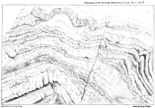
Quartz Rock opposite the Sth Stack. Holyhead Island.
[page break]
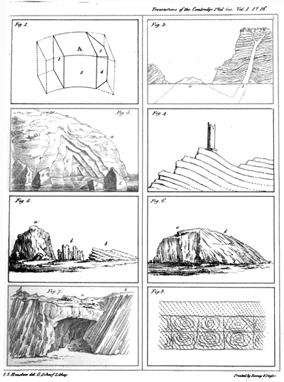
[page break]
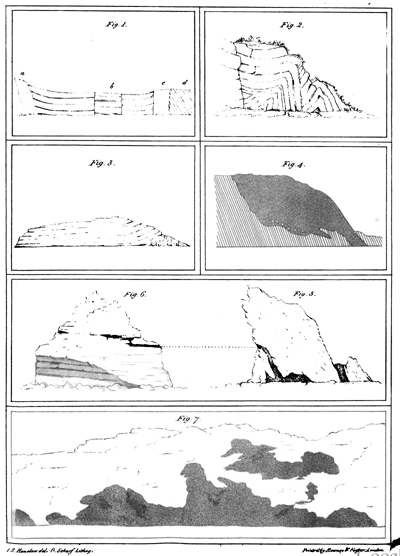
[page break]
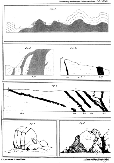
[page break]
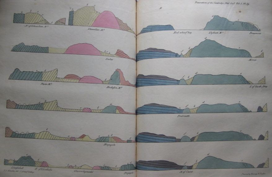
[page break]
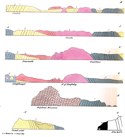
[page break]
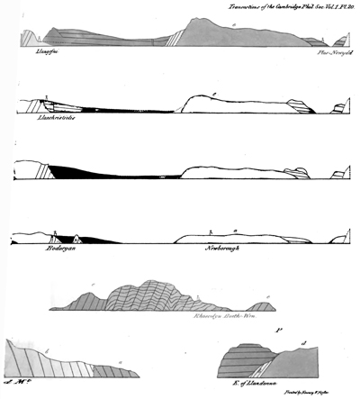
[Geological map of Anglesea]
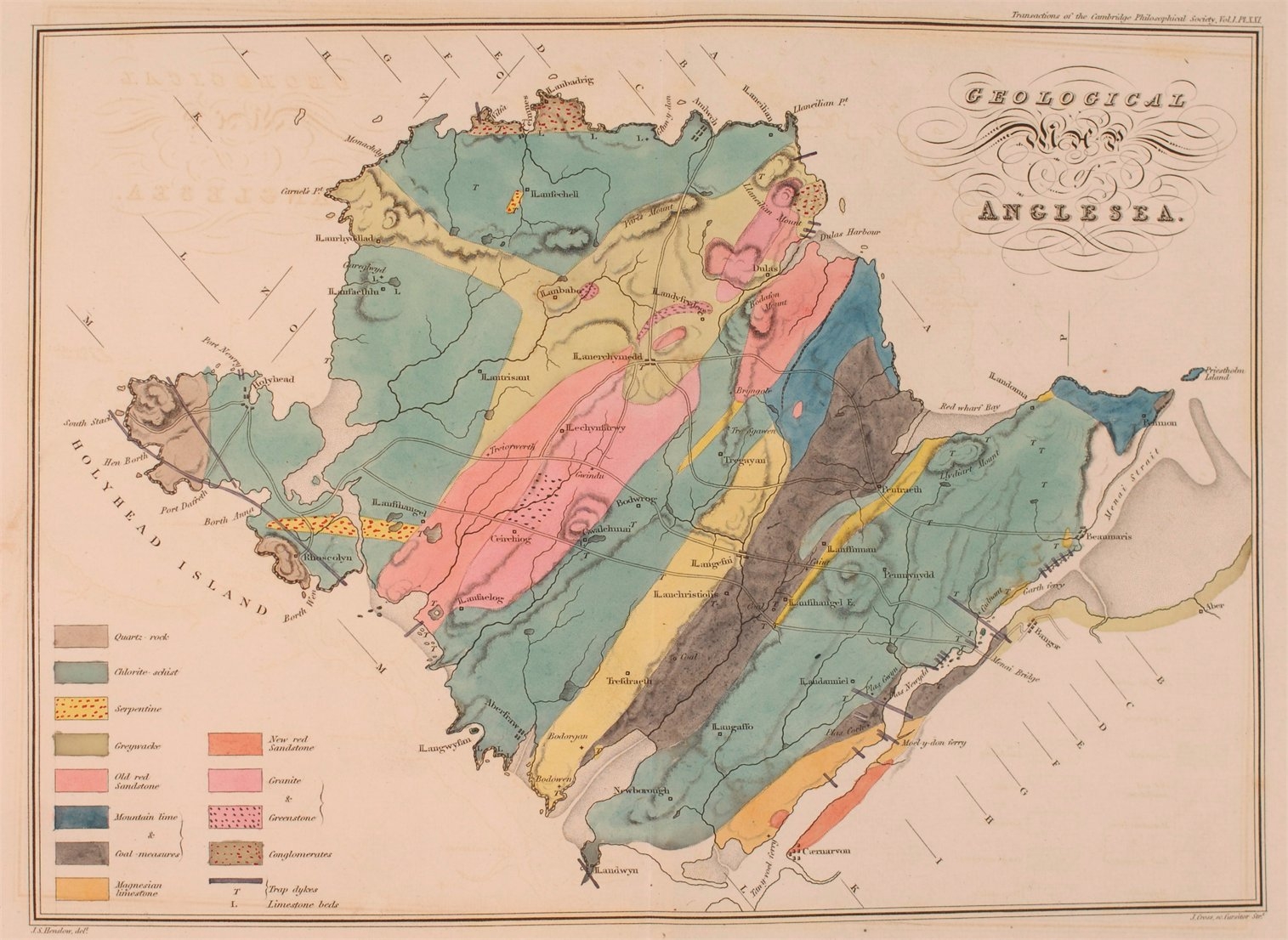
[Geological map of Anglesea]
[title page]