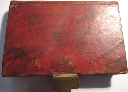
This 15.5 x 10 cm notebook is bound in brown leather, the brass clasp is intact. The front of the notebook has a label of cream-coloured paper (6 x 2 cm) with 'Banda Oriental S. Cruz.' written in ink. The end pages and edges of the paper are marbled. The notebook has 242 pages plus the covers, all written in one sequence from the front cover. Two pages were excised and 124 are left blank (pp. 112-236 and 239). A piece of cream-coloured paper pasted on the inside back cover (measuring 2.5 x 11.5 cm) secures a brown leather pencil holder added by Darwin.
[front cover]
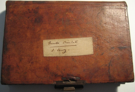
Banda Oriental
S. Cruz.
[inside front cover]
[page 1 blank]
[page 2]
Charles Darwin
H.M.S. Beagle
[page 3 blank]
[page 4 blank]
[page 5]
14th [November 1833] Started in the afternoon & arrived at Canelones
15th [November 1833] Started early — very much delay at the 2 rivers. passed the town of St Lucia. — grand green undulations, country does not appear flat to me = country between St Lucia & St Jose no rock — St Jsé granite with large crystals, afterwards some gneiss — José — Lucia — Canelones nice Towns — every-person armed atrocious murder. — crossed Pabon & slept near R. Cufré — saw in Plata fine green undulating Pampas view —
Owl killing snake.1
General season of day-feeding
1 See specimen 1293 in Zoology notes, p. 161; listed as Athene cunicularia in Birds, pp. 31-2.
[page 6]
woodpecker nest in hole:
16th [November 1833] — Stayed all day in fine old hospitable Portuguese; stomach disordered & river of Rosario much swolen: nice Estancia; granite & gneiss former in large crystals with silvery mica & garnets.
17th [November 1833] unfrequented camp.
crossed Rosario deep & rapid. no boat (yesterday Postman with 2 letters principal towns) breakfasted village of Colla said to be Limea— much granitic rocks. — Country moreunevenarrived at Colonia. at ½ after one delivered my letters; Head of Police received me in his house son agreed to go his Estancia on following day, so I staid Town pretty looking from irregularity few vessels, ruined church
[page 7]
much injured by Brazilian war: general injury to country from same cause. making so many officers — good sign general & extreme interest in representatives. — heard person say that representative of Colonia — were not men of business. but could all sign their names: Town on a point. harbor made with islands (anecdote about French survey tell Captain). — like M. Video Church very curious ruin 8 years ago 11 killed: not much powder, very massive walls — so completely shattered rock of Colonia (V Specimen) very fine grained. dark black gneiss. [siliceous] much resembling that
[page 8]
that class of rock at Maldanado — the cleavage run E & W vertical or to N. crossed by parallel & approximate lines of fracture. — In one of the streets; fragments of the great oyster, dendritic with manganese. — Was told a French-man was making a mine & that Government stopped him; said to be entire & juntas forming a bed. !! Are they a fragment of the real St Jose bed, or washed in a heap by some former rush of water — decidedly only occur in this one spot about 15 feet above high river. — not washed
[page 9]
certainly by present river or they would be more universally abundant. — [Sunor] It is certain the Gneiss must be a few feet below. —
(18th) [November 1833] Whole country surrounding the town red earthy Tosca (as at M V.) with very numerous concretions & honey comb plates. — One side of harbor has barranca. prescisely resembling those St Gregorio — base a coarse sand — or rather: minute fragments of quartz — above a marked line of separation. — white sand, pale Tosca & common reddish with
[page 10]
numerous white Calcareous concretions. — In one place in line of separation some few small muscles shells. such as at M. Video even retaining partly their colors. — Is not this important as connecting the very modern shells beneath gravel with Calcarious Matter, with their showing gravel & great Tosca formation co-temporaneous: Height of line above sea high river about 15 feet & always fresh water: — From Colonia to R. St Juan country is undulating little rock like that of Colonia — In the Sierra de St
[page 11]
Juan some slaty gneiss cleaving N & S. other irregularly NE & SW. Some beds of quartz & some gneiss more granitic. — In the pass of St Juan there is some earthy pale Tosca rock. — But what is remarkable along whole side of Sierra & not much inferior in height are beds of pure white mortar & of semicrystalline often puddingstone Breccia with fragments of Granitic rock (many large) (no specimen) some opaline rock all mingled together evidently facing the side of granitic rock & almost surrounded
[page 12]
by hills of granite, chiefly on low hill (these phenomena in several places) The hill is clearly formed by vallies being formed at base of granite hills — I should think had formed a plain interfolding amongst hills of granite & not posteriorly lifted cannot say. — evidently lies on granite & beds not thick Formation precisely resembling those at foot of Sierra Ventana & Tapaken only rather more extraneous pebbles. — How is it this formation is better seen near the
[page 13]
hills? Has been burnt for lime seems doubtfully to answer. — [vey]
very curious finding this formation here. — 
shaded ones Lime. —
Degrado same colour outside as Patagonia in west precisely same formation. eyes shut think I was in Patagonia: —
On surface fragments of Granite much alluvial action:
Rock about Estancia Gneiss. — Near the Sea River, 6 or 10 feet above level of swamps are sand banks of same form many Medanos
[page 14]
as those at Bahia Blanca, with very numerous Bivalve shells, said to be still more numerous at mouth St [Francis] if they are fresh water small [ex] charge is necessary if salines. requires greater change in configuration of Sand. but does not relate to muscles under Tosca. — In evening had [pleasant] ride about Estancia. Exception Mercedes 2 & ½ leagues square excellent rincon ∴ water, much wood for exportation — Lime [illeg] horses very good Corall & Garden 3000 Cattle — 600 Sheep 800 Mares 180 broken horses Harbor. —
When Limestone is pure [genus] shells. — the Aluminous matter injurious to shells.
[page 15]
has been offered 2000£ wants 2500 (or perhaps less) How very cheap. — Cattle driven twice a week to centre spot & then by the union of Tropillas counted. Tropillas recognised by curiously marked animals. —
(19th) [November 1833] WNW of Sierra de St Juan Mortar — Hills appear to run N & S between the head of two streams. — Calera de los Huerfanos 4 Leagues before arriving at Las Vacas Mortar formation. (V Specimen) Generally more white & pure: a few more hundred yards further on — a highly ferruginous sandstone with specks of quartz
[page 16]
mingled irregularly with a paler & less sandy sort — This occurs irregularly till their are some low hills near Las Vacas — Here the same rock occurs very abundantly. — & in section of "A tres Bocas" is seen lying over pale Tosca abounding with calcareous matter & concretion — The summit of the hill granite — in this manner there were repeated alternations of gneiss granite & this Sandstone. — The latter here contained large fragments of Quartz. — Wood Much wood like Corinda. — Las Vacas
[page 17]
straggling thatched town wit on Riacho with many small vessels: much delay & trouble. — No Biscatcha. Cuervos soar in flock: —
The very red sandstone evidently is of same formation of the mortar — extends very far (is said) to the sources of Las Vivoras: Slept at the Calera de Carmacho
(20th) [November 1833] — Narrow bed of Limestone extending from near Mouth of Las Vivoras to Punta Gorda & crosses to R [Nankry] in Entre Rios — "Sylvester Lellow complete collection of Banda Oriental." ?? !! — Much of the Limestone
[page 18]
is grains of quartz cemented together. — generally pretty pure with casts of many shells & sometimes large oysters. — beds separated by beautiful white sand. Considering the gradual change of Huerfanos. — the great change of red Sandstone, I think this same formation with mortar; it looks as if this bed with respect to red Tosca does not remain constant: the Lime requires same time [as] &c with Bajada — House 108 years old. — old woman of 90 years old positively states that very early in her life no trees ?!
[page 19]
no trees except one orange tree Lime Kiln fairly covered up by diluvial bank so as not even to be guessed at. — trees grown over mud Time of revolution Lime left [in] in some kilns for 18 years quick in middle yet, burst out in flames constant occurrence superstitious fears — vegetation above: — Curious subterranean arch at Colonia. — 3500 small green parrots killed in one field of corn near Colonia. — Jaguar (went out hunting) cut trees on each side with claws sharpening
[page 20]
plagued by Foxes barking never return to dead body: Gato pajaro1 inhabits Banda Oriental. — Coast of R Vivoras, R. Uruguay regular red Tosca with numerous balls & oblong pieces of hard white Tosca rock. At Punta Gorda this occurs beneath a pale clay with the large Oyster shells & above the regular white sand & Limestone. the next Point further up is pure Tosca — Here we cle clearly
1 See specimen not in spirits 1443 in Zoology notes, p. 392.
[page 21]
have same bed beneath Limestone as is above at the Bajada; only in the latter case the Tosca does not contain so many nodules: One man lassoed 22 mares on foot in Corrall, tied their front legs, killed, skinned & staked them. Other man will but stand at mouth of Corrall & throw every animal by lassoing legs as he leaves: Other man will skin 50 mares in one day good work to skin & stake 16 — After our pleasant ride to Punta Gorda in the evening
[page 22]
started for Capella Nueva Mercedes: only rode a few leagues, through Coronda like wood, & arrived at very large Estancia. immense land owner — The nephew of owner & a Captain was resident there. — After asking me if I really knew that a hole under foot would come out side. ball all you catch take thin people in by land, where there is 6 month of night — & expressing great surprise at being able to go by land to N. America: "answer me one question truly" are not the ladies of B Ay more beautiful than any others." "Charmingly so" — One other question do ladies in
[page 23]
any part of world wear bigger combs. — I assured them not: they were transported & exclaimed — "Look there, a man who has seen half the world says it is so. — we only thought it to be the case. —
Water of Uruguay very black: rapid current: In riding disturb male ostrich from nest: sometimes very savage chase men on horseback — caught by men lying down covered with a Poncho. — (Paludas) Nest of green small Parrot. —
(21st) [November 1833] Started very early & rode quietly whole day. with hired horses. — Passed through immense (no Biscatchas)
[page 24]
beds of thistles: cattle lost. roads closed up: generally as high as horses back; often as high as mans head. — as the geology here resembles that of Buenos ∴ we have the variegated thistle. both sorts in almost invariably conjugate variegated the worst from height — Very uncomfortable riding obliged to make great turnings. — Before arriving at the town of St Salvador — much mortar, white rock & Tosca rock — also the ferruginous dark red sandstone — All this forms bits of horizontal beds occasionally [illeg] Limestone up concretion Uruguay
[page 25]
to be seen passed one after [the] other (red rock first seen a league or two before crossing R. 3 Bocas) Near source of St Salvador soon after leaving white mortar rock — arrive at bed of white jaspery rock marked with manganese — containing nodules of milk agate — externally decomposing to great thickness into soft white rock — Something of same nature as one specimen found in Mortar of Sierra de St Juan — In one part of road These small pieces of granite rock. — Then white Mortar. Then red rock We slept at small Rancho near to where I was going
[page 26]
it being late in the evening. — Next morning (22d) [November 1833] arrived very early at the Estancia of Mr Keen on the R Berquelo near Mercedes — Many highish hills all flattish tops & low Barrancas of this red rock — which lower becomes whitish with red streaks & concretions
(V. Specimen) still lower it is white sand cemented loosely together: These flat topped hills run NE & SW interrupted by wide transverse vallies. — Pietras. Maldonado (are there black rabbits on West Falkland )1 Lower in the vallies there is a hard sandstone
1 This may be one of Darwin's earliest references to island endemism.
[page 27]
or rock consisting of minute fragments of quartz of various degrees of purity & very hard. — This in parts contains beds of Flints, with veins & conchoidal fracture.
V Specimens — in sinking wells here & Mercedes, this flint is the lowest rock. —
In one place sandstone contained large pebbles of quartz & granite. — it here contained inferior layers of mortar. — & some whitish Tosca. — I have no doubt such beds separate the sandstone & subordinate flints from the ferruginous red sandstone
(23d) [November 1833] On road to Mercedes
[page 28]
The grit sandstone occurs of various [puentes] with more or less Mortar passing into more or less pure Limestone. — At Limekiln this side of Mercedes, Limestone occurs beneath a siliceous bed with much botryoidal1 quartz (V Specimen). — At Calera Daca. — the rock is fine hard white mortar with siliceous [veins] lying on a gritty sort (or grit sandstone cemented by lime (? is not all Sandstone thus cemented:) No organic remains — It is said that near there the red ferruginous
1 Bunched like grapes, a habit of some minerals such as haematite.
[page 29]
sandstone occurs above the Limestone — which is as I should suppose. for certainly the grit sandstone & Limestone are all of a bed — occurring above or in mortar & Tosca beds & here occurring above. — at [Tres] Vivoras above clay. — But I think from general local high position the red sandstone is a superior formation — R R Negro fine river with fine blue water, & well wooded; pretty valley. — poor straggling town. — (Curious pebble[s] from coast of Uruguay. — Rincon de las Gallin[ac]
[page 30]
(24th) [November 1833] Started for Pedro Flaca, went wrong road travelled through very long grass. (uninhabited) above horses back like oats. — on road saw with mortar, some fine red Tosca — & afterwards the very red sandstone above Mortar: at Perica flaca cliff about 50 feet high. — upper bed prettily coloured flint (V. Specimen) or agate. mixed with the very pure tallow - looking Limestone — actually mingled together in masses so that bothryoidal silex on the Lime. — grit sandstone & finer sandstone largely conglomerate, rounded pebbles coloured pink (by Mangenese). — grains
[page 31]
of sand cemented by Lime. — & ¾ of lower cliff various degrees of purity of mortar with some bed & masses of reddish Tosca hard. — calcareous lowest bed pretty pure mortar. — This is contrary order to what is general — for flint generally appears to be lowest. — In very many parts before arriving at Perrica Much fine red Tosca. I must think this beneath red sandstone The question is whether Bones occur in Tosca contemporaneous with Punta Gorda bed, or with Bajada Monte Video // Punta Gorda very satisfactory seeing Tosca beneath solid rock //
[page 32]
view of Rio Negro from cliff very pretty — river 2 Severn — fa current very rapid. banks well bushed winding rocky cliffs — decidedly most picturesque view for the last four months: Horses tired left Peon behind. — excessive heat Pantanas. — Late at night:
(25th). [November 1833] Rode to dig out bones of giant; found in place evide washed down & covered with sand & clay, when first discovered were in dry bank. — now under
[page 33]
water. — bones scattered broken lying close together about 20 yards distant bed of Tosca. — with small line concretions like bed at the Bajada; Interesting as connection between Casca1 & big bones: Wheat Pubrilho2 In evening saw a Domidor3 Mount two colts tame describe process.4 — excessive fright. — horse died yesterday. —
(26th) [November 1833] Started went round by a house to see large head & bones, washed out of Barranca & found after a flood. — pieces here
1 Spanish for 'shell' or 'helmet', most likely meaning armadillo-likecase.
2 Specimen not in spirits 1593 in Zoology notes, p. 394 and Beagle plants, pp. 174-5. Darwin's notes have not been found and were apparently given to Henslow who published an extract in Henslow 1844; Shorter publications, pp. 176-7.
3 Spanish for a horse-breaker.
4 Described in Beagle diary, pp. 204-5.
[page 34]
also of Casca —
Barranca. Whitish Tosca — Sand — which occurs for a considerable distance, [is] most probably diluvial hence animal of Tosca & diluvial age — 4 or 5 leagues to South of Mercedes plenty of Quartz — then little grit sandstone — plenty of primitive rock — then large bed of flint — finally all great blocks of primitive rock. — Granite in immense blocks near sleeping place — Sleeping place 3 leagues beyond R Perdido — very bad
[page 35]
night — wet through; extraordinary thunder —
// Bones from the Sarandis1 will not have paper in the box: //
(27th) The white Tosca bed certainly different from the usual grand covering. probably of a different date.
(27th) [November 1833] country whole distance Primitive gneiss running W by N & E by S & NW by in other locality NW by W & SE
by E: Bad Indian Gallego:2 —
Slept at one stage beyond St. José. —
(28th) [November 1833] Arrived in middle of day by same road to Monte Video —
1 A small river entering the Rio Negro.
2 'One of the Post-houses was kept by a man, apparently of pure Indian blood; he was half intoxicated. — My peon declares that he in my presence said I was a Gallego; an expression synonimous with saying he is worth murdering. — His companions laughed oddly: — & I believe what my Peon said was true; when I remonstrated with him on the absurdity, he only said, "you do not [know] the people of this country".— The motive must have been to sound my Peon, who perhaps luckily for me was a trust worthy man.— Your entire safety in this country depends upon your companion.' Beagle diary, p. 204.
[page 36]
At Las Pietras red sandstone in horizontal beds near to which [in] fine granite specimen is finer than the generality —
Padre with a tail very heavy & solid, fragment 17 inches long, circumference (longest) 11'1/2 at end before blunt 8'1/2  Vertebra within attached to the case — extraordinary weapon.
 Solis [Arroyo] Seco — Tooth. Solis grande. — & Tala about 10 leagues N Branch of St Lucia,
Arroyo Tala
I believe name Don Damasio de Laranhaia. Griffith1
Vol 133 [Pernetty] p 133
1 Cuvier 1827-35, vol. 11 (edited by Edward Griffith), p. 133, discussed Don Domasio's announcement of additional bones of the head assigned to the Megatherium.
[page 37]
I think, the limestone & clays with oysters, the sandstone, flints all are variations of Tosca bed with concretions (∴ red sandstone above such varieties & above Tosca & Limestone above Tosca) That the red sandstone is above these: That possibly the bones are found in an earthy Tosca above this sandstone (∴ more mineralogically like beds at M: Video) But that fossils to the W of Parana & B. Blanca belong to bed below limestone or if not such perfect coincidence in formation shows circumstances very similar. — I have little doubt respecting sim: of sandstone here & at Maldonado & Gypsum to the N: V Mawe.1 —
1 Mawe 1825. See Correspondence vol.1: 562. This page is one of the earliest ink essays in the field notebooks.
[page 38]
18th [April 1834]1 Started pleasant sail to [nearly] above tidal influence
Armadillo — noticed several successive plains; some quite low 20 feet high: yet with regular gravel & apparently earth — ∠r Blocks
character characteristic of original gravel?) — plains to the N. fresh higher series: caught mouse:2 pleasant party cheerful running water: ⅓ of mile
(19th) [April 1834] 3 parties tracking many islands like Pacana: bad walking rapid very clear river over pebbles shallow hence troublesome. few Guanaco or ducks. no fish or animals or fertile ground Horses head: Callandra
last ؟sleeping place oysters arca & 2 Univalves gravel white-washed (
1 The second sequence of entries begins here, in pencil.
2 Possibly one of the specimens not in spirits 2066-2067 listed on p. 402 of Zoology notes.
[page 39]
singing: flocks of Sturnus Ruber: cliffs with Turitella: Slate pebble little E of 2d sleeping place: larger pebbles, more truly porphyritic: 2 elevations (first one most weathered & an apparent third one.
old valley of river chiefly gravel & like a bank.
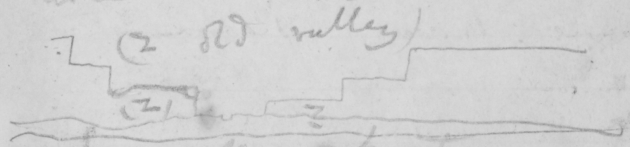
[sketch]1
(2) (z) (2 old valley) severe frost
20th [April 1834] same fact of series of Plains: at sleeping place nearly ½ the pebbles dark compact [littly] fissile slate amygdaloid & a fragment of gneiss: curious small travels if pebbles into sea from so pebbly a river:
1 A very similar diagram was published in South America, p. 10.
[page 40]
small salitrales: country rather more open: river rapid banks pebbles tracking on N. shore: good general arrangements: drift tree: large herds of Guanaco: Ostrich swim. (river generally 17 feet deepest & ⅓ of mile wide — here narrow: about 5 miles an hour — Alarm of indians: horses bones great smoke, parties kept close: but quietly found good sleeping place: day has been splendidly fine: but country terribly uninteresting: no living beings. insects fish &c &c Same plants, same bushes growing on same formed land
[page 41]
(Effect of Earthquake in Chili on river courses) Beyond this Terra incognita boat-hook:
21st [April 1834] First boulder 7 feet circumference depth 18 inches perhaps as much below: Quartzoic or Feldspathic? (V Specimen) Fish light greenish brown above with small blank transverse irregular bars — belly snow white: numerous same size in inlet. Fringilla common & sparrow good success No condors but Carrancha Indians tracks with Chusa thought they had reconnoitred us: then mark of mens feet & dogs as if crossing the river (here 200 yd. & 30 & feet deep current 6 knots)
[page 42]
marks on other side: Children: granitic pebbles: drowned balled Guanaco — eaten:
22d [April 1834] (Tuesday) many slate & some granitic pebbles I think former, perhaps solely connected with the lowermost sets of plains: I could trace 5 sets of plains — lowermost perhaps only 20 feet above river: as the highest is 500? feet: the lower uneven stone is a white sandy marly with angular cleavage like 2d bed
[page 43]
at P. Desire & St Julian (specimen 2). contains some Turritella and Ostrea &c: at one place cliff 120 upper half this the gravel — & within ¼ of mile cliff of marl only 20 covered by about 60 of gravel belonging to 2 sets of plains: gravel often covered by earth bed: country more broken
[page 44]
river more rapid, banks bad. two spells. smoke to the South: weather beautiful country of Patagonia extraordinary similar: burial places of Guanaco. 10 skulls together pebbles in lower plains white-washed: curious (sleeping place) infertility by a little stream. little life analyse marl — salitrales. which are present perhaps cause:
[page 45]
// red-nosed mouse // long tailed grey creeper: // of the 5 plains perhaps 2 highest best marked: Callandra:
23d [April 1834] (Wednesday) Rested till noon to mend clothese, clean arms &c. — caught Notonecta.1 Colymbetes Staphylinus & Bembidium:
The bushes of R Negro owing to gravel: the present river is only a gut2 without valley. the three lowest plains, are not very level & perhaps are owing to former less rapid river: some of the plains differ in
1 A genus of aquatic insects in the order Hemiptera, commonly called backswimmers.
2 'a narrow passage, a channel or run of water, a branch of a stream; a sound, a strait'. OED
[page 46]
height solely from thickness in gravel. a cliff of 80 feet only had 10 or 15 feet of marle & this not horizontal, but worn: gravel cut by earth ∴
immense quantity of gravel! slate pebbles. certainly more numerous: many Callandra: many rodentia:
proceeded little further slowly owing to cliffs
[page 47]
obliging us to cross river &c
24th [April 1834] — Finely cellular irony scoriae pebble: stream from quantity of slate like Tierra del F: Cliffs with white (calcareous?) lines: other cliffs with many Ostreae & great, red concretions, like at ship: more Slate pebbles in stream than in lowest plains, some of these latter plains are perhaps owing to present river, but I think only few, from little floods I do not understand how & plain 200 feet high could
[page 48]
be formed: also in some places it clearly is a gut between marl: — perhaps the highest plains are separated from the 2d highest by old valley 10 or 20 miles wide for here action of sea is less probable than at coast: killed Guanaco, goods days tracking; country more level: I do not see that the plains are at all higher
[page 49]
than at coast: illusions about lakes & mountains: Guanaco when wounded always comes to water ∴ when ill: — pebbles being whitewashed in low plains look not like rivers? —
(25th) [April 1834] [illeg]
29.995. A ther 56
29.550. A — 60
Noon (Latitude) 2d highest plain — one higher perhaps 150 or 200 higher: gravel slate pebbles: cliffs composed of yellow or greenish earthy clay easily disintegrated with white bands: large red same concretions:
[page 50]
no shells (I saw): Before this I ascended table land with gravel pebbles & as here noticed 2 great plains the upper perhaps & lower certainly follows the valley the three lower plains are very obscure: there [was] one (at noon) of some elevation, perhaps not explicable on principle of river forming low plains & then cutting a deep valley gut & commencing other plain Noon valley between the 400? cliff & other side (which perhaps are the highest series?) 5 miles wide. The period between 1 & 2 old plains much shorter
[page 51]
than between 2d & present (other elevation intervening) Gravel in same places almost cemented by (marl?): white matter. —
My great puzzle how a river could form so perfect a plain as 2d & cemented even in its highest parts — draining of sea ??? —
How was valley at Port Desire formed before elevation sea ?? : At this (noon) cliff many of the stone was coarse sand slightly agglutinated by ferruginous aluminous matter: one pebble of dark reddish brown amydgaloid (with agate on brown cavities)
[page 52]
has for the last three or four days been very abundant it is quite impossible to overlook it at coast: Saw an ostrich about ⅔ size of common & much darker coloured exceedingly active & wild very goods days tracking [The figures in this table refer to the explanation on p. 53.]
| 26th |
A |
29.883 |
A |
59 |
| |
B |
596 |
A |
63 |
| |
C |
454 |
A |
67 |
| waterside |
D |
29.904 |
A |
71 |
| |
E |
— 516 |
A |
71 |
| |
F |
— 629 |
A |
69 |
Spring at foot of Lava 49.5º — water edge 29.902 A 64 D 57
[page 53]
a third lower plain alluded to yesterday is about ⅔ height of Lava plain (B) it abounds with great masses of Lava therefore valley of river cut through these by ordinary means: between noon of yesterday & todays Longitude first noticed great blocks of this Lava. (or amygdaloid which from its less specific gravity float further) [The following list corresponds with the table on p. 52.]
(A) at Waters edge
(B) — Low Lava cliff (there was one higher)
(C) High plain at back of (B) & probably of same height with that of noon of 25th
(D) waters side the two first observations were taken nearer to (A)
(E) Main lava plain
(F) Spring at foot of Lava
— (G) Waters edge (near F observation)
[page 54]
The lava cliff commences half way between noon of yesterday & to days Longitude only on north side, on South side cliffs of pure marl to waters edge like those at noon: The Lava is black augitic sometimes with olivine, the upper part very vesicular (Like Port Praya. valleys precisely same sterile scenery): it is in upper parts regularly hexagonal: there are more than one plains which Barom will show: there are lines 2 or 3
[page 55]
lines of separation, where the Lava is more vesicular & looks like separate flows: hence distinct plains: Columns of Lava filled & separated by mortar (V specimen): The plains to the north of yesterdays noon & of (C) are so much intersected & broken into escarpements that I almost think it must be effect of sea, which will explain gravel cemented by Calcareous matter if the the great range of cliffs South of river was as it looks same elevation of noons yesterday & (C)
[page 56]
Then these highest cliffs could not form side of valley; & the third plain (& formerly 4th) might be explained by altered height of river: The Lava plains are all lower than (C). The thickness of Lava is at least that between E & F: if & probably the total for the spring probably breaks out where lava overlies marl: But this is not quite certain: in two
[page 57]
places in one narrow valley, there was in an inclined surface yellowish sand slightly agglutinated & without any pebbles, as at noon: in another pale bed I was surprised to see few small stalacti on concretions with manganese: now I can hardly think this valley was formed & these beds deposited in it at bottom of sea: (some porphyry pebbles on Lava plain) From horizontal stratification
[page 58]
& considerable elevation of site of these beds (good way below Lava plain (B)) perhaps at equal height with spring there (earthy yellowish Tosca as it would be called in the North) must be coincident with basal beds of yesterday's Noon: But why a Hence I imagine this lava is intermediate, but high, bed in marl formation: It cannot be superior because surely then
[page 59]
the Lava plains, would be the highest: That these lower lava plains should be present is likely because superior beds might be denuded they remaining: perhaps it actually is in middle in plains like (C), indeed it almost must run under them, for they were not more than 1 & ½ at its back:
[page 60]
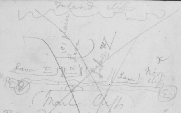
[sketch map with marl cliffs]1
Inland Cliffs Lava E (C) plain 2 Lava
Like x x Z Lava Noon cliffs x W R P E Marl Cliffs (P) 3rd lowest plain
My puzzle why Lava escarpement is not seen at (Z): — Perhaps the Lava terminates in points: The course of river has been determined by South limit of Lava:
Condor is present solely where mural escarpements legs pale. Lump on
1 See a fair copy of this sketch in the geological diary DAR 34.134v.
[page 61]
head: Dark kelp bird:
If the marl in valley is subsequent, it must be anterior to gravel, but surely it would contain volcanic particles:
Boat injured bad days work: Most interesting geology, distant hills:
The highest table land must be over the Lava: certainly appearance looks as if Lava capped some soft talus-forming mass. (Character of sand is such that with wet cakes & cracks): impossible not to be struck with resemblance of mortar in Lava &
[page 62]
gravel at R Negro:
The Tosca rock concretions are curious as showing recurrence of same mineralogical substances at long distances, under somewhat similar circumstances, not as any proof of similar formations:
(A) Cellular superior Lava
(B) Columnar Lava (common sort beneath cellular
(C) Calcareous matter between columns of (B)
(X) Fine grained compact marl lower bed some days since
[page 63]
Sunday 27th [April 1834] Globular Lava passes into columns
Waters edge: |
29.834 |
A 41 |
D 41 |
Lava Cliff |
29.332 |
A 46 |
D 47 |
Little Hill |
—.264 |
do |
do |
Waterside |
29.672 |
A 58 |
D 55 |
This fall ought not to [be] allowed or only about ½ of it: measurement of Lava plain (E) is best, but difference of Little Hill must be correct: If as I suppose this little hill is part of plain (C) & there were other appearances further on of same fact) Then difference & height of the either of two observations of Lava plain ought to equal (C): This little hill in vege[t]ation & gravel
[page 64]
exactly resembles the plain, there were no Lava pebbles: Having seen this gravel cemented by Calcareous matter explains the veins between columns of Lava: I believe Lava flowed thro between the formations, was partially or entirely denuded & cover when inland & highest cliffs was formed: the gravel of little hillocks being deposited (or even perhaps some marl?) its present position accounted for by resisting
[page 65]
denudation: I think it must be thus, & that Lava extends beneath highest cliffs: Lava highly sonorous, where cellular very tough: one clear separation of line of greater cells & large cavities & resting on a surface of balls — (this appearance is seen on the plains occassionally) above this line, which is less than ⅓ of whole Lava bed Lava columnar. other lines but less distinct: this main line shows two streams
[page 66]
cracks where water entered might be traced by cellularity: That the Lava rests on marl is proved by great slips & lines of springs:
Valley now simple, straight 5 or 6 miles wide, South cliffs same height with what? —
Shot Condor! length 3f 8in tip to tip 8 ft iris scarlet red. pairs with young ones, female: magnificent bird: good days tracking.
[page 67]
(D) Highly sonorous. common lava
Projection of coast from C. Blanco to Port Desire owing to Porphyry
St Elena do? —
High land between [Herr] Bay & St Joseph. —
28th [April 1834] Surface of Lava generally rather undulatory: great hexagon column 12 feet each side: earthquakes great slips inclined towards cliff nearly ∠ 45º: —
E. The common white or yellow slightly agglutinated sand; beneath Lava
F. Fragments of a Boulder mentioned before
G. On plain Pitchstone or Obsidian
[page 68]
Waters edge: |
29.466 |
A 64 |
D 59 |
Plain |
Z 28.944 |
A 59 |
D 55 |
Crater: |
28.734 |
A 54 |
D 52 (?) |
|
29.520 |
A 52 |
D 48 |
Perhaps one third of this rise, ought to be allowed for the Plain (Z): seated close to the river & scarcely anything between the Plain & Crater. —
This plain is situated like (Z) in the former plan on each side there are Lava cliffs & behind it likewise: I imagine it to be same height as it is in constitution as the Noon cliffs: perhaps it may
[page 69]
be considered to belong to the Southern cliffs: it is remarkably level & gravel much white-washed so I that I think it must have been formed beneath sea: I am doubtful whether the South cliffs are higher or not than this: The Lava cliffs are here exactly same height proving a thickening in the bed to the Westward: If these plains have been formed by denudation of higher ones, of course the Lava would put a stop to this action. hence levelness of these soft plains & those of Lava: This plain rises gradually
[page 70]
To the hill which I have called Crater forming a sort of plain without hillocks of Lava smoothed with gravel: the lava plain gradually rises to this. Is this Crater or lava flowing over other field: if it is not continuous to the West, this is form more probably (from inclination of bottom would cause a greater East, than W flow)
This hill is about half as high as some neighbouring pieces of table land, (called the highest inland cliffs in other places). I continue very uncertain concerning their origin: observations
[page 71]
to the East before Lava will now be the more necessary: & especially height of South Cliffs: — Before this I satisfactor[il]y saw the yellowish agglutinated sand (E) & white bands no org. remains underlying lava, but not in contact: the stream of Lava must have had a fringed edge. such plains as both (2d) occurring in indentations, valley of rivers line of fringe: At the sleeping place (of yesterday??), & further West valley opens: & 2 or three lower plains may again be seen. — The Southern line of cliffs most regular
[page 72]
I may notice in lower part of marl cliffs some harder much laminated sandstone: Saw a Skunk: found Indian tripod, first signs of man since the ferry: small grave: drift timber: immense herd 1000 ! of Guanaco horses cannot hunt for gravel. — Guanaco sleep tail in centre, in same places in different nights then dung: dust in saucer shaped cavities
[page 73]
(V other page)
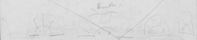
[lava 'waves']1 (double)
A curious appearance of the Lava — where perhaps currents met or were stopped. throwing up several waves. about 2. feet high; & broard as represented columnar from a centre. therefore easily seen seen in a valley.
1 See a fair copy of this sketch in the geological diary DAR 34.139v.
[page 74]
At the sleeping place there was a most deceptive appearance, for ¾ of mile hillocks of marl dipping at 45º to cliffs & vertical & even from them, covered with blocks of Lava — yet only a great slip cliffs ½ a mile inland — layers of calcareous sandstone together with odd square masses of indurated laminated do. — & some very calcareous strata. V specimen
[page 75]
(29th) [April 1834] The plain (Z) of yesterdays seems to have divided the stream of Lava — in its back parts perhaps containing some: at the foot of it there is one of the lower plains ⅔ height, level, whitewashed gravel, lower parts marl: Having passed plain (Z) The lava is seen in several plains, one above the other, the backs one most clearly beneath the inland cliffs, they are not level but rise to the West They cross the river forming
[page 76]
plains on that side, which seem of no great extent, but perhaps some distance beneath great S. Cliff:
After dinner ascended some still higher lava cliffs, probably much higher than Crater hill, the lava is different, contains much crystals, is greyer more compact, less cellular probably formed under less pressure, yet under sea from porphyry pebbles & many blocks
[page 77]
of slate! Lava laminated. (Before this I found Lava with same crystals)
The was lava was much thicker; as seen by springs but rested on same as before: Surface very irregular many hills & central depression with lake — much diluvial action — lava in one place like wave V drawing — In the NW irregular hills probably Lava — This (plain?!) perhaps as high as inland cliffs, of which traces were yet present: How far connected together ?
[page 78]
Saw a regular eyrie of 20 or 30 Condors — 2 young one with the old: saw distant snowy mountains
(H.) Calcareous rock in marl sleeping place (28th)
(J K) Grey Lava with many crystals from highest land on the 29th —
(L). common still greyer more laminated variety
(M). common black vesicular Lava with do crystals
(N B shells in coast cliffs must have been pelagic. —
Curious no mixture of Porphyry pebbles with marl. yet requiring such ages to manufacture them:
[page 79]
30th. [April 1834] — I think the lava overlies the greater part of the gr. Oyster bed: but from appearance of yesterday & before is covered by the upper parts. perhaps marks the changes so often noticed on the coast. it is certainly covered by the Porphyry pebbles. which must be altogether independent of it: — The lava yet rises, irregularly towards the West & again occurs to the S always overlying the white horizontal striped beds But I do not think these + gravel rise much above
[page 80]
in height than last (Z) plain: (Noon). Valley to the West opens much & lowers & has been (like St of Magellan?) subject to excessive alluvial action. hence on the yet. remaining cones are great blocks of lava & of Feldspathic rocks (similar to 1st boulder) one was 5 yards square & about 5 feet deep! another 2 yards square, pebbles of serpentine
[page 81]
These rocks & slate & pale porphyries outnumber the yellow & red sorts. —
Perhaps the excessive alluvial action, consequent on retiring waters from hills formed the inland cliffs?
X Line of springs & apparent highest limit of soft beds: site at sleeping place: above this black, compact Lava specimen (n)
(Q other variety much laminated)
Waters edge |
29.156 |
A 52 |
D 48 |
X |
28.546 |
A 48 |
D 44 |
Waters edge |
29.046 |
A 42 |
D 40.5 |
Alluvial Hill |
27.873 |
A 42 |
D 40. |
Lava limit |
28.070 |
. do |
do |
Waters edge |
29.042 |
A 47 |
D. 46 |
[page 82]
| 1 |
Calcare[ous] |
|
| 2 |
x |
|
| 3 |
Calc. white specimen (O) |
|
| 4 |
x yellowish iron clay |
|
| 5 |
green (P) |
horizontal strata no org. remains |
| 6 |
x |
| 7 |
3 Calc & brown |
| 8 |
green |
| 9 |
Brown calc |
| 10 |
x |
| 11 |
Cale Soft sandstone |
| 12 |
2 Calc & green |
|
| 13 |
large calc |
|
| 14 |
green |
|
& green conglomerates
conglomerate, with slate & white fine Soft sandstone or rather very ؟
[page 83]
This is section of above measurement, (3) is a broard, white strongly marked bed of light Calc or Agillaceous matter & resembles those of Port St Julian: perhaps occurrence here may be attributed to the source of such beds being to the North; whilst beds at the coast more exposed to currents from the Southern & less volcanic mountains: (5) is a pale green earthy clay; specimen (P): of same nature but more sandy ///// is the yellowish brown: the lowest bed is of the most new character
[page 84]
as containing slate & Feldspathic (most minute) pebbles, it 1 & 2 lines long). it is as might be expected from being nearer mountains: These beds do not from ½ a mile remain constant only in general points, in some places great concretionary masses of Sandstone as at Ship. — These cliffs certainly are very different from the coast — but then the difference has been gradual, first white lines appeared in clayey sand, & which contained Ostrae. [Thes] now like true calc matter
[page 85]
which will not support life: but ye[t] the beds called marl unite those at ship with these here ∴ formation similar: it might be expected that more variation would be met with in beds (& gravels) in this section than on the coast, perhaps this observation generally holds good. — (We know there is little Volcanic action to the South) I am convinced (though often torn) that both N & S of river the Lava underlies upper part of Oyster bed: I confess I do not understand the system of plains in this valley.
[page 86]
(Though little) I suppose the Oyster bed does thicken elevate itself, if as I it is, as I imagine: flow from the Andes the above Lava will be higher than Crater hill. —
Lions scratch ground:
killed 2 Guanacoes, Condors eat one — Cordilleras in full view. Clouds & Climate — River, blue narrower. — Lava streamlets:
The general absence of pebbles in all beds. except this one lowest, shows how entirely the Porphyry pebbles depend on
[page 87]
some violence, & different nature different point of origin. — How immense the period during which this bed of pebbles were formed. (anterior to Oyster form:?)
I see no more of the highest inland cliffs, all is now irregular Lava Hills. —
(May 1st) [1834]
V. supra for water side Old Alluvial plain 28.730 A 51º D do 50º?
The measurement of the Lava is I daresay good: it is varieties (N & Q). it is covered by great mass of Alluvium, where the blocks are immense of Lava.
[page 88]
& the Feldspathic rock & the one with quartz veins & slate from 1 to 2 to 3 yards square & porphyry pebbles: These doubtless are the main rocks of the Andes: one Feldspathic boulder (same sort as before) was 20 yards in circumference, & 6 feet above ground how much beneath? must have been formed beneath sea; from Porphyry pebbles, & cellular Lava. — Surface very irregular & weathered I think it very likely that the inland
[page 89]
cliffs or table land, mentioned since meeting with the Lava is of this nature. if so Lava superior to all great The first inland cliffs can have no relation with these, else 2d plain would have some blocks from the immense pile of boulders. — At the foot of these cliffs 2 Voluta's yet partially retaining their color, & a Patella; now these must at least have come from highe upper parts, proving modernness — for on plains I have seen none certainly near coast one would expect in parts last elevated:
[page 90]
May 1st [1834]
How will Hypothesis that Lava flowed in old strata arrive I ought to have mentioned that the lowest bed in yesterdays section, was some hundred feet above sea. — Capt Fitz found many great Oysters at foot of cliff. — Also in many places pieces of of petrified wood are lying on lowest plains. which I think must have come from same bed with Oysters — if Palms from Lat 50º very interesting. — I imagined the vast mass of
[page 91]
Alluvium is contemporaneous with Tierra del alluvium.— The valley opens; Lava seems to cease on S. side, & the whole [a] plain; one plain which was in line of junction of the two Lava plains seems to represent what generally is the case.
+ 15 feet
Waters edge 29.042 A 47. D. 46
This plain 28.730 A 51. D. 50
it is composed of pale yellow sandy earth containing pebbles from walnut & apples & some (as big as 2 fists), slate & green Feldspathic such as in lowest bed in yesterdays section
[page 92]
& the great Boulders & white porphyries there were some great oysters. some rolled: & beds of gravel: & some with none: This is about 6 miles to W of great section. but it certainly is lowest bed of great cliff range. which indeed lies to north of it with cap of Lava.— plain not very level, slightly inclined to river. — I at There is not one Lava pebble, therefore no Red Porphyry. I at first thought this was an old valley, but if so sides, with Lava must before Lava must have been uplifted ∴ Lava not under water
[page 93]
which we know to be the case & lastly Lava certainly would have filled up old valley: this curious old alluvial bed was formed before the great oyster bed. — Perhaps plains & opening at head of river, might be explained by a strait, at very first elevation water in mountain cut it through in the channels, & so on till elevation stopped the passage & river commenced. — character of gravel is now quite altered, hardly any of St Julian yellow porphyry from great proportion of other rocks: —
[page 94]
May 2d [1834] Bad days tracking river tortuous. great blocks in stream of Feldspath & do slate. 1 & 2 yards square (also on lower plains) Heap of Guanaco dung 8 feet in diameter. Cordilleras in view all day: The North shore trends away, with Lava much weathered into square masses & the patches below white. — The South shore shows no Lava white patches till far distant where the rock (Lava?) forms
[page 95]
lofty abrupt escarpements — The valley has on each side a [illeg] weathered plain (as last measurement) with some [sea] pebbles of Slate & Porphyry:
(N B Saw some blocks of conglomerate ancient) —
There are still some low plains with white-washed gravel resting on a very pale, soft, finely laminated sandstone — This is the common stone
[page 96]
soft Sandstone R
is this lower beds darker more argillaceous layers & concretions of hard-sandstone, & few pebbles of old rocks as in "old alluv". which it clearly belongs to. [illeg] resembling E. coast of T del F. where such pass into each other current cleavage high dip — curious pebbles centre. layer hardish, decreasing on each side
[page 97]
Tierra del F East coast is same as this only here volcanic action has poured out the white beds & Lava (which have not extended to the coast)
I see a gap in the mountains. The river is yet eating a deeper gut in the valley bounded on each side by sandstone.
I do not believe the river could form a plain 20 feet high & many of low plains have this elevation. —
Petrified wood only occurring in certain sites argument for its locality in bed:
[page 98]
Valley 10 or 12 miles wide Lava from WNW Cone of Snow No Lava pebbles in bed of river. —
May (3d) [1834] signs of Indians yesterday skin feathers &c &c guanaco wild ostrich feathers stick & skin
Little Hawk hovers all same Kestrel
at ship gravel cuts. marl
No Lava Blocks in this valley
Granite pebbles: other Block true: white: 5.3.2 dimensions Very few conglomerates
Pebble of strong clay with Turritellae
[page 99]
Noon. Waters
edge 29.269 A 42.5 D 43.5
Sunset 29.280 A. 41.5 D 41
for measurement of River. I could see horizontal lines in white beds beneath Lava on N. shore
Another modern Patella.
Valley though here 10 or 12 mile[s] wide, much lower & serpentine yet generally in gut 20, 30, 40 or 50 feet of gravel, sometimes resting on sandstone:
river so clear; & from so frequently being within sides, too high to be now formed, I believe it
[page 100]
forms very few beds: very hard days tracking river so tortuous. — & some blocks: new alpine plants. —
Brachinus
May 4th [1834]
Sunrise 29.507 A 40.3 D 40
set 29.713 A 45º Walked 7 or 8 miles up the valley, armed 15 men. Saw nothing: Lava to the North broken by great valley — To the South the white horizontal lines may be seen for 5 or 6
[page 101]
miles further to the West. When inclined the strata of rock to the N W
might be seen. — Lava or what? —
Plain 150 60 above river filling up valley & reaching to foot of Andes. — old Basin of sea —
May (5th). [1834] —
-10 feet sun 29.813 A 44 D
rise do? Soft Sandstone more common than alluvium, lined like wood. — Lava field. — river. generally remarkably in gut; especially in higher parts; scarcely any low land; very cold 5 & ½ days tracking 9. Condors. —
[page 102]
May 6th. [1834] — Where I first ascended Lava: many slate pebbles but certainly not like the higher parts much pale Porphyry. probably Andes rock: Valley here widens 10 or 12 miles, independent of in land Cliffs which I could not see: Before beds sometimes striped white, sometimes real Calc stone: Beside the little knoll (which I measured) & there are others on Lava, larger not same elevation:
Proportion of gravel "noon cliffs" 1/7? —
A Little after 6th night from ship cliffs with calcareous, & green bands & concretions of sandstone One Lava block as big
[page 103]
as mans chest: bands not similar to "section." basin of calcareous matter Stopped at night at "Resting place" (11th days in two). —pleasant day many guanaco
Slate pebbles — animals condensed — good many ostriches not having seen them before proof of extreme wildness. —
May 7th [1834] (counting from ship. between 2d & 3d sleeping place.).
200
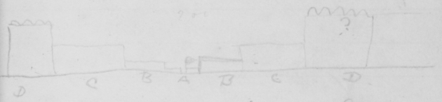
[valley plains] D C B A B C D
A River & its plain. L B lower & more irregular than R B. — (B degraded by River ? has slate pebbles.)
[page 104]
(C) common boundary of valley (D) inland much worn cliffs —
Perhaps D here = (Z) above. —
Slate pebbles perhaps only connected with straits: or = yellow St Julian Porphyry: —
Bed of river slate as yesterday. no Lava. — Faint white lines in cliffs. —
Carrancha soar. — Small chimango
May 7th 8 [1834] — Cliffs on N. Shore [end] as might be expected.
Marl & beds at ship pass into each other: Big
[page 105]
Arcae: & 5 ribbed Pectens. faint white line
Capt. — 30.157. —
My own — . 500: —
| |
|
|
448. |
48 |
46 |
| May |
3d. |
SS: |
29.45 |
48.1/2 |
D do |
| |
4 { |
SR |
— 65. |
47. |
39: |
| |
SS. |
824. |
50. |
48 |
| |
5th- |
SR |
.912. |
48: |
44.1/2 |
Many oyster above & below. — Sandstone —
Arrived on board
Thursday 8. F[riday]. 9. S[aturday]. 10. S[u]n[day]. 11. M[onday]. 12
V Adelante
1 SS = Sunset; SR = Sunrise.
[page 106]
May 12th [1834] PM 11. 12. [gr] sand or rather minute shingle. — 2 & 3 small corallines (such as caught by Clams) & [shingle] 3 or 4 lines in length. Porphyry pebbles. —
4 PM (7) 80 <6 68/.1
8 PM (8) 83
(3 AM) (9) (51)
| PM |
|
|
| 1.15 |
52 |
3 |
| 4 |
50 |
4 |
| 6 |
31 |
5 |
| 7 |
48 |
6 |
| 8 |
51 |
7 |
| 9 1/2 |
49 |
8 |
| 11 |
52 |
9 |
| 5* |
48 |
1 |
| 7 |
42 |
2 |
1 ' 68/.' = sixty-eight fathoms with no bottom found.
[page 107]
Friday 9th
12th [May 1834] Went to sea. good stock of provisions. ship repaired.
false keel masts up: good stock of provisions 10 guanaco bagged:
took some long walks. killed a lion & curious wild cat1 & 2 foxes & condors:
Bad blowing weather sea sick as usual & miserable: very extraordinary change in weather, frost one inch thick. sleet. clouds. gales. hunting for l'Aigle rock 120 miles to leeward, long beat up anchored in evening on the 16th close outside C. Virgins: —
Inland Cliffs 6 miles back Noon cliffs
25th [May 1834] Stokes
1 Probably specimen not in spirits 2036 in Zoology notes, p. 401; listed as Felis pajeros in Mammalia, pp. 18-19, plate 9. See the same specimen in Animal notes, p. 17.
[page 108]
P. Desire High Plains
30. 512
29. 690. } 75 A. —
+ N. [Capac] ? rework [them]
What is cause of granite being to the West of Slate:
Slate wearing away, exposing greenstones.
Wollaston Island in line of Slate less altered: than others.
The WNW line of N part of [Clarence] Island. Mineralogical change
Reread Pampas notes & copy out Gen observation
Color T. del F map1 & read about direction of mineralogical change & M. Video notes about do:
1 Presumably Darwin refers to the hand-coloured map now in DAR 44.13.
[page 109]
Coexistence in feeling in Polyclinum Clytia1 flashes of light??
Cellaria [Crisia]2 Flustra &c. —
[Thur]
With exception of Porph. pebbles & upper alluvium all quiet no anticlinal lines:
High plains with gravel: low with earth: at time of upheaval. or Porph — pebbles: Shells converted into silex & yellow Carb of Lime. Ossiferous3 gypsum generally entirely destitute of shells: Paris Experimentation on shells in Sicily. Blue clay with Gypsum without shells — Lyell Vol III P 644
1 'Clytia formerly included with bryozoans among the Sertularians, is a hydrozoan of order Leptothecata.' Zoology notes, p. xxvii note 48, see also note 54 and Darwin's notes on p. xvi.
2 Specimen 970 in Zoology notes, pp. 226-9.
3 Containing bones.
4 Lyell 1830-3, vol. 3.
[page 110]
Crystals of Selenite & some shells. base of Etna P 77
Similarly of Hypogenes1 Volcanic metamorphic2 — after Lava discussion 2 miles from P. St Anna close to 110 — 150/. ??
East Part of B. Channel 60 fathoms Christmas Sound Capt. Cook 130/. ?
[Immense] irregularities in bottom.
As ancient alluvium, source of river, resembles in Tierra de F. [&] does that at anchorage —
1 Lyell's term for rocks formed at great depth (e.g. granite, gneiss). Lyell coined the term because he regarded these rocks as formed at the present day and therefore not primitive. Lyell's term (adopted from William Whewell) for stratified hypogene rocks such as gneiss formed by alteration of other rocks.
[page 111]
Sandy earth contemp with T del Fuego. no mem:
Extent of main 840 range to the S of S. Anna
Block of lofty alluvium angular
[pages 112-236 blank]
[pages 237-238 excised]
[page 239 blank]
[page 240]
amygdaloid & Slate Pebbles Basin shaped Strata facing East end of Lava. — Inland highest cliffs Proportion of gravel at noon cliffs Height of lowest cliffs Lava columnar. balls. (upper surface: cracks. vesicular [2] (& 2 other indistinct beds: Hillock of gravel (or marl) line of springs & slips: denuded when inland cliffs formed & covered partially with gravel which in the valley has again been denuded: Hillock no lava pebbles: lime with pebbles & in Lava. same cause sonorous tough Lava. no org: remains from & south cliffs & valley higr cliffs rather indistinct denudation in other plains Level surface of Lava prevents —
[page 241]
Highest cliffs behind ship nature & height of ∠ Bones gravel Voluta. oysters. old cliff; lowest small gravel bed of yesterday, some hundred feet above river: — connection with Tierra del Alluvium. Boulder 20 yds 6 feet above base? Old valley would not have been if old diluvium was [valley] Lava & new diluvium would have been above sea. ∴ even if N & S Lava streams had been distinct they would have blocked up valley: They lie in very head of valley. yet within line of junction of Lava.
Old Strait ? Character of gravel much altered from coast ؟
& → SH OH/O [u]
[page 242]
94.4
4806
468
[inside back cover]
108
77
1
108
27
238
10
26
[A piece of paper pasted on the inside back cover (measuring 2.5 x 11.5 cm) holds down a brown leather pencil holder added by Darwin. The following is written on it.]
30.17
Therm 51º
30.108
54
29.466
A 64
D 59
713
280
(433)
29.364
[back cover]
Textual notes for the Banda Oriental notebook
[2] Charles Darwin] ink.
1.9] Down House number, not transcribed.
88202329] English Heritage number, not transcribed.
6] added by Nora Barlow, pencil, not transcribed.
[5] 12 ink marks on this page appear to be nib tests.
[14] When Limestone...shells.] ink over other entries.
[17] an ink mark after 'trouble' appears to be a nib test.
[24] concretion Uruguay] ink.
[33] Wheat Pubrilho] written over the preceding paragraph.
[37] page in ink.
[38] ∠r Blocks] ink written over preceding paragraph.
[51] there is a brown fingerprint, possibly Darwin's, on the lower right margin of this page.
[73] page written perpendicular to the spine.
[78] Curious...them:] ink.
[90] How...arrive] added ink.
[105] Thursday…12] ink.
[107] Friday 9th] ink.
[108] P. Desire…[Capac] ?] ink.
[The Beagle field notebook identifiers were re-set in January 2021 meaning the page counters were reset to 0. At that time this notebook had 13877 visits.]
 REVISION HISTORY: Scanned by Historic England. Transcribed from microfilm by Gordon Chancellor; transcription typed and checked against microfilm by Kees Rookmaaker, 1.2007; corrections by Chancellor, edited by John van Wyhe 3.2007, corrected against colour photographs by van Wyhe 7.2007, corrections against the manuscript 4.2008. Transcription revised and edited by van Wyhe 6-12.2008. RN11