[1]
Corall Islands (1
Although I have personally scarcely seen anything of the Coral Islands in the Pacifick Ocean, I am tempted to make a few observations respecting them.—
In looking at a chart of the East Indian group, it will be seen that a direction within a couple of points of NW & SE is common to the Western & Eastern Islands. This line is continued to New Caledonia.— It is fronted by the parallel chains of New Ireland, Solomon & Hebrides Islds.—
(a) Perhaps the similar direction of the north part of New Zealand & that part of New Holland, which in its position & barrier of corall reefs is intimately connected with the South sea, may be more than an accidental coincidence.— Those small Islands, which stretch in an E.W direction half way across the Pacifick, are frequently described as being a curved part of that volcanic band of Islands which terminates Southward at the New Hebrides, or more properly in New Zealand.—
Perhaps the similar…accidental coincidence.—] boxed in ink, later crossed in pencil. Second 'l' of corall crossed in ink.
[1v]
(a) Again we see the same fact in the northern part of New Zealand; the constitution of which, like the foregoing Islands, is essentially Volcanic. The NE coast of Australia which is fronted by the great barrier reef & so intimately connected with the Pacifick, has also a NW & SE direction. The whole shore is believed to consist of granitic rocks; a little way inland a long chain of hills runs parallel to the coast line.— (Dr. Fitton's Appendix to King's Australia)*
[2]
1835 Corall Islands (2
But I do not think this is a correct view.—In each separate archipelago the direction already alluded to is found.— This law prevails even as far as the Sandwich Isds.— (a) Perhaps the strongest exception will be discovered in the (b) Friendly Isd. that is if these are taken without reference to the group of the Fidjis. All the islands ought rather to be considered as so many short parallel lines, than the continuation of the great volcanic band which sweeps round the eastern shores of Asia.— I have pointed out this fact, as showing a degree of physical connection in the islands of Polynesia. Forster in his observations in a Voyage round the World,* makes three classes for the different kinds: of islands — to each of these may might
(1st) High Islands without a coral reefs; he adduces as examples the Marquesas & Hebrides & two out of the Friendly Is; to them may be added the Navigators*
* Forster 1778, pp. 14-15.
* The Somoan Islands were named the Navigators' Islands by Bougainville in 1768.
[2a]
(a) I may even add the peninsula of California & the shores of North America.—
(New) (b) Mem. the Friendly a field of modern disturbance. & therefore the exception of Value.—
[3]
1835 Coral Islands (3
as described by Kotzebue,* the Sandwich & Galapagos groups & several other smaller ones.— It would be a curious point to ascertain, whether coral grows abundantly on the shores of any of these islands, although not forming a reef; or whether as at the Galapagos, it may be considered as absent.— This one fact would alone throw much light on the theoretical structure of all the coral formations.— We know that in some parts of the world where corall is abundant, as in the West Indies true Lagoon Islands* do not occur.
II. High Islands encircled by a reef, as a picture is by a frame.— (a) the singularity of this phenomenon, the beauty & utility of its effect has scarcely been enough insisted upon by voyagers.— (a) Forster gives an example in Tahiti, & all the true Society Islands, the higher ones of the Friendly & New Caledonia.—
III The low half drowned islands, composed entirely of coral
Darwin agains uses the unusual technique of abrading away deletions rather than crossing.
[3a]
(a) It must be borne in mind, that the line of breakers sweeps round, at a considerable distance from the foot of the mountains.— The interval is occupied by the smooth water of the lagoon & the low alluvial land which has encroached on parts of its former bed.—
[4]
1835 Coral Islands (4
& including a lagoon.—
IV. Capt Beechey* has described another class, such as Elizabeth, Savage * Wateo Island, (a) which flat islands are composed of corall rock, appear to are of moderate height, & probably before their elevation existed as low or lagoon islands.— Capt. Beechey remarks on the rarity of this class.— I suspect however on a more accurate knowledge, several more will be added to this list. I may perhaps instance Turtle Isd. of Cook, which Forster* brings forward as the best example of subterranean elevation in the Pacifick.— With respect to this classification, it appears to me that the distinction between the II & III division, or the high islands with reefs & the lagoon ones ones, although is artificial.— I believe the reefs and strips of land, which form compose the circular Low Islands are the of the very same structure & origin with those reefs which encircle, as with a belt so many of the lofty ones.— Viewing the Eimeo*
(a) & Perhaps Malden of Ld. Byron*
'& (a)'] marginal pencil. '(a)' pencil.
* Beechey 1831, vol. 1, p. 64 Elizabeth=Henderson's Island; Savage p. 61.
* Forster 1778, pp. 147-48.
* Moorea. Darwin described seeing the encircling reef of Moorea from the mountains of Tahiti in his 17 November 1835 entry in the Beagle diary, pp. 368-9: "The island is completely encircled by a reef, with the exception of one small gateway; at this distance a narrow but well defined line of brilliant white where the waves first encountered the wall of coral, was alone visible; Within this line was included the smooth glassy water of the lagoon, out of which the mountains rose abruptly. — The effect was very pleasing & might be aptly compared to a framed engraving, where the frame represents the breakers, the marginal paper the lagoon, & the drawing the Island itself."
* Figured in Byron 1826, facing p. 205.
[5]
1835 Coral Islds (5
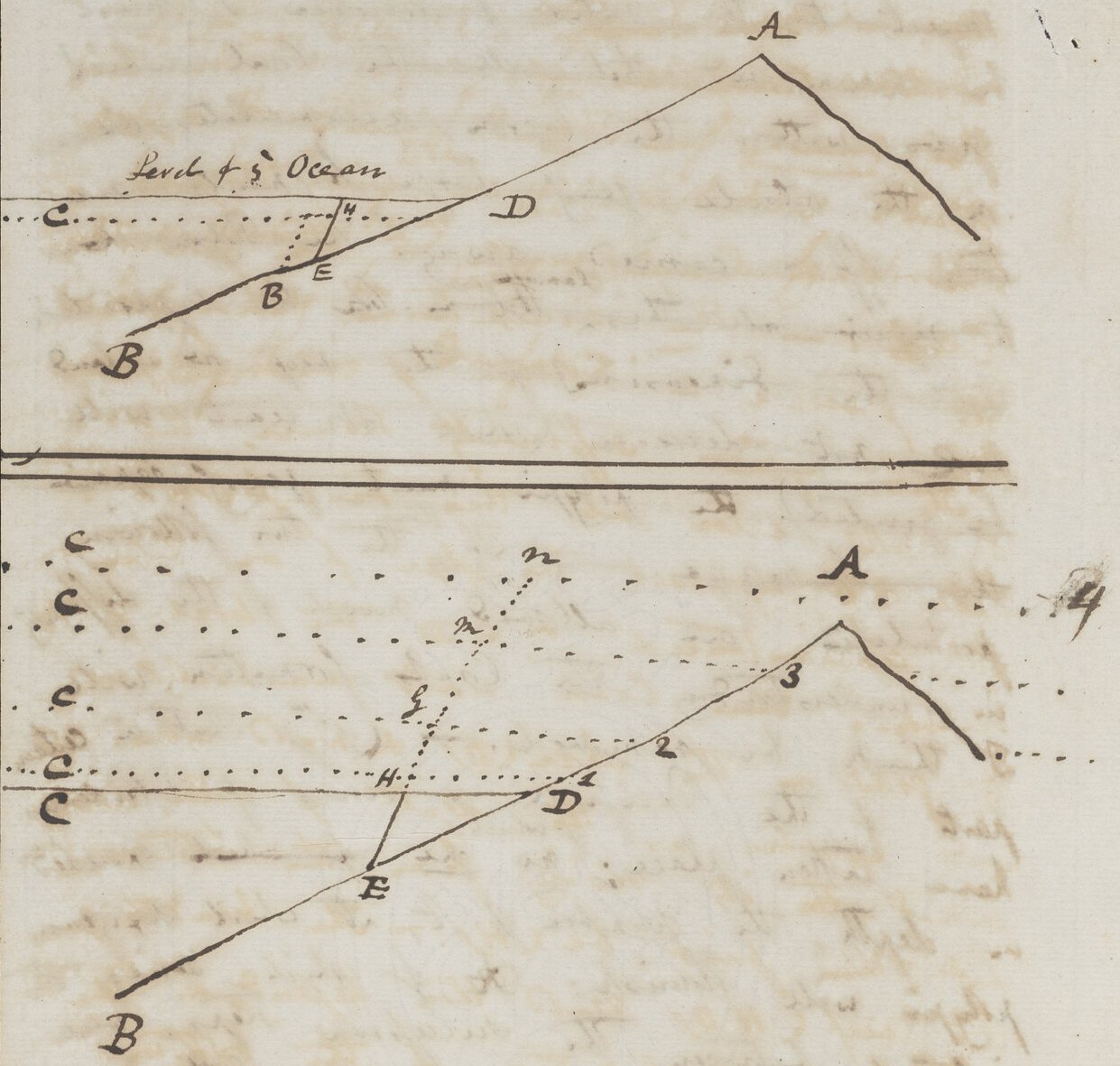
from the heights of Tahiti I was forcibly struck with this opinion.— The mountains abruptly rise out of a glassy lake, which is separated on all sides, by a narrow defined line of breakers, from the open sea.— Remove the central group of mountains, & there remains a Lagoon Isd. I ground this opinion from the following facts.— There is a general similarity in the two cases in the form & size of the reefs; in the two cases, their structure appears identical, we have deep scarcely fathomable water in each case, at a short distance on the outer margin; within is a shallow basin more or less filled up by knolls of growing corall or converted into dry land.—
In the Lagoon Islds. there are some, which do not deserve this title, for they consist solely of a circular reef, of which scarcely a point projects above the water; a whilst others have a more or less complete, but narrow ring of dry land.— In the same
[in margin:] a Such as the Isd. near Turtle I.
'a', 'a', 'Such as the'] pencil.
[6]
1835 Coral Isd. (6
manner in the encircling reefs, although they generally are only ornamented by a few speck formed islands, yet at the fine island of Huahine Ellis states the reef is becoming converted into dry land.* — The essential character of in the one class, viz the of a large encircled Isld. itself dwindles away & becomes ambiguous.— We have the 2 large islands of Raiatia & Taha* (?) included in one reef.— In such cases, as in Gambier Isd. so well described by Capt Beechey, Whylootacke seen by the Beagle, where a group of small hilly islands are encircled by one grand reef, or as in Whylootacke, (seen by the Beagle) when one single one is so situated, it becomes a question in which of the two classes they ought to be arranged.— In the Isd. of Caledonia, as drawn on a large scale in Krusensterns Kruesenstern Atlas, the reef will be seen prolonged at each extremity. & encircling the continuation,
Kruesenstern] pencil clarification of the poorly written same name in ink.
[7]
1835 Coral Isd. (7
the land, beneath the water of the land. It here requires less effort of imagination to remove the high central hills & to leave a perfect lagoon Isd.— Which process this change judging from the figure, it might be believed was actually in process.—
The last argument which I can adduce is the parallelism between the archipelagoes of the two orders, for instance the low Island & the Society ones.— Moreover, this parallelism is found in the direction of the longer axis of the oval figure, which is so frequent in the encircling reefs & low Island:— One is tempted to extend still further this similarity & to believe that there is no difference between the reef which encircles an island, & those extraordinary barriers of coral, which front for so many leagues the coast of Australia & I believe the northern shore of Brazil.— The high encircled Isds. are composed of various geological formations; no
[8]
1835 Coral Isd. 8
doubt ancient volcanic rocks are most abundant, but in Tahiti M. Hoffman found granite.* Mr. Ellis states that in several of the Society Isds. granite, hornblendic rock, limestone & rock with garnets is found.* Forster in New Caledonia describes the prevalent rock under the name of gestell stein,* which I believe to be mica slate.— Hence we may feel secure (if any doubts could ever have been be entertained) that these reefs encircling reefs are not built on the crests of [illeg] submarine craters.— If the proofs of the identity in nature of the two kinds of reefs, are considered as conclusive, in a like manner, there is no necessity that the lagoon Isd. should be based on such craters. I don't not wish to state that such This view will I think, generally be more satisfactory, than the it removes the difficulty of the immense size of the lagoons far exceeding any known crater: & explains the extreme irregularity of figure exemplified in the Radack*
* Ellis 1829, vol. 2, pp. 554-5.
* Forster 1778, p. 27.
* Ratak Chain, in the eastern chain of the Marshall Islands.
[9]
1835 Coral Is.ds 9
& Ralix* groups, described by Kotzebue. Whether we look at these Islands. as having formerly encircled high land, or raised resting on the brim of a crater, it appears to me, we must admit, the suggestion theory of Mr. Lyell, (Vol II Chapt: XVIII) that their present structure is owing to a series of small depressions.— If the ground on which the lithophytes* have built their edifices has not subsided, it must have remained stationary or been elevated.
(a) It being allowed that the corall animal can flourish only at a small depth, it follows, on the first supposition, that all the (a) submarine mountains within this limit had the same height & that not one raised its head above the level of the sea.
On the second supposition, of a series of elevations; these movements over a large tract of ocean, ceased & never exceeded the limits already pointed out.— Now, these consequences from the two suppositions, are so very improbable: (for if they are not so, we
It being allowed…its head above the level of the sea.] paragraph cancelled in ink.
* Ralik Chain, in the western chain of the Marshall Islands.
* This is Darwin's first use of this term. He would have seen it in his recent reading in Forster 1778, Beechey 1831 and Humboldt 1819-29 vols. 6-7.
[9v]
(a) On the first of these suppositions it being allowed that the coral* animal can only flourish at a small depth, it follows that submarine mountains, on which the coral is now growing, reached within the xx limits of such depth, the surface, but yet that not one peak ever raised its head above this sea level.—
xx] marginal pencil.
* Note that the deleted passage on folio 9 used an uncorrected "corall" wheras the verso note twice uses "coral".
[10]
1835 Coral Is.ds 10
might expect to find somewhere a tract of country with mountains of an equal height) that to my mind the evidence of subsidence the only remaining supposition is demonstrative.— No doubt the fourth class of islands, the raised coral rock, is an argument on the other side; but their acknowledged rarity appears to me a proof that they ought rather to be considered as exceptions or irregularities in the prevailing movement. If a gradual upheaval was in progress here, as on the shores of S. America, the coral would afford a more palpable & lasting evidence, than could be expected under any other circumstances.—
Capt. Fitz Roy has discovered an interesting tradition amongst the Low Islanders, that the arrival of the first ship. was followed not long afterwards by a great wave inundation which destroyed many people.— Earthquakes are occasionally experienced here; at Tahiti there happened one which was believed to have foretold the arrival of the first missionaries.
the only remaining supposition] an insertion that substantially changes the meaning of a sentence.
[11]
1835 Coral Is.d 11
I looked in vain on the shores of Tahiti for any sort of evidence of a consequent rise.— In the Polynesian researches traditions (Ellises Researches) there are accounts of deluges,* which evidently were accompanied by volcanic phenomena.—
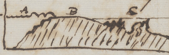
The difficulty in understanding the cause of a reef of living coral, being separated by channels or lakes from the land has not as yet been attempted to be removed. The only explanation which I can offer is (a) chiefly conjectural.a— When at Tahiti I examined the reef.— I found on the exterior margin, a solid broard (30-50 yards?) mound of (B)* coral rock, strikingly resembling an artificial (but low) breakwater on which the surf (A) broke beat with violence.—
The surface of the mound is compact & smooth.— It is slightly curved & dips towards the (C) inside or smooth water of the harbor. |
|
 [sketch]
'(a)', 'a'] pencil.
* Ellis 1829, vol. 2, pp. 42ff.
* The three capital letters in the margin correspond to the letters on the sketch.
* There is a revised sketch on a piece of cream-coloured chain-lined paper with no watermark kept with the fair copy in CUL-DAR41.16.
[11a]
(a) It rests on a belief that the species of coral, most efficient in building a reef, flourish best when immersed in the the surf of the outer breakers on the & that [illeg] their growth is checked by sediment & [illeg] fresh water brought down from the central land.—
paragraph cancelled in pencil.
[12]
1835 Coral Isd 12
smooth ledges of living coral, & that its general inclination is great:— It is only on rare occassions, when there happens to be very little surf & a low tide that the living parts can be seen. Not unfrequently after gales of wind, the ledges (probably overhanging) are torn up & in enormous masses thrown far up on the reef: by this means also the natives know the exterior margin is thus constituted. of The central part of the breakwater is entirely dead; on its surface I only saw the chief production is an encrusting inarticulate Corallina. I was assured The sea, breaking violently on the outer margin, continually ously pumps over in shells sheets the water of its waves.— hence the surface is worn smooth & gently declines towards the lagoon.— However I was assured that on the rare occassions, alluded to, the central part is exposed, uncovered to the rays of the sun, & that this invariably kills (a) the animal, & leaves the lithophyte a of dead rock.
[12a]
(a) There must however be some process by which the th mound is repaired; if once worn away so deeply as always to be covered by the water, this process would immediately take place; the case becomes at once similar to the outer parts, perhaps the Corallinas & other small marine productions may protect the surface.—
[13]
1835 Coral Isd 13
The whole reef may be described, as consisting of two parts: the outer margin of the breakwater, the the solid part of which is higher than all the rest, & a tract of very shallow water which varys in width from 100 yards to a mile. In this low part there are little narrow twisting channels & holes of deep water, & on the other hand many points where the coral reaches to the surface. It is in this still water where an observer as has often been described, may watch the fish gliding amongst groves of variously coloured corals. This part of the reef seldom or never is directly joined to the shores: but there is left channels & harbors where a ship can anchor in a fine sandy bottom.— I imagine it is the fresh water & sediment brought down which helps to prevents these spaces being filled up & likewise perhaps the cause that these reefs are seldomer converted into stripes of dry land than in the Lagoon Is.ds— (a) In the shallow parts the most abundant kind of coralls lithophytes, are stony & branching of generas (as [blank]). Also Fungia & Caryophillia
(a)] crossed in pencil.
[13a]
(a) When such does happen, that part close within the breakwater would from the soft fragments thrown over it, be soonest changed.— there also the water is pure & fit for the growth of some kinds of coralls.—
[14]
1835 Coral Isd 14
Showing them to some intelligent natives I was assured that such kinds never grow on the outside of the reef or compose solid reefs.— From their descriptions, I imagined the prevalent kinds, so situated are such as Porites, Millepora, & some Meandrina & Astræa. Anyhow they appeared to consider that there is a wide distinction in the two cases. Analogy from the habits of all other marine animals would lead one to suppose that the same species would not flourish in two such different localities, as the foam of furious breakers & shallow placid lakes. If this conclusion opinion should be granted, it would be very important; we might infer that those species which build the external solid wall, the highest & most perfect part of the corall rock, will only flourish where the waters break violently.
[in margin:] [hence gaps] / D. L. Beche
M. Quoy & Gaimard, state, "that the species, which constantly formed the most extensive banks, belong to the genera Meandrina, Caryophyllia & Astrea"* & that the Saxigenous polypi increase most considerably in shallow & quiet water. I am not aware whether they suppose, these same species form the outer parts of the reefs. With
[hence gaps]] very faint, possibly erased, marginal pencil.
* De la Beche 1832, p. 149 summarises the findings of Quoy and Gaimard.
[x15]
Coral Isd X15
With respect to the ratio of increase I have a few remarks to offer.— In the greater number of the Lagoon Is.ds from the arguments already used, it is clear no movement of elevation has taken place.— Now Capt. Beechey remarks,* that the strips of dead dry coral, divested of any loose sandy materials heaped upon them are rarely elevated more than 2 ft above the level of the sea.
Now whatever this elevation may be, it is clear, that the highest point of the living coral rock is in any Is.d must be the highest point of living coral — for, as high or higher than the dead. Because the dead lived under similar circumstances & may have suffered degradation.— Now this quantity is so much higher than the level of the ocean & therefore than the waters of the lagoon, which can must afford the nearest approximation to judge by.— Hence the coral, which has formed the strips of dry land, are could not the products have been cherished by those quiet waters, within the outer line of breakers, but rather in the turbulence of the breakers, where a surface above the mean
* Beechey 1831, vol. 1, p. 255: "In the above-mentioned twenty-nine islands the strips of dry coral enclosing the lagoons, divested of any loose sandy materials heaped upon them, are rarely elevated more than two feet above the level of the sea".
[X15av]
(x) This conclusion perfectly agrees with what was visible in the reef of Tahiti. [x indicated to margin of following page]
[X15b]
Coral Isd X15
level would never remain uncovered & exposed to the rays of the sun.(x)— In those cases where true tru coral rock remaining in same pos is above the level of the lagoon, the land must have increased outwards; (a) but as it appears from the extreme depth, beyond the th reef, that this can hardly be a general process, I suspect that the coral rock may often be difficult to be distinguished from a rock of cemented fragments.— Besides the greater absolute height of the coral which grows in the surf, it must be remembered, that yearly gales of wind, tear off large fragments, some of which are tossed on the reef & others must fall down into the surrounding depths. Yearly the Polypus has to replace this damage.— On the other hand, within the lagoon all detritus accumulates, & if as according to M. Quoy and Gaimard, the coral grows there also most rapidly; how comes it that the lagoon is not more commonly filled up? This is the more surprising if we look at the entire section of a lagoon island in Capt. Beechey & see how trifling the inequality of the foundation. [in margin:] XXX
[X15c:]
(a) as appears to have been the case on the Is.d on which Capt. Beechey found the remains of the wreck of the Matilda so very singularly situated.*
XXX really is. And we must also bear in mind that arguments can be advanced to show that the subsidences must happen after long intervals.— such as few proportionate numbers of submerged circular reefs; & again the quantity of detritus heaped up on the dry coral.—
The general tenor of the foregoing facts, strongly urges me to believe that the coral, most effective in forming the solid reef, will only flourish near to the break of the sea.— I will not pretend to conjecture concerning the cause of this prediliction, whether the motion of the fluid, or the quantity of insolved* air is favourable; to the growth or whether the light and heat, which must pervade still shoal water is injurious to the growth of certain their species.—