288
1834 Novr (1) Archipel: of Chiloe.
Chiloe (as far as I yet see) is a range of primitive rock, parallel to the main Cordilleras, which at some distant period has poured forth volcanic rocks. Vide C it is fringed on East coast, being protected from the well of the Pacific by Tertiary strata which have been elevated at distinct periods, great part of which are certainly attributable to the ascent period. — In the north part of Islands the volcanic rocks have been described the primitive nucleus is there only imagined seen to exist herewith their streams at no great distance. V. description Pen: of facing for the primitive rocks P:17 [CUL-DAR35.311]
At Castro I first actually saw it as where blackish mica slate 2360 is seen in all the ravines. (A) — the layers are slightly tortuous, the dip is small, but its direction not easily to be made out; the tertiary formation rests on this; also I saw in one situation at no great distance above the mica slate, a mass of white trachytic rock, with cyst of feldspar & ferruginous patches. — it is divided into tolerably regular pentagonal columns. — I feel little doubt its origin is to be attributed to the same causes, which produced the various rocks near S. Carlos. — Coasting amongst the islands, I did not again see the primitive rocks, till we reached the northern part of Laytec Isd where similar mica slate, with convoluted layers of quartz are coated with mica 2361: this rock composes the whole coast: the laminae dipped here to WSW ∠22º. —
The whole way down the coast to S. Pedro (b), the same sort of mica slate is continued & the direction of the laminae is perfectly very constant
[note in margin] Everything used except this one page & p 17 of other packet
288 verso
(a) X From description it is certain, that granite is found in the interior. —
(b) At Castro, Laytec, & S.Pedro the mica slate contains many convoluted masses & veins of pure quartz
(c) it is far most frequently covered up & fringed by plains of a tertiary formation; the greater part of which would generally be called alluvium. — These have been elevated at &c &c
(a) Jan: 1835.
I thought I recognized a dip to the East: it is found some miles on the coast line to the South: The mica slate is also seen on the shore of the Laguna. de Cacao. — Again on the West coast of Chiloe, we first see it at P. Huantamo & from the nature of the coast there can be little doubt it is continued to the northward as far as Matalqui: at P. Huantamo the cleavage & great plates of quartz were exceedingly confused but near to it, there was some regular dipping to E by N, at about ∠12º.
The mica slate here passed into ampelite, & in its small dip & mineralogical character, manifested the most close identity with the crystalline slates of the Chonos Archipelago. —
289
1834 Novr (2) Arch: of Chiloe
not varying more than half a point on either side of NNW & SSE. the dip was generally as above about 20º. — in one place however it amounted to 60º. — Towards S. Pedro the land rises, saddle shaped hills are formed of considerable elevations. S. Pedro itself by ∠r measurement 2200 feet high. —
The (alluvial) tertiary formations are the common ones along the whole East coast & numerous islands.
The peninsula of Lacuy has been described. I will mention what I have seen beginning at S. Carlos & going round to S. Pedro. It may be previously observed, that with the exception of the land N & S Castro, between P. Tenoun & Detif, the formation would be called alluvium consisting of hardened mud containing rounded & angular fragments of various rocks. These plains are generally lower than those of the more regular formation; as the latter are more frequently capped with much gravel & as we shall show, that successive plains do exist, it seems probable that the "alluvium" plains are more recent & partly formed from the wear & tear of the others. — Of this I have no proof & it is well to remember, how the materials of the formation at Eastern part of St. of Magellan varied from the finest laminated sediment to the coarsest masses of gravel. Indeed, I may here observe, that mineralogical nature of the beds, at this latter place (a), singularly resembles in many respects the lower plains of the Archipelago of Chiloe. —
Shortly after leaving S. Carlos, we meet an horizontally stratified fine soft sandstone, containing layers of pebbles
289 verso
(a) It would seem probable that sudden alternations from fine sediment to coarse gravel or "alluvium" bespeaks deposition in a shoal sea with strong currents. — In the mouth of the Sts of Magellan the soundings varied much & suddenly. —
290
1834 Nov (3) Archi: of Chiloe
Beyond this there are low plains from 100 to 200 ft high composed entirely of gravel in horizontal lines, the whole way to Chacao:
From this place as far as P. Tenoun, wherever I examined the cliffs there was no essential difference.
The Islands of Chauques, seen at a distance appeared rather finer grained material
At Port Tenoun we first meet with fine grained smooth, highly laminated, indurated sandy clay (or clayey sandstone, becomes greasy with water) it is [illeg] like the specimen (2056) from C.Virgins. (a) —
On northern & western shore of Quinchao, we have same substance but the layers are curiously convoluted & arched as if over doom running NNE & SSW.
At P. Relan, there is a coarser sandstone in horizontal layers. — The plains in this district certainly are higher from 2 to 400 ft. —
Within the creek of Castro, the formation is rather various: near the town this same substance is found, & close by it a mass of alluvium lying immediately on the mica slate: lower down curved layers of same substance are covered by an irregular inclined (from currents) bed of a hard pale-grey sandstone 2355, composed of broken crystals (volcanic?). In another place a very soft yellow sandstone (like 2354) is extremely abundant (b) it contains globular concretions of hard, grey sandstone & numerous small bits & layers of black altered wood on lignite.
by varying [illeg]
On the NW shore of Lemuy, we have precisely the same formation 2353; but it is remarkable from the quantity of lignite: every where there are detached pieces, which
290 verso
(a) Specimen (2357) from extreme point of Lemuy is rather a more argillaceous variety of this sandy clay. —
(b) I have omitted: that this substance passes suddenly into different varieties, becoming finer grained & a brighter yellow: at other times into a greenish clayey sandstone: it is traversed in all directions by ferruginous veins. — In this latter respect, in the concretions & yellow — sandstone strongly resembles the beds of the Peninsula of Lacuy (also is containing volcanic debris ??). To which it is probably contemporaneous. —
Hence approximation to age of this volcanic range parallel to great range of Andes
291
1834 Novr (4) Arch. of Chiloe
are more or less flattened. The thickest bed must be nearly two feet, in its structure resembles wood (2350) 2350. — The variety of lignite (2351) 2351 is also abundant: I was interested by finding in another specimen (2352) 2352 clear traces of leaves. — Are these compact lignites composed of a multitude of leaves, compressed together & thus altered? The question is of importance in relation to the formation of coal. — Many of the detached pieces, I think must have been wood; perhaps the more regular & thin layers or beds are leaves. —
The cliffs of Lemuy was composed of the yellow sandstone 2353 contain few lines of scattered pebbles: there was also a bed of more indurated black-grey sandstone. 2356 — The formation is traversed by numerous ferruginous plates or veins. it is capped by thick bed of agglomerated granite.
On the beach there was many large fragments of silicified wood 2348, lying as I have so frequently noticed in many parts of S. America in rounded blocks. (a) — On the shore of the main-island (facing Lemuy), we have the same sandstone 2354, with lignite, capped as before with the gravel & fragments of lig petrified wood on the beach. — I was, much pleased, at last to find the silicified wood in situ; a large trunk, thicker than my body, throwing off branches, stood out of the sandstone (from weathering) in the very position it was silicified. —
Parts of it were more sandy, than solid silex specimen (2349) 2349. — I ha noticed, that the
291 verso
(a) One of the pieces was had been penetrated in every direction by a Teredo & was in this state silicified. —
292
1834 Novr (5) Arch: of Chiloe
central parts of all the blocks were black & the structure of the wood scarcely visible. — I presume putrefaction commenced, before the silex had taken a model of the structure. The form & structure of the wood is beautifully distinct. — transparent quartz filling up the vessels.
All the specimens, I examined, belonged to the same wood. — It is a very curious fact, that the very same matrix, in the same locality & in same geological formation has been able both to silicify wood & convert it into lignite.
Has the nature of some particular wood or tree determined the former process? the blackening in the centre of the blocks perhaps points out the tendency even in these to pass into lignite.
I feel the more interest in finding this silicified wood in situ, because the inhabitants here, as in all parts of S. America, are convinced, that these masses are of recent origin.
The land behind Castro rises to about 800 feet. — (aestimation): & further in the interior the paps of M. Cucao are said to be the highest land in Chiloe: they are probably either of primitive or volcanic nature; there can be little doubt that all the above vegetable matter flourished, on these hills, when they were low islands in the same luxuriant manner, as at the present day. —
Near to the spot, where I found the petrified tree, there was a small patch of a concretionary- layer of hard (crystalline calcareous?) grey sandstone which contained layers of shells. — There were few
292v [blank]
293
1834 Novr (6) Chiloe
in number, difficult to extract & altered in their nature. These are the only shells, I could any where find in the tertiary formation of Chiloe 2339 ... 2347. they are far too few to judge of its age.
I can only say, that one of the commonest a Tellina is unknown to me. — The mineralogical nature, with its concretions &c resembles those of different ages in southern parts of S. America; from this, excepting when in pretty close proximity we can hard form no conclusion. We may however suppose it is not "recent". —
It appears to me, somewhat curious, finding in a patch of 3 or 4 yards square shells, & in no other locality. — We cannot believe shells only lived in this patch (shells of quite different genera), but rather they have been here only preserved by the chemical process, which formed the concret: sandstone. This is a conclusion which I drew at Eastern mouth of Sts of Magellan, from finding abundant organized beings amongst the loose stones & mud, but never where these have been uplifted into dry land & subsequently exposed. — Extreme slowness of deposition might possibly explain this fact, which may be of extensive explanation application. respecting the absence of fossils in certain formations. —
At P. Yal we have same sandy laminated clay capped with gravel, as before, which passes into a mass of "alluvium" at P. Detif. (extreme S. point of Lemuy) we have beautifully horizontally belo stratified & laminated of the sandy clay 2357; with here & there a pebble: & capped with gravel: there were alternations
293v [blank]
294
1834 Novr (7) Chiloe
of colour from every 1/2 to 1/2 inch, the cliffs were about 200 ft high. — The junctions of the varieties of color, were as fine as inlaid carpentry & the plates most perfectly even smooth. I must suppose the effect of after arrangement & not immediate deposition, in same manner as on a larger scale whole beds are formed by the expansion & union of sphaerical concretions. —
At P.S. Aytui there were alternations of almost loose sand & gravel. — In the neighbourhead of Isd of Tanqui & P.Chagua & eastern side of Isd of Caylin there was (so called) alluvium (mud hardened mud with variously sized pebbles).
The plains here were generally At P. Chayuao however this alluvium passed into mud without pebbles, & the laminated sandy clay. — there was a minute fragment of a Cytheraea in one part. — The plains generally in this southern part were lower than the central — but at this point they were about 300 ft. — the lower parts were capped by gravel, which had worn hollows in the soft sandy clay & was clearly of a distinct origin. —
Passage into Boulder formation
South of Caylin, as I have said, we only meet the primitive formation of mica slate. —
We thus see, the distinct tertiary formation with fossil shells & lignite, which extends over the middle part of the Archipelago, passes both to the North & South through the laminated sandy clay into a mass of alluvium; & then there are lower plains of agglomerated gravel (a) which perhaps are of a more recent origin. The consideration of the early form of
294 verso
(a) All the beaches at the present day are composed of shingle. — likewise many of the extensive flats: these if elevated would begin to form another series of low gravel plains.
Insert in Patagonia
295
1834 Novr (8) Chiloe
the land, anterior to the last 6 or 700 ft elevation may explain part of this. The high land behind Castro would then have formed a small island (a) & the rest of the archipelago an open sea. — Would not the finer deposits collect more rapidly under the lee of this island? would not, during the successive upheavals, this part be more protected from the encroachments of the sea? — Would not the gravel & coarser materials collect towards the points unprotected points of the island? — Hence the present arrangement.
Mere inspection of the chart will show, where there are many creeks & inlets, the tertiary formation is present from Lacuy to Caylin. — The seaward face is quite clear of this border. —
The formation being so much broken up into islands & bays might well happen, during the upheaval, when they were only shoals & in rather exposed places. — The tides of the present day are also very rapid; the extensive reefs from every promontory show how much has owing to been removed by their influence. — It is not improbable that some of the islands have a nucleus of primitive rocks, which determined their deposition & perhaps may account for the alledged great depths of some of the channels. —
With respect to the elevation of the land, & the form impressed on it, during the step-like retreat to of the ocean. I did not see much;
295 verso
(a) The high primitive land of S. Pedro & to the North of it would form a lower island, & perhaps by its protection, caused the finer deposits of P. Chayhuao near Caylin. —
296
1834 Novr (9) Arch: of Chiloe.
In E & W sections of the plains, I could see a slight dip to the eastward; which is, as might be expected. — This line was occasionally
[sketch] A B
notched as at (A): I also saw a valley or rather a gap in plains some way inland & at a considerable height, formed as at (B). (a) — where probably the sea, at a former period, form leveled the bottom. —
In front of the high land, with an irregular waving outline, which has been mentioned as occurring behind Castro, there are three very distinct terraces or small plains. — the lowest is perhaps about 100 to 200 ft; the highest 500. — they have an inclination towards the present creek of Castro. V. Drawing — Their appearance is rendered tolerably manifest by occurring on each side the valley of Gamboa. — These terraces & the notched line (A) belong to the same class of facts so much observed on the plains of Patagonia; where each escarpement has been old sea coast. —
In several places near Castro, at the same height of about 30 feet above high water mark, there were large banks of comminuted shells. — these were chiefly Venus & Mytilus. — the abundant sort of shell, was lying on the present bank. (b) — Similar beds occurred in same position at Lemuy. — Generally it is extremely difficult to ascertain, whether the shells have been carried up the inhabitants, where the staple food is shell-fish or left by a retiring sea — In this case however there could be no
296 verso
(a) It may perhaps be worth notice the frequency of circular coves, joined by a narrow mouth with the outer waters. — They vary in depth; some being nearly silted up or elevated: They are generally formed by a broard grand spit running out in the line probably of former sea quiet water, where a bite in the land caused an eddy. — [sketch] The dotted line shows the spit, within which an eddy might formerly have been existed. — When these are elevated into a continent they would have a curious lacustrine appearance.
The littoral shell of Chili. (b) — Concholepas, here gives way to Venus. — it is however present, but not in numbers. —
Assuming which is near the mark a regular pentagon 11 ft on each side, height 13 ft. Xb next page. The contents will be 2708 cubical feet; the celebrated one, the largest known, near Geneva is 20 x 15 x 10 = 3000 ft. — Agassiz says 50,000!!!
When the land is elevated, Chiloe separated by a broard valley where present inland sea is, may present as inexplicable case, with respect to Boulders as the Jura does in front of the Alps.
297A
Castro
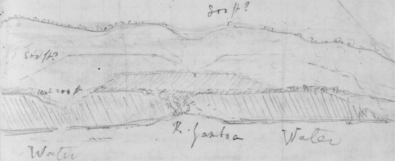
[sketch of terraces at Castro, Chiloe] 500 ft? 800 ft? 160 to 200 ft Water R. Yamboa Water
Perhaps gneiss dipped to NW ؟Sea-shells — extensive formation:
This leaf was excised from the Port Desire notebook, pp. 77-78.
297A verso
sea-shells. — extensive formation: ؟ Perhaps gneiss dipped to NW small ∠???
The dust of S. Carlos, came from the Corcovado, very thick, whole island, in 1827? & 14 miles to Seaward Douglass:
carefully reexamine Valparaiso shells
Point nat — Peninsula Lacuy shells high up Douglass
a doubt about Chacan Boulders
one strong shock & three days & dust band Particulars & date of 1831 of small ones great Earthquake: shortly afterwards in activity Stone off S. Carlos. gradually was nearly laid dry & gradually the water regained: & frightened people [illeg]
297
1834 Novr (10) Arch: of Chiloe.
doubt. (a) In my notes to S. Carlos, I have attempted to show the land to this day as rising, a proof of it exists in the names of the places. — "Huapi" in the Indian language means islander; now many peninsulas, joined by low land have at the present day the affix Huapi affixed to them. — The inhabitants state they were formerly islands. — Suitras Huapi Laing & Huapilinao &c &c
Boulders
The whole of the East coast of Chiloe & its islands are strewed over with an extraordinary numbers of large fragments of crystalline rock; for the greater proportion bring a fine granite. They are very little rounded, not more than the weather effects or fragments at the base of a mountain. — They occur not only on the beach, but occasionally at some height & a few are imbedded in the (so called) "alluvium" formation. They occur equally on promontories (an argument that the present tides are not slowly moving them, as Mr Lyell suggests) & in the quietest coves within the archipelago. — I at first believed they had come from the Cordilleras, which are composed of syenite & granite; but as, it appears granite is found in Chiloe, it is impossible to be certain of their origin.
An argument for the Cordilleras origin; is that at S.Carlos they are not present & that near Castro, where mica slate is present the number of such rocks was not particularly prevalent. Anyhow even on the supposition of Chiloe, they must have traveled for several miles, particularly in such places as at Chacao. —
One block of granite on north shore of Lemuy, in centre of archipelago was immense like a house, very angular in its outline: it was pentagonal, mean girth 52 feet (about 10 feet each side) how much buried in gravel I do not know (b), but mean height
297 verso
(a) Some shells I found at considerable elevations. I cannot possibly say to which of these causes to attribute their presence. — I have no doubt but what more than 30 ft have been elevated in the Recent period. — but have no proof. —
(b) 13 feet, one point being about 16 feet: Generally speaking they lie on the surface of the gravel or sand. — one at Chacao. was a rectangular oblong, 15 ft x 11 ft. x 9 ft high. & with the base quite flat ∴ angle finer, quite at angular.
there was another nearly as large. And one called the Piedra blanca. is said to be still larger. I did not see it. — There were very many. in all parts 2/3 to 1/3 as large as these enormous masses. —
These fragments have in common with others I have described: the angular shape: the connection with a mass of alluvium, where however the proportion bears no proba of included fragments bears no probable (even allowing for wear & tear of cliffs) proportion with the scattered ones: many being rested above tidal influence: being clearly of marine transportal: absence of other signs of Diluvial action, more than what they themselves offer.
It appears to me certain that present tides have but little influence on them, excepting perhaps by removing substances from beneath or around them & thus allowing their gravity to cause their descent. — During the retreat of the sea. might they not from this cause, follow the beach?? — However these
No. of action of gales &c certainly would counterbalance any such slight tendency??
[sketch] by immense removals I can imagine rocks to be propelled.– But how could that apply at P. Famine? The numbers & boulders on beaches can be understood by gales driving them before them, as front of cliff is consumed [sketch] All those at B would move on to A + those included in formation between A & B = The great difficulty which yet remains is how, during deposit of fine sediment or gravel, every now & then a great boulder was carried out + to sea — subsequently to be exposed on a beach.– The transportal of boulder with fine sediments as at Navedad, Chili is to me quite inexplicable.–
'with the base quite flat ∴ sides angle finer, quite at angular.', 'by immense removals… quite inexplicable.–' and sketches in pencil.
298
1835 Jan: Chiloe (11)
I have stated, that I felt some doubt, concerning the original site of the very numerous boulders on the East coast of Chiloe. If they had come from the Island itself, they might be expected to be found equally on either coast. Now on the very little which I saw of the West side near Cucao there were none. — The Harbor of St. Carlos, is not a fair case, because no high land, excepting volcanic & perhaps therefore recent separates it from the East coast.
The Boulders are however by no means nearly so frequent. — the only place, where they were abundant is at the northern point part of Peninsula of Lacuy, in the direct line of the Straits of Chacao.
There are some remarkable circumstances, concerning the situation where they are found. By inspection of the tracing of the Peninsula, the NE Headland is seen to be joined to rest by a narrow low neck of sandy soil, almost crossed by a shallow creek & lake. — It is in this space, between the high land on either hand, the boulders are found; they are very large; one fully as big as the 2nd large one of Chacao; those I examined are of syenite, of the same variety, which Mr Douglass1 informs me compose the Cordilleras near Reloncavi. — I feel no doubt they have traveled from that source a distance of [blank] miles. —
The northern part of the headland is composed of fine sedimentary strata. (which are minutely described). These a little to the South, appear to pass into an "alluvium" almost composed of gravel. (a) — A dotted line in tracing shows the separation. —
1 Charles D. Douglas, surveyor and resident of Chiloé.
298 verso
(a) What is the distance from the Sts of Chacao to the Cordilleras? it is not so far as fragments have traveled in the plains of Patagonia?
299
1835 Jan: Chiloe 12
The land composed of the gravel is full as high as rather higher than that of the sedimentary beds. On the South side of the valley at (Z) we also find some gravel. —
In Some of the Boulders are yet seen imbedded in the gravel & one of the very largest is lying on the surface at an elevation of at least about [150] ft. —
I suppose all the boulders have been once imbedded in the gravel; anyhow we see that the latest period of arrival of one of the largest was when this valley was a deep channel. — The fact of the abundance of boulders in an ancient channel recalls to mind the precisely similar fact in T. del Fuego.
My opinion concerning these boulders, is that a current in the sea, when all the strata were depositing determined a band of g the deposition of a band of gravel & boulders. This would be (according to analogy of present day) the deepest part. Hence during the gradual upheaval of the land, this would form a channel, by which the greater part of the gravel would be removed leaving the boulders (for what I know to the contrary, the current might also bring some). And ultimately a dry valley would be formed. — If this reasoning is true, it shows, how insensibly & how dependently of on regular cause the face of the land assumes its present form. —
An ancient current forms has a submarine channel, which first forming, during gradual upheaval, an outlying shoal, then an island, & ultimately becomes a dry neck of land, connecting the island with the mainland. —
It may be urged, I have not traced the actual passage from the fine sediment to the gravel (a), but have only judged from the frequency of
299 verso
(a) this occurrence of the East coast, and therefore that a sudden rush debacle, bearing gravel & boulders may have removed formed & filled up a grand channel in the sedimentary finer sediments: if this did happen, it was when the whole was beneath the sea. for the land of gravel is higher than that from of the other class (moreover the gravel appears regularly deposited). & therefore the subsequent gradual steps in the change of form of land must have been similar. —
I am afraid the above is not very clear: my object is to show that a this peninsula of the present day is the result of very remote & regular causes, viz whatever at formerly determined the direction of a stream of tide. The transportal of boulders with gravel is not here touched. — We know it such takes place. —
300
1835 Chiloe
Mr Douglass in a letter from Chiloe informs me,1 that he has seen many large blocks in different plains, in the Isd both high up & on the beach. — But never excepting one imbedded in the cliffs (Mem: such sections are not so very numerous) which was at P. Chouan estimated 80 ft above the sea. size about 9 ft into 4 ft. depth unknown. buried in the cliff. — Mr Douglass also says, that in front of Ch Caucahue on Ancur beach he measured a block of fine grained granite. — length 18 ft. height on one side 9 ft: 4in. circumference 4 ft above the ground 5 ft. — Cross measures over the middle were: 31ft 3, other at right ∠r to this 26 ft. —
Another block lying on the surface, of ground, estimated 200 ft above the sea. — At P. Lobos Caucahue dimensions 9x4x6 ft. — coarse grained granite. —
1 Letter from C. D. Douglas 24 February 1835, Correspondence vol. 1, pp. 430-1.
300v [blank]
301
1835 Jan: Chiloe 13
In a section of the island, on the road from S. Carlos to Castro, in the first half the country is traversed by remarkable number of steep valleys: after leaving the volcanic rocks, we find nothing but yellow clays, soft sandstone (or rather agglutinated sand) gravel, by itself or arranged in lines, in loose sand. In the latter half the road passes over plains, the last of which corresponds perhaps to the 500 ft one mentioned as seen at Castro, from this part of the road, the highest land in the island (perhaps from 800 to 1200 ft) is also seen to consist of a plain. —
Everywhere a ravine showed the nature of these plains, they were composed (sometimes seen to the depth of 200 ft) of the materials above mentioned; the clay however seems more generally confined to the neighbourhead of the volcanic rocks). — The materials are almost invariably arranged in horizontal lines; from their loose texture & coarse structure, they resembled exactly what is generally called alluvium, (for instance the general covering of Shropshire). —
Now the country consisting of plains & the arrangement of materials being alternately coarse & finer sediment in horizontal lines. The present state of things can only be accounted for by marine deposition (lakes are here manifestly out of the question). — The deposit (a) being in its appearance so exactly that of a river in its nature (but not form) is interesting. — it is a step to a conclusion, which I am strongly induced to believe, that nearly all the so called grand deposit of alluvium are of a marine origin. — Being the superior parts
301v
(a) Near Castro, there was a regular white soft fine sandstone, which certainly had the appearance by which an aqueous deposition is generally recognized.—
302
Jany 31 1835 Chiloe Catiman
upper T=T'
t'=63 t=65
β'=30.095 β=30.469
β=1.483858
β'=1.474894
D=0.005364
=7.729489
H=4.810480
C=0.000200
2.540169
= 346. ft + 4 feet near level of tide. —
= 350 ft.
Bed of Ostreae & Venus
302v [blank]
303
1835. Jan: Chiloe 14
last deposited by the sea, before the land rose from its bosom. — The interior parts of Chiloe, may be considered as almost entirely composed of the above deposits. —
As far South as Chonchi, on the coast below Castro, in very many places a beach of comminuted shells might be seen; it consisted of a thick mass with scarcely any of the shells perfect. I recognized however the species now found on the coast. This beach might, I have no doubt be traced in nearly a continuous line. In some parts I estimated its elevation at about 50 feet at high water line. from this to 25 ft was common: in fact the land from the latter height to the waters edge might all be considered as a beach. — The difference in height I by no means attribute to different elevation, but only to different parts having been preserved or removed originally existed; accordingly as we now see in one spot a greater accumulation of shells than in another. —
Near S. Carlos, at the Pudeto I saw such at a beach perhaps less than 25 feet high, but considerably inland of present sea. —
Jan. 31st
At Catiman in the harbor of S. Carlos, I was informed by a resident, that there was a great bed of shells up in the wood: They consisted in an immense mass of the Ostreae & Venus (2535), now so common in the cove at the foot of the hill. — The shells were buried & covered by black damp vegetable mould, in which great trees were growing. — The hill consists of a patch of table land, with steep sides, it is on these & beneath two or three feet of very damp vegetable mould the shells lie packed: The man found in a bed lower down (2526) (where the peninsula must have been an island) a deers horn (a). I presume of the
303 verso
(a) of the small deer, now common on all the islands (puda of Molina?).1 —
The height of the hill, which seems to have formed once a part of a plain is 350 ft above mean level of tide (Barom:): Perhaps It is probable it is a coincidence, but the 350 plain was the one of greatest extent in the plain of Patagonia. — Besides the absolute proof this affords of the time of elevation of this coast: & besides the curious preservation of shells under such very unfavourable circumstances in so perfect a strata: there is another point of interest; the rarity & difficulty in finding, such shells as a proof of elevation: We have abundantly seen an old beach about from 25 to 50 ft above level of sea; but above this shells appeared entirely absent, so that I came to the conclusion, that either this side of America did not experienced the same horizontal elevation with the East side, or that all signs must have disappeared. — Yet here come an undoubted proof at an elevation of 300 ft higher than in any other locality I have seen (The old man said, he had seen such shells in some other part of the forest). —
I may here notice, that the local grouping the local grouping of shells remains the same after long intervals. Those species of the existing groups which we now find in particular localities, are those found on the elevated land in this neighbourhead. — Thus here the Venus & Ostreae are now the most abundant shells near the coast we find them so at an elevation of 250 ft: the same relation holds good with the Mytili & Patella on the coast of Patagonia. — the Concholepas, Fissurella & Donax of the coast near Valparaiso. —
To what an epoch does this consideration lead the mind when in the older strata, not only is the local habitation of species altered; but the species & even genera are changed.
1 The wild deer of Chiloe (Puda puda). The heumul or southern Andean deer (Hippocamelus bisulcus) was first described and named Equus bisulcus by Molina 1794-5.