[page] 415
XXVII.—On the Distribution of the Erratic Boulders and on the Contemporaneous Unstratified Deposits of South America.1
By CHARLES DARWIN, Esq., M.A., F.R.S. and F.G.S.
[Read April 14th, 1841.]
__________________
CONTENTS.
| 1. |
Description of the Boulder Formation | in the Valley
of the Santa Cruz. . . . . . . . . . . . . . . |
p. 415 |
| 2. | ______________________ | in Tierra del Fuego and the Strait of Magellan. . . . | p. 417 |
| 3. | ______________________ | in the Island of Chiloe. . . . . . . . . . . . . . . . . . . . . . | p. 423 |
| 4. | Remarks
on the Glaciers of Tierra del Fuego and on the transportal
of Boulders. . . . . . . . . . . . |
p. 427 | |
1. Boulder Formation in the Valley of the Santa Cruz.
DURING the survey of the shores of South America, southward of the Rio Plato, by Capt. FitzRoy in H.M.S. Beagle, I did not meet with any boulders on the eastern plains of the continent until we arrived on the banks of the river Santa Cruz, in lat. 50° 10' S. Nor did they occur there near the coast, but were first noticed in ascending the river at the distance of about 100 geographical miles from the Atlantic, and 67 from the nearest slope of the Cordillera. Twelve miles further west, in lon. 70° 50' W., that is, fifty-five miles from the mountains, they were extraordinarily numerous; consisting of compact clay-slate, feldspathic rock, a quartzose chloritic schist, and basaltic lava; and they were generally of an angular form, and many of them resembled fragments of rock at the foot of a precipice. The size of some was immense: I measured a square one of chloritic schist, which was five yards on each side and projected five feet above the ground; a second, which was more rounded, was sixty feet in circumference, and stood six feet above the ground; how much of each was buried beneath the surface I could not ascertain. There were innumerable other fragments from two to four feet square. The vast open plain on which they lay scattered, is 1400 feet above the level of the
1 See the abstract of this paper in Darwin 1841.
[page] 416
sea; its surface is somewhat but not greatly irregular, and the inequalities appear to have been caused chiefly by the denudation of loose matter from an irregular field and hummocks of lava. The plain slopes very gently and with much regularity to the Atlantic, where the sea-cliffs are about 800 feet high; it rises somewhat more abruptly towards the Cordillera, near which its height is above 3000 feet. The Cordillera in this latitude are not very lofty, the highest pinnacle being only 6400 feet above the level of the sea.
The accompanying section (Fig. 1.), exhibited on the banks of the river in the
Fig. 1.
Surface of plain, strewed with great angular erratic boulders, 1400 feet above the level of the sea.
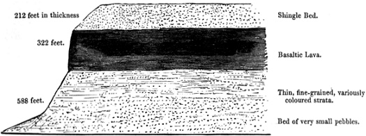
River Santa Cruz: here 280 feet above level of sea.
longitude above referred to, will give a sufficient idea of the composition of the plain on which the boulders lie. The upper bed is 212 feet in thickness, and exhibits indications of being coarsely stratified. It is composed of well-rounded shingle with great angular blocks strewed on the surface, and probably imbedded (for owing to the state of the section I was unable to ascertain this point) in the whole upper part of the stratum. The shingle bed is continued without interruption to the coast, and is there certainly of submarine origin. From its general similarity throughout this space, I have no reason to doubt that the whole was accumulated under similar circumstances. The lowest bed represented in the section is composed of minute pebbles of the same varieties of rock, with the exception of those of basaltic origin, as the great boulders on the surface. The contrast in the means of transportal from the same source, afforded by the regularly sifted minute pebbles of the lowest bed and the huge angular fragments of the uppermost, separated by a great stream of lava and a deposit of fine sediment nearly 500 feet thick, appears to be worthy of notice.
The valley in which the Santa Cruz flows, widens as it approaches the Cordillera, into a plain, in form like an estuary, with its mouth (see map, Pl. XL.) directed towards the mountains. This plain is only 440 feet above the level of the sea, and
[page] 417
in all probability it was submerged within, or nearly within, the post-pliocene period. I am induced to form this inference from the presence of existing sea shells in the valley, and from the extension far up it of step-like terraces which on the sea-coast, certainly are of recent submarine origin. Round the estuary-like plain, and between it and the great high plain, there is a second plain, about 800 feet above the sea-level, and its surface consists of a bed of shingle with great boulders. In this part of the valley, namely, between thirty or forty miles from the Cordillera, there were, in the bed of the river, boulders* of granite, syenite and conglomerate, varieties of rock which I did not observe on the high plain; and I particularly noticed that there were none of the basaltic lava. From this latter fact and from several other circumstances, more especially from the immense quantity of solid matter which must have been removed in the excavation of the deep and broad valley, we may feel sure that the boulders on the intermediate plain and in the bed of the river, are not the wreck of those originally deposited on the high plain. These boulders, therefore, must have been transported subsequently from the Cordillera, and after an interval during which the land was modelled into the form above described. Those on the lowest plain must have been transported within, or not long before, the period of existing shells.
I have said that the first erratic block which I met with, was sixty-seven miles from the nearest slope of the Cordillera; I must, however, record the case of one solitary rounded fragment of feldspathic rock lying in the bed of the river, at the distance of 110 miles from the mountains. This fragment was seven feet in circumference, and projected eighteen inches above the surface, with apparently a large part buried beneath it. As its dimensions are not very great, we may speculate on some method of transportal different from that, by which the plain near the mountains was strewed with such innumerable boulders; for instance, of its having been imbedded in a cake of river ice. Its solitary position is, however, a singular fact.
I met with erratic boulders nowhere else in Patagonia: Captain King, however, states, in his "Sailing Directions,"1 that the surface of Cape Gregory, a headland of about 800 feet in height, on the northern shore of the Strait of Magellan, is strewed with great fragments of primitive rocks.
2. Tierra del Fuego and the Strait of Magellan.
The eastern part of Tierra del Fuego is formed of large outliers of the Patago-
* I may observe, that it can be clearly shown (Journal of Researches, p. 216) that the river itself, although large and rapid, has scarcely any power in transporting fragments even of inconsiderable size.
1 King 1832.
[page] 418
nian formation, fringed by deposits of much more recent origin, the height of which varies from about 100 to 250 feet. These lower, irregular plains have been elevated within the post-pliocene period. They consist of fine-grained, earthy or argillaceous sandstone, in very thin, horizontal, but sometimes inclined laminæ, and often associated with curved layers of gravel. On the borders, however, of the eastern parts of the Strait of Magellan, this fine-grained formation often passes into, and alternates with, great unstratified beds, either of an earthy consistence and whitish colour, or of a dark colour and of a consistence like hardened coarse-grained mud, with the particles not separated according to their size. These beds contain angular and rounded fragments of various kinds of rock, together with great boulders. At Elizabeth Island, within the Strait, there are good sections of this deposit in cliffs 150 feet high, and composed chiefly of whitish earth, with fragments of syenite, greenstone, feldspathic rocks, clay and hornblendic slates and quartz, most of which do not occur, in situ, in the neighbourhood. These fragments are generally arranged without the slightest trace of order,—large and small, angular and rounded being close together; but in some parts of the cliff, the mass is divided by beds of stratified shingle, and these are most frequent in the upper part,—a fact which I observed in other places.
Few of the fragments much exceed in size a man's head, but there are numerous large boulders on the beach. In the cliff at Cape Negro, which is close to Elizabeth Island, and is of the same height and of nearly the same nature, I saw a great boulder imbedded. This deposit at Nuestra Señora de Gracia is rather finer grained, and contains fewer fragments; some of which are perfectly rounded, some quite angular; and a single one, of considerable size, is often imbedded by itself in fine-grained and fine-laminated matter. I here, also, observed a boulder at least four feet in diameter, projecting from the face of the cliff. In a neighbouring cliff, a whitish mass fills up hollows in an underlying finer-grained bed. North of Cape Virgins, close outside the mouth of the Strait, the cliffs are between 200 and 300 feet in height; and they consist of an argillaceous sandstone in horizontal laminæ, as fine as roofing-slate, which in several places is interstratified with two or three beds of the coarse nature just described, each stratum being from five feet to twenty thick. These beds often thin out and become curvilinear at each end. The imbedded fragments are of the same nature and shape as before mentioned; and their parent rock cannot be less, and probably is considerably more, than 120 geographical miles distant. In the other cases above described, the distance must be at least sixty miles. The mountains, from which they all probably came, lie west and south-west.
The numerous boulders before noticed on the beach at the foot of the cliffs on Elizabeth Island, consist of the same varieties as the smaller imbedded fragments,
[page] 419
and are from one to four feet in diameter; the outline being irregularly angular, with only the edges blunted. In the other places above mentioned, and likewise at the base of the mountains on the line of coast extending south to Port Famine, boulders are numerous on the sea-beaches. Although I saw only two in the cliffs, yet as the boulders do not, as far as I was able to observe, occur scattered on the surface of the ground, and as a large area has evidently been denuded, I concluded that most of the blocks were originally enclosed in the deposit, and that after they were washed out, they had been driven onwards by the surf during gales, and collected at the foot of the retreating cliffs. At St. Sebastian's Bay, however, on the east coast of Tierra del Fuego, this explanation is scarcely applicable, for many gigantic boulders there lie in a protected position at the base of a naked cliff about 200 feet in height, and entirely composed of thin strata of fine-grained sandstone, with a few layers of small, well-rounded pebbles. As it is very improbable that the boulders were ever included in a deposit of this nature, we must suppose that they were originally thrown down either on the surface or in a thin superficial bed, which has subsequently been removed. I may specify, that one of these boulders, composed of syenite and shaped somewhat like a barn, was forty-seven feet in circumference, and projected about five feet above the sand-beach. There were many others half this size, and they all must have travelled at least ninety miles from their parent rock.
The position of the boulders in St. Sebastian's Bay is, in another respect, interesting; for the form of the land clearly shows, that long anterior to the total amount of elevation attested by upraised recent sea shells, a wide channel (indeed, introduced in all the charts before the voyage of the Beagle) connected the middle part of the Strait of Magellan with the open sea. During the same period, a very low neck of land near Cape Negro, now strewed with boulders and bordered by cliffs of the unstratified deposit, must have formed a straight channel between the great land-locked bay called Otway Water, and the eastern arm of the Strait of Magellan. Shoal Harbour, which lies in this line, is scattered over with enormous angular fragments of rock, projecting from five to eight feet above the level of the sea, and giving to it a singular appearance. The unstratified beds of hardened mud and whitish earth, containing a few boulders and numerous smaller angular as well as rounded fragments, occur only in the neighbourhood of the Strait of Magellan, and are probably connected in their origin with the existence of an ancient channel which had nearly the same direction with the present one: so also it is evident, that the distribution of the numerous great boulders now lying on the surface (whether or not all were originally imbedded in the unstratified deposit) is likewise connected with the course of formerly existing sea-channels. The currents off Cape Horn set almost constantly from the west, as is known to the cost of
[page] 420
all those who have to double it; hence they probably set in a similar direction through the above ancient channels, when more open and less crooked than the Strait of Magellan now is. It is in accordance with this circumstance, that, in the districts just described, and in that which we are immediately to treat of, the boulders and smaller fragments have all travelled from mountains situated to the west.
In a space about forty miles broad at the extreme south-eastern part of Tierra del Fuego, including Navarin and several smaller islands, the shores are fringed at about an equal height, by a deposit very closely resembling the unstratified beds in the Strait of Magellan. On the south side of Navarin Island it forms a small plain (the only level land in that part of the country), fronted by a line of cliff several miles in length, and about sixty feet in height. In this cliff there is not a trace of stratification; and the earthy, rather argillaceous mass contains fragments, some angular, but mostly rounded, of all sizes, from mere particles to great boulders, of nearly the same composition as the fragments in the Strait of Magellan. Similar rocks do not occur in situ within sixty miles; and probably some exist only at a considerably greater distance. Within the eastern mouth of the Beagle channel, forming part of the above-mentioned area, the cliffs are higher, and the beds are sometimes regularly interstratified with layers of shingle. I cannot more accurately describe the appearance of the cliffs around Navarin Island, than by the remark which, at the time, I entered in my note-book, "that a vast debacle appeared to have been suddenly arrested in its course." But this explanation always appeared to me, from the width and openness of the channels both to the east and west, and from the proofs of the very gradual elevation of the land in the neighbouring countries, to be encumbered with the greatest difficulty. Hence the origin of these beds, as well as of those in the Strait of Magellan, which, although unstratified, are of submarine formation, remained quite inexplicable to me. This deposit resembles the till of Scotland, the boulder formation of Northern Europe and of the eastern coast of England, in the following respects, which clearly indicate, as Mr. Lyell* has remarked, some peculiar origin; first, in the entire absence of stratification in one part of a bed, which in another shows, either throughout its whole thickness or in alternate beds, signs of regular deposition; secondly, in the close juxtaposition of fragments of far-transported rocks, varying in size from minute pebbles to boulders, some being rounded and others angular; and lastly, as I believe, in the frequent occurrence of a capping of gravel. Mr. Lyell, after having examined this kind of deposit (which for briefness I will call by the Scotch term 'till') in the several countries above specified, ascribes its origin to the deposition, in a tranquil sea, of mud, sand and blocks, from melting drift-ice;
* Mr. Lyell on the Boulder Formation of East Norfolk. Philosophical Magazine, 1840, p. 348.1
1 Lyell 1840.
[page] 421
but in the area, near the eastern mouth of the Strait of Magellan, where the finest sediment has been arranged in horizontal laminæ, and the coarse shingle in beds, it appears strange that stratification should be so entirely, and often suddenly, absent in the till alone. The mere dropping of the fragments seems hardly sufficient to explain this; for we have seen that both angular and rounded fragments sometimes occur imbedded in the finest laminated matter. Perhaps the disturbing action of the icebergs when stranded, as suggested by Mr. Lyell, may account for this remarkable deficiency of stratification in the till.
I will only further add, that I looked in vain for any marine remains in these till-deposits, and a similar deficiency has been remarked in those of Europe. We must not suppose that their absence can be accounted for by a bottom of this nature being unfavourable to the existence of marine animals, for both in the retired and only partially protected bays of Tierra del Fuego, kelp (Fucus giganteus) grows in a depth of from two to twenty fathoms on the loose round stones, and between the roots of the kelp innumerable creatures live: in the open sea also, where there was no kelp, I found numerous Terebratulæ and other shells, on stones lying in mud. But when we reflect how great a number of icebergs, some charged with foreign matter, but very many more without any, must, on the above theory, have been drifted to the spot while the till was accumulating; and that these icebergs being lifted up and down by the tides, as well as being broken into pieces and many times stranded, would plough up large tracts of the bottom of the sea, part of the difficulty in explaining the absence of marine remains in the till is removed, for we can hardly conceive the existence of any animal on a soft bed of mud and stones, disturbed at intervals with great violence.
An interesting description is given by Wrangell* of the fragments of ice off the coast of Siberia, often raised into a vertical position, and which, to use his words, "are driven against each other with dreadful crashes, are pressed downwards, and reappearing again on the surface covered with the torn up green mud, which we had often seen on the highest hummocks." The particular case thus described happened 100 miles from the main-land, where the water however was only about fifteen fathoms deep: many of the hummocks were about 100 feet high. Wrangell states, that within the line of large hummocks the sea was generally tranquil, and strewed with only small fragments of ice; so that in this case undisturbed strata of gravel or other matter might easily (during the gradual elevation of the land, believed to be there in progress) accumulate over the disturbed beds; and in these latter deposits it is not probable that any organic remains would be enclosed.
There are two Sections at Gregory Bay, in the eastern part of the Strait of
* Wrangell's 'Voyage to Siberia and the Polar Sea,' translated by Major Sabine, p. 257.1
1 Ferdinand Petrovich Wrangel (1796-1870), Russian navigator who explored northern waters. Sabine 1840.
[page] 422
Magellan, which are worthy of description. The cliffs are composed of the usual blackish indurated till, in some places interstratified with yellowish argillaceous sandstone, including a few large pebbles. In one cliff about twenty-five feet high (Fig. 2, which is traced from an outline made upon the spot), the main part con-
Fig. 2.
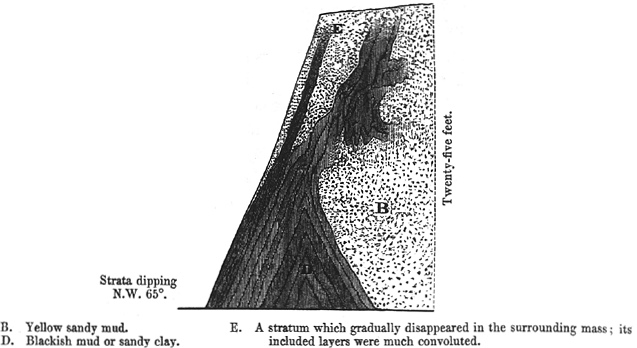
| B. |
Yellow sandy mud. |
E. |
A stratum which gradually
disappeared in the surrounding mass; its included layers were much
convoluted. |
| D. |
Blackish mud or sandy clay. |
Gregory Bay in the Eastern Part of the Strait of Magellan.
sists of finely laminated yellow mud (B), which, a little further to the right, includes many fragments of rock and loses its laminated character. On the left it alternates with layers of blackish mud (D), which are inclined at an angle of 65°, and at the foot of the cliff form a regular saddle. Many of these layers lose themselves in the yellow sandy mud in the most singular convolutions. In another cliff, Fig. 3. a bed, about eighteen inches thick and thirty feet in length, of fine sandy clay, lying in a coarser sort, dips gently at one end, and at the other is bent back under itself. The subordinate layers in this stratum are curved in basin-, or rather urn-shaped folds about a foot wide, and are placed at nearly equal intervals, so as to resemble some architectural ornament. They cannot always be traced from one basin to the other. The extreme degree of their curvature shows that they were not deposited in so many furrows at the bottom of the sea: it may, perhaps, be conjectured, that during the great and unequal pressure to which the whole mass has been subjected, the finer-grained laminated matter of which these urn-shaped basins consist, yielded more readily, and slided in between the parts exposed to a less force. With respect to the agency by which both sections have been contorted, from the general undisturbed state of the whole country and of the imme-
[page] 423
diately joining beds, and likewise from the peculiarity of the flexures in Fig. 2, I could not at the time persuade myself it was by ordinary violence from below, and no other solution occurred to me. Mr. Lyell* has shown, that in the districts
Fig. 3.
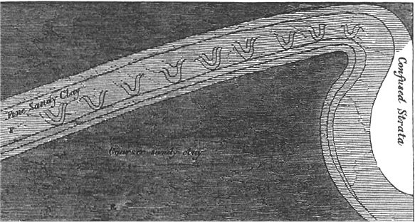
Gregory Bay. (For commencement of description see last page.)
in Europe where the till and boulders occur, most curiously contorted layers are directly superimposed on undisturbed beds, and he suggests as one explanation, the lateral force exerted by stranded icebergs. As we have here also the till and boulders, the forcing up and mingling together of these sedimentary deposits, have, perhaps, been effected by this same agency†; an agency, however, which in most cases appears merely to have prevented the separation of the drifted materials into distinct layers.
3. Island of Chiloe.
Passing from the extreme southern part of the continent along the west coast, I did not land south of lat. 47°. It was, however, between lat. 49° and 50° that the fragment of granite, described in my Journal,1 was seen floating on an iceberg twenty miles from its parent glacier, and therefore we may feel sure that erratic boulders occur in this space. Between lat. 47° and the southern extremity of
* Philosophical Magazine, 1840, p. 379: Mr. Lyell on the Boulder Formation, &c., Proceedings, vol. iii. p. 178.2
† Capt. W. Graah,3 in his Expedition to the East Coast of Greenland, states that there is a part of the coast which derives its name of Puisortok from ice "shooting up from the bottom of the sea in such a manner and in such masses, as in many years to make it utterly impassable." The cause of this singular phænomenon is unknown. Capt. Graah suggests amongst other causes, that these masses may be the remains of icebergs frozen to the bottom; but is it not much more probable that the icebergs were first driven deeply into the soft bed of the sea, and that they did not become disengaged until their whole upper parts had been washed away and their buried sides loosened by the melting of the ice?
1 Journal of researches, p. 282.
2 Lyell 1840a.
3 Wilhelm August Graah (1793-1863), Danish naval captain and explorer. Graah 1837.
[page] 424
Chiloe I landed on several parts of the seaward coast, but did not notice a single boulder: as, however, it is separated from the Cordillera by intervening high land, the absence of erratic blocks might have been expected.
At Chiloe I again found transported boulders in vast numbers. This island is a hundred miles long, extending from lat. 41° 46' to 43° 26'; and it lies parallel to the Cordillera, at the distance of about thirty miles from their base. It consists of mica-slate with two volcanic formations, largely bordered, chiefly on the eastern and northern sides, with horizontally stratified beds of tertiary sandstone and volcanic grit; the sandstone in some places passing into a loosely aggregated conglomerate. On the eastern coast the land is indistinctly modelled into successively rising plains, of which the superficial parts, and the whole thickness of some of the lower plains are composed of stratified shingle. This accumulation, where it caps the tertiary deposits, is evidently of subsequent formation; but I do not pretend to distinguish, in all cases, the shingle beds of more recent origin, from the above-mentioned tertiary conglomerate. The boulders occur in extraordinary numbers on the whole line of the eastern and northern beaches, and likewise to the height of at least 200 feet on the land. I saw a few imbedded in the cliffs of gravel; and as many extensive reefs show that there has been much denudation, I presume that many of the masses were originally included in the gravel. The boulders are likewise very numerous on the islets, which lie close to the eastern coast of Chiloe, and are separated from it by channels, which, although very narrow, vary in depth from 50 to more than 300 feet. In two places where I visited the outer or western coast of Chiloe, I did not see any transported blocks, nor did I during a ride of about thirty miles across the central high land.
The boulders consist of several varieties of granite and syenite; those of the latter rock are common on the northern beaches; but all the masses which I noticed thirty miles southward were of granite. Their parent rock probably exists in the Cordillera: an intelligent resident pointed out to me several varieties of syenite and granite at the northern end of the island, which, he assured me, he had seen forming whole mountains in the vicinity of Reloncavi Sound, which is situated in the same latitude: if so, these boulders must have travelled more than forty miles. I saw no granite or syenite in Chiloe, there is certainly none on the northern or on the eastern coast, the whole of which I examined, and I feel pretty sure none occurs in the northern part of the island; but it is not improbable that some of the western heights, which were estimated at 3000 feet, may be formed of granite. If any of the boulders have come from the heights of Chiloe, they have crossed a broad and level border of the tertiary deposits; but it is far more probable that all came from the Cordillera. The larger boulders were quite angular, and resembled fragments at the foot of a steep mountain. One mass of granite at Chacao
[page] 425
was a rectangular oblong, measuring fifteen feet by eleven, and nine feet high: another on the north shore of Lemuy islet was pentagonal, quite angular, and eleven feet on each side; it projected about twelve feet above the sand, with one point sixteen feet high: this fragment of rock almost equals the larger blocks on the Jura. There were very many others from two-thirds to a quarter of these dimensions. The boulders amongst the islets were in fewer numbers and more rounded than those on the open parts of the eastern coast; but I believe this remark applies only to the smaller masses, which may have been rounded subsequently to their first transportal.
The position of the boulders at the extreme northern point of Chiloe, where a headland about 250 feet high is joined to Lacuy peninsula by a quite low neck, deserves further notice. This headland, from the similarity of its composition, height and stratification, must once have been continuous with the coast of Chiloe. The ancient currents of the sea, which almost insulated the headland, deposited on its inland side, and on the opposite coast, beds of regularly stratified shingle. Some boulders were enclosed in these strata, and many very large angular ones of syenite were lying both on the low sandy isthmus, and on its sides at a height of 150 feet; and transported blocks were certainly far more numerous here than in any other part of the surrounding country. Anterior to the elevation, which has taken place within the post-pliocene period, the headland must have been an island, and the present low neck of land the bottom of a channel, open to the rush of tidal waters which flowed between Chiloe and the mainland of America. We thus see, even more clearly than in Tierra del Fuego, that there is an evident relationship between the distribution of the boulders, and the lines of either anciently or now existing straits. From this consideration, I was at first surprised at the occurrence of numerous blocks in the tortuous channels, between the islets and eastern coast of Chiloe; but I overlooked the fact, that, anterior to the modern period of elevation just alluded to, the middle part of Chiloe, in the line of the Lake Cucao, must, from its lowness, have been breached by a transverse channel. Had the space between Chiloe and the Cordillera been converted into land, the boulders, in their position with respect to their probable parent rocks, in their size and angular shape, would have resembled those on the Jura; the blocks of granite now lying between the islets, being the representatives of those which, M. Agassiz has lately shown, occur in the interior valleys of that range.1
Of the few imbedded boulders which I saw, most were in the stratified gravel; but I find in my note-book two sections obtained in the southern half of the island, and described as consisting of hardened mud, including angular as well as rounded fragments of far-transported rocks, and in one instance a boulder.2 These deposits
1 Agassiz 1838.
2 See the Port Desire notebook.
[page] 426
evidently are similar to those called 'till,' and I feel nearly sure that they were unstratified; but not being then aware of their interest, I merely compared them to the deposits in eastern Tierra del Fuego, and I here record only what I at the time wrote down. On the inner side of one of the Chonos Islands, a little south of Chiloe, in lat. 43° 50', there are cliffs about 300 feet high, which I likewise only partially described, as formed of blackish hardened mud with scattered pebbles of various sizes, some well rounded, some but slightly: as I especially noted that the gravel in the upper part of the cliff was stratified, I presume there was little arrangement in the lower. In one layer of loose sand at the base of this cliff, where the hardened mud passed into laminated sandy clay, I found a quantity of comminuted marine shells with a fresh aspect, but too much broken to be characterized. At Chiloe also, in one place where a mass of till passed into fine-grained, laminated beds, I found two or three fragments of a Cytheræa.1 I must, however, observe, that the absence of marine remains in these beds of till, is much less remarkable than in those of Great Britain, because the surrounding stratified formations here contain but very few shells. Indeed in Chiloe I found none, excepting where the sandstone contained calcareous concretions.
With respect to the age of the boulder formation of Chiloe, and I may add, of Tierra del Fuego, I have no precise information. The whole east coast of the island has been elevated certainly from twenty to forty feet, and probably much more, within the post-pliocene period; for on the peninsula of Lacuy (near where I have described the boulders on the low neck) I found, at a height of 350 feet, a great bed of existing shells, out of which forest trees were growing. I have stated, that in eastern Tierra del Fuego the boulder formation has also been elevated within this same period. Without we suppose that the boulders were deposited in a deep sea, which does not appear very probable from the nature and stratification of the accompanying deposits, or without we suppose great oscillations of level of the land, the boulder formation must have been accumulated since the commencement of the post-pliocene æra, or but little before it. From indirect evidence, also, and therefore to be received with limited confidence, I came to the same conclusion with regard to the boulders on the lower plain at Santa Cruz. It is worthy of notice, that geologists have referred the dispersal of the boulders which lie scattered over the temperate parts of the northern hemisphere to this period.
I have stated in my Journal, that northward of Chiloe (lat. 41° 47') I met with no fragments of far-transported rock which can be classed with the erratic boulders just described;—their great size, frequent angularity, and complete separation by wide valleys or arms of the sea from their parent source, being taken as their distinctive characters: I had opportunities of observing them in the country around Valdivia, Concepcion, and many parts of central and northern Chile. In these
1 A clam.
[page] 427
same districts I did not meet with any beds of till. North of the Strait of Magellan, on the sea-shores of Patagonia* and La Plata, neither boulders nor beds of till occur in the same latitudes, under which both are present on the Pacific. With respect to the erratic masses, we may infer from what has been shown in the ascent of the Santa Cruz, that their absence is owing to the wide space separating the shore of the Atlantic from the Cordillera. In my Journal I have endeavoured to show in detail, that, in the northern parts both of the Old and New World, and in the southern parts of South America, the dispersal of boulders has been limited, in approaching the tropics, to nearly the same latitudes, and that no true blocks of this description have been observed in the inter-tropical regions†; and we may now be permitted to suspect that beds of 'till' will be found to be confined to the same parallels of latitude as the boulders.
4. Remarks on the Glaciers of Tierra del Fuego, and on the Transportal of Boulders.
In the remainder of this paper I will make a few remarks on the glaciers of Tierra del Fuego, and on the means of transportal of the boulders. I had no opportunity of landing on any glacier, but we passed in the Beagle and Magdalen channels within two miles of several. The mountains were covered with snow, and the glaciers formed many short arms, which descended to the beach, and terminated in
* I may here mention, that on East Falkland Island, although situated in the same latitude with Tierra del Fuego, and lying only 250 miles eastward of it, and with mountains above 2000 feet in height, I did not observe any erratic boulders. As it may occur to some geologists that the island may have received its chief elevation, subsequently to the period of the dispersal of the boulders on the main-land, I will observe, that the facts are directly opposed to such a view, for I could not find any elevated marine shells on this island; whereas I did not land on a single point of the coast of Patagonia, or of eastern Tierra del Fuego, without meeting with them.
† In my Journal (p. 289, and Appendix, p. 615), where I have considered the apparent exceptions to this statement, I accidentally omitted one case. Near Rio de Janeiro I met some large-sized boulders of greenstone, containing iron pyrites; they were perfectly rounded, and therefore wanted that character of angularity, which, though far from being always a concomitant, may, where it is present, be considered as eminently distinctive. I could not see the greenstone in situ in the immediate neighbourhood, but the extreme rankness of the vegetation quite precluded accurate investigation. Mr. Caldcleugh (Travels, vol. ii. p. 195) observed greenstone boulders on the road to Villa Rica, and Spix (Travels, Eng. Transl. vol. i. p. 272)1 observed others on the road to Santa Cruz. Mr. Fox,2 Minister Plenipotentiary at Rio de Janeiro, informed me that he found similar blocks on the islands of St. Sebastian and St. Catherine, and at Port Alegre on the southern coast of Brazil. Nevertheless, it is not improbable that in all these cases the parent rock was not far distant. I found two greenstone dykes near Rio de Janeiro: Von Eschwege3 mentions others, and Mr. Fox observed one on St. Sebastian. Besides many obvious means of transportal to moderate distances of large fragments of rock, now that geologists generally admit that most countries have undergone slow oscillations of level, we must not overlook the power which the surf during gales would have, on an exposed and gently inclined surface, of driving onwards blocks of rock from the top of one line of beach to that of another, as the sea gradually encroached on the land.
1 Spix 1824.
2 Henry Stephen Fox (1791-1846), British diplomat, Minister Plenipotentiary, Buenos Aires, 1831-1832; Rio de Janeiro, 1833-1836.
3 Wilhelm Ludwig von Eschwege (1777-1855), German miner, geologist and geographer. Eschwege 1832.
[page] 428
low perpendicular cliffs of ice. The surface of these glaciers, even to a considerable height on the mountains, was of a bright azure colour and perfectly clean, as were the floating fragments. This is what might have been expected, from the shortness of the glaciers, from their not being bordered by precipices, and from their not being formed by the junction of two or more smaller streams of ice. Although the chief characteristic of the climate of the southern parts of South America seems to be its equability, yet the glaciers cannot descend very slowly, for large masses are continually breaking from the cliffs of ice. We were witnesses of one fall in the Beagle channel; and the water was strewed with smaller pieces: Capt. King* mentions several bays and channels in Tierra del Fuego almost choked up with them; Mr. Bynoe† informed me that as many as fifty icebergs were seen together in Sir G. Eyre's Sound: behind the peninsula of Tres Montes, in a latitude corresponding to that of the lake of Geneva, some Spanish missionaries‡, in an account of their voyage, describe an arm of the sea as crowded with icebergs of all sizes. Some of the fragments of ice which are thus detached are of immense size: Mr. Kirke§ met with one in an inland creek, situated in the corresponding latitude as Paris, which was estimated at forty-two feet in height, and was aground, where bottom could not be obtained with a line of 126 feet. This mass was therefore at least 168 feet in height, equal to a lofty church: how violently must the tranquil waters of the retired creek have been agitated when it fell! Capt. King, describing another case||, compares the crash to a broadside reverberating through these lonely regions. In the Beagle channel the insignificant fall which we witnessed, caused a wave that nearly destroyed our boats, though hauled up on the shore, and at the distance of half a mile from the cliff of ice.1 These waves seem to displace and drive before them the fragments of rock lying on the beach. Although the glaciers I saw were quite clean, many of the icebergs described by Mr. Kirke1 in Sir G. Eyre's Sound were dark coloured, and on the surface of one, several blocks of granite and serpentine were found.
The glaciers in the Beagle channel were generally bordered by a tongue of land, formed of huge fragments of rock, and many boulders were strewed on the neighbouring shores. The only glacier which I approached closely, descended to the head of a creek, formed on one side by a wall of mica-slate, and on the other by a broad promontory, about fifty or sixty feet high, and apparently composed entirely of enormous fragments, chiefly of granite. One of these was ninety feet in circumference, and projected six feet above the sand. This promontory, which originally no doubt was a lateral moraine, projects nearly half a mile beyond the
* Voyages of the Adventure and Beagle, vol. i. pp. 56, 58, 140, 258.
† The Author's Journal of Researches, p. 283.
‡ Ibid., Appendix, p. 613.
§ Voyages of the Adventure and Beagle, vol. i. p. 337.
|| Ibid., vol. i. p. 140.
1 J. Kirke mate on the Beagle.
2 See FitzRoy 1839, p. 217.
[page] 429
extremity of the glacier, and is in parts covered by old trees: hence we must infer, that the glacier formerly extended considerably further than it now does.
It would be useless even to allude to the difficulties which affect every theory of the transportal of erratic boulders, excepting that by the agency of ice; but after the remarkable discoveries of Venetz, Charpentier, Agassiz, and others, of the great extension in Europe of moraines formed by ancient glaciers, it is necessary to observe, that neither the 'till' beds of eastern Tierra del Fuego, which pass into and are regularly interstratified with a great formation of horizontally laminated sandstone, containing marine remains; nor the stratified gravel and till, which form low plains on the shores of Chiloe, and cap in regular beds the tertiary strata, can have been produced like ordinary moraines; and, therefore, that the imbedded boulders cannot have been propelled by the glaciers themselves. I am led to the same conclusion with respect to the till of southern Tierra del Fuego, which forms a level plain and a fringe around several islands, and which in one part passes into a regularly stratified deposit. The boulders on the lower levels at the head of the Santa Cruz river are strewed on land, which certainly has been modelled by the action of the sea. Those on the 1400 feet plain are sixty-seven miles from the Cordillera, of which the highest pinnacle is only 6400 feet, and the general range considerably lower; this little inclination of the surface, with the absence of mounds or ridges on it, and the angularity of the fragments, are opposed to the notion that the blocks have been pushed to this great distance by glaciers. Hence I conclude, that in the two first-mentioned districts it is quite certain, and in the three latter highly probable, that the boulders were transported by floating ice.
The fact of many of the blocks on the northern end of Chiloe being different from those thirty miles southward, where there must anciently have been a channel across the island, is not opposed to the foregoing conclusion: for the tidal currents must have drained, according to the number and position of the seaward channels, determinate spaces of the area between Chiloe and the Cordillera; and according to the situation of the spot whence the iceberg with its cargo of rock was first launched, so would it be swept towards one or the other channel. The varying winds, no doubt, would partly influence the course of icebergs, but, from their floating very deeply, the currents would act far more powerfully on them. Nor is the circumstance of the boulders on the high and low plain of Santa Cruz being of different kinds of rock any difficulty; for after the change of level in the land, necessary to account for the existence of the lower plains, we might have anticipated that some of the glaciers which formerly debouched on the coast would cease doing so; and that rocks hitherto submerged beneath the sea would become exposed, and their fragments falling on the glaciers would be transported with the icebergs.
[page] 430
It appears that masses of floating ice, by which fragments of rock are conveyed, are produced in two ways, and under circumstances considerably different although often acting together, namely, by the breaking off of icebergs from glaciers descending into the sea, and by the actual freezing of the surface of the sea or its tributary streams. Great boulders can be included in ice by this latter means only (with rare exceptions) where the winter is extremely cold, as in the Gulf of Bothnia1 and on the shores of North America. A large proportion of the fragments thus enclosed will generally have been exposed to the wearing influences of the sea-beach; and from the ice being in a sheet, they will be liable to be repeatedly stranded in shallow places, and thus to become still more worn. The other method of transportal, namely, by the descent of glaciers to the sea-level, and the production of icebergs, is far from necessarily requiring an extremely cold winter; for the low descent of glaciers seems to depend (other circumstances being alike) in a much greater degree on the summer not being hot enough to melt the ice and snow, than on the winter being very cold. Hence, as I have endeavoured to show in my Journal (chap. xiii.), glaciers in South America descend to the sea from mountains not very lofty, and in latitudes extraordinarily low compared with those in Europe under which the same phænomenon takes place; and yet, the vegetable and animal productions of this kind of climate have, in some degree, an inter-tropical character.
M. Agassiz has shown that blocks of rock are not imbedded in the ice of the Swiss glaciers, except high up near their sources, and that those numerous masses which lie on the surface, from not being exposed to much abrasion, remain angular: hence only loose angular blocks of rock (as was the case with those on the floating ice in Sir G. Eyre's Sound) can be transported by icebergs, detached from the glaciers of temperate countries. And to effect this, the icebergs must be floated off perpendicularly and in large masses, for otherwise the loose fragments would be at once hurled into the sea. These remarks do not necessarily apply to icebergs formed under a polar climate, for if a glacier in its descent, reached the sea before the fragments of rock which had fallen on the soft snow had come to the surface, icebergs would be produced with imbedded fragments of rock: I have described in the 'Geographical Journal'* the case of one huge fragment thus circumstanced, seen drifting far from land in the Antarctic Ocean.†
As one of the above two methods of conveying erratic boulders, namely, that by icebergs from glaciers, is now in action on the South American shores, we are na-
* Geographical Journal, 1839, p. 528.2
† Dr. Merten's observed many fragments of rock imbedded only just above the level of the sea in the lateraal wall of the glaciers at Spitzbergen, but he never saw any in the cliffs of ice facing the sea.—Edinburgh New Phil. Journal, 1841, pp. 173 and 176.3
1 The north part of the Baltic Sea, between Sweden and Finland.
2 Darwin 1839.
3 Charles Martins (1806-1889), French physician and traveller who visited Spiztbergen in the Recherche in 1838. His name was misspelled by the New Edinburgh Philosophical Journal, and differently by Darwin, Martins 1841.
[page] 431
turally led to conclude, that this was the chief agent in the enormous amount of transportal formerly effected over a more extended area. It would indeed require the strongest evidence to make one believe that the surface of the sea, or even of rivers, between lat. 41° and 42°, had ever been frozen thickly enough to enclose the huge masses of rock which we now find stranded on the island of Chiloe. The angularity of their forms at this latter place and at Santa Cruz, accords with their transportal by icebergs; but it is not improbable that the other agency, namely, the freezing of the sea, may formerly have been instrumental in Tierra del Fuego, and especially in the southern parts of that country, where the boulders frequently show signs of attrition, as if they had been worn on a sea-beach. In endeavouring, therefore, to determine, in any country where boulders occur, the nature of the climate during their dispersal, we should attend not only to the character of the contemporaneous organic productions, but likewise to the shape of the fragments and to their position; for these circumstances would aid us in discovering whether they had been imbedded in sheet-ice, or carried on the surface of deeply-floating icebergs.
[plate XL]
